WATER AND WASTEWATER COMMISSION BUDGET COMMITTEE MINUTES FRIDAY, MAY 8, 2026 WATER AND WASTEWATER COMMISSION BUDGET COMMITTEE REGULAR MEETING MINUTES FRIDAY, MAY 8, 2026 The Water and Wastewater Commission Budget Committee convened in a Regular meeting on Friday, May 8, 2026, at 625 E 10th Street in Austin, Texas. Budget Committee Members in Attendance: Committee Chair Marcela Tuñón, Committee Vice Chair Chris Maxwell-Gaines, Commissioner Shwetha Pandurangi, and Commissioner Evan Wolstencroft Budget Committee Members Absent: None. Chair Marcela Tuñón called the Water and Wastewater Commission Budget Committee to order at 10:03 a.m. PUBLIC COMMUNICATION: GENERAL None. DISCUSSION ITEMS 2. Review Fiscal Year 2027 Budget Schedule. Austin Water Deputy Director Joseph Gonzales presented the budget schedule. 1. Austin Water Financial Forecast Fiscal Year 2027-2031 Update. Austin Water Acting Assistant Director Christina Romero, Austin Water Acting Financial Manager Nam Nguyen, and Austin Water Financial Manager Frida Guo gave a briefing. DISCUSSION AND POSSIBLE ACTION ITEMS 3. Review and possible action to approve the Budget Committee meeting schedule. The motion to hold the next Budget Committee meeting on Thursday, June 11, 2026 at 3:00 p.m. was approved on Vice Chair Maxwell-Gaines’ motion, Commissioner Wolstencroft’s second on a 3-0 vote with Commissioner Pandurangi off the dais. FUTURE AGENDA ITEMS Send the current approved Austin Water Capital Improvement Plan for FY 2026-2030 to the Budget Committee members in advance of the next meeting. Chair Tuñón adjourned the meeting at 11:11 a.m. without objection. 1
Austin Water Austin Water Forecast Operating Requirements Cost Drivers City-wide base cost drivers $2.4 million increase in Market Study Adjustment $1.2 million increase in Health Insurance Cost Department-wide base cost drivers $2.5 million increase in 3% Inflation Contractual Cost $1.9 million increase in Chemical Cost $1.8 million increase in Utility Excavation Repair Street Cut Cost $1.2 million increase in Electric Services Cost ($1.8 million) decrease in Utility Billing System Support Debt Services & Transfers Out $16.5 million increase in Debt Service Requirements $8.9 million increase in Transfer to Wastewater CIP Fund $3.5 million increase in Transfer to Water CIP Fund $3.3 million increase in Transfer to General Fund $1.3 million increase in Transfer to Reclaimed Water CIP Fund $1.0 million increase in Administrative Support ($12.6) million decreases in Transfer Operating to Debt Defeasance Impact of new positions $5.0 million increase for 41 new positions
Austin Water FY2027 Forecast Staffing Request Summary EUM Attribute Alignment Sum of Number of New FTE Customer Experience & Satisfaction Enterprise Resiliency Financial Viability Infrastructure Strategy & Performance Operational Optimization Regulatory & Reliability Performance Stakeholder Understanding & Support Water Resource Sustainability Grand Total 4 13 1 8 8 3 2 2 41 Austin Water FY2027 Forecast Staffing Request Summary FTE # Position Title Position Type EUM Attribute Alignment Position Purpose 1 Austin Water (AMI) Meter Services Coordinator New FTE Customer Experience & Satisfaction 1 1 1 4 Customer Service Representative Temp Conversion Customer Experience & Satisfaction Customer Service Representative Temp Conversion Customer Experience & Satisfaction Customer Service Representative Temp Conversion Customer Experience & Satisfaction Total Customer Experience & Satisfaction 1 Engineer C New FTE Enterprise Resiliency 1 Treatment O & M Tech Senior Temp Conversion Enterprise Resiliency 1 Industrial Utility Electrician II New FTE Enterprise Resiliency This position will implement a team-oriented approach to address customer service issues within the AMI system. The role involves diagnosing the causes of service interruptions and taking corrective actions to resolve any abnormal conditions. Additionally, the position will provide direct support to customers, AMI project teams, AMI vendors, and stakeholders. This position offers direct customer service and support AW's Customer Service Contact Center (dispatch) team, which operates 24/7, 365 days a year. It converts a temporary position into a full- time budgeted role. This position offers direct customer service and support AW's Customer Service Contact Center (dispatch) team, which operates 24/7, 365 days a year. It converts a temporary position into a full- time budgeted role. This position offers direct customer service and support AW's Customer Service Contact Center (dispatch) team, which operates 24/7, 365 days a year. It converts a temporary position into a full- time budgeted role. This position involves managing contracts and overseeing indefinite delivery-indefinite quantity (IDIQ) contracts. It provides time- sensitive construction services during routine operations and emergencies to fulfill service deliverables, performance indicators, and overall support for the water and wastewater needs of the Austin community. These positions will support preventative and corrective maintenance requirements for all 137 Lift Stations. The number of lift stations is expected to expand, along with equipment such as generators and backflow prevention devices. The Odor Control and Collection System Flow Monitoring program will be expanded as well. These positions will replace current temporary employees. An Industrial Utility Electrician II is needed to help …
SPECIAL CALLED MEETING OF THE ETHICS REVIEW COMMISSION JUNE 11, 2026, AT 6:00 P.M. AUSTIN CITY HALL, BOARDS & COMMISSIONS ROOM, #1101 301 W 2ND STREET AUSTIN, TEXAS 78701 Some members of the Ethics Review Commission may be participating by videoconference. The meeting may be viewed online at: http://www.austintexas.gov/page/watch-atxn-live Public comment will be allowed in-person or remotely via telephone. Speakers may only register to speak on an item once either in-person or remotely and will be allowed up to three minutes to provide their comments. Registration no later than noon the day before the meeting is required for remote participation by telephone. To register to speak remotely, contact Lizette Benitez at (512) 974-2915 or Lizette.benitez@austintexas.gov. CURRENT COMMISSIONERS: William Ross Pumfrey, Chair Luis Figueroa Haksoon Andrea Low Cynthia Soliz Brittany Sharkey, Vice Chair Patrick Keel Wallace Lundgren Jeffrey Campbell Michael Lawson William King Brian McGiverin AGENDA CALL TO ORDER PUBLIC COMMUNICATION: GENERAL The first 10 speakers signed up prior to the meeting being called to order will each be allowed a three- minute allotment to address their concerns regarding items not posted on the agenda. BRIEFINGS 1. 2. Briefing from League of Women Voters- Austin Area regarding City Council Candidate Forum planning. Briefing from staff regarding City Council Candidate Forum planning, including schedule and locations. [Mia Warner, Strategic Communications Consultant, Austin Communications and Engagement] EXECUTIVE SESSION The Ethics Review Commission may announce it will go into Executive Session pursuant to Chapter 551.071 of the Texas Government Code to receive advice from legal counsel on any matter listed in this agenda. Page 1 of 3 3. The Ethics Review Commission may announce it will go into Executive Session pursuant to Chapter 551.071 of the Texas Government Code to receive advice from legal counsel to discuss: A complaint filed by Kimberly Hawkins against Paige Ellis raising claimed violations of City Charter, Article III, Section 8 (Limits on Campaign Contributions and Expenditures). PRELIMINARY HEARING 4. A complaint filed by Kimberly Hawkins against Paige Ellis raising claimed violations of City Charter, Article III, Section 8 (Limits on Campaign Contributions and Expenditures). APPROVAL OF MINUTES 5. Approve the minutes of the Ethics Review Commission meeting on April 22, 2026. DISCUSSION AND ACTION ITEMS 6. 7. Conduct the annual election of officers (Chair, Vice-Chair, and Secretary). Review the need for the Working Group to Review and Revise ERC Rules and Regulations (Commissioners Sharkey and Figueroa). WORKING GROUP …
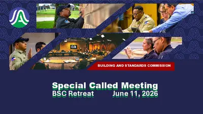
SPECIAL CALLED MEETING OF THE BUILDING AND STANDARDS COMMISSION THURSDAY, JUNE 11, 2026, AT 12:00 P.M. PERMITTING AND DEVELOPMENT CENTER, ROOM 4001 6310 WILHELMINA DELCO DRIVE AUSTIN, TEXAS Some members of the Building and Standards Commission may be participating by videoconference. Public comment will be allowed in-person or remotely via telephone. Speakers may only register to speak on an item once either in-person or remotely and will be allowed up to three minutes to provide their comments. Registration no later than noon the day before the meeting is required for remote participation by telephone. To register to speak remotely, contact Melanie Alley, 512-974-2679, dsdcredbsc@austintexas.gov. CURRENT COMMISSIONERS: Michael Francis, Chair Lisa Garza Myra Martinez Carrie Stewart, Fire Marshal (Ex Officio) Jeffrey Musgrove, Vice Chair Grant Gilker Manesh Nair Harrison Brown Mia Ibarra Raisch Tomlanovich SPECIAL CALLED MEETING RETREAT AGENDA CALL TO ORDER PUBLIC COMMUNICATION: GENERAL The first five speakers signed up prior to the meeting being called to order will each be allowed a three- minute allotment to address their concerns regarding items not posted on the agenda. DISCUSSION AND ACTION ITEMS The Commission will receive presentations and training on each of the following topics: 1. 2. 3. Discussion of Retreat Goals and Objectives. Discussion led by Robert Moore, Division Manager - CRED, Austin Development Services. Case Review & Escalations Division Overview Presenter: Robert Moore, Division Manager - CRED, Austin Development Services. Commission Jurisdiction, Procedures, Authority, Obligations and Appeals Presenter: Sonya Herrera, Assistant City Attorney, Austin Law Department 4. 5. 6. 7. 8. Life of a Case from Cradle to Grave Presenter: Daniel Armstrong, Division Manager, Code Field Inspections, Austin Development Services. Repeat Offender Program Overview Presenter: Matthew Noriega, Division manager, ROP, Austin Development Services Obtaining a Permit, Planning & Permitting Procedures Presenter: Steve Leitch, Chief Plans Examiner, Austin Development Services Presenter: Viktor Auzenne, Division Manager, Austin Development Services Discussion of Accounting Estimate for Cases Escalated to the Building and Standards Commission Presenter: Robert Moore, Division Manager, Austin Development Services Social Services & Outreach Programs Presenter: Scott Mata, Social Worker, Austin Development Services Presenter: Nicholas Gentry, Program Manager I, Austin Housing Department FUTURE AGENDA ITEMS ADJOURNMENT The City of Austin is committed to compliance with the Americans with Disabilities Act. Reasonable modifications and equal access to communications will be provided upon request. For assistance, please contact the Liaison or TTY users’ route through 711. A person may request language access accommodations …
BUILDING AND STANDARDS COMMISSION Special Called Meeting BSC Retreat June 11, 2026 Objectives Introduction of Executive Staff & Presenters – Robert Moore Learn about the roles and responsibilities of the Case Review & Escalations Division (CRED). – Robert Moore Discuss Commission jurisdiction, procedures, authority, obligations and appeals. – Sonya Herrera Understand the life of a case from cradle to grave. - Dan Armstrong Objectives (Continued) Review Repeat Offender Program (ROP) History, Policy, and Requirements. – Matthew Noriega Understand permitting and how it relates to BSC cases. – Steve Leitch Cover BSC case processing expenses and relation to penalty off set. – Robert Moore Housing & Social Services Programs/Assistance – Scott Mata/Nicholas Gentry Development Services Department Executive Staff DSD Assistant Director Tracey Allen Support Services DSD Director Keith Mars Development Services Department Executive Staff DSD Assistant Director Daniel Word DSD Site & Subdivision Inspections & Code Compliance DSD Assistant Director Elaine Garrett DSD Environmental Tree Inspections & Enforcement & Code Compliance Development Services Department Executive Staff DSD Building Official Todd Wilcox DSD Assistant Director Brenda De La Garza Building Plan Review & Inspections Development Services Department Executive Staff DSD Acting Assistant Director Joydeep Goswami Land Development Review Development Services Department Executive Staff DSD Code Division Manager Mathew Noriega Repeat Offender Program DSD Code Division Manager Daniel Armstrong Code Compliance North Team Development Services Department Executive Staff DSD Chief Plans Examiner Steve Leitch Assistant City Attorney Sonya Herrera Oversees CRED program. Managerial support for team members. Serves as a liaison between DSDCC Executive Team, Law Department, Field staff and CRED staff. Attends Pre-BSC and BSC meetings. Reviews appeals and agendas. Code Division Manager Robert Moore Case Review & Escalations Attends all Pre-BSC and BSC meetings Oversees and monitors all cases with BSC Orders. Serves as a SPOC for City Law (non-compliant BSC cases submitted to City Law for further enforcement action. Ensures BSC Failure to Comply letters are sent to owner(s)/interested parties, for non-compliance of Supervisor Marlayna Wright the BSC Order. SPOC for demolition program. Assists in training CRED programs to field staff for the Code Compliance Academy and support sessions. Case Review & Escalaions (CRED) Coordinator/ liaison between DSDCC and BSC. Quality control & review of submitted cases. Prepares case exhibits and relevant material. Pre BSC communication with DSDCC staff. Facilitates cases and presents recommended …
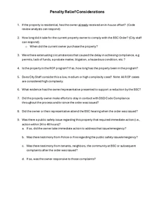
Penalty Relief Considerations 1. If the property is residential, has the owner already received an in-house offset? (Code review analysts can respond). 2. How long did it take for the current property owner to comply with the BSC Order? (City staff can respond). o When did the current owner purchase the property? 3. Were there extenuating circumstances that caused the delay in achieving compliance, e.g. permits, lack of funds, a probate matter, litigation, a hazardous condition, etc.? 4. Is the property in the ROP program? If so, how long has the property been in the program? 5. Does City Staff consider this a low, medium or high complexity case? Note: All ROP cases are considered high complexity. 6. What evidence has the owner/representative presented to support a reduction by the BSC? 7. Did the property owner make efforts to stay in contact with DSD Code Compliance throughout the process and/or since the order was issued? 8. Did the owner or their representative attend the BSC hearing when the order was issued? 9. Was there a public safety issue regarding this property that required immediate action (i.e., action within 24 to 48 hours)? a. If so, did the owner take immediate action to address that issue/emergency? b. Was there testimony from Police or Fire regarding the public safety issue/emergency? c. Was there testimony from tenants, neighbors, the community at BSC or subsequent complaints after the order was issued? d. If so, was the owner responsive to those complaints?
REGULAR MEETING OF THE ZERO WASTE ADVISORY COMMISSION WEDNESDAY, JUNE 10, 2026, AT 6:00 P.M. CITY HALL ROOM 1001 301 W 2ND ST. AUSTIN, TEXAS Some members of the Zero Waste Advisory Commission may be participating by videoconference. The meeting may be viewed online at: http://www.austintexas.gov/page/watch-atxn-live Public comment will be allowed in-person or remotely via telephone. Speakers may only register to speak on an item once either in-person or remotely and will be allowed up to three minutes to provide their comments. Registration no later than noon the day before the meeting is required for remote participation by telephone. To register to speak remotely, contact Gustavo Valle, 512-974-4350, Gustavo.Valle@austintexas.gov. CURRENT [BOARD MEMBERS OR COMMISSIONERS]: Gerry Acuna, Chair Ian Steyaert, Vice Chair Melissa Caudle Michael Drohan CALL TO ORDER Caitlin Griffith John L. Harris Ali Ishaq Iris Suddaby AGENDA Seth Whaland Vacant Vacant PUBLIC COMMUNICATION: GENERAL The first 5 speakers signed up prior to the meeting being called to order will each be allowed a three- minute allotment to address their concerns regarding items not posted on the agenda. APPROVAL OF MINUTES 1. Approve the minutes of the Zero Waste Advisory Commission Regular meeting on April 8, 2026 DISCUSSION AND ACTION ITEMS 2. Discuss whether the City-owned FM 812 Landfill should be reopened as a Construction and Demolition Recycling Diversion Facility, along with historical landfill volume and revenue data leading up to its closure. STAFF BRIEFINGS 3. Staff briefing on the status of Austin Resource Recovery Operational and Administrative projects by Ron Romero, Assistant Director of Austin Resource Recovery. FUTURE AGENDA ITEMS ADJOURNMENT The City of Austin is committed to compliance with the Americans with Disabilities Act. Reasonable modifications and equal access to communications will be provided upon request. For assistance, please contact the Liaison or TTY users’ route through 711. A person may request language access accommodations no later than 48 hours before the scheduled meeting. Please call or email Gustavo Valle email Recovery Department, Gustavo.Valle@austintexas.gov to request service or for additional information. 512-974-4350 Resource Austin or at at For more information on the Zero Waste Advisory Commission, please contact Gustavo Valle at 512- 974-4350 or Gustavo.Valle@austintexas.gov.
To: From: Date: Zero Waste Advisory Commission Ron Romero, Assistant Director, Austin Resource Recovery June 10, 2026 Subject: Director’s Monthly Report to the Zero Waste Advisory Commission Waste and Recycling Workers Proclamation Waste and Recycling Workers Week is observed annually during the week of June 17th. It honors the essential work of waste management and recycling professionals who keep our communities clean and safe. Their daily efforts, from collecting trash and recyclables to managing hazardous waste, help to protect public health, maintain clean neighborhoods, and support environmental sustainability. Mayor Pro Tem Vela will issue a proclamation on June 15th in honor of Austin Resource Recovery's dedicated employees. Qualified Processor for Construction & Demolition Debris Processing Austin Resource Recovery (ARR) has approved the application of Texas Landfill Management, LLC or Texas Disposal Systems (TDS) to become a City of Austin Construction and Demolition Qualified Processor. TDS’s status as a Qualified Processor is effective from April 2026 to April 2028, contingent upon the Processor maintaining requirements in City code during that timeframe. The facility was audited by City approved third party Registered Evaluator: Zero Waste Strategies. They found that the average material diversion rate from the landfill at this facility was 67%. The Qualified Processor designation allows general contractors developing construction projects across Austin to reduce required documentation to report to the City by being able to report to the Qualified Processors facility diversion rate in lieu of documenting hauling a tipping receipt throughout the project. City of Austin & Travis County Interlocal Agreement On May 28, 2026, Council approved Austin Resource Recovery’s (ARR) request to negotiate and execute an interlocal agreement between City of Austin and Travis County. The agreement involves the Recycle and Reuse Drop-Off Center at 2514 Business Center Drive. The City and County have had versions of this agreement since 1997. Previous agreements involved only the Household Hazardous Waste portion of the facility. The new agreement also captures the services of the recycling side of the facility where customers can drop off items such as single- stream, electronics, plastic film, appliances, rigid plastics, and Styrofoam. Circular Showcase (All Districts) On May 14, four small businesses with circular business models pitched to judges for a chance to win prize money. The $10,000 grand prize winner was Pickle Envy, who creates fermented foods from local and surplus produce— preventing food waste while offering a nutritious alternative. Other Showcase finalists included …
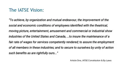
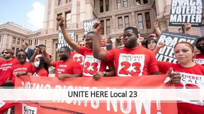
REGULAR MEETING of the TOURISM COMMISSION WEDNESDAY, JUNE 10, 2026, AT 2:30 P.M. CITY HALL, COUNCIL CHAMBERS ROOM 1001 300 W. 2ND STREET AUSTIN, TEXAS Some members of the Tourism Commission may be participating by videoconference. The meeting may be viewed online at: http://www.austintexas.gov/page/watch-atxn-live Public comment will be allowed in-person or remotely via telephone. Speakers may only register to speak on an item once either in-person or remotely and will be allowed up to three minutes to provide their comments. Registration no later than noon the day before the meeting is required for remote participation by telephone. To register to speak remotely, contact April Thedford, (512) 404-4054 or april.thedford@austintexas.gov CURRENT COMMISSIONERS: Ed Bailey, Chair, District 5 Greg Chanon, District 2 Francisco “Cisco” Gamez, District 1 Stefani Mathis, District 8 Maxwell "Max" Pearce, District 7 Catherine Whited, District 9 AGENDA CALL TO ORDER PUBLIC COMMUNICATION: GENERAL Cristina Masters, Vice Chair, District 10 Bishop Chappell, District 6 Sophia Gonzalez, District 4 Anna Panossian, Mayoral Dani Pruitt, District 3 The first 10 speakers signed up prior to the meeting being called to order will each be allowed a three- minute allotment to address their concerns regarding items not posted on the agenda. APPROVAL OF MINUTES 1. Approve the minutes of the Tourism Commission Regular Meeting on May 13, 2026. DISCUSSION ITEMS 2. Presentation by International Alliance of Theatrical Stage Employees (IATSE) Local No. 205, regarding an overview of the organization and its role in the tourism industry. Presentation by Nikki Combs, Business Agent. 3. Presentation by Unite Here regarding an overview of the organization and its role in the tourism industry. Presentation by Rachel Melendes, Political Director. WORKING GROUP UPDATE 4. Update from Hotel Occupancy Tax (H.O.T.) Grant Programs Working Group regarding upcoming meetings and goals. FUTURE AGENDA ITEMS ADJOURNMENT The City of Austin is committed to compliance with the Americans with Disabilities Act. Reasonable modifications and equal access to communications will be provided upon request. For assistance, please contact the Liaison or TTY users’ route through 711. A person may request language access accommodations no later than 48 hours before the scheduled meeting. Please call or email April Thedford or (512) at Austin Convention Center Department, april.thedford@austintexas.gov to request service or for additional information. 404-4054 at For more information on the Tourism Commission Board please contact April Thedford at (512) 404-4054 or april.thedford@austintexas.gov. The next Tourism Commission meeting will be on July …
TOURISM COMMISSION REGULAR MEETING WEDNESDAY, MAY 13, 2026 MINUTES The Tourism Commission convened in a Regular meeting on Wednesday, May 13, 2026, at 301 W. 2nd Street in Austin, Texas. Chair Ed Bailey called the Tourism Commission Meeting to order at 2:35 p.m. Commissioners in Attendance: • Ed Bailey, Chair, District 5 • Cristina Masters, Vice Chair, District 10 • Bishop Chappell, District 6 • Francisco “Cisco” Gomez, District 1 • Sophia Gonzalez, District 4 • Stefani Mathis, District 8 • Anna Panossian, Mayoral • Maxwell “Max” Pearce, District 7 • Dani Pruitt, District 3 • Catherine Whited, District 9 Commissioner in Attendance Remotely: • Greg Chanon, District 2 PUBLIC COMMUNICATION: GENERAL None present. APPROVAL OF MINUTES 1. Approve the minutes of the Tourism Commission Regular Meeting on April 8, 2026. The minutes from the Tourism Commission regular meeting on April 8, 2026 were approved on Commissioner Panossian’s motion, Vice Chair Masters’s second on a 10-0 vote, Commissioner Chanon was off the dais. STAFF BRIEFINGS 2. Staff briefing regarding the recent commission vacancy that was filled; updates and introductions of new liaison assignments; and an overview of upcoming meetings and key deadlines. 1 The presentation was made by Felicia Burleson, Staff Liaison, Austin Convention Center. DISCUSSION ITEMS 3. Presentation by Austin Police Department Association (Police Union) on officer perspectives related to downtown public safety, staffing realities, and how frontline conditions impact the visitor experience and special event support. The presentation was made by Michael Bullock, President, Austin Police Department Association. Discussed. Presentation by Austin Homeless Strategies and Operations regarding an overview of the 4. City’s council-approved strategic plan to address homelessness and to understand how this work intersects with Austin’s visitor experience. The presentation was made by Natasha Ponczek, Business Process Consultant, Austin Homeless Strategies and Operations. Discussed. DISCUSSION AND ACTION ITEMS 5. Approve the creation of a working group. The motion to approve the formation of a Hotel Occupancy Tax (HOT) Grant Programs Working Group to evaluate how grant programs support Austin’s tourism economy and identify ways the Tourism Commission can strengthen program impact through recommendations to Austin City Council. The group will assess long-term outcomes to ensure HOT-funded programs remain effective, equitable, and aligned with Austin’s cultural and tourism priorities was approved at the April 8, 2026, regular meeting of the Tourism Commission on Commissioner Pruitt’s motion, Commissioner Panossian’s second on a 7-0 vote, with Commissioners Chappell, Mathis …
The IATSE Vision: “To achieve, by organization and mutual endeavour, the improvement of the social and economic conditions of employees identified with the theatrical, moving picture, entertainment, amusement and commercial or industrial show industries of the United States and Canada, ...to insure the maintenance of a fair rate of wages for services competently rendered; to assure the employment of all members in these industries; and to secure to ourselves by unity of action such benefits as are rightfully ours...” Article One, IATSE Constitution & By-Laws Who is Local 205? Labor Day Appreciation 2025 Local 205 STAGE CREWS AT WORK… Carpenters at work building scenery at Long Center Electricians at work on lighting looks at Long Center Stagehands at work, set, show and strike at Austin City Limits music festival 2023 COUNTRY MUSIC TELEVISION Show Crew At Work in Austin Convention Center Conventions and Tradeshows
UNITE HERE Local 23 Hospitality Workers Union • Airport Concessions • Hotels • Tech Food Service • University Food Service Workers in Action! Local 23 members joined the coalition of organizations and elected officials to win the highest minimum wage in the country - $20!
REGULAR MEETING OF THE HIV PLANNING COUNCIL FINANCE AND ASSESSMENT COMMITTEE WEDNESDAY, JUNE 10TH, 6:00 P.M. PERMITTING AND DEVELOPMENT CENTER ROOM 1203 6310 WILHELMINA DELCO DRIVE AUSTIN, TEXAS Some members of the HIV PLANNING COUNCIL may be participating by videoconference. The meeting may be viewed online at: Join the meeting now Public comment will be allowed in person or remotely via telephone or Teams. Speakers may only register to speak on an item once either in person or remotely and will be allowed up to three minutes to provide their comments. Registration no later than noon the day before the meeting is required for remote participation. To register to speak, call or email the Office of Support, (737)- 825-1684 or hivplanningcouncil@austintexas.gov CURRENT HIV PLANNING COUNCIL FINANCE/ALLOCATIONS AND STRATEGIC PLANNING/NEEDS ASSESSMENT COMMITTEE MEMBERS: Drew Kyler Empty, Committee Chair Kelle’ Martin Katherine Brandhuber Coats Henry Chan Brandon Diaz Judith Hassan AGENDA CALL TO ORDER PUBLIC COMMUNICATION: GENERAL The first 10 speakers signed up no later than noon on 6/9/2026 will each be allowed a three-minute allotment to address their concerns regarding items not posted on the agenda. APPROVAL OF MINUTES 1. Approve the minutes of the HIV Planning Council regular meeting of the Finance/Allocations and Strategic Planning/Needs Assessment Committee on May 13th, 2026 CONFLICT OF INTEREST DECLARATIONS 2. Members will declare conflict of interest with relevant agenda items, service categories, and/or service standards. STAFF BRIEFINGS 3. Introductions/Announcements 4. Office of Support Staff Briefing 5. Administrative Agent Staff Briefing DISCUSSION ITEMS 6. Discussion of Notice of Award update 7. Discussion of profile of Provider Capacity and Capability 8. Discussion of Priority Setting and Resource Allocation (PSRA) Data Binder DISCUSSION AND ACTION ITEMS 9. Discussion and approval of Finance and Assessment Committee Chair a. Drew Kyler FUTURE AGENDA ITEMS 10. Discussion of social calendar and workplan calendar ADJOURNMENT Indicative of action items The City of Austin is committed to compliance with the American with Disabilities Act. Reasonable modifications and equal access to communications will be provided upon request. Meeting locations are planned with wheelchair access. If requiring Sign Language Interpreters or alternative formats, please give notice at least 2 days (48 hours) before the meeting date. TTY users’ route through Relay Texas at 711. For More Information on the HIV Planning Council, please contact HIV Planning Council Office of Support at (737) 825-1684.
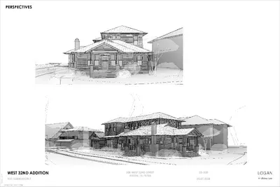
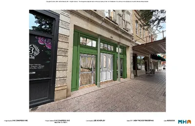
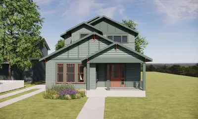
REGULAR MEETING OF THE HISTORIC LANDMARK COMMISSION ARCHITECTURAL REVIEW COMMITTEE WEDNESDAY, JUNE 10, 2026, AT 4:00 P.M. PERMITTING AND DEVELOPMENT CENTER, CONFERENCE ROOM 1401 6310 WILHELMINA DELCO DR AUSTIN, TEXAS Some members of the Historic Landmark Commission may be participating by videoconference. Public comment will be allowed in-person or remotely via telephone. Speakers may only register to speak once either in-person or remotely and will be allowed up to three minutes to provide their comments. Registration no later than noon the day before the meeting is required for remote participation by telephone. To register to speak remotely, please use the QR code or link at the end of this document. For questions, please email preservation@austintexas.gov. KEVIN KOCH JAIME ALVAREZ HARMONY GROGAN CURRENT COMMISSIONERS AGENDA CALL TO ORDER PUBLIC COMMUNICATION: GENERAL The first 10 speakers signed up prior to the meeting being called to order are allowed three minutes to speak on items not posted to the agenda. APPROVAL OF MINUTES 1. Approve the minutes of the Architectural Review Committee regular meeting on May 13, 2026. DISCUSSION ITEMS 2. 3. 4. 5. 6. 7. PR-2026-008188 – 1005 E. 8th St. Robertson/Stuart & Mair Local Historic District Council District 1 Proposal: Demolish a contributing building. Applicant: Robbie MacGregor C14H-2020-0087 – 3908 Avenue B Baker School Council District 9 Proposal: Place three 40ft shipping containers on the property with no alterations to the landmarked building. Applicant: Brittany Garcia 4105 Avenue G Hyde Park Local Historic District Council District 9 Proposal: Restore the front and side elevations of a contributing building. Construct a new 2- story addition at the rear of the existing home, a new 2-story detached garage, and an accessory unit at the rear of the property with alley-access. Applicant: Tim Cuppett PR-2026-032504; HR-2026-036164 – 304 W. 42nd St. Hyde Park Local Historic District Council District 9 Proposal: Demolish a contributing building and construct a new residence. Applicant: Jennifer Alonzi HR-2026-057184 – 208 W. 32nd St. Aldridge Place Local Historic District Council District 9 Proposal: Construct an addition to a contributing building. Applicant: Andrew Logan C14H-1982-0001-f – 916 Congress Ave. Larmour Block (F) Council District 9 Proposal: Construct an event space behind the existing façade. Applicant: Patrick Georgiou 8. 9. 10. 11. C14H-1978-0024 – 1501 E. 12th St. Southgate-Lewis House Council District 1 Proposal: Implement Phase II capital improvements including foundation repairs, HVAC replacement and provide ADA access, ADA ramps, and sidewalks. …
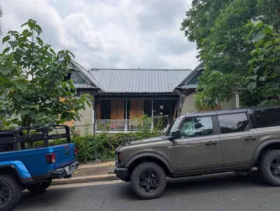
REGULAR MEETING OF THE HISTORIC LANDMARK COMMISSION ARCHITECTURAL REVIEW COMMITTEE WEDNESDAY, MAY 13, 2026, AT 4:00 P.M. PERMITTING AND DEVELOPMENT CENTER, CONFERENCE ROOM 1401 6310 WILHELMINA DELCO DR AUSTIN, TEXAS Some members of the Historic Landmark Commission may be participating by videoconference. X KEVIN KOCH X JAIME ALVAREZ X HARMONY GROGAN CURRENT COMMISSIONERS DRAFT MINUTES CALL TO ORDER: 4:00PM PUBLIC COMMUNICATION: GENERAL The first 10 speakers signed up prior to the meeting being called to order are allowed three minutes to speak on items not posted to the agenda. APPROVAL OF MINUTES 1. Approve the minutes of the Architectural Review Committee regular meeting on April 8, 2026. MOTION: Approve the April 8, 2026 meeting minutes. Motion by Commissioner Grogan. Commissioner Koch seconded the motion. Vote 2-0. Commissioner Alvarez off the dais. The motion passed. DISCUSSION ITEMS 2. C14H-1980-0009 – 3414 Lyons Rd. James Smith Place Council District 3 Proposal: Repair and stabilize the exterior. Applicant: Tracy Geyer The applicant presented their proposal. The committee provided feedback. 3. 4. 5. 6. 7. 4412 Avenue B Hyde Park Local Historic District Council District 9 Proposal: Rehabilitate the Ramsey House with a new roof and other structural improvements. Applicant: Tere O'Connell The applicant presented their proposal. The committee provided feedback. PR-2026-032504; HR-2026-036164 – 304 W. 42nd St. Hyde Park Local Historic District Council District 9 Proposal: Demolish a contributing building and construct a new residence. Applicant: Jennifer Alonzi The applicant presented their proposal. The committee provided feedback. HR-2026-021800 – 1107 W. 9th St. Castle Hill Local Historic District Council District 9 Proposal: Remodel a contributing house. Applicant: Nathan Griffith The applicant presented their proposal. The committee provided feedback. 705 West Lynn St. West Line National Register Historic District Council District 9 Proposal: New construction. Applicant: Mike McHone; Dan Illescas MOTION: Take item #6 out of order, and hear it after item #1 on a motion by Commissioner Grogan. Second by Commissioner Koch. Vote 2-0. Commissioner Alvarez off the dais. The motion passed. The applicant presented their proposal. The committee provided feedback. PR-2026-040403 – 1808 E. Cesar Chavez St. Council District 3 Proposal: Demolish a ca. 1930 building. Applicant: Karen Rodewald The applicant did not attend. ADJOURNMENT: 5:30PM The City of Austin is committed to compliance with the Americans with Disabilities Act. Reasonable modifications and equal access to communications will be provided upon request. For assistance, please contact the Liaison or TTY users’ route …
REGULAR MEETING OF THE EARLY CHILDHOOD COUNCIL WEDNESDAY, JUNE 10, 2026, AT 9:00 A.M. CITY HALL, BOARD AND COMMISSION ROOM #1101 301 WEST SECOND STREET AUSTIN, TEXAS Some members of the Early Childhood Council may be participating by videoconference. Public comment will be allowed in-person or remotely via telephone. Speakers may only register to speak on an item once either in-person or remotely and will be allowed up to three minutes to provide their comments. Registration no later than noon the day before the meeting is required for remote participation by telephone. To register to speak remotely, contact Caitlin Oliver, 512-972-6205, Caitlin.Oliver@austintexas.gov. CURRENT BOARD MEMBERS/COMMISSIONERS: Choquette Hamilton, Chair Delphi Alvizo Yvette Cárdenas Cynthia McCollum Craig McNary Alice Navarro Eliza Sears AGENDA CALL TO ORDER PUBLIC COMMUNICATION: GENERAL Brooke Freeland, Vice Chair Christy Beauchemin Chloe Latham-Sikes Andrea McIllwain Brianna Menard Hilda Rivas The first five speakers signed up prior to the meeting being called to order will each be allowed a three-minute allotment to address their concerns regarding items not posted on the agenda. APPROVAL OF MINUTES 1. Approve the minutes of the Early Childhood Council Regular Meeting on May 13, 2026. DISCUSSION AND ACTION ITEMS 2. 3. Discussion of the legacy of Cathy McHorse and ways the Early Childhood Council can carry her work forward. Discussion and possible action to approve the Early Childhood Council’s 2027 goals to be included in the Council’s annual review. DISCUSSION ITEMS 4. 5. 6. 7. Presentation by Austin Independent School District (AISD) regarding AISD Head Start enrollment and locations. Presentation by Yvette Cárdenas, AISD Executive Director of Academic Programs; Amanda Bolding, AISD Head Start Administrator; and Elizabeth Scogland, AISD Early Learning Administrative Supervisor. Raising Travis County implementation updates from Hilda Rivas, Travis County Health & Human Services Research & Planning Division Senior Planner. Updates from the May Joint Inclusion Committee (JIC) meeting. Discussion of the time and location of the next regular meeting on Saturday, August 8, 2026. STAFF BRIEFINGS 8. Austin Public Health update about the National League of Cities Prenatal-to-Three Impact Lab and updates from related local early childhood groups such as Austin Chapter of the Texas Association for the Education of Young Children, Success By 6 Coalition, Child Care Regulation, and Workforce Solutions Capital Area. Briefing by Caitlin Oliver, Austin Public Health. FUTURE AGENDA ITEMS ADJOURNMENT The City of Austin is committed to compliance with the Americans with Disabilities Act. Reasonable …
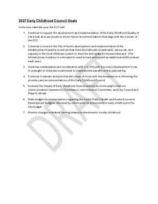
2027 Early Childhood Council Goals In the new calendar year, the ECC will: 1. Continue to support the development and implementation of the Early Childhood Quality of Life Study and use results to inform future recommendations that align with the mission of the ECC. 2. Continue to monitor the City of Austin development and implementation of the Infrastructure Academy to ensure that there are sufficient investments, resources, and capacity in the local childcare system to meet the anticipated increased demand. (The Infrastructure Academy is estimated to need to train and upskill an additional 4,000 workers each year.) 3. Continue collaboration and coordination with City of Austin Economic Development’s role in oversight of childcare investments to maximize the benefits of this partnership. 4. Continue to elevate and prioritize the voices of those with lived experience in informing the priorities and recommendations of the Early Childhood Council. 5. Increase the impact of Early Childhood Council actions by continuing to improve communications between ECC members, Joint Inclusion Committee, and City Council and Mayor’s offices. 6. Make budget recommendations regarding the Austin Public Health and Austin Economic Development budgets, informed by community for investments in early childhood in the City budget. 7. Monitor changes in federal funding related to investments in early childhood.
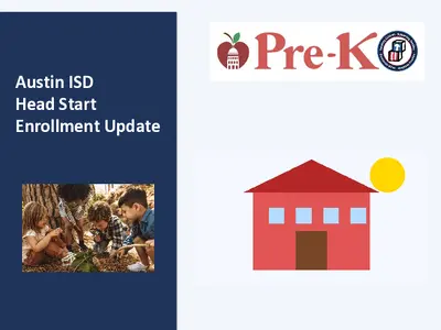
Austin ISD Head Start Enrollment Update Presentation Overview Head Start Enrollment Overview 2024–2025 Head Start Enrollment Data 2025–2026 Head Start Enrollment Data Operational Context Locations & Changes for School Consolidation Student Demographic Considerations Questions and Discussion 2024–2025 Austin ISD Head Start Enrollment 204 Funded Enrollment 202 Average Monthly Enrollment 239 Cumulative Enrollment Enrollment remained near funded capacity throughout the school year with strong attendance outcomes. 2025–2026 Austin ISD Head Start Enrollment Funded Enrollment: 204 Current Operational Enrollment: 136 Avg. Monthly enrollment: 134 Cumulative Enrollment: 152 A Change of Scope application has been submitted and remains pending federal approval. Austin ISD Head Start Locations 24-25 School Year 25-26 School Year Guerrero-Thompson ES Houston ES Jordan ES Langford ES Oak Springs ES Rodriguez ES Sanchez ES Uphaus ECC * 8 locations Guerrero-Thompson ES Houston ES Jordan ES Langford ES Oak Springs ES Rodriguez ES Sanchez ES Uphaus ECC * 7 locations Austin ISD Head Start Location Change for 2026-2027 SY Oak Springs Blackshear • Oak Springs is undergoing modernization and students will be reassigned and join Blackshear during construction • Head Start services will relocate to Blackshear Elementary • Campuses are located approximately 1.5 miles apart. • Families will continue to have access to services within the same community. • Minimal transportation impact is anticipated. Student Demographic Considerations • Continued services for children and families with the highest levels of need • Support for dual language learners • Services for children experiencing homelessness and foster care involvement • Support for children with disabilities • Focus on continuity of services during district transitions Questions and Discussion Questions and Discussion Thank you! Austin ISD Pre-K 3 & Pre-K 4 Enrollment Update 26-27 SY Austin ISD Pre-K Enrollment Update as of June 4, 2026 PreK-3 (enrolled) PreK-4 (enrolled) Total (enrolled) 367 25 397 1168 578 1746 1535 603 2138 Eligible Tuition Total Seats remaining = 3094 Fall 2025 Demographics of Closing Elementary Campuses Campus Barrington Becker Dawson Reilly Ridgetop Sunset Valley Widén Winn Montessori % of Economic Disadvantage % of Emergent Bilingual % of Pre- Kindergarten 97.07% 18.37% 78.57% 37.62% 16.27% 29.96% 91.76% 58.92% 74.27% 23.11% 31.82% 35.11% 13.07% 30.41% 52.94% 43.51% 14.33% 15.53% 5.84% 10.66% 10.13% 15.09% 13.82% 20.81% draft
REGULAR MEETING OF THE COMMISSION ON AGING WEDNESDAY, JUNE 10, 2026 AT 12:00 P.M. AUSTIN CITY HALL, BOARDS & COMMISSIONS ROOM 301 W 2ND ST AUSTIN, TEXAS 78701 Some members of the Commission on Aging may be participating by videoconference. Public comment will be allowed in-person or remotely via telephone. Speakers may only register to speak on an item once either in-person or remotely and will be allowed up to three minutes to provide their comments. Registration no later than noon the day before the meeting is required for remote participation by telephone. To register to speak remotely, call or email Ryan Sperling, 512-974-3568, Ryan.Sperling@austintexas.gov. CURRENT COMMISSIONERS: Richard Bondi, Chair Teresa Ferguson, Vice Chair Austin Adams Suzanne Anderson Martin Kareithi Faith Lane Fred Lugo Judi L Nudelman Jennifer Scott Luan Tran AGENDA CALL TO ORDER PUBLIC COMMUNICATION: GENERAL Preston Tyree Henry Van de Putte Selina Yee Xiaoyi Zeng The first ten speakers signed up prior to the meeting being called to order will each be allowed a three-minute allotment to address their concerns regarding items not posted on the agenda. APPROVAL OF MINUTES 1. Approve the minutes of the Commission on Aging regular meeting of May 13, 2026. DISCUSSION ITEMS 2. Review of Age Friendly Action Plan Focus Area 1 and discussion about actions the commission can take to support the Age Friendly Action Plan Focus Area 1. 3. Discussion regarding the commission’s 2025 Annual Internal Review & Report. 4. Update on topics discussed at the May 27th Joint Inclusion Committee meeting. 5. Update on the progress of recommendations 20251210-008: Older Adult Icon on City Demographer Website and 20260311-009: Addressing the Digital Divide for Older Adults. 6. Presentation regarding the Westminster CARES Foundation. Presentation by Charles Borst, Executive Director, Westminster. DISCUSSION AND ACTION ITEMS 7. Approve a recommendation to Council for a proclamation on Social Wellness Month. 8. Approve a recommendation to Council for a proclamation on National Wellness Month. 9. Approve a recommendation to Council for a proclamation on Implicit Bias Awareness Day 10. Approve a recommendation to Council for a proclamation on National Senior Citizens Day. 11. Approve a recommendation to Council for a proclamation on Healthy Aging Month. 12. Approve a recommendation to Council for a proclamation on National Senior Center Month. 13. Approve a recommendation to Council for a proclamation on National Preparedness Month. 14. Approve a recommendation to Council for a proclamation on Fall Prevention …
COMMISSION ON AGING MINUTES REGULAR MEETING WEDNESDAY, MAY 13, 2026 The Commission on Aging convened in a regular meeting on Wednesday, May 13, 2026, at Austin City Hall, Boards and Commissions Room 1101, 301 W 2nd Street in Austin, Texas. Chair Bondi called the Commission on Aging Meeting to order at 12:12 p.m. Commissioners in Attendance: Richard Bondi (Chair) Fred Lugo Judi Nudelman Henry Van de Putte Xiaoyi Zeng Commissioners in Attendance Remotely: Teresa Ferguson (Vice Chair) Suzanne Anderson Martin Kareithi Faith Lane Jennifer Scott Luan Tran Preston Tyree PUBLIC COMMUNICATION: GENERAL None. APPROVAL OF MINUTES 1. Approve the minutes of the Commission on Aging regular meeting of April 8, 2026. There was a motion by Commissioner Lugo, seconded by Commissioner Nudelman, to amend the minutes to change the vote count in Item 8 to 8-0 and list Commissioner Van de Putte as abstaining, and on Item 9 to correct the spelling of Commissioner Van de Putte’s name. The amendment was approved on a 9-0 vote. The minutes were approved as amended on Commissioner Nudelman’s motion, Commissioner Lugo’s second on a 9-0 vote. Vice Chair Ferguson and Commissioners Kareithi and Scott were off the dais. Commissioners Adams and Yee were absent. 1 STAFF BRIEFINGS 2. Briefing regarding emergency preparedness services for older adults. Presentation by Ana Urueta, Emergency Management Manager, Austin Public Health. Item 2 was taken up after Item 3 without objection. The presentation was made by Ana Urueta, Emergency Management Manager, Austin Public Health. DISCUSSION ITEMS 3. Presentation regarding ongoing changes to Medicare. Presentation by Rosemary Monsivais, Medicare Consultant, Independent Insurance Broker. The presentation was made by Rosemary Monsivais, Medicare Consultant, Independent Insurance Broker. 4. Update on closing out the 2021-2025 Age Friendly Action Plan. Presentation by Nicole Alexander, Age Friendly Program Coordinator, Halana Kaleel, Public Health Community Engagement Specialist, Austin Public Health. The presentation was made by Nicole Alexander, Age Friendly Program Coordinator, and Halana Kaleel, Public Health Community Engagement Specialist, Austin Public Health. 5. Discussion regarding activities around Older Americans Month. Discussion was held. 6. Discussion regarding the 2026 Fair Housing & Economic Mobility Conference held on April 29th. Discussion was held. 7. Update on discussion held and action taken at the most recent Joint Inclusion Committee meeting. Discussion was held. 8. Discussion regarding the current version of the new Age Friendly Action Plan, including how the commission can build, bridge, and champion to support the …
BOARD/COMMISSION RECOMMENDATION Commission on Aging Recommendation Number: 20260610-010: National Senior Citizens Day– August 21st WHEREAS, older adults contribute immeasurably to the cultural, civic, economic, and social vitality of Austin through volunteerism, caregiving, mentorship, public service, and lifelong achievement1; and WHEREAS, National Senior Citizens Day2 provides an opportunity to recognize and celebrate the wisdom, resilience, and contributions of older adults in our community; and WHEREAS, many older adults continue to strengthen Austin through employment, community leadership, artistic expression, advocacy, and intergenerational engagement3; and WHEREAS, the City of Austin is committed to fostering an Age-Friendly community where older adults can live safely, remain engaged, and age with dignity and independence; and WHEREAS, supporting the health, inclusion, transportation, housing, nutrition, and social well-being of older adults benefits the entire community4. NOW, THEREFORE, BE IT RESOLVED that the Commission on Aging encourages the Austin City Council to proclaim August 21st as “National Senior Citizens Day” in Austin, Texas and encourage Austinites to recognize and celebrate the contributions, leadership, volunteerism, caregiving, experience, and resilience of older adults who strengthen the social, cultural, civic, and economic fabric of Austin. Date of Approval: _____________________________ Record of the vote: Attest: _____________________________________________ 1 Older Adults Contributing to Society: Why It Matters, September 20, 2024 2 Created by President Ronald Reagan through Proclamation 5847 in 1988 and since designated by the Administration for Community Living 3 Recognizing the value that older adults bring to our communities | 2Life Communities, April 2025 4 Report to Congress - Aging in the United States: A Strategic Framework for a National Plan on Aging
BOARD/COMMISSION RECOMMENDATION Commission on Aging Recommendation Number: 20260610-011: Healthy Aging Month– September WHEREAS, the Austin Quality of Life Study for Older Adults found that physical and social well-being is essential infrastructure for healthy aging1; and WHEREAS, Healthy Aging Month2 promotes positive aging and encourages older adults to take steps to improve their physical, mental, social, and emotional well-being3; and WHEREAS, access to preventive care, nutritious food, safe housing, physical activity, transportation, and social connection are key factors in healthy aging4; and WHEREAS, Austin’s older adults enrich the community through volunteerism, caregiving, civic participation, and sharing of experience and knowledge5, 6; and WHEREAS, community-based services and programs help older adults maintain independence, reduce isolation, and remain connected to their neighborhoods and support systems7; and WHEREAS, the City of Austin recognizes the importance of promoting Age-Friendly policies and equitable access to resources that support healthy aging for all residents. NOW, THEREFORE, BE IT RESOLVED that the Commission on Aging encourages the Austin City Council to proclaim September 2026 as “Healthy Aging Month” in Austin and encourage Austinites, caregivers, health professionals, community organizations, and policymakers to support programs, services, and 1 Austin Older Adult Quality of Life Study 2025-CAC-University of Indianapolis.pdf - Google Drive 2 While Healthy Aging Month originated with Healthy Aging® magazine more than 15 years ago, the broader concept of "healthy aging" is now strongly aligned with the World Health Organization and the United Nations Decade of Healthy Ageing (2021–2030), which gives the observance additional credibility beyond its original creation. 3 Healthy Aging at Any Age | Healthy Aging | CDC 4 Social Determinants of Health - Healthy People 2030 | odphp.health.gov 5 Older Adults Contributing to Society: Why It Matters 6 The Impact Of Senior Volunteering On The Community - Senior Strong 7 The Impact of Home- and Community-Based Services on the Health of Older Adults: A Meta-Analysis - Xuanru Lyu, Yangyang Fan, 2024 healthy lifestyle practices that promote dignity, independence, wellness, and quality of life for older adults. Date of Approval: _____________________________ Record of the vote: Attest: _____________________________________________
BOARD/COMMISSION RECOMMENDATION Commission on Aging Recommendation Number: 20260610-012: National Senior Center Month– September WHEREAS, the Austin Quality of Life Study for Older Adults found that older adults report high regard for programming and staff at the city’s libraries, parks, senior centers, and nonprofit organizations and recommended expanding social activities for older adults1; and WHEREAS, senior centers serve as vital community hubs that provide opportunities for social engagement, wellness, education, nutrition, recreation, volunteerism, and supportive services, while strengthening communities through civic participation, lifelong learning, volunteer service, and intergenerational connections2, 3; and WHEREAS, senior centers help reduce social isolation and promote healthy aging by connecting older adults to resources, friendships, and meaningful activities4; and WHEREAS, Austin-area senior centers and older adult programs support the health and well-being of diverse populations through culturally responsive and accessible programming; and WHEREAS, National Senior Center Month5 recognizes the important role senior centers play in enhancing quality of life and promoting dignity, independence, and inclusion for older adults. NOW, THEREFORE, BE IT RESOLVED that the Commission on Aging encourages the Austin City Council to proclaim September 2026 as “National Senior Center Month” in Austin to recognize the important role senior centers and older adult programs play in reducing isolation, promoting healthy aging, encouraging lifelong learning and volunteerism, and connecting older adults to supportive services and community engagement opportunities. Date of Approval: _____________________________ Record of the vote: 1 Austin Older Adult Quality of Life Study 2025-CAC-University of Indianapolis.pdf - Google Drive 2 How Senior Centers Champion Communities, National Council on Aging, April 2026 3 Why Senior Centers Are the Heart of Our Community: A Closer Look at Their Impact on Seniors, March 2025 4 How Senior Centers Help Older Adults Stay Social | AgeRight Blog, May 2025 5 Sponsored annually by the National Council on Aging Attest: _____________________________________________
BOARD/COMMISSION RECOMMENDATION Commission on Aging Recommendation Number: 20260610-013: National Preparedness Month– September WHEREAS, the Austin Quality of Life Study for Older Adults found residents experienced consistent frustration with disaster planning and safety1; and WHEREAS, emergencies and disasters can have a disproportionate impact on older adults, people with disabilities, caregivers, and others with access or functional needs, particularly those who may face mobility, medical, transportation, communication, or social isolation challenges2, 3; and WHEREAS, preparedness planning, accessible communication, and community support systems are essential to protecting the health and safety of vulnerable residents during emergencies4; and WHEREAS, the City of Austin encourages residents to create emergency plans, maintain emergency supply kits, and stay informed about local emergency preparedness resources; and WHEREAS, National Preparedness Month5 highlights the importance of community resilience, neighbor support, and coordinated emergency planning to help ensure no resident is left behind during times of crisis. NOW, THEREFORE, BE IT RESOLVED that the Commission on Aging encourages the Austin City Council to proclaim September 2026 as “National Preparedness Month” in Austin and encourages residents, caregivers, neighborhood groups, and community organizations to support emergency preparedness planning, accessible communication, and community resilience efforts that help protect older adults and individuals with access and functional needs during emergencies and disasters. Date of Approval: _____________________________ Record of the vote: 1 Austin Older Adult Quality of Life Study 2025-CAC-University of Indianapolis.pdf - Google Drive 2 Emergency Preparedness Concerns for Older Adults, CDC 3 The Impact of Disasters on Older Adults, AARP, 2022 4 Older Adults: Disaster Planning | SAMHSA 5 Designated by Federal Emergency Management Agency (FEMA) Attest: _____________________________________________