. RECOMMENDATION TO COUNCIL Austin Travis County Public Health Commission Recommendation Number: 20260603-004 BRIDGING PUBLIC HEALTH FUNDING: WHEREAS according to the 2025 Austin-Travis County Community Health Assessment (CHA), the foundation of health in Austin and Travis County is shaped by longstanding structural conditions. Historical patterns of racial segregation, economic exclusion, and neighborhood disinvestment continue to influence present-day access to education, income, and opportunity. These inequities are especially pronounced in East Austin, where residents face compounded disadvantages, and WHEREAS the City of Austin 1928 Master Plan designated then East Avenue as the dividing racial line between East and West Austin, which was later replaced by Interstate 35, serving as a reinforced physical barrier between East and West Austin, and WHEREAS the CHA demonstrates that Interstate 35 traffic and congestion have exacerbated health disparities of those living in East Austin, leading to less access to quality care and healthy foods, increased rates of chronic diseases such as diabetes and infectious disease, poor maternal health outcomes, and increased socioeconomic inequities, and WHEREAS the CHA shows that Interstate 35 creates chronic stressors such as traffic noise, heat, and pollution, leading to poor mental health and stress of those living nearby, and WHEREAS City Council has touted Cap and Stitch as a once in a generation opportunity to repair the physical divide created by Interstate 35 and assist in repairing over 100 years of segregation, and WHEREAS City Council has welcomed the creation of new public spaces for civic participation and unlocking long-term economic and community benefits, and WHEREAS the CHA clearly illustrates that neighborhoods east of Interstate 35 tend to have a lower life expectancy compared to neighborhoods west of Interstate 35, ranging as low as 69 years old in East Austin and as high as 88 years old in West Austin. Data show that residents in historically underserved areas, particularly in East Austin, continue to experience shorter lifespans due to higher rates of chronic disease, fewer health care options, and limited access to other key . resources, pointing to the urgent need for place-based investments and equity-focused public health strategies to close the life expectancy gap and improve outcomes for all residents, and WHEREAS according to the CHA, the conditions of the neighborhoods where people live have a direct and lasting impact on health outcomes. Insecure housing, poor walkability, exposure to traffic dangers, and gaps in infrastructure don’t just limit mobility, they compound …
AUSTIN TRAVIS COUNTY PUBLIC HEALTH COMMISSION Wednesday, May 6th, 2026 AUSTIN TRAVIS COUNTY PUBLIC HEALTH COMMISSION REGULAR MEETING MINUTES Wednesday, May 6th, 2026 The Austin Travis County Public Health Commission convened in a regular meeting on Wednesday, May 6th, 2026, at 301 West 2nd Street in Austin, Texas. Chair Natalie Poindexter called the Austin Travis County Public Health Commission Meeting to order at 2:35 pm. Board Members/Commissioners in Attendance: Natalie Poindexter, Chair Chris Crookham Jawad Ali Board Members/Commissioners in Attendance Remotely: Cara Dahlhausen, Vice Chair Martha Lujan Jacob Whitty William Rice Board Members/Commissioners Absent: None Ex-Officio and Staff in Attendance: Adrienne Sturrup, Director, Austin Public Health Dr. Desmar Walkes, Austin/Travis County Public Health Authority Alicia Ramirez, Government Affairs, Central Health Dani Romero, Staff Liaison, Austin Public Health Juanita Jackson, Staff Liaison, Austin Public Health Ex-Officio and Staff in Attendance Remotely: None Ex-Officio and Staff Absent: Ana Almaguel Perla Cavazos Megan Cermak PUBLIC COMMUNICATION: GENERAL Nicholas Littlejohn raised urgent safety and maintenance concerns regarding the Dove Springs Public Health Clinic. He reported a lack of facility upkeep, noting holes in the walls, potholes, debris like needles and diapers in the parking lot, missing restroom sharps containers, and the alleged use of banned Glyphosate. Additionally, Mr. Littlejohn highlighted critical security issues, including an adjacent encampment where individuals with weapons have reportedly harassed clinic staff, and noted operational problems with broken electric vehicle charging stations and outdated information. He concluded by stating he has compiled a complete list of these ongoing issues for the Commission's review. APPROVAL OF MINUTES 1. Approve the minutes of the Austin Travis County Public Health Commission regular meeting on May 6th, 2026. The minutes for the regular meeting of April 1st, 2026, were approved on Commissioner William Rice’s motion, Commissioner Chris Crookham’s second on a 7-0 vote. DISCUSSION ITEMS 1. Presentation and demonstration of RADD Platform by APH staff. The presentation was made by Phillip Bays, Christopher Collins and Brian Morris. 2. Receive updates from commissioners on assigned action items. Discussed. 3. Discuss draft recommendation “Sexual Health Funding” created by Commissioner Jacob Whitty. Commissioner Whitty presented the draft recommendation. Commissioners and ex- officio’s provided input and proposed changes. Commissioner Whitty will take input and rework the recommendation. 4. Discuss draft recommendation “Heat-Related Illness Prevention for Outdoor Workers”. Commissioner Dahlhausen presented the draft recommendation. Commissioners and ex-officio’s provided input and proposed changes. Commissioner Whitty will take input and rework …
. RECOMMENDATION TO COUNCIL Austin Travis County Public Health Commission Recommendation Number: 20260603-004 BRIDGING PUBLIC HEALTH FUNDING: WHEREAS according to the 2025 Austin-Travis County Community Health Assessment (CHA), the foundation of health in Austin and Travis County is shaped by longstanding structural conditions. Historical patterns of racial segregation, economic exclusion, and neighborhood disinvestment continue to influence present-day access to education, income, and opportunity. These inequities are especially pronounced in East Austin, where residents face compounded disadvantages, and WHEREAS the City of Austin 1928 Master Plan designated then East Avenue as the dividing racial line between East and West Austin, which was later replaced by Interstate 35, serving as a reinforced physical barrier between East and West Austin, and WHEREAS the CHA demonstrates that Interstate 35 traffic and congestion have exacerbated health disparities of those living in East Austin, leading to less access to quality care and healthy foods, increased rates of chronic diseases such as diabetes and infectious disease, poor maternal health outcomes, and increased socioeconomic inequities, and WHEREAS the CHA shows that Interstate 35 creates chronic stressors such as traffic noise, heat, and pollution, leading to poor mental health and stress of those living nearby, and WHEREAS City Council has touted Cap and Stitch as a once in a generation opportunity to repair the physical divide created by Interstate 35 and assist in repairing over 100 years of segregation, and WHEREAS City Council has welcomed the creation of new public spaces for civic participation and unlocking long-term economic and community benefits, and WHEREAS the CHA clearly illustrates that neighborhoods east of Interstate 35 tend to have a lower life expectancy compared to neighborhoods west of Interstate 35, ranging as low as 69 years old in East Austin and as high as 88 years old in West Austin. Data show that residents in historically underserved areas, particularly in East Austin, continue to experience shorter lifespans due to higher rates of chronic disease, fewer health care options, and limited access to other key . resources, pointing to the urgent need for place-based investments and equity-focused public health strategies to close the life expectancy gap and improve outcomes for all residents, and WHEREAS according to the CHA, the conditions of the neighborhoods where people live have a direct and lasting impact on health outcomes. Insecure housing, poor walkability, exposure to traffic dangers, and gaps in infrastructure don’t just limit mobility, they compound …
REGULAR MEETING OF THE EMMA S. BARRIENTOS MEXICAN AMERICAN CULTURAL CENTER ADVISORY BOARD WEDNESDAY, JUNE 3, 2026, AT 6:00 P.M. CITY HALL, BOARDS AND COMMISSIONS ROOM 301 W. 2ND STREET AUSTIN, TEXAS 78701 Some members of the Emma S. Barrientos Mexican American Cultural Center may be participating by videoconference. Public comment will be allowed in-person or remotely via telephone. Speakers may only register to speak on an item once either in-person or remotely and will be allowed up to three minutes to provide their comments. Registration no later than noon the day before the meeting is required for remote participation by telephone. To register to speak remotely, contact Michelle Rojas, 512-974-3771, Michelle.Rojas@austintexas.gov. CURRENT BOARD MEMBERS: Angelica Navarro (D-8), Chair Hilario “Larry” Amaro (D-10), Member Lynda Quintana (D-6), Member Noemi Castro (D-2), Member Raul “Roy” Reyna (D-1), Member Alexander “Al” Duarte (D-7), Member Selma Sanchez (D-9), Member John Estrada (D-3), Member Vacant (D-4), Member Cynthia “Cy” Herrera (D-5), Member Lillian “Lily” Zamarripa-Saenz (Mayor), Vice Chair AGENDA CALL TO ORDER PUBLIC COMMUNICATION: GENERAL The first 10 speakers signed up prior to the meeting being called to order will each be allowed a three-minute allotment to address their concerns regarding items not posted on the agenda. APPROVAL OF MINUTES 1. Approve the minutes of the Emma S. Barrientos Mexican American Cultural Center (ESB- MACC) regular meeting of May 6, 2026. STAFF BRIEFINGS 2. Staff briefing on May and June programs, marketing and outreach efforts, signature event planning, and staffing updates. (Sponsors: Navarro, Zamarripa-Saenz) Presenter(s): Olivia Tamzarian, ESB-MACC Culture and Arts Education Marketing & Outreach Representative, Austin Arts Culture, Music and Entertainment & Michelle Rojas, ESB-MACC Culture and Arts Education Manager, Austin Arts Culture, Music and Entertainment DISCUSSION ITEMS 3. Update on MACC Pocket Park Project. (Sponsors: Navarro, Zamarripa-Saenz) Presenter(s): Sue Hagerty, Project Manager, Austin Capital Delivery Services & Kimberly Gilbertson, Project Coordinator, Austin Capital Delivery Services DISCUSSION AND ACTION ITEMS 4. 5. 6. Review current working groups to assess membership status and determine whether to add or eliminate groups. (Sponsors: Herrera, Zamarripa-Saenz) Approve a recommendation in support of six Hispanic/Latino Quality of Life Advisory Commission FY 26-27 budget recommendations. (Sponsors: Herrera, Navarro) Create a Latino/a/e Artist Access Program (LAAP) Working Group to collaborate on the redesign of the program, including the review of contracts, policies and procedures; oversight of equipment and inventory; advisement on technical matters; staff training on proper use of equipment; …
ESB-MACC ADVISORY BOARD MEETING MINUTES MAY 6, 2026 EMMA S. BARRIENTOS MEXICAN AMERICAN CULTURAL CENTER REGULAR MEETING MINUTES WEDNESDAY, MAY 6, 2026 The Emma S. Barrientos Mexican American Cultural Center (ESB-MACC) convened in a Regular meeting on May 6, 2026, at 301 W. 2nd Street in Austin, Texas. (Some members of the ESB-MACC Advisory Board participated via videoconference.) Chair Navarro called the Emma S. Barrientos Mexican American Cultural Center Meeting to order at 6:04 p.m. Board Members in Attendance: Angelica Navarro, Hilario “Larry” Amaro, Alexander “Al” Duarte, Selma Sanchez. Board Members in Attendance Remotely: John Estrada (left at 6:28 p.m.), Lynda Quintana. Board Members Absent: Lillian “Lily” Zamarripa-Saenz, Noemi Castro, Cynthia “Cy” Herrera, Raul “Roy” Reyna. PUBLIC COMMUNICATION: GENERAL Speaker 1: Maria Solis, President of the Tejano Genealogy Society of Austin (TGSA), stated that the MACC had been an important part of her social life prior to its closure for construction and renovation. She expressed appreciation for the MACC’s continued programming at alternative locations throughout the community and shared her anticipation for the grand reopening. Speaker 2: Iván Dávila, Founder of Coalition for Austin’s Arts & Spanish-language Theater (CAAST), requested that the board maintain their original proposal for Latino/a/e Artist Access Program (LAAP) separately from the Hispanic Quality of Life Commission’s FY 26-27 budget recommendation. APPROVAL OF MINUTES 1. Approve the minutes of the Emma S. Barrientos Mexican American Cultural Center regular meeting of April 1, 2026. The minutes from the Emma S. Barrientos Mexican American Cultural Center regular meeting of April 1, 2026, were approved on Board Member Duarte’s motion. Board Member Amaro seconded. Motion passed on a 6-0 vote. Vice Chair Zamarripa-Saenz and Board Members Castro, Herrera, and Reyna absent. STAFF BRIEFINGS 2. Staff briefing on April and May programs, marketing and outreach efforts, signature event planning, and staffing updates. Olivia Tamzarian, ESB-MACC Culture and Arts Education Marketing & Outreach Representative with Austin Arts, Culture, Music, and Entertainment (ACME), provided updates on Casa de la Cultura and Youth & Family Education programs. She noted that 1 ESB-MACC ADVISORY BOARD MEETING MINUTES MAY 6, 2026 the Teen Caminos Leadership program graduation ceremony was scheduled for Saturday, June 13, from 10:30 a.m. to 1:30 p.m. at the MACC. Ms. Tamzarian also presented information regarding the grand reopening, including the official event title, Juntos de Nuevo: The Grand Opening. She outlined marketing efforts and reported that photography sessions and interviews had …
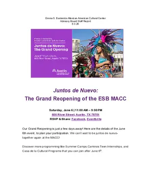
Emma S. Barrientos Mexican American Cultural Center Advisory Board Staff Report 6.3.26 Juntos de Nuevo: The Grand Reopening of the ESB MACC Saturday, June 6 | 11:00 AM – 9:00 PM 600 River Street, Austin, TX 78701 RSVP & Share: Facebook, Eventbrite Our Grand Reopening is just a few days away! Here are the details of the June 6th event, to plan your participation. We can’t wait to be juntos de nuevo- together again at the MACC! Discover more programming like Summer Camps,Caminos Teen Internships, and Casa de la Cultural Programs that you can join after June 6th. Sign up to Volunteer Help make this event even better! Volunteer on June 5th (setup) or June 6th (multiple shift options). Volunteers will have access to staff break areas and a look behind the scenes! Help us make MACC history! Create a quick givepulse profile to track your volunteer hours! Austintexas.gov/macc/grand- reopening Arrival & Parking Address is 600 River Street, at the intersection of Rainey Street and River Street. There are multiple walk-in entrances, marked with red arrows The ESB MACC parking lot will be closed to the public from Thursday, June 4th to midnight on Saturday, June 6th. There is no public parking on-site for the Grand Reopening on June 6th. Parking is free in the Holly Street neighborhood. Parking is also available at downtown garages including the Austin Convention Center Parking Lot. There will be a free shuttle bus from the Sanchez Elementary and Metz Elementary to the ESB MACC and back from 10:30am-10:00pm. Please look for the "shuttle stop" signs at these locations. You can take the shuttle even if you don’t park in the actual school parking lots. Ridesharing and public transit encouraged. Drop off at the traffic circle. Bicycle parking is available on site. Bring your bike lock! The June 6th Reopening coincides with the reopening of the Waterloo Greenway Confluence. Park once, and attend both events! Workshop Schedule View our new and renovated spaces and cool off inside! Bellow is a list of our activations and event partners. If you want to take a guided tour, meet at the purple MACC tent at 12:00, 12:30, 1:00, or 1:30pm. MACC staff will be giving these tours alongside the architects Miro Rivera. You can also pick up a self- guided tour at the MACC tent put together by Cassie Smith and the MACC Education Department. Dance Studio (1st …
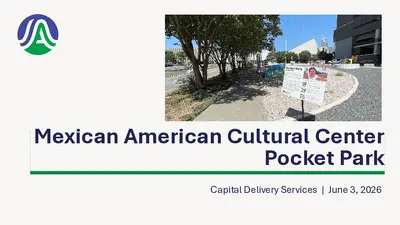
Mexican American Cultural Center Pocket Park Capital Delivery Services | June 3, 2026 MACC Pocket Park 60 Rainey Street Gateway to the Mexican American Cultural Center Approx 7,400 sq ft Approved for AIPP mural 2 MACC Pocket Park • Temporary park improvements installed Spring 2024 with donated benches. • Rotation list selection of Freese & Nichols for Design Services December 2025. • Proposal for services submitted May 06, 2026 was out-sized for the project • COA design with ESD Team lead by Landscape Architect Kimberly Gilbertson • Project focus on landscape and mural. Additional exhibitory components will be addressed at a future phase. 3 Landscape Architecture by ESD • Violet Crown Trail South Whirlpool Patio • Mokan / Bolm Road Trailhead • BOLM / Shady / Airport AIPP Colab • East MLK AIPP Colab 4 Anticipated Timeline MACC Pocket Park Planning: Summer 2026 Consultant selection 2026 Bid/Award: Fall 2027 Advertising, Bidding and Award 2028 2027 Design: Fall 2026 to Summer 2027 Design and Permitting Construction: Fall 2027 to Summer 2028 Construction 5
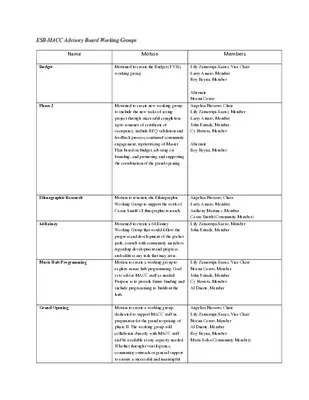
ESB-MACC Advisory Board Working Groups Name Motion Members Budget Phase 2 Ethnographic Research 64 Rainey Music Hub Programming Grand Opening Motioned to create the Budget (FY26) working group. Lily Zamarripa-Saenz, Vice Chair Larry Amaro, Member Roy Reyna, Member Alternate Noemi Castro Angelica Navarro, Chair Lily Zamarripa-Saenz, Member Larry Amaro, Member John Estrada, Member Cy Herrera, Member Alternate Roy Reyna, Member Motioned to create new working group to include the new tasks of seeing project through successful completion up to issuance of certificate of occupancy, include RFQ validation and feedback process, continued community engagement, reprioritizing of Master Plan based on budget, advising on branding, and promoting and supporting the coordination of the grand opening. Motion to reinstate the Ethnographic Working Group to support the work of Cassie Smith’s Ethnographic research. Motioned to create a 64 Rainey Working Group that would follow the progress and development of the pocket park, consult with community members regarding development and progress, and address any task that may arise. Motion to create a working group to explore music hub programming. Goal is to advise MACC staff as needed. Purpose is to provide future funding and include programming to buildout the hub. Motion to create a working group dedicated to support MACC staff in preparation for the grand reopening of phase II. The working group will collaborate directly with MACC staff and be available at any capacity needed. Whether through event logistics, community outreach or general support to ensure a successful and meaningful Angelica Navarro, Chair Larry Amaro, Member Anthony Martinez, Member Cassie Smith (Community Member) Lily Zamarripa-Saenz, Member John Estrada, Member Lily Zamarripa-Saenz, Vice Chair Noemi Castro, Member John Estrada, Member Cy Herrera, Member Al Duarte, Member Angelica Navarro, Chair Lily Zamarripa-Saenz, Vice Chair Noemi Castro, Member Al Duarte, Member Roy Reyna, Member Maria Solis (Community Member) Hector Ordaz (Community Member) Awards of Excellence (AOE) Strategic Planning and Partnership reopening that reflects the culture and communities’ significance. Including consulting community members as needed and inviting them to meetings for public comment. Motioned to reestablish the Awards of Excellence Working Group to discuss nominations for 2026 awardees, selection committee, assistance with event planning, and details of set up and breakdown to provide support for MACC staff. Motion to create a Strategic Planning and Partnership Working Group to strengthen the long-term sustainability, visibility, and impact of the Cultural Center by guiding strategic direction and cultivating high-value partnerships Core …
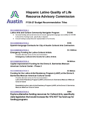
Hispanic Latino Quality of Life Resource Advisory Commission FY26-27 Budget Recommendation Titles RECOMMENDATION 1: Latino Arts and Culture Community Navigator Program $125K ● Increase funding and social resources to ensure appropriate language accessibility for AACME Cultural Arts Funding Cycle, specifically in Spanish ● Ensure funding is proportional to representation of community RECOMMENDATION 2: Spanish-language Contracts for City of Austin Cultural Arts Contractors $10K RECOMMENDATION 3: Emergency Funding for Latino Cultural Artists Possible alternate names for the recommendation: Emergency Cultural Arts Grants for Latino Artists $1.5 Million RECOMMENDATION 4: Capital Improvement Funding for the Emma S. Barrientos Mexican American Cultural Center - Phase 2 $6 Million RECOMMENDATION 5: $1 Million Funding for the Latino Artist Residency Program (LARP) at the Emma S. Barrientos Mexican American Cultural Center Possible alternate names for the recommendation: Latino Artist Residency Program (LARP) at the Emma S. Barrientos Mexican AMerican Cultural Center Reestablishing the Latino Artist Residency Program (LARP) at the Emma S. Barrientos Mexican AMerican Cultural Center RECOMMENDATION 6: Explore alternative funding resources for Cultural Arts, specifically state legislation that would increase the 15% HOT Tax fund cap for funding programs $50K BOARD / COMMISSION RECOMMENDATION Hispanic/Latino Quality of Life Resource Advisory Commission Recommendation Number: (20260324-XXX) Latino Arts & Cultural Community Navigator Program WHEREAS, approximately 32% of Austin’s population identifies as Hispanic or Latino 1; and WHEREAS, 31% of Austinites speak a language other than English at home, with Spanish the predominant language spoken in the City 2; and WHEREAS, Austin has a long history of systemic racism and racial inequity that continues today. Throughout history, communities of color have been excluded, marginalized, and discriminated against as a result of City policies and practices. This history was reinforced by segregationist policies throughout the 20th century affecting a range of Austin venues, including schools, public parks, and commercial businesses, among others, and WHEREAS, Spanish-speaking cultural arts organizations and individual artists continue to face inequitable access to Cultural Arts resources and services as a result of systemic and racial inequity, but also due to evolving City policies and the implementation of new procedures that fail to be culturally responsive and do not adequately address language access; and WHEREAS, The City of Austin’s Latino and Spanish-speaking community continues to voice the need for culturally-sensitive assistance, including and not limited to: 1. Application navigation 2. Access to Spanish-language contracts and grant agreements 3. Accurate, culturally competent Spanish translations of …
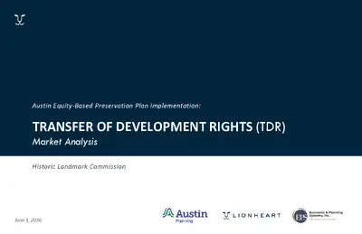
REGULAR MEETING OF THE HISTORIC LANDMARK COMMISSION WEDNESDAY, JUNE 3, 2026, AT 6:00 P.M. CITY HALL, COUNCIL CHAMBERS 301 W. 2ND STREET AUSTIN, TEXAS Some members of the Historic Landmark Commission may be participating by videoconference. The meeting may be viewed online at: http://www.austintexas.gov/page/watch-atxn-live Public comment will be allowed in-person or remotely via telephone. Speakers may only register to speak on an item once either in-person or remotely and will be allowed up to three minutes to provide their comments. Registration no later than noon the day before the meeting is required for remote participation by telephone. To register to speak remotely, please use the QR code or link at the end of this document. For questions, please email preservation@austintexas.gov. CURRENT COMMISSIONERS BEN HEIMSATH, CHAIR (D-8) CARL LAROSCHE (D-6) ROXANNE EVANS, VICE CHAIR (D-2) VACANT (D-10) JEFFREY ACTON (MAYOR) TONYA PLEASANT-WRIGHT (D-1) JAIME ALVAREZ (D-7) JUDAH RICE (D-4) HARMONY GROGAN (D-5) BAT TANIGUCHI (D-9) KEVIN KOCH (D-3) AGENDA CALL TO ORDER PUBLIC COMMUNICATION: GENERAL The first 10 speakers signed up prior to the meeting being called to order will each be allowed a three- minute allotment to address their concerns regarding items not posted on the agenda. APPROVAL OF MINUTES 1. Approve the minutes of the Historic Landmark Commission regular meeting on May 6, 2026. BRIEFINGS 2. 3. 4. Briefing regarding updates on the project at 1010 E. Cesar Chavez St. by Ingrid Gonzalez Featherston, AIA, Senior Architect, MF Architecture. Transfer of Development Rights Market Analysis Briefing by Cara Bertron, Program Manager II, Austin Planning; Kevin Howard Oliver, Project Manager; Abby Gillfillan, Principal, Lionheart; Darin Smith, Principal, EPS. Briefing on the East Austin Historic Resources Survey by Dr. Tara Dudley, Consultant, HHM & Associates. PUBLIC HEARINGS/DISCUSSION ITEMS Historic Landmark and Local Historic District Applications 5. 6. PR-2026-008188 – 1005 E. 8th St. Robertson/Stuart & Mair Local Historic District Council District 1 Proposal: Demolish a contributing building. (Postponed by applicant on May 6, 2026) Applicant: Robbie MacGregor City Staff: Austin Lukes, Historic Preservation Office, 512-978-0766 Staff Recommendation: Postpone the public hearing to the July 1, 2026 Historic Landmark Commission meeting and invite the applicant to the June 10, 2026 meeting of the Architectural Review Committee to discuss alternatives to demolition. HR-2026-021800 – 1107 W. 9th St. Castle Hill Local Historic District Council District 9 Proposal: Remodel a contributing house. (Postponed by applicant on May 6, 2026) Applicant: Nathan Griffith City Staff: …
REGULAR MEETING OF THE HISTORIC LANDMARK COMMISSION WEDNESDAY, MAY 6, 2026, AT 6:00 P.M. CITY HALL, COUNCIL CHAMBERS 301 W. 2ND STREET AUSTIN, TEXAS Some members of the Historic Landmark Commission may be participating by videoconference. The meeting may be viewed online at: http://www.austintexas.gov/page/watch-atxn-live CURRENT COMMISSIONERS X BEN HEIMSATH, CHAIR (D-8) X CARL LAROSCHE (D-6) AB ROXANNE EVANS, VICE CHAIR (D-2) X TREY MCWHORTER (D-10) X JEFFREY ACTON (MAYOR) X TONYA PLEASANT-WRIGHT (D-1) X JAIME ALVAREZ (D-7) X JUDAH RICE (D-4) AB HARMONY GROGAN (D-5) X BAT TANIGUCHI (D-9) X KEVIN KOCH (D-3) DRAFT MINUTES CALL TO ORDER: 6:01PM PUBLIC COMMUNICATION: GENERAL The first 10 speakers signed up prior to the meeting being called to order will each be allowed a three- minute allotment to address their concerns regarding items not posted on the agenda. Meghan King Namour gave updates on Preservation Austin. APPROVAL OF MINUTES 1. Approve the minutes of the Historic Landmark Commission regular meeting on April 1, 2026. MOTION: Approve the minutes per passage of the consent agenda, on a motion by Commissioner Larosche. Commissioner Acton seconded the motion. Vote 9-0. The motion passed. BRIEFINGS 2. 3. Staff briefing on 1207 W. 45th St. regarding administrative approval of religious-owned property per State law by Kalan Contreras, Planner Principal, Historic Preservation Office, Austin Planning. Briefing regarding future plans for 916 Congress Ave. by Patrick Georgiou, Project Manager, Build Austin TX. PUBLIC HEARINGS/DISCUSSION ITEMS Historic Landmark and Local Historic District Applications 4. 5. PR-2026-008188 – 1005 E. 8th St. – POSTPONED BY APPLICANT Robertson/Stuart & Mair Local Historic District Council District 1 Proposal: Demolish a contributing building. (Postponed by applicant on April 1, 2026) Applicant: Robbie MacGregor City Staff: Austin Lukes, Historic Preservation Office, 512-978-0766 Staff Recommendation: Grant the applicant-requested postponement to the June 3, 2026 Historic Landmark Commission meeting. MOTION: Postpone the public hearing to June 3, 2026 meeting per passage of the consent postponement agenda, on a motion by Commissioner Rice. Commissioner McWhorter seconded the motion. Vote 9-0. The motion passed. HR-2026-021800 – 1107 W. 9th St. – POSTPONED BY APPLICANT Castle Hill Local Historic District Council District 9 Proposal: Remodel a contributing house. (Postponed by applicant on April 1, 2026) Applicant: Nathan Griffith City Staff: Kalan Contreras, Historic Preservation Office, 512-974-2727 Staff Recommendation: Approve the Certificate of Appropriateness once revised drawings are submitted. The applicant has agreed to implement Architectural Review Committee feedback. MOTION: Postpone the …
Austin Equity-Based Preservation Plan Implementation: TRANSFER OF DEVELOPMENT RIGHTS (TDR) Market Analysis Historic Landmark Commission June 3, 2026 The Why Council Direction: Comprehensively reform Austin's historic tax incentive program to advance equity and align with specific recommendations in the Equity-Based Preservation Plan, including Transfers of Development Rights. (Resolution 20230323-059, Resolution 20241121-078 Motion Sheet #1) Downtown Austin Plan: Establish a Transfer of Development Rights system to allow Warehouse District property owners to sell unused floor area to property owners seeking greater density in other parts of Downtown. (Adopted 2011) Equity-Based Preservation Plan: Actively explore how a Transfer of Development Rights program could successfully support preservation of smaller-scale downtown buildings, commercial corridors, and historic districts in areas targeted for higher density. (Adopted Nov. 2024 as part of Imagine Austin Comprehensive Plan) What is Transfer of Development Rights (TDR)? How It Works • Voluntary, market-based tool • The owner of a protected property (sending site) sells unused development capacity • The developer (receiving site) purchases additional development capacity for a new building Sending Sites are properties the City wants to protect, such as historic landmarks. Receiving Sites are properties in areas targeted for higher population density and growth. Receiving Site Sending Site Sending Site Source: NYU Furman Center TDR & Density Bonus Programs Considerations for Integration • Similar areas, different scales • Affordability should remain a priority • Setting a maximum allowable height would provide predictability for developers and neighbors • Further analysis and refinement are critical to ensure that any future TDR program complements density bonus programs Example Receiving Zones + TDR + Density Bonus + By-Right = Maximum Allowable Height TDR Project Timeline 5 2 0 2 . v o N 6 2 0 2 . n a J Research & Analysis Technical Analysis Engagement 6 2 0 2 h c r a M 6 2 0 2 l i r p A 6 2 0 2 e n u J We Are Here Program Structure 6 2 0 2 y l u J Final Report Survey & Focus Group Housing & Planning Committee Historic Landmark Commission Council Memo 1 2 3 4 TDR Stakeholder Committee Review TECHNICAL ANALYSIS Technical Analysis Study Areas Potential Sending Zones Example Receiving Zones Scale of TDR Supply Potential Sending Parcels 447 parcels may qualify as sending sites Sending Zone Historic Landmarks Eligible Landmarks E 11th & 12th St E Cesar Chavez & E 6th St …
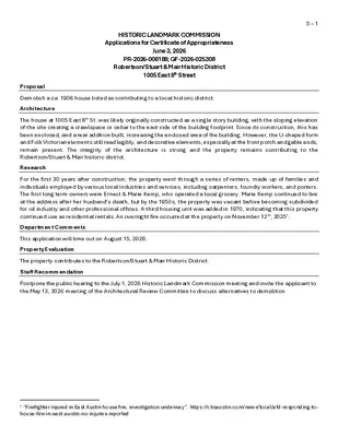
HISTORIC LANDMARK COMMISSION Applications for Certificate of Appropriateness June 3, 2026 PR-2026-008188; GF-2026-025308 Robertson/Stuart & Mair Historic District 1005 East 8th Street 5 – 1 Proposal Demolish a ca. 1906 house listed as contributing to a local historic district. Architecture The house at 1005 East 8th St. was likely originally constructed as a single story building, with the sloping elevation of the site creating a crawlspace or cellar to the east side of the building footprint. Since its construction, this has been enclosed, and a rear addition built, increasing the enclosed area of the building. However, the U-shaped form and Folk Victorian elements still read legibly, and decorative elements, especially at the front porch and gable ends, remain present. The integrity of the architecture is strong and the property remains contributing to the Robertson/Stuart & Mair historic district. Research For the first 30 years after construction, the property went through a series of renters, made up of families and individuals employed by various local industries and services, including carpenters, foundry workers, and porters. The first long term owners were Ernest & Marie Kemp, who operated a local grocery. Marie Kemp continued to live at the address after her husband’s death, but by the 1950s, the property was vacant before becoming subdivided for oil industry and other professional offices. A third housing unit was added in 1970, indicating that this property continued use as residential rentals. An overnight fire occurred at the property on November 12th, 20251. Department Comments This application will time out on August 15, 2026. Property Evaluation The property contributes to the Robertson/Stuart & Mair Historic District. Staff Recommendation Postpone the public hearing to the July 1, 2026 Historic Landmark Commission meeting and invite the applicant to the May 13, 2026 meeting of the Architectural Review Committee to discuss alternatives to demolition. 1 “Firefighter injured in East Austin house fire, investigation underway”. https://cbsaustin.com/news/local/afd-responding-to- house-fire-in-east-austin-no-injuries-reported Location Map 5 – 2 Property Information Photos 5 – 3 Texas Historical Commission, photograph, May 29, 1975. The Portal to Texas History. Google Streetview, 2024 5 – 4 Site visit, showing fire damage (see backup for additional photos), May 2026 Occupancy History City Directory Research, March 2026 1959 1957 1955 1952 1949 1947 1944 1941 1939 1935 1932 1929 1927 1924 Offices: Norman Texas Company; Roche Oil Company; Pierre Aubuchon, engineer; Hamco Oil & Drilling Vacant Vacant Joseph & Maria Tamayo, owners; painter …
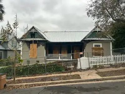
6 – 1 HISTORIC LANDMARK COMMISSION Applications for Certificates of Appropriateness June 3, 2026 HR-2026-021800 Castle Hill Historic District 1107 West 9th Street Proposal Renovate existing house. The non-contributing rear house will also be modified. Project Specifications 1) Replace existing siding with painted wood lap siding. 2) Construct new 8’0” steel fence. 3) Replace existing windows. 4) Construct rear addition with dormer. 5) Remove chimney from east dormer. 6) Replace existing roof. Architecture A 2010 historic zoning application describes the building as follows: The house is one-and-a-half stories with a hipped roof, hipped dormers, and a wraparound porch…Above the front door there is a transom, an integral part of architecture of the period as well…The house still has 7 working transoms throughout the inside, which helped to circulate the air between rooms…The house has had a number of changes over the years. The house first appears on the 1922 Sanborn Fire Insurance Company map and shows a smaller footprint…[it] had a porch stretching all the way across the front of the house and another one along the east side. …Between 1922 and 1935, design of the house was modified to include a bay window, extend the sides and include a small porch in the middle of the back of the house. In 1962 the house was modified again — the bay window was brought forward a few feet onto the porch to create a larger living room inside — which eliminated the front porch in front of this window, and the back part of the side porch was enclosed to enlarge the bedroom. In 2008 the kitchen…was extended slightly to the rear…In 2010 the front porch was restored to again extend all the way across the front of the house (and free one of the original porch pillars from the wall built in 1962) by moving a modified version of the bay window back (Tim Cuppett was also the architect for this project). All of the finishes and details on the outside of the house are original with the exception of the new bay window.1 However, former Historic Preservation Officer Steve Sadowsky noted that the 2010 addition likely destroyed original fabric at the front of the house: The house had a projecting canted bay on the right side of the façade, which staff believes was original to the house in form, despite depictions on historical Sanborn Fire Insurance Company maps. …
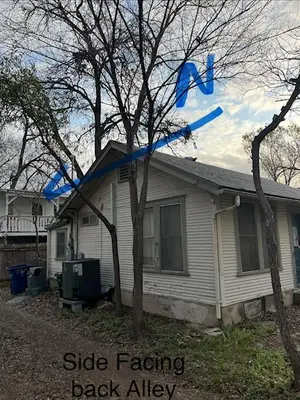
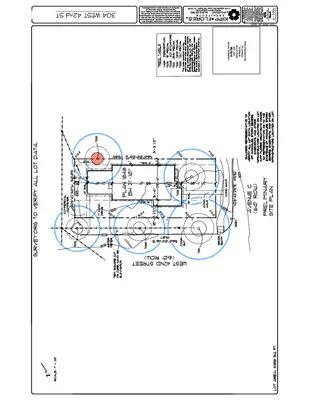
HISTORIC LANDMARK COMMISSION Applications for Certificates of Appropriateness June 3, 2026 HR-2026-036164 Hyde Park Local Historic District 304 West 42nd Street 7 – 1 Proposal Demolish a contributing building and replace it with a new building. Project Specifications The proposed new building spans two lots and is oriented towards Avenue C rather than West 42nd Street. It is two stories in height, clad in horizontal lap siding with board and batten accents. The roof is composed of a series of compound gables and a shed-roof dormer at the southern elevation. A partial-width covered porch displays Craftsman-inspired proportions and triangular brackets at the 42nd Street elevation; similar brackets appear at gable ends on the Avenue C façade and at the westernmost carport elevation. Fenestration includes fixed, casement, and 1:1 windows interspersed throughout each elevation. Architecture 304 West 42nd Street is a ca. 1932 bungalow. It is one story in height, clad in horizontal wood siding, with simple massing and a side-gabled rectangular plan. A gabled garage abuts the easternmost elevation. Fenestration includes 1:1 wood windows. Exposed rafter tails are present at eaves and triangular brackets at gable ends. Design Standards The Hyde Park Design Standards are used to evaluate projects within the historic district. The following standards apply to the proposed project: 1. General Standards 1.1: Prevention of Demolition. Demolition of any contributing structure is strongly discouraged under all circumstances. The proposed project includes demolition of a contributing building. 5. Residential Standards: New Construction of Single-Family Structures 5.1: Massing, Scale, and Architectural Elements. Use massing, scale, and architectural elements typical of the contributing buildings on the block when designing a new building. The geometry of new house construction shall be in a scale with contributing buildings on the same block. When applying to Historic Landmark Commission, include photographs of all existing adjacent buildings and any other buildings on the block which have inspired design choices for the new construction. Proposed massing is more complicated than contributing buildings nearby, though the new building reflects historic-era gable forms. The building’s location, with the main entrance fronting Avenue C and the long secondary side along 42nd, is not consistent with the streetscape; however, the secondary entrance and gabled porch somewhat mitigate this. 5.3: Porches. Front porches on new construction are not necessary, but if present, they must be at least 7 feet deep. The proposed porch is approximately 5.25’ at the 42nd Street elevation …
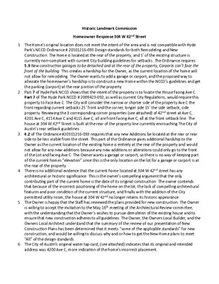
Historic Landmark Commission Homeowner Response 304 W 42nd Street 1. The Home’s original location does not meet the intent of the area and is not compatible with Hyde Park’s NCCD Ordinance # 20101216-093 Design standards for both Remodeling and New Construction. The Home is located at the rear of the property, and 5’ of the existing structure is currently non-compliant with current City building guidelines for setbacks. The Ordinance requires 5.9 New construction garages to be detached and at the rear of the property, Carports can’t face the front of the building. This creates a hardship for the Owner, as the current location of the home will not allow for remodeling. The Owner wants to add a garage or carport, and the proposed way to alleviate the homeowner’s hardship is to construct a new Home within the NCCD’s guidelines and get the parking (carport) at the rear portion of the property. 2. Part 7 of Hyde Park NCCD shows that the intent of the property is to locate the House facing Ave C. Part 7 of The Hyde Park NCCD # 2009423-092, as well as current City Regulations, would require this property to Face Ave C. The City will consider the narrow or shorter side of the property Ave C the front regarding current setbacks 25’ front and the corner, longer side 15’ the side setback, side property. Reviewing the 3 corresponding corner properties (see attached) of 42nd street at Ave C, 4201 Ave C, 4114 Ave C and 4115 Ave C, all are front facing Ave C, all at the front setback line. The house at 304 W 42nd Street is built at the rear of the property line currently encroaching The City of Austin’s rear setback guidelines. 3. 4.2 of The Ordinance #20101216-093 requires that any new Additions be located at the rear or rear side to be less visible from the street. This part of the Ordinance gives additional hardship to the Owner as the current location of the existing home is entirely at the rear of the property and would not allow for any new additions because any new additions or alterations could only go to the front of the Lot and facing Ave C. The Owner wants a garage or carport, so there is no way of keeping part of the current homes “elevation” since this is the only location on the lot for a …
HISTORIC LANDMARK COMMISSION Applications for Certificate of Appropriateness June 3, 2026 HR-2026-057184 Aldridge Place Historic District 208 West 32nd Street 8 – 1 Proposal Relocate a contributing property on the same lot and construct a two-story addition, along with a detached garage. Project Specifications 1) Rotate an existing 1,382 square foot contributing resource on its existing site to allow it to fit within setback requirements. 2) Demolish a rear corner and side wall, along with a portion of the front wall and porch. In its place, construct an addition to the rear of the existing house, along with a second story that encompasses a portion of the existing house’s footprint. 3) Demolish the existing rear garage and construct a new garage in its place. Architecture This property is a single-story, largely symmetrical house that contributes to the Aldridge Place historic district. It features a deep front porch that is located at the center of the front elevation facing 32nd Street. Though it is on a corner lot, and many such properties in the district face Hemphill Park or otherwise open up to both streets, this house does not. There are several sets of paired wood windows on the front and sides of the house. One is found immediately adjacent to the front door, and two are located towards the rear of the Hemphill Park side. Windows are either 1-over-1 or 4-over-1 fixtures, which may indicate some replacement over time. The house is set on pier and beam foundation, and brick posts appear at the bottom half of the front porch supports. The roof is standing seam metal in material. Overall, the house is in a threatened condition due to years of neglect and likely requires foundation shoring and reinforcement. Design Standards The Aldridge Place Design Standards are used to evaluate projects within the historic district. The following standards apply to the proposed project: General Standards 5.1.1. Prevention of Demolition This application seeks to avoid total demolition, but does significantly alter the contributing property to the point that it will be read very differently from the street. While the street facing facades will be largely left intact, the two rear walls will see significant removal of historic material. 5.1.2. Retention of Historic Style While the existing style of the building is largely being retained, there are some features that are proposed to be removed from the 32nd Street elevation, such as …
WEST 32ND ADDITION M P 8 1 : 8 3 : 5 6 2 0 2 / 6 / 5 WEST 32ND ADDITION HLC SUBMISSION 1 FULL SCALE IS 24X36 SHEET | HALF SCALE IS 12X18 SHEET 208 WEST 32ND STREET AUSTIN, TX 78705 SD-000 05.07.2026 SURVEY NOT TO SCALE M P 8 1 : 8 3 : 5 6 2 0 2 / 6 / 5 WEST 32ND ADDITION HLC SUBMISSION 1 FULL SCALE IS 24X36 SHEET | HALF SCALE IS 12X18 SHEET 208 WEST 32ND STREET AUSTIN, TX 78705 SD-100 05.07.2026 SITE CONDITIONS EXISTING HOUSE SOUTH ELEVATION WEST ELEVATION NORTH ELEVATION EAST ELEVATION M P 1 2 : 8 3 : 5 6 2 0 2 / 6 / 5 WEST 32ND ADDITION HLC SUBMISSION 1 FULL SCALE IS 24X36 SHEET | HALF SCALE IS 12X18 SHEET 208 WEST 32ND STREET AUSTIN, TX 78705 SD-101 05.07.2026 SITE CONDITIONS EXISTING GARAGE SOUTH ELEVATION WEST ELEVATION NORTH ELEVATION EAST ELEVATION M P 2 2 : 8 3 : 5 6 2 0 2 / 6 / 5 WEST 32ND ADDITION HLC SUBMISSION 1 FULL SCALE IS 24X36 SHEET | HALF SCALE IS 12X18 SHEET 208 WEST 32ND STREET AUSTIN, TX 78705 SD-102 05.07.2026 SITE CONDITIONS EXISTING INTERIORS M P 4 2 : 8 3 : 5 6 2 0 2 / 6 / 5 WEST 32ND ADDITION HLC SUBMISSION 1 FULL SCALE IS 24X36 SHEET | HALF SCALE IS 12X18 SHEET 208 WEST 32ND STREET AUSTIN, TX 78705 SD-103 05.07.2026 SITE CONDITIONS EXISTING DETAILS EXPOSED RAFTER TAILS CORNER EXPOSED RAFTER TAILS EAVE COLUMN AT CORNERS ATTIC WINDOW ATTIC VENT AND TRIM EXTERIOR WINDOW SCREEN EXTERIOR WINDOW TRIM EXTERIOR COLUMN BASE EXTERIOR FIREPLACE TEARDROP SIDING INTERIOR CORNER WINDOW M P 8 2 : 8 3 : 5 6 2 0 2 / 6 / 5 WEST 32ND ADDITION HLC SUBMISSION 1 FULL SCALE IS 24X36 SHEET | HALF SCALE IS 12X18 SHEET 208 WEST 32ND STREET AUSTIN, TX 78705 SD-104 05.07.2026 SITE PLAN_EXISTING EXISTING HOUSE ORIENTATION HEMPHILL PARK 43' R.O.W. N 35° 26' 13" 16.38' E N 39° 42' 32" 16.35' E N 44° 16' 10" 16.35' E N 36° 05' 41" 16.30' E N 40° 52' 52" 16.35' E N 45° 47' 02" 16.45' E N 45° 54' 04" 32.02' E 25 YEAR FLOOD PLAIN (576.78') 2 5' S E T B A C K EXG. PORCH: 154 SF EXG. …
HISTORIC LANDMARK COMMISSION Applications for Certificate of Appropriateness June 3, 2026 HR-2026-058442 Webster House 706 Oakland Avenue 9 – 1 Proposal Make several alterations to a landmarked building. Project Specifications 1) Perform several work items at a landmarked building, which has been altered in various stages since original construction. These alterations include: a. Constructing a driveway b. Changing out a basement door c. Cladding non-historic metal columns d. Removal of an inappropriate stairwell enclosure e. Construction of two gable dormers f. Removal of a small exterior storage room Architecture While City of Austin landmarks have typically been designated with their original architectural design largely intact, the Webster House saw numerous small alterations after its 1916 construction and before its 2009 landmark designation. These include an enclosed porch at the northeast (the most prominent corner) and several small additions, some of which are very visually prominent on the house (for example, a narrow stairwell enclosure can be found above the enclosed porch, near the front of the house. These cumulative changes have made it somewhat difficult to understand what was the original building. Design Standards The City of Austin’s Historic Design Standards (March 2021) are based on the Secretary of the Interior’s Standards for Rehabilitation and are used to evaluate projects at historic landmarks. The following standards apply to the proposed project: Repair and alterations 1. General standards Material proposed to be demolished is understood to be from after original construction. Generally, historic wall and roof systems that touch these sections to be removed will be retained and patched with matching materials. 2. Foundations A basement door entryway is proposed at the front of the existing concrete skirt, which is full height due to grade changes on site. It is highly recommended that the applicant consider where, if possible, this doorway may be installed in a more discreet location. 3. Roofs Several alterations will be made to the roofline, largely in service of removing non-historic material. However, two dormers are proposed above the enclosed porch to provide light to the second floor playroom. The material for the roofs of these dormers are not disclosed, but they must be compatible with the existing roof around it. 4. Exterior walls and trim Drawings indicate that any areas where non-original walls will be removed will be patched with materials similar to the original. If those exact products have not been identified, the applicant must …
Webster House Design Narrative Webster House Design Narrative to accompany Historic Review Application to accompany Historic Review Application 5.8.2026 5.8.2026 Marcus McKenzie Marcus McKenzie Hush House Hush House mem@hush.house mem@hush.house 1) Driveway Proposed Work Install a new driveway onto property for the house's first off-street parking. Also includes retaining walls and terraced garden spaces. Location of Proposed Work Front yard (east) and side yard (south) facing Oakland Ave. Proposed Materials Concrete driveway, stone retaining wall (main) and low natural steel wall 2) Basement Door Proposed Work Interior basement finish-out includes one exterior change. A new door accessing the new driveway. The door will match the house's original Craftsman-style doors. Location of Proposed Work Ground floor basement, facing Oakland Ave., partially concealed by landscape edge. Proposed Materials Stained wood + glass 3) Post Cladding Proposed Work Clad the existing galvanized steel canopy columns with wood trim to match house's trim. Location of Proposed Work South side, small deck, top of hill Proposed Materials Stained wood Webster House Design Narrative 1 of 2 4) Remove Inappropriate Stairwell Proposed Work Remove the narrow, hip-roofed sideward-facing stairwell, to clarify house massing. New stair to be located more internally towards the house center. Replace with roof to match existing adjacent roofs Location of Proposed Work Top of second floor walls at roof, inside corner facing toward street intersection Proposed Materials Standing seam metal roof to match existing. 5) Gable Dormers Proposed Work Install new gabled dormers to better match existing house gables, achieve more appropriate massing with the house, and apply the design “rule of three”. Location of Proposed Work Roof adjacent to second floor playroom. Proposed Materials Wood siding (likely pine #117) and standing seam metal roof to match existing. 6) Remove Storage Room Proposed Work Remove the small storage room visible to Tremont St. Location of Proposed Work Northwest / back-right corner of house Proposed Materials Patch with matching existing materials as needed. Webster House Design Narrative 2 of 2 highland ave tremont st. oakland ave Webster House Property Intro • The Webster House sits at the southwest intersection of Oakland Ave. and Tremont St. in Tarrytown, what was once the west end of Austin. • The house accepted an Historic Landmark designation in 2008 under zoning case # C14H-2009-0023 • Original house was built in 1921. Numerous additions have taken place throughout the years, from 1935 to 2000. • Although the front …
HISTORIC LANDMARK COMMISSION Applications for Certificate of Appropriateness June 3, 2026 HR-2026-056957 Rogers Washington Holy Cross Historic District 2006 Maple Avenue 10 – 1 Proposal Demolish a rear, non-original addition at a contributing property, and construct a new addition in a similar location. Project Specifications 1) Demolish the rear portion of the property behind what is understood to be the original structure on the site, which is a two-bedroom section and rectangular in form. This front section will be retained. 2) Construct a new rear addition behind the original house that will connect only where the above demolition occurs. Addition will be a single-story, rectangular in plan, and will not exceed the width of the original house footprint. 3) Alter the driveway to terminate near the original house and construct a carport. Existing curb cut location will be retained. Architecture The existing building at 2006 Maple Avenue is a single-story, rectangular structure that is set above grade at its front and accessed by a concrete stair, which leads to a front porch facing the street. The house is clad on all sides by tile siding, though the exact material is unknown. To the left of the front door is a set of paired, 1-over-1 windows, and to the right is a large picture window overlooking the street. To the rear of the property, the house extends beyond the rectangular footprint towards the northwest, which was once a garage that has since been enclosed. Though the house does not feature many stylistic embellishments, it fits well with the form, scale, and experience of other contributing properties in the Rogers Washington Holy Cross neighborhood, for which it is a contributing property. Design Standards The Rogers Washington Holy Cross Design Standards are used to evaluate projects within the historic district. The following standards apply to the proposed project: General Standards 1. Protected Facades The front and sides of the originally constructed building are to be retained. Siding material on this portion of the building is to be replaced, due to deterioration and the possibility of hazardous materials present. The application lists the new material as “New Hardie Siding,” but it is highly recommended that, when a specific product is selected, that information is shared with the Historic Preservation Office staff to ensure it is an accurate and appropriate match to existing material. Additionally, a stone material cladding is proposed at the existing concrete …
HISTORIC LANDMARK COMMISSION Applications for Permits in National Register Historic Districts June 3, 2026 PR-2026-053766 Old West Austin Historic District 3304 Oakmont Boulevard 11 – 1 Proposal Construct a rear addition and new front porch at a contributing property. Project Specifications 1) Construct a rear addition, held within the existing sides of the house. 2) Construct a front porch where there is currently only a concrete stair, as well as construct a covered porch roof not to exceed the width of the house. 3) Convert the existing garage into conditioned space and infill the existing garage door. Architecture This ca. 1950 house is a single-story and clad in buff colored brick. The main entry door faces the street at the center of the front facade. To one side, an attached single car garage appears to be original or constructed soon after the main house. The house is constructed on a raised foundation and there are three concrete stairs that leasd to the front door and a small entry landing. The main structure of the roof is side gabled with a projecting front gable to the left of the front door. Overall, the property isin excellent condition and retains integrity. Research Within the first ten years after its construction, the property had several owners who all lived at the residence for a short time. These included Milton and Idella Browning, the former of which worked in a director role at the State Department of Education, and Scott McGinnis, a self-employed realtor. Design Standards The City of Austin’s Historic Design Standards (March 2021) are based on the Secretary of the Interior’s Standards for Rehabilitation and are used to evaluate projects in National Register districts. The following standards apply to the proposed project: Repair and alterations 4. Exterior walls and trim Where a bathroom is being created within the existing house, a window will be changed out to a smaller unit, with the remainder infilled with matching brick. This will be located at the rear of a side wall, and will not be visually apparent from the street. 8. Attached garages and carports At the attached garage, the applicant plans to convert this space into additional conditioned floor area. The garage door will be removed and the wall infilled with a door, surrounded by horizontal siding to match the material on the side and rear. The City of Austin Historic Design Standards call …
1/2 OF LOT 1 BRYKERWOODS G [S 70° 40' 00" E 111.52'] S 72° 38' 49" E 111.50' AC 5' B.L. 9 . 9 ' 625' TBM 624.16' 21.2' 16.4' 4.9' ) . ' 1 . 9 EXISTING ELECTRICAL METER TO REMAIN ' 1 . 9 NEW COVERED PORCH ' 4 . 6 2 7.9' ' 3 . 7 1 GRAVEL DRIVE 625' CONCRETE APRON CONCRETE PAVERS EXISTING BUILDING TO REMAIN R E T T U G D B A B R U C E T R C N O C ' 8 4 . 3 6 W " 3 5 ' 8 5 ° 6 2 S ] ' . 7 2 3 6 W " 0 0 ' 8 5 ° 8 2 S [ . W O R . ' 0 5 ( D V L B T N O M K A O POWER POLE OVERHEAD ELECTRICAL SERVICE 28" PECAN UNCOVERED DECK 8' X 10' WOOD SHED ON BLOCKS SOUTH 1/2 OF LOT 1 CONCRETE STEPS ' 3 2 6 20" OAK 5 ' . P U E . . 3 . 7 ' 5.8' ' 0 . 7 1 ' 4 . 5 1 NEW ADDITION P P N 2 4 ° 3 7 ' [ N 2 6 ° 3 9 ' 0 0 " E 4 4 . 8 5 ' ] 2 8 " E 4 4 . 8 9 ' 3 T O L CONCRETE WALK CONCRETE STEPS 625' WM 20.1' 25.1' 3.5' ' 8 . 5 1 5.0' ' 9 . 7 E N I L G N D L I U B I ' 5 2 15.8' 29.9' 5' BUILDING LINE ' 8 . 7 N 63° 01' 53" W 108.08' [N 61° 02' 00" W 108.14'] LOT 2 1 PLOT PLAN 1/8" = 1'-0" NORTH jamesgonin.com (512) 626-8321 4/29/2026 2:03:17 PM i e c n e d s e R n e d r u D d v B l t n o m k a O 4 0 3 3 3 0 7 8 7 X T , n i t s u A No. Description Date PLOT PLAN Project Number Date Drawn By Checked By 251118 4/27/2026 JG JG A-100 Scale 1/8" = 1'-0" GENERAL PROJECT NOTES: PROJECT TEAM: LOCATION MAP: OWNER: EMILY DURDEN E-MAIL: PHONE: ARCHITECT: durden.emily@gmail.com 512-585-9574 JAMES GONIN, LLC CONTACT: E-MAIL: PHONE: ADDRESS: …
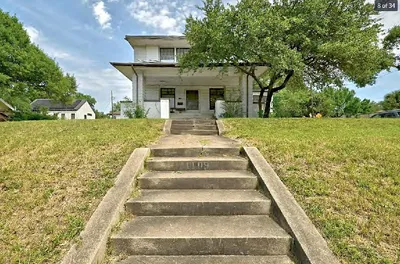
HISTORIC LANDMARK COMMISSION Applications for Permits in National Register Historic Districts June 3, 2026 PR-2026-053670 Travis Heights-Fairview Park Historic District 1109 Travis Heights Boulevard 12 – 1 Proposal Demolish a ca. 1920 house. Architecture This American Foursquare house with Prairie School stylistic influences was constructed around 1920. The two- story house has a low-pitched hipped roof with broad overhangs. The full-width, hipped-roof porch has a long, open span supported at the corners by large square columns. The second floor had recessed corners that been infilled and converted to interior space. Much of the house has been covered with aluminum siding. Wood windows appear throughout the building, with larger, multi-lite fixtures appearing at the front elevation and simpler 1-over-1 units more common at the sides and rear. Research Early owners of this ca. 1920 house were Elmer & Cora Young. E. E. Young was co-owner of an automotive dealership, Hart & Young, Willys-Knight and Overland Austin Agency; he later bought out his partner and continued operation under his name. He served as president of the local automobile dealers’ association. Shortly before his death in 1928, Young became secretary of the Stacy Realty Company, developer of the Travis Heights neighborhood. Later owners included Charles & Katherine Brunner, who owned the house from 1929 until 1947. Charles Brunner operated a jewelry business on East Sixth St. beginning in the late 1890s. After his death in 1933, Katherine Brunner continued to run the jewelry store for another ten years. It appears that she leased out the house following her husband’s death but moved back in around 1941. In the 1950s, the house was occupied by Robert B. and Gwendolyn Hill. Robert Hill was a foreman at the Calcasieu Lumber Company. Department Comments A demolition permit for this property was originally referred to HLC in July 2019, and the case was subsequently withdrawn. Meeting minutes are available here: https://services.austintexas.gov/edims/document.cfm?id=325930. Per city code § 25-11-213 (G)(4), the Historic Landmark Commission has 180 days to review demolition permits in National Register historic districts starting from the date the application was submitted. This period is set to time out on October 27, 2026. Property Evaluation The property contributes to the Travis Heights-Fairview Park National Register district. Designation Criteria—Historic Landmark 1) The building is more than 50 years old. 2) The building appears to retain moderate integrity. 3) Properties must meet two criteria for landmark designation (LDC §25-2-352). Staff …
' 0 0 . 0 0 1 E " 0 0 ' 0 0 ° 0 2 N . R O C F R I M C " 2 / 1 . . E N 5 3 T O L 1/2" IRF BLUE DISK 50.00' S 70° 00' 00" E 1/2" IRF UTILITY POLE 3.2' 1/2" IRF BLUE DISK 0.4' LOT 34 ' 7 . 0 ' 0 . 2 S 70° 00' 00" E 50.00' ' 9 . 4 ' 2 . 0 2 526 24.3' ONE STORY FRAME GARAGE FLOOR= 526.21' 5 2 5 19.4' ' 5 . 0 5.7' 3.4' 6 2 5 5 2 4 3 2 5 525 2.6' EM ' 0 0 . 0 4 1 W " 0 0 ' 0 0 ° 0 2 S LOT 31 ' . 0 0 0 4 1 E " 0 0 ' 0 0 ° 0 2 N LOT 33 TRAVIS HEIGHTS BOULEVARD LOT 32, BLOCK 28 TRAVIS HEIGHTS 525 4 2 5 25' BUILDING LINE 20" OAK 7" GUM 1/2" IRF BLUE DISK 520 523 522 525 524 S 70° 00' 00" E 50.00' (ASSUMED REF. BEARING) 521 520 519 518 517 1/2" IRS 50.00' S 70° 00' 00" E CM 1/2" IRF S.E. COR. LOT 31 W WATER METER W WATER METER TRAVIS HEIGHTS BOULEVARD (80' R.O.W.) TBM SET MAG NAIL ELEV. = 520.72' NOTES: BEARINGS ARE ASSUMED. BUILDING LINES ARE BASED ON THE RECORDED PLAT UNLESS OTHERWISE NOTED. LEGEND: BARBWIRE FENCE CHAINLINK FENCE WROUGHT IRON FENCE WOOD FENCE VINYL FENCE ELECTRIC LINE ASPHALT = CONCRETE = GRAVEL = TILE = WOOD = GM = GAS METER EM = ELECTRIC METER IPF = IRON PIPE FOUND IRS = IRON ROD SET WITH "PREMIER" CAP IRF = IRON ROD FOUND CM = CONTROLLING MONUMENT (WOOD) RAILROAD TIE = STONE = BRICK = LEGAL DESCRIPTION: BEING LOT 32, BLOCK 28, TRAVIS HEIGHTS, AN ADDITION IN TRAVIS COUNTY, TEXAS, ACCORDING TO THE MAP OR PLAT THEREOF RECORDED IN VOLUME 3, PAGE 15, OF THE MAP AND/OR PLAT RECORDS OF TRAVIS COUNTY, TEXAS. SURVEYOR'S CERTIFICATION: THIS IS TO CERTIFY THAT ON THIS DATE A SURVEY WAS MADE ON THE GROUND, UNDER MY SUPERVISION AND REFLECTS A TRUE AND CORRECT REPRESENTATION OF THE DIMENSIONS AND CALLS OF PROPERTY LINES AND LOCATION AND TYPE OF IMPROVEMENTS. THERE ARE NO VISIBLE AND APPARENT EASEMENTS, CONFLICTS, INTRUSIONS OR PROTRUSIONS, EXCEPT AS …
HISTORIC LANDMARK COMMISSION Applications for Demolition and Relocation Permits June 3, 2026 PR-2026-040403 1808 East Cesar Chavez Street 13 – 1 Proposal Demolish a ca. 1930 structure. Architecture The existing structure is a two story commercial structure with two storefront entries side-by-side on the main elevation. There is a small, metal clad awning above the ground floor entryways. Above, two sets of paired, wood- frame windows are present at the second floor, with a moderately pitched hipped roof with exposed rafter tails above. The roof material is metal standing seam, and all exterior walls are clad in thin teardrop siding. While several of the windows are currently boarded over or otherwise inaccessible, images from the past decade would indicate that the existing material is largely intact, if in need of repair. Research This property has a long history of commercial tenants who served the East Austin community. For several decades after construction, it was home to a beauty parlor, a barber shop, and a shoe repair shop. By the 1950s, one or more of these tenants had vacated the building, but there was always at least one occupied storefront at the property. Newspaper records feature advertisements for Smith’s Barber Shop, Guarantee Wave Shop, and Carlson’s Shoe Repair Shop. The latter of these was owned by Reverend E. A. Carlson, formerly a Swedish Baptist minister, for 31 years until his death in 1964. Department Comments Two permits were issued for the property in 1999, though there are no digitized records of the application material. However, summary descriptions are available in city records. One permit described work to remodel the building’s interior & exterior to create a duplex. The second permit from the same year is summarized as, “Add 1st floor stair tower, porch, and 2nd floor extension.” There are no records of this property being surveyed in the 1980 East Austin historic resource survey or the 1984 citywide comprehensive resource survey. At time of writing, no photos of the property can be found prior to the 1999 permits. This application will time out on July 20, 2026. Property Evaluation The 2016 East Austin historic resource survey lists the property as eligible as a City of Austin landmark, as well as contributing to a potential local or National Register historic district. Designation Criteria—Historic Landmark 1) The building is more than 50 years old. 2) The building appears to retain moderate integrity. 3) …
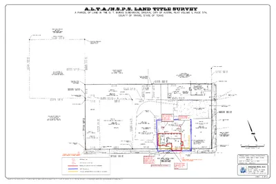
A.L.T.A./N.S.P.S. LAND TITLE SURVEY 2 1 1 2 29" Pecan Tree 20.5" American Elm Tree Buildings & Covered Area to be Demolished LOC: Demolition Erosion Controls: Silt fence or mulch sock, as needed Boundary Boys, LLC
HISTORIC LANDMARK COMMISSION Applications for Demolition and Relocation Permits June 3, 2026 DA-2026-038798 403 Orchard Street 14 – 1 Proposal Demolish a ca. 1912 house, currently used as a business. Architecture This house is a single-story National Folk style building with an inset porch at one corner. The walls are clad in wood tongue and groove siding, and the windows appear to be original wood frames. There is a moderately pitched hipped roof clad in composite shingles. The foundation is pier and beam, with the house slightly elevated above grade. Newspaper records indicate that a permit was issued for two additional rear rooms in 1944, which was the only significant alteration to the building. Research In the first few decades after construction, the occupants of the property were employed in local industries that were situated near the adjacent railroad tracks, including the Austin Transit Company and an ice storage facility. The longest occupants were Leo Payne, who worked as an iceman, and Braulio and Maria Quintanilla, who worked as a cobbler and shoe salesman. They would remain at the address through at least the 1950s, and raised at least one son in the house. Department Comments This application will time out on July 20, 2026. Property Evaluation The 2025 Downtown Austin historic resource survey lists the property as a high priority and eligible for the National Register as an individual resource or contributing to a potential district. Designation Criteria—Historic Landmark 1) The building is more than 50 years old. 2) The building appears to retain high integrity. 3) Properties must meet two criteria for landmark designation (LDC §25-2-352). Staff has evaluated the property and determined that it does not meet two criteria for landmark designation: a. Architecture. The building is a good example of the National Folk form and style that was once common to the area, with few remaining examples. b. Historical association. The property does not appear to have significant historical associations. c. Archaeology. The property was not evaluated for its potential to yield significant data concerning the human history or prehistory of the region. d. Community value. The property does not possess a unique location, physical characteristic, or significant feature that contributes to the character, image, or cultural identity of the city, the neighborhood, or a particular demographic group. e. Landscape feature. The property is not a significant natural or designed landscape with artistic, aesthetic, cultural, or …
[A] 1205 1/2 W. 5TH, LLC DOC. NO. 2015111217 O.P.R.T.C.T. [B] TRACT 2 STEVEN D. OGDEN DOC. NO. 2020136745 O.P.R.T.C.T. [C] TRACT 5 1205 1/2 W. 5TH, LLC DOC. NO. 2020136742 O.P.R.T.C.T. [D] TRACT 4 STEVEN D. OGDEN DOC. NO. 2020136743 O.P.R.T.C.T. [E] TRACT 6 STEVEN D. OGDEN DOC. NO. 2020136748 O.P.R.T.C.T. [F] TRACT 3 STEVEN D. OGDEN DOC. NO. 2020136746 O.P.R.T.C.T. [G] TRACT 1 STEVEN D. OGDEN DOC. NO. 2020136747 O.P.R.T.C.T. W 5TH STREET (60' R.O.W.) 0 1 T O L 9 T O L 9 T O L 8 T O L 8 T O L 7 T O L 7 T O L 6 T O L 6 T O L 5 T O L CALLED 0.147 ACRE 1213 WESTT FIFTH LP DOC.NO. 2013089350 O.P.R.T.C.T. CALLED 0.4571 ACRE BR WEST 5TH LANDCO LLC DOC.NO. 2025093866 O.P.R.T.C.T. SUBDIVISION OF BLOCK NO. 2 OF THE DUVAL SUBDIVISION OF THE EAST HALF OF LOT NO. 1 DIVISION Z VOL. 1, PG. 119 P.R.T.C.T. [A] " A " E N I L H C T A M 5 T O L 4 T O L [B] [C] 1 STORY FRAME BUILDING 1 STORY METAL & FRAME BUILDING 2 1 T O L 1 1 T O L [E] [D] 1 STORY FRAME BUILDING (1) 1 STORY BRICK & FRAME BUILDING [F] (2) (3) 1.0067 ACRE(S) 43,851 SQUARE FEET W 4TH STREET (30' R.O.W.) T E E R T S D R A H C R O ) . . W O R . ' 0 5 ( P.O.B. MATCHLINE "B" P.O.B. (1) 1 STORY FRAME BUILDING (2) STORAGE UNIT (3) STORAGE UNIT T E E R T S H S L A W ) . . W O R . ' 0 3 ( ALTA/NSPS LAND TITLE SURVEY OF 1.1730 ACRES OUT OF THE SUBDIVISION OF BLOCK NO. 2 DUVAL SUBDIVISION OF THE EAST HALF OF LOT NO. 1, DIVISION Z AND THE SUBDIVISION OF EAST HALF OF LOT NO. 1 IN DIVISION Z OF THE OUTLOTS ADJOINING BLOCK NO. 1 City of Austin, Travis County, Texas A Limited Liability Company PO Box 90876, Austin Texas 78709 INFO@4WARDLS.COM (512) 537-2384 TBPELS FIRM #10174300