THE PLANNING COMMISSION OF THE CITY OF AUSTIN Resolution to Schedule Planning Commission Meetings at Austin City Hall WHEREAS, the Planning Commission is established by Charter. WHEREAS, the Planning Commission receives authority and direction from State Law, City Charter, City Code and Planning Commission Rules of Procedure. WHEREAS, the City Charter establishes the membership of the commission to include the City Manager, the Chair of the Board of Adjustment, the Director of Public Works and the President of the Board of Trustees of the Austin Independent School District all serving as ex officio members. WHEREAS, in a memorandum dated October 19, 2021, the City of Austin Department Directors of Development Services and Housing and Planning notified chairs of land use boards and commissions that board and commission meetings would be relocated to the Permitting and Development Center (PDC) in February 2022. WHEREAS, the Planning Commission, upon hearing concerns from the public and the other sovereign commissions of the City staff’s decision to move meetings from City Hall, took action by affirmative vote as provided by City code. WHEREAS, Planning Commission concurs with the concerns of Zoning and Platting Commission and the Zoning Board of Adjustment as documented in their resolutions on this matter. WHEREAS, on November 9, 2021, Planning Commission unanimously adopted amended Rules of Procedure to include the meeting place of Austin City Hall for all its regular meetings. WHEREAS, per City Code, adoption of the Planning Commission’s meeting schedule rests solely with the Planning Commission. WHEREAS, the Planning Commission unanimously approved its 2022 schedule identifying Austin City Hall as its meeting location, which was subsequently posted to the public on-line. WHEREAS, in accordance with City Code, on November 10, 2021, the approved 2022 meeting schedule was provided to the Office of the City Clerk. WHEREAS, on November 10, 2021, the Planning Commission Chair received an email from the City Clerk in response to the Planning Commission’s approved 2022 schedule that they would only book Planning Commission meetings at Austin City Hall through February 2022 and declining to book meetings for the remainder of 2022. WHEREAS, City code does not provide the Office of the City Clerk the right to deny the Planning Commission’s schedule submittal. WHEREAS, on November 9, 2021, the Planning Commission unanimously approved a recommendation to Council to change Planning Commission Bylaws to include Austin City Hall as the Planning Commission’s meeting location. WHEREAS, the change …
ZONING & PLATTING COMMISSION AGENDA Monday, November 29, 2021 The Zoning and Platting Commission, Special Called Meeting, will convene at 5:00 PM on Monday, November 29, 2021 at Austin City Hall, Council Chambers, Room 1001 301 W. Second Street, Austin, TX. Some members of the Zoning and Platting Commission may be participating by videoconference. The meeting may be viewed online at: http://www.austintexas.gov/page/watch-atxn-live Cesar Acosta Nadia Barrera-Ramirez – Chair Timothy Bray Ann Denkler – Parliamentarian Betsy Greenberg David King – Secretary Jolene Kiolbassa – Vice-Chair Hank Smith Carrie Thompson Roy Woody Scott Boone EXECUTIVE SESSION (No public discussion) The Zoning & Platting Commission will announce it will go into Executive Session, if necessary, pursuant to Chapter 551 of the Texas Government Code, to receive advice from Legal Counsel on matters specifically listed on this agenda. The commission may not conduct a closed meeting without the approval of the city attorney. Private Consultation with Attorney – Section 551.071 CITIZEN COMMUNICATION The first four (4) speakers signed up prior to the speaker registration deadline will each be allowed a three-minute allotment to address their concerns regarding items not posted on the agenda. A. APPROVAL OF MINUTES 1. Approval of minutes from November 2, 2021. Commission Liaison: Andrew Rivera, 512-974-6508 ADJOURNMENT The City of Austin is committed to compliance with the American with Disabilities Act. Reasonable modifications and equal access to communications will be provided upon request. Meeting locations are planned with wheelchair access. If requiring Sign Language Interpreters or alternative formats, please give notice at least 2 days before the meeting date. Please call Andrew Rivera at the Housing and Planning Department, at 512-974-6508, for additional information; TTY users route through Relay Texas at 711. Commission Liaison: Andrew Rivera, 512-974-6508 SPEAKER REGISTRATION Click on link below or scan the QR code and submit the form to register to speak. Speakers will be allotted 3 minutes, no donations of time allowed. All testimony must be provided in person. https://forms.office.com/Pages/ResponsePage.aspx?id=9hleXKumRUux0L5GCKmmf- rCcM0VJ45NoBmTPGEWfEdUMTlQVFBONkVIVTJMRllGTEhETDYwQVBENS4u Participants are encouraged to register in advance of the meeting however, speaker registration will be available at the meeting by utilizing a mobile device to scan the above QR code which will be displayed in chambers. Mobile devices will also be available at the meeting for public use for the purpose of speaker registration. Presentations and handouts are requested to be e-mailed to Commission Liaison Andrew Rivera at Andrew.rivera@austintexas.gov by 1:00 PM day of …
From: To: Cc: Subject: Date: Attachments: Hall, Stephanie Boards and Commissions Rodriguez, Joseph 2022 Regular Meeting Schedule Wednesday, October 6, 2021 6:03:17 PM Reservation Form.docx Dear Liaisons, That time of year has come upon us once again - it’s time to approve annual schedules! Although there is still some uncertainty in how meetings will look next year, each board or commission should approve their regular meeting schedule as they “normally” would. Please make sure your board or commission approves their 2022 regular meeting schedule in October or early November. Once approved, please send the approved schedule over to me (and Cc: Joseph) to review. We must receive the approved schedule by November 30th to maintain the Board’s place in the scheduling queue. The schedules should be approved as if meetings will be occurring in person. Adjustments will be made should anything change. Is your Board or Commission wanting to change the regular date/time of their meetings? Keep in mind any potential changes may cause rippling scheduling conflicts. Most boards and commissions have established dates and times to maintain a decent rotation and room availability. We will likely not be able to accommodate any changes in the schedule for City Hall rooms. Additionally, we are currently ONLY able to utilize Chambers or the Boards and Commissions Room for meetings at City Hall due to occupancy limits in place to accommodate social distancing. There is no telling when or how that will change, so I’m including a list of alternate contacts for other meeting locations below. Does your Board/Commission normally meet in City Hall? In addition to the approved schedule, complete and send the attached room request form. Typically reservation requests for City Hall should be sent to the reservation desk, but please send the annual requests to Joseph or I so they can be reviewed first. Other things to keep in mind: Please have the schedule discussion and approval on your B/C agenda as soon as possible. Schedules must be APPROVED by the Board or Commission to be added to the scheduling queue. Do not send us any draft calendars. We will not begin booking rooms until Council and Council Committees have approved their schedules and booked the necessary rooms. City Hall is at capacity – priority is given to meetings that have historically met in a specific room during a specific date/time. However your approved schedules must be submitted on …
Dear Commissioners, I am reaching out to you regarding Item A.1, which is the City Staff’s proposal to move future Board of Adjustment, Planning Commission and Zoning and Platting Commission Meetings to a new location in far North Austin. In regards to this item, please know that I am not speaking on the behalf of the Southeast Combined Neighborhood Plan Contact Team, but this item is on our next meeting's agenda, which is scheduled for December 13, 2021. It is listed on the SCNPCT Agenda as a "Discussion and Possible Action" item. The SCNPCT membership was alerted on this issue during our last meeting, but it was too late for us to formally consider and respond (vote) to any concerns we may have. I must say that we were extremely surprised to know this was even being considered. Our Contact Team represents residents from the City of Austin and Del Valle. As a D2 resident, I would fully support any efforts to ensure the Board of Adjustment, Planning Commission and Zoning and Platting Commission meetings stay centrally located at City Hall. Moving the meetings would add an undue burden to the residents in far SE Austin and Travis County. As you are aware, our population is very diverse and mostly representative of low-income and people of color, plus there would be challenges in having access to public transportation in order to make meetings on time or even return home safely, if there is any public transportation available when the meetings run extremely late. I do not think the Equity Office was consulted on the impact this move would have for vulnerable populations? The City Hall location is central and the logically best location for all residents when it comes to equal access for all residents. Additionally, because City Hall is centrally located, the surrounding residents and businesses would be best equally served, including equally disadvantaged. If the meetings are moved far North, those living and/or working in South Austin, particularly SE Austin, will be at a much greater disadvantage to publicly engage in BOA, PC and ZAP hearings. This could have an adverse impact on our community when equal access to community engagement is not afforded to the residents of the City of Austin and Travis County. With all the growth in our area, specifically in Southeast Austin, it will make it harder if not impossible for our community to …
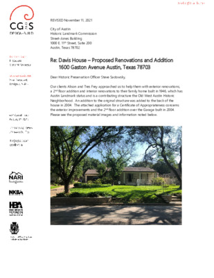
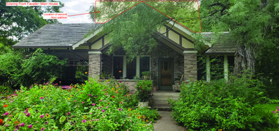
REVISED November 11, 2021 City of Austin Historic Landmark Commission Street-Jones Building 1000 E. 11th Street, Suite 200 Austin, Texas 78702 Re: Davis House – Proposed Renovations and Addition 1600 Gaston Avenue Austin, Texas 78703 Dear Historic Preservation Officer Steve Sadowsky, Our clients Alison and Tres Frey approached us to help them with exterior renovations, a 2nd floor addition and interior renovations to their family home built in 1946, which has Austin Landmark status and is a contributing structure the Old West Austin Historic Neighborhood. An addition to the original structure was added to the back of the house in 2004. The attached application for a Certificate of Appropriateness concerns the exterior improvements and the 2nd floor addition over the Garage built in 2004. Please see the proposed material images and information noted below. Proposed exterior renovations include the following: 2) Remove existing shutters at the front porch windows. 3) Replace the existing front door and sidelites with stained wood 1/2-lite double doors within existing masonry opening. The purpose is to bring more light into the dark entry. New doors will have clear beveled insulated glass, Rocky Mountain bronze hardware, and painted wood frame and stained wood doors similar to existing. 4) Add 19” tall gas copper lanterns beside front doors and electric copper lanterns on the site walls at the front of the sidewalk. 5) Replace five existing windows at the Living Room, Bedroom 3 and Bathroom 3 with insulated glass primed wood windows of the same size and function painted to match existing color. Manufacturer is Windsor Pinnacle or similar. Homeowner will submit for review and approval by the Historic Landmark Office the proposed window details in comparison with the existing windows to ensure that the sash and mullion sizes are similar. 6) Replace existing kitchen window with larger insulated glass primed wood window with mullions painted to match existing color. New window will be the same width with a lower sill and a higher head. Second floor 603.36 s.f. addition of Gameroom, Bedroom and Bathroom over the existing Garage and Laundry will include the following: 1) Smaller 12' wide wood overhead garage door similar to existing in design and finish. Cantilevered wood trellis over the garage door and window. 2) New 2'x2' insulated glass primed wood window in the Mudroom to painted to match color of existing windows. Similar to this existing window. 3) Reduce depth of …
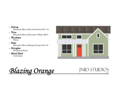
Benjamin Moore Sherwood Green HC-118 Benjamin Moore Decorator’s White PM-3 Benjamin Moore Blazing Orange 2011-20 o Siding o Trim o Windows White o Door o Shingles Weathered Wood o Metal Roof Galvalume Blazing Orange Green Siding Orange Door Precedent Blue Door White Trim
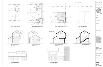
Existing Front Facade– Main HouseLocation of secondfloor addition Existing Rear Facade– Main HouseLocation of secondfloor additionLocation of firstfloor addition Location of secondfloor additionExisting Side Elevation– Main House Existing Side Elevation– Main HouseLocation of secondfloor addition Existing Front Facade Elevation– ADULocation of first &second flooraddition Existing Rear Facade Elevation– ADULocation of second flooraddition Location of first &second flooradditionExisting Side Elevation– ADU Location of secondfloor additionExisting Side Elevation– ADU 3 8 1 0 D U V A L 3 8 1 0 D U V A L MAIN HOUSE: FIRST FLOOR SCREEN PORCH ADDITION + SECOND FLOOR ADDTION & REMODEL GUEST HOUSE: FIRST FLOOR ADDITION + SECOND FLOOR ADDTION spot 614.2' 1 Isometric View Scale: 1/8" = 1'-0" McMANSION AREA CALCS : SF-3-NP LOT AREA BUILDABLE AREA (less setbacks) Max Impervious Coverage (45%) F.A.R. & Max Building Coverage (40%) = Total 12245 8256 5510 4898 x e = = = R 25'-0" 100% CRZ = e = R 20'-11 7/8" 50% CRZ #202 = e A/C R 10'-6" 25% CRZ = R 42'-0" 100% CRZ EXISTING GREEN HOUSE TO BE REMOVED EXISTING SHED TO REMAIN e = " 0 - ' 0 1 K C A B T E S D R A Y R A E R e = = X x = p o w e r p o l e INDEX OF SHEETS: (*) INCLUDED IN PERMIT FILING SET A 0 . 1 C O V E R | A R C H I T E C T U R A L S I T E P L A N A 1 . 0 D E M O L I T I O N P L A N S – M A I N H O U S E A 1 . 1 P R O P O S E D M A I N H O U S E F L O O R P L A N S A 2 . 0 E X T E R I O R E L E VAT I O N S A 3 . 0 A D U D E TA I L S REMOVE 88 SQFT OF IMP. COVER " 4 / 3 7 - ' 1 e = = REMOVE " 0 - ' 0 4 3 # N O T R O P I spot 614.6' NEW ELEC. METER LOCATION = = = CONSTRUCTION TO MEET 2015 …
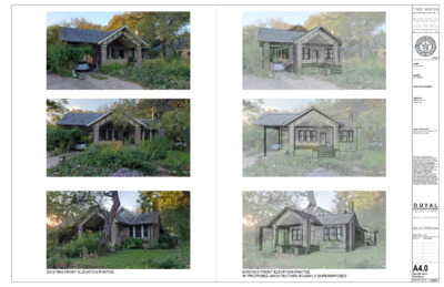
mad works mad works a r c h i t e c t u r e + M i c h a e l D i a n i , R A i n f o @ m a d - w o r k s . c o m 5 1 2 . 8 2 9 . 7 2 9 5 P . O . B o x 4 8 8 7 A u s t i n , T X 7 8 7 6 5 w w w . m a d - w o r k s . c o m N Y | N J | T X 11/28/21 CLIENT: Paul Carapetyan BUILDER: Paul Carapetyan STRUCTURAL ENGINEER: SURVEYOR: Waterloo Surveyors Thomas Dixon LEGAL DESCRIPTION: N63.36FT OF LOT 59 * & S16.64FT OF LOT 60 SHADOW LAWN Drawings and specifications as instruments of professional service are and shall remain the property of mad works. No reproduction or use, in whole or in part, shall be made without the written authorization of mad works. This document is intended solely for the construction of the project named herein and shall not be used by any other parties for any construction without the written consent of mad works. mad works waives any and all responsibility and liability for problems which arise from failure to follow these plans, specifications and design intent they convey, or for problems which arise from other's failure to obtain and/or follow mad works's guidance with respect to any errors, omissions, inconsistencies, ambiguities or conflicts which are alleged. D U V A L 3 8 1 0 D U V A L S T R E E T, A U S T I N , T X 7 8 7 5 1 I S S U E D F O R R E V I E W PRINT 11X17 DRAWINGS AT 50%. MEASURES AT 1/2 SCALE SHOWN ISSUE DATE SET 8/26/2021 CoA Issue #1 A4.0 R o u g h A rc h O v e rla y s P R I N T E D 11/28/21 EXISTING FRONT ELEVATION PHOTOS EXISTING FRONT ELEVATION PHOTOS W/ PROPOSED ARCHITECTURE ROUGHLY SUPERIMPOSED
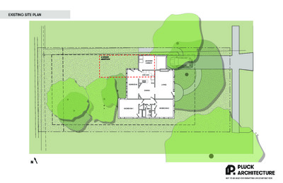
EXISTING SITE PLAN 2-STORY ADDITION LAUNDRY/ GARAGE KITCHEN DINING SUNROOM LIVING BEDROOM 1 BATH BEDROOM 2 N NOT TO BE USED FOR PERMITTING OR CONSTRUCTION PROPOSED SITE PLAN PDR. LAUNDRY DEN DINING KITCHEN LIVING SCREENED PORCH PATIO BEDROOM 3 W/D HALL BATH BEDROOM 2 N NOT TO BE USED FOR PERMITTING OR CONSTRUCTION EAST (STREET) RENDERING NOT TO BE USED FOR PERMITTING OR CONSTRUCTION NORTHEAST RENDERING NOT TO BE USED FOR PERMITTING OR CONSTRUCTION WEST (REAR) RENDERING NOT TO BE USED FOR PERMITTING OR CONSTRUCTION EAST (STREET) TWO-STORY ADDITION 15 FT FROM FRONT OF HOUSE NOT TO BE USED FOR PERMITTING OR CONSTRUCTION NORTHEAST NEW GABLE ROOF ON GARAGE/MUDROOM NOT TO BE USED FOR PERMITTING OR CONSTRUCTION NORTH MUDROOM DOOR ADDED HERE NOT TO BE USED FOR PERMITTING OR CONSTRUCTION WEST (REAR) NEW DOOR & WINDOW CONFIGURATION IN SUNROOM NOT TO BE USED FOR PERMITTING OR CONSTRUCTION SOUTH NO CHANGES TO THIS SIDE OF HOUSE NOT TO BE USED FOR PERMITTING OR CONSTRUCTION WOOG + PINKARD RESIDENCE REMODEL & ADDITION PROPERTY INFO LEGAL DESCRIPTION: N48.4 FT LOT 8 & S 11.6FT LOT 9 SHADOW LAWN ZONING: SF-3-HD-NCCD-NP AREA CALCS LOT SIZE: 8,196 SF GENERAL NOTES SHEET INDEX TREE NOTES: IMPERVIOUS COVERAGE: 2,876 SF (35%, MAX 45%) BUILDING COVERAGE: 1,900 SF (23%, MAX 40%) FAR: 2,185 SF (27%, MAX 40%) EXISTING RESIDENCE CONDITIONED: 1,490 SF RESIDENCE ADDITION, CONDITIONED: 695 SF TOTAL CONDITIONED: 2,185 SF SCREENED PORCH ADDITION: 300 SF REFER TO A2.0 ARCHITECTURAL A1.0 SITE PLAN A2.0 DEMO PLAN & GENERAL NOTES A2.1 FLOOR PLAN A2.2 ROOF PLAN A3.0 EXTERIOR ELEVATIONS A3.1 EXTERIOR ELEVATIONS A3.2 EXTERIOR ELEVATIONS 1. 2. 3. 4. AVOID 1/2 CRITICAL ROOT ZONE (CRZ) OF PROTECTED TREES WITH ANY NEW TRENCHING DONE ON SITE. IF CRZ CANNOT BE AVOIDED, TRENCHES WILL HAVE TO BE AIR SPADED BY A CERTIFIED ARBORIST FOR THE TOP 30" TO AVOID CUTTING ROOTS 1.5"+ IN DIAMETER. TREE PROTECTION FENCING IS REQUIRED FOR ALL TREES WITHIN THE LIMITS OF CONSTRUCTION. FENCING IS REQUIRED TO BE CHAIN-LINK MESH AT A MINIMUM HEIGHT OF 5'-0". WHEN TREE PROTECTION FENCING CANNOT INCORPORATE THE ENTIRE CRZ, AN 8" LAYER OF MULCH WITHIN THE ENTIRE AVAILABLE ROOT ZONE IS REQUIRED FOR ALL TREES WHICH HAVE ANY DISTURBANCE INDICATED WITHIN ANY PORTION OF THE CRZ. FOOT TRAFFIC IS CONSIDERED A DISTURBANCE OF THE CRZ. 2x4 OR GREATER SIZED PLANKS (6'-0" TALL MINIMUM) ARE REQUIRED TO BE STRAPPED SECURELY AROUND PROTECTED …
From: To: Cc: Subject: Date: Attachments: Hall, Stephanie Boards and Commissions Rodriguez, Joseph 2022 Regular Meeting Schedule Wednesday, October 6, 2021 6:03:17 PM Reservation Form.docx Dear Liaisons, That time of year has come upon us once again - it’s time to approve annual schedules! Although there is still some uncertainty in how meetings will look next year, each board or commission should approve their regular meeting schedule as they “normally” would. Please make sure your board or commission approves their 2022 regular meeting schedule in October or early November. Once approved, please send the approved schedule over to me (and Cc: Joseph) to review. We must receive the approved schedule by November 30th to maintain the Board’s place in the scheduling queue. The schedules should be approved as if meetings will be occurring in person. Adjustments will be made should anything change. Is your Board or Commission wanting to change the regular date/time of their meetings? Keep in mind any potential changes may cause rippling scheduling conflicts. Most boards and commissions have established dates and times to maintain a decent rotation and room availability. We will likely not be able to accommodate any changes in the schedule for City Hall rooms. Additionally, we are currently ONLY able to utilize Chambers or the Boards and Commissions Room for meetings at City Hall due to occupancy limits in place to accommodate social distancing. There is no telling when or how that will change, so I’m including a list of alternate contacts for other meeting locations below. Does your Board/Commission normally meet in City Hall? In addition to the approved schedule, complete and send the attached room request form. Typically reservation requests for City Hall should be sent to the reservation desk, but please send the annual requests to Joseph or I so they can be reviewed first. Other things to keep in mind: Please have the schedule discussion and approval on your B/C agenda as soon as possible. Schedules must be APPROVED by the Board or Commission to be added to the scheduling queue. Do not send us any draft calendars. We will not begin booking rooms until Council and Council Committees have approved their schedules and booked the necessary rooms. City Hall is at capacity – priority is given to meetings that have historically met in a specific room during a specific date/time. However your approved schedules must be submitted on …
Dear Commissioners, I am reaching out to you regarding Item A.1, which is the City Staff’s proposal to move future Board of Adjustment, Planning Commission and Zoning and Platting Commission Meetings to a new location in far North Austin. In regards to this item, please know that I am not speaking on the behalf of the Southeast Combined Neighborhood Plan Contact Team, but this item is on our next meeting's agenda, which is scheduled for December 13, 2021. It is listed on the SCNPCT Agenda as a "Discussion and Possible Action" item. The SCNPCT membership was alerted on this issue during our last meeting, but it was too late for us to formally consider and respond (vote) to any concerns we may have. I must say that we were extremely surprised to know this was even being considered. Our Contact Team represents residents from the City of Austin and Del Valle. As a D2 resident, I would fully support any efforts to ensure the Board of Adjustment, Planning Commission and Zoning and Platting Commission meetings stay centrally located at City Hall. Moving the meetings would add an undue burden to the residents in far SE Austin and Travis County. As you are aware, our population is very diverse and mostly representative of low-income and people of color, plus there would be challenges in having access to public transportation in order to make meetings on time or even return home safely, if there is any public transportation available when the meetings run extremely late. I do not think the Equity Office was consulted on the impact this move would have for vulnerable populations? The City Hall location is central and the logically best location for all residents when it comes to equal access for all residents. Additionally, because City Hall is centrally located, the surrounding residents and businesses would be best equally served, including equally disadvantaged. If the meetings are moved far North, those living and/or working in South Austin, particularly SE Austin, will be at a much greater disadvantage to publicly engage in BOA, PC and ZAP hearings. This could have an adverse impact on our community when equal access to community engagement is not afforded to the residents of the City of Austin and Travis County. With all the growth in our area, specifically in Southeast Austin, it will make it harder if not impossible for our community to …
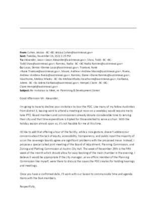
From: Cohen, Jessica - BC <BC-Jessica.Cohen@austintexas.gov> Sent: Tuesday, November 16, 2021 1:25 PM To: Alexander, Jason <Jason.Alexander@austintexas.gov>; Shaw, Todd - BC <BC- Todd.Shaw@austintexas.gov>; Ramirez, Nadia - BC <BC-Nadia.Ramirez@austintexas.gov> Cc: Lucas, Denise <Denise.Lucas@austintexas.gov>; Truelove, Rosie <Rosie.Truelove@austintexas.gov>; Moore, Andrew <Andrew.Moore@austintexas.gov>; Rivera, Andrew <Andrew.Rivera@austintexas.gov>; Ramirez, Elaine <Elaine.Ramirez@austintexas.gov>; Hawthorne, Melissa Whaley - BC <bc-MelissaWhaley.Hawthorne@austintexas.gov>; Kiolbassa, Jolene - BC <bc-Jolene.Kiolbassa@austintexas.gov>; Hempel, Claire - BC <BC- Claire.Hempel@austintexas.gov> Subject: Re: Invitation to Meet, re: Permitting & Development Center Good Afternoon Mr. Alexander, I'm going to have to decline your invitation to tour the PDC. Like many of my fellow Austinites from district 3, leaving work to attend a meeting at noon on a weekday would require me to take PTO. Board members and commissioners already donate considerable time to serving their city and that time expenditure is tripled for those elected to serve as chair. With the holiday season almost upon us, it's not feasible for me at this time. I'd like to add that offering a tour of the facility, while a nice gesture, doesn't address our concerns about the lack of equity, accessibility, transparency, and public input the majority of us on the sovereign boards agree are significant problems with the proposed move. Instead, I propose a special called joint meeting of the Board of Adjustment, Planning Commission, and Zoning and Platting Commission at Austin City Hall. The week of November 29th is the fifth week of the month which should allow for easy booking of the main chamber in the evening. I believe it would be appropriate if the city manager, an ex-officio member of the Planning Commission like myself, were there to discuss the issues the PDC creates for holding hearings and meetings. Once you have a confirmed date, I'll work with our liaison to communicate time and agenda items with the BoA members. Respectfully, ---------- Jessica Cohen Chair Board of Adjustment From: Alexander, Jason <Jason.Alexander@austintexas.gov> Sent: Friday, November 12, 2021 3:08 PM To: Kiolbassa, Jolene - BC <bc-Jolene.Kiolbassa@austintexas.gov>; Shaw, Todd - BC <BC- Todd.Shaw@austintexas.gov>; Cohen, Jessica - BC <BC-Jessica.Cohen@austintexas.gov> Cc: Lucas, Denise <Denise.Lucas@austintexas.gov>; Truelove, Rosie <Rosie.Truelove@austintexas.gov>; Moore, Andrew <Andrew.Moore@austintexas.gov>; Rivera, Andrew <Andrew.Rivera@austintexas.gov> Subject: Invitation to Meet, re: Permitting & Development Center Chairs Kiolbassa, Shaw, and Cohen Good afternoon. I hope this email finds all of you well. My name is Jason Alexander – I am the Assistant to the City Manager, and I wanted to take this opportunity to reach out on …
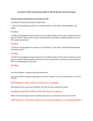
November 29, 2021 Joint Meeting of BOA, PC and ZAP Question and Answer Report Item A1 Land Use Commissions Use of Austin City Hall Commissioner Richard Smith, Board of Adjustment: 1. Why did City management decide to move BOA meetings to PDC without informing BOA or the public? 2. When City management made its decision to move BOA meetings to PDC, what considerations were given to the PDC's lack of central location, and the burden on the public and BOA members to come to PDC rather than City Hall? 3. What are City management's responses to the "Whereas" points made in the BOA resolution dated November 8, 2021? 4. When City management made its decision to move BOA meetings to PDC, what considerations were given to possible public perceptions of the move, such as the perceived importance (or lack thereof) of BOA to City development and growth. Pending Pending Pending Pending Vice-Chair Kiolbassa, Zoning and Planning Commission: Why was the ICRC certification meeting held at the PDC instead of in City Council Chambers, like it was in 2013? Staff Response: Room within City Hall were unavailable. What groups will be using council chambers when the land use commissions vacate? Pending; forwarded to Office of the City Clerk for response. Where in the Zucker Report does it recommend that land use commissions move from City Hall? Staff Response: The Zucker report has no recommendations on meeting locations.
Zucker Report Full Report www.austintexas.gov/sites/default/files/files/Development_Services/ZuckerFinalReport/ZuckerFinalRep ort.pdf XVI. Boards and Commissions http://www.austintexas.gov/sites/default/files/files/Development_Services/ZuckerFinalReport/Zuck erFinalReport_16_BoardsCommissions.pdf