REGULAR MEETING OF THE URBAN TRANSPORTATION COMMISSION TUESDAY, JULY 7, 2026, AT 5:00 P.M. CITY HALL, ROOM 1101 301 WEST SECOND STREET AUSTIN, TEXAS Some members of the Urban Transportation Commission may be participating by videoconference. The meeting may be viewed online at: http://www.austintexas.gov/page/watch-atxn-live. Public comment will be allowed in-person or remotely via telephone. Speakers may only register to speak on an item once, either in person or remotely, and will be allowed up to three minutes to provide their comments. Registration no later than noon the day before the meeting is required for remote participation by telephone. To register to speak remotely, contact Natalie Leone, 512-974- 3428, natalie.leone@austintexas.gov. CURRENT COMMISSIONERS: Susan Somers, Chair Daniel Kavelman, Parliamentarian Deshon Brown Heather Buffo Kevin Chen Nathan Fernandes Justin Jacobson Varun Prasad Spencer Schumacher, Vice Chair AGENDA CALL TO ORDER PUBLIC COMMUNICATION: GENERAL The first 5 speakers signed up prior to the meeting being called to order will each be allowed a three- minute allotment to address their concerns regarding items not posted on the agenda. APPROVAL OF MINUTES 1. Approve the minutes of the Urban Transportation Commission Regular meeting on 6/2/2026. DISCUSSION ITEMS 2. Special Events Overview. Presentation by Maria Alonso, Program Manager, Austin Center for Events and Annette Martinez, Division Manager, Austin Transportation and Public Works. DISCUSSION AND ACTION ITEMS 3. Approve the Right of Way Vacation for 2026-071422 LM – 305 Edwin Lane. Presentation by Christopher Bueckert, Real Estate Services Agent, Austin Transportation and Public Works. 4. Approve the Right of Way Vacation for 2026-071407 LM – 8700 Hergotz Lane. Presentation by Christopher Bueckert, Real Estate Services Agent, Austin Transportation and Public Works. 5. Establish a Working Group for a recommendation regarding amendments to the Austin Strategic Mobility Plan. 6. Discussion and adoption of the Urban Transportation Commission Annual Report. COMMITTEE UPDATES 7. Update from Commissioner Chen from the Downtown Commission regarding actions taken at the June 17, 2026, meeting. 8. Update from Commissioner Prasad from the Joint Sustainability Committee regarding actions taken at the June 24, 2026, meeting. 9. Update from Commissioner Kavelman from the Pedestrian Advisory Council regarding actions taken at the July 6, 2026, meeting. 10. Update from Chair Somers from the Community Advisory Committee of the Austin Transit Partnership Board regarding actions taken at the June 11, 2026, meeting. FUTURE AGENDA ITEMS ADJOURNMENT The City of Austin is committed to compliance with the Americans with Disabilities …
URBAN TRANSPORTATION COMMISSION MEETING MINUTES URBAN TRANSPORTATION COMMISSION REGULAR MEETING MINUTES Tuesday, June 2, 2026 The Urban Transportation Commission convened in a regular meeting on Tuesday, June 2, 2026, at Austin City Hall, Boards and Commissions Room 1101, Austin, Texas. Chair Somers called the Commission Meeting to order at 5:03 p.m. Commissioners in Attendance: Susan Somers - (District 4) Spencer Schumacher, Vice Chair - (District 9) Daniel Kavelman - (District 5) Nathan Fernandes (District 2) Commissioners in Attendance Virtually: Heather Buffo - (District 1) Kevin Chen - (District 6) Varun Prasad (District 7) Deshon Brown (Mayoral) PUBLIC COMMUNICATION Elizabeth Levin Garrett Tung APPROVAL OF MINUTES 1. Approve the minutes of the URBAN TRANSPORTATION COMMISSION REGULAR MEETING on 5/5/2026. The minutes of the 5/5/2026 meeting were approved on a motion from Commissioner Kavelman, seconded by Commissioner Fernandes, on a 7-0 vote, with Commissioner Chen off the dais and Commissioner Jacobson absent. DISCUSSION ITEMS 2. Curb Management Plan Update. The commission received a presentation from Joseph Al-Hajeri, Parking Enterprise Manager, and Lewis Leff, Assistant Director, Austin Transportation and Public Works. 3. Parking Transportation Management Districts Overview. The commission received a presentation from Joseph Al-Hajeri, Parking Enterprise Manager, and Lewis Leff, Assistant Director, Austin Transportation and Public Works. 1 URBAN TRANSPORTATION COMMISSION MEETING MINUTES DISCUSSION AND ACTION ITEMS 4. Approve a recommendation regarding funding transit enhancements through the proposed Dog’s Head Tax Increment Reinvestment Zone. Comment Received: Zenobia Joseph, Katie Kam On a motion from Commissioner Schumacher, and a second from Commissioner Kavelman approved with an 8-0 vote, with Commissioner Jacobson absent. COMMITTEE UPDATES 5. Update from Commissioner Chen from the Downtown Commission regarding actions taken at the May 20, 2026, meeting. The commission received an update from Commissioner Chen. 6. Update from Commissioner Prasad from the Joint Sustainability Committee regarding actions taken at the May 13, 2026, meeting. The Commission received an update from Commissioner Prasad. 7. Update from Commissioner Schumacher from the Bicycle Advisory Council regarding actions taken at the May 19, 2026, meeting. The commission received an update from Commissioner Schumacher. 8. Update from Commissioner Kavelman from the Pedestrian Advisory Council regarding actions taken at the June 1, 2026, meeting. The commission received an update from Commissioner Kavelman. 9. Update from Chair Somers from the City Council Mobility Committee regarding actions taken at the May 14, 2026, meetings. The commission received an update from Commissioner Somers. 10. Update from Chair …
REGULAR MEETING OF THE URBAN TRANSPORTATION COMMISSION TUESDAY, JUNE 2, 2026, AT 5:00 P.M. CITY HALL, ROOM 1101 301 WEST SECOND STREET AUSTIN, TEXAS Some members of the Urban Transportation Commission may be participating by videoconference. The meeting may be viewed online at: http://www.austintexas.gov/page/watch-atxn-live Public comment will be allowed in-person or remotely via telephone. Speakers may only register to speak on an item once, either in person or remotely, and will be allowed up to three minutes to provide their comments. Registration no later than noon the day before the meeting is required for remote participation by telephone. To register to speak remotely, contact Natalie Leone, 512-974- 3428, natalie.leone@austintexas.gov. CURRENT COMMISSIONERS: Susan Somers, Chair Daniel Kavelman, Parliamentarian Deshon Brown Heather Buffo Kevin Chen Nathan Fernandes Justin Jacobson Varun Prasad Spencer Schumacher, Vice Chair AGENDA CALL TO ORDER PUBLIC COMMUNICATION: GENERAL The first 5 speakers signed up prior to the meeting being called to order will each be allowed a three- minute allotment to address their concerns regarding items not posted on the agenda. APPROVAL OF MINUTES 1. Approve the minutes of the Urban Transportation Commission Special Called meeting on 5/5/2026. DISCUSSION ITEMS 2. 3. Curb Management Plan Update. Presentation by Joseph Al-Hajeri, Parking Enterprise Manager, Austin Transportation and Public Works. Parking Transportation Management Districts Overview. Presentation by Joseph Al-Hajeri, Parking Enterprise Manager, Austin Transportation and Public Works. DISCUSSION AND ACTION ITEMS 4. Approve a recommendation regarding funding transit enhancements through the proposed Dog’s Head Tax Increment Reinvestment Zone COMMITTEE UPDATES 4. 5. 6. 7. 8. 9. Update from Commissioner Chen from the Downtown Commission regarding actions taken at the May 20, 2026, meeting. Update from Commissioner Prasad from the Joint Sustainability Committee regarding actions taken at the May 13, 2026, meeting. Update from Commissioner Schumacher from the Bicycle Advisory Council regarding actions taken at the May 19, 2026, meeting. Update from Commissioner Kavelman from the Pedestrian Advisory Council regarding actions taken at the June 1, 2026, meeting. Update from Chair Somers from the City Council Mobility Committee regarding actions taken at the May 14, 2026, meeting. Update from Chair Somers from the Community Advisory Committee of the Austin Transit Partnership Board regarding actions taken at the May 14, 2026, meeting. FUTURE AGENDA ITEMS ADJOURNMENT The City of Austin is committed to compliance with the Americans with Disabilities Act. Reasonable modifications and equal access to communications will be provided upon request. …
URBAN TRANSPORTATION COMMISSION MEETING MINUTES URBAN TRANSPORTATION COMMISSION REGULAR MEETING MINUTES Tuesday, May 5, 2026 The Urban Transportation Commission convened in a regular meeting on Tuesday, April 7, 2026, at Austin City Hall, Boards and Commissions Room 1101, Austin, Texas. Chair Somers called the Commission Meeting to order at 5:09 p.m. Commissioners in Attendance: Susan Somers - (District 4) Spencer Schumacher, Vice Chair - (District 9) Daniel Kavelman - (District 5) Commissioners in Attendance Virtually: Heather Buffo - (District 1) Kevin Chen - (District 6 Deshon Brown (Mayoral) PUBLIC COMMUNICATION APPROVAL OF MINUTES 1. Approve the minutes of the URBAN TRANSPORTATION COMMISSION REGULAR MEETING on 4/7/2026. The minutes of the 4/7/2026 meeting were approved on a motion from Commissioner Schumacher, seconded by Commissioner Somers, on a 6-0 vote, with Commissioners Fernandes, Prasad, Jacobson and Sorin absent. DISCUSSION ITEMS 2. Bond Funded Bridge Projects Update. The commission received presentations from Eric Bailey, Deputy Director and Genest Landry, Assistant Director, Austin Capitol Delivery Services. 3. Climate Pollution Reduction Grant Update. The commission received a presentation from Jacob Barrett, Program Manager and Shannon Riley, Program Manager, Austin Transportation and Public Works. COMMITTEE UPDATES 8. Update from Commissioner Chen from the Downtown Commission regarding actions taken at the April 15, 2026, meeting. The commission received an update from Commissioner Chen. 1 URBAN TRANSPORTATION COMMISSION MEETING MINUTES 9. Update from Commissioner Schumacher from the Bicycle Advisory Council regarding actions taken at the April 21, 2026, meeting. The commission received an update from Commissioner Schumacher. 10. Update from Commissioner Kavelman from the Pedestrian Advisory Council regarding actions taken at the May 4, 2026, meeting. The commission received an update from Commissioner Kavelman. 11. Update from Chair Somers from the City Council Mobility Committee regarding actions taken at the April 29, 2026, meetings. The commission received an update from Commissioner Somers. 12. Update from Chair Somers from the Community Advisory Committee for the Austin Transit Partnership Board regarding actions taken at the April 9, 2026, meeting. The commission received an update from Commissioner Somers. FUTURE AGENDA ITEMS New Future Agenda Items Discussed: • APD traffic safety • ETOD cycle ADJOURNMENT Chair Somers adjourned the meeting at 7:09 p.m. without objection. The minutes were approved at the June 2, 2026, meeting on a motion from Commissioner XX, seconded by Commissioner XX, with a X-X vote. 2
BOARD/COMMISSION RECOMMENDATION Urban Transportation Commission Recommendation 20260602-004: Dog’s Head Transit Enhancements WHEREAS, the development agreement contemplates building an advanced manufacturing center, an extension of the Colorado River Trail, parkland, and multi-family housing, including affordable housing, as part of the future Dog’s Head development; WHEREAS, on July 23rd, 2026, the City Council will consider a Tax Increment Reinvestment Zone (TIRZ) for the Dog’s Head to provide a financing mechanism for the construction of public infrastructure necessary to provide adequate service to the Dog’s Head; WHEREAS, on May 21st, 2026, the Austin City Council authorized a development agreement and annexation for approximately 2,614 acres located in the City’s extraterritorial jurisdiction bounded by the Colorado River, US Highway 183, and State Highway 130, in the area generally known as the “Dog's Head”; DRAFT NOW, THEREFORE, BE IT RESOLVED, that the Urban Transportation Commission (UTC) recommends that city staff work with the Austin Transit Partnership and CapMetro to evaluate opportunities to fund transit enhancements through the Dog’s Head TIRZ, including evaluating the feasibility of the following: WHEREAS, at 2,614 acres, the Dog’s Head development is 367% larger than Mueller (711 acres), which was also built primarily using a TIRZ; WHEREAS, portions of the Dog’s Head development will be located within 1 mile of the future Yellow Jacket light rail station and the future Green Line Commuter Rail Station at 183; ● An extension of the Project Connect Light Rail with a stop in the Dog’s Head TIRZ as part ● A MetroRapid or high-frequency CapMetro bus route connecting the Dog’s Head to the of the future Airport Extension; and CapMetro Green Line and the Airport. BE IT FURTHER RESOLVED, that the UTC recommends that City Staff report these options to the City Council prior to the July 23rd, 2026 City Council Meeting. Motioned by: Seconded by: Date of Approval: Record of the vote: Attest: _____________________________________________ (Staff or board member can sign) DRAFT
BOARD/COMMISSION RECOMMENDATION Urban Transportation Commission Recommendation 20260602-004: Dog’s Head Transit Enhancements WHEREAS, on May 21st, 2026, the Austin City Council authorized a development agreement and annexation for approximately 2,614 acres located in the City’s extraterritorial jurisdiction bounded by the Colorado River, US Highway 183, and State Highway 130, in the area generally known as the “Dog's Head”; WHEREAS, on July 23rd, 2026, the City Council will consider a Tax Increment Reinvestment Zone (TIRZ) for the Dog’s Head to provide a financing mechanism for the construction of public infrastructure necessary to provide adequate service to the Dog’s Head; WHEREAS, the development agreement contemplates building an advanced manufacturing center, an extension of the Colorado River Trail, parkland, and multi-family housing, including affordable housing, as part of the future Dog’s Head development; WHEREAS, portions of the Dog’s Head development will be located within 1 mile of the future Yellow Jacket light rail station and the future Green Line Commuter Rail Station at 183; WHEREAS, at 2,614 acres, the Dog’s Head development is 367% larger than Mueller (711 acres), where the public infrastructure was also built primarily using a TIRZ; NOW, THEREFORE, BE IT RESOLVED, that the Urban Transportation Commission (UTC) recommends that city staff work with the Austin Transit Partnership and CapMetro to evaluate opportunities to fund transit enhancements through the Dog’s Head TIRZ, including evaluating the feasibility of the following: ● An extension of the Project Connect Light Rail with a stop in the Dog’s Head TIRZ as part of the future Airport Extension; and ● A MetroRapid or high-frequency CapMetro bus route connecting the Dog’s Head to the CapMetro Green Line and the Airport. BE IT FURTHER RESOLVED, that the UTC recommends that City Staff report these options to the City Council prior to the July 23rd, 2026 City Council Meeting. Motioned by: Commissioner Schumacher Seconded by: Commissioner Somers Date of Approval: 6/2/2026 Record of the vote: 8-0 Attest: _____________________________________________ (Staff or board member can sign)
Parking District Program Staff Update Austin Transportation Public Works Department | Urban Transportation Commission June 2, 2026 Presenters: Lewis Leff, Assistant Director & Joseph Al-hajeri, Parking Enterprise Division Manager Agenda Program History Parking Benefit District (PBD) Parking and Transportation Management District (PTMD) Parking District Requirements & Coordination Current Parking District Areas Overview Closer Look at Each Parking District Next Steps 2 Program History Austin established it's first parking benefit district (PBD) in West Campus as a pilot program, funded by a federal grant (RESOLUTION NO. 20050728-013). West Campus PBD boundary was expanded and approved by Council. 2011 2014 2006 2013 PBD ordinance §12-6 was adopted by Council with West Campus being the first district. A new parking district designation was adopted by Council called a parking and transportation management district (PTMD). §12-7 3 §12-7 Parking & Transportation Management Districts Purpose The goal of this program is to help improve traffic flow, curbside management, and mobility within designated areas of the city through coordinated community engagement, curbside management strategies and transportation improvements. Community Benefit • Community representation on district stakeholder group • 51 percent of the public paid parking revenue, less City expenses, dedicated for mobility infrastructure projects. • Projects could include: Eligibility Requirements to Form A New District • An area with at least 100 on-street paid parking spaces or at least 200 off-street paid parking spaces • Initial discovery meeting with TPW • Fill in sidewalk gaps • Sidewalk rehabilitation • Pedestrian crossing islands • Street trees • Once initial plan is created, present in community for • Mobility studies (that lead to projects) feedback • Approval of an ordinance establishing the district by City Council 4 District Coordination Process Current Process Aiming to meet quarterly to provide updates financials and parking related issues Projects proposed by PTMD Advisory Board Members, TPW staff, and community members. Potential projects analyzed by TPW staff Approval sheet signed by PTMD Advisory Board, Transportation Engineer, Parking Enterprise Division Manager, TPW Department Director Challenges Consistent representation on community stakeholder groups, holding regular formal meetings. Establishing consistent process for project selection now that funds are accumulating. 5 Map of Active Districts Parking District Areas District Names West Campus (PBD): Est. 2011/13 East Austin: Est. 2015 Mueller: Est. 2015 Colorado River: Est. 2018 South Congress: Est. 2023 6 …
CapMetro Green Line Austin Light Rail Phase I Austin Light Rail Phase I Priority Extension FOR DISCUSSION PURPOSES ONLY***THIS DOCUMENT HAS NOT BEEN REVIEWED BY THE CITY OF AUSTIN, AUSTIN TRANSIT PARTNERSHIP, ORCAPMETRO*** CapMetro Green Line Austin Light Rail Phase I Austin Light Rail Phase I Priority Extension Possible Dog’s Head Metro Rapid FOR DISCUSSION PURPOSES ONLY***THIS DOCUMENT HAS NOT BEEN REVIEWED BY THE CITY OF AUSTIN, AUSTIN TRANSIT PARTNERSHIP, ORCAPMETRO*** CapMetro Green Line Austin Light Rail Phase I Possible Dog’s Head Light Rail Alignment FOR DISCUSSION PURPOSES ONLY***THIS DOCUMENT HAS NOT BEEN REVIEWED BY THE CITY OF AUSTIN, AUSTIN TRANSIT PARTNERSHIP, ORCAPMETRO***
Curbside Management Plan Staff Update Austin Transportation Public Works Department | Urban Transportation Commission June 2, 2026 Presenters: Lewis Leff, Assistant Director & Joseph Al-hajeri, Parking Enterprise Division Manager Agenda • Background • Work Completed Since Last Update • Refined Draft Curb Typology Framework Overview • Draft Typology Assignment Process • • Examples of Typology Assignment Existing Conditions Analysis • Applying Curbside Management Strategies • Next Steps Background Timeline: • Council request to conduct a study in 2024 • Contract executed: May 2025 • Project kick-off: June 2025 • Draft Deliverable: May 2026 • Final Deliverable: Early July 2026 Example from City of Atlanta Curbside Management Plan Final deliverable: Curb Management Plan (CMP) that guides operational decision-making; not a regulatory document Work Completed Since Previous UTC Update • Refined Typology Framework • Reflects combined analysis of curb activity, land use, and mobility functions • Completed Existing Conditions Analysis • Data-supported identification of core issues to address • Typology Assignment Process and Application • Developed step-by-step process to assign curb types to street segments • Created initial map of the City’s street network • Management Strategies and Implementation • Established priority areas: pricing, loading, enforcement, and coordination • Concepts for framework application, pilots, and phased rollout Refined Typology Framework Primary drivers for defining types Curb Types Multiple Factors and Pressures. Curbs that have overlapping high pressures such as High Activity Mobility and Entertainment. Mobility-focused streets. Transit, vehicles, bikes, and pedestrian uses in the curbside lane without on-street parking. Adjacent supporting streets are important to manage, especially for high activity streets where little off-street parking exists. Supporting streets. Curbs that are impacted by high activity areas (Entertainment or Mobility) where spillover impacts need special considerations. Use or activity-driven types. The intensity of uses and different types of land uses are the defining factor of allocation and management. Multiple High Pressures High Activity Mobility Corridors Moderate Activity Mobility Corridors Supporting Streets Entertainment or Dining Business or Commercial Parks or Open Space Neighborhood Avenues Local Streets Refined Typology Framework Refined Typology Framework The typology framework can be applied citywide to consistently evaluate and assign curb types. Sample Area: N Lamar Blvd at W 15th Street Shades represent different land use Refined Typology Framework – Primary Movement N Lamar at 24th St Corridor serves high traffic volume Corridor serves high traffic volume Single adjacent use (parks) Curbside lane dedicated to movement Refined Typology Framework – …
REGULAR MEETING OF THE URBAN TRANSPORTATION COMMISSION TUESDAY, MAY 5, 2026, AT 5:00 P.M. CITY HALL, ROOM 1101 301 WEST SECOND STREET AUSTIN, TEXAS Some members of the Urban Transportation Commission may be participating by videoconference. The meeting may be viewed online at: http://www.austintexas.gov/page/watch-atxn-live Public comment will be allowed in-person or remotely via telephone. Speakers may only register to speak on an item once, either in person or remotely, and will be allowed up to three minutes to provide their comments. Registration no later than noon the day before the meeting is required for remote participation by telephone. To register to speak remotely, contact Natalie Leone, 512-974- 3428, natalie.leone@austintexas.gov. CURRENT COMMISSIONERS: Susan Somers, Chair Daniel Kavelman, Parliamentarian Deshon Brown Heather Buffo Kevin Chen Nathan Fernandes Justin Jacobson Varun Prasad Joshua Sorin Spencer Schumacher, Vice Chair AGENDA CALL TO ORDER PUBLIC COMMUNICATION: GENERAL The first 5 speakers signed up prior to the meeting being called to order will each be allowed a three- minute allotment to address their concerns regarding items not posted on the agenda. APPROVAL OF MINUTES 1. Approve the minutes of the Urban Transportation Commission Special Called meeting on 4/7/2026. DISCUSSION ITEMS 2. 3. Bond Funded Bridge Projects Update. Presentation by Eric Bailey, Deputy Director and Genest Landry, Assistant Director, Austin Capitol Delivery Services. Climate Pollution Reduction Grant Update. Presentation by Kristin Pipkin, Consulting Engineer, Austin Transportation and Public Works. COMMITTEE UPDATES 4. 5. 6. 7. 8. Update from Commissioner Chen from the Downtown Commission regarding actions taken at the April 15, 2026, meeting. Update from Commissioner Schumacher from the Bicycle Advisory Council regarding actions taken at the April 21, 2026, meeting. Update from Commissioner Kavelman from the Pedestrian Advisory Council regarding actions taken at the May 4, 2026, meeting. Update from Chair Somers from the City Council Mobility Committee regarding actions taken at the April 29, 2026, meeting. Update from Chair Somers from the Community Advisory Committee of the Austin Transit Partnership Board regarding actions taken at the April 9, 2026, meeting. FUTURE AGENDA ITEMS ADJOURNMENT The City of Austin is committed to compliance with the Americans with Disabilities Act. Reasonable modifications and equal access to communications will be provided upon request. For assistance, please contact the Liaison or TTY users’ route through 711. A person may request language access accommodation no later than 48 hours before the scheduled meeting. Please call or email Natalie Leone at …
URBAN TRANSPORTATION COMMISSION MEETING MINUTES URBAN TRANSPORTATION COMMISSION REGULAR MEETING MINUTES Tuesday, April 7, 2026 The Urban Transportation Commission convened in a regular meeting on Tuesday, April 7, 2026, at Austin City Hall, Boards and Commissions Room 1101, Austin, Texas. Chair Somers called the Commission Meeting to order at 5:06 p.m. Commissioners in Attendance: Susan Somers - (District 4) Nathan Fernandes – (District 2) Spencer Schumacher, Vice Chair - (District 9) Commissioners in Attendance Virtually: Heather Buffo - (District 1) Daniel Kavelman - (District 5) Varun Prasad, - (District 7) Justin Jacobson - (District 8) Deshon Brown (Mayoral) PUBLIC COMMUNICATION Scott Johnson APPROVAL OF MINUTES 1. Approve the minutes of the URBAN TRANSPORTATION COMMISSION SPECIAL CALLED MEETING on 3/16/2026. The minutes of the 3/16/2026 meeting were approved on a motion from Commissioner Schumacher, seconded by Commissioner Fernandes, on a 7-0 vote, with Commissioners Chen, Jacobson and Sorin absent. DISCUSSION ITEMS 2. Project Connect Update, including the Federal Transit Administration record of decision for Austin Light Rail Phase 1. The commission received presentations from Jennifer Pyne, EVP, Planning, Community & Federal Programs, and Lindsay Wood, EVP, Engineering & Construction, Austin Transit Partnership. 3. Austin Core Transportation Plan Update. Movability Commuter Survey update The commission received a presentation from Kathleen Lu, Movability. 4. Citywide Lighting Plan update. 1 URBAN TRANSPORTATION COMMISSION MEETING MINUTES The commission received a presentation from Joel Meyer, Transportation Officer, Austin Transportation and Public Works. DISCUSSION AND ACTION ITEMS 5. Approve the Right of Way Vacation for 2024-011813 LM - 1909 Comal Street The commission received a presentation from Christopher Bueckert, Real Estate Services Agent, Austin Transportation and Public Works. On a motion from Commissioner Kavelman, and a second from Commissioner Schumacher approved with an 8-0 vote, with Commissioners Chen and Sorin absent. 6. Approve a recommendation to Council regarding the 2026 Bond Program. On a motion from Commissioner Schumacher, and a second from Commissioner Fernandes approved with an 8-0 vote, with Commissioners Chen and Sorin absent. 7. Approve officer appointments to the Urban Transportation Commission. On a motion from Commissioner Schumacher, and a second from Commissioner Kavelman, the office of Chair was approved as amended with an 8-0 vote, with Commissioners Chen and Sorin absent. On a motion from Commissioner Somers, and a second from Commissioner Fernandes, the office of Vice Chair was approved as amended with an 8-0 vote, with Commissioners Chen and Sorin absent. On a …
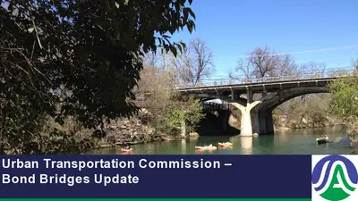
Urban Transportation Commission – Bond Bridges Update Agenda 1 Barton Springs Road Bridge 2 Redbud Trail Bridge 3 William Cannon Road Overpass 4 Wishbone Bridge 2 2 Barton Springs Road Bridge 100 years old built in 1926 1946 Bridge Expansion 20,000 Vehicles per day Key Entrance to Zilker Park and for Major City Events FUNDING SOURCE: • Preliminary Design: 2012, 2018 and 2020 Bonds • Design: 2020 Bond • Construction: FHWA/City 3 City Council Actions 1 Direction from Council in 2020 Bond Resolution (20200812-011): 2 Previous Council Action/Hearings: 11/30/23 – Council conducts a public hearing to recommend the bridge replacement alternative 12/12/23 – Council work session on the recommended option 12/14/23 – Council conducts a public hearing and directs Staff to pursue replacement option 03/07/24 – Council Directs TPW Director to apply for a federal bridge grant to replace the bridge 05/02/24 – Council approves additional engineering services for the bridge replacement 04/24/25 – Council approves accepting $32M in grant funds from the FHWA for bridge replacement 4 Project Development Process PRELIMINARY PHASE 2015 - 2023 DESIGN PHASE 2024 - 2027 CONSTRUCTION PHASE 2027 - 2029 PUBLIC MEETING April 2023 RESPOND TO COMMENTS Summer 2023 REFINE REPORT Fall 2023 COUNCIL ACTION December 2023 60% DESIGN + NEPA PUBLIC MEETINGS + BOARDS AND COMMISSIONS FINAL DESIGN AND PERMITTING BID AND AWARD + COUNCIL ACTION CONSTRUCTION WE ARE HERE Analysis Structural and Mobility Analysis: • • • • External Structure - Spalling Concrete • ADA compliance – Pedestrian Circulation Internal Structure – Deteriorating Steel Geotechnical Data –Replacement Design • Pedestrian and Bicycle Mobility – no improvement to existing condition Cost/Benefit Analysis – extended life vs. cost Historic Analysis: • Coordinated with US Army Corps (USACE) and Texas Historic Commission (THC) • The bridge is a contributing feature to the Zilker Park Historic Landmark designation • The Texas Historic Commission has approved potentially fully replacing the bridge. As the process continues, the final design will be reviewed and approved by USACE and THC. 6 Current Condition Spalling Concrete in Bridge Structure Concrete Cores Delamination of Beams Curb And Railing Do Not Meet Current ADA Standards Load Restricted As Of November 2023 – Heavy Vehicles Moving Eastbound Must Use Outer Lanes 7 Project Options 8 Bridge Rehabilitation Bridge Structure Rehabilitation 1 Remove Existing Bridge Deck and Spandrel Columns 2 Remaining Portion of Existing Structure 3 New Components: Exterior Pairs of Arch Ribs, Spandrel Columns, …
Climate Pollution Reduction Grant Urban Transportation Commission Briefing Austin Transportation and Public Works May 5, 2026 Today’s Discussion CPRG Aligns With Regional Investments CPRG Goals Coalition Partners Key Findings from Research Study Key Measures Measure 1 Measure 2 Measure 3 3 4 5 6 7 8 10 11 2 CPRG Will Keep Central Texas Moving Purpose: CPRG will implement transportation demand strategies to keep people moving while an unprecedented level of construction occurs on regional roadways. Over the next 10-15 years: 27% Population Increase $20B+ In Public Funding 35+ Significant Construction Projects 3 Vehicle Miles Travelled Reduction Potential Existing State: Central Texas drivers travel 45 million miles per day CPRG Goal: Reduce vehicle miles traveled (VMT) by 39 million miles over five years Reduction in VMT needed to achieve CPRG emissions goal: Average VMT per person in CAMPO region: Average number of people who need to make alternative travel choices: 21,304 per day 26 miles per day 820 per day 4 Who is Involved? 5 Transportation Research Survey Identified Challenges and Opportunities for CPRG 6 Key Measures Measure 1: Improve Existing Services $17,500,000 CapMetro Service CARTS Service Shuttle Service Measure 2: Invest in TDM Infrastructure $7,140,668 Mobility Hubs Bike/Ped Counter Expansion Air Quality Sensor Expansion Measure 3: Introduce Travel Options $22,625,000 TDM Platform Marketing + Education Direct Incentives 7 Measure 1 Transit Enhancements 1515X 935 801 2 CapMetro Active CapMetro Proposed CARTS Active CARTS Proposed 990 1511X 8 Measure 1 Annual Transit Service Evaluation Plan Each year (March–May), CapMetro, CARTS, and the City will review CPRG-funded services and consider adjustments based on the following priorities: • Construction Impacts • Available Transit Infrastructure and Resources • Operating Costs, and • Ridership Impacts on VMT. This data will be used for a service review and adjustment process to explore the potential scope of services across Austin and the region for the next calendar year. 9 Measure 2 | TDM Infrastructure 2026 Mobility Hubs Locations 2025 Bike/Ped Counters 2026 Bike/Ped Counters 2026 Purple Air Sensors 10 Measure 3 Community Engagement Movability Community Programs (Funded By CPRG) Construction Mitigation, Commute Rewards and Challenges, TDM Planning, Mobility Research, SchoolPool, Mobility Camps, and more... 11 Measure 3 Marketing Campaign Marketing and Creative Design Contract with Colehour + Cohen (C+C) Approved By Council on 2/26/26 Goal: Develop a diverse and inclusive marking campaign to inspire commuter mode shift. Scope …
URBAN TRANSPORTATION COMMISSION MEETING MINUTES URBAN TRANSPORTATION COMMISSION REGULAR MEETING MINUTES Tuesday, May 5, 2026 The Urban Transportation Commission convened in a regular meeting on Tuesday, May 5, 2026, at Austin City Hall, Boards and Commissions Room 1101, Austin, Texas. Chair Somers called the Commission Meeting to order at 5:09 p.m. Commissioners in Attendance: Susan Somers - (District 4) Spencer Schumacher, Vice Chair - (District 9) Daniel Kavelman - (District 5) Commissioners in Attendance Virtually: Heather Buffo - (District 1) Kevin Chen - (District 6 Deshon Brown (Mayoral) PUBLIC COMMUNICATION APPROVAL OF MINUTES 1. Approve the minutes of the URBAN TRANSPORTATION COMMISSION REGULAR MEETING on 4/7/2026. The minutes of the 4/7/2026 meeting were approved on a motion from Commissioner Schumacher, seconded by Commissioner Somers, on a 6-0 vote, with Commissioners Fernandes, Prasad, Jacobson and Sorin absent. DISCUSSION ITEMS 2. Bond Funded Bridge Projects Update. The commission received presentations from Eric Bailey, Deputy Director and Genest Landry, Assistant Director, Austin Capitol Delivery Services. 3. Climate Pollution Reduction Grant Update. The commission received a presentation from Jacob Barrett, Program Manager and Shannon Riley, Program Manager, Austin Transportation and Public Works. COMMITTEE UPDATES 8. Update from Commissioner Chen from the Downtown Commission regarding actions taken at the April 15, 2026, meeting. The commission received an update from Commissioner Chen. 1 URBAN TRANSPORTATION COMMISSION MEETING MINUTES 9. Update from Commissioner Schumacher from the Bicycle Advisory Council regarding actions taken at the April 21, 2026, meeting. The commission received an update from Commissioner Schumacher. 10. Update from Commissioner Kavelman from the Pedestrian Advisory Council regarding actions taken at the May 4, 2026, meeting. The commission received an update from Commissioner Kavelman. 11. Update from Chair Somers from the City Council Mobility Committee regarding actions taken at the April 29, 2026, meetings. The commission received an update from Commissioner Somers. 12. Update from Chair Somers from the Community Advisory Committee for the Austin Transit Partnership Board regarding actions taken at the April 9, 2026, meeting. The commission received an update from Commissioner Somers. FUTURE AGENDA ITEMS New Future Agenda Items Discussed: • APD traffic safety • ETOD cycle ADJOURNMENT Chair Somers adjourned the meeting at 7:09 p.m. without objection. The minutes were approved at the June 2, 2026, meeting on a motion from Commissioner Kavelman, seconded by Commissioner Fernandes, with a 7-0 vote. 2
REGULAR MEETING OF THE URBAN TRANSPORTATION COMMISSION TUESDAY, APRIL 7, 2026, AT 5:00 P.M. CITY HALL, ROOM 1101 301 WEST SECOND STREET AUSTIN, TEXAS Some members of the Urban Transportation Commission may be participating by videoconference. The meeting may be viewed online at: http://www.austintexas.gov/page/watch-atxn-live Public comment will be allowed in-person or remotely via telephone. Speakers may only register to speak on an item once, either in person or remotely, and will be allowed up to three minutes to provide their comments. Registration no later than noon the day before the meeting is required for remote participation by telephone. To register to speak remotely, contact Natalie Leone, 512-974- 3428, natalie.leone@austintexas.gov. CURRENT COMMISSIONERS: Susan Somers, Chair Daniel Kavelman, Parliamentarian Deshon Brown Heather Buffo Kevin Chen Nathan Fernandes Justin Jacobson Varun Prasad Joshua Sorin Spencer Schumacher, Vice Chair AGENDA CALL TO ORDER PUBLIC COMMUNICATION: GENERAL The first 5 speakers signed up prior to the meeting being called to order will each be allowed a three- minute allotment to address their concerns regarding items not posted on the agenda. APPROVAL OF MINUTES 1. Approve the minutes of the Urban Transportation Commission Special Called meeting on 3/16/2026. DISCUSSION ITEMS 2. 3. 4. Project Connect Update, including the Federal Transit Administration record of decision for Austin Light Rail Phase 1. Presentation by Jocelyn Vokes, Austin Transit Partnership. Movability Commuter Survey update. Presentation by Kathleen Lu, Movability. Citywide Lighting Plan update. Presentation by Joel Meyer, Transportation Officer, Austin Transportation and Public Works. DISCUSSION AND ACTION ITEMS 5. 6. 7. Approve the Right of Way Vacation for 2024-011813 LM - 1909 Comal Street. Presentation by Christopher Bueckert, Real Estate Services Agent, Austin Transportation and Public Works. Approve a recommendation to Council regarding the 2026 Bond Program. Approve officer appointments to the Urban Transportation Commission. COMMITTEE UPDATES 8. 9. 10. 11. 12. 13. Update from Commissioner Chen from the Downtown Commission regarding actions taken at the March 11, 2026, meeting. Update from Commissioner Prasad from the Joint Sustainability Committee regarding actions taken at the March 25, 2026, meeting. Update from Commissioner Schumacher from the Bicycle Advisory Council regarding actions taken at the March 17, 2026, meeting. Update from Commissioner Kavelman from the Pedestrian Advisory Council regarding actions taken at the April 6, 2026, meeting. Update from Chair Somers from the City Council Mobility Committee regarding actions taken at the April 2, 2026, meeting. Update from Chair Somers from the …
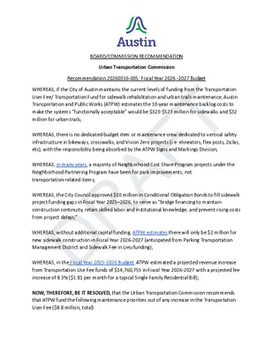
URBAN TRANSPORTATION COMMISSION MEETING MINUTES URBAN TRANSPORTATION COMMISSION REGULAR MEETING MINUTES Monday, March 16, 2026 The Urban Transportation Commission convened in a regular meeting on Monday, March 16, 2026, at Austin Energy Headquarters, Room 1111, Austin, Texas. Vice Chair Schumacher called the Commission Meeting to order at 5:07 p.m. Commissioners in Attendance: Heather Buffo - (District 1) Nathan Fernandes – (District 2) Daniel Kavelman - (District 5) Justin Jacobson - (District 8) Spencer Schumacher, Vice Chair - (District 9) Commissioners in Attendance Virtually: Kevin Chen - (District 6) Deshon Brown (Mayoral) PUBLIC COMMUNICATION Ryan Saunders Zenobia Joseph APPROVAL OF MINUTES 1. Approve the minutes of the URBAN TRANSPORTATION COMMISSION REGULAR MEETING on 2/3/2026. The minutes of the 2/3/2026 meeting were approved on a motion from Commissioner Fernandes, seconded by Commissioner Jacobson, on a 6-0 vote, with Commissioners Brown, Prasad, Somers, and Sorin absent. DISCUSSION ITEMS 2. Transit Enhancement Program Update. The commission received a presentation from Max Schwartz, Program Manager, Austin Transportation and Public Works. 3. Austin Core Transportation Plan Update. The commission received a presentation from Michelle Marx, Transportation Officer, Austin Transportation and Public Works. 4. Austin Transportation and Public Works Services and Budget Update. The commission received a presentation from Richard Mendoza, Director, Austin Transportation and Public Works. 1 URBAN TRANSPORTATION COMMISSION MEETING MINUTES DISCUSSION AND ACTION ITEMS 5. Approve a recommendation regarding the Fiscal Year 2026-20727 budget of Austin Transportation and Public Works. Public Comment Received from Zenobia Joseph On a motion from Commissioner Schumacher, and a second from Commissioner Kavelman approved as amended with a 7-0 vote, with Commissioners Prasad, Somers, and Sorin absent. 6. Approve proposed changes to Urban Transportation Commission By-laws. Amendment: On a motion from Commissioner Schumacher and a second from Commissioner Jacobson, the amendment was approved by a 7-0 vote, with Commissioners Prasad, Somers, and Sorin absent. On a motion from Commissioner Schumacher, and a second from Commissioner Buffo approved as amended with a 7-0 vote, with Commissioners Prasad, Somers, and Sorin absent. COMMITTEE UPDATES 9. Update from Commissioner Chen from the Downtown Commission regarding actions taken at the January 21, 2026, meeting. The commission received an update from Commissioner Chen. 10. Update from Commissioner Prasad from the Joint Sustainability Committee regarding actions taken at the January 28, 2026, meeting. The Item was skipped due to Commissioner Prasad’s absence. 11. Update from Commissioner Schumacher from the Bicycle Advisory Council regarding actions taken …
Citywide Lighting Plan Urban Transportation Commission| 4.7.26 Why are we developing a Lighting Plan? Reduce roadway fatalities and serious injuries Project sponsors Understand what role lighting can play in reducing crime or improving sense of personal safety Improve the safety and utility of urban trails and parks Improve overall nighttime quality of life and Funding urban character Protect sensitive species and reduce light pollution publicinput.com/lightingplan 2 Ongoing interdepartmental collaboration West Campus Lighting Project Mobility Bonds and Federal Grants Slaughter Lane Howard Lane Bluff Springs Road McNeil Drive Pearce Lane 13 high crash intersections Parks and Recreation e.g. park trail / trailhead lighting APD lighting priorities Great Streets Plan update West Campus Lighting Project publicinput.com/lightingplan 3 Scope of work Community engagement Existing conditions analysis Organizational and peer city review New and updated lighting design guidelines Policy recommendations Prioritization framework for new lighting Implementation plan and funding scenarios Scope includes Street and pedestrian lighting in the public right of way Trail lighting Park lighting Scope does not include Privately owned or facade lighting publicinput.com/lightingplan 4 Community and stakeholder engagement Technical Advisory Committee Community Advisory Committee DarkSky Texas, Downtown Austin Alliance, AISD, The Trail Conservancy, Bat Conservation International, SafeHorns, Safe Streets Austin, and many more Night Walk and Lighting 101 presentation Two in-person open houses Project web page Public survey (362 responses) publicinput.com/lightingplan 5 Night Walk with Advisory Committee members Survey findings n=362 Preference for natural, warm, and unobtrusive lighting Reduce light pollution / Dark Sky friendly Promote safety, but not overly bright Clear processes for requesting new lighting or removing existing lighting Latent demand for nighttime walking, biking, trail use, and transit use e.g. 26% of respondents said they would use urban trails more with improved lighting Color Temperature 1000K Candlelight 2000K Tungsten Light 3000K Household Light Bulbs 4000K Natural White 5000K Daylight 6000K Cool White 7000K Overcast 10000K Sky Blue publicinput.com/lightingplan 6 Existing conditions analysis Lighting asset inventory 65,000+ lighting assets reviewed/collected NEW: Urban trails and park lighting inventory Citywide lighting model This data enables Lighting gap analyses Prioritization of new lighting Quantification of potential energy / cost savings Assessment of crash and crime trends …
AN ALLEY RIGHT-OF- WAY VACATION APPLICATION ABUTTING 1909 COMAL STREET Urban Transportation Commission April 7, 2026 Item #5 File #2024-011813 LM District 1 Add location map here Abutting property owner: Board of Regents of the University of Texas System Add aerial picture from property profile generally outline where the vacation area is 1909 Comal Street Unpaved/ Undeveloped Right-of-Way Leona Street E MLK Blvd E 20th Street PICTURES OF PROPERTY STREET VIEW Vacation tract is approximately 0.2399 acres of land All property owners within 300 feet of the vacation area were sent public notices on January 21, 2026. No objections have been received as of the day of this presentation All affected City Departments and external stakeholders have reviewed and recommend approval of this right-of-way vacation application, subject to the conditions on the Master Comment Report submitted with this presentation. The City will retain a Public Utility Easement over the entire vacation area How do you plan to develop the area to be vacated? …will be redeveloped as Graduate Student Housing supporting the students of the University of Texas in Austin. No active site plan. I am happy to answer your questions regarding the right of way process The applicant can answer your questions regarding the abutting property and the proposed development. Thank you for your time! Christopher Bueckert, 512-974-1780 ARMBRUST & BROWN, PLLC A T T O R N E Y S A N D C O U N S E L O R S 100 CONGRESS AVENUE, SUITE 1300 AUSTIN, TEXAS 78701-2744 512-435-2300 FACSIMILE 512-435-2360 Andrew Linseisen (512) 435-2358 alinseisen@abaustin.com Mr. Joseph Fotinos Land Management Division Transportation and Public Works City of Austin 6310 Wilhelmina Delco Drive Austin, Texas 78752 April 9, 2024 Re: Request for Alley Vacation for property located between E. 20th Street and E. Martin Luther King Jr. Boulevard, and between Comal and Leona Streets, Austin, Texas 78722, also known as TCAD Parcel No.’s 0211071501, 0211071502, 0211071503, 0211071504, 0211071505, 0211071506, and 0211071507 (“Tract 1”); 0211071508, 0211071509, 0211071510, 0211071511, 0211071601, 0211071512, and 0211071515 (“Tract 2”); 0211071608, 0211071602, 0211071607, 0211071603, 0211071609, 0211071610 and 0211071611 (“Tract 3”) (collectively the “Property”) Dear Mr. Fotinos: Please accept this as an amended Alley Vacation Application for the above referenced Property (the “Application”). This Application is submitted to request approval of the vacation of the alley while retaining existing easements to the City to accommodate the …
Austin Light Rail April 7, 2026 Urban Transportation Commission Austin Light Rail Phase 1 Light rail is an expandable electric train system designed for metropolitan areas, serving as an integral part of the transit network by connecting people to essential destinations where they live, work and play. ACCESS TO: 136K CURRENT JOBS 200K+ FUTURE JOBS 15 STATIONS connecting north, south and east Austin 9.8 MILES of light rail transit 29K DAILY TRIPS on an average weekday 2 Presentation Title 3 Austin Light Rail Phase 1 Austin Light Rail Timeline 4 Achieving Milestones • Advancing through the Capital Investment Grants program • Received a medium-high rating - the highest rating awarded by the Federal Transit Administration in the Fiscal Year 2026 cycle • Completed the NEPA Final Environmental Impact Statement in January 2026, the first major New Starts project to do so within the required 2-year deadline • 2026: Awarding Contracts to Build Austin Light Rail • February: ATP Board awards final design & construction contract to Austin Rail Constructors • Spring: ATP Board expected to award contract for construction of Operations & Maintenance Facility • Summer: ATP Board expected to award contract for light rail vehicles 5 Contracts to be Awarded in 2026 Civils, Rail, Stations, Systems Operations & Maintenance Facility Light Rail Vehicles • Progressive Design-Build • Progressive Design-Build • Summer 2026 Award • February 18th Board Award to Austin Rail Constructors • Phase 1: Preconstruction (continuing design and planning) • Phase 2: Construction • Q2 2026 Award • Phase 1: Preconstruction (continuing design and planning) • Phase 2: Construction • Design coordination with design-build teams • Vehicle design and manufacturing 6 What is Progressive Design-Build? A collaborative construction method where the owner works with the designer & builder from an early stage Helps identify opportunities for innovation and optimization Reduces and manages risks by having all parties at the table at an earlier stage Frequent and early collaboration enhances efficiency and timeliness of delivery 7 LRT Contractor Preconstruction Overview Pre-Construction Activities 2026 Preconstruction (1A): Design Progression & Construction Planning 2027 2028 … 2/18/2026 Board Authorization Preconstruction (1B): Final Design & Permitting Board Authorization to finish final design Construction Packages Board Authorization for Construction Packages Preconstruction (1A): Design Progression & Construction Planning • Advance design and initiate permitting • Field work and utility coordination Preconstruction (1B): Final Design & Permitting • Advance design and refine construction cost estimates to …
2025 CENTRAL TEXAS COMMUTER SURVEY 1 AUSTIN STRATEGIC MOBILITY PLAN (ASMP) 2019 2039 74% drive-alone to work/school 26% use an active/shared mode 50% drive-alone to work/school 50% use an active/shared mode 2 2025 CENTRAL TEXAS COMMUTER SURVEY • Conducted 2025 Annual Commuter Survey, supported by the ETC Institute • Surveyed 1874 residents in Travis, Hays, Williamson, Caldwell, Burnet, and Bastrop Counties o Added 3 new counties since last year o 95% confidence level o 45% work from home some of the time o 91% are currently employed full-time or part-time 3 HOW ARE WE DOING? 2025 All 6 Counties 4 WHAT’S CHANGED SINCE 2024? 2024 2025 (3-county region) 68% drive-alone to work/school 14% use an active/shared mode 68% drive-alone to work/school 16% use an active/shared mode 5 WHAT’S CHANGED SINCE 2024? Central Texas is still progressing towards its 50-50 goal. Carpooling +96% Drive-alone No change Telework -19% Rideshare +239% (0.77% -> 2.61%) Transit No change Biking -40% (3.01% -> 1.80%) 6 KEY FINDINGS 1) Continue investing in Williamson County transit services. • Williamson County transit ridership (7.68%) • Second highest after Travis County (14.48%) • Six county region avg. transit ridership (6.51%) 7 KEY FINDINGS 2) When employers subsidize active/shared modes, more people use them. • Employees with subsidies are 19% more likely to take active/shared modes • Only 8% of people have access to subsidies for active/shared modes • People w/o free parking and parking reimbursement also had high rates 8 KEY FINDINGS 3) Telework alone isn’t the answer • Teleworking decreased by 19% from 2024 to • 2025 Increase of return to office mandates and hybrid work schedules • Not available to essential workers • Average commute distance 11.59 miles 9 KEY FINDINGS 4) Hispanic participation and representation in biking (ebike/bike) has improved in 2025 • Asian (5%) and Black (6%) biking rates are low compared to representative sample 10 KEY FINDINGS 5) Higher incomes/education associated with higher active and shared mode usage • People with >$200k HHI had a high active/shared mode usage (42%) • Individuals with <$15k HHI had the second highest usage rate (39%) and a high train ridership rate • People with a graduate degree or higher also had a high usage rate (39%) • People in child-rearing years (25-44) were the least likely to use active/shared modes 11 THANK YOU! 2025 CENTRAL TEXAS COMMUTER SURVEY 12
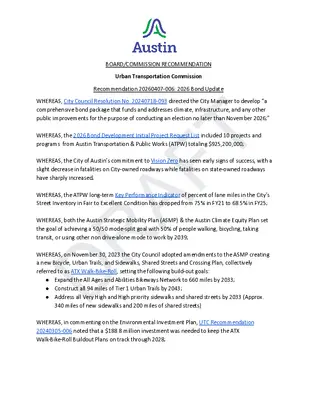
BOARD/COMMISSION RECOMMENDATION Urban Transportation Commission Recommendation 20260407-006: 2026 Bond Update WHEREAS, the 2026 Bond Development Initial Project Request List included 10 projects and programs from Austin Transportation & Public Works (ATPW) totaling $925,200,000; WHEREAS, the ATPW long-term Key Performance Indicator of percent of lane miles in the City’s Street Inventory in Fair to Excellent Condition has dropped from 75% in FY21 to 68.5% in FY25; WHEREAS, the City of Austin’s commitment to Vision Zero has seen early signs of success, with a slight decrease in fatalities on City-owned roadways while fatalities on state-owned roadways have sharply increased; WHEREAS, City Council Resolution No. 20240718-093 directed the City Manager to develop “a comprehensive bond package that funds and addresses climate, infrastructure, and any other public improvements for the purpose of conducting an election no later than November 2026;” DRAFT ● Expand the All Ages and Abilities Bikeways Network to 660 miles by 2033; ● Construct all 94 miles of Tier 1 Urban Trails by 2043; ● Address all Very High and High priority sidewalks and shared streets by 2033 (Approx. WHEREAS, on November 30, 2023 the City Council adopted amendments to the ASMP creating a new Bicycle, Urban Trails, and Sidewalks, Shared Streets and Crossing Plan, collectively referred to as ATX Walk-Bike-Roll, setting the following build-out goals: WHEREAS, both the Austin Strategic Mobility Plan (ASMP) & the Austin Climate Equity Plan set the goal of achieving a 50/50 mode-split goal with 50% of people walking, bicycling, taking transit, or using other non drive-alone mode to work by 2039; 340 miles of new sidewalks and 200 miles of shared streets) WHEREAS, in commenting on the Environmental Investment Plan, UTC Recommendation 20240305-006 noted that a $188.8 million investment was needed to keep the ATX Walk-Bike-Roll Buildout Plans on track through 2028; WHEREAS, funding from previous bonds allocated toward named projects, such as the Dougherty Arts Center and the various Corridors projects, has been underspent and not resulted in comparable results to programmatically defined bond funding; WHEREAS, transportation represents the largest share of Austin’s greenhouse gas emissions, and thus presents the greatest opportunity for climate investment; WHEREAS, on January 21, 2026, the Project Review Board proposed an initial draft with a $251,000,000 transportation bond (see Appendix A); WHEREAS, the Bond Election Advisory Task Force Transportation & Electrification Working Group proposed a $300,000,000 transportation and electrification bond (see Appendix A); NOW, THEREFORE, BE IT RESOLVED, that …
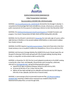
BOARD/COMMISSION RECOMMENDATION Urban Transportation Commission Recommendation 20260407-006: 2026 Bond Update WHEREAS, City Council Resolution No. 20240718-093 directed the City Manager to develop “a comprehensive bond package that funds and addresses climate, infrastructure, and any other public improvements for the purpose of conducting an election no later than November 2026;” WHEREAS, the 2026 Bond Development Initial Project Request List included 10 projects and programs from Austin Transportation & Public Works (ATPW) totaling $925,200,000; WHEREAS, the City of Austin’s commitment to Vision Zero has seen early signs of success, with a slight decrease in fatalities on City-owned roadways while fatalities on state-owned roadways have sharply increased; WHEREAS, the ATPW long-term Key Performance Indicator of percent of lane miles in the City’s Street Inventory in Fair to Excellent Condition has dropped from 75% in FY21 to 68.5% in FY25; WHEREAS, both the Austin Strategic Mobility Plan (ASMP) & the Austin Climate Equity Plan set the goal of achieving a 50/50 mode-split goal with 50% of people walking, bicycling, taking transit, or using other non drive-alone mode to work by 2039; WHEREAS, on November 30, 2023 the City Council adopted amendments to the ASMP creating a new Bicycle, Urban Trails, and Sidewalks, Shared Streets and Crossing Plan, collectively referred to as ATX Walk-Bike-Roll, setting the following build-out goals: ● Expand the All Ages and Abilities Bikeways Network to 660 miles by 2033; ● Construct all 94 miles of Tier 1 Urban Trails by 2043; ● Address all Very High and High priority sidewalks and shared streets by 2033 (Approx. 340 miles of new sidewalks and 200 miles of shared streets) WHEREAS, in commenting on the Environmental Investment Plan, UTC Recommendation 20240305-006 noted that a $188.8 million investment was needed to keep the ATX Walk-Bike-Roll Buildout Plans on track through 2028; WHEREAS, funding from previous bonds allocated toward named projects, such as the Dougherty Arts Center and the various Corridors projects, has been underspent and not resulted in comparable results to programmatically defined bond funding; WHEREAS, transportation represents the largest share of Austin’s greenhouse gas emissions, and thus presents the greatest opportunity for climate investment; WHEREAS, in Recommendation 20251202-005, the Urban Transportation Commission (UTC) recommended the Bond Advisory Task Force and the Project Review Board advance a $331,200,000 transportation bond, focusing investments in safety, ATX Walk-Bike-Roll, and roadway conditions. WHEREAS, the Bond Election Advisory Task Force Transportation & Electrification Working Group proposed a $300,000,000 transportation …
URBAN TRANSPORTATION COMMISSION MEETING MINUTES URBAN TRANSPORTATION COMMISSION REGULAR MEETING MINUTES Tuesday, April 7, 2026 The Urban Transportation Commission convened in a regular meeting on Tuesday, April 7, 2026, at Austin City Hall, Boards and Commissions Room 1101, Austin, Texas. Chair Somers called the Commission Meeting to order at 5:06 p.m. Commissioners in Attendance: Susan Somers - (District 4) Nathan Fernandes – (District 2) Spencer Schumacher, Vice Chair - (District 9) Commissioners in Attendance Virtually: Heather Buffo - (District 1) Daniel Kavelman - (District 5) Varun Prasad, - (District 7) Justin Jacobson - (District 8) Deshon Brown (Mayoral) PUBLIC COMMUNICATION Scott Johnson APPROVAL OF MINUTES 1. Approve the minutes of the URBAN TRANSPORTATION COMMISSION SPECIAL CALLED MEETING on 3/16/2026. The minutes of the 3/16/2026 meeting were approved on a motion from Commissioner Schumacher, seconded by Commissioner Fernandes, on a 7-0 vote, with Commissioners Chen, Jacobson and Sorin absent. DISCUSSION ITEMS 2. Project Connect Update, including the Federal Transit Administration record of decision for Austin Light Rail Phase 1. The commission received presentations from Jennifer Pyne, EVP, Planning, Community & Federal Programs, and Lindsay Wood, EVP, Engineering & Construction, Austin Transit Partnership. 3. Austin Core Transportation Plan Update. Movability Commuter Survey update The commission received a presentation from Kathleen Lu, Movability. 4. Citywide Lighting Plan update. 1 URBAN TRANSPORTATION COMMISSION MEETING MINUTES The commission received a presentation from Joel Meyer, Transportation Officer, Austin Transportation and Public Works. DISCUSSION AND ACTION ITEMS 5. Approve the Right of Way Vacation for 2024-011813 LM - 1909 Comal Street The commission received a presentation from Christopher Bueckert, Real Estate Services Agent, Austin Transportation and Public Works. On a motion from Commissioner Kavelman, and a second from Commissioner Schumacher approved with an 8-0 vote, with Commissioners Chen and Sorin absent. 6. Approve a recommendation to Council regarding the 2026 Bond Program. On a motion from Commissioner Schumacher, and a second from Commissioner Fernandes approved with an 8-0 vote, with Commissioners Chen and Sorin absent. 7. Approve officer appointments to the Urban Transportation Commission. On a motion from Commissioner Schumacher, and a second from Commissioner Kavelman, the office of Chair was approved as Commissioner Somers with an 8-0 vote, with Commissioners Chen and Sorin absent. On a motion from Commissioner Somers, and a second from Commissioner Fernandes, the office of Vice Chair was approved as Commissioner Schumacher with an 8-0 vote, with Commissioners Chen and Sorin absent. …
SPECIAL CALLED MEETING OF THE URBAN TRANSPORTATION COMMISSION MONDAY, MARCH 16, 2026, AT 5:00 P.M. AUSTIN ENERGY HEADQUARTERS, ROOM 1111 4815 MUELLER BLVD. AUSTIN, TEXAS Some members of the Urban Transportation Commission may be participating by videoconference. The meeting may be viewed online at: http://www.austintexas.gov/page/watch-atxn-live Public comment will be allowed in-person or remotely via telephone. Speakers may only register to speak on an item once, either in person or remotely, and will be allowed up to three minutes to provide their comments. Registration no later than noon the day before the meeting is required for remote participation by telephone. To register to speak remotely, contact Natalie Leone, 512-974- 3428, natalie.leone@austintexas.gov. CURRENT COMMISSIONERS: Susan Somers, Chair Daniel Kavelman, Parliamentarian Deshon Brown Heather Buffo Kevin Chen Nathan Fernandes Justin Jacobson Varun Prasad Joshua Sorin Spencer Schumacher, Vice Chair AGENDA CALL TO ORDER PUBLIC COMMUNICATION: GENERAL The first 5 speakers signed up prior to the meeting being called to order will each be allowed a three- minute allotment to address their concerns regarding items not posted on the agenda. APPROVAL OF MINUTES 1. Approve the minutes of the Urban Transportation Commission Regular meeting on 2/3/2026. DISCUSSION ITEMS 2. 3. 4. Transit Enhancement Program Update. Presentation by Max Schwartz, Program Manager, Austin Transportation and Public Works. Austin Core Transportation Plan Update. Presentation by Michelle Marx, Transportation Officer, and Cole Kitten, Division Manager, Austin Transportation and Public Works. Austin Transportation and Public Works Services and Budget Update. Presentation by Richard Mendoza, Director, Austin Transportation and Public Works. DISCUSSION AND ACTION ITEMS 5. 6. Approve a recommendation regarding the Fiscal Year 2026-20727 budget of Austin Transportation and Public Works. Approve proposed changes to Urban Transportation Commission By-laws. COMMITTEE UPDATES 7. 8. 9. 10. 11. 12. Update from Commissioner Chen from the Downtown Commission regarding actions taken at the February 18, 2026, meeting. Update from Commissioner Prasad from the Joint Sustainability Committee regarding actions taken at the February 25, 2026, meeting. Update from Commissioner Schumacher from the Bicycle Advisory Council regarding actions taken at the February 17, 2026, meeting. Update from Commissioner Kavelman from the Pedestrian Advisory Council regarding actions taken at the February 2, 2026, and March 2, 2026, meetings. Update from Chair Somers from the City Council Mobility Committee regarding actions taken at the February 12, 2026, meeting. Update from Chair Somers from the Community Advisory Committee of the Austin Transit Partnership Board regarding actions …
URBAN TRANSPORTATION COMMISSION MEETING MINUTES URBAN TRANSPORTATION COMMISSION REGULAR MEETING MINUTES Tuesday, February 3, 2026 The Urban Transportation Commission convened in a regular meeting on Tuesday, February 3, 2026, at Austin City Hall, Boards and Commissions Room 1101, Austin, Texas. Chair Somers called the Commission Meeting to order at 5:02 p.m. Commissioners in Attendance: Heather Buffo - (District 1) Nathan Fernandes – (District 2) Susan Somers, Chair - (District 4) Daniel Kavelman - (District 5) Spencer Schumacher, Vice Chair - (District 9) Commissioners in Attendance Virtually: Kevin Chen - (District 6) Justin Jacobson - (District 8) Deshon Brown (Mayoral) PUBLIC COMMUNICATION Philip Wiley Santiago APPROVAL OF MINUTES 1. Approve the minutes of the URBAN TRANSPORTATION COMMISSION REGULAR MEETING on 1/6/2026. The minutes from the meeting of 1/6/2026 were approved on a motion from Chair Somers, seconded by Vice Chair Schumacher, on an 8-0 vote, with Commissioners Prasad and Sorin absent. DISCUSSION ITEMS 2. Long Range Population Forecasting. The commission received a presentation from Genest Lila Valencia, City Demographer, Austin Planning. 3. Curb Management Study. The commission received a presentation from Lewis Leff, Assistant Director, and Joseph Al-Hajeri, Parking Enterprise Manager, both from Austin Transportation and Public Works. 1 URBAN TRANSPORTATION COMMISSION MEETING MINUTES 4. Sixth Street Design. The commission received a presentation from Anna Martin, Assistant Director, Austin Transportation and Public Works. DISCUSSION AND ACTION ITEMS 5. Approve a recommendation to Council on Sixth Street Rebuild. Amendment 1: On a motion from Commissioner Kavelman, and a second from Commissioner Fernandes, the amendment was approved with a 7-0 vote, with Commissioners Jacobson, Prasad and Sorin absent. Amendment 2: On a motion from Commissioner Schumacher, and a second from Commissioner Somers, the amendment was approved with a 7-0 vote, with Commissioners Jacobson, Prasad and Sorin absent. Amendment 3: On a motion from Commissioner Buffo, and a second from Commissioner Schumacher, the amendment failed with a 4-3 vote, with Commissioners Jacobson, Prasad and Sorin absent. On a motion from Commissioner Kavelman, and a second from Commissioner Schumacher approved as amended with a 7-0 vote, with Commissioners Jacobson, Prasad and Sorin absent. 6. Approve a recommendation to Council regarding the Central Texas Regional Mobility Authority (CTRMA) South Mopac project. On a motion from Commissioner Kavelman, and a second from Commissioner Somers, approved as amended with a 7-0 vote, with Commissioners Jacobson, Prasad and Sorin absent. 7. Approve proposed changes to Urban Transportation Commission By-laws. …
BYLAWS OF THE Urban Transportation Commission ARTICLE 1. NAME. The name of the board is: Urban Transportation Commission. ARTICLE 2. PURPOSE AND DUTIES. The purpose and duties of the board are as follows: transportation energy conservation matters grant applications; • • streets and highways; • bus and rail service; • pedestrian and bikeway programs and projects; • safety related programs and projects; • provision for the needs of the mobility impaired; • transportation franchise requests, renewals, rate adjustments, and hours of operation. The commission shall: • Review and make recommendations to the city council on all requests for taxicab permits, including annual permits and franchise permits. • Annually review and report to the city council on the City's transportation system, including policies and programs. • Review, study, and make recommendations to the Planning Commission on: transportation-related projects proposed for inclusion in the Capital Improvements Program; and plans and programs submitted by the Capital Area Metropolitan Planning Organization. • Receive and study public comments and suggestions in all areas of transportation. • In its deliberations: (1) recognize the relationship between transportation and economics, energy, safety, land use, neighborhood integrity, and environmental quality; and (2) consider transportation access to health care, employment, education, housing, and recreational facilities. • Seek to promote close cooperation between the city council, other city boards and commissions, city departments, and individuals, institutions, and agencies concerned with transportation-related activities so that all similar activities in the City may be coordinated to secure the greatest public welfare. • Perform any other duties assigned by City Council. ARTICLE 3. MEMBERSHIP. (A) The board is composed of eleven members appointed by the city council. (B) A member serves at the pleasure of the city council. (C) Board members serve for a term of four years beginning March 1st on the year of appointment. (D) An individual board member may not act in an official capacity or speak on behalf of the board except through the action of a majority of the board in which the board identifies who is authorized to speak and identifies the actions the individual board member is authorized to take or topics on which the individual board member is entitled to speak. (E) A board member who is absent for three consecutive regular meetings or one-third of all regular meetings in a “rolling” twelve month timeframe automatically vacates the member’s position subject to the holdover provisions in …
ACT Plan Update Urban Transportation Commission Austin Transportation and Public Works | March 16, 2026 ACT Plan Purpose The ACT Plan is a Small Area Mobility Plan (SAMP) covering Downtown Austin and will be adopted by Council as an attachment to the ASMP It is an update to previous transportation focused efforts Downtown – dating back to 2000 Why are we updating the transportation plan for Downtown? changes in transit and bicycle planning changes in highway improvements serving Downtown changes in national best practices on urban street design disruptions to traditional mobility The ACT Plan will create a unified vision for transportation Downtown and align the many projects and initiatives under one actionable plan to help accomplish the goals in the Austin Strategic Mobility Plan. 2 2 ACT Plan Process 2018 - Phase 1 data collection effort 2019 - Phase 2 plan development 2020 - Planning put on hold 2022 - Planning recommences August - October 2022 - Public Engagement Phase 1 November 2022-March 2023 - Public Engagement Phase 2 September 2022-December 2024 - Project and Plan Development February-May 2025 - Draft Plan Review & Public Engagement Phase 3 (Council adoption postponed) June 2025-March 2026 - Revised Final Draft Plan & Council adoption process 3 Public Engagement Worked with Downtown Austin Alliance to form a project Working Group Identified more than 80 Downtown stakeholders Held public events, pop-ups, community meetings, and online surveys throughout downtown and outside of downtown Integrated with other Downtown focused projects and programs (e.g., Palm District, Project Connect, etc.) Identified more than 20 different focus populations to ensure diverse feedback 4 4 Plan Review Timeline February 24, 2025 – Design Commission March 4, 2025 – Urban Transportation Commission March 11, 2025 – Planning Commission March 20, 2025 – Council Mobility Committee March 26, 2025 – Joint Sustainability Committee February 18, 2026 – Downtown Commission March 3, 2026 – Urban Transportation Commission March 5, 2026 – Council Mobility Committee March 26, 2026 – City Council 5 What We Heard Support for pedestrian-first, human-centered design elements Support for current and future transit-priority lanes and protected bike lanes Support for quick build options at lower cost for more facilities in the short term Provide …
Transit Enhancement Program Update Austin Transportation and Public Works | March 16, 20216 Max E. Schwartz AICP, PTP – Capital Improvement Program Manager Agenda ▪ Program Background ▪ Program Overview ▪ Program Accomplishments ▪ Future Work 2 Program Background ▪ Program Mission ▪ Inter-local Agreement with CapMetro 3 Program Background Transit Supportive Plans & Policies 4 Program Background Transit Supportive Plans & Policies ~$50 million of transit work identified in report. 5 Program Background Transit Enhancement History ▪ 2015 – CapMetro and Transportation and Public Works (TPW) staff meet bi-weekly as the Transit Priority Working Group ▪ 2018 – Interlocal agreement (ILA) signed between CapMetro and City for design and construction of operations, access and safety improvements ▪ 2019 – City Council adopts the Austin Strategic Mobility Plan (ASMP), including specific policy objectives to support transit ▪ 2020 – Austin voters approve the 2020 Safety and Active Transportation Bond, including $19M for Transit Enhancement projects ▪ 2021 – Austin’s updated Transportation Criteria Manual (TCM) is approved by Council, including a chapter dedicated to transit ▪ 2023 – TPW finalizes the Transit Enhancement Infrastructure Report 6 Program Overview Partnering to Improve Transit Operations Improvement Access Improvement Project Coordination 7 Program Overview Work Categories 8 Program Accomplishments 1 Transit Enhancement Infrastructure Report 2+ miles of Transit Priority Lanes 5 Transit Queue Jump Signals 66 Access Improvements 82 Bus Stop Upgrades 9 Program Accomplishments 2020 Bond Allocation $19 Million Total 2.73M, Unencumbered Estimated Completion: End of FY 27 $0.9M Set Aside CAMPO Grants/SS4A $1.07 M In Design $3.2M In Construction $11.1 M, Spent 10 Project Highlights Transit Priority Lanes Guadalupe Infill E 12th and Airport 11 Project Highlights Transit Priority Lanes Trinity and San Jacinto - MetroRapid Support 12 Thank you Program Team Richard Mendoza P.E., M.P.A Director Jim Dale P.E. Deputy Director Anna Martin P.E. Assistant Director Eric Bollich P.E., PTOE Managing Engineer Max Schwartz AICP, PTP Capital Improvement Program Manager Daniil Kontsevoy Capital Improvement Program Manager 13
ACT Plan Update Urban Transportation Commission Austin Transportation and Public Works | March 16, 2026 ACT Plan Purpose The ACT Plan is a Small Area Mobility Plan (SAMP) covering Downtown Austin and will be adopted by Council as an attachment to the ASMP It is an update to previous transportation focused efforts Downtown – dating back to 2000 Why are we updating the transportation plan for Downtown? changes in transit and bicycle planning changes in highway improvements serving Downtown changes in national best practices on urban street design disruptions to traditional mobility The ACT Plan will create a unified vision for transportation Downtown and align the many projects and initiatives under one actionable plan to help accomplish the goals in the Austin Strategic Mobility Plan. 2 2 ACT Plan Process 2018 - Phase 1 data collection effort 2019 - Phase 2 plan development 2020 - Planning put on hold 2022 - Planning recommences August - October 2022 - Public Engagement Phase 1 November 2022-March 2023 - Public Engagement Phase 2 September 2022-December 2024 - Project and Plan Development February-May 2025 - Draft Plan Review & Public Engagement Phase 3 (Council adoption postponed) June 2025-March 2026 - Revised Final Draft Plan & Council adoption process 3 Public Engagement Worked with Downtown Austin Alliance to form a project Working Group Identified more than 80 Downtown stakeholders Held public events, pop-ups, community meetings, and online surveys throughout downtown and outside of downtown Integrated with other Downtown focused projects and programs (e.g., Palm District, Project Connect, etc.) Identified more than 20 different focus populations to ensure diverse feedback 4 4 Plan Review Timeline February 24, 2025 – Design Commission March 4, 2025 – Urban Transportation Commission March 11, 2025 – Planning Commission March 20, 2025 – Council Mobility Committee March 26, 2025 – Joint Sustainability Committee February 18, 2026 – Downtown Commission March 3, 2026 – Urban Transportation Commission March 5, 2026 – Council Mobility Committee March 26, 2026 – City Council 5 What We Heard Support for pedestrian-first, human-centered design elements Support for current and future transit-priority lanes and protected bike lanes Support for quick build options at lower cost for more facilities in the short term Provide …
Austin Transportation and Public Works Services and Budget Urban Transportation Commission March 3, 2026 Austin Transportation & Public Works We are a highly reliable organization that builds and maintains mobility infrastructure for our community. Responsible for a wide range of transportation, mobility, and safety functions across the community Works with all modes of transportation and numerous Austin-area partners and agencies Ensures the transportation system is safe, reliable, and well-maintained By the Numbers $240+ million operating budget 1000+ employees 7 service areas 2 Our Network 7,979 lane miles of streets 1,216 traffic signals 75 miles of alleys 101 pedestrian hybrid beacons 4,000 miles curb and gutter 784 CCTV cameras 466 major bridges 810 culverts and pipes 20 pedestrian bridges 197,038 traffic signs 980 centerline miles of longline 6,900 crosswalks 2,900 miles of sidewalks 41,600 specialty markings 458 miles of bike lanes 139 miles of urban trails 300,000 trees 313 acres mowed + more! 3 Mobility Impacts to the Community Safe and Reliable Infrastructure • Street network • Crosswalks • Bridges • Sidewalks • Traffic Signals Accessible Mobility Options • Effective traffic signage and wayfinding • Expanding urban trail system • Bicycle infrastructure for all ages and abilities • Sufficient crossing guards at Austin schools • Crosswalks near libraries, parks, & bus stops 4 Our Structure Richard Mendoza Director Jim Dale Deputy Director Business Support Services Office of the Director Street and Bridge Operations Transportation Engineering Services Transportation Operations Services Civil Engineering Services Transportation Planning Finance • • Human Resources • Data & Technology Services • Performance Management Equity • • Public Information • District Office • Administration • Legislative Affairs Maintenance • Utilities & Structures • Pavement Operations Infrastructure Operations • • Transportation Engineering • Project Delivery • Active Transportation • Vision Zero • Signs and Markings • Arterial Management • Urban Forestry • Parking Enterprise • • Office of the City Engineer Sidewalks and Urban Trails • Community Services Emergency Management Logistics • • Strategic Projects Systems Development • • • Right of Way • Office of Special Events • Transportation Development Services Land Development Engineering • 5 ATPW Funding Sources Operating Budget Funding Source Description Proper Use Transportation User Fee (TUF) Based on land use type and trip generation (estimated $21.80 / month per household in FY26) Operations and maintenance of mobility assets and small-scale capital investments Temporary Use of Right-of-Way (TURP) Based on amount of …
BOARD/COMMISSION RECOMMENDATION Urban Transportation Commission Recommendation 20260316-005: Fiscal Year 2026 -2027 Budget WHEREAS, in many years, a majority of Neighborhood Cost Share Program projects under the Neighborhood Partnering Program have been for park improvements, not transportation-related items; WHEREAS, there is no dedicated budget item or maintenance crew dedicated to vertical safety infrastructure in bikeways, crosswalks, and Vision Zero projects (i.e. elineators, flex posts, Ziclas, etc), with the responsibility being absorbed by the ATPW Signs and Markings Division; WHEREAS, if the City of Austin maintains the current levels of funding from the Transportation User Fee/ Transportation Fund for sidewalk rehabilitation and urban trails maintenance, Austin Transportation and Public Works (ATPW) estimates the 10-year maintenance backlog costs to make the systems “functionally acceptable” would be $323-$523 million for sidewalks and $32 million for urban trails; DRAFT WHEREAS, the City Council approved $10 million in Conditional Obligation Bonds to fill sidewalk project funding gaps in Fiscal Year 2025–2026, to serve as “bridge financing to maintain construction continuity, retain skilled labor and institutional knowledge, and prevent rising costs from project delays;” WHEREAS, in the Fiscal Year 2025-2026 Budget, ATPW estimated a projected revenue increase from Transportation Use Fee funds of $14,760,755 in Fiscal Year 2026-2027 with a projected fee increase of 8.3% ($1.81 per month for a typical Single Family Residential Bill); WHEREAS, without additional capital funding, ATPW estimates there will only be $2 million for new sidewalk construction in Fiscal Year 2026-2027 (anticipated from Parking Transportation Management District and Sidewalk Fee in Lieu funding); NOW, THEREFORE, BE IT RESOLVED, that the Urban Transportation Commission recommends that ATPW fund the following maintenance priorities out of any increase in the Transportation User Fee ($8.8 million, total): ● $15.4 million in sidewalk rehabilitation, a 100% increase from $7.7 million in FY 26, to reduce the 10-year backlog of sidewalk rehabilitation projects from $323-$523 million (at existing funding levels) to $246-446 million (31%- 14.7% reduction); ● $1 million in urban trails maintenance, a 150% increase from $0.4 million in FY 26, to reduce the 10-year backlog in Urban Trail repair needs from $32 million (at existing funding levels) to $22 million (31% reduction) ○ If ATPW feels this is already budgeted within Signs & Markings, the UTC recommends that the funding be broken out as a separate budget item within the division; ● $0.5 million and a dedicated maintenance crew for Vertical Safety to replace and repair …
BOARD/COMMISSION RECOMMENDATION Urban Transportation Commission Recommendation 20260316-005: Fiscal Year 2026 -2027 Budget WHEREAS, if the City of Austin maintains the current levels of funding from the Transportation User Fee/ Transportation Fund for sidewalk rehabilitation and urban trails maintenance, Austin Transportation and Public Works (ATPW) estimates the 10-year maintenance backlog costs to make the systems “functionally acceptable” would be $323-$523 million for sidewalks and $32 million for urban trails; WHEREAS, there is no dedicated budget item or maintenance crew dedicated to vertical safety infrastructure in bikeways, crosswalks, and Vision Zero projects (i.e. delineators, flex posts, Ziclas, etc), with the responsibility being absorbed by the ATPW Signs and Markings Division; WHEREAS, in many years, a majority of Neighborhood Cost Share Program projects under the Neighborhood Partnering Program have been for park improvements, not transportation-related items; WHEREAS, the City Council approved $10 million in Conditional Obligation Bonds to fill sidewalk project funding gaps in Fiscal Year 2025–2026, to serve as “bridge financing to maintain construction continuity, retain skilled labor and institutional knowledge, and prevent rising costs from project delays;” WHEREAS, without additional capital funding, ATPW estimates there will only be $2 million for new sidewalk construction in Fiscal Year 2026-2027 (anticipated from Parking Transportation Management District and Sidewalk Fee in Lieu funding); WHEREAS, in the Fiscal Year 2025-2026 Budget, ATPW estimated a projected revenue increase from Transportation Use Fee funds of $14,760,755 in Fiscal Year 2026-2027 with a projected fee increase of 8.3% ($1.81 per month for a typical Single Family Residential Bill); NOW, THEREFORE, BE IT RESOLVED, that the Urban Transportation Commission recommends that ATPW fund the following maintenance priorities out of any increase in the Transportation User Fee (increase of $8.8 million, above FY 2025-2026 levels): ● $15.4 million in sidewalk rehabilitation, an increase from $7.7 million in FY 26, to reduce the 10-year backlog of sidewalk rehabilitation projects from $323-$523 million (at existing funding levels) to $246-446 million (31%- 14.7% reduction); ● $1 million in urban trails maintenance, an increase from $0.4 million in FY 26, to reduce the 10-year backlog in Urban Trail repair needs from $32 million (at existing funding levels) to $22 million (31% reduction) ● $0.5 million and a dedicated maintenance crew for Vertical Safety to replace and repair broken delineators, flex posts, Ziclas, and other vertical safety elements in bikeways, crosswalks, and Vision Zero projects; and ○ If ATPW feels this is already budgeted within …
URBAN TRANSPORTATION COMMISSION MEETING MINUTES URBAN TRANSPORTATION COMMISSION SPECIAL CALLED MEETING MINUTES Monday, March 16, 2026 The Urban Transportation Commission convened in a special called meeting on Monday, March 16, 2026, at Austin Energy Headquarters, Room 1111, Austin, Texas. Vice Chair Schumacher called the Commission Meeting to order at 5:07 p.m. Commissioners in Attendance: Heather Buffo - (District 1) Nathan Fernandes – (District 2) Daniel Kavelman - (District 5) Justin Jacobson - (District 8) Spencer Schumacher, Vice Chair - (District 9) Commissioners in Attendance Virtually: Kevin Chen - (District 6) Deshon Brown (Mayoral) PUBLIC COMMUNICATION Ryan Saunders Zenobia Joseph APPROVAL OF MINUTES 1. Approve the minutes of the URBAN TRANSPORTATION COMMISSION REGULAR MEETING on 2/3/2026. The minutes of the 2/3/2026 meeting were approved on a motion from Commissioner Fernandes, seconded by Commissioner Jacobson, on a 6-0 vote, with Commissioners Brown, Prasad, Somers, and Sorin absent. DISCUSSION ITEMS 2. Transit Enhancement Program Update. The commission received a presentation from Max Schwartz, Program Manager, Austin Transportation and Public Works. 3. Austin Core Transportation Plan Update. The commission received a presentation from Michelle Marx, Transportation Officer, Austin Transportation and Public Works. 4. Austin Transportation and Public Works Services and Budget Update. The commission received a presentation from Richard Mendoza, Director, Austin Transportation and Public Works. 1 URBAN TRANSPORTATION COMMISSION MEETING MINUTES DISCUSSION AND ACTION ITEMS 5. Approve a recommendation regarding the Fiscal Year 2026-20727 budget of Austin Transportation and Public Works. Public Comment Received from Zenobia Joseph On a motion from Commissioner Schumacher, and a second from Commissioner Kavelman approved as amended with a 7-0 vote, with Commissioners Prasad, Somers, and Sorin absent. 6. Approve proposed changes to Urban Transportation Commission By-laws. Amendment: On a motion from Commissioner Schumacher and a second from Commissioner Jacobson, the amendment was approved by a 7-0 vote, with Commissioners Prasad, Somers, and Sorin absent. On a motion from Commissioner Schumacher, and a second from Commissioner Buffo approved as amended with a 7-0 vote, with Commissioners Prasad, Somers, and Sorin absent. COMMITTEE UPDATES 9. Update from Commissioner Chen from the Downtown Commission regarding actions taken at the January 21, 2026, meeting. The commission received an update from Commissioner Chen. 10. Update from Commissioner Prasad from the Joint Sustainability Committee regarding actions taken at the January 28, 2026, meeting. The Item was skipped due to Commissioner Prasad’s absence. 11. Update from Commissioner Schumacher from the Bicycle Advisory Council regarding …
REGULAR MEETING OF THE URBAN TRANSPORTATION COMMISSION TUESDAY, MARCH 3, 2026, AT 5:00 P.M. CITY HALL, ROOM 1101 301 WEST SECOND STREET AUSTIN, TEXAS Some members of the Urban Transportation Commission may be participating by videoconference. The meeting may be viewed online at: http://www.austintexas.gov/page/watch-atxn-live Public comment will be allowed in-person or remotely via telephone. Speakers may only register to speak on an item once, either in person or remotely, and will be allowed up to three minutes to provide their comments. Registration no later than noon the day before the meeting is required for remote participation by telephone. To register to speak remotely, contact Natalie Leone, 512-974- 3428, natalie.leone@austintexas.gov. CURRENT COMMISSIONERS: Susan Somers, Chair Daniel Kavelman, Parliamentarian Deshon Brown Heather Buffo Kevin Chen Nathan Fernandes Justin Jacobson Varun Prasad Joshua Sorin Spencer Schumacher, Vice Chair AGENDA CALL TO ORDER PUBLIC COMMUNICATION: GENERAL The first 5 speakers signed up prior to the meeting being called to order will each be allowed a three- minute allotment to address their concerns regarding items not posted on the agenda. APPROVAL OF MINUTES 1. Approve the minutes of the Urban Transportation Commission Regular meeting on 2/3/2026. DISCUSSION ITEMS 2. 3. 4. Transit Enhancement Program Update. Presentation by Max Schwartz, Program Manager, Austin Transportation and Public Works. Austin Core Transportation Plan Update. Presentation by Michelle Marx, Transportation Officer, and Cole Kitten, Division Manager, Austin Transportation and Public Works. Austin Transportation and Public Works Services and Budget Update. Presentation by Richard Mendoza, Director, Austin Transportation and Public Works. DISCUSSION AND ACTION ITEMS 5. 6. Approve a recommendation regarding the Fiscal Year 2026-20727 budget of Austin Transportation and Public Works. Approve proposed changes to Urban Transportation Commission By-laws. COMMITTEE UPDATES 7. 8. 9. 10. 11. 12. Update from Commissioner Chen from the Downtown Commission regarding actions taken at the February 18, 2026, meeting. Update from Commissioner Prasad from the Joint Sustainability Committee regarding actions taken at the February 25, 2026, meeting. Update from Commissioner Schumacher from the Bicycle Advisory Council regarding actions taken at the February 17, 2026, meeting. Update from Commissioner Kavelman from the Pedestrian Advisory Council regarding actions taken at the February 2, 2026, and March 2, 2026, meetings. Update from Chair Somers from the City Council Mobility Committee regarding actions taken at the February 12, 2026, meeting. Update from Chair Somers from the Community Advisory Committee of the Austin Transit Partnership Board regarding actions taken …
REGULAR MEETING OF THE URBAN TRANSPORTATION COMMISSION TUESDAY, FEBRUARY 3, 2026, AT 5:00 P.M. CITY HALL, ROOM 1101 301 WEST SECOND STREET AUSTIN, TEXAS Some members of the Urban Transportation Commission may be participating by videoconference. The meeting may be viewed online at: http://www.austintexas.gov/page/watch-atxn-live Public comment will be allowed in-person or remotely via telephone. Speakers may only register to speak on an item once either in-person or remotely and will be allowed up to three minutes to provide their comments. Registration no later than noon the day before the meeting is required for remote participation by telephone. To register to speak remotely, contact [Name of Liaison, Phone, Email]. CURRENT COMMISSIONERS: Susan Somers, Chair Daniel Kavelman, Parliamentarian Deshon Brown Heather Buffo Kevin Chen Nathan Fernandes Justin Jacobson Varun Prasad Joshua Sorin Spencer Schumacher, Vice Chair AGENDA CALL TO ORDER PUBLIC COMMUNICATION: GENERAL The first 5 speakers signed up prior to the meeting being called to order will each be allowed a three- minute allotment to address their concerns regarding items not posted on the agenda. APPROVAL OF MINUTES 1. Approve the minutes of the Urban Transportation Commission Regular meeting on 1/6/2026. DISCUSSION ITEMS 2. 3. 4. Long Range Population Forecasting. Presentation by Lila Valencia, City Demographer, Austin Planning. Curb Management Study. Presentation by Joseph Al-Hajeri, Parking Enterprise Manager, Austin Transportation and Public Works. Sixth Street Design. Presentation by Anna Martin, Assistant Director, Austin Transportation and Public Works. DISCUSSION AND ACTION ITEMS 5. 6. 7. 8. Approve a recommendation to Council on Sixth Street Rebuild. Approve a recommendation to Council regarding the Central Texas Regional Mobility Authority (CTRMA) South Mopac project. Approve proposed changes to Urban Transportation Commission By-laws. Approve the creation of a working group to produce a recommendation regarding the 2027 Austin Transportation and Public Works budget. COMMITTEE UPDATES 9. 10. 11. 12. 13. Update from Commissioner Chen from the Downtown Commission regarding actions taken at the January 21, 2026, meeting. Update from Commissioner Prasad from the Joint Sustainability Committee regarding actions taken at the January 28, 2026, meeting. Update from Commissioner Schumacher from the Bicycle Advisory Council regarding actions taken at the January 20, 2026, meeting. Update from Chair Somers from the City Council Mobility Committee regarding actions taken at the January 15, 2026, meetings. Update from Chair Somers from the Community Advisory Committee for Austin Transit Partnership Board regarding actions taken at the January 8, 2026, meetings. FUTURE …
URBAN TRANSPORTATION COMMISSION MEETING MINUTES URBAN TRANSPORTATION COMMISSION REGULAR MEETING MINUTES Tuesday, January 6, 2026 The Urban Transportation Commission convened in a regular meeting on Tuesday, January 6, 2026, at Austin City Hall, Boards and Commissions Room 1101, Austin, Texas. Chair Somers called the Commission Meeting to order at 5:00 p.m. Commissioners in Attendance: Heather Buffo - (District 1) Nathan Fernandes – (District 2) Susan Somers, Chair - (District 4) Daniel Kavelman - (District 5) Commissioners in Attendance Virtually: Kevin Chen - (District 6) Varun Prasad - (District 7) Justin Jacobson - (District 8) Spencer Schumacher, Vice Chair - (District 9) PUBLIC COMMUNICATION No Public Communication APPROVAL OF MINUTES 1. Approve the minutes of the URBAN TRANSPORTATION COMMISSION REGULAR MEETING on December 2, 2025. The minutes from the meeting of 12/2/2025 were approved on a motion from Commissioner Fernandes and a second from Commissioner Kavelman on a 7-0 vote, with Commissioners Brown, Chen, and Sorin absent. STAFF BRIEFING 2. Staff briefing regarding the Corridor Construction Program. The commission received a presentation from Genest Landry, Assistant Director, Austin Capital Delivery Services. 3. Staff Briefing regarding Annual Right-of-Way Asset Management Plan (RAMP). The commission received a presentation from Adam Bailey, Asset Manager, Austin Transportation and Public Works. 4. Staff briefing regarding State of Bridges. The commission received a presentation from Angela Johnson, Managing Engineer, Austin Transportation and Public Works. 1 URBAN TRANSPORTATION COMMISSION MEETING MINUTES DISCUSSION AND ACTION ITEMS 5. Approve an Urban Transportation Commission Public Comment to Central Texas Regional Mobility Authority (CTRMA) regarding the South Mopac project. Amendment: On a motion from Commissioner Buffo, and a second from Commissioner Chen, the amendment was approved with an 8-0 vote, with Commissioners Brown and Sorin absent. On a motion from Vice Chair Somers, and a second from Commissioner Buffo, approved as amended with an 8-0 vote, with Commissioners Brown and Sorin absent. 6. Approve proposed changes to Urban Transportation Commission By-laws. Postponed to February 3, 2026, on a motion from Vice Chair Schumacher, and a second from Commissioner Fernandes, an 8-0 vote, with Commissioners Brown and Sorin absent. COMMITTEE UPDATES 7. Update from Commissioner Chen from the Downtown Commission regarding actions taken at the September 17, 2025, October 15, 2025, November 19, 2025, and December 17, 2025, meetings. The commission received an update from Commissioner Chen. 8. Update from Commissioner Schumacher from the Bicycle Advisory Council regarding actions taken at the December …