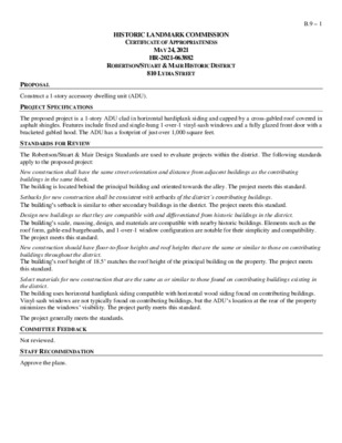
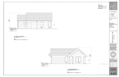
HISTORIC LANDMARK COMMISSION CERTIFICATE OF APPROPRIATENESS MAY 24, 2021 HR-2021-063882 ROBERTSON/STUART & MAIR HISTORIC DISTRICT 810 LYDIA STREET B.9 – 1 PROPOSAL Construct a 1-story accessory dwelling unit (ADU). PROJECT SPECIFICATIONS The proposed project is a 1-story ADU clad in horizontal hardiplank siding and capped by a cross-gabled roof covered in asphalt shingles. Features include fixed and single-hung 1-over-1 vinyl-sash windows and a fully glazed front door with a bracketed gabled hood. The ADU has a footprint of just over 1,000 square feet. STANDARDS FOR REVIEW The Robertson/Stuart & Mair Design Standards are used to evaluate projects within the district. The following standards apply to the proposed project: New construction shall have the same street orientation and distance from adjacent buildings as the contributing buildings in the same block. The building is located behind the principal building and oriented towards the alley. The project meets this standard. Setbacks for new construction shall be consistent with setbacks of the district’s contributing buildings. The building’s setback is similar to other secondary buildings in the district. The project meets this standard. Design new buildings so that they are compatible with and differentiated from historic buildings in the district. The building’s scale, massing, design, and materials are compatible with nearby historic buildings. Elements such as the roof form, gable-end bargeboards, and 1-over-1 window configuration are notable for their simplicity and compatibility. The project meets this standard. New construction should have floor-to-floor heights and roof heights that are the same or similar to those on contributing buildings throughout the district. The building’s roof height of 18.5’ matches the roof height of the principal building on the property. The project meets this standard. Select materials for new construction that are the same as or similar to those found on contributing buildings existing in the district. The building uses horizontal hardiplank siding compatible with horizontal wood siding found on contributing buildings. Vinyl-sash windows are not typically found on contributing buildings, but the ADU’s location at the rear of the property minimizes the windows’ visibility. The project partly meets this standard. The project generally meets the standards. COMMITTEE FEEDBACK Not reviewed. STAFF RECOMMENDATION Approve the plans. LOCATION MAP B.9 – 2 PROPERTY INFORMATION Photos B.9 – 3 Primary house at 810 Lydia Street. Source: Google Street View, 2019.
Nathaniel Bennett -�. General Contractor 11 00 Blackjack TX 78664 Lockhart, Phone: Bill To: Pat Calhoun 2401 Givens Ave Austin Tx DATE: INVOICE# FOR: May 20, 2021 1553 DESCRIPTION AMOUNT power wash house , caulk where brick is missing repair front fence and replace gate that couldn't be repaired -paint replace siding on rear addition with hardi-board paint siding, doors, garage.all trim. Stain wood vertical panels replace rotting boards of roof eaves -� out AC/Heating unit in rear addition- added 30+ years ago replace gutters-Givens side, caulk gutters Maple side 7 new windows - 2 entry doors 3,300.00 3,300.00 3,800.00 1,800.00 1,700.00 2,300.00 10,450.00 replace electrical panel -new wiring from aluminum, replace outlet burned electrical 6,695.00 replace bathroom fixture due to burned ballast that couldn't be replaced, replace burned reseal exterior and interior planter( removal of soil and plants, refill with soil and plants 2,910.00 1 TOT AL $ 36,255.00 Make all checks payable concerning If you have any questions to: Nathaniel contact: this invoice, Bennett Nathaniel Bennett, THANK YOU FOR YOUR BUSINESS!
Business Committee Meeting of the HIV Planning Council Monday, May 24, 2021 The Business Committee Meeting to be held 05/24/2021 with Social Distancing Modifications Public comment will be allowed via Microsoft Teams; no in-person input will be allowed. All speakers must register in advance (05/23/2021 by Noon). All public comment will occur at the beginning of the meeting. To speak remotely at the May 24, 2021 HIV Planning Council Meeting, residents must: •Call or email the board liaison at (512) 972-5806 and Jaseudia.Killion@austintexas.gov no later than noon, (the day before the meeting). The information required is the speaker name, item number(s) they wish to speak on, whether they are for/against/neutral, and a telephone number or email address. •Once a request to speak has been called in or emailed to the board liaison, residents will receive either an email or phone call providing the telephone number to call on the day of the scheduled meeting. •Speakers must call in at least 15 minutes prior to meeting start in order to speak, late callers will not be accepted and will not be able to speak. •Speakers will be placed in a queue until their time to speak. •Handouts or other information may be emailed to Jaseudia.Killion@austintexas.gov by Noon the day before the scheduled meeting. This information will be provided to Board and Commission members in advance of the meeting. •If this meeting is broadcast live, residents may watch the meeting here: http://www.austintexas.gov/page/watch- atxn-live Versión en español a continuación. Reunión del Special Called Buisness Committee Meeting of the HIV Planning Council la folletos junta en FECHA de la reunion (Monday, Mayo 24, 2021) La junta se llevará con modificaciones de distanciamiento social Se permitirán comentarios públicos por teléfono; no se permitirá ninguna entrada en persona. Todos los oradores deben registrarse con anticipación (05/23/2021 antes del mediodía). Todos los comentarios públicos se producirán al comienzo de la reunión. Para hablar de forma remota en la reunión, los miembros del público deben: • Llame o envíe un correo electrónico al enlace de (512) 972-5806 and Jaseudia.Killion@austintexas.gov a más tardar al mediodía (el día antes de la reunión). La información requerida es el nombre del orador, los números de artículo sobre los que desean hablar, si están a favor / en contra / neutrales, y un número de teléfono o dirección de correo electrónico. • Una vez que se haya llamado o enviado por correo electrónico …
Versión en español a continuación. Human Rights Commission Meeting May 24, 2021 Human Rights Commission to be held May 24, 2021 with Social Distancing Modifications Public comment will be allowed via telephone; no in-person input will be allowed. All speakers must register in advance (May 23, 2021 by noon). All public comment will occur at the beginning of the meeting. To speak remotely at the May 24, 2021 Human Rights Commission Meeting, members of the public must: •Call or email the board liaison Jonathan Babiak at (512) 974-3203 or jonathan.babiak@austintexas.gov no later than noon, May 23, 2021 (the day before the meeting). The following information is required: speaker name, item number(s) they wish to speak on, whether they are for/against/neutral, email address and telephone number (must be the same number that will be used to call into the meeting). •Once a request to speak has been made to the board liaison, the information to call on the day of the scheduled meeting will be provided either by email or phone call. •Speakers must call in at least 15 minutes prior to meeting start time in order to speak, late callers will not be accepted and will not be able to speak. •Speakers will be placed in a queue until their time to speak. •Handouts or other information may be emailed to jonathan.babiak@austintexas.gov by noon the day before the scheduled meeting. This information will be provided to Board and Commission members in advance of the meeting. •If the meeting is broadcast live, it may be viewed here: http://www.austintexas.gov/page/watch-atxn-live Reunión del HUMAN RIGHTS COMMISSION FECHA de la reunion May 24, 2021 La junta se llevará con modificaciones de distanciamiento social Se permitirán comentarios públicos por teléfono; no se permitirá ninguna entrada en persona. Todos los oradores deben registrarse con anticipación (May 23, 2021 antes del mediodía). Todos los comentarios públicos se producirán al comienzo de la reunión. Para hablar de forma remota en la reunión, los miembros del público deben: • Llame o envíe un correo electrónico al enlace de la junta en Jonathan Babiak at (512) 974-3203 or jonathan.babiak@austintexas.gov a más tardar al mediodía (el día antes de la reunión). Se requiere la siguiente información: nombre del orador, número (s) de artículo sobre el que desean hablar, si están a favor / en contra / neutral, dirección de correo electrónico (opcional) y un número de teléfono (debe ser el número que …
MUNICIPAL CIVIL SERVICE COMMISSION MEETING MINUTES Thursday, May 20, 2021 SPECIAL CALLED MEETING Thursday, May 20, 2021 MUNICIPAL CIVIL SERVICE COMMISSION MINUTES The Municipal Civil Service Commission convened in a special called meeting on Thursday, May 20, 2021 via videoconferencing. Chair Peréz-Wiseley called the Commission meeting to order at 10:07 a.m. Commissioners in Attendance: Teresa Peréz-Wiseley, Chair Kevin Mullin McKenzie Frazier Andy Mormon Commissioners Absent: Melissa Rogers, Vice-Chair Staff in Attendance: Matthew Chustz, Municipal Civil Service Administrator April Shaw, Municipal Civil Service Coordinator Michael Sullivan, Civil Service Coordinator 1. STAFF BRIEFING Department. a. Staff presentation regarding Commissioner orientation from the Human Resources Matthew Chustz, Municipal Civil Service Administrator, provided an orientation to the Municipal Civil Service Commission. 2. FUTURE AGENDA ITEMS None. ADJOURNMENT Chair Peréz-Wiseley adjourned the meeting at 12:23 p.m. without objection. 1
Versión en español a continuación. Historic Landmark Commission Meeting Monday, May 24th, 2021, 6:00 PM Historic Landmark Meeting to be held May 24th, 2021 with Social Distancing Modifications Public comment will be allowed via telephone; no in-person input will be allowed. All speakers must register in advance (Sunday, May 23rd by noon). All public comment will occur at the beginning of the meeting. To speak remotely at the May 24th Historic Landmark Commission Meeting, members of the public must: Call or email the board liaison at (512) 974-3393 or preservation@austintexas.gov no later than noon, Sunday, May 23 (the day before the meeting). The following information is required: speaker name, item number(s) they wish to speak on, whether they are for/against/neutral, email address and telephone number (must be the same number that will be used to call into the meeting). Once a request to speak has been made to the board liaison, the information to call on the day of the scheduled meeting will be provided either by email or phone call. Speakers must call in at least 15 minutes prior to meeting start time in order to speak, late callers will not be accepted and will not be able to speak. Speakers will be placed in a queue until their time to speak. Handouts or other information may be emailed to preservation@austintexas.gov by noon the day before the scheduled meeting. This information will be provided to Board and Commission members in advance of the meeting. If the meeting is broadcast live, it may be viewed here: http://www.austintexas.gov/page/watch-atxn-live Reunión del Historic Landmark Commission FECHA de la reunion (24 de mayo, 2021) La junta se llevará con modificaciones de distanciamiento social Se permitirán comentarios públicos por teléfono; no se permitirá ninguna entrada en persona. Todos los oradores deben registrarse con anticipación (23 de mayo, 2021 antes del mediodía). Todos los comentarios públicos se producirán al comienzo de la reunión. Para hablar de forma remota en la reunión, los miembros del público deben: Llame o envíe un correo electrónico al enlace de la junta en (512) 974-3393 or preservation@austintexas.gov a más tardar al mediodía (el día antes de la reunión). Se requiere la siguiente información: nombre del orador, número (s) de artículo sobre el que desean hablar, si están a favor / en contra / neutral, dirección de correo electrónico (opcional) y un número de teléfono …
1304 Bob Harrison - 3D Massing Fox Fox Studio ---- May 7th, 2021 East Facade Street Facade Fox Fox Studio ---- May 7th, 2021 New Addition: Vertical Metal Siding Historic House: Existing Vertical Board and Batten West Facade Street/ West Facade Fox Fox Studio ---- May 7th, 2021 East Facade (new addition) North Facade (new addition) Fox Fox Studio ---- May 7th, 2021 Remove Skylight on front roof Rebuild porch to existing specs Existing Vertical Board and Batten View 1: Street Facade Windows replaced with period wood clad Removed glass door and sidelight Fox Fox Studio ---- May 7th, 2021 View 2: Fox Fox Studio ---- May 7th, 2021 View 3: Fox Fox Studio ---- May 7th, 2021
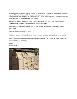
Steve: Detailed moving instructions. Hector Masonary is doing the work they did the complete tear down and repoint of the main house in 1998. Very competent team of brothers. 1. Shed needs to be re‐mortared the existing shed has a cast in place ceiling that is dangerous and many large cracks exist on interior and exterior of building. 2. Number each Block and remove one at a time with scaffolds as to not crack or damage historic rusticated blocks of cream cordovia limestone. ( tan / cream color) 3. Pour new slab with #4 and #5 rebar with 12" wide footings around entire parameter to bedrock 2' below grade; 4. Pour 6" slab for interior w/ #5 rebar ; 5. Measure sand grain diameter for white masonry cement mixture set stones with 1" mortar joints ; 6. Use existing tin from roof and replace cedar rafters as needed; Cost is $8500.00 2 week process See pics and drawing on next email Regards, Jim Stockbauer
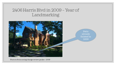
2406 Harris Blvd in 2009 – Year of Landmarking Patio already Existed in 2009 Photo is from zoning change review packet - 2009 Current and Future Views – The Same But Better What we have…. • Substandard landscaping • Safety issues – high traffic area • No use of >50% of property • Immediate neighbors say “eyesore” What we will have: Improved safety • • Use of front yard - >50% of property • Life in front of house • No pool parties – 14’ x 28’ only; 5’ deep • Transparent fencing – no blocking of façade. Proposed Pool – Flush with Grade – Not Visible from Street Fence at perimeter would be minimally visible and follow the pattern of neighbor’s house. Site Plan with Pool – Offset from Front Façade • No raised edge in current design • Not visible from street • 14 feet x 28 feet • Does not touch historic structure • Will not be a party pool • No pink flamingos • No yellow umbrellas • Looks better than a boat trailer Fence Design Options (Height not to Exceed 6’ from Grade) Water Feature 1706 Niles Road Fred and Margaret Sharp House • Open design; • Visual weight provided by columns; • Approved by HLC in 2012 Texas Governor’s Mansion • Open design; • Undeniably historically appropriate
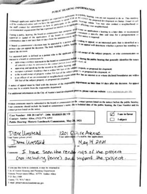
PUBL IC HEARINC INFORMATION (cid:10) Akthough will be conducted online and you have the applicants and/or their agent(s) are (cid:10) to spe (cid:10) in the publ (cid:10) the staff (cid:10) eIN contact for infor on how (cid:10) orgniration has expre (cid:10) tO pa (cid:10) sscd an (cid:10) rticipate (cid:10) interesd (cid:10) orD (cid:10) the board or may posipc (cid:10)ssion (cid:10) During a public (cid:10) approval or denial of the application (cid:10) continuation that is not later than 60 (cid:10) If the board (cid:10) the annOu (cid:10) A board (cid:10) person who can appeal the decision (cid:10) appcal the decision (cid:10) The body (cid:10) Aing ap (cid:10) An interested party is defined as a person who is the applicant of (cid:10) rticipate (cid:10) in a public hcan (cid:10) FOR or AGAINST ic 1 (cid:10) the (cid:10) you are not required to do so mesting (cid:10) proposed development or change Fmeil or oall (cid:10) in an app (cid:10) aiiciton neighborhood (cid:10) Marings online You may also contact a neighborhood Or (cid:10) ton's hearing to a later date, or recomnmend (cid:10) a specific date and time for a postpone (cid:10) required (cid:10) by a personi (cid:10) ith rtanding t appeal (cid:10) of an dctemine is identified as a (cid:10) atanding to (cid:10) a peron ond owner of the property, or who (cid:10) board or (cid:10) deliveriny to the board or commission (cid:10) ot during the public hcaring (cid:10) and speakine for the record at the publi (cid:10) poperty or developme (cid:10) eccupees a prmary is the is an offhcor off am cm thetis within (cid:10) of proporty $00 foct of the propcry or proposcod (cid:10) wo feet of the (cid:10) foct of the srhood orgam (cid:10) of appcal otth the directof (cid:10) form may be an ailable from the rospomibic (cid:10) sation that han development, in or whose declared boundaries are within (cid:10) o (cid:10) departmen no later than 14 days ater the decision An appe (cid:10) imformation Amtin's land (cid:10) visil Our (cid:10) Wrinon oommonts must te (cid:10) Your porsomn listod on (cid:10) board of Oommisaon's (cid:10) Case Numbof (cid:10) HR 20-144747. 2406 HARRIS BL VD (cid:10) Comtact: Ambor Allon, (512) 974-3393 (cid:10) Pablic Hearing (cid:10) Historic Landmark Oommission (cid:10) totice) &cforg the public hcaring (cid:10) the Cave Nomber and the (cid:10) Your (cid:10) 1 22l (cid:10) Commonts (cid:10) I hae nd (cid:10) f (cid:10) of Austin Housang and Planoung (cid:10) it …
* * * E x t e r n a l E m a i l - E x e r c i s e C a u t i o n * * * T o F o m D a t e S u b j e c t l A Z e s e v a t i o n H R 2 1 - 0 6 3 8 3 0 & G 2 1 - 0 6 7 0 2 0 d a y M a y 2 1 2 0 2 1 1 1 2 1 0 6 A M C A U T I O N T h i s e m a i l w a s r e c e i e d a t t h e C i y o f A u s t i n f r o m a n E X T E R N A L s o u r c e . P l e a s e u s e c a u t o n w h e n c l i c k i n g l i n k s o r o p e n i n g a t t a c h m e n t s . I f y o u b e l i e e t h i s t o b e a m a l i c i o u s a n d / o r p h i s h i n g e m a i l p l e a s e f o r w a r d t h s e m a i l t o c y b e r s e c u r i t y @ a u s t i n t e x a s . g o .
2308 Woodlawn Blvd. 2021-066900 HR 2021-072218 PR Historic Landmark Commission May 24, 2021 1 SITE 2 SITE 3 SITE COA Historic Landmarks National Register of Historic Places 4 Facts • House was built in 1940. • Current owners purchased in August of 2020. • House was being renovated internally and almost complete when fire took place. • Current owners were two weeks away from moving in. 5 6 7 8 9 10 Request We respectfully request your support for full demolition permit and to help put this family back in their home as soon as possible. 11 Next Steps • Submit New Construction Permit application. • Receive new plans approval from HLC within ~3 months. 12 13
From: To: Subject: Date: Attachments: Gregory W. Smith Sadowsky, Steve RE: J.J. Hegman House, 4714 Rowena Street, Austin Wednesday, April 14, 2021 10:27:24 AM image001.png thc_email_logo_65px_e6b590e5-b608-48df-a46f-bbaf70308c09.png thc_email_signature_url_2_9467b7d4-3cf0-4ad6-a56a-a173b9a5102c.png thc_email_signature_fb_18px_f52434f2-a1bc-4678-9a22-33dd4606f18b.png thc_email_signature_twitter_18px_a0320705-84ac-453d-b948-ce7b9ec24d9b.png thc_email_signature_ig_18px_b246144c-2e4c-4e72-a377-d3dbb77f8934.png thc_email_signature_yt_18px_87f9dc8d-8149-47b9-988d-88c487090614.png thc_email_signature_li_18px_5bdd2c5b-c609-480e-a872-4fe1572cd908.png thc_email_signature_email_18px_61592cdc-f8f6-43c2-83c5-648830375491.png *** External Email - Exercise Caution *** Hello Steve I’m still racking my brain over this. There’s so much circumstantial evidence that I wish added up to a clear narrative supporting individual significance. The house is cool and unusual, but I’m struggling to come up with a clear argument that would convince the NPS staff of its individual significance. The archival record is incomplete and hard to reconcile with what we see today. I’m confident that the core house dates to the first decade of the 20th century at the latest. It was modified at some point with the application of stucco and the pop-up roof, and I don’t think these changes would prevent it from contributing to a district. The association with Hegman is sketchy, and even if it could be proven to have been his residence at some point, he lived in other houses as well. Is the house is significant under Criterion B for association with Hegman as a theater owner? The theaters themselves (the Ritz in particular) better represent this aspect of his productive life. Is it significant for its association with Hegman as the developer of a subdivision? I would think the house at 108 E. 48th Street, where he also lived at some point, seems like a better fit. I don’t understand why he would leave the 2-story brick house on a large lot in the heart of his subdivision for a older house immediately to the west. It doesn’t add up. I think the best shot would be Criterion C in the area of architecture, as a modified turn-of-the-century house (I’ll call it Queen Anne Cottage). The key to this argument would be to detail when and by whom the changes were made, AND argue that these changes themselves are architecturally significant. This case would be more easily made if the alterations were of a type that reflected changes in popular taste - we’ve done this in nominations where a house is substantially updated to reflect an entirely new style (often Beaux Arts after the Columbian expo, or an old plantation style perhaps popularized by Gone With the Wind). That’s not the case here, and we can only guess at …
1304 Bob Harrison - HLC Design Revisions Fox Fox Studio ---- May 24th, 2021 East Facade Street Facade Fox Fox Studio ---- May 24th, 2021 New Addition: Vertical Metal Siding Historic House: Existing Vertical Board and Batten West Facade Street/ West Facade Fox Fox Studio ---- May 24th, 2021 East Facade (new addition) North Facade (new addition) Fox Fox Studio ---- May 24th, 2021 Precedent Roof and Window Examples in Neighborhood 1211 E 13th Street 1405 Bob Harrison Street 1208 Bob Harrison Street (2 over 2 window 1707 Newton Street (roof type preference) 1172 1/2 San Bernard Street 1208 Bob Harrison Street Fox Fox Studio ---- May 24th, 2021 Remove Skylight on front roof Rebuild porch to existing specs Existing Vertical Board and Batten Color: Farrow & Ball, School House White No. 291 View 1: Street Facade Windows replaced with period Removed glass door and sidelight 2 over 2 window Fox Fox Studio ---- May 24th, 2021 View 2: Windows replaced with period 2 over 2 window Fox Fox Studio ---- May 24th, 2021 Existing underside of roof - no original cedar shingle View 3: Fox Fox Studio ---- May 24th, 2021
911-09-07 Congress Avenue Grandberry Building and Mitchell-Robertson Building, 911 Congress Avenue Historic District Congress Avenue Historic District May 24, 2021 Intro • Fall 2020: Complaints made to Building and Standards Commission (BSC) • March 24, 2021: BSC ordered Landowner to finalize all necessary permits with HLC by June 22, 2021 • March-April 2021 Meetings: Applicant team provided evidence that keeping building facades in place is not feasible • May 2021 Meeting: Applicant team brings • corroboration based on extensive and ongoing investigation June 2021 Meeting: Applicant team to bring Demolition Permit with finalized deconstruction and reconstruction plan 2 BSC Order Requires All Permits, including HLC, by June 22, 2021 3 Updates • • • • • Initial onsite investigation and conditional assessment of the buildings Safety Plan for Work, Neighbors and Public Contacted Austin History Center to locate any additional photos or documentation of the properties Initial scans of the building interior and exterior (Missing final scans of front facades and roof) Preliminary digital 3D model within Revit is underway 4 Updates • Received a 1985 memo of 907 written by Bell, Klein and Hoffman from Austin History Center which states, “[the brick] appears to be fire damaged in areas. After that was stuccoed and scored.” 1978 IMAGE 5 Updates • • • At some point in the late 70s 911 was covered in stucco. Facades have been hidden for a long time. • Modifications have done damage to the original fabric. All ornamentation is missing and would need to be replaced with new based on historic photographs. 1982 DWG 1978 IMAGE 6 911 - Visual Assessment • • Brick has been scored and stucco adhered directly. All ornamentation of the window headers, cornice, and brick sills were removed in the late 70s to early 80s for the addition of stucco. • Most of the original façade • has been lost. Stucco has severe deterioration. 7 909 - Visual Assessment • • Storefront is missing. Steel header is not adequate due to rust and deflection. • Noticeable cracks in the front • • façade. Structural columns are modern and not original. Existing (potentially original) brick below steel header has deteriorated and collapsed. • Upper portion of the building is in the best condition of the three structures. 8 907 - Visual Assessment • Most original features are • • missing. Stone, brick, and mortar are in poor condition with evidence …
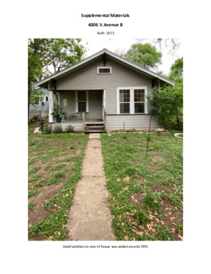
Supplemental Materials 4006 ½ Avenue B Built: 1923 Small addition to rear of house was added around 1991 Proposed addition Non-original aluminum frame windows to be replaced with new windows more closely resembling originals. Addition will match original lap siding. 4413 Avenue C Built: 1927 Second floor added in 2011 4113 Avenue D Built: 1932 Second floor added in 2019 4303 Speedway Built: 1920 Added second floor in 2010 4103 Avenue A Built: 1924 Second floor added in 2003 3913 Avenue F Built: 1906 Second floor added in 2008 4207 Avenue H Built: 1925 Second floor added in 2017