ZONING CHANGE REVIEW SHEET CASE: C14-94-0167.01 (6500 River Place PDA Amendment #1) DISTRICT: 10 ADDRESS: 6500 River Place Boulevard ZONING FROM: R&D-PDA TO: R&D-PDA* *The applicant is requesting an amendment to the existing PDA overlay conditions to permit Multifamily Residential and Outdoor Sports and Recreation uses on the property. SITE AREA: 47.992 acres PROPERTY OWNER: G&I VII River Place, LP APPLICANT/AGENT: Drenner Group, PC (David J. Anderson) CASE MANAGER: Sherri Sirwaitis (512-974-3057, sherri.sirwaitis@austintexas.gov) STAFF RECOMMEDATION: Staff recommends R&D-PDA, Research and Development-Planned Development Area Combining District, zoning to change a condition of zoning to permit Multifamily Residential and Outdoor Sports and Recreation uses to the PDA overlay. ZONING AND PLATTING COMMISSION ACTION / RECOMMENDATION: May 20, 2025: Postponed to June 3, 2025 at the staff's request by consent (9-0); Lugo-1st, Greenberg-2nd. June 3, 2025: Postponed to July 1, 2025 at the neighborhood's request by consent (9-0, C. Tschoepe-arrived late, F. De Portu-absent); L. Stern-1st, A. Flores-2nd. July 1, 2025 CITY COUNCIL ACTION: ORDINANCE NUMBER: 02 C14-94-0167.01 - 6500 River Place PDA Amendment #1; District 101 of 54 ISSUES: N/A CASE MANAGER COMMENTS: The site under consideration is a 48-acre tract of land located near the southwest intersection of FM 2222 Road and River Place Boulevard. The property was zoned R&D-PDA in 1995 through Ordinance No. 950427-R and is developed with an office park (River Place Corporate Park) that contains seven buildings, with surface parking. There is undeveloped land zoned GR-CO directly to the north. To the south, there are office and single family residential uses that are zoned GO-CO and SF-5. The lots to the east are developed with an automotive repair use, a commercial retail center, a restaurant, financial services and medical office uses. To the west there is undeveloped land in the county. The applicant is requesting a rezoning of the property to amend the existing PDA overlay to permit Multifamily Residential and Outdoor Sports and Recreation uses on the property. The applicant plans to replace two of the existing office buildings on the site by constructing two new multifamily complexes, with publicly accessible outdoor recreation amenities (please see Applicant’s Request Letter – Exhibit C). BASIS OF RECOMMENDATION: 1. The proposed zoning should be consistent with the purpose statement of the district sought. Research and development district is the designation for a research use located on a site with a campus-style design. An R&D district designation may be applied …
ZONING CHANGE REVIEW SHEET CASE: C14-2025-0032 (Acres West Lot 20 Rezone) DISTRICT: 6 ADDRESS: 13608 Caldwell Drive ZONING FROM: I-RR TO: SF-6 SITE AREA: 0.407 acres PROPERTY OWNER: Austintatious Enterprises, LLC (David Jeng) APPLICANT/AGENT: Central Texas Permit Partners (Tisha Ritta) CASE MANAGER: Sherri Sirwaitis (512-974-3057, sherri.sirwaitis@austintexas.gov) STAFF RECOMMEDATION: Staff recommends SF-6, Townhouse and Condominium Residence District, zoning. ZONING AND PLATTING COMMISSION ACTION / RECOMMENDATION: July 1, 2025 CITY COUNCIL ACTION: ORDINANCE NUMBER: 03 C14-2025-0032 - Acres West Lot 20 Rezone; District 61 of 29 C14-2025-0032 ISSUES: N/A CASE MANAGER COMMENTS: 2 The property in question is a 0.407 acre undeveloped lot that fronts onto Caldwell Drive. There are professional office and medical office uses to the north and east zoned GO-CO. The lots to the south are developed with single-family residences zoned SF-2. To the west there is an undeveloped area, a detention pond and a residential condominium development with GO-CO zoning and an I-RR designation. In this case, the applicant is requesting to establish permanent SF-6 zoning to allow for a single-family and condominium development on this property (please see the Applicant’s Summary Letter – Exhibit C). The staff recommends the applicant’s request for Townhouse and Condominium Residence district zoning. The proposed zoning is consistent with the purpose statement as the property is located on a residential collector roadway. The proposed zoning will provide a transition from the office zoning/uses to the north and east to the single-family residences along Caldwell Lane to the south. SF-6 zoning will permit the development of additional residential uses in this area and it will establish a permanent zoning designation on this currently undeveloped lot. BASIS OF RECOMMENDATION: 1. The proposed zoning should be consistent with the purpose statement of the district sought. Townhouse and Condominium Residence district is intended as an area for moderate density single family, duplex, two family, townhouse, and condominium use, without the spacing and locational requirements for townhouses and condominiums that apply in SF-5. This district is appropriate for areas in which unusually large lots predominate with access to other than minor residential streets, and in selected areas where a transition from single-family to multifamily use is appropriate. 2. The proposed zoning should promote consistency and orderly planning. The proposed zoning will provide a transition from the GO-CO zoning/office uses to the north and east to the SF-2 zoning/single-family residences along Caldwell Lane to the south. It is …
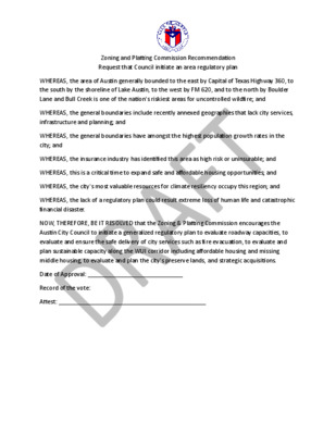
Zoning and Platting Commission Recommendation Request that Council initiate an area regulatory plan WHEREAS, the area of Austin generally bounded to the east by Capital of Texas Highway 360, to the south by the shoreline of Lake Austin, to the west by FM 620, and to the north by Boulder Lane and Bull Creek is one of the nation's riskiest areas for uncontrolled wildfire; and WHEREAS, the general boundaries include recently annexed geographies that lack city services, infrastructure and planning; and WHEREAS, the general boundaries have amongst the highest population growth rates in the city; and WHEREAS, the insurance industry has identified this area as high risk or uninsurable; and WHEREAS, this is a critical time to expand safe and affordable housing opportunities; and WHEREAS, the city's most valuable resources for climate resiliency occupy this region; and WHEREAS, the lack of a regulatory plan could result extreme loss of human life and catastrophic financial disaster. NOW, THEREFORE, BE IT RESOLVED that the Zoning & Platting Commission encourages the Austin City Council to initiate a generalized regulatory plan to evaluate roadway capacities, to evaluate and ensure the safe delivery of city services such as fire evacuation, to evaluate and plan sustainable capacity along the WUI corridor including affordable housing and missing middle housing, to evaluate and plan the city's preserve lands, and strategic acquisitions. Date of Approval: _____________________________ Record of the vote: Attest: _____________________________________________
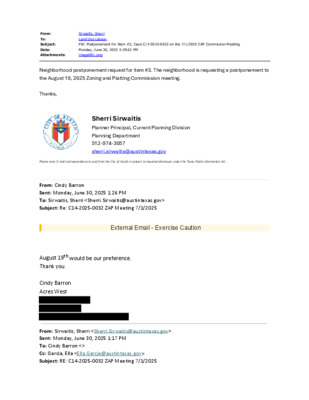
From: To: Subject: Date: Attachments: Sirwaitis, Sherri Land Use Liaison FW: Postponement for Item #3, Case C14-2025-0032 on the 7/1/2025 ZAP Commission Meeting Monday, June 30, 2025 4:29:52 PM image001.png Neighborhood postponement request for item #3. The neighborhood is requesting a postponement to the August 19, 2025 Zoning and Platting Commission meeting. Thanks, Sherri Sirwaitis Planner Principal, Current Planning Division Planning Department 512-974-3057 sherri.sirwaitis@austintexas.gov Please note: E-mail correspondence to and from the City of Austin is subject to required disclosure under the Texas Public Information Act. From: Cindy Barron Sent: Monday, June 30, 2025 1:26 PM To: Sirwaitis, Sherri <Sherri.Sirwaitis@austintexas.gov> Subject: Re: C14-2025-0032 ZAP Meeting 7/1/2025 External Email - Exercise Caution August 19th would be our preference. Thank you. Cindy Barron Acres West From: Sirwaitis, Sherri <Sherri.Sirwaitis@austintexas.gov> Sent: Monday, June 30, 2025 1:17 PM To: Cindy Barron <> Cc: Garcia, Ella <Ella.Garcia@austintexas.gov> Subject: RE: C14-2025-0032 ZAP Meeting 7/1/2025 Hi Cindy, Please state the specific date for your postponement request. The next available Zoning and Platting Commission meeting dates are July 15, 2025 and August 19, 2025. I am not scheduling cases for the August 5, 2025 meeting date because I will be of the office that week. Thank you, Sherri Sirwaitis Planner Principal, Current Planning Division Planning Department 512-974-3057 sherri.sirwaitis@austintexas.gov Please note: E-mail correspondence to and from the City of Austin is subject to required disclosure under the Texas Public Information Act. From: Cindy Barron < > Sent: Monday, June 30, 2025 1:08 PM To: Sirwaitis, Sherri <Sherri.Sirwaitis@austintexas.gov> Cc: Garcia, Ella <Ella.Garcia@austintexas.gov> Subject: C14-2025-0032 ZAP Meeting 7/1/2025 External Email - Exercise Caution The neighborhood of Acres West would like to request a postponement of the ZAP public hearing for Case #C14-2025-0032 scheduled for July 1, 2025. We have made attempts to formalize a meeting with the applicant but have not been successful. We would hope an approved 4-week postponement might give us the time both parties may need to meet and go over project plans and concerns. Thank you for your consideration to this request. Cindy Barron CAUTION: This is an EXTERNAL email. Please use caution when clicking links or opening attachments. If you believe this to be a malicious or phishing email, please report it using the "Report Message" button in Outlook. For any additional questions or concerns, contact CSIRT at "cybersecurity@austintexas.gov". CAUTION: This is an EXTERNAL email. Please use caution when clicking links or opening attachments. If you …
ZONING AND PLATTING COMMISION REGULAR CALLED MEETING TUESDAY, JULY 1, 2025 The Zoning and Platting convened in a regular meeting on Tuesday, July 1, 2025, at Austin City Hall, Boards and Commissions, Room 1101, 301 W. Second Street, in Austin, Texas. Chair Smith called the Zoning and Platting Meeting to order at 6:00 p.m. Commissioners in Attendance: Hank Smith Betsy Greenberg Luis Osta Lugo Christian Tschoepe Commissioners in Attendance Remotely: Scott Boone David Fouts Ryan Puzycki Commissioners Absent: Alejandra Flores Taylor Major Lonny Stern 1 vacancy on the dais. PUBLIC COMMUNICATION: GENERAL None. APPROVAL OF MINUTES 1. Approve the minutes of the Zoning and Platting Commission regular meeting on Tuesday, June 17, 2025. 1 The minutes from the meeting of Tuesday, June 17, 2025, were approved on the consent agenda on Vice Chair Greenberg’s motion, Commissioner Tschoepe’s second, on a 7-0 vote. Commissioners Flores, Major, and Stern were absent. PUBLIC HEARINGS 2. Rezoning: Location: Owner/Applicant: Agent: Request: Staff Rec.: Staff: C14-94-0167.01 - 6500 River Place PDA Amendment #1; District 10 6500 River Place Boulevard, Panther Hollow, Lake Travis Watersheds G&I VII River Place, LP Drenner Group, PC (David J. Anderson) R&D-PDA to R&D-PDA, to change a condition of zoning Recommended Sherri Sirwaitis, 512-974-3057, sherri.sirwaitis@austintexas.gov Planning Department The motion to approve Staff’s recommendation of R&D-PDA, to change a condition of zoning, for C14-94-0167.01 - 6500 River Place PDA Amendment #1; District 10, located at 6500 River Place Boulevard, was approved on the consent agenda on Vice Chair Greenberg’s motion, Commissioner Tschoepe’s second, on a 7-0 vote. Commissioners Flores, Major, and Stern were absent. C14-2025-0032 - Acres West Lot 20 Rezone; District 6 13608 Caldwell Drive, Lake Creek Watershed 3. Rezoning: Location: Owner/Applicant: Austintatious Enterprises, LLC Agent: Request: Staff Rec.: Staff: Central Texas Permit Partners (Tisha Ritta) I-RR to SF-6 Recommended Sherri Sirwaitis, 512-974-3057, sherri.sirwaitis@austintexas.gov Planning Department The motion to approve the Neighborhood’s Postponement request to August 19, 2025, was approved on the consent agenda on Vice Chair Greenberg’s motion, Commissioner Tschoepe’s second, on a 7-0 vote. Commissioners Flores, Major, and Stern were absent. DISCUSSION AND ACTION ITEMS 4. Discussion and action regarding the September 12, 2023, Planning Commission Recommendation to Council to establish a Regulatory Plan for the area generally bounded to the east by Capital of Texas Hwy 360, to the south by the north shoreline of Lake Austin, to the west by 620, and to the north by Boulder …
REGULAR MEETING of the ZONING AND PLATTING COMMISSION TUESDAY, JUNE 17, 2025, 6:00 PM AUSTIN CITY HALL, COUNCIL CHAMBERS, ROOM 1001 301 WEST 2ND STREET AUSTIN, TEXAS Some members of the Zoning and Platting Commission may be participating by videoconference. The meeting may be viewed online at: http://www.austintexas.gov/page/watch-atxn-live. Public comment will be allowed in-person or remotely via telephone. Speakers may only register to speak on an item once either in-person or remotely. Registration no later than 2 PM the day of the meeting is required for remote participation by telephone. For more information on public comment, please see the agenda section “Speaker Registration.” Please contact Ella Garcia, Staff Liaison, for questions regarding speaker registration at LandUseLiaison@austintexas.gov or by phone at 512-978-0821. CURRENT BOARD MEMBERS/COMMISSIONERS: Hank Smith – Chair (District 8) Betsy Greenberg – Vice-Chair (District 10) Ryan Puzycki – Secretary (District 7) Alejandra Flores – Parliamentarian (District 5) Luis Osta Lugo (Mayor’s Representative) Scott Boone (District 1) David Fouts (District 2) Lonny Stern (District 3) Vacant (District 4) Christian Tschoepe (District 6) Taylor Major (District 9) EXECUTIVE SESSION (No public discussion) The Zoning and Platting Commission will announce it will go into Executive Session, if necessary, pursuant to Chapter 551 of the Texas Government Code, to receive advice from Legal Counsel on matters specifically listed on this agenda. The commission may not conduct a closed meeting without the approval of the city attorney. Private Consultation with Attorney – Section 551.071 Staff Liaison: Ella Garcia, 512-978-0821 Attorney: Jenna Schwartz, 512-978-0871 Page 1 of 7 AGENDA CALL TO ORDER PUBLIC COMMUNICATION: GENERAL The first four speakers signed up prior to the meeting being called to order will each be allowed a three-minute allotment to address their concerns regarding items not posted on the agenda. APPROVAL OF MINUTES 1. Approve the minutes of the Zoning and Platting Commission regular meeting on June 3, 2025. PUBLIC HEARINGS 2. Rezoning: C14-2025-0050 - North Loop Community Commercial; District 7 2302 and 2304 West North Loop Boulevard, Shoal Creek Watershed Location: Owner/Applicant: Cuisines of Mexico Inc. Agent: Request: Staff Rec.: Staff: Thrower Design, LLC (Ron Thrower & Victoria Haase) LR to GR Recommended Cynthia Hadri, 512-974-7620, cynthia.hadri@austintexas.gov Planning Department C14-2025-0002 - Cooper Apartments; District 5 7804 Cooper Lane, South Boggy Creek Watershed 3. Rezoning: Location: Owner/Applicant: 7804 Cooper Lane LLC (Stephen Stokes) 7804 Cooper Lane LLC (Stephen Stokes) Agent: SF-3-CO to MF-3 Request: Recommendation of MF-2 Staff …
ZONING AND PLATTING COMMISION REGULAR CALLED MEETING TUESDAY, JUNE 3, 2025 The Zoning and Platting convened in a regular meeting on Tuesday, June 3, 2025, at Austin City Hall, Council Chambers, Room 1001, 301 W. Second Street, in Austin, Texas. Chair Smith called the Zoning and Platting Meeting to order at 6:01 p.m. Commissioners in Attendance: Hank Smith Betsy Greenberg Luis Osta Lugo Lonny Stern Commissioners in Attendance Remotely: Scott Boone Alejandra Flores David Fouts Taylor Major Ryan Puzycki Christian Tschoepe Commissioners Absent: Felix De Portu PUBLIC COMMUNICATION: GENERAL Jennifer Mushtaler – Consideration of the September 12, 2023, Planning Commission recommendation. APPROVAL OF MINUTES 1. Approve the minutes of the Zoning and Platting Commission regular meeting on Tuesday, May 20, 2025. 1 The minutes from the meeting of May 20, 2025, were approved on the consent agenda on Commissioner Stern’s motion, Commissioner Flores’ second on a 10-0 vote. Commissioner De Portu was absent. PUBLIC HEARINGS 2. Rezoning: Location: C14-2024-0159 - Research Park PDA Amendment; District 6 12219 ½, 12455, 12487 ½, 12489, 12489 ½, 12491 ½, 12501, 12515 ½, 12517 ½ Research Boulevard Service Road Southbound, 12220 ½ Riata Trace Parkway, 6511 ½ and 6513 McNeil Road, Walnut Creek and Rattan Creek Watersheds Owner/Applicant: Karlin Research Park Development, LLC, Karlin Research Park, LLC Agent: Request: Staff Rec.: Staff: (Matthew Schwab) Armbrust & Brown, PLLC (Richard T. Suttle) LI-PDA to LI-PDA, to change a condition of zoning Recommended, with conditions Sherri Sirwaitis, 512-974-3057, sherri.sirwaitis@austintexas.gov Planning Department The motion to approve Staff’s recommendation of LI-PDA, with conditions, to change a condition of zoning, for C14-2024-0159 - Research Park PDA Amendment; District 6, located at 12219 ½, 12455, 12487 ½, 12489, 12489 ½, 12491 ½, 12501, 12515 ½, 12517 ½ Research Boulevard Service Road Southbound, 12220 ½ Riata Trace Parkway, 6511 ½ and 6513 McNeil Road, was approved on the consent agenda on Commissioner Stern’s motion, Commissioner Flores’ second, on a 10-0 vote. Commissioner De Portu was absent. 2 3. Rezoning: Location: C14-2024-0170 - Duval PDA; District 6 5501 Duval Road; 11705, 11755, 11755 ½, 11757 ½, 11781 ½, 11785 ½, 11801 ½, Research Boulevard SVRD NB, 11900, 11900 ½, 11902 ½, 11904 ½ West Cow Path, Walnut Creek Watershed Owner/Applicant: Karlin Duval, LLC (Matthew Schwab) Agent: Request: Staff Rec.: Staff: Armbrust & Brown, PLLC (Richard T. Suttle) LI, LI-CO and LO to LI-PDA Recommended, with conditions Sherri Sirwaitis, 512-974-3057, sherri.sirwaitis@austintexas.gov Planning Department …
ZONING CHANGE REVIEW SHEET CASE: C14-2025-0050 North Loop Community Commercial DISTRICT: 7 ZONING FROM: LR ADDRESS: 2302 and 2304 West North Loop Boulevard PROPERTY OWNER: Cuisines of Mexico, Inc. ZONING TO: GR SITE AREA: 0.64 acres (27, 878 sq. ft.) AGENT: Thrower Design, LLC (Ron Thrower & Victoria Haase) CASE MANAGER: Cynthia Hadri 512-974-7620, Cynthia.hadri@austintexas.gov STAFF RECOMMENDATION: The staff recommendation is to grant community commercial (GR) district zoning. ZONING AND PLATTING COMMISSION ACTION / RECOMMENDATION: June 17, 2025: CITY COUNCIL ACTION: ORDINANCE NUMBER: ISSUES: N/A CASE MANAGER COMMENTS: The property in question is approximately 0.64 acres, developed with one building and a parking lot. There is direct access to West North Loop Boulevard (level 3) which has sidewalks and bike lanes. The site is currently zoned neighborhood commercial (LR) district and previously had a laundry service use. The street is characterized as mixed use with a variety of commercial uses and multifamily buildings. The property has multifamily residential uses (MF-4; CS-V; GR) to the north, south and east as well as single family residential (SF-2) to the northwest. There are various commercial uses such as restaurants, service station and offices (GR and LR) to the south, east and west. Please refer to Exhibits A (Zoning Map) and B (Aerial View). Staff is recommending the community commercial (GR) district zoning for the proposed outdoor seating area that is approximately 2, 450 square feet for the restaurant. There is no 02 C14-2025-0050 - North Loop Community Commercial; District 71 of 10 demolition proposed for the future use of the structure. Please refer to Exhibit C (Applicant’s Summary Letter). Per the comprehensive plan review comments this site meets eight of the Imagine Austin Decision Guidelines. The site is 0.14 miles from Burnet Road Activity Corridor, 0.02 from a bus stop along West North Loop Boulevard which has connectivity with sidewalks and bike lanes. There is a variety of good and services to include food access with the nearby restaurants and the one intended to be on the property. BASIS OF RECOMMENDATION: 1. The proposed zoning should be consistent with the purpose statement of the district sought. The community commercial district is intended for office and commercial uses serving neighborhood and community needs, including both unified shopping centers and individually developed commercial sites, and typically requiring locations accessible from major traffic ways. 2. Zoning should allow for reasonable use of the property. Staff recommends …
ZONING CHANGE REVIEW SHEET CASE: C14-2025-0002 – Cooper Apartments DISTRICT: 5 ADDRESS: 7804 Cooper Lane ZONING FROM: SF-3-CO TO: MF-3 SITE AREA: 1.381 acres PROPERTY OWNER: 7804 Cooper Lane LLC (Stephen Stokes) AGENT: 7804 Cooper Lane LLC (Stephen Stokes) CASE MANAGER: Nancy Estrada (512-974-7617, nancy.estrada@austintexas.gov) STAFF RECOMMEDATION: The Staff recommendation is to grant multifamily residence – low density (MF-2) district zoning. ZONING & PLATTING COMMISSION ACTION / RECOMMENDATION: June 17, 2025: CITY COUNCIL ACTION: ORDINANCE NUMBER: ISSUES: None at this time. CASE MANAGER COMMENTS: The subject rezoning area consists of approximately 1.38 acres located at the northwest corner of West Dittmar Road and Cooper Lane, within close proximity to South 1st Street, an Imagine Austin Corridor. The site is currently an undeveloped and unplatted tract that is zoned family residence – conditional overlay (SF-3-CO) combining district zoning by a 2016 rezoning case. West Dittmar Road is a Level 3 divided arterial road at this location, while Cooper Lane is a Level 2 street. The entire site is located within a hazardous pipeline overlay with a petroleum and a natural gas pipeline extending through the most northern portion of the site. 03 C14-2025-0002 - Cooper Apartments; District 51 of 11 C14-2025-0002 Page 2 Adjacent land uses include a religious assembly and a single family residence to the north (DR; NO-MU-CO; SF-6-CO); the Cooper Villas condominiums directly across Cooper Lane (MF-1-CO; SF-2; DR); single family residences, two manufactured homes, a two-family residence and South Boggy Creek to the south (SF-4A-CO; I-RR; SF-3-CO); and a detention and water quality pond and single family residences to the west (SF-2-CO). Additionally, there are 30 residential units just north of the condominiums on Cooper Lane. Please refer to Exhibits A (Zoning Map) and A-1 (Aerial Exhibit). The Applicant is requesting multifamily residence – medium density (MF-3) district zoning in order to develop 24 multifamily residences. The proposed development will front West Dittmar Road and would be located outside of the pipeline easement. No structure will be placed within the restricted pipeline area, which includes the area within 25 feet of a hazardous pipeline. Additional construction and design standards will also be required. Currently the conditional overlay includes two transportation related items that prohibit vehicular access to Cooper Lane and permits only one driveway approach to West Dittmar Road from the property. However, Transportation and Public Works (TPW) supports the removal of the conditional overlay with respect …
************************************************************************ MEMORANDUM TO: Hank Smith, Chair Zoning and Platting Commission Members FROM: Nancy Estrada, Principal Planner Planning Department DATE: June 12, 2025 RE: C14-2024-0092 – Allred, Riddle, and W. Slaughter Request for Indefinite Postponement by Staff ************************************************************************ Staff requests an indefinite postponement of the above referenced rezoning case. This rezoning case was initially submitted on June 13, 2024, without a proper legal description and other required information. Since then, the applicant has formally amended this zoning application to expand the boundaries of the area to be rezoned. Therefore, components of this application were revised and resubmitted and placed back into staff review on May 5, 2025. Staff has identified that a corrected TIA Determination Worksheet, a required component of a rezoning application, has not yet been resubmitted. At this time, Staff requests an Indefinite postponement because necessary components to the rezoning application have not been received or assessed. Future postponement requests, however, will be made by the applicant. As information, per LDC 25-2-246 (A) (2) (Expiration of Application), a rezoning application will expire if it is not scheduled for a public hearing before the 181st day after the date on which the land use commission grants an indefinite postponement of a scheduled public hearing. Renotification of the rezoning case will be required in order to reschedule the public hearing. Attachment: Amended Zoning Map 04 C14-2024-0092 - Allred, Riddle, and W. Slaughter; District 51 of 2 ( ( ( ( ( C R A N B R O O K C V P ( ( ( ( ( SF-1 ( ( ( ( SF-2 ( ( ( SF-4A ( ( ( ( ( ( ( ( ( SF-2 ( ( I P I N G R O C K ( ( ( ( T R L ( ( ( SF-2 ( RR > 980326-L > SF-1 > SF-3 > > 980326-L ( ( ( SF-3 ( ( ( ( ( SF-2 ( D AIL R G ( ( ( SF-2 ( ( ( ( ( ( ( ( ( ( SF-2 G A I L R D M H ( ( ( SF-2 ( ( ( ( ( ( ( SF-3 C14-2021-0089 M H I R D E G D R R A R B I ( ( ( SF-4A ( SF-2 ( SF-4A ( SF-2 ( SF-4A ( ( SF-4A ( SF-2 ( ( SF-4A ( SF-2 ( SF-4A ( …
MEMORANDUM ************************************************************************ TO: Zoning and Platting Commission Members FROM: Sherri Sirwaitis Planning Department DATE: June 11, 2025 RE: C14-2024-0183 (1120 West Howard Lane) Postponement Request ************************************************************************ the above The staff would mentioned case. We are asking for this postponement to prevent the case from expiring so that the staff can continue our review of this rezoning request. request an indefinite postponement of like to The postponement request was made in a timely manner and meets the Zoning and Platting Commission’s policy. 05 C14-2024-0183 - 1120 West Howard Lane; District 71 of 2 ! ! ! ! ! ! ! ! ! ! ! ! ! ! ! ! ! ! ! ! ! ! ! ! ! ! ! ! ! ! ! ! ! ! ! ! ! ! ! ! ! ! ! ! ! ! ! ! ! ! ! ! ! ! ! ! ! ! ! ! ! ! ! ! ! ! MF-2 C14-2012-0119 C14-03-0125 CS-CO UNDEV C14-2012-0061 CS-MU C14-2013-0124 C14-05-0148 UNDEV CS-MU-CO ! ! ! ! ! ! ! ! ! ! ! D N B L V W O T H T R O N !! ! ! ! ! ! ! ! ! ! ! ! 980326-L 05-0148 ! ! ! ! SF-2 ! ! ! ! ! ! ! ! ! ! SF-2 CEMETARY SF-2 ! ! ! ! ! ! C14-98-0212 98-0212 ! ! ! ! ! ! ! C12M-00-0005.09 ! ! ! ! ! ! ! ! ! ! ! 98-0212 ! ! ! ! ! ! ! ! ! ! ! ! ! ! ! ! ! ! ! ! ! ! ! ! ! ! ! ! C14-06-0070 ! ! ! ! ! ! GR-CO C14-2016-0055 GO GR CS-CO CS-MU-CO C14-2014-0152 O W E N T E C H BLV D B N 5 3 H I N P M A R B S 5 3 H I O T N A M R O K P M A R 5 2 8 1 O T B N 5 3 H I N ( CS-CO C14-2014-0073 4 9 1 - 6 8 LI WHSE ( SP-03-0450D ( ( L P E Y A M ( R Z 8 5-5 2 CS R Z 8 5-5 1 B S 5 3 H I N B N D R V S 5 3 H I N S P …
MEMORANDUM ************************************************************************ TO: Zoning and Platting Commission Members FROM: Sherri Sirwaitis Planning Department DATE: June 11, 2025 RE: C14-93-0047(RCA) - 1116 & 1120 W. Howard Lane RCA Postponement Request ************************************************************************ like the above The staff would mentioned case. the for case from expiring so that the staff can continue our review of this restrictive covenant amendment request. to We are asking request an indefinite postponement of this postponement to prevent The postponement request was made in a timely manner and meets the Zoning and Platting Commission’s policy. 06 C14-93-0047(RCA) - 1116 & 1120 West Howard Lane RCA1 of 2 ! ! ! ! ! ! ! ! ! ! ! ! ! ! ! ! ! ! ! ! ! ! ! ! ! ! ! ! ! ! GO GR CS-CO CS-MU-CO C14-2014-0152 MF-2 C14-2012-0119 ! ! ! ! ! ! ! ! ! ! ! ! ! ! ! ! ! ! ! ! ! ! ! ! ! ! ! ! ! ! ! ! ! ! ! ! ! ! ! ! ! ! ! ! ! ! ! ! ! ! ! ! ! O W E N T E C H BLV D ! ! ! ! ! ! ! ! C14-06-0070 ! ! ! ! ! ! ! ! LO-CO ! ! ! ! ! ! ! ! ! ! ! ! ! ! GR-CO C14-2016-0055 04-0212 MF-2-CO C14-04-0212 C14-03-0125 CS-CO UNDEV C14-2012-0061 CS-MU C14-2013-0124 C14-05-0148 ! ! ! ! ! ! ! ! ! ! ! D N B L V W O T H T R O N !! ! B N 5 3 H I N P M A R B S 5 3 H I O T N A M R O K P M A R 5 2 8 1 O T B N 5 3 H I N ( CS-CO C14-2014-0073 4 9 1 - 6 8 LI WHSE ( SP-03-0450D ( ( L P E Y A M ( R Z 8 5-5 2 CS R Z 8 5-5 1 B S 5 3 H I N B N D R V S 5 3 H I N S P 8 8-3 43 C C14-95-0195 C14-2020-0059 GR-MU 95-0195 D V L R B A M A N L GR C14-99-2138 CS-CO B S D R V S 5 3 H I N P M A R …
ZONING AND PLATTING COMMISSION CONDITIONAL USE SITE PLAN REVIEW SHEET CASE NUMBER: SPC-2025-0091A PC COMMISSION DATE: June 17, 2025 PROJECT NAME: AW - Walnut Creek WWTP Expansion to 100 MGD - Overall SP A ADDRESS: 7113 FM 969, AUSTIN, TEXAS 78724 DISTRICT: District 1 NEIGHBORHOOD PLAN: NA WATERSHED: Walnut Creek (Suburban Watershed) AREA: 303.87 acres APPLICANT: Erik Kunkel, P.E. City of Austin, Capital Delivery Services 6800 Burleson Rd, Bldg 312, Ste 200 Austin, TX 78744 AGENT: Sharon Hamilton, P.E. Consultant City Permit Coordinator Capital Delivery Services CASE MANAGER: Meg Greenfield, (512) 978-4663, meg.greenfield@austintexas.gov EXISTING ZONING: P (Public) PROPOSED USE: The proposed use is a Major Utility Facility in Public zoning. The Walnut Creek Wastewater Treatment Plant is one of two major wastewater treatment plants that provide service to COA customers. The plant was built in different stages, and has been operational since 1977, with a major capacity expansion in 2002 to its current average daily flow capacity of 75 MGD. The current improvements generally consist of the rehabilitation of the existing 75 MGD treatment trains; implementing a 25 MGD plant expansion; and implementing a 100 MGD Wet Weather Treatment unit. With the construction of the current expansion project, the plant will have an overall capacity of 100 MGD. REQUEST: This site is zoned P (Public) and is greater than one acre in size; therefore, a Conditional Use Permit may be required, according to the Land Development Code (Section 25- 2-625). Please note this is a Land Use Element site plan and approval of this site plan does not authorize any construction. Five subsequent construction element site plans will be filed. The purpose of this site plan is to only attend Land Use Commission once instead of 07 SPC-2025-0091A - AW - Walnut Creek WWTP Expansion to 100 MGD - Overall SP A; District 11 of 17 having to attend for each site plan. This is a large project, and construction will span many years, which is why it has been broken up into multiple site plans. The construction element site plans are divided into packages A, B, C, D & E for ease of design, review, and construction. These packages are separated geographically and are identified with different colors in the plans. SUMMARY STAFF RECOMMENDATION: Staff recommends approval of this site plan. LEGAL DESCRIPTION: ABS 4 SUR 19 BURLESON J ACR 303.615 EXISTING IMPERVIOUS COVER: 4% PROPOSED IMPERVIOUS COVER: 7.5% …
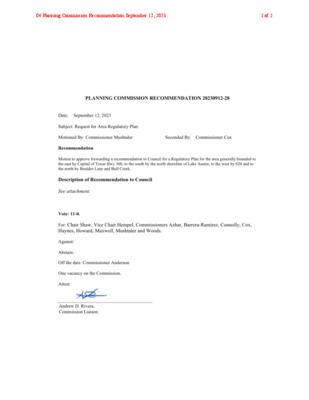
Submited by Commissioners Mushtaler and Cox Item 28 Dra� – Recommenda�on Whereas the general boundaries s�pulated have been iden�fied as one of the na�on's riskiest areas for uncontrolled wildfire; whereas the general boundaries include recently annexed geographies that lack city services, infrastructure and planning; whereas the general boundaries have amongst the highest popula�on growth rates in the city; whereas the insurance industry has iden�fied this area as high risk or uninsurable; whereas this is a cri�cal �me to expand safe and affordable housing opportuni�es; whereas the city's most valuable resources for climate resiliency occupy this region; whereas the lack of a regulatory plan could result extreme loss of human life and catastrophic financial disaster Planning Commission requests Council ini�ate a generalized regulatory plan to evaluate and improve roadway capaci�es, to evaluate and improve city services such as public transit and mul�modal transporta�on, to evaluate and plan appropriate growth capacity along the WUI corridor including affordable housing and missing middle housing, to evaluate and plan city's preserve lands and strategic acquisi�ons. 08 Planning Commission Recommendation September 12, 20231 of 1
ZONING AND PLATTING COMMISION REGULAR CALLED REVISED MEETING MINUTES TUESDAY, JUNE 3, 2025 The Zoning and Platting convened in a regular meeting on Tuesday, June 3, 2025, at Austin City Hall, Council Chambers, Room 1001, 301 W. Second Street, in Austin, Texas. Chair Smith called the Zoning and Platting Meeting to order at 6:01 p.m. Commissioners in Attendance: Hank Smith Betsy Greenberg Luis Osta Lugo Lonny Stern Commissioners in Attendance Remotely: Scott Boone Alejandra Flores David Fouts Taylor Major Ryan Puzycki Christian Tschoepe Commissioners Absent: Felix De Portu PUBLIC COMMUNICATION: GENERAL Jennifer Mushtaler – Consideration of the September 12, 2023, Planning Commission recommendation. APPROVAL OF MINUTES 1. Approve the minutes of the Zoning and Platting Commission regular meeting on Tuesday, May 20, 2025. 1 The minutes from the meeting of May 20, 2025, were approved on the consent agenda on Commissioner Stern’s motion, Commissioner Flores’ second on a 10-0 vote. Commissioner De Portu was absent. PUBLIC HEARINGS 2. Rezoning: Location: C14-2024-0159 - Research Park PDA Amendment; District 6 12219 ½, 12455, 12487 ½, 12489, 12489 ½, 12491 ½, 12501, 12515 ½, 12517 ½ Research Boulevard Service Road Southbound, 12220 ½ Riata Trace Parkway, 6511 ½ and 6513 McNeil Road, Walnut Creek and Rattan Creek Watersheds Owner/Applicant: Karlin Research Park Development, LLC, Karlin Research Park, LLC Agent: Request: Staff Rec.: Staff: (Matthew Schwab) Armbrust & Brown, PLLC (Richard T. Suttle) LI-PDA to LI-PDA, to change a condition of zoning Recommended, with conditions Sherri Sirwaitis, 512-974-3057, sherri.sirwaitis@austintexas.gov Planning Department The motion to approve Staff’s recommendation of LI-PDA, with conditions, to change a condition of zoning, for C14-2024-0159 - Research Park PDA Amendment; District 6, located at 12219 ½, 12455, 12487 ½, 12489, 12489 ½, 12491 ½, 12501, 12515 ½, 12517 ½ Research Boulevard Service Road Southbound, 12220 ½ Riata Trace Parkway, 6511 ½ and 6513 McNeil Road, was approved on the consent agenda on Commissioner Stern’s motion, Commissioner Flores’ second, on a 9-1 vote. Vice Chair Greenberg voted nay. Commissioner De Portu was absent. 2 3. Rezoning: Location: C14-2024-0170 - Duval PDA; District 6 5501 Duval Road; 11705, 11755, 11755 ½, 11757 ½, 11781 ½, 11785 ½, 11801 ½, Research Boulevard SVRD NB, 11900, 11900 ½, 11902 ½, 11904 ½ West Cow Path, Walnut Creek Watershed Owner/Applicant: Karlin Duval, LLC (Matthew Schwab) Agent: Request: Staff Rec.: Staff: Armbrust & Brown, PLLC (Richard T. Suttle) LI, LI-CO and LO to LI-PDA Recommended, with …
ZONING AND PLATTING COMMISION REGULAR CALLED MEETING TUESDAY, JUNE 17, 2025 The Zoning and Platting convened in a regular meeting on Tuesday, June 17, 2025, at Austin City Hall, Council Chambers, Room 1001, 301 W. Second Street, in Austin, Texas. Chair Smith called the Zoning and Platting Meeting to order at 6:01 p.m. Commissioners in Attendance: Hank Smith Betsy Greenberg Alejandra Flores Ryan Puzycki Commissioners in Attendance Remotely: Scott Boone David Fouts Taylor Major Lonny Stern Christian Tschoepe Commissioners Absent: Luis Osta Lugo 1 vacancy on the dais. PUBLIC COMMUNICATION: GENERAL None. APPROVAL OF MINUTES 1. Approve the minutes of the Zoning and Platting Commission regular meeting on Tuesday, June 3, 2025. 1 The minutes from the meeting of Tuesday, June 3, 2025, were approved on the consent agenda on Vice Chair Greenberg’s motion, Commissioner Puzycki’s second, on a 9-0 vote. Commissioner Osta Lugo was absent. One vacancy on the dais. PUBLIC HEARINGS C14-2025-0050 - North Loop Community Commercial; District 7 2302 and 2304 West North Loop Boulevard, Shoal Creek Watershed 2. Rezoning: Location: Owner/Applicant: Cuisines of Mexico Inc. Agent: Request: Staff Rec.: Staff: Thrower Design, LLC (Ron Thrower & Victoria Haase) LR to GR Recommended Cynthia Hadri, 512-974-7620, cynthia.hadri@austintexas.gov Planning Department The motion to approve Staff’s Recommendation of GR for C14-2025-0050 - North Loop Community Commercial; District 7, located at 2302 and 2304 West North Loop Boulevard, was approved on the consent agenda on Vice Chair Greenberg’s motion, Commissioner Puzycki’s second, on a 9-0 vote. Commissioner Osta Lugo was absent. One vacancy on the dais. C14-2025-0002 - Cooper Apartments; District 5 7804 Cooper Lane, South Boggy Creek Watershed 3. Rezoning: Location: Owner/Applicant: 7804 Cooper Lane LLC (Stephen Stokes) 7804 Cooper Lane LLC (Stephen Stokes) Agent: SF-3-CO to MF-3 Request: Staff Rec.: Recommendation of MF-2 Nancy Estrada, 512-974-7617, nancy.estrada@austintexas.gov Staff: Planning Department The public hearing was closed on Commissioner Puzycki’s motion, Comissioner Flores’ second, on a 9-0 vote. Commissioner Osta Lugo was absent. One vacancy on the dais. The motion to approve Staff’s recommendation of MF-2 for C14-2025-0002 - Cooper Apartments, located at 7804 Cooper Lane, was approved on Vice Chair Greenberg’s motion, Commissioner Puzycki’s second, on a 9-0 vote. Commissioner Osta Lugo was absent. One vacancy on the dais. 2 4. Rezoning: Location: C14-2024-0092 - Allred, Riddle, and W. Slaughter; District 5 2205, 2207, 2209 & 2200 Riddle Rode; 2200, 2202, 2206, 2208, 2300, 2102, 2104, 2106, 2108, 2014 …