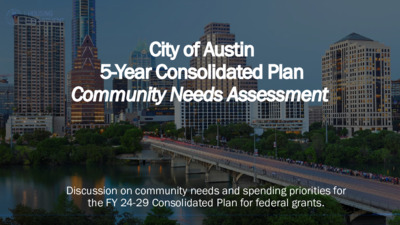
Discussion on community needs and spending priorities for the FY 24-29 Consolidated Plan for federal grants. Agenda Where Does Our Funding Come From? Planning and Reporting for Federal Funding How We Make Decisions Fair Housing Programs and Activities Overview What We've Heard From the Community Group and Community Input How do we fund our programs? HUD Annual Entitlement Grants Housing Trust Fund Approved City Bonds City Operating Budget Project Connect Anti-Displacement Funds CARES Act Federal Grants: Planning & Reporting Programs & Activites The U.S. Department of Housing and Urban Development (HUD) allocates entitlement funding to municipalities and state governments. The City of Austin applies for what in recent years has been approximately $14 million in annual grant entitlements across four grants for affordable housing, community development, economic development, and public services. Each year, we plan and evaluate the programs funded by the HUD grants. 5 U.S. Department of Housing and Urban Development (HUD) Consolidated Plan (5-Year) Allocates federal resources to housing and community development Action Plan (1-Year) Summarizes actions, activities and federal/non- federal resources in the Consolidated Plan Consolidated Annual Performance and Evaluation Report (CAPER) (1-Year) End-of-year report on progress toward consolidated plan 6 How are funding decisions made? We are here Community Participation: Community Needs Assessment Available Use of Funding Sources Consolidated Plan Housing Needs & Market Analysis Other Planning Efforts Austin Strategic Housing Blueprint Analysis of Impediments to Fair Housing Choice 7 Consolidated Plan Funding Sources Community Development Block Grant (CDBG) Goal: Provide decent housing and a suitable living environment; expand economic opportunities for low-income people Housing Opportunities for Persons with AIDS (HOPWA) Goal: Benefit low-income persons living with HIV/AIDS and their families by providing supportive services and housing Consolidated Plan (5-Year) HOME Investment Partnerships (HOME) Goal: create affordable housing for low- income households Emergency Solutions Grant (ESG) Goal: Assist people to quickly regain stability in permanent housing after experiencing a housing crisis and/or homelessness 8 Fair Housing • 2019 Analysis of Impediments to Fair Housing Choice (AI) • Potential upcoming "Equity Plan" related to fair housing • Seeking input and surveying on fair housing issues, experiences 9 Programs & Activities 10 Who Do We Serve? Fiscal Year 22-23 Snapshot 64.4% 3,017 # households served FY 22-23 70.0% 60.0% 50.0% 40.0% 30.0% 20.0% 10.0% 0.0% 17.5% 16.7% Extremely Low Income (<30% MFI) Very Low Income (31%- 50% MFI) Low Income (51%-80% MFI) 1.4% 81%+ MFI *Income data does …
PLANNING COMMISSION AGENDA Tuesday, March 12, 2024 The Planning Commission will convene at 6:00 PM on Tuesday, March 12, 2024, at City Hall, Council Chambers 1001 301 W. Second Street, Austin, TX. Some members of the Planning Commission may be participating by videoconference. The meeting may be viewed online at: http://www.austintexas.gov/page/watch-atxn-live Greg Anderson – Secretary (District 4) Awais Azhar – Vice-Chair (Mayor) Nadia Barrera-Ramirez (District 3) Grayson Cox (District 10) Adam Haynes (Mayor) Claire Hempel – Chair (District 8) Patrick Howard (District 1) Ryan Johnson (District 7) Felicity Maxwell (District 5) Jennifer Mushtaler (District 6) Alberta Phillips (Mayor) Danielle Skidmore (District 9) Alice Woods – Parliamentarian (District 2) Ex-Officio Members Jessica Cohen – Chair of Board of Adjustment Jesús Garza – Interim City Manager Candace Hunter – AISD Board of Trustees Richard Mendoza – Director of Transportation and Public Works Andrew Rivera – Commission Liaison EXECUTIVE SESSION (No public discussion) The Planning Commission will announce it will go into Executive Session, if necessary, pursuant to Chapter 551 of the Texas Government Code, to receive advice from Legal Counsel on matters specifically listed on this agenda. The Commission may not conduct a closed meeting without the approval of the city Attorney: Chrissy Mann 512-974-2179 attorney. Private Consultation with Attorney – Section 551.071 PUBLIC COMMUNICATION The first four (4) speakers signed up prior to the closure of speaker registration will each be allowed a three-minute allotment to address their concerns regarding items not posted on the agenda. APPROVAL OF MINUTES 1. Approve the minutes of February 13, 2024 and February 27, 2024. PUBLIC HEARING 2. Plan Amendment: Location: 3. Rezoning: Location: Owner/Applicant: Agent: Request: Staff Rec.: Staff: Postponement Request: Owner/Applicant: Agent: Request: Staff Rec.: Staff: Postponement Request: NPA-2022-0020.01 - Industrial Blvd and Terry O Ln; District 3 439-511 Industrial Blvd (odd #s only), 515 Industrial Blvd & 4208 Terry O Lane, Blunn Creek and Williamson Creek Watersheds; South Congress Combined (East Congress) NP Area Basalt Cannon LLC, Delwau LLC, Jasdayal LLC, Lunar Y LLC, Ungar Holdings LLC. Civilitude, LLC (Nhat Ho) Industry to Mixed Use land use Pending Maureen Meredith, 512-974-2695, maureen.meredith@austintexas.gov Planning Department Staff postponement request to March 26, 2024. C14-2022-0062 - Industrial Blvd and Terry O Ln; District 3 439-511 Industrial Blvd (odd #s only), 515 Industrial Blvd & 4208 Terry O Lane, Blunn Creek and Williamson Creek Watersheds;South Congress Combined (East Congress) NP Area Basalt Cannon LLC, Delwau LLC, …
SPEAKER REGISTRATION All participants wishing to address the commission must register to speak. Public participation is available by teleconference or in-person. Teleconference Registration Registration for participation by teleconference closes on Tuesday, March 12, 2024 at 2:00 PM. Teleconference code and additional information to be provided after the closing of the teleconference registration period. In-Person Registration While in -person registrants are encourag ed to register in advance of the meeting, in- person registration closes at 5:30 p.m. the day of the meeting utilizing a mobile device to scan the below QR code which will be displayed in Council chambers. Mobile devices will also be available at the meeting for public use for the purpose of speaker registration . Speaker Donation of Time For discussion cases, speaker donation of time is an available option for in-person participants. Both the registered speaker donating time and the speaker recipient must be present when the public hearing is conducted. See chart below regarding speaker time allotments. Click on link below or scan the QR code and submit the form to register to speak. Speakers should submit a separate registration form for each item of interest. https://forms.office.com/g/irmTaGAqPp Please contact Andrew Rivera, Commission Liaison, for questions regarding speaker registration at Andrew.rivera@austintexas.gov or by phone 512-974-6508. Presentations and handouts are requested to be e-mailed to Commission Liaison Andrew Rivera at Andrew.rivera@austintexas.gov by 1:00 PM day of the meeting. PARKING & VALIDATION Parking is available at the City Hall parking garage and is free with validation. Speaker Testimony Time Allocation Public Hearing Cases Primary speaker in favor and primary speaker opposed 3 speakers in favor and 3 speakers opposed All other speakers in favor or opposed 5 minutes each, up to 8 minutes total with donated time. 3 minutes each, up to 6 minutes total with donated time. 1 minute each, up to 2 minutes total with donated time. DISCUSSION POSTPONEMENT Primary speaker in favor and primary speaker opposed 3 minutes. All other speakers in favor or opposed 2 minutes. Donation of time is not an option for discussion postponement. ORDER OF MEETING Determination of Quorum / Meeting Called to Order Reading of Proposed Consent Agenda *Vote and Disposal of Consent Agenda **Determination of Discussion Postponement Items Discussion Cases (Including public comment, staff and applicant / representative presentations) Other Business Adjournment * The consent agenda may be acted upon by one vote without separate discussion. Speakers are allowed to …
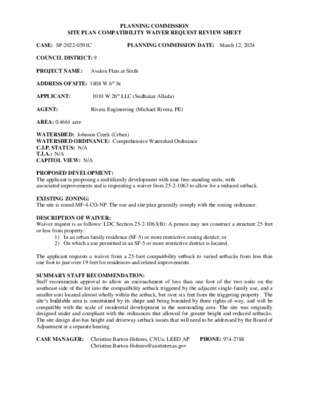
PLANNING COMMISSION SITE PLAN COMPATIBILITY WAIVER REQUEST REVIEW SHEET 1010 W 26th LLC (Sudhakar Allada) Rivera Engineering (Michael Rivera, PE) PLANNING COMMISSION DATE: March 12, 2024 CASE: SP-2022-0591C COUNCIL DISTRICT: 9 PROJECT NAME: Avalon Flats at Sixth ADDRESS OF SITE: 1808 W 6th St APPLICANT: AGENT: AREA: 0.4661 acre WATERSHED: Johnson Creek (Urban) WATERSHED ORDINANCE: Comprehensive Watershed Ordinance C.I.P. STATUS: N/A T.I.A.: N/A CAPITOL VIEW: N/A PROPOSED DEVELOPMENT: The applicant is proposing a multifamily development with nine free-standing units, with associated improvements and is requesting a waiver from 25-2-1063 to allow for a reduced setback. EXISTING ZONING: The site is zoned MF-4-CO-NP. The use and site plan generally comply with the zoning ordinance. DESCRIPTION OF WAIVER: Waiver request is as follows: LDC Section 25-2-1063(B): A person may not construct a structure 25 feet or less from property: 1) In an urban family residence (SF-5) or more restrictive zoning district; or 2) On which a use permitted in an SF-5 or more restrictive district is located. The applicant requests a waiver from a 25-foot compatibility setback to varied setbacks from less than one foot to just over 19 feet for residences and related improvements. SUMMARY STAFF RECOMMENDATION: Staff recommends approval to allow an encroachment of less than one foot of the two units on the southeast side of the lot into the compatibility setback triggered by the adjacent single-family use, and a smaller unit located almost wholly within the setback, but over six feet from the triggering property. The site’s buildable area is constrained by its shape and being bounded by three rights-of-way, and will be compatible with the scale of residential development in the surrounding area. The site was originally designed under and compliant with the ordinances that allowed for greater height and reduced setbacks. The site design also has height and driveway setback issues that will need to be addressed by the Board of Adjustment at a separate hearing. CASE MANAGER: Christine Barton-Holmes, CNUa, LEED AP Christine.Barton-Holmes@austintexas.gov PHONE: 974-2788 PROP. BUILDING CVR: 27.7% (5,642 sf) PROP. IMP. CVRG.: 65% (13,287 sf) PROPOSED F.A.R.: 0.75:1 PROP. HEIGHT: 30’/3 stories* PROVIDED PARKING: 24 spaces PROJECT INFORMATION: 20,342.5 sf EXIST. ZONING: MF-4-NP MAX. BLDG. COVERAGE : 60% MAX. IMPERV. CVRG.: 70% ALLOWED F.A.R.: 0.75:1 HEIGHT: 30’/2 stories REQUIRED PARKING: NA PROPOSED ACCESS: from W 6th St and Theresa Avenue *Pending outcome of BOA hearing SUMMARY COMMENTS ON SITE PLAN: Land Use: The …
Equitable Transit-Oriented Development ETOD and Imagine Austin Planning Commission 3/12/2024 Agenda Background Next Steps 1 2 3 ETOD and Imagine Austin Background 1 ETOD Policy Plan • Builds on CapMetro's Federal Transit Administration-funded ETOD Study. • Provides a comprehensive policy framework to guide future development around the Project Connect system. • It helps the Austin community ensure that the results of Project Connect support residents of all incomes and backgrounds, especially those that have been disproportionately burdened by transportation and land use decisions. ETOD Station Area Typologies If a station has… …and is… …and has experienced… More Residents Today Historically Exclusionary or Low Displacement Rapid Change More Residents Today Historically Exclusionary or Low Displacement Slow Change Fewer Residents Today Historically Exclusionary or Low Displacement Rapid Change Fewer Residents Today Historically Exclusionary or Low Displacement Slow Change More Residents Today Vulnerable to or Experiencing Displacement Rapid Change More Residents Today Vulnerable to or Experiencing Displacement Slow Change Fewer Residents Today Vulnerable to or Experiencing Displacement Rapid Change Fewer Residents Today Vulnerable to or Experiencing Displacement Slow Change ETOD and Imagine Austin 2 Council Action on March 9, 2023 – Resolution no. 20230309-016 Imagine Austin and ETOD • ETOD Typologies: • Consider existing population, recent growth and economic development, and displacement risk of households • Address types of growth most needed for equitable outcomes in a station area • Incorporating ETOD Typologies into Imagine Austin allows for: • Updating IA Compliance Checklist • Formal consideration in zoning and neighborhood plan amendment • Demonstrating alignment and transit-supportive policy to the Federal case review Transit Administration Comprehensive Plan Joint Committee Action on February 29, 2024 • ETOD Policy Map and Typologies with amendments was unanimously approved to be forwarded to the Planning Commission to be amended to Imagine Austin. • Amendments: • Inclusion of process for staff to incorporate latest available data • Inclusion of a footnote indicating the age of the data Imagine Austin and ETOD • The amendment to Imagine Austin will include: • The methodology through which staff developed the 8 ETOD Typologies • The 8 ETOD Typologies and their descriptions • The ETOD Typology map • A preface that provides context about the application of the ETOD Typologies and their map to Imagine Austin • Includes staff plan to update data, along with notation of data sources (incorporated from CPJC amendments). Next Steps 3 Imagine Austin- ETOD Amendment Timeline Briefing …
CPA-2024-0001 Exhibit A Background The Equitable Transit Oriented Development (ETOD) Policy Plan, accepted by City Council on March 9, 2023, through Resolution No. 20230309-016, included ETOD Typologies that are based on existing population, displacement risk, and relative change in population and jobs over the last decade. The resolution accepting the ETOD Policy Plan directed staff to initiate “amendments to the Imagine Austin Comprehensive Plan to reflect the ETOD Typologies included in the ETOD Policy Plan.” The purpose of the ETOD Policy Plan, including the ETOD Typologies, is to provide a policy framework to help Austin ensure that future development around the stations in the Project Connect transit system supports residents of all incomes and backgrounds, especially those who have been disproportionately burdened by past transportation and land use decisions. The ETOD Typologies The ETOD Typologies are intended to provide a snapshot of a station area’s current conditions. A station area is defined as roughly the ½ mile radius surrounding a station, or a 10-minute journey walking, biking, or rolling to or from a station. The eight Typologies were determined using several factors— existing population relative to other station areas, displacement risk of households, and the recent rate of change in jobs and population. More can be read about the methodology in the following pages. Because of their representation of current conditions in the station areas, the ETOD Typologies also speak to types of growth most needed for equitable outcomes in a station area. The ETOD Typology concept map shows the location of the different ETOD Typologies at station areas throughout the Project Connect system. The squares represent MetroRail and future Light Rail (rail) station areas, while the circles represent MetroRapid (bus) station areas. Although it is possible that some station locations may change as Project Connect engineering and design progresses in the future, Typologies based on the characteristics of any new station area locations will still be applied. Using the ETOD Typologies The ETOD Typologies provide additional context about what equitable growth should look like in a station area based on its characteristics and are intended to provide additional guidance to zoning and land use decision-making as city staff and decision makers evaluate recommended changes for consistency with the Imagine Austin Plan. Future Updates to the ETOD Typologies Staff will work to update the data used to inform the Typologies on a regular basis. Because of the small geographic scale …
BOARD/COMMISSION RECOMMENDATION Robert Mueller Municipal Airport Plan Implementation Advisory Commission Recommendation Number (20240312-003): Recommendation to Council to include funding in the FY2024-2025 Budget per the Mueller Parkland Maintenance Agreement (PMA) between the City of Austin Parks and Recreation Department and the Mueller Property Owners Association (POA). WHEREAS, on December 2, 2004 the City of Austin and Catellus Austin, LLC entered into a Master Development Agreement for the public-private partnership to redevelop the former Robert Mueller Municipal Airport, and, Section 8.2 calls for the City, subject to annual appropriation, to provide an annual payment to the POA to offset some of the maintenance costs for the Perimeter Parks that will be dedicated to the City; and WHEREAS, the $144,504 approved by City Council for the FY2023-2024 Parks and Recreation Department's budget covers a contribution towards maintaining the Northwest, Southwest, and a portion of the Southeast Perimeter Parks, but did not include the remainder of the Southeast Perimeter Park and its Skate Park and Pump Track facilities; and, WHEREAS, City Council approved the Mueller PMA on January 18, 2024 that authorizes the Mueller POA to continue to provide maintenance on the Perimeter Parks once they are dedicated to the City; and, WHEREAS, Under the terms of the PMA, the Mueller POA has requested a total of $257,140 for the FY2024-2025 PARD contribution towards the maintenance of all three Perimeter Parks, including the Skate Park and Pump Track; NOW, THEREFORE BE IT RESOLVED that the Robert Mueller Municipal Airport Plan Implementation Advisory Commission recommends that the Austin City Council include $257,140 in PARD's FY 2024- 2025 budget to adequately fund the City’s Maintenance Contribution for the Mueller Perimeter Parks. Date of Approval: ___________________________________________ Record of the vote: _________________________________________ Attest: ____________________________________________________________________ Jill Fagan, Liaison Robert Mueller Municipal Airport Plan Implementation Advisory Commission
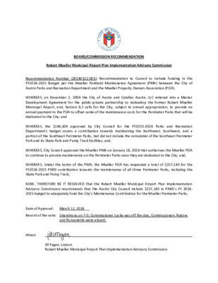
BOARD/COMMISSION RECOMMENDATION Robert Mueller Municipal Airport Plan Implementation Advisory Commission Recommendation Number (20240312-003): Recommendation to Council to include funding in the FY2024-2025 Budget per the Mueller Parkland Maintenance Agreement (PMA) between the City of Austin Parks and Recreation Department and the Mueller Property Owners Association (POA). WHEREAS, on December 2, 2004 the City of Austin and Catellus Austin, LLC entered into a Master Development Agreement for the public-private partnership to redevelop the former Robert Mueller Municipal Airport, and, Section 8.2 calls for the City, subject to annual appropriation, to provide an annual payment to the POA to offset some of the maintenance costs for the Perimeter Parks that will be dedicated to the City; and WHEREAS, the $144,504 approved by City Council for the FY2023-2024 Parks and Recreation Department's budget covers a contribution towards maintaining the Northwest, Southwest, and a portion of the Southeast Perimeter Parks, but did not include the remainder of the Southeast Perimeter Park and its Skate Park and Pump Track facilities; and, WHEREAS, City Council approved the Mueller PMA on January 18, 2024 that authorizes the Mueller POA to continue to provide maintenance on the Perimeter Parks once they are dedicated to the City; and, WHEREAS, Under the terms of the PMA, the Mueller POA has requested a total of $257,140 for the FY2024-2025 PARD contribution towards the maintenance of all three Perimeter Parks, including the Skate Park and Pump Track; NOW, THEREFORE BE IT RESOLVED that the Robert Mueller Municipal Airport Plan Implementation Advisory Commission recommends that the Austin City Council include $257,140 in PARD's FY 2024- 2025 budget to adequately fund the City’s Maintenance Contribution for the Mueller Perimeter Parks. Date of Approval: March 12, 2024 Record of the vote: Unanimous on 7-0; Commissioner Lucke was off the dais, Commissioners Rudow and Ronsonette were absent. Attest: Jill Fagan, Liaison Robert Mueller Municipal Airport Plan Implementation Advisory Commission
RMMA PIAC MEETING MINUTES Tuesday, March 12, 2024 ROBERT MUELLER MUNICIPAL AIRPORT PLAN IMPLEMENTATION ADVISORY COMMISSION REGULAR MEETING MINUTES TUESDAY, MARCH 12, 2024 The Robert Mueller Municipal Airport Plan Implementation Advisory Commission convened in a regular meeting on Tuesday, March 12, 2024, at the Austin Energy Headquarters located at 4815 Mueller Boulevard Austin, TX 78723. The meeting was also offered via videoconference. Chair Jones called the Robert Mueller Municipal Airport Plan Implementation Advisory Commission Meeting to order at 6:01 p.m. Commission Members in Attendance: • Michael Jones, Chair • Rick Krivoniak, Vice-Chair • Andrew Clements • Corky Hilliard • Martin Luecke • Christopher Jackson • David Neider • Kathy Sokolic Commission Members in Attendance Remotely: PUBLIC COMMUNICATION: GENERAL • None 1. None APPROVAL OF MINUTES 2. Minutes from the February 13, 2024, meeting was approved on Commissioner Krivoniak’s motion, Commissioner Hilliard’s second on a 7-0 vote; Commissioner Lucke was off the dais, Commissioners Rudow and Ronsonette were absent. 3. Staff update on Boards and Commissions April Officer Elections: Pam Hefner (Economic Development Department) reminded Commissioners that current officer terms expire at the end of April and new officers will be elected at the next meeting. STAFF BRIEFING 1 RMMA PIAC MEETING MINUTES DISCUSSION AND ACTION ITEMS Tuesday, March 12, 2024 4. Discussion by Commission regarding possible recommendation on the City’s Fiscal Year 2025 Budget related to Mueller Perimeter Parks Maintenance. a. The motion to recommend the maintenance budget request for Mueller Perimeter Parks was approved on Commissioner Clements’ motion, Commissioner Sokolic’s second on a 7-0 vote; Commissioner Lucke was off the dais, Commissioners Rudow and Ronsonette were absent. WORKING GROUP/COMMITTEE UPDATES 5. Update from Mueller Transition Working Group: Update was given by Commissioner Hilliard on conversations held with Mueller stakeholder groups and asked Commissioners to provide recommendations on additional groups to contact. Commissioner Clements suggested reaching out to the EC/TC Board (the Commercial Board of the Mueller Property Owner’s Association). FUTURE AGENDA ITEMS Chair Jones asked the Commissioners to provide suggestions for potential future agenda items to be sent to him via email. Commissioners brought up the following topics at the meeting: • Update on Minority Owned or Women Owned Business Enterprises • Update on remaining infrastructure, including the Control Tower, parks and trails • Update on Mueller Financials • April Officer Elections and Annual Report Discussion • Update on East 51st Street Bond Project • Discussion on the Browning …
# 1 2 3 Prime SOW Subs Prime SOW Subs Prime SOW Subs Prime SOW Subs Prime SOW Subs Prime SOW Specialty Offshore, Inc. 96226 - Diving Services - 100% No subcontracting opportunities - Single scope of work Austin Alliance Group, LLC 91838 - Education and Training Consulting - 100% No subcontracting opportunities - Single scope of work Belfor USA Group, Inc. / Belfor Property Restoration 91024 - Fire And/Or Water Damage Restoration Services - 98% 9107366 - Restoration, Refurbishing, Maintenance And Repair, Tile - 2% No subcontracting opportunities - BuyBoard Cooperative Agreement Cotton Commercial USA, Inc. 91024 - Fire And/Or Water Damage Restoration Services - 98% 9107366 - Restoration, Refurbishing, Maintenance And Repair, Tile - 2% No subcontracting opportunities - BuyBoard Cooperative Agreement Mooring Recovery Services, Inc. / Mooring USA 91024 - Fire And/Or Water Damage Restoration Services - 98% 9107366 - Restoration, Refurbishing, Maintenance And Repair, Tile - 2% No subcontracting opportunities - BuyBoard Cooperative Agreement Eis Design, Inc. 91522 - Communication Marketing Services - 80% 9157355 - Outreach Services - 10% 91827 - Community Development Consulting - 10% Subs (FH) Taylor Collective Solutions, LLC (FW) Macwatson Enterprises, Inc. / Prographix (FB) Kara E. Henderson / Mindful Media, LLC Sourcing No Sourcing Name Category Contract Amount Prime MBE AA H A/NA WBE DBE Sponsor Department Council Date Goals Met Procurement Type Goals/No Goals MBE/ WBE Non Sub AMA1090 Underwater Diving Inspections Water and Waste NG $740,000 over 5 years Li Yang Austin Water 1/18/2024 N/A IFB-IDIQ FY2024 Council Awards Report January 2024 139221 Executive Leadership Training (Multi-Department) General Services NG $450,000 over 3 years Jackson Dodd 1/18/2024 N/A Austin Public Health Non-Professional Services 139165 Non-Construction Restoration and Remediation Services Facilities and Grounds NG Steven Stenton Financial Services 1/18/2024 N/A Cooperative Agreement $2,550,000 over 5 years each 4 AVB4007 Marketing Support for ACC Expansion Project General Services $1,200,00 over 6 years 2.16 SG MG 97.08 0.76 2.92 Elisa Folco Austin Convention Center 1/18/2024 Yes Non-Professional Services Percent of "Met Goal" Awards for FY2024 Percent of "Met Goal" Awards for FY24 To-Date 100.00% 100.00% B= African American/ Black W= Caucasian/White SG= Solicitation Goal UNK=Unknown Participation H= Hispanic/ Latino F= Female MG= Met Goal A/N= Asian/Asian/Native American M= Male GFE= Good Faith Effort PTD= Participation To Date Non-Sub= Subcontractor Not Certified MBE/WBE=Combined Goals Council Awards Report PAGE 1 OF 2 Solicitation No Cost Estimate Award Amount Prime MBE AA H A/NA …
City of Austin Disparity Study 2022 Colette Holt & Associates Adisa Communications Cultural Strategies, Inc. Pink Consulting Disparity Study Legal Standards ▪ In 1989, US Supreme Court held race- and gender-conscious programs are subject to “strict scrutiny”, the highest level of judicial review ▪ M/W/DBE programs must meet two tests • Agency must prove it has a “compelling interest” based on “strong” statistical and anecdotal evidence of current discrimination or the effects of past discrimination in using race or gender in decision- making • Any remedies must be “narrowly tailored” to the evidence relied upon and regularly reviewed 2 Recent Legal Developments ▪ USDA “socially and economically disadvantaged” farmers program under American Rescue Plan struck down by three trial courts and class status granted ▪ Priority for grants to small restaurants owned by “socially and economically disadvantaged” persons, women and veterans struck down ▪ Oregon’s COVID relief fund for Blacks and Colorado’s fund for MBEs challenged and enjoined 3 Disparity Study Objectives ▪ Provide a legal defense for a government program if the program is challenged ▪ Meet constitutional requirements ▪ Provide policy and program recommendations ▪ Educate policy makers and stakeholders about the legal and economic issues to build consensus 4 Disparity Study Data and Methods ▪ Quantitative data sources • City contract and vendor records • Contract information from prime vendors • M/W/DBE/HUB Directories • Hoovers/Dun & Bradstreet • U.S. Census Bureau • Scholarly research ▪ Qualitative data sources • Business owner and stakeholder interviews • Electronic survey • City staff 5 Disparity Study Elements ▪ Legal review and analysis ▪ MBE/WBE Program review ▪ Utilization, availability and disparity analyses • Determination of City’s geographic and industry • Determination of MBE/WBE utilization in these markets markets • Estimation of MBE/WBE availability in these markets • Calculation of disparity ratios ▪ Economy-wide disparity analysis ▪ Anecdotal data collection and analysis ▪ Recommendations 6 Disparity Study Findings: Utilization ▪ Study analyzed FYs 2013-2018 contracts $50,000 or greater • Final Contract Data File ▪ 1,002 prime contracts totaling $826,453,073.73 ▪ 842 subcontracts totaling $249,783,337.28 ▪ Geographic market • 19 counties with Austin, San Antonio, Dallas-Fort Worth and Houston metro areas captured 82.9% of the Final Contract Data File ▪ Product market • 204 NAICS codes in Final Contract Data File 7 Disparity Study Findings: Utilization ▪ City’s utilization of M/WBEs ▪ MBEs: 9.6% • Blacks: 1.7% • Hispanics: 5.8% • Asians: …
City of Austin Small and Minority Business Resources COA Goal Setting March 12, 2024 Edward Campos, Director Goal Setting Process • All COA solicitations with a projected value of $50K or greater are reviewed for project-specific goals • Project is assigned to a Business Development Counselor (BDC) for review and initial goal determination • Approval of determination based on complexity of procurement and recommendation of goal type • Final determination sent to Procurement Specialist/Contract Manager City of Austin | SMBR 2 What Documents/Tools do we use? • Solicitation document(s) provides project overview • Trade Summary Sheet identifies scopes of work o Minimum of at least 2 scopes of work o Minimum total of at least 3 certified MBE/WBEs • Percentages reflect the anticipated amount of materials/supplies/services/work involved in the project City of Austin | SMBR 3 Trade Summary City of Austin | SMBR 4 Goal Formula – eCAPRIS System City of Austin | SMBR 5 Project Specific Goal Calculation Why Would the City not establish goals on a project? • Exemptions to the MBE/WBE Procurement Program where goals cannot be established • Sole Sources, Cooperative Agreements, Critical Business Needs, Ratifications • Insufficient Scopes of Work • Minimum of 2 distinct scopes of work • Referenced project identified one scope of work • Insufficient Availability of MBE and WBE firms City of Austin | SMBR 7 City of Austin Small & Minority Business Resources Department Questions?
MBE/WBE and Small Business Enterprise Procurement Program Advisory Committee MEETING MINUTES The MBE/WBE and Small Business Enterprise Procurement Program Advisory Committee convened in a regular meeting on Tuesday, March 12, 2024. Members attended both virtually and in‐person at the City of Austin Permit and Development Center at 6310 Wilhelmina Delco Drive, Room 1215 in Austin, TX. CALL TO ORDER Committee Chair, Ahmed Moledina called the meeting to order at 5:39pm. COMMITTEE MEMBERS IN ATTENDANCE: In‐Person: Virtual: Ahmed Moledina (Chair) Lena Banks (Vice Chair), Amin Dhukka, Terry Mitchell, Julio Rojas‐Aguilar, Salman Rashid Erica Douglass, Talan Tyminski, TK Tunchez Absent: PUBLIC COMMUNICATION: GENERAL None APPROVAL OF MINUTES 1. Approve the minutes from the MBE/WBE Advisory Committee Regular Meeting on February 6, 2024. The minutes were considered for approval and approved on a motion by Committee Vice Chair, Lena Banks and seconded by Committee Member, Amin Dhukka. Approved on a 6‐0 vote. DISCUSSION 2. Overview of the 2022 Disparity Study by Colette Holt of Colette, Holt & Associates. The data and recommendations from the 2022 Disparity Study conducted by Colette, Holt & Associates were presented to the new members of the committee. 3. Overview of MBE/WBE Goal Setting by SMBR Acting Assistant Director, Felecia Shaw. SMBR Director, Edward Campos gave the presentation in Acting Assistant Director Shaw’s absence. The presentation outlined City’s process when establishing minority and women‐owned business goals on a project. STAFF BRIEFINGS 4. Briefing from the Director on initiatives related to SMBR. SMBR Director, Edward Campos briefed the Committee on the following: o SMBR will present to the City's Audit and Finance Committee on March 27th. The Committee will be updated on the Personal Net Worth process, status of work on the ordinance and rule revisions, and an overview of the annual procurement forecasts and annual aspirational goals. Page 1 of 2 Office. report. FUTURE AGENDA ITEMS Next Month’s Agenda: Future Items: o Presented some key information provided to the Boards and Commissions by the City Clerk’s 5. Briefing from the SMBR staff on the Council Awards and Certification Roll reports. SMBR Assistant Director, Tamela Saldana provided the updates on the Council Awards reports. SMBR Certification Division Manager, Elton Price provided the update on the Certification Roll Officer elections for Chair and Vice‐Chair Presentation on the development of the Annual Aspirational MBE/WBE Goals Staff briefings (Director’s updates and staff …
PLANNING COMMISSION March 12, 2024 MINUTES The Planning Commission convened in a meeting on March 12, 2024, in Council Chambers of City Hall, 301 W. 2nd Street, Austin, Texas and via videoconference @ http://www.austintexas.gov/page/watch-atxn-live Vice-Chair Azhar called the Commission Meeting to order at 6:10 p.m. Commission Members in Attendance: Greg Anderson- Secretary Awais Azhar -Vice-Chair Nadia Barrera-Ramirez Grayson Cox Adam Haynes Patrick Howard Felicity Maxwell Alberta Phillips Danielle Skidmore Alberta Phillips Alice Woods Jessica Cohen – Ex-Officio Absent: Claire Hempel - Chair Jennifer Mushtaler Candice Hunter - Ex-Officio Richard Mendoza – Ex-Officio Jesús Garza– Ex-Officio PUBLIC COMMUNICATION The first four (4) speakers signed up prior to the closure of speaker registration will each be allowed a three-minute allotment to address their concerns regarding items not posted on the agenda. Mr. Santiago – Conveyed his concerns regarding the demolition of a bridge over the Colorado River. APPROVAL OF MINUTES 1. Approve the minutes of February 13, 2024 and February 27, 2024. Approve minutes from February 13, 2024 and postpone minutes of February 27, 2024 was approved on the consent agenda on the motion by Commissioner Woods, seconded by Commissioner Maxwell on a vote of 11-0. Chair Hempel and Commissioner Mushtaler absent. PUBLIC HEARING Location: 2. Plan Amendment: NPA-2022-0020.01 - Industrial Blvd and Terry O Ln; District 3 439-511 Industrial Blvd (odd #s only), 515 Industrial Blvd & 4208 Terry O Lane, Blunn Creek and Williamson Creek Watersheds; South Congress Combined (East Congress) NP Area Owner/Applicant: Basalt Cannon LLC, Delwau LLC, Jasdayal LLC, Lunar Y LLC, Agent: Request: Staff Rec.: Staff: Postponement Request: Ungar Holdings LLC. Civilitude, LLC (Nhat Ho) Industry to Mixed Use land use Pending Maureen Meredith, 512-974-2695, maureen.meredith@austintexas.gov Planning Department Staff postponement request to March 26, 2024. Motion to grant Staff’ request for postponement of this item to March 26, 2024 was approved on the consent agenda on the motion by Commissioner Woods, seconded by Commissioner Maxwell on a vote of 11-0. Chair Hempel and Commissioner Mushtaler absent. 3. Rezoning: Location: C14-2022-0062 - Industrial Blvd and Terry O Ln; District 3 439-511 Industrial Blvd (odd #s only), 515 Industrial Blvd & 4208 Terry O Lane, Blunn Creek and Williamson Creek Watersheds;South Congress Combined (East Congress) NP Area Owner/Applicant: Basalt Cannon LLC, Delwau LLC, Jasdayal LLC, Lunar Y LLC, Agent: Request: Staff Rec.: Staff: Postponement Request: Ungar Holdings LLC. Civilitude, LLC (Nhat Ho) LI-NP to LI-PDA-NP Pending Nancy Estrada, 512-974-7617, …
BOARD OF ADJUSTMENT REGULAR MEETING MINUTES MONDAY, January 8, 2024 The BOARD OF ADJUSTMENT convened in a Regular meeting on Monday, January 8, 2024, at 301 West 2nd Street in Austin, Texas. Chair Jessica Cohen called the Board of Adjustment Meeting to order at 5:44 p.m. Board Members/Commissioners in Attendance in-Person: Jessica Cohen-Chair, Melissa Hawthorne-Vice Chair, Jeffery Bowen, Brian Poteet, Maggie Shahrestani, Michael Von Ohlen, Janel Venzant Board Members/Commissioners in Attendance Remotely: Thomas Ates, Marcel Gutierrez-Garza, Yung-ji Kim Board Member/Commissioners absent: None PUBLIC COMMUNICATION: GENERAL The first (4) four speakers signed up/register prior (no later than noon the day before the meeting) to the meeting being called to order will each be allowed a three-minute allotment to address their concerns regarding items not posted on the agenda. None APPROVAL OF MINUTES 1. Approve the minutes of the Board of Adjustment Regular meeting on December 11, 2023. On-Line Link: DRAFT MINUTES December 11, 2023 Vice-Chair Melissa Hawthorne motions to approve the minutes for December 11, 2023, Board member Michael Von Ohlen seconds on 10-0; APPROVED MINUTES FOR December 11, 2023. PUBLIC HEARINGS Discussion and action on the following cases. New Variance cases: C15-2023-0051 Linda Sullivan for Suzanne McFayden-Smith – Lotus Management 3. Trust 4400 Waterford Place On-Line Link: ITEM03 ADV PACKET; PRESENTATION; AE APPROVAL The applicant is requesting variance(s) from the Land Development Code, Section 25-2-551 (Lake Austin District Regulations): 25-2-551(C)(2)(a) increase the maximum impervious cover on a slope with a gradient of 25 percent or less from 20 percent (maximum allowed) to 47.4 percent (requested), and 25-2-551(C)(2)(b) increase the maximum impervious cover on a slope with a gradient of 25 percent and not more than 35 percent from 10 percent (maximum allowed) to 17.8 percent (requested), in order to remodel an uncovered wood deck in a “LA” and “DR”, Lake Austin and Development Reserve zoning district. Note: 25-2-551 Lake Austin (LA) District Regulations (C) This subsection specifies lot width and impervious cover restrictions in a Lake Austin (LA) district. (2) For a lot included in a subdivision plat recorded after April 22, 1982, impervious cover may not exceed: (a) 20 percent, on a slope with a gradient of 25 percent or less; (b) 10 percent, on a slope with a gradient of more than 25 percent and not more than 35 percent; or (c) if impervious cover is transferred under Subsection (D), 30 percent. For the above address the Subdivision …
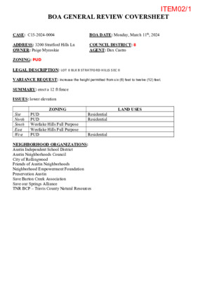
BOA GENERAL REVIEW COVERSHEET CASE: C15-2024-0004 BOA DATE: Monday, March 11th, 2024 COUNCIL DISTRICT: 8 AGENT: Dax Castro ADDRESS: 3200 Stratford Hills Ln OWNER: Paige Mycoskie ZONING: PUD LEGAL DESCRIPTION: LOT 8 BLK B STRATFORD HILLS SEC II VARIANCE REQUEST: increase the height permitted from six (6) feet to twelve (12) feet. SUMMARY: erect a 12 ft fence ISSUES: lower elevation LAND USES ZONING PUD PUD Site North South Westlake Hills Full Purpose East Westlake Hills Full Purpose West PUD Residential Residential Residential NEIGHBORHOOD ORGANIZATIONS: Austin Independent School District Austin Neighborhoods Council City of Rollingwood Friends of Austin Neighborhoods Neighborhood Empowerment Foundation Preservation Austin Save Barton Creek Association Save our Springs Alliance TNR BCP – Travis County Natural Resources ITEM02/1 Board of Adjustment General/Parking Variance Application DevelopmentATX.com | Phone: 311 (or 512-974-2000 outside Austin) For submittal and fee information, see austintexas.gov/digitaldevelopment WARNING: Filing of this appeal stops all affected construction activity. This application is a fillable PDF that can be completed electronically. To ensure your information is saved, click here to Save the form to your computer, then open your copy and continue. The Tab key may be used to navigate to each field; Shift + Tab moves to the previous field. The Enter key activates links, emails, and buttons. Use the Up & Down Arrow keys to scroll through drop-down lists and check boxes, and hit Enter to make a selection. The application must be complete and accurate prior to submittal. If more space is required, please complete Section 6 as needed. All information is required (if applicable). For Office Use Only Case # __________________ ROW # ___________________ Tax # ____________________ 13261995 C15-2024-0004 0113110508 Section 1: Applicant Statement Street Address: __________________________________________________________________ Subdivision Legal Description: ____________________________________________________________________________ ____________________________________________________________________________ Lot(s): _________________________________ Block(s): _____________________________ Outlot: _________________________________ Division: _____________________________ Zoning District: ___________________________________________________________________ I/We ________________________________________________ on behalf of myself/ourselves as authorized agent for ________________________________________________ affirm that on Month , Day , Year , hereby apply for a hearing before the Board of Adjustment for consideration to (select appropriate option below): Erect Attach Complete Remodel Maintain Other: ____________ Type of Structure: ______________________________________________________________ City of Austin | Board of Adjustment General/Parking Variance Application 2/9/22 | Page 4 of 8 ITEM02/2 Portion of the City of Austin Land Development Code applicant is seeking a variance from: ____________________________________________________________________________ ____________________________________________________________________________ ____________________________________________________________________________ ____________________________________________________________________________ Section 2: Variance Findings The Board must determine the existence of, sufficiency of, and weight of evidence supporting …