Natural Gas Energy Efficiency Pilot Proposal Austin, TX Resource Management Commission January 18, 2022 Overview Purpose of Pilot CenterPoint Energy proposes to introduce targeted program offerings that will deliver cost- effective energy savings, promote awareness of energy conservation, and provide customers in Austin Texas with opportunities to reduce natural gas usage in their homes and businesses. • Specific Objectives affordability of energy; • Reduce end-use natural gas consumption to conserve resources and improve • Provide environmental benefits by influencing the use of energy efficient equipment and technology that reduces carbon dioxide emissions and other greenhouse gases; and • Promote energy-conscious attitudes and behaviors that support energy conservation and sustainability 2 Overview Pilot Development The Pilot is designed with a “Quick-Start” approach and offers programs that can be implemented with minimal budget and complexity while still providing cost-effective energy-savings opportunities to customers. • Factors Evaluated in Pilot Design Identify programs best suited for a small-scale pilot Develop measure level energy savings Develop cost projections Evaluate cost-effectiveness Determine the most effective marketing and delivery channels • Proposed Program Offerings Prescriptive Equipment Rebates DIY Home Conservation Improvement Products Commercial Direct Install Equipment • • • • • • • • 3 Overview Pilot Plan Summary • Projections Budget: $20,114 Annual Energy Savings: 9,488 Ccf Net Economic Benefits: $29,148 • Implementation Period • Eleven-month pilot (February 2022 – December 2022) • Funding • • • • The Company seeks to recover program costs concurrently with implementation of the pilot through a ratepayer funded mechanism. 4 High Efficiency Equipment Rebates Description The High-Efficiency Equipment Rebates program is designed to promote energy-efficient retrofits by offering incentives to customers for the purchase and installation of new high- efficiency natural gas equipment. • Eligible Equipment Equipment Efficiency Customer Rebate Natural Gas Force Air Furnace 95% AFUE or Higher Natural Gas Tankless Water Heater .87 UEF or Higher Natural Gas Storage Tank Water Heater .70 UEF or Higher Smart Thermostat ENERGY STAR Qualified $600 $350 $100 $50 • Program Projections Budget: $10,500 • • • • Annual Energy Savings: 2,213 Ccf Net Economic Benefits: $9,701 Participating Customers: 35 5 Home Conservation Improvement Products Description CenterPoint Energy’s Home Conservation Improvement Products program will provide free water and energy saving equipment to residential customers. • Eligible Equipment Low-Flow Showerheads Low-Flow Kitchen Faucet Aerators Low-Flow Bathroom Faucet Aerators • Program Projections Budget: $2,989 Annual Energy Savings: 890 Ccf Net Economic Benefits: $3,164 …
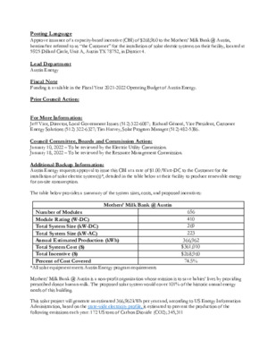
..De Posting Language ..Title Approve issuance of a capacity-based incentive (CBI) of $268,960 to the Mothers’ Milk Bank @ Austin, hereinafter referred to as “the Customer” for the installation of solar electric systems on their facility, located at 5925 Dillard Circle, Unit A, Austin TX 78752, in District 4. Lead Department Austin Energy Fiscal Note Funding is available in the Fiscal Year 2021-2022 Operating Budget of Austin Energy. Prior Council Action: For More Information: Jeff Vice, Director, Local Government Issues (512) 322-6087; Richard Génecé, Vice President, Customer Energy Solutions (512) 322-6327; Tim Harvey, Solar Program Manager (512) 482-5386. Council Committee, Boards and Commission Action: January 10, 2022 – To be reviewed by the Electric Utility Commission. January 18, 2022 – To be reviewed by the Resource Management Commission. Additional Backup Information: Austin Energy requests approval to issue this CBI at a rate of $1.00/Watt-DC to the Customer for the installation of solar electric system(s)*, detailed in the table below at their facility to produce renewable energy for on-site consumption. The table below provides a summary of the system sizes, costs, and proposed incentives: Mothers’ Milk Bank @ Austin Number of Modules Module Rating (W-DC) Total System Size (kW-DC) Total System Size (kW-AC) Annual Estimated Production (kWh) Total System Cost ($) Total Incentive ($) Percent of Cost Covered 656 410 269 223 366,962 $361,010 $268,960 74.5% *All solar equipment meets Austin Energy program requirements Mothers’ Milk Bank @ Austin is a non-profit organization whose mission is to save babies’ lives by providing prescribed donor human milk. The proposed solar system would cover 101% of the historic annual energy needs of this building. This solar project will generate an estimated 366,962 kWh per year and, according to US Energy Information Administration, based on the state-wide electricity profile, is estimated to prevent the production of the following emissions each year: 172 US tons of Carbon Dioxide (CO2); 345,311 pounds of Sulfur Dioxide (SO2); and 257 pounds of Nitrogen Oxide (NOX). According to the Environmental Protection Agency (EPA)’s Greenhouse Gas Equivalency Calculator, these emissions reductions are equivalent to planting 2,580 trees or 191 acres of forest in Austin's parks or the removal of 392,149 vehicle miles or 33.9 cars from Austin roadways. According to the updated Austin Energy Resource, Generation and Climate Protection Plan, approved by Austin City Council in March 2020, “Austin Energy will achieve a total of 375 MW of local solar …
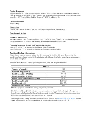
..De Posting Language ..Title Approve issuance of a capacity-based incentive (CBI) of $141,750 to the Michael & Susan Dell Foundation (MSDF), hereinafter referred to as “the Customer” for the installation of solar electric systems on their facility, located at 4417 Westlake Drive, Building B, Austin, TX 78746, in District 10. Lead Department Austin Energy Fiscal Note Funding is available in the Fiscal Year 2021-2022 Operating Budget of Austin Energy. Prior Council Action: For More Information: Jeff Vice, Director, Local Government Issues (512) 322-6087; Richard Génecé, Vice President, Customer Energy Solutions (512) 322-6327; Tim Harvey, Solar Program Manager (512) 482-5386. Council Committee, Boards and Commission Action: January 10, 2022 – To be reviewed by the Electric Utility Commission. January 18, 2022 – To be reviewed by the Resource Management Commission. Additional Backup Information: Austin Energy requests approval to issue this CBI at a rate of $1.00/Watt-DC to the Customer for the installation of solar electric system(s)*, detailed in the table below at their facility to produce renewable energy for on-site consumption. The table below provides a summary of the system sizes, costs, and proposed incentives: MSDF Number of Modules Module Rating (W-DC) Total System Size (kW-DC) Total System Size (kW-AC) Annual Estimated Production (kWh) Total System Cost ($) Total Incentive ($) Percent of Cost Covered *All solar equipment meets Austin Energy program requirements 315 450 141.75 117.65 195,472 $267,908 $141,750 53% The Michael and Susan Dell Foundation works to transform the lives of children living in urban poverty through improved education, health, and family economic stability. The proposed solar system would cover 23% of the anticipated annual energy needs of this new building. According to the US Energy Information Administration, based on the state-wide electricity profile, this solar project is estimated to prevent the production of the following emissions each year: 92 US tons of Carbon Dioxide (CO2); 117 pounds of Sulfur Dioxide (SO2); and 136 pounds of Nitrogen Oxide (NOX). According to the Environmental Protection Agency (EPA)’s Greenhouse Gas Equivalency Calculator, these emissions reductions are equivalent to planting 1,380 trees or 102 acres of forest in Austin's parks or the removal of 209,754 vehicle miles or 18.2 cars from Austin roadways. According to the updated Austin Energy Resource, Generation and Climate Protection Plan, approved by Austin City Council in March 2020, “Austin Energy will achieve a total of 375 MW of local solar capacity by the end of 2030, of …
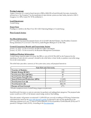
..D e Posting Language ..T itle Approve issuance of a capacity-based incentive (CBI) of $80,190 to Saint Edwards University, hereinafter referred to as “the Customer” for the installation of solar electric systems on their facility, located at 3001 S Congress Ave OPS, Austin TX 78704, in District 3. Lead Department Austin Energy Fiscal Note Funding is available in the Fiscal Year 2021-2022 Operating Budget of Austin Energy. Prior Council Action: For More Information: Jeff Vice, Director, Local Government Issues (512) 322-6087; Richard Génecé, Vice President, Customer Energy Solutions (512) 322-6327; Tim Harvey, Solar Program Manager (512) 482-5386. Council Committee, Boards and Commission Action: January 10, 2022 – To be reviewed by the Electric Utility Commission. January 18, 2022 – To be reviewed by the Resource Management Commission. Additional Backup Information: Austin Energy requests approval to issue this CBI at a rate of $1.00/Watt-DC to the Customer for the installation of solar electric system(s)*, detailed in the table below at their facility to produce renewable energy for on-site consumption. The table below provides a summary of the system sizes, costs, and proposed incentives: Saint Edwards University Number of Modules Module Rating (W-DC) Total System Size (kW-DC) Total System Size (kW-AC) Annual Estimated Production (kWh) Total System Cost ($) Total Incentive ($) Percent of Cost Covered 198 405 80 67 113,494 $119,197 $80,190 67% *All solar equipment meets Austin Energy program requirements Saint Edwards University is a private university for graduate and undergraduate programs. The proposed solar system would cover 40% of the historic annual energy needs of this building. This solar project will generate an estimated 113,494 kWh per year and, according to US Energy Information Administration, based on the state-wide electricity profile, is estimated to prevent the production of the following emissions each year: 53 tons of Carbon Dioxide (CO2); 68 pounds of Sulfur Dioxide (SO2); and 79 pounds of Nitrogen Oxide (NOX). According to the Environmental Protection Agency (EPA)’s Greenhouse Gas Equivalency Calculator, these emissions reductions are equivalent to planting 795 trees or 58.9 acres of forest in Austin's parks or the removal of 120,837 vehicle miles or 10.5 cars from Austin roadways. According to the updated Austin Energy Resource, Generation and Climate Protection Plan, approved by Austin City Council in March 2020, “Austin Energy will achieve a total of 375 MW of local solar capacity by the end of 2030, of which 200 MW will be customer-sited (when …
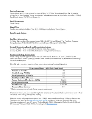
..De Posting Language ..Title Approve issuance of a capacity-based incentive (CBI) of $252,780 to Westminster Manor, Inc, hereinafter referred to as “the Customer” for the installation of solar electric systems on their facility, located at 4232 Bull Creek Road, Austin, TX 78731, in District 10. Lead Department Austin Energy Fiscal Note Funding is available in the Fiscal Year 2021-2022 Operating Budget of Austin Energy. Prior Council Action: For More Information: Jeff Vice, Director, Local Government Issues (512) 322-6087; Richard Génecé, Vice President, Customer Energy Solutions (512) 322-6327; Tim Harvey, Solar Program Manager (512) 482-5386. Council Committee, Boards and Commission Action: January 10, 2022 – To be reviewed by the Electric Utility Commission. January 18, 2022 – To be reviewed by the Resource Management Commission. Additional Backup Information: Austin Energy requests approval to issue this CBI at a rate of $1.00/Watt-DC to the Customer for the installation of solar electric system(s)*, detailed in the table below at their facility to produce renewable energy for on-site consumption. The table below provides a summary of the system sizes, costs, and proposed incentives: Westminster Manor – 4232 Bull Creek Road Number of Modules Module Rating (W-DC) Total System Size (kW-DC) Total System Size (kW-AC) Annual Estimated Production (kWh) Total System Cost ($) Total Incentive ($) Percent of Cost Covered 766 330 253 210 364,155 $492,921 $252,780 51% *All solar equipment meets Austin Energy program requirements Westminster Manor, Inc, is an assisted living facility for seniors. The proposed solar system would cover 12% of the historic annual energy needs of this building. This solar project will generate an estimated 364,155 kWh per year and, according to US Energy Information Administration, based on the state-wide electricity profile, is estimated to prevent the production of the following emissions each year: 171 tons of Carbon Dioxide (CO2); 218 pounds of Sulfur Dioxide (SO2); and 255 pounds of Nitrogen Oxide (NOX). According to the Environmental Protection Agency (EPA)’s Greenhouse Gas Equivalency Calculator, these emissions reductions are equivalent to planting 2,565 trees or 190 acres of forest in Austin's parks or the removal of 389,869 vehicle miles or 33.7 cars from Austin roadways. According to the updated Austin Energy Resource, Generation and Climate Protection Plan, approved by Austin City Council in March 2020, “Austin Energy will achieve a total of 375 MW of local solar capacity by the end of 2030, of which 200 MW will be customer-sited (when including …
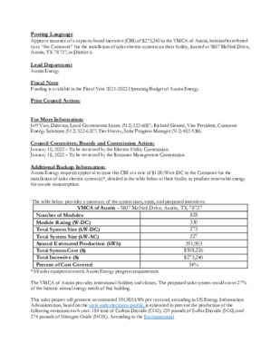
..De Posting Language ..Title Approve issuance of a capacity-based incentive (CBI) of $273,240 to the YMCA of Austin, hereinafter referred to as “the Customer” for the installation of solar electric systems on their facility, located at 5807 McNeil Drive, Austin, TX 78727, in District 6. Lead Department Austin Energy Fiscal Note Funding is available in the Fiscal Year 2021-2022 Operating Budget of Austin Energy. Prior Council Action: For More Information: Jeff Vice, Director, Local Government Issues (512) 322-6087; Richard Génecé, Vice President, Customer Energy Solutions (512) 322-6327; Tim Harvey, Solar Program Manager (512) 482-5386. Council Committee, Boards and Commission Action: January 10, 2022 – To be reviewed by the Electric Utility Commission. January 18, 2022 – To be reviewed by the Resource Management Commission. Additional Backup Information: Austin Energy requests approval to issue this CBI at a rate of $1.00/Watt-DC to the Customer for the installation of solar electric system(s)*, detailed in the table below at their facility to produce renewable energy for on-site consumption. The table below provides a summary of the system sizes, costs, and proposed incentives: YMCA of Austin - 5807 McNeil Drive, Austin, TX 78727 Number of Modules Module Rating (W-DC) Total System Size (kW-DC) Total System Size (kW-AC) Annual Estimated Production (kWh) Total System Cost ($) Total Incentive ($) Percent of Cost Covered 828 330 273 227 391,903 $508,226 $273,240 54% *All solar equipment meets Austin Energy program requirements The YMCA of Austin provides recreational facilities and classes. The proposed solar system would cover 27% of the historic annual energy needs of this building. This solar project will generate an estimated 391,903 kWh per year and, according to US Energy Information Administration, based on the state-wide electricity profile, is estimated to prevent the production of the following emissions each year: 184 tons of Carbon Dioxide (CO2); 235 pounds of Sulfur Dioxide (SO2); and 274 pounds of Nitrogen Oxide (NOX). According to the Environmental Protection Agency (EPA)’s Greenhouse Gas Equivalency Calculator, these emissions reductions are equivalent to planting 2,760 trees or 205 acres of forest in Austin's parks or the removal of 419,508 vehicle miles or 36.3 cars from Austin roadways. According to the updated Austin Energy Resource, Generation and Climate Protection Plan, approved by Austin City Council in March 2020, “Austin Energy will achieve a total of 375 MW of local solar capacity by the end of 2030, of which 200 MW will be customer-sited …
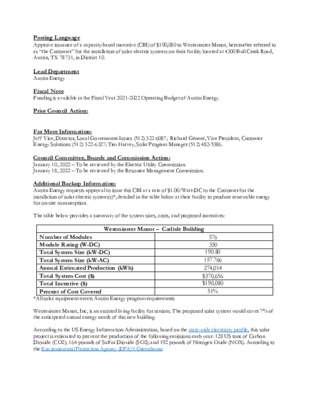
..D e Posting Language ..T itle Approve issuance of a capacity-based incentive (CBI) of $190,080 to Westminster Manor, hereinafter referred to as “the Customer” for the installation of solar electric systems on their facility located at 4300 Bull Creek Road, Austin, TX 78731, in District 10. Lead Department Austin Energy Fiscal Note Funding is available in the Fiscal Year 2021-2022 Operating Budget of Austin Energy. Prior Council Action: For More Information: Jeff Vice, Director, Local Government Issues (512) 322-6087; Richard Génecé, Vice President, Customer Energy Solutions (512) 322-6327; Tim Harvey, Solar Program Manager (512) 482-5386. Council Committee, Boards and Commission Action: January 10, 2022 – To be reviewed by the Electric Utility Commission. January 18, 2022 – To be reviewed by the Resource Management Commission. Additional Backup Information: Austin Energy requests approval to issue this CBI at a rate of $1.00/Watt-DC to the Customer for the installation of solar electric system(s)*, detailed in the table below at their facility to produce renewable energy for on-site consumption. The table below provides a summary of the system sizes, costs, and proposed incentives: Westminster Manor – Carlisle Building Number of Modules Module Rating (W-DC) Total System Size (kW-DC) Total System Size (kW-AC) Annual Estimated Production (kWh) Total System Cost ($) Total Incentive ($) Percent of Cost Covered 576 330 190.80 157.766 274,014 $370,656 $190,080 51% *All solar equipment meets Austin Energy program requirements Westminster Manor, Inc, is an assisted living facility for seniors. The proposed solar system would cover 7% of the anticipated annual energy needs of this new building. According to the US Energy Information Administration, based on the state-wide electricity profile, this solar project is estimated to prevent the production of the following emissions each year: 128 US tons of Carbon Dioxide (CO2); 164 pounds of Sulfur Dioxide (SO2); and 192 pounds of Nitrogen Oxide (NOX). According to the Environmental Protection Agency (EPA)’s Greenhouse Gas Equivalency Calculator, these emissions reductions are equivalent to planting 1,920 trees or 142 acres of forest in Austin's parks or the removal of 291,832 vehicle miles or 25.3 cars from Austin roadways. According to the updated Austin Energy Resource, Generation and Climate Protection Plan, approved by Austin City Council in March 2020, “Austin Energy will achieve a total of 375 MW of local solar capacity by the end of 2030, of which 200 MW will be customer-sited (when including both in-front-of-meter and behind-the meter installations).” In …
..D e Posting Language ..T itle Approve issuance of a capacity-based incentive (CBI) of $231,990 to the YMCA of Austin, hereinafter referred to as “the Customer” for the installation of solar electric systems on their facility, located at 5315 Ed Bluestein, Austin, TX 78724, in District 1. Lead Department Austin Energy Fiscal Note Funding is available in the Fiscal Year 2021-2022 Operating Budget of Austin Energy. Prior Council Action: For More Information: Jeff Vice, Director, Local Government Issues (512) 322-6087; Richard Génecé, Vice President, Customer Energy Solutions (512) 322-6327; Tim Harvey, Solar Program Manager (512) 482-5386. Council Committee, Boards and Commission Action: January 10, 2022 – To be reviewed by the Electric Utility Commission. January 18, 2022 – To be reviewed by the Resource Management Commission. Additional Backup Information: Austin Energy requests approval to issue this CBI at a rate of $1.00/Watt-DC to the Customer for the installation of solar electric system(s)*, detailed in the table below at their facility to produce renewable energy for on-site consumption. The table below provides a summary of the system sizes, costs, and proposed incentives: YMCA of Austin - 5315 Ed Bluestein, Austin, TX 78724 Number of Modules Module Rating (W-DC) Total System Size (kW-DC) Total System Size (kW-AC) Annual Estimated Production (kWh) Total System Cost ($) Total Incentive ($) Percent of Cost Covered 703 330 231.99 192.552 322,462 $429,182 $231,990 54% *All solar equipment meets Austin Energy program requirements The YMCA of Austin provides recreational facilities and classes. The proposed solar system would cover 64% of the historic annual energy needs of this building. According to US Energy Information Administration and based on the state-wide electricity profile, this solar project is estimated to prevent the production of the following emissions each year: 152 tons of Carbon Dioxide (CO2); 193 pounds of Sulfur Dioxide (SO2); and 226 pounds of Nitrogen Oxide (NOX). According to the Environmental Protection Agency (EPA)’s Greenhouse Gas Equivalency Calculator, these emissions reductions are equivalent to planting 2,280 trees or 169 acres of forest in Austin's parks or the removal of 346,550 vehicle miles or 30 cars from Austin roadways. According to the updated Austin Energy Resource, Generation and Climate Protection Plan, approved by Austin City Council in March 2020, “Austin Energy will achieve a total of 375 MW of local solar capacity by the end of 2030, of which 200 MW will be customer-sited (when including both in-front-of-meter and behind-the …
ZONING & PLATTING COMMISSION AGENDA Tuesday, January 18, 2022 The Zoning and Platting Commission will convene at 6:00 PM on Tuesday, January 18, 2022 at Austin City Hall, Council Chambers, Room 1001 301 W. Second Street, Austin, TX. Some members of the Zoning and Platting Commission may be participating by videoconference. The meeting may be viewed online at: http://www.austintexas.gov/page/watch-atxn-live Cesar Acosta Nadia Barrera-Ramirez – Chair Timothy Bray Ann Denkler – Parliamentarian Betsy Greenberg David King – Secretary Jolene Kiolbassa – Vice-Chair Hank Smith Carrie Thompson Roy Woody Scott Boone EXECUTIVE SESSION (No public discussion) The Zoning & Platting Commission will announce it will go into Executive Session, if necessary, pursuant to Chapter 551 of the Texas Government Code, to receive advice from Legal Counsel on matters specifically listed on this agenda. The commission may not conduct a closed meeting without the approval of the city attorney. Private Consultation with Attorney – Section 551.071 CITIZEN COMMUNICATION The first four (4) speakers signed up prior to the speaker registration deadline will each be allowed a three-minute allotment to address their concerns regarding items not posted on the agenda. A. APPROVAL OF MINUTES 1. Approval of minutes from January 4, 2022. Attorney: Steven Maddoux 512-974-6080 Commission Liaison: Andrew Rivera, 512-974-6508 B. PUBLIC HEARINGS 1. Rezoning: Location: Postponement Request: 2. Restrictive Covenant Termination: Location: C14-2019-0166 - Parmer Business Park, District 1 13000, 13100 and 13106 1/2 Harris Ridge Boulevard, Harris Branch Watershed Owner/Applicant: Karlin McCallen Pass, LLC (Matthew Schwab) Armbrust & Brown, PLLC (Richard T. Suttle) Agent: LI-PDA to LI-PDA, to change a condition of zoning Request: Staff Rec.: Pending Sherri Sirwaitis, 512-974-3057, sherri.sirwaitis@austintexas.gov Staff: Housing and Planning Department Postponement request to February 1, 2022 by Staff C14-2016-0124(RCT) - Parmer Business Park RCT, District 1 13000, 13100 and 13106 1/2 Harris Ridge Boulevard, Harris Branch Watershed Owner/Applicant: Karlin McCallen Pass, LLC (Matthew Schwab) Armbrust & Brown, PLLC (Richard T. Suttle) Agent: The applicant is requesting a termination of the restrictive covenant Request: conditions for this property. Pending Sherri Sirwaitis, 512-974-3057, sherri.sirwaitis@austintexas.gov Housing and Planning Department Postponement request to February 1, 2022 by Staff Staff Rec.: Staff: Postponement Request: 3. Zoning: Location: Owner/Applicant: Agent: Request: Staff Rec.: Staff: C14-2021-0186 - Howard Lane Residences, District 7 1208 East Howard Lane, Harris Branch Watershed 1208 Howard Lane, LLC (Saeed Minhas) Alice Glasco Consulting (Alice Glasco) I-RR to MF-4 Recommended Sherri Sirwaitis, 512-974-3057, sherri.sirwaitis@austintexas.gov Housing and Planning Department …
RESOURCE MANAGEMENT COMMISSION January 18, 2022 6:00 p.m. Austin Energy Headquarters; 1st Floor; Shudde Fath Conference Room 4815 Mueller Blvd, Austin, Texas 78723 (Note: Some members of the Resource Management Commission maybe participating by videoconference.) REVISED AGENDA Members: Jonathan Blackburn, Chair (District 8) Kaiba White, Vice Chair (District 2) Charlotte Davis (District 1) Sam Angoori (District 3) Shane Johnson (District 4) Tom “Smitty” Smith (District 5) Louis Stone (District 6) Kelly Davis (District 7) Dana Harmon (District 9) Rebecca Brenneman (District 10) Lisa Chavarria (Mayor) For more information, please visit: www.austintexas.gov/rmc CALL MEETING TO ORDER CITIZEN COMMUNICATION: GENERAL Speaker must be present and will be allowed up to three minutes to provide their comments. APPROVAL OF MINUTES 1. Approve minutes of the November 16, 2021 Meeting of the Resource Management Commission. NEW BUSINESS – CONSENT ( ) = Target Council Meeting Date; [ ] = RCA Type 2. (2/17) [ Austin Energy] Approve issuance of a capacity-based incentive (CBI) of $268,960 to the Mothers’ Milk Bank @ Austin, hereinafter referred to as “the Customer” for the installation of solar electric systems on their facility, located at 5925 Dillard Circle, Unit A, Austin TX 78752, in District 4. 3. (2/17) [ Austin Energy] Approve issuance of a capacity-based incentive (CBI) of $141,750 to the Michael & Susan Dell Foundation (MSDF), hereinafter referred to as “the Customer” for the installation of solar electric systems on their facility, located at 4417 Westlake Drive, Building B, Austin, TX 78746, in District 10. 4. (2/17) [ Austin Energy] Approve issuance of a capacity-based incentive (CBI) of $80,190 to Saint Edwards University, hereinafter referred to as “the Customer” for the installation of solar electric systems on their facility, located at 3001 S Congress Ave OPS, Austin TX 78704, in District 3. 5. (2/17) [ Austin Energy] Approve issuance of a capacity-based incentive (CBI) of $252,780 to Westminster Manor, Inc, hereinafter referred to as “the Customer” for the The City of Austin is committed to compliance with the American with Disabilities Act. Reasonable modifications and equal access to communications will be provided upon request. Meeting locations are planned with wheelchair access. If requiring Sign Language Interpreters or alternative formats, please give at least two days (48 hours) before the meeting date. TTY users route through Relay Texas at 711. For more information on the Resource Management Commission , please call Natasha Goodwin (512) 322-6505. installation of solar …
DRAFT RESOLUTION 1: New Chemical Avoidance Point System Whereas Americans spend as much as 90% of their time indoors; and Whereas many building materials are made of, or coated with, toxic chemicals, whose harm can be magnified in modern energy-efficient buildings with less ventilation; and Whereas many of these chemicals have dangerous qualities, as they can be carcinogenic, neurotoxic, developmental and reproductive toxins, asthmagens and respiratory sensitizers, endocrine disrupting chemicals, acutely toxic, and aquatically toxic; and Whereas since many of these more toxic building products are less expensive, people with less income are more likely to be adversely affected by exposure to them, including apartment tenants, and entry- level tract-home buyers; and Whereas Austin seeks to lead by example to persuade other local and state governments and programs around the country to avoid harmful chemicals in buildings; Then Be It Resolved that the Resource Management Commission of the City of Austin recommend to the Austin City Council that: Austin Energy Green Building should revise its Residential Single Family and Multifamily rating system to establish minimum prerequisites for chemical avoidance in buildings as a condition for participation. This will include avoidance of various materials when cost-effective alternatives are available for PVC, PFCs (the Teflon® chemical family), antimicrobials, and other toxic chemicals on the “Red List” chemicals listed by the International Living Future Institute. And Be It Further Resolved that a stakeholders process should be created to seek input from the greater community, including environmentalists, tenant advocates, professionals in the building industry, and interested members of the Resource Management Commission; and Be It Further Resolved that this enhanced building rating system be placed into action at the beginning of calendar year 2023. ===== DRAFT RESOLUTION 2: New Chemical Avoidance Point System Whereas Americans spend as much as 90% of their time indoors; and Whereas many building materials are made of, or coated with, toxic chemicals, whose harm can be magnified in modern energy-efficient buildings with less ventilation; and Whereas many of these chemicals have dangerous qualities, as they can be carcinogenic, neurotoxic, developmental and reproductive toxins, asthmagens and respiratory sensitizers, endocrine disrupting chemicals, acutely toxic, and aquatically toxic; and Whereas since many of these more toxic building products are less expensive, people with less income are more likely to be adversely affected by exposure to them, including apartment tenants, and entry- level tract-home buyers; and Whereas Austin seeks to lead by example …
Regular Meeting ZONING & PLATTING COMMISSION Tuesday, January 18, 2022 The Zoning & Platting Commission convened in a meeting on Tuesday, January 18, 2022 @ http://www.austintexas.gov/page/watch-atxn-live Chair Barrera-Ramirez called the Commission Meeting to order at 6:05 p.m. Commission Members in Attendance: Cesar Acosta Scott Boone Timothy Bray Ann Denkler – Parliamentarian Betsy Greenberg David King Jolene Kiolbassa – Vice-Chair Nadia Barrera-Ramirez – Chair Hank Smith Carrie Thompson Absent Roy Woody EXECUTIVE SESSION (No public discussion) The Zoning & Platting Commission will announce it will go into Executive Session, if necessary, pursuant to Chapter 551 of the Texas Government Code, to receive advice from Legal Counsel on matters specifically listed on this agenda. The Commission may not conduct a closed meeting without the approval of the city attorney. Private Consultation with Attorney – Section 551.071 CITIZEN COMMUNICATION The first four (4) speakers signed up prior to the speaker registration deadline will each be allowed a three-minute allotment to address their concerns regarding items not posted on the agenda. A. APPROVAL OF MINUTES 1. Approval of minutes from January 4, 2022 Motion to approve minutes from January 4, 2022 was approved on the consent agenda on the motion by Commissioner Smith, seconded by Commissioner Acosta on a vote of 10-0. Commissioner Woody absent. B. PUBLIC HEARINGS 1. Rezoning: Location: C14-2019-0166 - Parmer Business Park, District 1 13000, 13100 and 13106 1/2 Harris Ridge Boulevard, Harris Branch Watershed Karlin McCallen Pass, LLC (Matthew Schwab) Armbrust & Brown, PLLC (Richard T. Suttle) LI-PDA to LI-PDA, to change a condition of zoning Pending Sherri Sirwaitis, 512-974-3057, sherri.sirwaitis@austintexas.gov Housing and Planning Department Postponement request to February 1, 2022 by Staff Motion to grant Staff’s request for postponement of this item to February 1, 2022 was approved on the consent agenda on the motion by Commissioner Smith, seconded by Commissioner Acosta on a vote of 10-0. Commissioner Woody absent. 2. Restrictive C14-2016-0124(RCT) - Parmer Business Park RCT, District 1 13000, 13100 and 13106 1/2 Harris Ridge Boulevard, Harris Branch Watershed Karlin McCallen Pass, LLC (Matthew Schwab) Armbrust & Brown, PLLC (Richard T. Suttle) The applicant is requesting a termination of the restrictive covenant conditions for this property. Pending Sherri Sirwaitis, 512-974-3057, sherri.sirwaitis@austintexas.gov Housing and Planning Department Postponement request to February 1, 2022 by Staff Motion to grant Staff’s request for postponement of this item to February 1, 2022 was approved on the consent agenda on the motion …
Agenda Comprehensive Plan Joint Committee January 13, 2022 at 12:00 p.m. Street-Jones Building RM 400A 1000 E 11th St, Austin, TX 78702 Zoning and Platting Commission Cesar Acosta Timothy Bray Hank Smith COMMITTEE MEMBERS Planning Commission Grayson Cox Yvette Flores Carmen Llanes Pulido Robert Schneider CALL TO ORDER CITIZEN COMMUNICATION: GENERAL The first three speakers signed up prior to the meeting being called to order will each be allowed a three-minute allotment to address their concerns regarding items not posted on the agenda. 1. APPROVAL OF MINUTES 2. NEW BUSINESS 3. OLD BUSINESS a. Annual goal setting (Discussion and/or possible action) a. Industrial Study (Discussion and/or possible action) 4. FUTURE AGENDA ITEMS Future agenda items will NOT be discussed at the current meeting, but will be offered for initiation, discussion, and/or possible recommendation to the full Planning Commission at a FUTURE meeting. ADJOURNMENT The City of Austin is committed to compliance with the American with Disabilities Act. Reasonable modifications and equal access to communications will be provided upon request. Meeting locations are planned with wheelchair access. If requiring Sign Language Interpreters or alternative formats, please give notice at least 2 days before the meeting date. Please call Dee Dee Quinnelly at Housing and Planning Department, at 512-974-2036, for additional information; TTY users route through Relay Texas at 711. For more information on the Comprehensive Plan Joint Committee, please contact Dee Dee Quinnelly at 512-974- 2036 and DeeDee.Quinnelly@austintexas.gov
COMPREHENSIVE PLAN JOINT COMMITTEE Draft Minutes The Comprehensive Plan Joint Committee convened in a regular meeting on December 2, 2021 REGULAR MEETING December 2, 2021 at Street-Jones Building, 1000 East 11th Street, Room 400A, Austin, TX 78702. Timothy Bray Hank Smith The meeting was called to order at 12:12 p.m. Joint Committee Members in Attendance: Planning Commission Zoning and Platting Commission Grayson Cox Yvette Flores Robert Schneider City Staff in Attendance: Matt Dugan, Housing and Planning Department Dee Dee Quinnelly, Housing and Planning Department Others in Attendance: None. 1. CITIZEN COMMUNICATION: GENERAL None. 2. APPROVAL OF MINUTES A motion was made to approve the minutes from the June 11, 2021 meeting by Commissioner Schneider, seconded by Commissioner Smith. Vote 5-0. Commissioners Acosta and Llanes Pulido were absent. 3. NEW BUSINESS a. Orientation to Imagine Austin and the Role of the Comprehensive Plan Joint Committee (Discussion and/or possible action). Matt Dugan presented the Imagine Austin Comprehensive Plan to the Commissioners sharing background, key components and frameworks helpful to understand the plan. Dee Dee Quinnelly presented the Ordinance to create the Comprehensive Plan Joint Committee and the Committee’s bylaws to inform the conversation around the Role of the Committee. No action was taken. b. Approve for Adoption the Comprehensive Plan Joint Committee 2022 Calendar Year Meeting Schedule (Discussion and action). A motion to approve the 2022 Calendar Year CPJC Meeting schedule was made by Commissioner Schneider, seconded by Commissioner Cox. Vote 5-0. Commissioners Acosta and Llanes Pulido were absent. 1 4. OLD BUSINESS a. Vote to elect Vice-Chair (Discussion and/or possible action) A motion was made to elect Commissioner Smith as Vice-Chair by Commissioner Schneider, seconded by Chair Garcia. Vote 5-0. Commissioners Acosta and Llanes Pulido were absent. 5. FUTURE AGENDA ITEMS ADJOURNMENT The meeting adjourned at 1:00 p.m. The City of Austin is committed to compliance with the American with Disabilities Act. Reasonable modifications and equal access to communications will be provided upon request. Meeting locations are planned with wheelchair access. If requiring Sign Language Interpreters or alternative formats, please give notice at least 4 days before the meeting date. Please call Dee Dee Quinnelly at Planning and Zoning Department, at 512-974-2036, for additional information; TTY users route through Relay Texas at 711. For more information on the Comprehensive Plan Joint Committee, please contact Dee Dee Quinnelly at (512) 974-2036 or deedee.quinnelly@austintexas.gov. 2
ANALYSIS OF INDUSTRIAL LAND USE AND ZONING IN AUSTIN, TEXAS Comprehensive Plan Joint Committee Briefing October 14, 2021 Mark Walters Study Organization Workforce Considerations National Trends and Best Practices Current State of Austin’s Industrially-Zoned Land Industrial Cluster Typology for Austin , Texas Conclusions & Recommendations Maps and Case Studies 2 Current State of Austin’s Industrially-Zoned Land 11,657 Acres or 6.6% of Austin zoned for industrial (2018) Only 38% of Industrial zoned land used for industrial uses • Undeveloped 27% • Office 12% 3 Current State of Austin’s Industrially-Zoned Land Industrial zoned areas mostly located to take advantage of highways and ABIA 4 Current State of Austin’s Industrially-Zoned Land Between 2001 and 2018 1,846 acres rezoned from industrial to non-industrial zones Industrial zoned land lost through neighborhood plan rezonings was not included 5 Current State of Austin’s Industrially-Zoned Land Worth $9.5B or 6% of Austin’s value Higher Improvement-to-Land Ratio 2014-2018 tax assessments increased 52%/ commercial land increased 62% Most industrial zoned land gained through annexation North Burnet/Gateway lost over 1,000 acres of industrial zoned land (2008) 6 Industrial Cluster Typology for Austin Identified 8 industrial clusters within Austin Based on best practices from Las Angeles, CA and Philadelphia, PA staff developed an industrial cluster typology Protection Intensification Transition 7 Industrial Cluster Typology for Austin Protection Industrial zoning should be maintained and residential uses discouraged Intensification Can accommodate more industrial uses through zoning certainty, planned infrastructure improvements, and master planning to coordinate public and private investment Transition Areas experiencing significant land conversion to non-industrial uses and are no longer or increasingly less viable for industrial 8 Industrial Cluster Typology for Austin North Research Boulevard Intensification / Protection North Burnet/Gateway Transition Tech Ridge Intensification US-290 Intensification Near East Transition US-183 Transition St. Elmo Transition Ben White Intensification 9 Findings Annexations biggest driver in industrial land growth 37 acres of industrial zoning lost annually for the last ten years Neighborhood and Small Area Plans 10 Findings Recent development of corporate campuses and business/industrial parks Austin’s legacy industrial clusters undergoing transition (e.g., St. Elmo & NBG) Undeveloped industrial land along one-way freeway frontage roads targeted for garden-style apartments 11 Recommendations Precautions must be taken to ensure that nearby industrial properties do not pose a risk to future MF residents Redevelopment in Transition areas should provide sidewalks, bike lanes, storm water facilities, open space, etc. Existing long-term industrial uses should not be punished by new residents …
ANALYSIS OF INDUSTRIAL LAND USE AND ZONING IN AUSTIN, TEXAS Prepared by the City of Austin’s Planning and Zoning Department March, 2020* *Updated September 2020 with minor changes Table of Contents Introduction ............................................................................................................................................ 3 The Austin Context.................................................................................................................................. 4 Environmental Justice, Racial Segregation, and the 1928 City Plan ................................................. 4 Research and Development ............................................................................................................... 6 Annexation of Industrial Property ....................................................................................................... 7 National Trends and Best Practices in Sustainable Industrial Development ......................................... 7 San Francisco, California .................................................................................................................... 8 Philadelphia, Pennsylvania ................................................................................................................. 9 Los Angeles, California .................................................................................................................... 10 Portland, Oregon .............................................................................................................................. 12 Current State of Austin’s Industrial-Zoned Land ................................................................................. 13 Industrial Land Uses ........................................................................................................................ 16 Property Values................................................................................................................................ 17 Zoning Cases ................................................................................................................................... 17 The Imagine Austin Comprehensive Plan ........................................................................................ 20 Geographic Distribution & Transport ............................................................................................... 20 Vacancies and Undeveloped Land .................................................................................................. 20 Building and Annexation Over Time ................................................................................................. 20 Workforce Considerations ................................................................................................................... 21 Workforce Master Plan .................................................................................................................... 21 Job Totals for Austin’s Industrial-Zoned Land ................................................................................. 23 An Industrial Cluster Typology for Austin ............................................................................................. 24 Key Considerations .......................................................................................................................... 26 Conclusion ........................................................................................................................................... 28 Trends .............................................................................................................................................. 28 1 Recommendations .......................................................................................................................... 29 Appendix I: Maps ................................................................................................................................. 30 Base Zoning Districts ....................................................................................................................... 30 Industrial Clusters – Land Use ........................................................................................................ 31 Industrial Zoning District Cases ....................................................................................................... 32 Industrial Clusters - Loss of Industrial Zoning ................................................................................. 33 Imagine Austin Jobs Centers ........................................................................................................... 34 Freight Transport Network ............................................................................................................... 35 Developed & Vacant Industrial Zoning ............................................................................................ 36 Industrial-Zoned Properties Decade Annexed ................................................................................. 37 Industrial-Zoned Properties Year Structure Built ............................................................................. 38 2001 Zoning Layer with 2002 US Census Data .............................................................................. 39 2018 Zoning Layer with 2017 US Census Data .............................................................................. 40 Industrial Zoning Study: Case Study Area........................................................................................ 41 Appendix II: Industrial Cluster Case Studies ........................................................................................ 42 North Research Boulevard .............................................................................................................. 42 North Burnet/Gateway .................................................................................................................... 42 Tech Ridge ....................................................................................................................................... 44 US 290 East..................................................................................................................................... 45 Near East ......................................................................................................................................... 46 US 183............................................................................................................................................. 48 St Elmo ............................................................................................................................................ 50 Ben White ........................................................................................................................................ 54 2 Introduction Austin, like many growing cities across the country, is experiencing pressure to convert industrially used and zoned land to mixed-use commercial and residential redevelopment and development. Imagine Austin (2012), the City’s comprehensive plan, envisions “a city of complete communities…defined by amenities, transportation, services, and opportunities that fulfill all Austinites’ material, social, and economic needs.” One component of a complete community is employment opportunities for residents of all skill and education levels. In 2017 there were a total of 624,417 employees citywide. In the city’s industrial-zoned properties, there were 75,244 employees, representing 12% of the …
COMMISSION ON SENIORS JANUARY 12TH, 2022 AT 12:00PM AUSTIN CITY HALL, BOARDS AND COMMISSIONS ROOM 301 WEST 2ND STREET, AUSTIN, TEXAS, 78701 CURRENT BOARD MEMBERS: Janee Briesmeister, Chair Peter Varteressian, Vice-Chair Natalie Cagle Jacqueline Angel Martha Bauman Patricia Bordie Emily De Maria Nicola Erica Garcia-Pittman AGENDA Adam Hauser Martin Kareithi Luz Lopez-Guerrero Sally Van Sickle Fred Lugo Diana Spain Amy Temperley CALL TO ORDER CITIZEN COMMUNICATION Each speaker signed up prior to the meeting being called to order will be called in order of sign- up and will be allowed three minutes to speak about items posted or not on the agenda. 1. APPROVAL OF MINUTES FROM THE COMMISSION ON SENIORS NOVEMBER 10TH, 2021 AND DECEMBER 8TH, 2021 MEETNG 2. ANNOUCEMENTS 3. OLD BUSINESS A. Discussion and possible action Commission Work Plan – Standing Item B. Discussion and possible action from Working Groups – Standing Item i. Age Friendly Action Plan Implementation Working Group ii. iii. Transportation, Housing and Outdoor Spaces Working Group Social Participation, Respect and Social Inclusion, Civic Participation and Employment Working Group iv. Community Support and Health Services Working Group v. Emergency Preparedness and Response Working Group C. Discussion and possible action from Joint Inclusion Committee – Standing Item (Commissioner De Maria Nicola) D. Discussion and possible action of City of Austin Budget – Standing Item (Chair Briesmeister) 4. NEW BUSINESS Representative. A. Discussion and possible action on Commission on Seniors Joint Inclusion Committee B. Review and possible action on Commission on Seniors FY23 Budget Engagement Survey. C. Discussion and possible action on a resolution regarding cold weather shelters (Commissioner Temperley). D. Discussion on Community Engagement for FY23 Budget Process. A. Age-friendly Austin Update, Tabitha Taylor, Age-Friendly Program Coordinator. 5. STAFF BRIEFINGS 6. FUTURE AGENDA ITEMS 7. ADJOURNMENT The City of Austin is committed to compliance with the American with Disabilities Act. Reasonable modifications and equal access to communications will be provided upon request. Meeting locations are planned with wheelchair access. If requiring Sign Language Interpreters or alternative formats, please give notice at least 2 days (48 hours) before the meeting date. Please call Halana Kaleel at Austin Public Health Department, at 512-972-5019, for additional information; TTY users route through Relay Texas at 711. For more information on the Commission on Seniors please contact Halana Kaleel at 512-972- 5019.
EARLY CHILDHOOD COUNCIL January 12, 2022, 8:30 A.M. CITY HALL, BOARD AND COMMISSION ROOM #1101 301 WEST SECOND STREET, AUSTIN, TEXAS AGENDA CALL TO ORDER CITIZEN COMMUNICATION: GENERAL The first five speakers who register to speak no later than noon the day before the meeting will be allowed a three-minute allotment to address their concerns regarding items not posted on the agenda. 1. APPROVAL OF MINUTES from November 10, 2021, meeting 2. OLD BUSINESS a. Review and discuss Workforce Solutions Capital Area’s response to the ECC memo approved at the November 10, 2021, meeting 3. NEW BUSINESS AND POSSIBLE ACTIONS a. Policy Work Group proposed actions- Anna Lisa Conlin i. Resolution to ask the City to acknowledge the challenges and stress of child care service providers during the COVID-19 pandemic and to acknowledge the impactful contribution of the child care sector to the City’s economy ii. Discuss draft proclamation and ECC letter honoring Leonor Vargas and her contribution to early childhood education, children, families, and the public school system b. Joint Inclusion Committee updates- Raul Alvarez i. Appointment of 3 ECC members to attend the Joint Inclusion Committee budget meeting on January 29, 2022 c. Community Engagement Work Group updates ECC Budget Forum on February 19, 2022 i. ii. Community Advancement Network (CAN) Expanding Opportunity Forum on “Building a Family-Friendly Workplace” on February 9, 2022 d. Discuss ways ECC members can promote the Best Place for Working Parents campaign (January 10 - February 11, 2022) – Cathy McHorse 4. STAFF UPDATES a. COVID-19 updates b. KinderCare at Bergstrom Tech opening and enrollment updates FUTURE AGENDA ITEMS a. Update about Head Start from Child Inc b. Child care staffing shortage in Austin ADJOURNMENT The City of Austin is committed to compliance with the American with Disabilities Act. Reasonable modifications and equal access to communications will be provided upon request. Meeting locations are planned with wheelchair access. If requiring Sign Language Interpreters or alternative formats, please give notice at least 2 days (48 hours) before the meeting date. Please call Caitlin Oliver, Program Coordinator, Austin Public Health, at 512-972-6205 or email: Caitlin.Oliver@austintexas.gov, for additional information; TTY users route through Relay Texas at 711. For more information on the Early Childhood Council, please contact Caitlin Oliver, Program Coordinator, Austin Public Health, at 512-972-6205 or email: Caitlin.Oliver@austintexas.gov.
ZERO WASTE ADVISORY COMMISSION SPECIAL CALLED MEETING JANUARY 12TH, 2022 6:00 PM CITY HALL, AUSTIN, TX Some members of the ZERO WASTE ADVISORY COMMISSION may be participating by videoconference. The meeting may be viewed online at: http://www.austintexas.gov/page/watch-atxn-live CURRENT COMMISSION MEMBERS: Gerry Acuna Jonathan Barona Ian Steyaert AGENDA Cathy Gattuso Melissa Rothrock Albert Swantner Amanda Masino Kaiba White CITIZEN COMMUNICATION: GENERAL The first three speakers signed up prior to the meeting being called to order will each be allowed a three-minute allotment to address their concerns regarding items not posted on the agenda. 1. APPROVAL OF MINUTES: October 13th, 2021, Regular Meeting Minutes 2. NEW BUSINESS a) Discussion and Action: Truck Washing and Equipment Maintenance RCA-Victoria Rieger b) Discussion and Action: Capital Improvement Project for ARR- Andrew Clements c) Discussion and Action: 2022 ZWAC Meeting Schedule- Gerry Acuna d) Discussion and Action: ZWAC FY22 Board Vacancies- Gerry Acuna e) Discussion and Action: Proposal in ARR Wage Increases- Carina Hanson f) Discussion and Action: Trash/Water Wheel on Lady Bird Lake Update-Kaiba White 3. DIRECTOR’S REPORT 1. Solicitations Update, Performance Reports, Beyond 34 Update, Universal Recycling Ordinance (URO) Enforcement Update, URO Multifamily Update, Recycling Contract Processing Contracts Update FUTURE AGENDA ITEMS Small Minority Business Resources (SMBR) Future Opportunities and Involvement Keep Austin Beautiful Update Future FM 812 Landfill Potential 2022 Annual ZWAC Retreat ADJOURNMENT The City of Austin is committed to compliance with the American with Disabilities Act. Reasonable modifications and equal access to communications will be provided upon request. Meeting locations are planned with wheelchair access. If requiring Sign Language Interpreters or alternative formats, please give notice at least 2 days (48 hours) before the meeting date. Please call Dwight Scales at Austin Resource Recovery Department, at (512)974-2435 for additional information; TTY users’ route through Relay Texas at 711. For more information on the Zero Waste Advisory Commission, please contact Dwight Scales at (512)974-2435.
To: From: Date: Subject: Zero Waste Advisory Commission Ken Snipes Director Austin Resource Recovery January 12, 2022 Director’s Monthly Report to the Zero Waste Advisory Commission Universal Recycling Ordinance (URO) Enforcement Update: The Austin Resource Recovery (ARR) Commercial Compliance Unit (CCU) is comprised of 2 Code Compliance Officers who contact responsible parties and conduct site visits to properties or permit holders identified by City staff or by complaints as non-compliant with ordinances. The goal of the CCU is to support ongoing department public education, and when necessary, hold non-compliant businesses and permit holders accountable in municipal court. 9 The department hired its first CCU staff in 2020 and spent much of the past year creating internal procedures, developing a software system, and contacting potentially non-compliant properties. Prior to 2020, the City had limited opportunity to provide onsite visits from Code Compliance Officers and was reliant upon education alone to seek compliance. CCU began URO inspections in early FY21. As of December 2021, CCU has conducted 742 site visits, responded to 5 complaints, and followed up on 86 denied waivers. Universal Recycling Ordinance (URO) Multifamily Update: In FY21, ARR’s Business Outreach Team (BOT) notified all multifamily properties of the URO’s capacity increase by mail and email in Oct. 2020 and again in June 2021. The BOT also took out print and digital ads March 2020 (FY20) through Dec. 2020 and hosted a joint webinar with Austin Apartments Association (AAA) in Nov. 2020. In terms of compliance, 86% of multifamily properties (1,208) reported meeting the new capacity requirements by either providing at least a 1:1 ratio of landfill trash to recycling/organics services or 24 gallons/unit/week of recycling/organics services. Of the 14% of multifamily properties (201) that requested a waiver for not meeting the new capacity requirements, 13% (181 properties) were above the previous 6.4 gallons/unit/week requirement, but below the new 24 gallons/unit/week increase. Only 1% (20 properties) reported being below the 50% diversion requirement and of 6.4 gallons/unit/week. The BOT contacted all multifamily properties that requested a waiver for being below the new 24 gallons/unit/week requirement to let them know of the new capacity requirements and approved waivers with more than 6.4 gallons/unit/week according to the “implementation year” prescribed by the administrative rules (Administrative Rules Chapter 15-5 Section 8.12.3), but denied waivers below 6.4 gallons/unit/week. So far in FY22, a third of multifamily properties (554) that have reported and 92% (509) have …