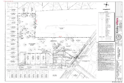
LOT 13 BLOCK 4 OLT 21 DIV B CHERNOSKY NO 9 ZONING: SF-3-NP USE: SINGLE-FAMILY LOT 12 BLOCK 4 OLT 21 DIV B CHERNOSKY NO 9 ZONING: SF-3-NP USE: SINGLE-FAMILY LOT 11 BLOCK 4 OLT 21 DIV B CHERNOSKY NO 9 ZONING: SF-3-NP USE: SINGLE-FAMILY ' 2 2 . 9 7 ' W " 4 2 6 5 ° 0 1 N LOT 10 BLOCK 4 OLT 21 DIV B CHERNOSKY NO 9 ZONING: SF-3-NP USE: SINGLE-FAMILY LOT 9 BLOCK 4 OLT 21 DIV B CHERNOSKY NO 9 ZONING: SF-3-NP USE: SINGLE-FAMILY LOT 8 BLOCK 4 OLT 21 DIV B CHERNOSKY NO 9 ZONING: SF-3-NP USE: SINGLE-FAMILY LOT 7 BLOCK 4 OLT 21 DIV B CHERNOSKY NO 9 ZONING: SF-3-NP USE: SINGLE-FAMILY LOT 6 BLOCK 4 OLT 21 DIV B CHERNOSKY NO 9 ZONING: SF-3-NP USE: SINGLE-FAMILY LOT 5 BLOCK 4 OLT 21 DIV B CHERNOSKY NO 9 ZONING: SF-3-NP USE: SINGLE-FAMILY ' 3 9 . 4 0 5 ' W " 2 0 6 0 ° 1 1 N LOT 4 BLOCK 4 OLT 21 DIV B CHERNOSKY NO 9 ZONING: SF-3-NP USE: SINGLE-FAMILY LOT 3 BLOCK 4 OLT 21 DIV B CHERNOSKY NO 9 ZONING: SF-3-NP USE: SINGLE-FAMILY LOT 2 BLOCK 4 OLT 21 DIV B CHERNOSKY NO 9 ZONING: SF-3-NP USE: SINGLE-FAMILY LOT 1 BLOCK 4 OLT 21 DIV B CHERNOSKY NO 9 ZONING: SF-6-NP USE: UNDEVELOPED TBM#1 2 3 T O L Y O N R U O L F B V D 2 / 1 8 1 T L O I 3 C E S S T H G E H I P N - 3 - F S : I G N N O Z Y L I M A F - E L G N S I : E S U N78°55'38"E 204.88' 1 3 T O L Y O N R U O L F B V D 2 / 1 8 1 T L O I 3 C E S S T H G E H I P N - 3 - F S : I G N N O Z Y L I M A F - E L G N S I : E S U ' 8 6 . 9 7 2 ' E " 8 5 5 0 ° 9 S 6.25 AC OF OLT 18&1/2 DIVISION B BETHANY CEMETERY ZONING: P-NP USE: CEMETERY N79°21'15"E 206.81' N79°21'15"E …
06 C14H-2025-0117 - Bethany Cemetery; District 11 of 28 From: To: Subject: Date: Contreras, Kalan Bethany Cemetery Monday, February 9, 2026 3:42:35 PM [You don't often get email from https://aka.ms/LearnAboutSenderIdentification ] Learn why this is important at External Email - Exercise Caution Hello Mr. Contreras, I am writing to express my full support for the historic zoning request for Bethany Cemetery (C14H-2025-0117) on the February 10, 2026 Planning Commission agenda. Bethany Cemetery is a historically significant Black cemetery that holds deep cultural, family, and community importance. Protecting this site helps preserve the history, legacy, and dignity of those buried there and ensures future generations can honor and remember them. I respectfully urge the Planning Commission to support granting historic zoning protections for Bethany Cemetery. Thank you for your time and consideration. Sincerely, DeNae Robbins Round Rock, Texas CAUTION: This is an EXTERNAL email. Please use caution when clicking links or opening attachments. If you believe this to be a malicious or phishing email, please report it using the "Report Message" button in Outlook. For any additional questions or concerns, contact CSIRT at "cybersecurity@austintexas.gov". 06 C14H-2025-0117 - Bethany Cemetery; District 13 of 28 06 C14H-2025-0117 - Bethany Cemetery; District 14 of 28 06 C14H-2025-0117 - Bethany Cemetery; District 15 of 28 06 C14H-2025-0117 - Bethany Cemetery; District 16 of 28 06 C14H-2025-0117 - Bethany Cemetery; District 17 of 28 06 C14H-2025-0117 - Bethany Cemetery; District 18 of 28 06 C14H-2025-0117 - Bethany Cemetery; District 19 of 28 06 C14H-2025-0117 - Bethany Cemetery; District 111 of 28 06 C14H-2025-0117 - Bethany Cemetery; District 112 of 28 06 C14H-2025-0117 - Bethany Cemetery; District 113 of 28 06 C14H-2025-0117 - Bethany Cemetery; District 114 of 28 06 C14H-2025-0117 - Bethany Cemetery; District 115 of 28 06 C14H-2025-0117 - Bethany Cemetery; District 116 of 28 06 C14H-2025-0117 - Bethany Cemetery; District 117 of 28 06 C14H-2025-0117 - Bethany Cemetery; District 118 of 28 06 C14H-2025-0117 - Bethany Cemetery; District 119 of 28 06 C14H-2025-0117 - Bethany Cemetery; District 120 of 28 06 C14H-2025-0117 - Bethany Cemetery; District 121 of 28 06 C14H-2025-0117 - Bethany Cemetery; District 122 of 28 06 C14H-2025-0117 - Bethany Cemetery; District 123 of 28 06 C14H-2025-0117 - Bethany Cemetery; District 126 of 28 06 C14H-2025-0117 - Bethany Cemetery; District 127 of 28 06 C14H-2025-0117 - Bethany Cemetery; District 128 of 28
February 8, 2026 From: 04 Flats Condominium Homeowner Association (1401 Eva St) To: Cynthia Hadri, Austin Planning CC: Richardo Silini and Kathy Brocato – 04 Lofts Board, Leah Bojo Dear Cynthia The 04 Flats Condominium Homeowners Association: C14-2025-0106 Austin Planning Commission, Since our postponement of the January 13, 2026 Planning Commission Meeting we have been in constructive dialog with the applicant (the Drenner Group) and believe we are aligned with the most important changes they need in the Conditional Overlay to complete their project. Below are our views on each provision. Part 3 A. Currently the proposal is to strike all language regarding traffic. The surrounding streets already experience substantial congestion and limited parking availability. The proposed uses would markedly increase vehicular tra(cid:431)ic, delivery activity, and visitor parking demand, exacerbating an already strained situation. This would likely result in spillover parking into residential areas and reduced access for existing residents. Gibson Street is only 600 feet (approximately) from South Congress to Newton and then dead ends into the School for the Deaf. We do not have a specific request on how many trips are reasonable, but no restriction seems insu(cid:431)icient. Part 3 B. The applicant stated that the current building is out of compliance and exceeds 20,000 sq ft. We do not have an objection to the current building, and we are happy to agree that the limitation should be expanded to match the existing building. We were told by the applicant no new structures that would add square footage would be added. If their plans di(cid:431)er then we would like to be informed. Part 3 C. We are fine with all deleted limitations except we were told that outdoor entertainment would be subject to additional permitting. Outdoor Entertainment as permitted uses is particularly troubling given the site’s proximity to homes. These uses would introduce persistent noise, amplified sound, and late-night activity, substantially diminishing residents’ quality of life and enjoyment of their homes. We would like the commission to consider noise restrictions. In addition, we were told that the restaurant provision needs to be struck since the applicant would like to serve food at business functions and that it would not be a full-scale restaurant. If that is indeed the case, we have no objections. 07 C14-2025-0106 - 108 W Gibson; District 91 of 2 Part 3 D a. Building Coverage - Our understanding is the building will not be …
08 C14-2025-0108 - Lightsey Homes; District 51 of 3 08 C14-2025-0108 - Lightsey Homes; District 52 of 3 08 C14-2025-0108 - Lightsey Homes; District 53 of 3
08 C14-2025-0108 - Lightsey Homes; District 51 of 7 08 C14-2025-0108 - Lightsey Homes; District 52 of 7 08 C14-2025-0108 - Lightsey Homes; District 53 of 7 08 C14-2025-0108 - Lightsey Homes; District 54 of 7 08 C14-2025-0108 - Lightsey Homes; District 55 of 7 08 C14-2025-0108 - Lightsey Homes; District 56 of 7 08 C14-2025-0108 - Lightsey Homes; District 57 of 7
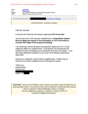
From: To: Subject: Date: Steve Nied Estrada, Nancy 1012 Concordia Saturday, February 7, 2026 7:25:48 PM [You don't often get email from https://aka.ms/LearnAboutSenderIdentification ] . Learn why this is important at External Email - Exercise Caution Dear Ms. Estrada, I am writing to urge the Planning Commission to recommend denial of the request of the developers of 1012 Concordia to increase the height of the proposed building. The requested height is extreme and does not at all fit with the character of the area. As a resident of the Hancock neighborhood, I would be personally affected by the increase in congestion from the already congested roadways in the area. The infrastructure is just not sufficient to support such density. Regards, Steve Nied Austin, TX CAUTION: This is an EXTERNAL email. Please use caution when clicking links or opening attachments. If you believe this to be a malicious or phishing email, please report it using the "Report Message" button in Outlook. For any additional questions or concerns, contact CSIRT at "cybersecurity@austintexas.gov". 09 C814-06-0175.07 - East Avenue PUD Amendment #7, Parcel A; District 92 of 2
09 C814-06-0175.07 - East Avenue PUD Amendment #7, Parcel A; District 91 of 2 From: To: Subject: Date: Maryanna Dickens Estrada, Nancy Re: Restrict height of bldgs on old Concordia Property. Tuesday, February 10, 2026 12:24:16 PM [You don't often get email from https://aka.ms/LearnAboutSenderIdentification ] . Learn why this is important at External Email - Exercise Caution Sent from my iPhone > On Feb 10, 2026, at 12:21 PM, Maryanna Dickens <maryannarosedickens@gmail.com> wrote: > Yes please restrict immediately!!! For helicopters also!!! Now!!! M. R. Dickens!!! Carolyn Ave!!!! > . CAUTION: This is an EXTERNAL email. Please use caution when clicking links or opening attachments. If you believe this to be a malicious or phishing email, please report it using the "Report Message" button in Outlook. For any additional questions or concerns, contact CSIRT at "cybersecurity@austintexas.gov". 09 C814-06-0175.07 - East Avenue PUD Amendment #7, Parcel A; District 92 of 2
PLANNING COMMISSION MEETING MINUTES Tuesday, February 10, 2026 PLANNING COMMISSION MEETING MINUTES REGULAR MEETING TUESDAY, FEBRUARY 10, 2026 The Planning Commission convened in a regular on Tuesday, February 10, 2026, at Austin City Hall, Council Chambers, Room 1001, 301 W. Second Street, in Austin, Texas. Chair Woods called the Planning Commission Meeting to order at 6:01 p.m. Commissioners in Attendance: Alice Woods Casey Haney Felicity Maxwell Imad Ahmed Chris Gannon Nadia Barrera-Ramirez Brian Bedrosian Peter Breton Danielle Skidmore Joshua Hiller Commissioners in Attendance Remotely: Adam Powell Commissioners Absent: Anna Lan Ex-Officio Members in Absent: TC Broadnax Jessica Cohen Candace Hunter Richard Mendoza 1 Vacancy on the Dais 1 PLANNING COMMISSION MEETING MINUTES Tuesday, February 10, 2026 PUBLIC COMMUNICATION: GENERAL Philip Wiley – Mobility Oriented Development APPROVAL OF MINUTES 1. Approve the minutes of the Planning Commission regular meeting on Tuesday, January 27, 2026. The motion to postpone the meeting minutes of Tuesday, January 27, 2026, to March 10, 2026, was approved on the consent agenda on Secretary Maxwell’s motion, Commissioner Bedrosian’s second, on an 11-0 vote. Commissioner Lan was absent. PUBLIC HEARINGS 2. Plan Amendment: NPA-2025-0031.01 - 8701 N Mopac Multifamily; District 10 Location: 8701 North Mopac Expressway Service Road NB, North Shoal Creek Neighborhood Planning Area; Shoal Creek Watershed Owner/Applicant: Mopac Atrium Investments, LLC, a Texas limited liability company Agent: Request: Staff Rec.: Staff: Dubois Bryant & Campbell, LLP (David Hartman) Commerce to Mixed-Use Activity HUB/Corridor Applicant postponement request to March 10, 2026 Maureen Meredith, 512-974-2695, maureen.meredith@austintexas.gov Austin Planning The motion to approve the Applicant’s postponement request to March 10, 2026, was approved on the consent agenda on Secretary Maxwell’s motion, Commissioner Bedrosian’s second, on an 11-0 vote. Commissioner Lan was absent. 3. Rezoning: Location: C14-2025-0088 - 8701 N Mopac Multifamily; District 10 8701 North Mopac Expressway Service Road NB, North Shoal Creek Neighborhood Planning Area; Shoal Creek Watershed Owner/Applicant: Mopac Atrium Investments, LLC Agent: Request: Staff Rec.: Staff: Dubois Bryant & Campbell, LLP (David Hartman) CS to LI-PDA Applicant postponement request to March 10, 2026 Sherri Sirwaitis, 512-974-3057, sherri.sirwaitis@austintexas.gov Austin Planning The motion to approve the Applicant’s postponement request to March 10, 2026, was approved on the consent agenda on Secretary Maxwell’s motion, Commissioner Bedrosian’s second, on an 11-0 vote. Commissioner Lan was absent. 2 PLANNING COMMISSION MEETING MINUTES Tuesday, February 10, 2026 4. Plan Amendment: NPA-2024-0018.01 - 7003, 7005, 7007 Guadalupe Street Rezone; District 4 Location: 7003, …
REGULAR MEETING OF THE IMPACT FEE ADVISORY COMMITTEE TUESDAY, FEBRUARY 10, 2026, AT 4:30 P.M. PERMITTING AND DEVELOPMENT CENTER, ROOM 1401 6310 WILHELMINA DECLO DRIVE AUSTIN, TEXAS Some members of the Impact Fee Advisory Committee may be participating by videoconference. Public comment will be allowed in-person or remotely via telephone. Speakers may only register to speak on an item once either in-person or remotely and will be allowed up to three minutes to provide their comments. Registration no later than noon the day before the meeting is required for remote participation by telephone. To register to speak remotely, contact Tyler Farrar at (512) 974-7050, Tyler.Farrar@austintexas.gov. CURRENT COMMITTEE MEMBERS: Bobak Tehrany, Chair Saba Hatami Harrison Hudson, Vice Chair Susan Turrieta Brian Grace Andrew Urban AGENDA CALL TO ORDER PUBLIC COMMUNICATION: GENERAL The first three speakers signed up prior to the meeting being called to order will each be allowed a three-minute allotment to address their concerns regarding items not posted on the agenda. APPROVAL OF MINUTES 1. Approve the minutes of the Impact Fee Advisory Committee special called meeting on December 2, 2025, regular meeting on August 12, 2025, regular meeting on May 13, 2025, and special called meeting on April 15, 2025. DISCUSSION ITEMS 2. Discussion and input on potential revisions to the Street Impact Fee (SIF) Ordinance and Code from IFAC members. DISCUSSION AND ACTION ITEMS FUTURE AGENDA ITEMS ADJOURNMENT The City of Austin is committed to compliance with the Americans with Disabilities Act. Reasonable modifications and equal access to communications will be provided upon request. For assistance, please contact the Liaison or TTY users’ route through 711. A person may request language access accommodations no later than 48 hours before the scheduled meeting. Please call or email Tyler Farrar at Austin Transportation and Public Works at (512) 974-7050 or Tyler.Farrar@austintexas.gov to request service or for additional information. For more information on the Impact Fee Advisory Committee, please contact Tyler Farrar at 512) 974- 7050 or Tyler.Farrar@austintexas.gov.
IMPACT FEE ADVISORY COMMITTEE MEETING MINUTES Tuesday, April 15, 2025 IMPACT FEE ADVISORY COMMITTEE REGULAR MEETING MINUTES Tuesday, April 15, 2025 The Impact Fee Advisory Committee convened in a Special Called meeting on Tuesday, April 15, 2025, at 6310 Wilhelmina Delco Drive in Austin, Texas. Chair Bobak Tehrany called the Impact Fee Advisory Committee Meeting to order at 4:33 p.m. Board Members in Attendance: Chair Bobak Tehrany, Saba Hatami, Andrew Urban Board Members in Attendance Remotely: Harrison Hudson, Susan Turrieta PUBLIC COMMUNICATION: GENERAL None present. APPROVAL OF MINUTES 1. Approve the minutes of the Impact Fee Advisory Committee Special Called Meeting on March 24, 2025. The minutes from the Impact Fee Advisory Committee Regular Meeting on March 24, 2025, were approved on Board Member Hatami’s motion, Board Member Turrieta’s second on a 5-0 vote. DISCUSSION AND ACTION ITEMS 2. Discussion and possible action on proposed changes to the transportation Capital Improvement Plan (CIP) and Land Use Assumption (LUA) as part of the 2025 Street Impact Fee study update. The presentation was made by Nathan Aubert, P.E., Supervising Engineer, ATPW and Jeff Whitacre, Kimley-Horn and the item was discussed. No action taken. FUTURE AGENDA ITEMS 1. 2. 3. Timing of Building Permits pulled, and collection rate applied Developer incentives to construct more infrastructure Officer votes 1 IMPACT FEE ADVISORY COMMITTEE MEETING MINUTES Tuesday, April 15, 2025 Board Member Tehrany adjourned the meeting at 5:09 p.m. without objection. 2
IMPACT FEE ADVISORY COMMITTEE MEETING MINUTES Tuesday, May 13, 2025 IMPACT FEE ADVISORY COMMITTEE REGULAR MEETING MINUTES TUESDAY, May 13, 2025 The Impact Fee Advisory Committee convened in a Regular meeting on Tuesday, May 13, 2025, at 6310 Wilhelmina Delco Drive in Austin, Texas. Chair Bobak Tehrany called the Impact Fee Advisory Committee Meeting to order at 4:32 p.m. Board Members in Attendance: Bobak Tehrany (Chair) Board Members in Attendance Remotely: Susan Turrieta (Vice Chair), Saba Hatami, Harrison Hudson, Andrew Urban PUBLIC COMMUNICATION: GENERAL None present. APPROVAL OF MINUTES 1. Approve the minutes of the Impact Fee Advisory Committee Regular Meeting on April 14, 2025. This item was postponed. DISCUSSION AND ACTION ITEMS 2. 3. Conduct officer elections for the Chair and Vice Chair. The motion to approve Board Member Bobak Tehrany as Chair (self-nominated) was approved on Chair Tehrany’s motion, Board member Hatami’s second on a 5-0 vote. The motion to approve Board Member Harrison Hudson as Vice Chair (nominated by Board Member Tehrany) was approved on Board Member Tehrany’s motion, Board Member Turrieta’s second on a 5-0 vote. Discussion and possible action on the water and wastewater Semi-Annual Impact Fee Report for October 1, 2024, through March 31, 2025, as set forth in the functions of the advisory committee, Austin City Code and Chapter 395.058 of the Texas Local Government Code. The motion to approve the Austin Water Semi-Annual Impact Fee Report for October 1, 2024, through March 31, 2025, was approved on Board Member Urban’s motion, Board Member Turrieta’s second on a 5-0 vote. 1 IMPACT FEE ADVISORY COMMITTEE MEETING MINUTES Tuesday, May 13, 2025 4. Discussion and possible action on the transportation and public works Semi-Annual Impact Fee Report for October 1, 2024, through March 31, 2025, as set forth in the functions of the advisory committee, Austin City Code and Chapter 395.058 of the Texas Local Government Code. The motion to approve the Austin Transportation and Public Works Semi-Annual Impact Fee Report for October 1, 2024, through March 31, 2025, was approved on Board Member Hatami’s motion, Board Member Harrison’s second on a 5-0 vote. FUTURE AGENDA ITEMS Chair Tehrany adjourned the meeting at 5:32 p.m. without objection. 2
IMPACT FEE ADVISORY COMMITTEE MEETING MINUTES Tuesday, August 12, 2025 IMPACT FEE ADVISORY COMMITTEE REGULAR MEETING MINUTES TUESDAY, August 12, 2025 The Impact Fee Advisory Committee convened in a Regular meeting on Tuesday, August 12, 2025, at 6310 Wilhelmina Delco Drive in Austin, Texas. Vice Chair Susan Turrieta called the Impact Fee Advisory Committee Meeting to order at 4:34 p.m. Board Members in Attendance: Andrew Urban, Harrison Hudson Board Members in Attendance Remotely: Brian Grace, Saba Hatami PUBLIC COMMUNICATION: GENERAL None present. APPROVAL OF MINUTES 1. Approve the minutes of the Impact Fee Advisory Committee Regular Meeting on May 13, 2025. This item was postponed. DISCUSSION AND ACTION ITEMS 2. Staff presentation on the recent state legislative session, highlighting new laws that directly impact the ongoing Street Impact Fee study update. The presentation was made by Nathan Aubert, P.E., Supervising Engineer, ATPW. No action taken. FUTURE AGENDA ITEMS 1. 2. Biannual updates from ATPW and AWU Presentation on Street Impact Fee maximum Vice Chair Turrieta adjourned the meeting at 4:58 p.m. without objection. 1
IMPACT FEE ADVISORY COMMITTEE MEETING MINUTES Tuesday, December 2, 2025 IMPACT FEE ADVISORY COMMITTEE REGULAR MEETING MINUTES TUESDAY, DECEMBER 2, 2025 The Impact Fee Advisory Committee convened in a Regular meeting on Tuesday, December 2, 2025, at 6310 Wilhelmina Delco Drive in Austin, Texas. Chair Bobak Tehrany called the Impact Fee Advisory Committee Meeting to order at 4:38 p.m. Board Members in Attendance: Bobak Tehrany (Chair), Brian Grace, Saba Hatami Board Members in Attendance Remotely: Susan Turrieta (Vice Chair), Andrew Urban PUBLIC COMMUNICATION: GENERAL None present. APPROVAL OF MINUTES 1. Approve the minutes of the Impact Fee Advisory Committee Regular Meeting on August 12, 2025. This item was postponed. DISCUSSION ITEMS 2. Presentation by consultant, Kimley-Horn, regarding peer cities case study analysis. The presentation was made by Ben Plett, P.E., PTOE, Kimley-Horn. Discussion regarding peer cities street impact fees and collection rates. Discussed. DISCUSSION AND ACTION ITEMS 3. Discussion and possible action on the water and wastewater Semi-Annual Impact Fee Report for April 1, 2024, through September 30, 2025, as set forth in the functions of the advisory committee, Austin City Code and Chapter 395.058 of the Texas Local Government Code. The motion to approve the Austin Water Semi-Annual Impact Fee Report for April 1, 2025, through September 30, 2025 was approved on Board Member Grace’s motion, Board Member Turrieta’s second on a 5-0 vote. Board Member Hudson and Board Member Rios were absent. 1 IMPACT FEE ADVISORY COMMITTEE MEETING MINUTES Tuesday, December 2, 2025 4. 5. Discussion and possible action on the transportation and public works Semi-Annual Impact Fee Report for April 1, 2025, through September 30, 2025, as set forth in the functions of the advisory committee, Austin City Code and Chapter 395.058 of the Texas Local Government Code. The motion to approve the Austin Transportation and Public Works Semi-Annual Impact Fee Report for April 1, 2025, through September 30, 2025 was approved on Board Member Hatami’s motion, Board Member Turrieta’s second on a 5-0 vote. Board Member Hudson and Board Member Rios were absent. Approve the 2026 annual schedule of the Impact Fee Advisory Committee. The motion to approve the 2026 annual schedule was approved on Board Member Turrieta’s motion, Board Member Hatami’s second on a 5-0 vote. Board Member Hudson and Board Member Rios were absent. FUTURE AGENDA ITEMS Chair Tehrany adjourned the meeting at 6:02 p.m. without objection. 2
REGULAR MEETING OF THE HISTORIC LANDMARK COMMISSION PRESERVATION PLAN COMMITTEE Tuesday, February 10, 2026, at 4 p.m. Permitting and Development Center, Room 1203 6310 Wilhelmina Delco Drive AUSTIN, TEXAS Some members of the committee may be participating by videoconference. Public comment will be allowed in-person or remotely via telephone. Speakers may only register to speak on an item once either in person or remotely and will be allowed up to three minutes to provide their comments. Registration no later than noon the day before the meeting is required for remote participation by telephone. To register to speak remotely, contact Cara Bertron at (512) 974-1446 or cara.bertron@austintexas.gov. CURRENT COMMISSIONERS Carl Larosche, Chair Roxanne Evans CALL TO ORDER PUBLIC COMMUNICATION: GENERAL Bat Taniguchi AGENDA The first 10 speakers signed up prior to the meeting being called to order or, for remote participation, no later than noon the day before the meeting, will each be allowed a three-minute allotment to address their concerns regarding items not posted on the agenda. APPROVAL OF MINUTES 1. Approve the minutes of the Preservation Plan Committee regular meeting on November 12, 2025. STAFF BRIEFINGS 2. Staff briefing regarding implementation of the Equity-Based Preservation Plan. Presentation by Cara Bertron, Program Manager II, Austin Planning, and Annie Flom, Senior Planner, Austin Planning. DISCUSSION ITEMS 3. 4. 5. Preservation Plan Summit debrief. Discussion of Historic Preservation Office annual report. Committee meeting schedule for 2026. FUTURE AGENDA ITEMS ADJOURNMENT The City of Austin is committed to compliance with the Americans with Disabilities Act. Reasonable modifications and equal access to communications will be provided upon request. For assistance, please contact the Liaison or TTY users’ route through 711. A person may request language access accommodations no later than 48 hours before the scheduled meeting. Please call or email Cara Bertron at Austin Planning at (512) 974-1446 or cara.bertron@austintexas.gov to request service or for additional information. For more information on the Preservation Plan Committee, please contact Cara Bertron at (512) 974- 1446 or cara.bertron@austintexas.gov.
REGULAR MEETING OF THE HISTORIC LANDMARK COMMISSION PRESERVATION PLAN COMMITTEE Tuesday, February 10, 2026, at 4 p.m. Permitting and Development Center, Room 1203 6310 Wilhelmina Delco Drive AUSTIN, TEXAS Some members of the committee may be participating by videoconference. Public comment will be allowed in-person or remotely via telephone. Speakers may only register to speak on an item once either in person or remotely and will be allowed up to three minutes to provide their comments. Registration no later than noon the day before the meeting is required for remote participation by telephone. To register to speak remotely, contact Cara Bertron at (512) 974-1446 or cara.bertron@austintexas.gov. CURRENT COMMISSIONERS Carl Larosche, Chair Roxanne Evans Bat Taniguchi DISCUSSION AND ACTION ITEMS AGENDA ADDENDUM 6. FY27 budget recommendation for consideration by the full Commission at its March 4, 2026 meeting. The City of Austin is committed to compliance with the Americans with Disabilities Act. Reasonable modifications and equal access to communications will be provided upon request. For assistance, please contact the Liaison or TTY users’ route through 711. A person may request language access accommodations no later than 48 hours before the scheduled meeting. Please call or email Cara Bertron at Austin Planning at (512) 974-1446 or cara.bertron@austintexas.gov to request service or for additional information. For more information on the Preservation Plan Committee, please contact Cara Bertron at (512) 974- 1446 or cara.bertron@austintexas.gov.
REGULAR MEETING OF THE HISTORIC LANDMARK COMMISSION PRESERVATION PLAN COMMITTEE Wednesday, November 12, 2025, at 4 p.m. Permitting and Development Center, Room 1203 6310 Wilhelmina Delco Drive AUSTIN, TEXAS Bat Taniguchi DRAFT MINUTES CURRENT COMMISSIONERS Carl Larosche, Chair Roxanne Evans CALL TO ORDER at 4:08 p.m. PUBLIC COMMUNICATION: GENERAL No public communication. APPROVAL OF MINUTES 1. 2. 3. 4. Approve the minutes of the Preservation Plan Committee regular meeting on January 18, 2023. MOTION: Approve the minutes by Commissioner Taniguchi. Commissioner Evans seconded the motion. Vote: 2-0. Approve the minutes of the Preservation Plan Committee regular meeting on December 16, 2024. MOTION: Approve the minutes by Commissioner Taniguchi. Commissioner Evans seconded the motion. Vote: 2-0. Approve the minutes of the Preservation Plan Committee regular meeting on January 9, 2025. MOTION: Approve the minutes by Commissioner Taniguchi. Commissioner Evans seconded the motion. Vote: 2-0. Approve the minutes of the Preservation Plan Committee regular meeting on October 17, 2025. MOTION: Approve the minutes by Commissioner Taniguchi. Commissioner Evans seconded the motion. Vote: 2-0. STAFF BRIEFINGS 5. Staff briefing regarding implementation of the Equity-Based Preservation Plan. Presentation by Cara Bertron, Program Manager II, Austin Planning, and Annie Flom, Senior Planner, Austin Planning. • Staff provided updates on the Progress Dashboard for the Plan, metrics collection, joint projects with ATXN (Your Austin Landmarks, We Saved You a Place), efforts to make Historic Preservation Office materials more accessible and useful, a Transfer of Development Rights analysis, a deconstruction forum and workshop, a Certified Local Government Grant application, and an Undertold Marker application. DISCUSSION ITEMS 6. 7. Discussion of Preservation Plan Summit agenda and attendees. • The Summit will be a special called committee meeting. • Commissioners discussed the agenda content and provided feedback on timing. Discussion of Equity-Based Preservation Plan annual report. • Commissioners suggested ideas for annual report content, including examples of work and metrics and the goals and focuses for the coming year. • Prioritize making the report concise and easy for the public to understand. FUTURE AGENDA ITEMS ADJOURNMENT
HISTORIC LANDMARK COMMISSION RECOMMENDATION 20250402-019 Date: 04/02/2025 Subject: FY 2025-26 Budget Recommendation Motioned By: Commissioner Heimsath Seconded By: Commissioner Eppright Recommendation FY 2025-26 Budget Recommendations WHEREAS the City of Austin Historic Landmark Commission was established in 1974 to promote historic preservation activities in Austin and advise the Austin City Council on matters related to historic preservation; and WHEREAS the purpose of the Historic Landmark Commission is to prepare and periodically revise an inventory of the structures and areas that may be eligible for designation as historic landmarks, most recently completed in 1984; prepare, review, and propose amendments to a citywide Historic Preservation Plan recently updated in 2024; and review requests to establish or remove a historic designation and make recommendations on the requests to the Land Use Commission; and WHEREAS the Imagine Austin Comprehensive Plan outlines historic preservation policies for the City of Austin to preserve and interpret historic resources in Austin for residents and visitors, with goals including 1) the inventory and protection of historic buildings, structures, sites, places, and districts in neighborhoods throughout the city; and 2) the retention of the character of locally designated historic districts and National Register districts by ensuring development is compatible with the historic character of the districts; and WHEREAS Strategic Direction 2023 includes the honoring and preservation of historical and ethnic heritage as an indicator category, with strategies that include protecting places that reflect Austin’s diverse history and broadening support for and participation in preserving underrepresented histories and resources; and WHEREAS the City Council adopted the Equity-Based Preservation Plan, a historic preservation plan, as an element of the City’s comprehensive plan by ordinance on Dec. 2, 2024; and WHEREAS the City Manager is directed to identify funding to implement the Plan, including but not limited to these near-term items: (1) Evaluation of historic preservation incentives and any changes needed to make them more effective, building on the exploration of TDR; (2) Ready access to professional archaeological and engineering expertise for City staff and the Historic Landmark Commission; (3) Two additional staff members for the Historic Preservation Office to assist with Plan implementation; and 1 of 2 (4) A cultural mapping program to identify significant places, businesses, and other resources, prioritizing communities that have historically been marginalized and neighborhoods where longtime residents face a high risk of displacement. NOW, THEREFORE, BE IT RESOLVED that the Historic Landmark Commission recommends that the Council allocate …
COMMUNITY DEVELOPMENT COMMISSION (CDC) MEETING FEBRUARY 10, 2026 – 6:30 PM AUSTIN CITY HALL, BOARDS AND COMMISSIONS - ROOM 1101 301 W 2ND STREET, 78701 AUSTIN, TEXAS Some members of the CDC may be participating by videoconference. The meeting may be viewed online at: http://www.austintexas.gov/page/watch-atxn-live Public comment will be allowed in-person or remotely via telephone. Speakers may only register to speak on an item once either in-person or remotely and will be allowed up to three minutes to provide their comments. Registration no later than noon the day before the meeting is required for remote participation by telephone. To register to speak remotely, contact Miguel Lopez, (512) 975-1575, Miguel.lopez@austintexas.gov. CURRENT COMMISSIONERS: Noe Elias, Chair, Montopolis Nyeka Arnold, North Austin Tisha-Vonique Hood, Public Sector Raul E. Longoria, South Austin Cassandra Medrano, South Austin Jo Anne Ortiz, Public Sector Lyric E. Wardlow, Public Sector Jenny E. Achilles, Vice Chair, Private Sector Taniquewa S. Brewster, Rosewood-Zaragosa Cynthia Jaso, Dove Springs Sonia Martinez, East Austin Valerie Menard, St. John’s Ebonie Trice-Oliver, Colony Park AGENDA CALL TO ORDER PUBLIC COMMUNICATION: GENERAL The first 10 speakers signed up prior to the meeting being called to order will each be allowed a three- minute allotment to address their concerns regarding items not posted on the agenda. APPROVAL OF MINUTES 1. Approve the minutes of the CDC Regular meeting on January 13, 2026. STAFF BRIEFINGS 2. 3. Staff briefing regarding Community Services Block Grant (CSBG) activities and outcomes. Presentation by Angel Zambrano, Program Manager III, Austin Public Health. Staff briefing regarding Austin Housing activities and programs. Presentation by Nefertitti Jackmon, Community Displacement Prevention Officer, Austin Housing. DISCUSSION ITEMS 4. 5. 6. Discussion on the City of Austin Equity Overlay. Discussion led by APD Urban Planning Management and Alan Pani, Planner Principal, from Austin Planning. Discussion on the Austin Housing 2026 Marketing and Outreach Plan. Discussion led by Veronica Samo, Public Information and Marketing Program Manager, and Julie Smith, Community Engagement Specialist, from Austin Housing. Discussion on the Annual CDC Retreat. Discussion led by Miguel Lopez, Planner I, from Austin Housing. DISCUSSION AND ACTION ITEMS 7. Discussion and possible action on the City of Austin budget and budget recommendations from the CDC. Discussion led by Chair Noe Elias. WORKING GROUP UPDATES 8. Update from the CDC Strategy Working Group. Discussion led by Commissioner Tisha FUTURE AGENDA ITEMS ADJOURNMENT The City of Austin is committed to compliance with the Americans …
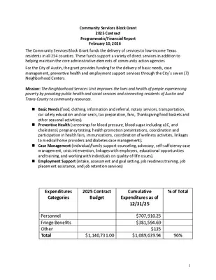
Community Services Block Grant 2025 Contract Programmatic/Financial Report February 10, 2026 The Community Services Block Grant funds the delivery of services to low-income Texas residents in all 254 counties. These funds support a variety of direct services in addition to helping maintain the core administrative elements of community action agencies. For the City of Austin, the grant provides funding for the delivery of basic needs, case management, preventive health and employment support services through the City’s seven (7) Neighborhood Centers. Mission: The Neighborhood Services Unit improves the lives and health of people experiencing poverty by providing public health and social services and connecting residents of Austin and Travis County to community resources. ◼ Basic Needs (food, clothing, information and referral, notary services, transportation, car safety education and car seats, tax preparation, fans, Thanksgiving food baskets and other seasonal activities); ◼ Preventive Health (screenings for blood pressure, blood sugar including a1C, and cholesterol; pregnancy testing; health promotion presentations, coordination and participation in health fairs, immunizations, coordination of wellness activities, linkages to medical home providers and diabetes case management); ◼ Case Management (individual/family support counseling, advocacy, self-sufficiency case management, crisis intervention, linkages with employers, educational opportunities and training, and working with individuals on quality-of-life issues); ◼ Employment Support (intake, assessment and goal setting, job readiness training, job placement assistance, and job retention services) Expenditures Categories 2025 Contract Budget Cumulative Expenditures as of 12/31/25 % of Total Personnel Fringe Benefits Other Total $1,140,731.00 $707,910.25 $381,594.69 $135 $1,089,639.94 96% 1 Transition Out of Poverty Goal Goal Achieved TOP Individuals who transitioned out of poverty 41 49 Success Rate% 120% Austin Public Health Report on PY24 Community Action Plan MISSION: To prevent disease, promote health, and protect the well-being of our community. TOP 5 NEEDS: Housing; Basic Needs; Employment; Health; Income Report Date: December FNPI Outcome Description Target #Enrolled #Achieved Success Rate % 4 4E 5 5B 5D SRV 4C 4I 5A 5JJ 7A 7B 7D 7N Housing Households who avoided eviction Health and Social/Behavioral Development Individuals who demonstrated improved physical health and well being Individuals who improved skills related to the adult role of parents/caregivers Service Description Rent Payments Utility Payments Immunizations (Flu) Food Distribution Case Management Eligibility Determinations Transportation Emergency Clothing 3A.1 Total number of volunteer hours donated to the Agency Programmatic/Administrative Updates 1000 604 604 60% #Enrolled #Achieved 20 50 47 129 21 118 Success Rate % 105% 92% Number Served 604 …
AUSTIN EQUITY OVERLAY STUDY FINAL PRE SE NTATION February 10, 2026 1 AGENDA 01 02 S COPE OVERVIEW Primary Questions & Project Phases REVIEW OF DELIVERABLES Phase Overview FINAL QUES TIONS 03 Project Closeout 2 01 SCOPE OVERVIEW Primary Questions & Project Phases PROJECT UNDERSTANDING that would permit, The City of Austin approved a HOME Phase 2 Ordinance among other entitlements, the ability to build up to three single- family units on what would historically be one single-family lot. The City would like to “study the feasibility, merits, applying an equity/anti-displacement overlay and the impacts that such an overlay could have on affordability, displacement, and property values. The focus of the equity overlay would be to mitigate speculation and displacement by gentrification. and risks of areas most affected in 45 YEARS OF APD URBAN PLANNING AND MANAGEMENT 4 Our deep understanding of the policy and regulatory issues related to community development financing, combined with our experience as planners and real estate developers, gives us a unique perspective on how sustainable housing and economic development influence neighborhood growth and expand housing options. Our firm is widely recognized for its expertise in analyzing identifying disinvestment life cycles, neighborhoods' historical patterns, and designing comprehensive reinvestment strategies that include long-time residents and community stakeholders. PRIMARY QUESTIONS 01 02 03 Based on existing data and analysis, what neighborhoods are at ris k, or have the most potential to be at risk, without some form of E quity Overlay “companion” to the HOME Ordinance geographic expansion? What are the community concerns within the neighborhood areas determined to be most at risk of displacement regarding affordability, dis placement, and property values as they relate to the HOME Ordinance? Displacement Risk Analysis Community Feedback What policies and programs could be put in place to addres s community concerns while at the same time s upporting the goals and objective of the HOME Ordinance? Program Recommendations 5 PROJECT PHASES Displacement Risk Analysis + Community Feedback = Program Recommendations PHAS E 1: Community Engagement Conducted 15 stakeholder interviews virtually and in-person, and attended CDC meeting for Q&A PHAS E 2: Policy/ Program S tudy and Analys is Analysis of City’s previous plans, studies, and density bonuses alongside peer city reviews and HOME policy analysis PHAS E 3: Dis placement Ris k Analys is Analysis of City’s previous anti-displacement studies and updated demographic risk of displacement with census and property data …
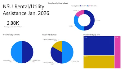
Austin Housing Austin Housing Communications & Engagement Communications & Engagement Community Development Commission | Feb. 10, 2026 Community Feedback Reach those in need Make resources more accessible Listen to those most impacted Increase transparency Share program impact Marketing & Marketing & Outreach Outreach How do we get the word out about our housing services? www.AustinTexas.gov/Housing ▪ Flyers in 7 languages ▪ … 4 Community Newsletter ▪ Monthly email distribution ▪ 9,300+ recipients 5 Flyers in Public Spaces • 24 Library Locations • 11 Eastern Crescent Rec Centers 6 Paid Advertising – TV ▪ TV: KEYE & NEYE, Univision, Austin PBS 7 Paid Advertising – Radio Austin Community Radio ▪ KAZI FM Norsan Media ▪ KTXX FM, KZNX AM KUT/KUTX Waterloo Media ▪ KZLT FM, KGSR FM Univision ▪ KLQB FM, KLJA FM Audacy ▪ KAMX FM, KKMJ FM 8 Paid Advertising – Print & Digital ▪ PRINT The Villager Community Impact Austin South Asian El Mundo ▪ DIGITAL Austin Monitor 9 Project Signage on Sites 10 Media Relations ▪ Tell our story proactively through media partners to reach community members. ▪ Coordinate announcements and event invitations for coverage. ▪ Support responsiveness to questions about programs and resident benefit. ▪ Build trust and transparency through accurate and timely information. 11 Tabling at Community Events 18 community events across Austin in FY25, reaching 560+ residents ▪ Sat, August 23: Imagine Austin Resource Fair ▪ Thurs, August 7: AARP Chapter Meeting ▪ Wed, August 6: District 10 Budget Town Hall & Resource Fair ▪ Sat, August 2: Districts 1 & 4 Budget Town Hall & Resource Fair ▪ Sat, June 28: Party at the People's House ▪ Sat, July 26: CBS Austin Backpack Giveaway (1,500 backpacks) ▪ Sat, June 21: Frost Home Improvement Event ▪ Thurs, June 19: Juneteenth Celebration ▪ Sat, May 31: Austin Home Buyer Fair ▪ Sat, May 17: Austin Veterans Arts Fest & Service Fair ▪ Sat, April 26: Flood Safety Festival ▪ Thurs, April 24: ACC Veterans Resource Fair ▪ Wed, April 16: 2025 Fair Housing Conference + Housing Resource Hub ▪ Sat, April 12: ABREP Community Impact Day ▪ Sat, Oct 26: Austin Energy Community Connections Resource Fair ▪ Sat, Oct 26: Hope Fest ▪ Sat, Oct 19: Frost Home Improvement Event @ Montopolis Recreation and Community Center ▪ Sat, Oct 5: Boo the Flu 12 Collaboration and Partnerships Community Partnerships ▪ Contracted service providers ▪ Community …
COMMUNITY DEVELOPMENT COMMISSION DRAFT MEETING MINUTES JANUARY 13th, 2026 The COMMUNITY DEVELOPMENT COMMISSION convened in a REGULAR MEETING on January 13th, 2026, at CITY HALL, BOARDS AND COMMISSION ROOM, in Austin, Texas. Some members of the commission participated by video conference. Board Members/Commissioners in Attendance: Jenny Achilles Jose Noe Elias (Chair) Cynthia Jaso Raul Longoria Valerie Menard Lyric Wardlow Board Members/Commissioners in Attendance Remotely: Nyeka Arnold Taniquewa Brewster Tisha-Vonique Hood Sonia Martinez Cassandra Medrano Board Members/Commissioners Absent: Ebonie Trice- Oliver JoAnne Ortiz Staff Members in Attendance: Angel Zambrano Miguel Lopez Lorena Lopez Chavarin Marla Torrado Nefertitti Jackmon CALL TO ORDER Chair Elias called the meeting to order at 6:33 PM, with 11 members present. Cassandra Medrano left the dais at 7:15 PM with 10 members present. PUBLIC COMMUNICATION: GENERAL The first 10 speakers signed up prior to the meeting being called to order will each be allowed a three- minute allotment to address their concerns regarding items not posted on the agenda. Zenobia Joseph provided comment concerning Title VI of the Civil Rights Act of 1964 as well as a previous CapMetro presentation. APPROVAL OF MINUTES 1. Approve the minutes of the CDC Regular meeting on December 9, 2025. On Vice Chair Achilles’ motion, Commissioner Menard seconded, and the December 9th, 2025, minutes were approved on a 11-0-0 vote. STAFF BRIEFINGS 2. Staff briefing regarding Community Services Block Grant (CSBG) activities and outcomes. Presentation by Angel Zambrano, Program Manager III, Austin Public Health. Angel Zambrano presented. 3. Staff briefing regarding Austin Housing activities and programs. Presentation by Dr. Marla Torrado, Housing Division Manager, Austin Housing. Dr. Marla Torrado presented. DISCUSSION ITEMS 4. Discussion on “Consolidated Annual Performance and Evaluation Report (CAPER)”. Discussion led by Chase Clement, Financial Manager from Austin Housing. Chase Clement presented. 5. Discussion on “River Park Development and possible impact on the current communities”. Discussion led by Robert Anderson, Project Coordinator from Austin Housing. The City of Austin is committed to compliance with the American with Disabilities Act. Reasonable modifications and equal access to communications will be provided upon request. Meeting locations are planned with wheelchair access. If requiring Sign Language Interpreters or alternative formats, please give notice by calling 512-974-1606 at least 2 days prior to the meeting date. TTY users route through Relay Texas at 711. For more information on the Community Development Commission, please contact Edward Blake at 512-974-3108. CDC Commissioners may contact CTM …
COMMUNITY DEVELOPMENT COMMISSION MEETING MINUTES FEBRUARY 10th, 2026 The COMMUNITY DEVELOPMENT COMMISSION convened in a REGULAR MEETING on February 10th, 2026, at CITY HALL, BOARDS AND COMMISSION ROOM, in Austin, Texas. Some members of the commission participated by video conference. Board Members/Commissioners in Attendance: Jenny Achilles Jose Noe Elias (Chair) Cynthia Jaso Raul Longoria Valerie Menard Lyric Wardlow Board Members/Commissioners in Attendance Remotely: Ebonie Oliver Cassandra Medrano Tisha-Vonique Hood Sonia Martinez Board Members/Commissioners Absent: JoAnne Ortiz Nyeka Arnold Taniquewa Brewster Staff Members in Attendance: Angel Zambrano Lorena Lopez Chavarin (Remotely) Mandy DeMayo Miguel Lopez CALL TO ORDER Chair Elias called the meeting to order at 6:36 PM, with 8 members present. Commissioner Menard joined the dais at 6:48, bringing the total number to 9 members present. PUBLIC COMMUNICATION: GENERAL The first 10 speakers signed up prior to the meeting being called to order will each be allowed a three- minute allotment to address their concerns regarding items not posted on the agenda. Angelina Alanise provided public comment regarding construction near Festival Beach Food Forest APPROVAL OF MINUTES 1. Approve the minutes of the CDC Regular meeting on January 13, 2026. On Vice Chair Achilles’ motion, Commissioner Longoria seconded, and the January 13th, 2026, minutes were approved on an 7-0-1 vote. Commissioner Medrano was off the dais. STAFF BRIEFINGS 2. Staff briefing regarding Community Services Block Grant (CSBG) activities and outcomes. Presentation by Angel Zambrano, Program Manager III, Austin Public Health. Angel Zambrano presented. 3. Staff briefing regarding Austin Housing activities and programs. Presentation by Nefertitti Jackmon, Community Displacement Prevention Officer, Austin Housing. Caleb Brown presented. DISCUSSION ITEMS 4. Discussion on the City of Austin Equity Overlay. Discussion led by APD Urban Planning Management and Alan Pani, Planner Principal, from Austin Planning. Alan Pani presented. The City of Austin is committed to compliance with the American with Disabilities Act. Reasonable modifications and equal access to communications will be provided upon request. Meeting locations are planned with wheelchair access. If requiring Sign Language Interpreters or alternative formats, please give notice by calling 512-974-1606 at least 2 days prior to the meeting date. TTY users route through Relay Texas at 711. For more information on the Community Development Commission, please contact Edward Blake at 512-974-3108. CDC Commissioners may contact CTM for email/technology assistance: 512-974-4357. 5. Discussion on the Austin Housing 2026 Marketing and Outreach Plan. Discussion led by Veronica Samo, Public Information and …
REGULAR MEETING OF THE 2026 BOND ELECTION ADVISORY TASK FORCE MONDAY, February 9, 2026, AT 6:00 PM PERMITTING AND DEVELOPMENT CENTER, EVENTS CENTER, ROOM 1405 6310 WILHELMINA DELCO DRIVE AUSTIN, TEXAS Some members of the 2026 Bond Election Advisory Task Force may be participating by video conference. The meeting may be viewed online at: http://www.austintexas.gov/page/watch-atxn- live Public comment will be allowed in-person or remotely via telephone. Speakers may only register to speak on an item once either in-person or remotely and will be allowed up to three minutes to provide their comments. Registration no later than noon the day before the meeting is required for remote participation by telephone. To register to speak remotely, contact Nicole Hernandez, 512-974-7644, nicole.hernandez@austintexas.gov. CURRENT MEMBERS: Mary Hager, Chair Ana Aguirre Nicole Conley Richard DePalma Robert Fiedler Donald Jackson Garry Merritt Katrina Miller Kenneth Standley Ben Suddaby Heyden Walker CALL TO ORDER Frances Jordan, Vice Chair Tina Cannon Charles Curry JC Dwyer Jeremiah Hendricks Noelita Lugo Luke Metzger Dewi Smith Rachel Stone David Sullivan Kaiba White AGENDA PUBLIC COMMUNICATION: GENERAL The first 10 speakers signed up prior to the meeting being called to order will each be allowed a three- minute allotment to address their concerns regarding items not posted on the agenda. APPROVAL OF MINUTES 1. Approve the minutes of the 2026 Bond Election Advisory Task Force Regular Called meeting on January 12, 2025. STAFF BRIEFINGS 2. Staff briefing regarding 2026 Bond Phase 3 engagement update. Presentation by Jessica King, Chief Communication Director, Lucero Arechiga, Community Engagement Consultant, Andres Cantu, Acting Public Communication Information and Marketing Manager, Austin Communications and Engagement. DISCUSSION ITEMS 3. Discussion of bond spending eligibility questions and other financial considerations, including review of financial Q&A prepared by Austin Financial Services. DISCUSSION AND ACTION ITEMS 4. 5. Approve the modified criteria to be used by full Bond Election Advisory Task Force to prioritize projects recommended by Working Groups. Approve any necessary revisions to the work plan resulting from the January 26 meeting cancellation WORKING GROUP UPDATE 6. 7. 8. Update from Transportation & Electrification Working Group regarding initial draft recommendation. Update from Investments in Facilities and Assets Working Group regarding initial draft recommendation. Update from Parkland and Open Space Working Group regarding initial draft recommendation. FUTURE AGENDA ITEMS ADJOURNMENT The City of Austin is committed to compliance with the Americans with Disabilities Act. Reasonable modifications and equal access to communications will …
2026 Bond | Outreach & Engagement Monday, February 9, 2026 Agenda • Timeline • Phase III: Community Open Houses & Survey II • Outreach and Engagement Support • Questions & Answers Outreach and Engagement Schedule APR – MAY 2025 JUNE 2025 JULY 2025 NOV 2025 Staff-led outreach and engagement efforts begin. Community survey opens May 29. June 23 survey comes to a close. Staff begin to work on the preliminary report. July 28 Presentation of community feedback. Town hall planning and coordination. In November, the BEATF will host three community listening sessions where community members can drop in, learn about who the BEATF is, their goals, and gather insights from community priorities. 7/28/25 2026 BOND 3 Outreach and Engagement Schedule January 2026 JAN – FEB 2026 JAN – APRIL 2026 City Staff will provide an initial recommendation to Mayor and City Council City Staff will host Phase III Community Engagement with Open Houses and launch survey #2 on potential bond projects (BEATF) Working groups will present recommendations to the full BEATF. April 27, 2026 BEATF will provide recommendation to Mayor and Council 7/28/25 2026 BOND 4 Outreach and Engagement Schedule MAY 2026 AUGUST 2026 NOVEMBER 2026 City Council Ordinance considers to call for the bond election by August 6, 2026 Nov 3. Bond Election City Staff will provide a FINAL recommendation to the Mayor and City Council. Council Discussion and Final Resolution: Work Session May 19 Council Meeting – May 21 2026 BOND 5 Phase III: Community Open Houses & Survey II Bond 2026 Open Houses Phase 3 of the Bond 2026 engagement focuses on community open houses, designed to deepen understanding, invite informed input, and bring community members closer to the decision-making process. Montopolis Recreation Center 1200 Montopolis, Dr. Austin, TX 78741 Tuesday, February 17 | 4 - 8 pm Northwest Recreation Center 2913 Northland Dr, Austin, TX 78757 Saturday, February 21 | 10 am – 2 pm Virtual Meeting Tuesday, February 24 | 11 am – 1 pm Permitting & Development Center 6310 Wilhelmina Delco Dr, Austin, TX 78752 Wednesday, February 25 | 4 - 8 pm Conley-Guerrero Senior Center 808 Nile St, Austin, TX 78702 Saturday, February 28 | 11 am - 3 pm 2026 BOND 7 Bond 2026 Open Houses Each open house is designed as a walk-up, interactive experience, allowing community members to participate at their own pace. Community members will be able to: Understand …
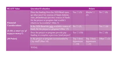
BEATF Value Question/Evaluation Does the funding from the 2026 Bond open up other non-City sources of funds (federal, state, philanthropic/private) sources of funds for the project or program that wouldn’t otherwise be available? (Max 5) Yes ☐ (5) Points Maybe ☐ (2) No ☐ (0) Financial Considerations (Is this a smart use of taxpayer money?) [30 Points] Is the 2026 Bond the only available source of funds for the project or program? (Max 15) No ☐ (5) Does the project or program provide gap funding to complete a previous bond project? Yes ☐ (10) Is the project or program recommended by City staff? (Max 10) Top 2 from department ☐ (10) Top 3 from department ☐ (5) TOTAL Yes ☐ (0) No ☐ (0) Other ☐ (2) BEATF Value Question/Evaluation Equity and Access (Does this help communities that have been underserved?) [30 Points] Does the project or program serve historically underserved populations and disinvested neighborhoods? (Max 10) Does the project or program serve a documented service gap? (Max 10) Is the project or program accessible to all? (Max 10) Does the project or program address essential health and life safety? TOTAL Points Yes ☐ (7.5) No ☐ (0) Yes ☐ (7.5) No ☐ (0) Yes ☐ (7.5) No ☐ (0) Yes ☐ (7.5) No ☐ (0) BEATF Value Question/Evaluation Points Community Support (Does this project or program respond to requests from the public?) Did the project or program receive public support? (Max 10) Strong ☐ (10) Medium ☐ (5) None ☐ (0) [10 Points] TOTAL BEATF Value Question/ Evaluation* Carbon Impact (Max 15) Negative ☐ (15) Zero or very small ☐ (10) Moderate after mitigation☐ (5) Environmentally Beneficial (Does this project or program help or hurt our environmental goals?) [30 Points] Air, Water and Land Pollution Impact (Max 7) Reduces pollution ☐ (7) Zero or very small impact ☐ (5) Moderate impact after mitigation ☐ (2) Maximized ☐ (8) Significant but not all ☐ (5) Some/little ☐ (2) None or no info provided ☐ (0) Green construction practices (low-carbon materials, solar, etc.) maximized and/or wildlife benefits (Max 8) TOTAL Points Significant w/ little or no mitigation☐ (0) Significant w/ little or no mitigation ☐ (0)
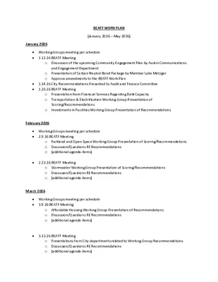
BEATF WORK PLAN [January 2026 – May 2026] January 2026 • Working Groups meeting per schedule • 1.12.26 BEATF Meeting o Discussion of the upcoming Community Engagement Plan by Austin Communications and Engagement Department o Presentation of Carbon Neutral Bond Package by Member Luke Metzger o Approve amendments to the BEATF Work Plan • 1.14.26 City Recommendations Presented to Audit and Finance Committee • 1.26.26 BEATF Meeting o Presentation from Financial Services Regarding Debt Capacity o Transportation & Electrification Working Group Presentation of Scoring/Recommendations Investments in Facilities Working Group Presentation of Recommendations o February 2026 • Working Groups meeting per schedule • 2.9.26 BEATF Meeting o Parkland and Open Space Working Group Presentation of Scoring/Recommendations o Discussion/Questions RE Recommendations o [additional agenda items] • 2.23.26 BEATF Meeting o Stormwater Working Group Presentation of Scoring/Recommendations o Discussion/Questions RE Recommendations o [additional agenda items] March 2026 • Working Groups meeting per schedule • 3.9.26 BEATF Meeting o Affordable Housing Working Group Presentation of Recommendations o Discussion/Questions RE Recommendations o [additional agenda items] • 3.23.26 BEATF Meeting o Presentations from City departments related to Working Group Recommendations o Discussion/Questions RE Recommendations o [additional agenda items] April 2026 • 4.13.26 BEATF Meeting o Presentations from City departments related to Working Group Recommendations o Discussion/Questions RE Recommendations o [additional agenda items] • 4.27.26 BEATF Meeting o Discussion and possible action on BEATF Recommendations o [additional agenda items] May 2026 • 5.4.26 BEATF Meeting o Discussion and possible action on BEATF Recommendations o [additional agenda items]
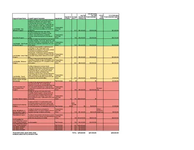
Department Departmen t Priority Average Score July Full Department Priority List 1.21.26 Priority City Staff Recommendation s 1.21.26 Staff Notes 1.21.26 WG Initial Recommendations ($300 M) 1 81.7 $81,000,000 $33,000,000 $81,000,000 1 74.2 $65,000,000 $30,000,000 $58,700,000 1 79.3 $20,000,000 $10,000,000 $20,000,000 1 1 61.5 $80,000,000 $30,000,000 $35,000,000 69.1 $40,000,000 $15,000,000 $40,000,000 Project/Program Description Funding to fill gaps in the pedestrian system by building new sidewalks and shared streets, prioritizing high-need areas within ¼ mile of schools, bus stops, and parks. Funding will also support sidewalks on both sides of arterial and collector streets and one side of residential streets, enhancing accessibility and comfort for pedestrians. Funding to implement Vision Zero safety programs including but not limited to safety corridors, major intersections, pedestrian crossings, speed management, and systemic safety. Funding for safety improvements around schools including sidewalks, curb ramps, bike lanes, curb extensions, pedestrian crossing islands, school zone beacons, pedestrian hybrid beacons, and traffic signals. Funding for land acquisition, engineering, and construction of Tier I urban trails; route identification and design for Tier II trails; and trail connections to existing transportation infrastructure. Funding also supports designing and building trail connections to address barriers in the active transportation network across both tiers. Funding to design and install bicycle facilities supporting a citywide All Ages and Abilities (AAA) network, achieving up to 75% completion of the AAA system. Funding to design and construct transit- supportive infrastructure at high-priority locations, as identified in the 2023 Transit Enhancement Infrastructure Report. Improvements include pedestrian crossings and first/last mile connections near bus stops, transit priority lanes, signal modifications, bus queue jump signals, and safety enhancements like access and curb management near transit facilities. Transportation and Public Works Transportation and Public Works Transportation and Public Works Transportation and Public Works Transportation and Public Works Transportation and Public Works 1 63.7 $19,000,000 $7,000,000 $7,000,000 $7,300,000 Fleet Services N/A 60 0 $0 Funding for the design and construction of improvements to 6th, 7th, and 8th streets downtown as appropriate and identified within the ACT Plan (and achievable in a 6-year period). Construction in downtown will be phased to limit disruptions. Funding for design and construction of the Complete Streets program. Improvements will build on Preliminary Engineering Reports that have already been completed. This program aims to enhance safety, multimodal access, and connectivity. Transportation and Public Works Transportation and Public Works 1 38.8 $80,000,000 $20,000,000 6th street only 10 48.1 $285,000,000 …
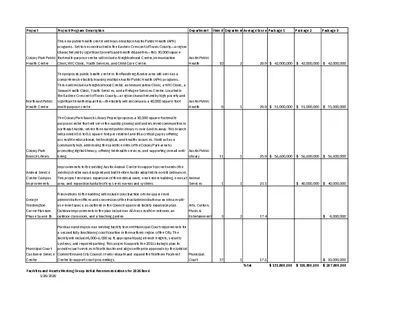
Project Project/Program Description Department Item # Department Priority Average Score Package 1 Package 2 Package 3 This new public health center will house multiple Austin Public Health (APH) programs. Set to be constructed in the Eastern Crescent of Travis County—a region characterized by significant poverty and health disparities—this 30,000 square- foot multi-purpose center will include: Neighborhood Center, Immunization Clinic,WIC Clinic, Youth Services, and Child Care Center. Austin Public Health Colony Park Public Health Center The proposed public health center in the Rundberg/Braker area will serve as a comprehensive facility housing multiple Austin Public Health (APH) programs. These will include a Neighborhood Center, an Immunization Clinic, a WIC Clinic, a Sexual Health Clinic, Youth Services, and a Refugee Services Center. Located in the Eastern Crescent of Travis County—a region characterized by high poverty and significant health disparities—the facility will encompass a 40,000 square-foot multi-purpose center. Austin Public Health Northeast Public Health Center 10 2 29.9 $ 42,000,000 $ 42,000,000 $ 42,000,000 9 1 29.9 $ 51,000,000 $ 51,000,000 $ 51,000,000 The Colony Park Branch Library Project proposes a 30,000 square-foot multi- purpose center that will serve the rapidly growing and underserved communities in northeast Austin, where the nearest public library is over 8 miles away. This branch will provide 0.6 to 0.8 square feet per resident and fill a critical gap by offering accessible educational, technological, and health resources. It will act as a community hub, addressing the specific needs of the Colony Park area by promoting digital literacy, offering telehealth services, and supporting overall well- being. Colony Park Branch Library Austin Public Library 11 Animal Service Center Campus Improvements Improvements to the existing Austin Animal Center to support current needs (the existing shelter was designed and built before Austin adopted its no-kill ordinance). This project envisions expansion of the medical ward, new kennel building, new cat area, and expansion/update of key service areas and systems. Animal Services George Washington Carver Museum Phase 1a and 1b Renovations to the building will include construction of new upper-level administrative offices and conversion of the front administrative area into a multi- use event space, as outlined in the Council-approved facility expansion plan. Outdoor improvements in the plan include an ADA-accessible restroom, an outdoor classroom, and a teaching garden. Arts, Culture, Music & Entertainment 1 3 1 1 2 25.9 $ 58,800,000 $ 58,800,000 $ 58,800,000 23.1 $ 40,000,000 $ 40,000,000 17.4 $ 6,000,000 Purchase …
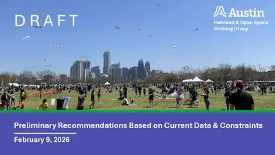
D R A F T Parkland & Open Space Working Group Preliminary Recommendations Based on Current Data & Constraints February 9, 2026 Information Reviewed Included but Not Limited to: • Community Input • Austin Parks & Recreation Presentations and Information • Austin Climate Action and Resilience (ACAR) Presentations and Information • Capital Delivery Services (CDS) Engineering Focused Input Parkland & Open Space Working Group In total - 56 Projects within Six Program Categories Evaluated. Preliminary Recommendations Include Considerations on: • Extreme Critical Needs • Evaluation Criteria Rubric • Credit Rating Impact • Bond Capacity • Entire Bond Program Bottom Line – We Believe the Real Need is Greater than What Can Be Funded at the Moment. Preliminary Recommendations Based on Current Data & Constraints. February 9, 2026 Preliminary Bond Recommendations Department Priority Program Name Description Priority 1 Building Renovation and Replacement Program; and Maintenance Centers Funding for renovation /rehabilitation or replacement of existing Parks and Recreation maintenance facilities and assets, including ADA and safety improvements along w/ bathroom renovations (added by working group). Parkland & Open Space Working Group Council District Department Request Initial Working Group Recommendation Citywide $85,000,000 $75,000,000 Priority 1 Parkland Acquisition Program Funding for the acquistion of parkland that includes land to fill critical gaps within trails, greenbelts and greenways; land to fulfill the Colorado River Corridor Vision Plan shared use trail; and neighborhood/pocket parks within park deficient areas. Citywide $100,000,000 $55,000,000 Priority 2 Aquatic Programs Funding for major renovations or replacements of existing City pools. Citywide $60,000,000 $35,000,000 Priority 3 Parkland Infrastructure Program Funding for the improvement or replacement of park infrastructure, such as playscapes, trails, parking lots, roadways, athletic fields/facilities, and City cemeteries. Citywide $40,000,000 $15,000,000 Priority 2 Parkland Improvements Funding for the development of existing City parks, including neighborhood parks, district parks, metro parks, greenbelts, special parks, and downtown squares. Citywide $70,000,000 Priority 3 Recreation and Senior Center Improvement Program Funding for renovations, rehabilitations, and additions to existing senior and recreation centers and assets. Priorities and needs identified in the 2024 Recreation and Senior Center Facility Assessment and Gap Analysis. Citywide $55,000,000 0 0 Parks and Open Space Total: $ 410,000,000 $ 180,000,000 Preliminary Recommendations Based on Current Data & Constraints. February 9, 2026 Parkland & Open Space Working Group Future Input May Include: • Additional Direction by Council • New Funding Information • Alternative Funding Recommendations such as: ▪ Expanding concession opportunities for …
2026 Bond Election Advisory Task Force (BEATF) REGULAR CALLED MEETING MINUTES Monday, February 9, 2026 The 2026 Bond Election Advisory Task Force convened in a Regular meeting on Monday February 9, 2026, at 6310 Wilhelmina Delco Drive in Austin, Texas. Chair Hager called the 2026 Bond Election Advisory Task Force Meeting to order at 6:05 p.m. Board Members/Commissioners in Attendance: Mary Hager, Chair Frances Jordan, Vice Chair Ana Aguirre Charles Curry Richard DePalma Luke Metzger Kenneth Standley Heyden Walker Kaiba White Board Members/Commissioners in Attendance Remotely: Tina Cannon JC Dwyer Noelita Lugo Rachel Stone Ben Suddaby David Sullivan PUBLIC COMMUNICATION: GENERAL • Andi Brauer- Spoke to the Task Force about homeless advocacy. • Martin Jones- Spoke to the Task Force about a bond request for Austin Studios. 1 • Awais Azhar- Spoke to the Task Force about the need for affordable housing. • Mel Leblanc – Spoke to the Task Force advocating a bond package for affordable housing and homelessness. • Alfredo Reyes, Jr. – Spoke to the Task Force about affordable housing. • Cindi Reed- Spoke to the Task Force to prioritize families and children, libraries, recreation centers and multi-use spaces in underserved areas. APPROVAL OF MINUTES 1. Approve the minutes of the 2026 Bond Election Advisory Task Force REGULAR MEETING on January 12, 2026. The minutes from the meeting of (1/12/2026) were approved on MEMBER Jordan’s motion, MEMBER Walker’s second on a (14-0) vote. Member Cannon abstaining and Members Conley, Fiedler, Hendricks, Jackson, Merritt, Miller and Smith absent. STAFF BRIEFINGS 2. Staff briefing regarding 2026 Bond Phase 3 engagement update. Presentation by Jessica King, Chief Communication Director, Lucero Arechiga, Community Engagement Consultant, Andres Cantu, Acting Public Communication Information and Marketing Manager, Austin Communications and Engagement. The presentation was made by Lucero Arechiga, Community Engagement Consultant, Austin Communications and Engagement. Briefing included information about public input and community engagement. DISCUSSION ITEMS 3. Discussion of bond spending eligibility questions and other financial considerations, including review of financial Q&A prepared by Austin Financial Services. Discussion with Kim Olivares, Director, Austin Financial Services regarding questions from the Task Force. DISCUSSION AND ACTION ITEMS 4. 5. Approve the modified criteria to be used by full Bond Election Advisory Task Force to prioritize projects recommended by Working Groups. Item not discussed due to time expiring. Approve any necessary revisions to the work plan resulting from the January 26 meeting cancellation The motion to revise …
SPECIAL CALLED MEETING of the TOURISM COMMISSION BOARD MONDAY, FEBRUARY 9, 2026, AT 2:30 P.M. CITY HALL, COUNCIL CHAMBERS ROOM 1001 300 W. 2ND STREET AUSTIN, TEXAS Some members of the Tourism Commission may be participating by videoconference. The meeting may be viewed online at: http://www.austintexas.gov/page/watch-atxn-live Public comment will be allowed in-person or remotely via telephone. Speakers may only register to speak on an item once either in-person or remotely and will be allowed up to three minutes to provide their comments. Registration no later than noon the day before the meeting is required for remote participation by telephone. To register to speak remotely, contact Felicia Burleson, (512) 978-1325 or felicia.burleson@austintexas.gov CURRENT COMMISSIONERS: Ed Bailey, Chair, D5 Greg Chanon, D2 Francisco “Cisco” Gamez, D1 Anna Panossian, Mayoral District 7 (vacant) District 9 (vacant) Cristina Masters, Vice Chair, D10 Bishop Chappell, D6 Stefani Mathis, D8 Dani Pruitt, D3 District 4 (vacant) AGENDA CALL TO ORDER PUBLIC COMMUNICATION: GENERAL The first [10] speakers signed up prior to the meeting being called to order will each be allowed a three-minute allotment to address their concerns regarding items not posted on the agenda. APPROVAL OF MINUTES 1. Approve the minutes of the Tourism Commission Board Regular Meeting on January 14, 2026 STAFF BRIEFINGS 2. Staff briefing from Staff Liaison, Felicia Burleson, regarding commission board recent vacancy filled and new status, deadlines, resources, and updates. DISCUSSION ITEMS 3. Presentation by the Austin Convention Center regarding design concepts for the new Austin Convention Center footprint/pad and discuss how the redevelopment will transform integration with surrounding areas. Presentation by Katy Zamesnik, Interim Director. 4. Presentation by the Downtown Austin Alliance regarding the Downtown Austin Alliance’s role in the planning process for creating a smarter, more integrated downtown. Presentation by Davon Barbour, Executive Director. 5. Presentation by the Waterloo Greenway Conservancy regarding the Waterloo Greenway Project - Phase II: The Confluence, exploring the role of planning in shaping a smarter, more integrated downtown, with a focus on the new Austin Convention Center design and tourism initiatives. Presentation by John Rigdon, Chief Planning & Design Officer. WORKING GROUP UPDATE 6. Update from the Short-Term Rental Working Group on any new reports regarding the STR’s new focus and efforts for recommendations. FUTURE AGENDA ITEMS ADJOURNMENT The City of Austin is committed to compliance with the Americans with Disabilities Act. Reasonable modifications and equal access to communications will be provided upon …
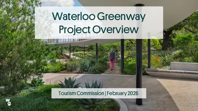
Waterloo Greenway Project Overview Tourism Commission | February 2026 WEST AUSTIN OLD ENFIELD WEST UNIVERSITY UNIVERSITY OF TEXAS FRENCH PLACE ROLLINGWOOD L a d y CLARKSVILLE B i r d L a k e BARTON HILLS ZILKER BOULDIN CREEK CAPITOL CENTRAL EAST AUSTIN EAST CESAR CHAVEZ HOLLY First Congress TRAVIS HEIGHTS The Impacts of Growth Waller Creek: Infrastructural Overload Flooding, Damage, and Economic Stagnation 100-year storm floods 28 acres of downtown Austin This is no longer a landscape... City of Austin Flood Control Tunnel Governance and Project Leadership • • • • • • Sponsoring Departments: PARD & Watershed Protection Code Compliance Public Health, Safety & Welfare Environmental Stewardship Subject Matter Expertise Capital Project Funding • Community Leadership • Operations & Maintenance • • • • Programming & Art Environmental Stewardship Design Excellence Capital Project Funding Council approved project and partnership Waller Creek Local Government Corporation • Representatives of City Council • Open meetings and citizen communication • Approval of contracts and design/construction budgets Public-Private Partnership Public Oversight MVVA: Design Competition and Project Vision • 35 acres of parks and open space along 1.5 miles of Waller Creek • A connected series of parks, stitching together over 3 miles of trails with dozens of connections to the right-of-way • Robust regional landscapes and restoration of Waller Creek • Actively programmed and managed by Waterloo Greenway Conservancy to the highest standard Phase 1: Waterloo Park Lady Bird Lake C E S A R C H A V E Z S T Pontoon Bridge Austin Convention Center Emma S. Barrientos Mexican American Cultural Center Creek Delta RAINEY ST D A V S S T I D R I S K I L L S T Palm School Palm Park Texas Capitol N 2 N D S T 3 R D S T 4 T H S T 5 T H S T 6 T H S T 7 T H S T 8 T H S T 9 T H S T 1 0 T H S T 1 1 T H S T 1 2 T H S T Moody Amphitheater 1 5 T H S T SAN JACINTO BLVD Frank C. Erwin, Jr. Special Events Center TRINITY ST NECHES ST RED RIVER ST SABINE ST Red River Cultural District The Refuge IH-35 • • • • • Waterloo Park Dell Seton Medical Center Dell Medical School at the University of …