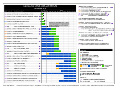
SCHEDULE OF ACTIVE CODE AMENDMENTS NOVEMBER 2024 LEAD CASE NO. CODE AMENDMENT 2024 2025 JUL JUN NOV DEC JAN FEB MAR APR MAY AUG SEP OCT NOV DEC DENSITY BONUS COMPREHENSIVE STUDY A comprehensive analysis with recommendations to streamline, calibrate, and combine existing and proposed programs. PLD C20-2024-017 PLANNED DEVELOPMENT AREA 2 (PDA2) PLD C20-2024-022 DB FOR COMMERCIAL HWY & INDUSTRIAL (DB240) DSD C20-2023-045 SITE PLAN LITE PH 2 & INFILL LOTS WPDC20-2022-025 COLORADO RIVER PROTECTIONS TPW C20-2024-021 SAFETY BOLLARDS PLD N/A DENSITY BONUS COMPREHENSIVE STUDY PLD C20-2024-003 EAST RIVERSIDE CORRIDOR REG. PLAN UPDATE DSD C20-2024-014 STR MODIFICATIONS DSD C20-2024-016 PRESERVATION BONUS UPDATE PHASE 1 DSD C20-2024-013 ARTICLE 9 LANDSCAPING DSD C20-2024-015 TREE PRESERVATION & PLANTING REQUIREMENTS PLD C20-2024-010 UNO UPDATE WPDC20-2022-025 GREENFIELD DRAINAGE FOR REDEVELOPED SITES PLD C20-2024-004 ETOD OVERLAY (PH 2) PLD N/A NEW ZONING DISTRICTS STUDY HD C20-2023-037 S.M.A.R.T. HOUSING UPDATES PH 2 PLD TBD DENSITY BONUS COMPREHENSIVE AMENDMENTS PLD C20-2024-008 DOWNTOWN PARKING MODIFICATIONS PH 2 PLD C20-2024-018 DDB/DOWNTOWN AMENDMENTS PLD C20-2023-023 NOTIFICATION MODIFICATION PLD TBD NEW ZONING DISTRICTS PLD TBD HOME (FUTURE PHASES) PLD TBD CRESTVIEW TOD UPDATE PLD C20-2018-004 MIRRORED GLASS AE C20-2023-014 UNDERGROUND ELECTRIC UTILITY DISTRIBUTION LINES PLD C20-2023-031 FRONT OR SIDE YARD PARKING FILING DEADLINES PLD C20-2023-032 MOBILE FOOD ESTABLISHENT FILING DEADLINES PLD C20-2023-036 TENANT NOTIFICATION AND RELOCATION PH 2 TIMELINES TO BE DETERMINED PLD C20-2022-003 SOUTH CENTRAL WATERFRONT COMB. DIS. & DB PLD C20-2024-002 NBG REG. PLAN (SIGNAGE) DSD C20-2023-003 SUBSTANDARD LOTS TPW C20-2023-040 ELIMINATE MIN. PARKING REQUIREMENTS PH 2 PLD C20-2024-012 NBG REG. PLAN (BONUS PROGRAM) PLD C20-2024-020 PRESERVATION BONUS UPDATE PHASE 2 PLD N/A CRESTVIEW TOD HEIGHT AMENDMENT STAFF RECOMMENDS ADDRESSING THESE ITEMS THROUGH MORE COMPREHENSIVE CODE AMENDMENTS ADDRESS BY C20-2023-045 SITE PLAN LITE PHASE 2 & INFILL LOTS: DSD C20-2021-002 AFFORDABILITY UNLOCKED SITE PLAN CHANGES ADDRESS BY NEW ZONING DISTRICTS: PLD C20-2022-018 NOXIOUS LAND USES PLD C20-2023-007 TOWN ZONING (COULD BE ADDRESSED THROUGH THE DENSITY BONUS COMPREHENSIVE AMENDMENTS) ADDRESS BY DENSITY BONUS COMPREHENSIVE AMENDMENTS: HD C20-2023-016 SINGLE FAMILY OWNERSHIP BONUS PROGRAM HD C20-2023-017 AFFORDABILTY UNLOCKED EXPANSION PLD C20-2023-042 PUBLIC SAFETY DENSITY BONUS ADDRESS BY C20-2024-010 UNO UPDATE: PLD C20-2024-005 UNO HEIGHT RESTRICTIONS ADDRESS BY C20-2024-018 DDB/DOWNTOWN AMENDMENTS PLD C20-2024-008 DOWNTOWN PARKING MODIFICATIONS PH 2 CHART KEY LEAD DEPARTMENT AE AUSTIN ENERGY DSD DEVELOPMENT SERVICES DEPARTMENT EDD ECONOMIC DEVELOPMENT DEPARTMENT HD HOUSING DEPARTMENT PLD PLANNING DEPARTMENT TPW TRANSPORTATION AND PUBLIC WORKS DEPARTMENT WPD WATERSHED PROTECTION DEPARTMENT LAND DEVELOPMENT CODE AMENDMENT …
Downtown Commission Meeting Minutes Wednesday, November 20, 2024 DOWNTOWN COMMISSION REGULAR MEETING WEDNESDAY, November 20, 2024 The Downtown Commission convened the regular meeting on Wednesday, November 20, 2024, at 6310 Wilhelmina Delco Drive in hybrid meeting format. COMMISSIONERS IN ATTENDANCE August Harris, Chair Ralph E Ishmael Jr., Vice-Chair Peter Breton Charles Peveto David Carroll Kimberly Levinson Anne-Charlotte Patterson Sania D. Shifferd COMMISSIONERS IN ATTENDANCE REMOTELY Liz Coufal Jennifer Franklin Amy Mok CALL TO ORDER Chair Harris called the meeting of the Downtown Commission to order at 5:36 pm. PUBLIC COMMUNICATION: GENERAL None. APPROVAL OF MINUTES 16, 2024. 1. Approve the minutes of the Downtown Commission regular called meeting on October The minutes from the meeting on October 16, 2024, were approved on Vice Chair Ishmael’s motion, Commissioner Levinson’s second on an 8-0 vote. Commissioner Lavigne was absent. Downtown Commission Meeting Minutes DISCUSSION ITEMS Wednesday, November 20, 2024 2. Presentation on benchmarking downtown plans in comparable cities by Melissa Barry, Chief Program Officer, Downtown Austin Alliance, and discussion of the update to the Downtown Austin Plan. The presentation was made by Melissa Barry, Chief Program Officer, Downtown Austin Alliance. 3. Presentation on the Great Streets Plan by Jill Amezcua, Program Manager II, Planning Department. The presentation was made by Jill Amezcua, Program Manager II, Planning Department. 4. Presentation on the Congress Avenue Urban Design Initiative by Laura Dierenfield, Division Manager, Austin Transportation and Public Works. The presentation was made by Laura Dierenfield, Division Manager, Austin Transportation and Public Works. DISCUSSION AND ACTION ITEMS 5. Approve the formation of a Working Group to contribute input to the update of the Downtown Austin Plan. The motion to approve the formation of a Working Group to contribute input to the update of the Downtown Austin Plan was approved on Commissioner Levinson’s motion, Commissioner Peveto’s second on a 7-0 vote. Commissioner Coufal was off the dais. Commissioner Lavigne was absent. Vice Chair Ishmael, Commissioners Levinson, Peveto and Shifferd were added to the working group without objection. FUTURE AGENDA ITEMS Waterloo Greenway (Harris, Levinson) ADJOURNMENT Chair Harris adjourned the meeting at 7:25 pm without any objection.
Downtown Austin Plan Update Downtown Commission December 18, 2024 Agenda Background Pre-Planning Process Next Steps A Background: …The 2011 Downtown Austin Plan 2011 Downtown Austin Plan 7 Transformative Steps 1). Create Signature Parks 2). Urban Rail 3). East 6th Street “Re-imagined” 4). Affordable Housing 5). Downtown Infrastructure 6). LDC Amendments 7). “Central-City” Economic Development Corporation 4 How It Works! 7 Total Plan Elements – 7 Overall Goals – 30 Recommendations – 114 Actions – Key Considerations 9 Downtown Districts (Sub-Areas) – Individual Goals – Character & Form 5 Downtown Austin Plan (Resolution No. 20240814-028) …The Update! Resolution No. 2024084-028 • Initiate updates to the Downtown Austin Plan […], covering the next 10 years at minimum, reviewing updates through an equitable, resilient, and sustainable lens. • Engage with stakeholders […] in envisioning the future of Downtown, identifying the needs of those who live, work, and visit Downtown, and identifying solutions. • Ensure the implementation and coordination of recently completed projects and plans that are shaping Downtown’s future, to incorporate the needs of unique features of Downtown, and to address the issues that affect growth [ ]. 7 Resolution No. 2024084 - 028 • Provide detailed information for implementation including cost estimates, potential partners, funding opportunities, financial tools, and any necessary code amendments for identified projects, programs, policies, and infrastructure recommendations. • Provide a memo to Council by Mid-February, outlining estimated cost, scope, and preliminary timeline of the Downtown Austin Plan update, identifying City staff resources, and potential external partnerships or third parties that can assist in providing resources for plan development. 8 “How do we know where we are going if we don’t know where we are at?” The Pre – Planning Process August 2024 - March 2025 Preliminary Research – Implementation Status Review* – Initial Stakeholder Engagement* Produce Draft (February) – Scope (V1) – Timeline (V1) Cost Estimate (March) – Estimate based on Scope (V1) *Ongoing Activity beyond March 2025 March 2025 – June 2025 Council Approval of Direction Preliminary Research (cont’d.) – Implementation Status Review* – Broadened Initial Stakeholder Engagement* Synthesize Findings – 2011 DAP Implementation Status Report – Initial Stakeholder Findings Report Produce Final – Updated Scope (V1) / Potential Scope (V2), – Updated Timeline (V1) / Potential Timeline (V2) – Updated Cost Estimate (V1) / Potential Cost Estimate (V2) 10 2011 DAP Implementation Status Review Activity 1: …
CITY OF PORTLAND LOW CARBON CONCRETE INITIATIVE City of Austin Joint Sustainability Commission December 18th, 2024 Cary Watters Sustainable Procurement Program Manager Agenda • Origin of the initiative • Initiative development • Pilot projects • Embodied carbon threshold • Exemptions • Misconceptions • Lessons learned • Open discussion 2 Origin of the initiative 2016 Sustainable Supply Chain Analysis 3 Timeline of City and State Partnership to Advancement of Low Carbon Concrete City of Portland Concrete EPD Requirements for City Projects City of Portland Buy Clean policy developed Advisory committee Data collection Pilot projects Concrete Embodied Carbon (GWP) Threshold Requirements 2016 2017 2018 2019 2020 2021 2022 2023 State of Oregon Concrete EPD Incentive Program Buy Clean legislation introduced, did not pass Buy Clean legislation introduced again, did not pass Buy Clean Oregon Passes (DOT only) State of Oregon 4 Steps in the initiative: Convened a committee of stakeholders. 1. 2. 3. 4. 5. Established a product-specific EPD requirement for concrete mixes used on City projects Established a baseline average EPD for Portland area for Portland cement concrete Conducted pilot tests of lower-embodied carbon concrete mixes Established requirements for GWP thresholds for concrete mixes 5 Step 1: Low Carbon Concrete Committee Representing Stakeholder Type City of Portland – Sustainable Procurement Program City Bureau/Committee Convener City of Portland – Water Bureau City of Portland – Bureau of Transportation City of Portland – Bureau of Environmental Services - Materials Testing Lab Oregon Department of Environmental Quality 4 Portland area ready-mix suppliers 3 structural and materials engineers 3 contractors – residential, commercial, infrastructure Architect City Bureau City Bureau City Bureau Engineers Contractor Designer Subject Matter Expert – Low Carbon Concrete Concrete Producers 6 Step 2: City of Portland Low Carbon Concrete Procurement Policy for EPDs 7 Step 2: City of Portland Low Carbon Concrete Procurement Policy for EPDs • EPDs are submitted as part of the specifications submittal for a concrete mix • Our staff reviews EPD for: • Is the EPD current (not expired) • Is the EPD 3rd-party verified • Rare issues concrete EPD • One Bureau submitted the EPD for the cement, but not the ready-mix 8 Step 3: Determine a baseline • GWP range of the 1100 published EPDs in Portland region (2019) • 17 plants, 4 producers • Portland skewed higher than PNW average 9 EPD Mobile Mix Concrete in Portland • Link to EPD for Mobile Mix Concrete …
Austin's Tree Canopy Presentation for the Joint Sustainability Committee D e c e m b e r 2 0 2 4 Presentation Overview • Austin's urban forest stats • How equity fits in • Additional tools Significant Benefits https://texasforestinfo.tamu.edu/urbanforeststats/assets/standard/AustinTX2022.pdf 2022 Tree Canopy & Plantable Space Heading 41% Canopy Cover 39K Acres of new canopy needed to meet 50% canopy cover goal. https://storymaps.arcgis.com/stories/d9ba0b99c60b4b8395414a09c4533949 The City of Austin measures tree canopy every 4 years using the calculation: tree canopy area divided by land area. The canopy cover number uses the City of Austin's boundary, inclusive of full purpose, limited purpose, and extraterritorial jurisdictions in May 2023. Analysis provided by Alan Halter, IT Geospatial Analyst Senior, Development Services Department, Urban Forest Program Growing our canopy, equitably Community Tree Priority Map • Organized into 2 categories: • High • Low • Includes 9 data inputs in these categories: • Environment • Social Vulnerability • Community Investment • Health & Well-Being https://www.austintexas.gov/blog/explore-austins-community-tree-priority-map Additional tools My City's Trees • Urban Forest Inventory and Analysis data • • Inventory statistics Summary Reports https://mct.tfs.tamu.edu/app Additional tools Tree Canopy • National tree canopy database • View tree canopy cover and land cover classes • Planning tool built-in https://hub.treesatwork.org/ Emily King Urban Forester Emily.King@AustinTexas.gov Follow Nature in the City for events, updates, job postings, and more! facebook.com/NatureCityATX instagram.com/NatureCityATX
MY CITY’S TREES Bringing the Nation’s Forest Census to Urban Areas Austin, Texas www.mycitystrees.com Created: December 13, 2024 INTRODUCTION Information presented in this report comes from the USDA Forest Service’s Urban Forest Inventory & Analysis (FIA) program. The Austin publication, Austin's Urban Forest, 2014, contains detailed information about the inventory. Readers are encouraged to view the publication to learn more about the Urban FIA program, inventory methods, assessment, and management implications. My City’s Trees is a web application enabling access and exploration of a city’s urban forest using Urban FIA data, U.S. Census data, and thematic spatial data. This report was generated from My City’s Trees on December 13, 2024. Austin, TX was selected for city, land cover was selected for theme, and Developed - Open, Developed - Low, Developed - Medium, Developed - High, Deciduous / Mixed Forest, Evergreen Forest, Shrub / Herbaceous, and Water / Barren were selected for classes (described below). Land cover classes are based on the 2019 National Land Cover Database (MRLC). CLASS Developed - Open Developed - Low Developed - Medium Developed - High Deciduous / Mixed Forest Evergreen Forest Shrub / Herbaceous Water / Barren DESCRIPTION Open space on developed land Low intensity developed land Medium intensity developed land High intensity developed land Deciduous forest, mixed forest, and woody wetland lands Evergreen forest land Shrub/scrub, grassland/herbaceous, pasture/hay, and cultivated crop lands Open water, barren land, and emergent herbaceous wetlands The city boundary is from the 2010 U.S. Census. The sample data used in this report were collected from 2014 to 2021. Population data is from the 2020 U.S. Census. Questions and comments about this application may be directed to Rebekah Zehnder, Texas A&M Forest Service, at (979) 458-6630 or mct@tfs.tamu.edu. Links My City’s Trees: www.mycitystrees.com Austin's Urban Forest, 2014: http://www.nrs.fs.fed.us/pubs/50393 Urban FIA Program: https://www.fs.usda.gov/research/programs/urbanfia A Note about Sampling Error Estimates are based on a sample and are therefore subject to sampling error. Urban FIA is designed to provide reliable estimates at the population level (e.g., the city boundary). In general, with more specific My City’s Trees • Austin, TX 2 www.mycitystrees.com estimates (e.g., publicly owned versus all ownerships, specific species, single class of theme, etc.) sampling errors will increase and the reliability of the estimate will decrease. Sampling errors should be considered in any application of the estimates presented here. While sampling errors are not included per se, the number of plots used …
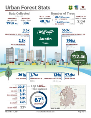
TOTAL LIVING Overall Tree Population 40.7M ± 4.7M Number of Trees 28.4M LIVE TREES 1.0” – 4.9” DIAMETER ± 4.4M 12.2M LIVE TREES 5.0”+ DIAMETER ± 787K TOTAL DEAD Standing, 1.0”+ diameter 2.0M ± 372K Urban Forest Stats Data Collected 2014 to 2022 SAMPLE AREA map at bottom right PLOT COUNT plot size = 1/6 acre 195K AC 304 CASES/YEAR NEGATIVE HEALTH EFFECTS AVOIDED 3.6K $12.2M / year 2.3K TONS/YEAR POLLUTION REMOVAL Austin Texas 563K $23.7M / year GIGAJOULES/YEAR REDUCED RESIDENTIAL ENERGY USE 196M CUBIC FEET/YEAR AVOIDED RUNOFF $13.1M / year $12.4B COMPENSATORY VALUE 361K TONS LEAF BIOMASS 1.7M TONS CARBON STORAGE TONS/YEAR CARBON ACCUMULATION $284M $23.2M / year 136K 97.6M CUBIC FEET WOOD VOLUME ASHE JUNIPER CEDAR ELM TEXAS PERSIMMON LIVE OAK SUGARBERRY 12M 30.2% 7.4M 18.1% 2.8M 6.9% 2.7M 6.8% 1.9M 4.6% 13.6M 33% 62 MORE SPECIES Top 5 MOST ABUNDANT Tree Species account for 67% of all LIVE TREES November 18, 2024 www.urbanforeststats.com Page 1 of 2 SAMPLE AREA Urban Forest Stats CONTINUED Austin’s Top 3 Tree Species LAND USE OWNERSHIP RESIDENTIAL OTHER DEVELOPED FOREST OTHER PUBLIC PRIVATE account for 14% of OTP account for 6% of OTP account for 80% of OTP account for <1% of OTP account for 55% of OTP account for 45% of OTP Cedar elm 775K Ashe juniper 630K Sugarberry 553K 5.75M TREES on 51.9K RESIDENTIAL AC Ashe juniper 410K Texas persimmon 287K Live oak 236K 2.46M TREES on 82.6K DEVELOPED AC Ashe juniper 11.2M Cedar elm 6.5M Texas persimmon 2.2M 32.4M TREES on 48.2K FOREST AC Ashe juniper 57K Honey mesquite 9.2K None — 66.5K TREES on 12.5K OTHER AC OVERALL TREE POPULATION DIAMETER (INCHES) Ashe juniper 6.3M Cedar elm 6.3M Texas persimmon 2.8M 28.4M Ashe juniper 4.2M Live oak 866K Cedar elm Ashe juniper 1.8M Live oak 687K Cedar elm Live oak 108K Ashe juniper 72K Pecan 743K 8.16M 348K 3.74M 19K 323K TREES with diameters 1.0” to 4.9” TREES with diameters 5.0” to 9.9” TREES with diameters 10.0” to 19.9” TREES with diameters 20.0” or greater Ashe juniper 7.3M Cedar elm 4.8M Chinese tallowtree 1.8M 22.3M TREES on 68.8K PUBLIC AC Ashe juniper 5.0M Cedar elm 2.5M Live oak 1.7M 18.3M TREES on 122.3K PRIVATE AC OVERALL TREE POPULATION MAINTAINED AREA Live oak 639K Sugarberry 603K Cedar elm 431K 4.59M TREES in areas MAINTAINED Ashe juniper 12.1M Cedar elm 6.9M Texas persimmon 2.6M 36.1M TREES in areas NOT MAINTAINED …
City of Austin & Open Government Partnership Presentation to Joint Inclusion Commission December 18, 2024 Special Called Meeting The Open Government Partnership In 2011, government leaders and civil society advocates came together to create a unique partnership - one that combines these powerful forces to promote transparent, participatory, inclusive, and accountable governance. The Open Government Partnership (OGP) is a multilateral initiative aimed at securing commitments from national and sub-national governments to promote open government, combat corruption, and improve governance. OGP By the Numbers 75 countries 104 local members 400+ action plans 5,000+ commitments 3 OGP Austin’s Origin Story OGP Austin Created City Council Resolution 20160225-017 confirmed the City of Austin’s interest in participating in the Open Government Partnership (OGP). 2017 2016 Action Plan Two Created Four commitments: ● ● ● ● Public Safety Data Transparency Inclusion in Court Contracting Community Housing Climate Resilience 2024 . 2019 Action Plan One Created Five commitments addressing: ● ● ● ● ● Homelessness An equity assessment tool Online information about city projects Better access to city council public meetings Inclusiveness in “smart city” processes Action Plan three Four inaugural commitments: ● ● ● ● Anticipatory governance & climate Economic resilience & workforce AI & accountability Enhanced equity assessments tools The OGP Action Plan Cycle 5 OPEN GOVERNMENT PARTNERSHIP 5 Approach ● ● Build on existing and emerging work rooted in robust community feedback Ensure a shared power analysis through equity training ● Apply a futures framework (strategic foresight) to ensure we are anticipating the needs of tomorrow Published Commitments Austin’s OGP Action Plan 2024-2028 🏛 AI accountability: Creating a framework to address bias, errors, and misuse in government AI tools with processes for evaluation, reporting, and resolution. 🌎 Climate adaptation: Developing a scalable process to adapt city operations to climate change, starting with a pilot program in partnership with Texas State University. ⚖ Economic resilience: Tackling economic inequality in the Eastern Crescent neighborhood through a cross-departmental team to support small businesses and guide policy through data. Commitments In development Austin’s OGP Action Plan 2024-2028 Equity Assessment Tool: Refine our internal equity assessment tools to ensure that the City of Austin is evaluating its programs, policies, and practices for impacts on our most marginalized residents, with the goal that everyone in our community has access to the resources and opportunities they need to thrive. ○ Holding on the publication of our Equity Plan commitment pending …
REGULAR MEETING of the ZONING AND PLATTING COMMISSION TUESDAY, DECEMBER 17, 2024, 6:00 PM AUSTIN CITY HALL, COUNCIL CHAMBERS, ROOM 1001 301 WEST 2ND STREET AUSTIN, TEXAS Some members of the Zoning and Platting Commission may be participating by videoconference. The meeting may be viewed online at: http://www.austintexas.gov/page/watch-atxn-live. Public comment will be allowed in-person or remotely via telephone. Speakers may only register to speak on an item once either in-person or remotely. Registration no later than 2 PM the day of the meeting is required for remote participation by telephone. For more information on public comment, please see the agenda section “Speaker Registration”. Please contact Ella Garcia, Staff Liaison, for questions regarding speaker registration at LandUseLiaison@austintexas.gov or by phone at 512-978-0821. CURRENT BOARD MEMBERS/COMMISSIONERS: Hank Smith – Chair (District 8) Betsy Greenberg – Vice-Chair (District 6) Carrie Thompson – Secretary (District 10) Alejandra Flores – Parliamentarian (District 5) Lonny Stern (District 3) Scott Boone (District 1) Felix De Portu (District 4) Taylor Major (District 9) David Fouts (District 2) William D. Floyd (Mayor’s Representative) Ryan Puzycki (District 7) EXECUTIVE SESSION (No public discussion) The Zoning and Platting Commission will announce it will go into Executive Session, if necessary, pursuant to Chapter 551 of the Texas Government Code, to receive advice from Legal Counsel on matters specifically listed on this agenda. The commission may not conduct a closed meeting without the approval of the city attorney. Private Consultation with Attorney – Section 551.071 AGENDA Executive Liaison: Joi Harden, 512-974-1617 Staff Liaison: Ella Garcia, 512-978-0821 Attorney: AJ Urteaga, 512-974-2386 CALL TO ORDER PUBLIC COMMUNICATION: GENERAL The first four speakers signed up prior to the meeting being called to order will each be allowed a three-minute allotment to address their concerns regarding items not posted on the agenda. APPROVAL OF MINUTES 1. Approve the minutes of the Zoning and Platting Commission regular meeting on December 3, 2024. PUBLIC HEARINGS C14-2024-0118.SH - 8301 Riverstone; District 1 8301 Riverstone Drive, Elm Creek Watershed 2. Rezoning: Location: Owner/Applicant: 8301 Riverstone LP Agent: Request: Staff Rec.: Staff: Austin Revitalization Authority (Bryan Kight) MF-2 to SF-3 Applicant postponement request to January 21, 2025 Jonathan Tomko, 512-974-1057, jonathan.tomko@austintexas.gov Planning Department 3. Rezoning: Location: C14-2024-0092 - Allred, Riddle, and W. Slaughter; District 5 2205, 2207, & 2200 Riddle Road; 2200, 2202, 2104, 2106, 2108, & 2206 Allred Drive; 2105, 2107, & 2109 West Slaughter Lane, Slaughter Creek Watershed Owner/Applicant: 2106 …
Outlook RE: Re-zoning Case 8301 Riverstone (C14-2024-0118.SH) From Bryan Kight < > Date Wed 12/11/2024 12:01 PM To Tomko, Jonathan < >; Trinity White < > External Email - Exercise Caution Hi Jonathan, Per our phone call and my email sent to you earlier this morning, we’re choosing to postpone the hearing and come to an agreement with AFD before we go to ZAP. I conferred with Greg, our CEO, and he agrees with you and I that choosing the hearing date of 01/21/25 is the best option for us. This will give us more time to come eye-to-eye with AFD. Thank you for the helpful phone call and feel free to reach me at 512.469.1705 or 832.332.6478 should there be anything else that’s pressing. Bryan Kight Project Manager | Austin Revitalization Authority 02 C14-2024-0118.SH - 8301 Riverstone; District 11 of 1
************************************************************************ MEMORANDUM TO: Hank Smith, Chair Zoning and Platting Commission Members FROM: Nancy Estrada, Principal Planner Planning Department DATE: December 10, 2024 RE: C14-2024-0092 – Allred, Riddle, and W. Slaughter Request for Indefinite Postponement by Staff ************************************************************************ Staff requests an indefinite postponement of the above referenced rezoning case. Staff is anticipating receipt of a revised rezoning request as well as additional information about the proposed development. As information, per LDC 25-2-246 (A) (2) (Expiration of Application), a rezoning application will expire if it is not scheduled for a public hearing before the 181st day after the date on which the land use commission grants an indefinite postponement of a scheduled public hearing. Renotification of the rezoning case will be required in order to reschedule the public hearing. Attachments: Zoning Map Applicant Correspondence 03 C14-2024-0092 - Allred, Riddle, and W. Slaughter; District 51 of 3 RR ( ( ( ( SF-3 ( ( ( ( ( ( ( ( ( ( ( ( ( ( ( ( C R A N B R O O K C V ( ( ( ( ( ( SF-2 P I P I N G R O C ( ( ( ( SF-2 K T R L ( ( ( ( ( SF-1 ( ( ( ( SF-2 ( ( ( ( ( ( SF-4A ( ( ( ( ( ( ( ( > 980326-L > SF-1 > SF-3 > > 980326-L ( ( ( ( SF-2 ( ( ( ( SF-4A ( SF-2 ( SF-4A ( SF-2 ( SF-4A ( ( SF-4A ( SF-2 ( ( SF-4A ( SF-2 ( SF-4A ( ( Y A W S R E L L I W ( ( ( ( ( SF-4A ( I R D E G D R R A R B I ( ( ( ( ( ( I R D E R H S D O O W SF-2 ( ( ( ( ( ( SF-1 ( ( ( ( ( ( ( ( ( ( SF-2 ( ( SF-4A ( ( ( ( ( ( ( ( ( ( ( ( ( SF-1 ( ( ( ( ( ( ( ( ( ( SF-2 ( ( ( ( ( ( ( ( > > > > > > 980326-L ( = = = > > > > = = = ( D AIL R G ( ( SF-2 = = = = …
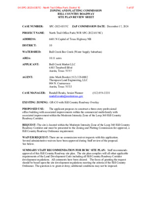
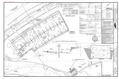
ZONING AND PLATTING COMMISSION HILL COUNTRY ROADWAY SITE PLAN REVIEW SHEET CASE NUMBER: SPC-2023-0357C ZAP COMMISSION DATE: December 17, 2024 PROJECT NAME: North Trail Office Park (W/R SPC-2022-0170C) ADDRESS: 6601 N Capital of Texas Highway NB DISTRICT: 10 WATERSHED: Bull Creek Bee Creek (Water Supply Suburban) AREA: 10.11 acres APPLICANT: Bull Creek Market LLC 6503 Treadwell Blvd Austin, Texas 78757 AGENT: Attn: Mark Roeder (512) 328-0002 Thompson Land Engineering, LLC 904 N. Cuernavaca Austin, Texas 78733 CASE MANAGER: Randall Rouda, Senior Planner (512) 974-3338 randall.rouda@austintexas.gov EXISTING ZONING: GR-CO with Hill Country Roadway Overlay The applicant proposes to construct a three-story professional PROPOSED USE: office building with associated improvements within the commercial multi-family with associated improvement within the Moderate Intensity Zone of the Loop 360 Hill Country Roadway Corridor. REQUEST: The site is located within the Moderate Intensity Zone of the Loop 360 Hill Country Roadway Corridor and must be presented to the Zoning and Platting Commission for approval, a Hill Country Roadway Ordinance requirement. WAIVER REQUEST: There are no commission waiver requests with this application. Several administrative waivers have been approved during Staff review of the proposal. See below. SUMMARY STAFF RECOMMENDATION FOR HCRC SITE PLAN: Staff recommends approval of this Hill Country Roadway site plan. The site plan complies will all other applicable requirements of the Land Development Code including all Hill Country Roadway Corridor development regulations. All comments have been cleared. The focus of granting the request should be based upon the site development regulations meeting the criteria of the Hill Country Ordinance. The question is to grant or deny; additional conditions may not be imposed. 04 SPC-2023-0357C - North Trail Office Park; District 101 of 57 ZONING AND PLATTING COMMISSION ACTION: Postponed to December 3, 2024, following discussion, and to December 17, 2024. LEGAL DESCRIPTION: 10.112ac of Lot 1, Block A of the Champion 360 Subdivision, Travis County, Texas, according to the Deed Recorded in Document #2023038947 EXIST. ZONING: GR-CO ALLOWED F.A.R.: 1:1 ALLOWED HEIGHT: 28’ MAX. BLDG. COVERAGE: 75% MAX. IMPERV. CVRG.: 90% MIN. REQ. HC NATURAL AREA: 4 ac (40%) PROVIDED: 5.6 ac (56%) REQUIRED PARKING: 0 CONDITIONAL OVERLAY ZONING REQUIREMENTS This site is subject to additional conditions per Ordinance No. 050113-69. They are: PROPOSED USE: Professional Office PROPOSED F.A.R.: 0.26:1 PROPOSED HEIGHT: 28’ PROPOSED BLDG. CVRG: 8.6% PROPOSED IMP. CVRG.: 15.5% PROPOSED PARKING:464 • 75-foot Bluff Setback • 50-foot Vegetative Buffer • No access …
(cid:55)(cid:75)(cid:82)(cid:80)(cid:83)(cid:86)(cid:82)(cid:81) (cid:47)(cid:68)(cid:81)(cid:71) (cid:40)(cid:81)(cid:74)(cid:76)(cid:81)(cid:72)(cid:72)(cid:85)(cid:76)(cid:81)(cid:74)(cid:15) (cid:47)(cid:47)(cid:38) (cid:11)(cid:41)(cid:16)(cid:20)(cid:19)(cid:21)(cid:21)(cid:19)(cid:12) 04 SPC-2023-0357C - North Trail Office Park; District 1010 of 57 (cid:55)(cid:75)(cid:82)(cid:80)(cid:83)(cid:86)(cid:82)(cid:81) (cid:47)(cid:68)(cid:81)(cid:71) (cid:40)(cid:81)(cid:74)(cid:76)(cid:81)(cid:72)(cid:72)(cid:85)(cid:76)(cid:81)(cid:74)(cid:15) (cid:47)(cid:47)(cid:38) (cid:11)(cid:41)(cid:16)(cid:20)(cid:19)(cid:21)(cid:21)(cid:19)(cid:12) 04 SPC-2023-0357C - North Trail Office Park; District 1011 of 57 (cid:55)(cid:75)(cid:82)(cid:80)(cid:83)(cid:86)(cid:82)(cid:81) (cid:47)(cid:68)(cid:81)(cid:71) (cid:40)(cid:81)(cid:74)(cid:76)(cid:81)(cid:72)(cid:72)(cid:85)(cid:76)(cid:81)(cid:74)(cid:15) (cid:47)(cid:47)(cid:38) (cid:11)(cid:41)(cid:16)(cid:20)(cid:19)(cid:21)(cid:21)(cid:19)(cid:12) 04 SPC-2023-0357C - North Trail Office Park; District 1012 of 57 (cid:55)(cid:75)(cid:82)(cid:80)(cid:83)(cid:86)(cid:82)(cid:81) (cid:47)(cid:68)(cid:81)(cid:71) (cid:40)(cid:81)(cid:74)(cid:76)(cid:81)(cid:72)(cid:72)(cid:85)(cid:76)(cid:81)(cid:74)(cid:15) (cid:47)(cid:47)(cid:38) (cid:11)(cid:41)(cid:16)(cid:20)(cid:19)(cid:21)(cid:21)(cid:19)(cid:12) 04 SPC-2023-0357C - North Trail Office Park; District 1013 of 57 (cid:55)(cid:75)(cid:82)(cid:80)(cid:83)(cid:86)(cid:82)(cid:81) (cid:47)(cid:68)(cid:81)(cid:71) (cid:40)(cid:81)(cid:74)(cid:76)(cid:81)(cid:72)(cid:72)(cid:85)(cid:76)(cid:81)(cid:74)(cid:15) (cid:47)(cid:47)(cid:38) (cid:11)(cid:41)(cid:16)(cid:20)(cid:19)(cid:21)(cid:21)(cid:19)(cid:12) 04 SPC-2023-0357C - North Trail Office Park; District 1014 of 57 Appliances, Appurtenances, or Fixtures Drinking Fountain or Water Cooler Hose Bibb, each additional Hose Bibb Lavoratory Kitchen, domestic (sink) Urinal, greater than 1.0 GPF Flushometer Valve Water Closet, greater than 1.6 GPF Gravity Tank Taken from the 2015 UPC Calcs (Table 610.3) BUILDING #1 Fixture Count Water Supply Fixture Units Water Supply Fixture Units (WSFU) 0.5 Total Fixtures Units = Gallons per Minute, GPM (Chart A 2.1, using 200 fixture units) = 63 Line Size (inches) = 2.3 (@ 5 fps) Line Velocity (fps) = 5.0 (max.) Line Length (feet) = Line Loss (psi) = 50.0 0.9 Minimum Water Meter Size (@15 fps) = 1.3 inch WM Size per AWWA Operating Characteristics = 1.50 inch Taken from the 2015 UPC Calcs (Table 702.1) Drainage Fixture Units (DFU) BUILDING #1 Fixture Count Drainage Fixture Units Total Project Fixture Fixture Count Units 2.5 1.5 1 1 4 3 0.5 1 2 2 4 6 1 7 18 6 12 36 6 18 6 12 36 3.0 2.5 7.0 18.0 9.0 48.0 108.0 195.5 3.0 18.0 12.0 24.0 144.0 Total Project Fixture Fixture Units Count 3.0 6 1 7 18 6 12 36 86 2.5 7.0 18.0 9.0 48.0 108.0 196 6 18 6 12 36 78 3.0 18.0 12.0 24.0 144.0 201 4 5 3.4 65.6 Design Slope: 2.0% Total Fixtures = UPC Line Size (inches) Table 7-5 @ 2% = UPC Line Size (inches) Table 7-5 @ 1% = Velocity at half-full and design slope (fps) = Flow at half-full and design slope (gpm) = Appliances, Appurtenances, or Fixtures Drinking Fountain or Water Cooler Lavatory, single Kitchen, domestic, with or without food grinder (sink) Urinal,integral trap greater than 1.0 GPF Water Closet, greater than 1.6 GPF Gravity Tank (cid:55)(cid:75)(cid:82)(cid:80)(cid:83)(cid:86)(cid:82)(cid:81) (cid:47)(cid:68)(cid:81)(cid:71) (cid:40)(cid:81)(cid:74)(cid:76)(cid:81)(cid:72)(cid:72)(cid:85)(cid:76)(cid:81)(cid:74)(cid:15) (cid:47)(cid:47)(cid:38) (cid:11)(cid:41)(cid:16)(cid:20)(cid:19)(cid:21)(cid:21)(cid:19)(cid:12) 04 SPC-2023-0357C - North Trail Office Park; District 1015 of 57 (cid:55)(cid:75)(cid:82)(cid:80)(cid:83)(cid:86)(cid:82)(cid:81) (cid:47)(cid:68)(cid:81)(cid:71) (cid:40)(cid:81)(cid:74)(cid:76)(cid:81)(cid:72)(cid:72)(cid:85)(cid:76)(cid:81)(cid:74)(cid:15) (cid:47)(cid:47)(cid:38) (cid:11)(cid:41)(cid:16)(cid:20)(cid:19)(cid:21)(cid:21)(cid:19)(cid:12) 04 SPC-2023-0357C - North Trail Office Park; District 1016 of 57
APPENDIX Q-1 NET SITE AREA APPENDIX Q-2 IMPERVIOUS COVER NOTE: NET SITE AREA IS ONLY APPLICABLE TO WATERSHEDS CLASSIFIED AS WATER SUPPLY SUBURBAN / WATER SUPPLY RURAL / BARTON SPRINGS ZONE WATER SUPPLY SUBURBAN / WATER SUPPLY RURAL / BARTON SPRINGS ZONE WATER QUALITY TRANSITION ZONE Total Gross Site Area = 10.11 Acres WATER QUALITY TRANSITION ZONE OUTSIDE OF 100-YEAR FLOODPLAIN (NON-FP WQTZ) = 0.00 ACRES (cid:55)(cid:75)(cid:82)(cid:80)(cid:83)(cid:86)(cid:82)(cid:81) (cid:47)(cid:68)(cid:81)(cid:71) (cid:40)(cid:81)(cid:74)(cid:76)(cid:81)(cid:72)(cid:72)(cid:85)(cid:76)(cid:81)(cid:74)(cid:15) (cid:47)(cid:47)(cid:38) (cid:11)(cid:41)(cid:16)(cid:20)(cid:19)(cid:21)(cid:21)(cid:19)(cid:12) Site Deductions (not applicable per Compromise Settlement Agreement): Critical water quality zone (CWQZ) = Water quality transition zone (WQTZ) = Wastewater irrigation areas = Deduction subtotal = 0.00 Acres 0.00 Acres 0.00 Acres 0.00 Acres Upland area (gross area minus total deductions) = 10.11 Acres Net Site Area Calculation (updated per 1984 Lake Austin Watershed rules): Area of Uplands with Slopes 0-15% Area of Uplands with Slopes 15-25% Area of Uplands with Slopes 25-35% Area of Uplands with Slopes > 35% Net Site Area (subtotal) = 5.54 2.25 0.61 1.71 10.11 Acres Slope Categories 0-15 15-25 25-35 35+ Total = Building Gross Floor Area (GFA) Floor to Area Ratio (FAR) [square feet] 95,393 15,176 1,096 1,184 112,848 [acres] 2.19 0.35 0.03 0.03 2.59 0.217 :1 0.034 :1 0.002 :1 0.003 :1 0.256 :1 ALLOWABLE IMPERVIOUS COVER (these are updated per 1984 Lake Austin Watershed rules): * Sec. 9-10-384. Commercial Development. (a) (1) Fifty (50) percent impervious cover on slopes under fifteen (15) percent gradient; (a) (2) Fifteen (15) percent impervious cover on slopes of fifteen (15) to twenty-five (25) percent gradient; (a) (3) Five (5) percent impervious cover on slopes of over twenty-five (25) and up to thirty-five (35) percent gradient; IMPERVIOUS COVER ALLOWED AT ** IMPERVIOUS COVER ALLOWED AT 0% 31.0% x NON-FP WQTZ = x NET SITE AREA = 0.00 3.14 ACRES ACRES * * Allowable IC per Sec. 9-10-384 = [ (50%)*(5.54) + (15%)*(2.250)+(5%)*(0.61) ] = 3.14 ** Percentage is the Allowable IC divided by NSA = [(3.14) / (10.11)] * 100% = 31.0% TOTAL IMPERVIOUS COVER ALLOWED = 3.14 ACRES ALLOWABLE IMPERVIOUS COVER BREAKDOWN BY SLOPE CATEGORY Total acreage 15-25% = 2.25 x 10% = 0.23 PROPOSED TOTAL IMPERVIOUS COVER IMPERVIOUS COVER IN NON-FP WQTZ = IMPERVIOUS COVER IN UPLANDS ZONE = 0.00 1.51 Acres = Acres = 0.0% 15.0% TOTAL PROPOSED IMPERVIOUS COVER = 1.51 Acres PROPOSED IMPERVIOUS COVER ON SLOPES Slope Categories 0-15% 15-25% 25-35% > 35% Acres 5.54 2.25 0.61 1.71 Total …
(cid:17)(cid:437)(cid:349)(cid:367)(cid:282)(cid:349)(cid:374)(cid:336)(cid:3)(cid:24)(cid:258)(cid:410)(cid:258)(cid:3)(cid:100)(cid:258)(cid:271)(cid:367)(cid:286)(cid:855) (cid:17)(cid:437)(cid:349)(cid:367)(cid:282)(cid:349)(cid:374)(cid:336) (cid:4) (cid:100)(cid:381)(cid:410)(cid:258)(cid:367)(cid:3)(cid:39)(cid:38)(cid:4)(cid:855) (cid:100)(cid:381)(cid:410)(cid:258)(cid:367)(cid:3)(cid:39)(cid:38)(cid:4)(cid:855) (cid:39)(cid:396)(cid:381)(cid:400)(cid:400)(cid:3)(cid:38)(cid:367)(cid:381)(cid:381)(cid:396)(cid:3)(cid:4)(cid:396)(cid:286)(cid:258)(cid:3) (cid:894)(cid:39)(cid:38)(cid:4)(cid:895)(cid:853)(cid:3)(cid:400)(cid:395)(cid:437)(cid:258)(cid:396)(cid:286)(cid:3)(cid:296)(cid:286)(cid:286)(cid:410) (cid:1005)(cid:1005)(cid:1007)(cid:853)(cid:1005)(cid:1013)(cid:1010) (cid:1005)(cid:1005)(cid:1007)(cid:853)(cid:1005)(cid:1013)(cid:1010) (cid:1005)(cid:1009)(cid:1004)(cid:853)(cid:1013)(cid:1006)(cid:1012) (cid:1006)(cid:1010)(cid:1008)(cid:853)(cid:1005)(cid:1006)(cid:1007) (cid:1005)(cid:1005)(cid:1007)(cid:853)(cid:1005)(cid:1013)(cid:1010) (cid:87)(cid:396)(cid:381)(cid:393)(cid:381)(cid:400)(cid:286)(cid:282)(cid:3)(cid:104)(cid:400)(cid:286) (cid:17)(cid:437)(cid:349)(cid:367)(cid:282)(cid:349)(cid:374)(cid:336)(cid:3)(cid:44)(cid:286)(cid:349)(cid:336)(cid:346)(cid:410) (cid:38)(cid:381)(cid:437)(cid:374)(cid:282)(cid:258)(cid:410)(cid:349)(cid:381)(cid:374)(cid:3)(cid:100)(cid:455)(cid:393)(cid:286) (cid:894)(cid:400)(cid:286)(cid:286)(cid:3)(cid:271)(cid:286)(cid:367)(cid:381)(cid:449)(cid:895) (cid:87)(cid:396)(cid:381)(cid:296)(cid:286)(cid:400)(cid:400)(cid:349)(cid:381)(cid:374)(cid:258)(cid:367)(cid:3)(cid:75)(cid:296)(cid:296)(cid:349)(cid:272)(cid:286)(cid:400) (cid:87)(cid:258)(cid:396)(cid:364)(cid:349)(cid:374)(cid:336)(cid:3)(cid:39)(cid:258)(cid:396)(cid:258)(cid:336)(cid:286) (cid:1006)(cid:1012)(cid:882)(cid:296)(cid:286)(cid:286)(cid:410) (cid:18)(cid:381)(cid:374)(cid:272)(cid:396)(cid:286)(cid:410)(cid:286)(cid:3)(cid:87)(cid:381)(cid:282)(cid:349)(cid:437)(cid:373) (cid:894)(cid:1006)(cid:882)(cid:400)(cid:410)(cid:381)(cid:396)(cid:349)(cid:286)(cid:400)(cid:3)(cid:258)(cid:271)(cid:381)(cid:448)(cid:286)(cid:3)(cid:920)(cid:3)(cid:1005)(cid:882)(cid:400)(cid:410)(cid:381)(cid:396)(cid:455)(cid:3)(cid:271)(cid:286)(cid:367)(cid:381)(cid:449)(cid:3)(cid:336)(cid:396)(cid:381)(cid:437)(cid:374)(cid:282)(cid:895) (cid:894)(cid:1008)(cid:882)(cid:367)(cid:286)(cid:448)(cid:286)(cid:367)(cid:400)(cid:3)(cid:271)(cid:286)(cid:367)(cid:381)(cid:449)(cid:3)(cid:336)(cid:396)(cid:381)(cid:437)(cid:374)(cid:282)(cid:895) (cid:894)(cid:296)(cid:381)(cid:396)(cid:3)(cid:4)(cid:38)(cid:24)(cid:3)(cid:393)(cid:437)(cid:396)(cid:393)(cid:381)(cid:400)(cid:286)(cid:400)(cid:895) (cid:894)(cid:296)(cid:381)(cid:396)(cid:3)(cid:4)(cid:116)(cid:853)(cid:3)(cid:87)(cid:4)(cid:90)(cid:24)(cid:3)(cid:920)(cid:3)(cid:127)(cid:381)(cid:374)(cid:349)(cid:374)(cid:336)(cid:3)(cid:393)(cid:437)(cid:396)(cid:393)(cid:381)(cid:400)(cid:286)(cid:400)(cid:853)(cid:3)(cid:286)(cid:454)(cid:272)(cid:367)(cid:437)(cid:282)(cid:286)(cid:400)(cid:3)(cid:393)(cid:258)(cid:396)(cid:364)(cid:349)(cid:374)(cid:336)(cid:3)(cid:400)(cid:410)(cid:396)(cid:437)(cid:272)(cid:410)(cid:437)(cid:396)(cid:286)(cid:895) (cid:38)(cid:349)(cid:374)(cid:349)(cid:400)(cid:346)(cid:286)(cid:282)(cid:3)(cid:38)(cid:367)(cid:381)(cid:381)(cid:396)(cid:3) (cid:28)(cid:367)(cid:286)(cid:448)(cid:258)(cid:410)(cid:349)(cid:381)(cid:374)(cid:3)(cid:894)(cid:38)(cid:38)(cid:28)(cid:895) (cid:1010)(cid:1007)(cid:1009)(cid:856)(cid:1009) Total Site Area: Site Development Calculations 440,505 sf 10.11 ac BUILDING UNIT GAR1 GAR2 GAR3 101 201 304 401 Total Floor Level 1 2 3 4 5 6 7 Square Footage 37,732 37,732 37,732 37,732 37,732 37,732 37,732 264,123 ADDRESS & Street Name 6601 N CAPITAL OF TEXAS HWY NB 6601 N CAPITAL OF TEXAS HWY NB 6601 N CAPITAL OF TEXAS HWY NB 6601 N CAPITAL OF TEXAS HWY NB 6601 N CAPITAL OF TEXAS HWY NB 6601 N CAPITAL OF TEXAS HWY NB 6601 N CAPITAL OF TEXAS HWY NB Zoning Site Area (sf) (ac) Private Common Open Space (sf) (%) Impervious Cover (sf) (ac) (%) Total Building Coverage Area (sf) (%) Total Building Floor Area (sf) Total Floor to Area Ratio (FAR) Total Building Height (feet) Total Building Height (stories) Existing GR-CO 440,505 10.11 -- -- 0 0.00 0.0% 0 0.0% 0 0:1 0.0 0 Allow / Required sf = 5.0% GSA (min.) 5,750-SF 22,025 Proposed GR-CO 440,505 10.11 25,000 5.7% 68,307 1.57 15.5% 90.0% 37,732 8.6% 113,196 0.26:1 75.0% see building sections; 28' (max.) per settlement agreement IC items: -------------- - Bldgs - Drive aisle and parking - Sidewalk Pavement Impervious Cover (IC) Summary (This Site Plan only) Total Existing IC Area (sf) -------------- 0 0 0 0 % -------------- 0.0% 0.0% 0.0% 0.0% Existing to be Removed -------------- 0 0 0 0 Proposed to be Added -------------- 37,732 25,736 4,839 68,307 Total Proposed IC Area (sf) -------------- 37,732 25,736 4,839 68,307 % -------------- 8.6% 5.8% 1.1% 15.5% Total IC = Total IC (acres) = 0.00 1.57 1.57 Parking Summary Required / Allowed Proposed See below See below Type Parking Totals - Total - Total (Standard) - uncovered/outside - Total (Accessible per IBC table 1106.1) - Total (Standard) - in garage - Total (Accessible per IBC table 1106.1) - Total (Compact) - Total Bicycle Parking - Short Term Bicycle Parking Spaces - Long Term Bicycle Parking Spaces - Total Loading zone 412.0 -- 2.0 -- 6.0 123.6 14% 86% 1 (30% compact allowed per COA LDC 25-6-477) 41 (10% vehicle spaces) 464 18 2 376 16 52 42 6 36 1 Required Parking Business & Professional Offices * SF ------------- 113,196 Employees ------------- - Required* ------------- 412.0 Proposed ------------ …