Austin Public Health 2012 and 2018 Bond Projects Update May 2025 Filip Gecic, Austin Public Health Kalpana Sutaria, Capital Services Delivery Agenda • Department Overview • APH Bond Funding History • APH Completed Projects Austin Public Health: The Heart Mission: To prevent disease, promote health, and protect the well-being of all. Low-cost vaccinations Health screenings Infant & maternal health Birth and death certificates Diabetes education and prevention classes Food truck, restaurants, pool and water feature inspections Mosquito testing and abatement Rent assistance, food pantries, job application support Austin Public Health: Centers of Service Mission:To prevent disease, promote health, and protect the well-being of all. 14 WIC Clinics 6 Neighborhood Centers 2 Shots for Tots and Big Shots Clinics + Weekly Mobile Clinics Sexual Health Clinic Refugee Services Clinic Mom's Place Lactation Support Center Office of Vital Records Bond History- Austin Public Health • Austin Public Health has received less than 1% of the City Bond Appropriation since 1998. Voters Authorized Bond Election Year Sum of APH Appropriation 1998 2000 2006 2010 2012 2013 2016 2018 2020 2022 $339,740,000 $163,400,000 $567,400,000 $90,000 $306,648,000 $65,000,000 $720,000,000 $925,000,000 $460,000,000 $350,000,000 $11,148,000 $16,000,000 Grand Totals $3,897,278,000 $27,148,000 Bond Appropriated Funds (1998 – 2022) Blue Shaded Area - $3,897,278,000 All other city departments. Orange Shaded Area - $27,148,000 Austin Public Health Funding Less than 1% APH Projects Completed With Past Bond Funding *Dove Springs Health Center *Montopolis Recreation Public Health Center *Women’s & Children’s Center *Betty Dunkerly & Animal Center Improvements *Parking Expansion at 2 APH sites 2012 Bond Projects • Parking Lot Expansion at Far South and Montopolis APH Sites (2016) • Betty Dunkerley Campus Infrastructure Improvements / Animal Center Kennel Addition (2017) • Women and Children’s Shelter Repairs and Expansion (2018) • Montopolis Recreation and Community Center - Joint Project with Parks and Recreation Department (2020) 2012 Proposition 17 Austin Public Health BOND BALANCES Voter-approved $11,145,000 Appropriated $11,145,000 Encumbered $26,658 Spent $11,082,260 Committed $11,108,918 Available Data thru Q4 FY 2024 $36,082 Parking Lot Expansion Project Scope Parking expansion at two APH Sites Drainage management Landscaping Budget $906,000 – constructed in-house by PWD Far South – Existing 21 parking spaces, 19 added, new total 40 Montopolis – Existing 13 parking spaces, 13 added, new total 26 Status – Completed in 2016 Parking Lot Expansions Betty Dunkerley Campus Project Scope Resolve drainage issues Improve campus road Construct additional sidewalks and trails Expand …
ENVIRONMENTAL COMMISSION REGULAR CALLED MEETING MINUTES Wednesday, May 21, 2025 The Environmental Commission convened in a Regular meeting on Wednesday, May 21, 2025, at 6310 Wilhelmina Delco Drive in Austin, Texas. Vice Chair Krueger called the Environmental Commission Meeting to order at 6:01 p.m. Commissioners in Attendance: Mariana Krueger, Richard Brimer, Annie Fierro, Ashika Ganguly, Martin Luecke, Haris Qureshi, David Sullivan Commissioners in Attendance Remotely: Isabella Changsut Commissioners Absent: Jennifer Bristol, Hanna Cofer, Justin Fleury PUBLIC COMMUNICATION: GENERAL None APPROVAL OF MINUTES 1. Approve the minutes of the Environmental Commission Regular Meeting on May 7, 2025 The minutes of the Environmental Commission Regular Meeting on May 7, 2025, were approved on Commissioner Brimer’s motion, Commissioner Qureshi’s second on a 7-0 vote. Commissioners Bristol, Cofer, and Fleury were absent. Commissioner Ganguly was off the dais. PUBLIC HEARINGS 2. Name: Camelback PUD Amendment #3, C814-86-023.01 Applicant: Armbrust & Brown, L.L.P (Amanda Morrow) Location: 6505 Bridge Point Parkway, Austin, TX 78730 Council District: District 10 Staff: Leslie Lilly, Environmental Conservation Program Manager, (512) 535-8914, Leslie.lilly@austintexas.gov; Sean Watson, Environmental Program Coordinator, (512) 963-2167, Sean.Watson@austintexas.gov Applicant request: Amend a Planned Unit Development Staff Recommendation: Staff recommended with conditions 1 Speakers: Sean Watson, WPD Johnathon Coons, Applicant Leslie Lilly, WPD Allison __ , Kimley-Horn Naomi Rotramel, City Arborist, DSD A motion to close the public hearing passed on Commissioner Sullivan’s motion, Commissioner Brimer’s second, on a 10–0 vote. Commissioners Bristol, Cofer, and Fleury was absent. A motion to recommend the Camelback PUD Amendment #3 with conditions passed on Commissioner Krueger’s motion, Commissioner Sullivan’s second, on a 8–0 vote. Commissioners Bristol, Cofer, and Fleury was absent. DISCUSSION ITEMS 3. Presentation and discussion on Austin Resource Recovery’s Road to Zero Waste – Ron Romero, Assistant Director, Austin Resource Recovery Item conducted as posted. No action taken. FUTURE AGENDA ITEMS None ADJOURNMENT Vice Chair Krueger adjourned the meeting at 7:51 pm without objection. The minutes were approved at the June 4, 2025 meeting on Commissioner Cofer’s motion, Commissioner Brimer’s second on a 9-0 vote. Commissioners Krueger and Ganguly were absent. 2
Commission Recommendation Economic Prosperity Commission Recommendation 20250521-003: Language Access Programs for Entrepreneurs WHEREAS the City of Austin has demonstrated a commitment to fostering economic and community potential by supporting underrepresented entrepreneurs, including women and minority business owners, through initiatives that reduce economic exclusion and bolster job creation; WHEREAS individuals with Limited English Proficiency (LEP), defined by the federal government as those who do not speak English as their primary language and have limited ability to read, speak, write, or understand English, comprise 10% of Austin's population; WHEREAS 24% of all new Austin businesses are founded by immigrants, who are 24.1% more likely to start a business than U.S.-born residents; WHEREAS 15% of Austin businesses are owned by immigrants, reflecting the city's cultural and economic diversity. Despite their entrepreneurial drive, LEP business owners face significant barriers in navigating regulatory processes, securing funding, and accessing critical business resources; WHEREAS Council Resolution 20131017-038 (2013) directed the City Manager to establish a universal translation and interpretation service protocol, culminating in the 2022 Language Access Policy. However, this policy primarily serves individuals rather than addressing the distinct needs of LEP business owners; WHEREAS Title VI of the Civil Rights Act of 1964 prohibits discrimination based on race, color, or national origin in federally funded programs, underscoring the importance of equitable access to city resources for all entrepreneurs; WHEREAS immigrant entrepreneurs, who constitute 18% of Austin’s population, are twice as likely to be self-employed but face higher business failure rates due to language barriers, limited professional networks, and lack of access to capital and regulatory information; WHEREAS investing in Limited English Proficiency entrepreneurs strengthens Austin’s economy, increases resilience during economic downturns, expands the tax base, and creates jobs; WHEREAS the Economic Development Department’s Community Navigator Program, which provided critical business support services, ended in December 2024, leaving a gap in resources for immigrant business owners; WHEREAS popular programs for English-speaking entrepreneurs, such as the BizAid Business Orientation, have not been offered in Spanish in the past 12 months due to a lack of awareness among existing and new limited english proficiency businesses. BizAid Business is an introductory class designed to equip aspiring business owners with the knowledge and resources needed to navigate the complex landscape of city, state, and federal regulations, as well as gain insights into the City of Austin's development process for commercial properties; WHEREAS immigrant-owned businesses in Texas employ over 635,000 workers and …
ECONOMIC PROSPERITY COMMISSION RECOMMENDATION 20250521-004 Date: May 21, 2025 Subject: City’s FY 2025 – 2026 Budget Motioned By: Chair Nahas Seconded By: Commissioner Pleuthner Recommendation The Budget of the City of Austin should respect renters as the equal of homeowners. Description of Recommendation to Council Require that the City of Austin 2025-26 Budget respect renters as "Typical" residents of Austin. Require that the City of Austin 2025-26 Budget's "Taxpayer Impact Statement" add a line for the average tax per rental unit, which includes the property tax and all other taxes and annual fees on rental properties. Require that the City of Austin 2025-26 Budget's "Taxpayer Impact Statement" rename the line "TOTAL YEARLY IMPACT" to "TOTAL YEARLY IMPACT (homeowner)" and add a line for "TOTAL YEARLY IMPACT (renter)", which includes the average taxes and fees paid per rental unit. Require that the City of Austin 2025-26 Budget's "Taxpayer Impact Statement" include a calculation of "TOTAL YEARLY IMPACT (renter)" for the previous budget, Fiscal Year 2023- 24, and compute a percentage increase from Fiscal Year 2023-24 to Fiscal Year 2025-26. Require that the City of Austin 2025-26 Budget's "Taxpayer Impact Statement" use the bottom half of the page to hold a table of "TOTAL YEARLY IMPACT" for Austin residents at all income levels. Rows should be by household income for every 10th percentile, from bottom 10% to top 10%. City Staff should estimate what proportion of each income bracket are homeowners and renters and assign an average (mathematical mean) property tax weighted by that proportion, based on properties that income bracket would rent or own. City Staff may have more detailed knowledge. They should investigate if residents in the bottom 10th percentile of income uses the average (mathematical mean) of the bottom 10th percentile of residential Austin Energy usage, residential Austin Water usage, etc.. Rationale: The City of Austin 2024-25 Budget's “Taxpayer Impact Statement” refers to a ““Typical” Resident Ratepayer” who pays property tax with a homestead exemption and, therefore, must be a homeowner. The 2024-25 budget claims that this “Typical” Austin resident owns a house worth $524,082. 1 of 2 In fact, the City of Austin actually has a majority of renters. The U.S. Census Bureau for the time period 2017-2021 reports that only 44.7% of the housing units in Austin are owner-occupied. A household owning a property worth $524,082 is likely in the top 25th percentile of income for the …
Bond Oversight Commission REGULAR CALLED MEETING MINUTES WEDNESDAY, May 21, 2025 The Bond Oversight Commission convened in a Regular meeting on Wednesday, May 21, 2025, at 301 W. 2nd Street in Austin, Texas. Acting Chair Charles Curry called the Bond Oversight Meeting to order at 2:02 p.m. Board Members/Commissioners in Attendance: Zachary Bird Charles Curry Ramiro Diaz Bob Libal Board Members/Commissioners in Attendance Remotely: JC Dwyer John McNabb Santiago Rodriguez PUBLIC COMMUNICATION: GENERAL None APPROVAL OF MINUTES 1. Approve the minutes of the Bond Oversight Commission Regular meeting on February 19, 2025. The minutes were approved at the May 21, 2025, meeting on Chair McNabb’s motion, Commissioner Diaz’s second on a (6-0) vote with Commissioner Libal abstaining and Commissioner Gonzalez and Standley absent. 1 Staff Briefings 2.Staff briefing from Capital Delivery Services on 2026 Bond Marcus Hammer presented to the Commission an update on the Integrated Bond Program Development and Delivery Plan 3.Staff briefing from the Austin Public Health on the bond programs The presentation was made by Filip Gecic and Kalpana Sutaria on the following: • Update on 2012 Bonds • Update on 2018 Bonds DISCUSSION AND ACTION ITEMS 4. Conduct officer elections for the Chair and Vice Chair The motion to approve John McNabb as Chair was approved on Commissioner Diaz’s motion, Commissioner Libal second on a 7-0 vote with Commissioners Gonzalez and Standley absent. The motion to approve Charles Curry as Vice Chair was approved on Commissioner Bird’s motion and Commissioner Diaz’s second on a 7-0 vote with Commissioners Gonzalez and Standley absent. FUTURE AGENDA ITEMS Acting Chair Charles Curry adjourned the meeting at 3:07 p.m. without objection. The minutes were approved at the June 18, 2025, Bond Oversight meeting on Commissioner Diaz’s motion, Commissioner Libal’s second on a (8-0) vote with Commissioner Bird absent.
COMMISSION ON VETERAN AFFAIRS REGULAR MEETING MINUTES WEDNESDAY, May 21, 2025 The COMMISSION ON VETERANS AFFAIRS convened in a REGULAR Meeting on WEDNESDAY, May 21, 2025, at the City of Austin Permitting & Development Center at 6310 Wilhelmina Delco Dr, Austin, TX 78752. Chair Michael Mcinerney called the COMMISSION ON VETERANS AFFAIRS MEETING to order at 7:09pm CST. Commissioners in Attendance: Michael Mcinerney Armando Gonzales Jose Reyes Commissioners in Attendance Remotely: Amber Schleuning Anita Carmichael Roberts Bryce Laake-Stanfield Commissioners Absent: Maria Brown-Spence Christopher Wilson William Dahlstrom Staff in Attendance: Jesus Simental – Veterans Administrator, Office of Equity and Inclusion PUBLIC COMMUNICATION – GENERAL APPROVAL OF MINUTES 1. The minutes from the meeting of 4/16/2025 were approved on Commissioner Armando Gonzales motion, second by Bryce Laake-Stanfield on a 6-0 vote. Commissioner Maria Brown-Spence, Christopher Wilson, and William Dahlstrom were absent. STAFF BRIEFINGS DISCUSSION ITEMS 2. Had introductions by our new commissioners, Jose Reyes and Anita Carmichael Roberts. DISCUSSION AND ACTION ITEMS FUTURE AGENDA ITEMS 3. Discussed bringing in local schools including UT, St Edwards, Hutson Tillotson, Concordia, and ACC around the October timeframe to do a presentation. Also, the commission wanted to discuss House Bill 2102, Major Richard Starr Act. Discussion and vote on annual report and presentation from Front Steps of their new proposal to build a tiny home community South of Austin for homeless veterans. ADJOURNMENT END: 7:53 PM 4. Chair Michael Mcinerney made the motion to adjourn, Bryce Laake-Stanfield second on a 6-0 vote. Commissioner Maria Brown-Spence, Christopher Wilson, and William Dahlstrom were absent. The minutes were approved at the 18 Jun 2025 meeting on Commissioner Bryce Laake-Stanfield’s motion, Armando Gonzales second on a 7-0 vote. Amber Schleuning and Maria Brown-Spence were absent.
Economic Prosperity Commission Meeting Minutes Wednesday, May 21, 2025 ECONOMIC PROSPERITY COMMISSION REGULAR CALLED MEETING MINUTES Wednesday, May 21, 2025 The Economic Prosperity Commission convened in a regular meeting on Wednesday, May 21, 2025 at 301 W. 2nd Street, Boards and Commissions Room 1101, in Austin, Texas. Chair Nahas called the Economic Prosperity Commission Meeting to order at 6:30 p.m. Commissioners in Attendance in Person: Michael Nahas (Chair) Aaron Gonzales Zain Pleuthner Commissioners in Attendance Remotely: Rodrigo Cantu Aditi Joshi Shakeel Rashed Raquel Valdez Sanchez PUBLIC COMMUNICATION: GENERAL None present. APPROVAL OF MINUTES 1. Approve the minutes of the Economic Prosperity Commission Regular Meeting on February 19, 2025. The minutes of the February 19, 2025 meeting were approved without objection on Chair Nahas’ motion on a 7-0 vote. Commissioners Ponder and Zapata were absent. DISCUSSION ITEMS 2. Discussion on the long-term goals and strategic planning of the Economic Prosperity Commission. Discussion was held. DISCUSSION AND ACTION ITEMS 1 Economic Prosperity Commission Meeting Minutes Wednesday, May 21, 2025 3. Approve a recommendation to City Council for the FY2025-26 budget to increase funding of language access resources for small businesses. The motion to a recommendation to City Council for the FY2025-26 budget to increase funding of language access resources for small business was approved on Commissioner Valdez Sanchez’ motion, Commissioner Joshi’s second, on a 7-0 vote. Commissioners Ponder and Zapata were absent. 4. Approve recommendations to City Council regarding the FY2025-26 budget as it relates to the Economic Prosperity Commission. The motion to approve recommendations to City Council regarding the FY2025-26 budget as it relates to the Economic Prosperity Commission was approved with an amendment to strike the recommendation to reduce risk by moving from pensions and post-employment healthcare to defined contribution on Chair Nahas’ motion, Commissioner Pleuthner’s second on a 7-0 vote. Commissioners Ponder and Zapata were absent. 5. Conduct officer elections for Chair and Vice Chair. The motion to elect Commissioner Gonzales as Chair of the Economic Prosperity Commission was approved on Commissioner Valdez Sanchez’ motion, Commissioner Pleuthner’s second on a 6-0 vote. Commissioner Rashed was off the dais. Commissioners Ponder and Zapata were absent. The motion to elect Commissioner Valdez Sanchez as Vice Chair of the Economic Prosperity Commission was approved on Commissioner Pleuthner’s motion, Commissioner Cantu’s second on a 6-0 vote. Commissioner Rashed was off the dais. Commissioners Ponder and Zapata were absent. WORKING GROUP UPDATES 6. Update …
Downtown Commission Meeting Minutes Wednesday, May 21, 2025 Downtown Commission Regular Called Meeting Minutes Wednesday May 21, 2025 The Downtown Commission convened in a regular called meeting on Wednesday May 21, 2025, at Austin City Hall Chambers, Room 1001, 301 W 2nd Street in Austin, Texas. COMMISSIONERS IN ATTENDANCE: Ed Ishmael, Chair Kimberly Levinson, Vice Chair Peter Breton Pat Buchta David Carroll Nathan McDaniel Charles Peveto Sania Shifferd Phillip Wiley COMMISSIONERS IN ATTENDANCE REMOTELY: Liz Coufal Jennifer Franklin Nkiru Gelles Nelly Paulina Ramírez CALL TO ORDER Chair Ishmael called the Downtown Commission Meeting to order at 5:30 p.m. PUBLIC COMMUNICATION: GENERAL None. APPROVAL OF MINUTES 1. Approve the minutes of the Downtown Commission regular called meeting on April 16, 2025. The minutes from the meeting of April 16, 2025, were approved on Vice Chair Levinson’s motion, Commissioner Peveto’s second on an 8-0 vote. Commissioners Breton and Shifferd were off the dais. 1 Downtown Commission Meeting Minutes Wednesday, May 21, 2025 STAFF BRIEFINGS 2. 3. Staff briefing by Carey Chaudoir, Commander – Downtown Area Command, Austin Police Department, and Joshua Griggers, Lieutenant – Downtown Operations, Austin Police Department, regarding an update on the reopening of Sixth Street and crime statistics as they relate to the Safer Sixth Street Initiative. The presentation was made by Carey Chaudoir, Commander – Downtown Area Command, Austin Police Department, and Joshua Griggers, Lieutenant – Downtown Operations, Austin Police Department. Staff briefing by Michael Kimbro, Program Manager III, Austin Transportation and Public Works Department, and Joseph Al-Hajeri, parking Enterprise Manager, Austin Transportation and Public Works Department, regarding the Shared Micro Mobility Program. The presentation was made by Michael Kimbro, Program Manager III, Austin Transportation and Public Works Department, and Joseph Al-Hajeri, Parking Enterprise Manager, Austin Transportation and Public Works Department. DISCUSSION ITEMS 4. Presentation by Nicole Klepadlo, Executive Director, Red River Cultural District, regarding the recent work toward the advancement of tourism and entertainment. The presentation was made by Nicole Klepadlo, Executive Director, Red River Cultural District. FUTURE AGENDA ITEMS None. ADJOURNMENT A motion to adjourn the meeting at 7:03 p.m. was approved on Vice Chair Levinson’s motion, Commissioner Breton’s second a 10-0 vote. The minutes were approved at the July 16, 2025, meeting on Vice Chair Levinson’s motion, Commissioner Peveto’s second on a 6-0 vote. Commissioner Shifferd was off the dais. Commissioner Pollak abstained. Commissioner Coufal and Wiley were absent. 2
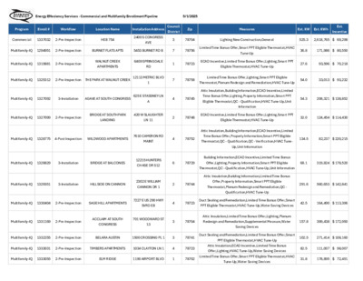
WATER AND WASTEWATER COMMISSION REGULAR CALLED MEETING MINUTES Wednesday, May 21, 2025 The Water and Wastewater Commission convened in a regular called meeting on May 21, 2025 at Waller Creek Center, 625 E 10th Street, Austin, Texas. Commission Members in Attendance: Chair Christopher Maxwell-Gaines, Amanda Marzullo, William Moriarty (remote), Shwetha Pandurangi, Jesse Penn, Mike Reyes, Shannon Trilli, and Vice Chair Marcela Tuñón Commission Members Absent: None Chair Christopher Maxwell-Gaines called the Water and Wastewater Commission to order at 4:04 p.m. PUBLIC COMMUNICATION: GENERAL Stuart Hersh spoke about budget funding for affordable home repair. APPROVAL OF MINUTES 1. Approval of minutes from the April 16, 2025 regular meeting of the Water and Wastewater Commission. The minutes were approved on Commissioner Pandurangi’s motion and Commissioner Marzullo’s second on an 8-0 vote with three vacancies. DISCUSSION AND ACTION 2. Recommend approval to authorize an amendment to the 2021 Facilities - Large Facilities Indefinite Delivery/Indefinite Quantity contract for Austin Water with HEI Civil LLC, to increase the amount by $3,750,000, for a revised total contract amount not to exceed $18,750,000. Funding: $3,750,000 is available in the Capital Budget of Austin Water. Recommended on Commissioner Marzullo’s motion and Vice Chair Tuñón’s second on an 8-0 vote with three vacancies. 3. Recommend approval to authorize a contract for construction services for the North Austin CIPP Wastewater Renewal Project for Capital Delivery Services with Insituform Technologies, LLC in the amount of $2,772,892 plus a $277,290 contingency for a total contract amount not to exceed $3,050,182. Funding: $3,050,182 is available in the Capital Budget of Austin Water. Recommended on Commissioner Marzullo’s motion and Vice Chair Tuñón’s second on an 8-0 vote with three vacancies. 4. Recommend approval to authorize a contract for construction services for the East Allandale White Rock Neighborhood Water and Wastewater System Renewal – Rebid Project for Capital Delivery Services with Facilities Rehabilitation, Inc., in the amount of $4,799,250, plus a $479,925 contingency, for a total contract amount not to exceed $5,279,175. Funding: $5,279,175 is available in the Capital Budget of Austin Water. Recommended on Commissioner Pandurangi’s motion and Vice Chair Tuñón’s second on a 7-0 vote with Commissioner Penn recusing and three vacancies. Page 1 of 4 5. Recommend approval to authorize an amendment to the contract for engineering services for the McNeil Drive Water Transmission Main Project with Black & Veatch Corporation, in the amount of $5,000,000., for a revised total contract amount …
REGULAR CALLED MEETING OF THE HISPANIC/LATINO QUALITY OF LIFE RESOURCE ADVISORY COMMISSION May 20, 2025, 6:00 P.M. City Hall, Boards and Commissions Room #1101 301 West 2nd St Austin, Texas 78701 Some members of the Hispanic/Latino Quality of Life Resource Advisory Commission may be participating by videoconference. Public comment will be allowed in-person or remotely via telephone. Speakers may only register to speak on an item once either in-person or remotely and will be allowed up to three minutes to provide their comments. Registration no later than noon the day before the meeting is required for remote participation by telephone. To register to speak remotely, call or email Christi Vitela, 512- 974-2792, christi.vitela@austintexas.gov. CURRENT COMMISSIONERS: Amanda Afifi Dulce Castañeda Lyssette Galvan Kevin Jackson Jr Ivanna Neri Brian Peña Jesús Perales Yesenia Ramos Melissa Ruiz Daniela Silva AGENDA CALL TO ORDER PUBLIC COMMUNICATION: GENERAL The first ten speakers signed up prior to the meeting being called to order will each be allowed a three-minute allotment to address their concerns regarding items not posted on the agenda. APPROVAL OF MINUTES 1. Approve the minutes of the Hispanic/Latino Quality of Life Resource Advisory Commission regular meeting on March 25, 2025. STAFF BRIEFING 2. Staff briefing regarding an introduction and an overview of the Office of Equity and Inclusion by Dr. Lindsey Wilson, Director, Office of Equity and Inclusion and Shafina Khaki, Human Rights Officer, Office of Equity and Inclusion. DISCUSSION ITEMS 3. Update from the Joint Inclusion Committee representative on the work of the committee during the last two meetings. 4. Presentation regarding Know Your Rights, Annie Fierro, Workers Defense Action Fund. DISCUSSION AND ACTION ITEM 5. Conduct officer elections for the Chair and Vice Chair. FUTURE AGENDA ITEMS ADJOURNMENT The City of Austin is committed to compliance with the American with Disabilities Act. Reasonable modifications and equal access to communications will be provided upon request. Meeting locations are planned with wheelchair access. If requiring Sign Language Interpreters or alternative formats, please give notice at least 2 days (48 hours) before the meeting date. Please call Christi Vitela at the City Clerk’s Department, at 512-974-2792, for additional information; TTY users route through Relay Texas at 711. For more information on the Hispanic Latino Quality of Life Resource Advisory Commission please contact Christi Vitela at 512-974-2792 or christi.vitela@austintexas.gov.
Hispanic/Latino Quality of Life Resource Advisory Commission March 25, 2025 HISPANIC/LATINO QUALITY OF LIFE RESOURCE ADVISORY COMMISSION REGULAR CALLED MEETING MINUTES Tuesday, March 25, 2025 The Hispanic/Latino Quality of Life Resource Advisory Commission convened in a regular called meeting on Tuesday, March 25, 2025, at City Hall, 301 W 2nd St in Austin, Texas. Vice Chair Silva called the Hispanic/Latino Quality of Life Resource Advisory Commission Meeting to order at 6:08 p.m. Commissioners in Attendance: Daniela Silva, Vice Chair Melissa Ruiz Brian Peña Commissioners in Attendance Remotely: Ivanna Neri, Chair Amanda Afifi Lyssette Galvan Jesus Perales PUBLIC COMMUNICATION: GENERAL None. APPROVAL OF MINUTES 1. Approve the minutes of the Hispanic/Latino Quality of Life Resource Advisory Commission regular meeting on February 25, 2025. The minutes from the meeting on February 25, 2025, were approved on Commissioner Peña’s motion, Commissioner Perales’ second on a 7-0 vote. Commissioners Castañeda and Jackson were absent. DISCUSSION ITEMS 2. Discussion of the undocumented immigrant policy at the Austin Police Department. Presentation by Stephanie Gonzales, Equity and Inclusion Coordinator, Austin Police Department, and Fausto Rodriguez, Executive Lieutenant, Austin Police Department. 1 Hispanic/Latino Quality of Life Resource Advisory Commission March 25, 2025 The presentation was made by Stephanie Gonzales, Equity and Inclusion Coordinator, Austin Police Department, Fausto Rodriguez, Executive Lieutenant, Austin Police Department, and Sadot Azzua, Public Information Specialist Senior, Communications and Public Information Office. WORKING GROUP RECOMMENDATION 3. Report of recommendations from the Fiscal Year 2025-2026 Budget Working Group. Discussed. DISCUSSION AND ACTION ITEM 4. Approve a Recommendation to Council regarding the Fiscal Year 2025-2026 Budget. The motion to approve the Fiscal Year 2025-2026 Budget Recommendation was made by Commissioner Perales and seconded by Commissioner Peña. The following amendment was made by Vice Chair Silva, seconded by Commissioner Perales. The amendment was to insert the following to the Fiscal Year 2025-2026 Budget Recommendation. “Family Stabilization Program as a Mechanism for Promoting Housing Stability Recommendation As in previous years, affordability continues to be one of the most common issues expressed by residents. The Family Stabilization Program offers more flexible access to housing support, accords more choice and dignity, reduces discrimination, and offers more efficient and cost-effective housing. The current pilot funds are primarily helping people of color, including Hispanic or Latino/a/x families. Additionally, over half of the participants identify as African American or Latina women. Last year, the Hispanic/Latino Quality of Life Resource Advisory Commission recommended ongoing funding …
REGULAR MEETING of the ZONING AND PLATTING COMMISSION TUESDAY, MAY 20, 2025, 6:00 PM AUSTIN CITY HALL, COUNCIL CHAMBERS, ROOM 1001 301 WEST 2ND STREET AUSTIN, TEXAS Some members of the Zoning and Platting Commission may be participating by videoconference. The meeting may be viewed online at: http://www.austintexas.gov/page/watch-atxn-live. Public comment will be allowed in-person or remotely via telephone. Speakers may only register to speak on an item once either in-person or remotely. Registration no later than 2 PM the day of the meeting is required for remote participation by telephone. For more information on public comment, please see the agenda section “Speaker Registration.” Please contact Ella Garcia, Staff Liaison, for questions regarding speaker registration at LandUseLiaison@austintexas.gov or by phone at 512-978-0821. CURRENT BOARD MEMBERS/COMMISSIONERS: Hank Smith – Chair (District 8) Betsy Greenberg – Vice-Chair (District 10) Ryan Puzycki – Secretary (District 7) Alejandra Flores – Parliamentarian (District 5) Luis Osta Lugo (Mayor’s Representative) Scott Boone (District 1) David Fouts (District 2) Lonny Stern (District 3) Félix De Portu (District 4) Christian Tschoepe (District 6) Taylor Major (District 9) EXECUTIVE SESSION (No public discussion) The Zoning and Platting Commission will announce it will go into Executive Session, if necessary, pursuant to Chapter 551 of the Texas Government Code, to receive advice from Legal Counsel on matters specifically listed on this agenda. The commission may not conduct a closed meeting without the approval of the city attorney. Private Consultation with Attorney – Section 551.071 AGENDA CALL TO ORDER PUBLIC COMMUNICATION: GENERAL Staff Liaison: Ella Garcia, 512-978-0821 Attorney: Steven Maddoux, 512-974-6080 The first four speakers signed up prior to the meeting being called to order will each be allowed a three-minute allotment to address their concerns regarding items not posted on the agenda. APPROVAL OF MINUTES 1. Approve the minutes of the Zoning and Platting Commission regular meeting on Tuesday, May 6, 2025. PUBLIC HEARINGS 2. Rezoning: Location: C14-94-0167.01 - 6500 River Place PDA Amendment #1; District 10 6500 River Place Boulevard, Panther Hollow, Lake Travis Watersheds Owner/Applicant: G&I VII River Place, LP Agent: Request: Staff Rec.: Staff: Drenner Group, PC (David J. Anderson) R&D-PDA to R&D-PDA, to change a condition of zoning Staff Request for Postponement to June 3, 2025 Sherri Sirwaitis, 512-974-3057, sherri.sirwaitis@austintexas.gov Planning Department 3. Rezoning: Location: C14-2025-0037 - City Initiated Rezoning of John Treviño Jr. Metropolitan Park to Public 9501 FM 969 Road, Colorado River, Walnut Creek, Elm Creek …
ZONING AND PLATTING COMMISION REGULAR CALLED MEETING TUESDAY, MAY 6, 2025 The Zoning and Platting convened in a regular meeting on Tuesday, May 6, 2025, at Austin City Hall, Council Chambers, Room 1001, 301 W. Second Street, in Austin, Texas. Chair Smith called the Zoning and Platting Meeting to order at 6:01 p.m. Board Members/Commissioners in Attendance: Hank Smith Betsy Greenberg Felix De Portu David Fouts Luis Osta Lugo Ryan Puzycki Lonny Stern Christian Tschoepe Board Members/Commissioners in Attendance Remotely: Alejandra Flores Board Members/Commissioners Absent: Scott Boone Taylor Major PUBLIC COMMUNICATION: GENERAL Jonathan Coon: Made comments in support of amending the 2018 Camelback PUD to allow a cart path down the hill. APPROVAL OF MINUTES 1. Approve the minutes of the Zoning and Platting Commission regular meeting on Tuesday, April 15, 2025. 1 The minutes from the meeting of April 15, 2025, were approved on the consent agenda on Commissioner Puzycki’s motion, Commissioner Greenberg’s second, on a 9-0 vote. Commissioners Boone and Major were absent. PUBLIC HEARINGS C14-2025-0011 - 11525 Menchaca Road; District 5 11525 Menchaca Road, Slaughter Creek Watershed 2. Rezoning: Location: Owner/Applicant: Shreeji Dham, LLC (Ashish Bhalani) I-SF-2 to GR-CO Request: Recommended Staff Rec.: Cynthia Hadri, 512-974-7620, cynthia.hadri@austintexas.gov Staff: Planning Department The motion to approve Staff’s recommendation of GR-CO for C14-2025-0011 – 11525 Menchaca Road, located at 11525 Menchaca Road, was approved on the consent agenda on Commissioner Puzycki’s motion, Commissioner Greenberg’s second, on a 9-0 vote. Commissioners Boone and Major were absent. 3. PUD Amendment: C814-04-0187.03.SH - Goodnight Ranch PUD Amendment #3; Location: District 2 East side of Old Lockhart Road between Nuckols Crossing Road and Capitol View Drive except Lot 3, Block J, of Goodnight Ranch Phase 2, Onion Creek Watershed Owner/Applicant: Austin Goodnight Ranch, L.P. Agent: Request: City of Austin Planning Department City-initiated PUD Amendment #3 to amend conditions of zoning, and waivers or modifications to City Code requirements, related to the development of Goodnight Ranch PUD. Staff postponement request to June 3, 2025 Nancy Estrada, 512-974-7617, nancy.estrada@austintexas.gov Planning Department Staff Rec.: Staff: The motion to approve Staff’s postponement request to June 3, 2025, was approved on the consent agenda on Commissioner Puzycki’s motion, Commissioner Greenberg’s second, on a 9-0 vote. Commissioners Boone and Major were absent. 2 4. Site Plan SP-2024-0019D - Taylor Slough Dredge Maintenance (Environmental Variance): Location: Owner/Applicant: List of owners shown in back up Agent: Request: 3704-1/2 Meadow Bank Drive, Lake …
MEMORANDUM ************************************************************************ TO: Zoning and Platting Commission Members FROM: Sherri Sirwaitis Planning Department DATE: May 12, 2025 RE: C14-94-0167.01 (6500 River Place PDA Amendment #1) Postponement Request ************************************************************************ staff would The case to June 3, 2025. from expiring so that the staff can continue our review of this rezoning request. the above mentioned like We are asking for this postponement to prevent the case request a postponement of to The postponement request was made in a timely manner and meets the Zoning and Platting Commission’s policy. 02 C14-94-0167.01 - 6500 River Place PDA Amendment #1; District 101 of 2 GR-MU C14-2020-0078 92-0124 C14-01-0040 01-0040 GR-CO C14-98-0225 GR-MU-CO I-SF-2 BOAT\REPAIR/\SALE C814-95-0002.04 C814-95-0002.11 PUD C814-95-0002.10 UNDEV C14-03-0073 GR-CO CS-CO 98-0214 C14-98-0214 AUTO\REPAIR 98-0214 ! ! ! ! ! ! ! GR-CO C14-03-0043 ( 03-0043 99-2075 GO-CO BOAT STORAGE SERVICE\STATION I-SF-2 F M 2 2 2 2 R D LO C14-2015-0122 2008-0027 R84-237 GR C14-2012-0142 ! AUTO\REPAIR ! ! ! ! ! ! ! GR-CO C14-2012-0094 ! ! ! ! ! ! ! 85-13 SF-2 88-42 C7A-00-006 ! ! ! ! ! R&D R I V E R P L A C E B L V D R&D SP-04-0124D ! ! ! ! ! ! ! ! ! ! ! ! ! ! ! ! ! ! ! ! ! ! 92-124 ! ! ! ! ! ! ! ! ! ! ! ! 94-0167 SP-98-0280C R&D-PDA ! ! ! ! ! ! ! ! ! ! ! ! ! ! ! ! ! ! ! ! ! ! ! ! ! ! ! ! ! GO-CO 94-0167 92-0124 SF-5 LO 84-237 2008-0027 GR GR-CO ! C14-2013-0109 ! ! ! ! ! ! ! ! ! ! ! ! C14R-85-394(DE) C14-2008-0027 85-394 GR ! ! ! ! ! C14-97-0083 LR-CO 97-0083 ! ! ! ! ! ! GR-CO ! 95-0193 GR C14-95-0193 SPC-04-0007C 05-0075 C14-05-0075 9 4 -0 1 6 7 ! ! ! ! ! ! ! ! 94-0167 ! ! 92-0124 ! ! ! ! 92-0124 SPC-05-0015C ! ! ! ! ! ! ! ! ! B O N ! GR-CO C14-04-0063 SF-5 92-126 ! ! ! A V E N T U R E D R SP-01-0482C C14-99-2130 00-2144 99-2130 99-0128 SP-99-0126C C14-05-0212 P C14R-87-073 94-0167 C14-00-2144 00-2144 NO-CO SP-01-0482C SP-05-1300C C14-99-0128 99-0128 C14-01-0121 99-2130 DR SUBJECT TRACT ! ! ! ! ! ! PENDING CASE ZONING BOUNDARY ± ZONING …
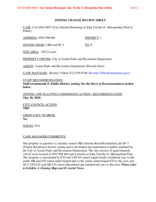
ZONING CHANGE REVIEW SHEET CASE: C14-2025-0037 (City Initiated Rezoning of John Treviño Jr. Metropolitan Park to Public) ADDRESS: 9501 FM 969 DISTRICT: 1 ZONING FROM: I-RR and SF-3 TO: P SITE AREA: 330.22 acres PROPERTY OWNER: City of Austin Parks and Recreation Department AGENT: Austin Parks and Recreation Department (Ricardo Soliz) CASE MANAGER: Beverly Villela (512-978-0740, Beverly.Villela@austintexas.gov) STAFF RECOMMENDATION: Staff recommends P, Public district, zoning. See the Basis of Recommendation section below. ZONING AND PLATTING COMMISSION ACTION / RECOMMENDATION: May 20, 2025: CITY COUNCIL ACTION: TBD ORDINANCE NUMBER: No. ISSUES: N/A CASE MANAGER COMMENTS: The property in question is currently zoned I-RR (Interim-Rural Residential) and SF-3 (Family Residence) district zoning and is developed and maintained as public parkland by the City of Austin Parks and Recreation Department. The site consists of approximately 330.22 acres located at 9501 FM 969 and is known as John Treviño Jr. Metropolitan Park. The property is surrounded by ETJ and I-SF-4A zoned single-family residential uses to the north; DR and ETJ zoned undeveloped land to the south; undeveloped ETJ to the east; and SF-3, GO-CO, and GR-CO zoned educational and institutional uses to the west. Please refer to Exhibits A (Zoning Map) and B (Aerial View). 03 C14-2025-0037 - City Initiated Rezoning of John Treviño Jr. Metropolitan Park to Public1 of 11 C14-2024- Page 2 The applicant is requesting to zone the property to P, Public district, through a City-initiated rezoning effort in response to Resolution No. 20250130-077, which directed staff to rezone this site. Staff is recommending P district zoning, as it reflects the property's current and long-term use as a public park. The applicant is in agreement with the staff recommendation. BASIS OF RECOMMENDATION: 1. The proposed zoning should be consistent with the purpose statement of the district sought. The proposed public (P) district is intended for land owned or leased by federal, state, county, or city government. 2. The proposed zoning should be consistent with the goals and objectives of the City Council. This action directly implements City Council Resolution No. 20250130-077, adopted on January 30, 2025, which initiated this rezoning effort. EXISTING ZONING AND LAND USES: ZONING Site I-RR and SF-3 North ETJ; I-SF-4A South DR and ETJ ETJ East SF-3; GO-CO; GR-CO West LAND USES Parkland Single Family Residential Undeveloped Educational Buildings NEIGHBORHOOD PLANNING AREA: N/A WATERSHED: Colorado River, Walnut Creek, and Elm Creek (Suburban) CAPITOL VIEW CORRIDOR: N/A SCENIC …