7304 KNOX LANE Carter Design Associates (CDA) was retained to review existing research and the residential structure located at 7404 Knox Lane, Austin, Texas. The review was to determine whether the structure met the criteria for historic zoning by the City of Austin. On September 19th, 2024 CDA met on site with the Owner to assess the historic merits of the primary residence and if the criteria were met was there an intact historic structure that could be relocated onsite. The residential structure consists of multiple additions and modifications made by the Knox family throughout their lifetime and ownership of the property. All findings and hypotheses are based on visual observation and research limited to mapping, photographs (contemporary and historic) and written accounts. The original intent of CDA’s review concerned the historic criteria and how, if at all, the structure met the stated criteria. The history of the property suggested that the building had been modified, and there might be an “original” historic building that would better meet the criteria. Our work was to uncover this historic structure and determine how it could be relocated on the site. Findings The site visit forced a revision of the working hypotheses 1. The residence had been radically modified over time and what appeared to the historic features were actually constructed with replica materials. 2. The site/land is just as important as the residential structure 3. The outbuildings better tell the story of the Knox family, based on historic accounts. Today, the residence is a L-shaped plan with a two-story portion to the East; a curved, wrap around covered porch to the Southeast; enclosed shed-roofed porch to the West; and an early one-room addition to the South. Most of the exterior finishes such as the roof, board and batten siding, doors, windows, screens, siding, shutters and trim are modern construction and/or replacements. The finishes do not reflect an historic photo (See Photo X -) which appears to be the South façade of the residence, nor is there any of the (olive-green) stucco mentioned on page 71 of the Austin Originals – Chats with Colorful Characters by Robyn Turner. Many of the interior finishes have been replaced with modern materials chosen for aesthetic reasons by the Owners and intended to reflect an older rustic style. (Exhibit C) 02 C14H-2024-0162 Running Rope Ranch; District 101 of 18 Using historical aerial photos, we can begin to …
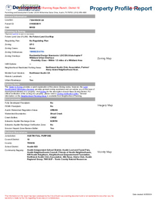
Permitting and Development Center | 6310 Wilhelmina Delco Drive, Austin, TX 78752 | (512) 978-4000 Property Profile Report Residential Design Standards: LDC/25-2-Subchapter F Wildland Urban Interface: Proximity Class - Within 1.5 miles of a Wildland Area Zoning Map Northwest Austin Civic Association, Parmer/ Avery Island Neighborhood Assn. Zoning Guide The Guide to Zoning provides a quick explanation of the above Zoning codes, however, the Land Development Information Services provides general zoning assistance and can advise you on the type of development allowed on a property. Visit Zoning for the description of each Base Zoning District. For official verification of the zoning of a property, please order a Zoning Verification Letter. General information on the Neighborhood Planning Areas is available from Neighborhood Planning. Imagery Map General Information Location: Parcel ID: Grid: 7304 KNOX LN 0140030611 MH30 Planning & Zoning *Right click hyperlinks to open in a new window. Future Land Use (FLUM): No Future Land Use Map Regulating Plan: No Regulating Plan Zoning: Zoning Cases: SF-3 None: Zoning Ordinances: 19990225-070b Zoning Overlays: Infill Options: -- Neighborhood Restricted Parking Areas: Mobile Food Vendors: Northwest Austin CA Historic Landmark: Urban Roadways: -- Yes No No CWQZ NORTH No Yes Environmental Fully Developed Floodplain: FEMA Floodplain: Austin Watershed Regulation Areas: URBAN Watershed Boundaries: Shoal Creek Creek Buffers: Edwards Aquifer Recharge Zone: Edwards Aquifer Recharge Verification Zone: Erosion Hazard Zone Review Buffer: Political Boundaries Jurisdiction: AUSTIN FULL PURPOSE Council District: 10 County: TRAVIS School District: Austin ISD Community Registry: Austin Independent School District, Austin Lost and Found Pets, Austin Neighborhoods Council, Friends of Austin Neighborhoods, NW Austin Neighbors, Neighborhood Empowerment Foundation, Northwest Austin Civic Association, SELTexas, Sierra Club, Austin Regional Group, TNR BCP - Travis County Natural Resources Vicinity Map The Information on this report has been produced by the City of Austin as a working document and is not warranted for any other use. No warranty is made by the City regarding its accuracy or completeness. Date created: 9/25/2024 02 C14H-2024-0162 Running Rope Ranch; District 1018 of 18
7304 KNOX LANE Carter Design Associates (CDA) was retained to review existing research and the residential structure located at 7404 Knox Lane, Austin, Texas. The review was to determine whether the structure met the criteria for historic zoning by the City of Austin. On September 19th, 2024 CDA met on site with the Owner to assess the historic merits of the primary residence and if the criteria were met was there an intact historic structure that could be relocated onsite. The residential structure consists of multiple additions and modifications made by the Knox family throughout their lifetime and ownership of the property. All findings and hypotheses are based on visual observation and research limited to mapping, photographs (contemporary and historic) and written accounts. The original intent of CDA’s review concerned the historic criteria and how, if at all, the structure met the stated criteria. The history of the property suggested that the building had been modified, and there might be an “original” historic building that would better meet the criteria. Our work was to uncover this historic structure and determine how it could be relocated on the site. Findings The site visit forced a revision of the working hypotheses 1. The residence had been radically modified over time and what appeared to the historic features were actually constructed with replica materials. 2. The site/land is just as important as the residential structure 3. The outbuildings better tell the story of the Knox family, based on historic accounts. Today, the residence is a L-shaped plan with a two-story portion to the East; a curved, wrap around covered porch to the Southeast; enclosed shed-roofed porch to the West; and an early one-room addition to the South. Most of the exterior finishes such as the roof, board and batten siding, doors, windows, screens, siding, shutters and trim are modern construction and/or replacements. The finishes do not reflect an historic photo (See Photo X -) which appears to be the South façade of the residence, nor is there any of the (olive-green) stucco mentioned on page 71 of the Austin Originals – Chats with Colorful Characters by Robyn Turner. Many of the interior finishes have been replaced with modern materials chosen for aesthetic reasons by the Owners and intended to reflect an older rustic style. (Exhibit C) 02 C14H-2024-0162 Running Rope Ranch; District 101 of 20 Using historical aerial photos, we can begin to …
Permitting and Development Center | 6310 Wilhelmina Delco Drive, Austin, TX 78752 | (512) 978-4000 Property Profile Report Residential Design Standards: LDC/25-2-Subchapter F Wildland Urban Interface: Proximity Class - Within 1.5 miles of a Wildland Area Zoning Map Northwest Austin Civic Association, Parmer/ Avery Island Neighborhood Assn. Zoning Guide The Guide to Zoning provides a quick explanation of the above Zoning codes, however, the Land Development Information Services provides general zoning assistance and can advise you on the type of development allowed on a property. Visit Zoning for the description of each Base Zoning District. For official verification of the zoning of a property, please order a Zoning Verification Letter. General information on the Neighborhood Planning Areas is available from Neighborhood Planning. Imagery Map General Information Location: Parcel ID: Grid: 7304 KNOX LN 0140030611 MH30 Planning & Zoning *Right click hyperlinks to open in a new window. Future Land Use (FLUM): No Future Land Use Map Regulating Plan: No Regulating Plan Zoning: Zoning Cases: SF-3 None: Zoning Ordinances: 19990225-070b Zoning Overlays: Infill Options: -- Neighborhood Restricted Parking Areas: Mobile Food Vendors: Northwest Austin CA Historic Landmark: Urban Roadways: -- Yes No No CWQZ NORTH No Yes Environmental Fully Developed Floodplain: FEMA Floodplain: Austin Watershed Regulation Areas: URBAN Watershed Boundaries: Shoal Creek Creek Buffers: Edwards Aquifer Recharge Zone: Edwards Aquifer Recharge Verification Zone: Erosion Hazard Zone Review Buffer: Political Boundaries Jurisdiction: AUSTIN FULL PURPOSE Council District: 10 County: TRAVIS School District: Austin ISD Community Registry: Austin Independent School District, Austin Lost and Found Pets, Austin Neighborhoods Council, Friends of Austin Neighborhoods, NW Austin Neighbors, Neighborhood Empowerment Foundation, Northwest Austin Civic Association, SELTexas, Sierra Club, Austin Regional Group, TNR BCP - Travis County Natural Resources Vicinity Map The Information on this report has been produced by the City of Austin as a working document and is not warranted for any other use. No warranty is made by the City regarding its accuracy or completeness. Date created: 9/25/2024 02 C14H-2024-0162 Running Rope Ranch; District 1018 of 20 02 C14H-2024-0162 Running Rope Ranch; District 1019 of 20 02 C14H-2024-0162 Running Rope Ranch; District 1020 of 20
02 C14H-2024-0162 Running Rope Ranch; District 101 of 4 1/2/25, 2:09 PM Mail - Garcia, Ella - Outlook Thank you for your consideration. James E. Jarrett 7301 Running Rope Austin, TX 78731 CAUTION: This is an EXTERNAL email. Please use caution when clicking links or opening attachments. If you believe this to be a malicious or phishing email, please report it using the "Report Message" button in Outlook. For any additional questions or concerns, contact CSIRT at "cybersecurity@austintexas.gov". https://outlook.office.com/mail/inbox/id/AAMkADZmYmIxMjZhLTBiMGMtNDRlNC1iMGNiLTlmOTZiZDJkZTBjOABGAAAAAADejYBKWfI4SoHnPgrYj5s… 2/2 02 C14H-2024-0162 Running Rope Ranch; District 102 of 4 02 C14H-2024-0162 Running Rope Ranch; District 103 of 4 02 C14H-2024-0162 Running Rope Ranch; District 104 of 4
From: To: Cc: Subject: Date: Leah Bojo Contreras, Kalan Temaria Davis Re: Postponement request for 1/7 ZAP Monday, January 6, 2025 4:17:30 PM External Email - Exercise Caution Hi Kalan, We can agree to 1/21. Thanks and Happy New Year! Leah M. Bojo, AICP, Director of Land Use & Entitlements 2705 Bee Caves Road, Suite 100, Austin, TX 78746 Drenner Group, PC | 512-665-1570 cell | | www.drennergroup.com 02 C14H-2024-0162 Running Rope Ranch; District 101 of 1
02 C14H-2024-0162 Running Rope Ranch; District 101 of 51 From: To: Subject: Date: Meghan Ellington Contreras, Kalan Knox Lane zoning and development plans. Monday, January 6, 2025 5:42:14 PM You don't often get email from Learn why this is important External Email - Exercise Caution To whom it may concern: I’m writing in regards to the Knox Lane zoning and development plan. My name is Meghan Ellington and my family lives on Spurlock, directly affected by the traffic from Running Rope. We have three kids, 10, 7 and 4, who constantly use our driveway, yard and adjacent street as a place to safely play. There are young children all up and down our street. There are no sidewalks on our street and all of these children regularly ride bikes and visit neighbors. Most of them also walk to school at Doss Elementary and walk home from school. We are all firmly opposed to the proposal from the developer to build up to 20 units on the historic and environmentally sensitive Knox property. Our opposition is based largely on three points: (1) The developer intends to use a single, short cul de sac as the sole entry and exit for 20 residences (including ADUs), which could conservatively mean 40 vehicles. Knox Lane is a short cul de sac, perhaps 50 yards long. The developer has not conducted a traffic study to my knowledge. The developer has continually increased the number of planned units for the space, without regard to the effects that these vehicles will have on the neighborhood and the environment. The increased traffic will be dangerous to the children in the neighborhood, bad for the many heritage trees adjoining Knox Lane, and detrimental to the area at large. (2) As was discussed previously at the historical commission meeting, the Knox property includes a spring fed pool (it has been estimated there may be up to 6 springs), which are believed to house an endangered salamander. To our knowledge, the developer has not conducted any hydrological study purporting to examine the impact that paving a massive portion of this property (the developer plans to put a private drive in where now there is open ground) will have on recharge zones for these springs or the endangered species inhabiting them. This type of groundwater is scarce natural resource, one that every citizen has an interest in protecting. No development should occur …
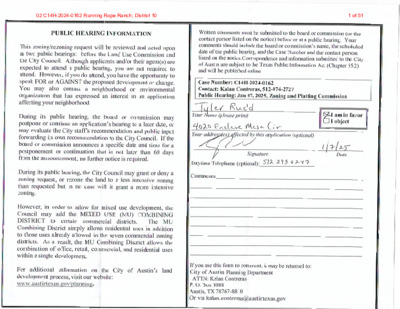
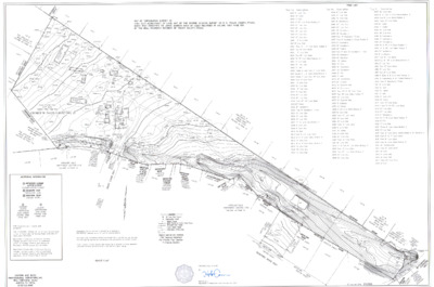
CASE NUMBER: PR-2024-021145; GF-2024-043942 ZONING CHANGE REVIEW SHEET HLC DATES: May 1, 2024; June 5, 2024; July 3, 2024; August 7, 2024; September 4, 2024; October 2, 2024; November 6, 2024 ZAP DATE: January 7, 2025; January 21, 2025 APPLICANT: Historic Landmark Commission (owner-opposed) HISTORIC NAME: Running Rope Ranch WATERSHED: Shoal Creek ADDRESS OF PROPOSED ZONING CHANGE: 7304 Knox Lane ZONING CHANGE: SF-3 to SF-3-H COUNCIL DISTRICT: 10 STAFF RECOMMENDATION: Recommend historic zoning (SF-3-H) only for the portion of the property already restricted by the conservation easement and critical water quality zones. Exclude the portion of the property set aside for the construction of a detention pond. QUALIFICATIONS FOR DESIGNATION: community value, historical associations, archaeology, landscape features HISTORIC LANDMARK COMMISSION ACTION: May 1, 2024 – Postpone the public hearing. September 4, 2024 – initiate historic zoning. November 6, 2024 – Recommend historic zoning under the criteria for community value, archaeology, and landscape features for the conservation easement, critical water quality zones, and THC-identified archaeological sites located on the property. ZONING AND PLATTING COMMISSION ACTION: January 7, 2025 – Postpone the public hearing. CITY COUNCIL ACTION: CASE MANAGER: Kalan Contreras, 512-974-2727 NEIGHBORHOOD ORGANIZATIONS: Austin Independent School District, Austin Lost and Found Pets, Austin Neighborhoods Council, Friends of Austin Neighborhoods, NW Austin Neighbors, Neighborhood Empowerment Foundation, Northwest Austin Civic Association, SELTexas, Sierra Club, Austin Regional Group, TNR BCP - Travis County Natural Resources DEPARTMENT COMMENTS: As the property is listed as a state archaeological site, collaboration with the Texas Historical Commission may be required. BASIS FOR RECOMMENDATION: § 25-2-352(3)(c)(ii) Historical Associations. The property has long-standing significant associations with persons, groups, institutions, businesses, or events of historical importance that contributed significantly to the history of the city, state, or nation or represents a significant portrayal of the cultural practices or the way of life of a definable group of people in a historic time. The property is most recently associated with the Knox family and Running Rope Ranch. The farmstead may have an earlier association with the Spicewood Springs settlement served by Esperanza School. The ranch complex at Knox Lane and Running Rope Lane, known as 7304 or 7306 Knox, was constructed in the early twentieth century—as early as 1900 according to an interview with long-time owner Margaret Knox1—and augmented heavily by the Knox family in the 1940s and later. Located less than a mile from the original site of the Esperanza School,2 …
ZONING CHANGE REVIEW SHEET CASE: C14-2024.0118.SH (8301 Riverstone) DISTRICT: 1 ADDRESS: 8301 Riverstone Drive ZONING FROM: MF-2 TO: SF-3 SITE AREA: approximately 0.31 acres (approximately 13,417 square feet) PROPERTY OWNER: 8301 Riverstone LP AGENT: Austin Revitalization Authority (Bryan Kight) CASE MANAGER: Jonathan Tomko (512) 974-1057, jonathan.tomko@austintexas.gov STAFF RECOMMEDATION: Staff recommends granting family residence (SF-3) district zoning. For a summary of the basis of Staff’s recommendation, please see the basis of recommendation section below. ZONING AND PLATTING COMMISSION ACTION / RECOMMENDATION: December 17, 2024: Applicant postponement request to January 21, 2025 approved on the consent agenda on Commissioner Flores’ motion and Commissioner De Portu’s second, on an 11-0 vote. January 21, 2025: Zoning and Platting Commission is scheduled to hear the case. CITY COUNCIL ACTION: TBD ORDINANCE NUMBER: N/A ISSUES: The subject tract is within a designated Hazardous Pipeline Overlay. There are other structures within this overlay. The applicant has been in discussions with AFD and the AFD reviewer to ensure any proposed development in compliance with applicable codes and regulations. CASE MANAGER COMMENTS: The property in question is currently undeveloped land. The property is located approximately 150 feet north of Loyola Lane and approximately 850 feet west of Decker Lane in the Colony Meadows Subdivision. To the north are two single family homes constructed in approximately 2002. To the east is a residential duplex home constructed in approximately 2002. To the south is undeveloped land, which was rezoned in 2003. To the west is one single family home constructed in approximately 2002. The subject tract is approximately 400 feet east of the Colony Park Imagine Austin Activity Center and approximately 150 feet north of the Loyola Lane Imagine Austin Activity Corridor. BASIS OF RECOMMENDATION: Zoning should allow for reasonable use of the property The applicant’s request allows for reasonable use of the property. The development intensity is appropriate given the location, the surrounding land uses and proposed public investment within the 03 C14-2024-0118.SH - 8301 Riverstone; District 11 of 10 C14-2024-0118.SH 2 immediate vicinity. The subject tract is approximately ¼ mile from the Colony Park Sustainable Community Initiative. Riverstone Drive is an ASMP level 1 roadway within a neighborhood. It is proximate to multiple access points to Loyola Lane, Decker Lane and Colony Loop Drive. The site is within walking distance to the new Metro Rapid Route 837 which provides direct, frequent, limited stop service to Mueller, the University of …
MEMORANDUM **************************************************************************** TO: Zoning and Platting Commission Members FROM: Beverly Villela Planning Department DATE: January 15, 2025 Project - Loyola Facility RE: (C14-2024-0006) Greater Walnut Area Centralized Odor Control Facility **************************************************************************** The case above has been scheduled for the January 21, 2025, Zoning and Platting Commission hearing. The applicant would like to request an indefinite postponement of the above-mentioned case to continue the review of this case. The postponement request was made in a timely manner and meets the Zoning and Platting Commission policy. 04 C14-2024-0006 - Greater Walnut Area Centralized Odor Control Facility Project - Loyola Facility; District 11 of 1
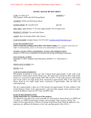
ZONING CHANGE REVIEW SHEET CASE: C14-2024-0173 (City Initiated- 10505 and 10545 Dessau Road) DISTRICT: 1 ADDRESS: 10505 and 10545 Dessau Road ZONING FROM: SF-2 and SF-6-CO TO: GO SITE AREA: approximately 17.542 acres (approximately 764,129 square feet) PROPERTY OWNER: Tim and Cindy Pinson AGENT: Braun & Gresham PLLC (Eric Gomez) CASE MANAGER: Jonathan Tomko (512) 974-1057; jonathan.tomko@austintexas.gov STAFF RECOMMEDATION: Staff recommends granting general office (GO) district zoning. For a summary of the basis of Staff’s recommendation, please see the basis of recommendation section below. ZONING AND PLATTING COMMISSION ACTION / RECOMMENDATION: January 21, 2025: Case is scheduled to be heard by the Zoning and Platting Commission. CITY COUNCIL ACTION: September 12, 2024: Adopted Council Resolution 20240912-117 (See Exhibit C) TBD ORDINANCE NUMBER: N/A ISSUES: None CASE MANAGER COMMENTS: The property in question is on the east side of Dessau Road approximately ½ mile south of the intersection of Dessau Road and East Braker Lane. The subject tract currently has three single family homes on it, constructed in approximately 2000, 2006, and 2014. To the south and east is undeveloped land. To the north is one single family home constructed in approximately 1998. To the west across Dessau Road are two single family homes constructed in approximately 1968 and 2020, and undeveloped land. The site is approximately 4 miles east of The Domain and approximately 10 miles northeast of the Central Business District. It lies approximately 1 mile from three Imagine Austin Activity Centers: Lamar & Rundberg, Cameron & 183 Center, and BFI Center. BASIS OF RECOMMENDATION: Zoning should allow for reasonable use of the property. The requested zoning allows for a more reasonable use of the property. Dessau Road is an ASMP level 4 roadway, an ASMP Transit Priority Corridor, and an Imagine Austin Activity Corridor. The subject tract has approximately 1,000 feet of frontage along Dessau Road. While the applicant is not proposing any additional development at this time, granting general office (GO) is 05 C14-2024-0173 - City Initiated: 10505 and 10545 Dessau Road; District 11 of 13 C14-2024-0173 2 reasonable given the sites location along a major roadway, and proximity more intense zoning along the eastern side of Dessau Road between East Rundb erg Lane and East Braker Lane. Granting this zoning will open up the property for additional uses and site development standards in the future. The proposed zoning should be consistent with the goals and objectives …
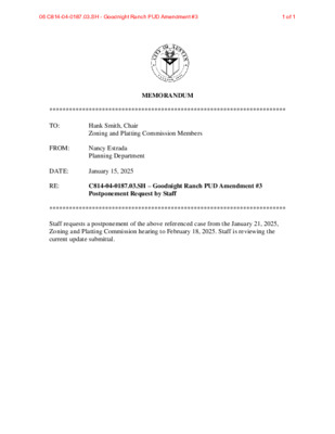
************************************************************************ MEMORANDUM TO: Hank Smith, Chair Zoning and Platting Commission Members FROM: Nancy Estrada Planning Department DATE: January 15, 2025 RE: C814-04-0187.03.SH – Goodnight Ranch PUD Amendment #3 Postponement Request by Staff ************************************************************************ Staff requests a postponement of the above referenced case from the January 21, 2025, Zoning and Platting Commission hearing to February 18, 2025. Staff is reviewing the current update submittal. 06 C814-04-0187.03.SH - Goodnight Ranch PUD Amendment #31 of 1
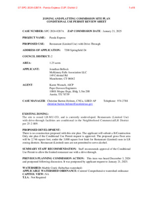
ZONING AND PLATTING COMMISSION SITE PLAN CONDITIONAL USE PERMIT REVIEW SHEET CASE NUMBER: SPC-2024-0287A ZAP COMMISSION DATE: January 21, 2025 PROJECT NAME: Panda Express PROPOSED USE: Restaurant (Limited Use) with Drive-Through ADDRESS OF APPLICATION: 7200 Springfield Dr COUNCIL DISTRICT: 2 AREA: 1.25 acres APPLICANT: AGENT: Jonathan Bellock McKinney Falls Association LLC 149 Colonial Rd Manchester, CT 06042 Karen Wunsch, AICP Pape-Dawson Engineers 10801 Mopac Expy, Bldg 3, Ste 200 Austin, TX 78759 CASE MANAGER: Christine Barton-Holmes, CNUa, LEED AP Telephone: 974-2788 christine.barton-holmes@austintexas.gov EXISTING ZONING: The site is zoned LR-MU-CO, and is currently undeveloped. Restaurants (Limited Use) with drive-through facilities are conditional in the Neighborhood Commercial/LR District per 25-2-809. PROPOSED DEVELOPMENT: There is no construction proposed with this site plan. The applicant will submit a B/Construction Only site plan if the Conditional Use Permit request is approved. The proposed gross floor area will be 2,746 square feet, under the 3,000 square foot limit for Restaurant (Limited) uses in LR zoning districts. Restaurant (Limited) uses are not permitted to serve alcohol. SUMMARY STAFF RECOMMENDATION: Staff recommends approval of the Conditional Use Permit to allow the limited restaurant use with a drive-through. PREVIOUS PLANNING COMMISSION ACTION: This item was heard December 3, 2024 and postponed following discussion. It was postponed by applicant request to January 21, 2025. WATERSHED: Marble Creek (Suburban watershed) APPLICABLE WATERSHED ORDINANCE: Current/ Comprehensive watershed ordinance CAPITOL VIEW: NA T.I.A.: Not Required 07 SPC-2024-0287A - Panda Express CUP; District 21 of 8 PROPOSED F.A.R.: .05 PROPOSED BLDG. CVRG: 5% PROPOSED IC:65.91% PROJECT INFORMATION 1.25 acres EXIST. ZONING: LR-MU-CO (undeveloped) ALLOWED F.A.R.: .5 MAX. BLDG. COVERAGE: 50% MAX. IMPERVIOUS CVRG.: 80% SUMMARY COMMENTS ON SITE PLAN: Land Use: The applicant is requesting a Conditional Use Permit to build a Restaurant (Limited) with a drive-through facility, which is a conditional use in the LR zoning district. The B site plan will comply with all requirements of the Land Development Code prior to its release. Environmental: The site is in the Marble Creek Suburban watershed. The B plan will comply with all Environmental regulations upon its release. Transportation: As currently designed, access will be off Springfield Drive. The site sits on the southwest corner of E William Cannon Dr and Springfield Dr, and the B plan will comply with all Transportation requirements upon its release. SURROUNDING CONDITIONS: Zoning/ Land use North: E William Cannon Drive East: Springfield Drive, then GR-MU-CO (undeveloped) South: SF-4 …
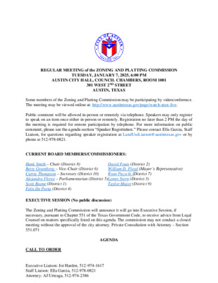
REGULAR MEETING of the ZONING AND PLATTING COMMISSION TUESDAY, JANUARY 7, 2025, 6:00 PM AUSTIN CITY HALL, COUNCIL CHAMBERS, ROOM 1001 301 WEST 2ND STREET AUSTIN, TEXAS Some members of the Zoning and Platting Commission may be participating by videoconference. The meeting may be viewed online at: http://www.austintexas.gov/page/watch-atxn-live. Public comment will be allowed in-person or remotely via telephone. Speakers may only register to speak on an item once either in-person or remotely. Registration no later than 2 PM the day of the meeting is required for remote participation by telephone. For more information on public comment, please see the agenda section “Speaker Registration.” Please contact Ella Garcia, Staff Liaison, for questions regarding speaker registration at LandUseLiaison@austintexas.gov or by phone at 512-978-0821. CURRENT BOARD MEMBERS/COMMISSIONERS: Hank Smith – Chair (District 8) Betsy Greenberg – Vice-Chair (District 6) Carrie Thompson – Secretary (District 10) Alejandra Flores – Parliamentarian (District 5) Lonny Stern (District 3) Scott Boone (District 1) Felix De Portu (District 4) Taylor Major (District 9) David Fouts (District 2) William D. Floyd (Mayor’s Representative) Ryan Puzycki (District 7) EXECUTIVE SESSION (No public discussion) The Zoning and Platting Commission will announce it will go into Executive Session, if necessary, pursuant to Chapter 551 of the Texas Government Code, to receive advice from Legal Counsel on matters specifically listed on this agenda. The commission may not conduct a closed meeting without the approval of the city attorney. Private Consultation with Attorney – Section 551.071 AGENDA CALL TO ORDER Executive Liaison: Joi Harden, 512-974-1617 Staff Liaison: Ella Garcia, 512-978-0821 Attorney: AJ Urteaga, 512-974-2386 PUBLIC COMMUNICATION: GENERAL The first four speakers signed up prior to the meeting being called to order will each be allowed a three-minute allotment to address their concerns regarding items not posted on the agenda. APPROVAL OF MINUTES 1. Approve the minutes of the Zoning and Platting Commission regular meeting on December 17, 2024. PUBLIC HEARINGS C14-2024-0119 - South Center Street; District 3 905 South Center Street, West Bouldin Creek Watershed 2. Rezoning: Location: Owner/Applicant: AJWC Holdings LLC Agent: Request: Staff Rec.: Staff: Jayson Reese Laipenieks MH to SF-3 Recommended Beverly Villela, 512-978-0740, beverly.villela@austintexas.gov Planning Department 3. Rezoning: Location: C14-2024-0069 - AM Station; District 1 7000, 7008, and 7010 Johnny Morris Road, Walnut Creek Watershed Owner/Applicant: Arabon Real Estate LLC Agent: Request: Staff Rec.: Staff: Thrower Design, LLC (Ron Thrower and Victoria Haase) GR-MU-CO to GR-CO-DB90 and CS-MU-CO (as amended) …
ZONING AND PLATTING COMMISSION REGULAR MEETING MINUTES TUESDAY, DECEMBER 17, 2024 The Zoning and Platting Commission convened in a regular meeting on Tuesday December 17, 2024, at Austin City Hall, Council Chambers, Room 1001, 301 W. Second Street, in Austin, Texas. Chair Smith called the Zoning and Platting Commission meeting to order at 6:00 p.m. Board Members/Commissioners in Attendance: Hank Smith Betsy Greenberg Felix De Portu William Floyd Alejandra Flores Taylor Major Ryan Puzycki Lonny Stern Carrie Thompson Board Members/Commissioners in Attendance Remotely: Scott Boone David Fouts APPROVAL OF MINUTES Approve the minutes of the Zoning and Platting Commission regular meeting on December 3, 2024. The minutes from the meeting of December 3, 2024, were approved on Commissioner Flores’ motion, Commissioner De Portu’s second, on an 11-0 vote. 1. 1 PUBLIC HEARINGS C14-2024-0118.SH - 8301 Riverstone; District 1 8301 Riverstone Drive, Elm Creek Watershed 2. Rezoning: Location: Owner/Applicant: 8301 Riverstone LP Agent: Request: Staff Rec.: Staff: Austin Revitalization Authority (Bryan Kight) MF-2 to SF-3 Applicant postponement request to January 21, 2025 Jonathan Tomko, 512-974-1057, jonathan.tomko@austintexas.gov Planning Department The motion to approve the Applicant’s postponement request to January 21, 2025, was approved on the consent agenda on Commissioner Flores’ motion, Commissioner De Portu’s second, on an 11-0 vote. 3. Rezoning: Location: C14-2024-0092 - Allred, Riddle, and W. Slaughter; District 5 2205, 2207, & 2200 Riddle Road; 2200, 2202, 2104, 2106, 2108, & 2206 Allred Drive; 2105, 2107, & 2109 West Slaughter Lane, Slaughter Creek Watershed Owner/Applicant: 2106 Allred LLC; 2105 Slaughter Lane LLC; Ruff Gibson; Scioneaux Agent: Request: Staff Rec.: Staff: Scott; 2205 Riddle Road LLC; 2200 Allred Drive LLC Keepers Land Planning (Ricca Keepers) SF-2; LR-MU-CO to GO-MU; LR-MU; CS-1 Indefinite postponement request by Staff Nancy Estrada, 512-974-7617, nancy.estrada@austintexas.gov Planning Department The motion to approve the Applicant’s indefinite postponement request was approved on the consent agenda on Commissioner Flores’ motion, Commissioner De Portu’s second, on an 11-0 vote. SPC-2023-0357C - North Trail Office Park; District 10 4. Site Plan - Hill Country Roadway: Location: Owner/Applicant: Bull Creek Market LLC Agent: Request: Staff Rec.: Staff: 6601 N Capital of Texas Highway NB, Bull Creek Watershed Thomson Land Engineering, LLC (Mark Roeder) To approve a Site Plan in a Hill Country Roadway overlay zone for a Professional Office Building and associated development. Recommended Randall Rouda, 512-974-3338, randall.rouda@austintexas.gov Christine Barton-Holmes, 512-974-2788, christine.barton- holmes@austintexas.gov Development Services Department The motion to approve Staff’s recommendation to …
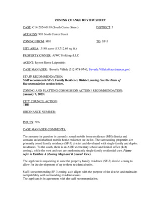
ZONING CHANGE REVIEW SHEET TO: SF-3 DISTRICT: 3 CASE: C14-2024-0119 (South Center Street) ADDRESS: 905 South Center Street ZONING FROM: MH SITE AREA: .3148 acres (13,712.69 sq. ft.) PROPERTY OWNER: AJWC Holdings LLC AGENT: Jayson Reese Laipenieks CASE MANAGER: Beverly Villela (512-978-0740, Beverly.Villela@austintexas.gov) STAFF RECOMMENDATION: Staff recommends SF-3, Family Residence District, zoning. See the Basis of Recommendation section below. ZONING AND PLATTING COMMISSION ACTION / RECOMMENDATION: January 7, 2025: CITY COUNCIL ACTION: TBD ORDINANCE NUMBER: ISSUES: N/A CASE MANAGER COMMENTS: The property in question is currently zoned mobile home residence (MH) district and contains an uninhabited mobile home residence on the lot. The surrounding properties are primarily zoned family residence (SF-3) district and developed with single-family and duplex residences. To the south, there is an AISD elementary school and limited office (LO) zoning), while the west and east are predominantly single-family residential uses. Please refer to Exhibits A (Zoning Map) and B (Aerial View). The applicant is requesting to zone the property family residence (SF-3) district zoning to allow for the development of up to three residential units. Staff is recommending SF-3 zoning, as it aligns with the purpose of the district and maintains compatibility with surrounding residential uses. The applicant is in agreement with the staff recommendation. C14-2024-0119 Page 2 BASIS OF RECOMMENDATION: The proposed zoning should be consistent with the purpose statement of the district sought. The family residence (SF-3) district is the designation for a moderate density single- family residential use and a duplex use on a lot that is a minimum of 5,750 square feet. An SF-3 district designation may be applied to a use in an existing single-family neighborhood with moderate sized lots or to new development of family housing on lots that are 5,750 square feet or more. Up to three units are permitted under single- family residential development standards. Zoning changes should promote compatibility with adjacent and nearby uses. The surrounding properties are predominantly zoned family residence (SF-3) district zoning and developed with single-family and duplex residential uses. Rezoning this site to SF-3 maintains compatibility with the established neighborhood character and zoning pattern. The proposed zoning should promote consistency and orderly planning. Rezoning this lot to family residence (SF-3) district aligns with the established zoning pattern in the surrounding areas, where SF-3 zoning is predominant. This ensures that future development will be compatible with nearby residential uses and maintains the continuity of land …
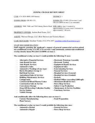
ZONING CHANGE REVIEW SHEET CASE: C14-2024-0069 (AM Station) ZONING FROM: GR-MU-CO ADDRESS: 7000, 7008, and 7010 Johnny Morris Road SITE AREA: tract 1 (eastern) is DISTRICT: 1 ZONING TO: CS-MU-CO on tract 1 and GR-CO-DB90 on tract 2 (as amended) approximately 9.6 acres; tract 2 (western) is approximately 7.68 acres PROPERTY OWNER: Arabon Real Estate, LLC AGENT: Thrower Design, LLC (Ron Thrower and Victoria Haase) CASE MANAGER: Jonathan Tomko (512) 974-1057, jonathan.tomko@austintexas.gov STAFF RECOMMENDATION: Staff supports granting the applicant’s request of general commercial services-mixed use-conditional overlay (CS-MU-CO) on tract 1 and community commercial-conditional overlay-density bonus 90 (GR-CO-DB90) on tract 2. The conditional overlay on tract 1 would prohibit the following 31 uses: - Alternative Financial Services - Auto Rental Services - Auto Repair Services - Automotive Sales - Automotive Washing (of any type) - Bed & Breakfast (Group 1) - Bail Bond Services - Agricultural Sales & Services - Building Maintenance Services - Campground - Commercial Blood Plasma Center - Construction Sales & Service - Convenience Storage - Drop-Off Recycling Collection Facility - Service Station - Vehicle Storage - Electronic Prototype Assembly - Electronic Testing - Equipment Repair Services - Equipment Sales - Exterminating Services - Funeral Services - Hospital Services (General) - Hospital Services (Limited) - Kennels - Medical Offices (exceeding 5,000 sqft) - Monument Retail Services - Pawn Shop Services - Indoor Crop Production - Maintenance & Service Facilities - Veterinary Services And conditionally allow the following three uses on tract 1: - Custom Manufacturing - Plant Nursery - Food Preparation The conditional overlay on tract 2 would prohibit the following nine uses: - Automotive Rental - Automotive Repair - Funeral Services - Pawn Shop Services C14-2024-0069 2 - Automotive Washing (of any type - Automotive Sales - Exterminating Services - Service Station - Drive-in Service as an accessory use The applicant is also seeking a waiver of section 25-2-652(F)(3)(b) the ground-floor commercial requirement on tract 2 under, which staff also supports. For a summary of the basis of Staff’s recommendation, please see the basis of recommendation section below. ZONING AND PLATTING COMMISSION ACTION / RECOMMENDATION: October 1, 2024: The motion to approve the Applicant’s postponement request to November 19, 2024, was approved on the consent agenda on Commissioner Flores’ motion, Commissioner De Portu’s second on an 8-0 vote. Chair Smith and Commissioners Floyd and Major were absent. November 19, 2024: The motion to approve Staff’s postponement request …
7304 KNOX LANE Carter Design Associates (CDA) was retained to review existing research and the residential structure located at 7404 Knox Lane, Austin, Texas. The review was to determine whether the structure met the criteria for historic zoning by the City of Austin. On September 19th, 2024 CDA met on site with the Owner to assess the historic merits of the primary residence and if the criteria were met was there an intact historic structure that could be relocated onsite. The residential structure consists of multiple additions and modifications made by the Knox family throughout their lifetime and ownership of the property. All findings and hypotheses are based on visual observation and research limited to mapping, photographs (contemporary and historic) and written accounts. The original intent of CDA’s review concerned the historic criteria and how, if at all, the structure met the stated criteria. The history of the property suggested that the building had been modified, and there might be an “original” historic building that would better meet the criteria. Our work was to uncover this historic structure and determine how it could be relocated on the site. Findings The site visit forced a revision of the working hypotheses 1. The residence had been radically modified over time and what appeared to the historic features were actually constructed with replica materials. 2. The site/land is just as important as the residential structure 3. The outbuildings better tell the story of the Knox family, based on historic accounts. Today, the residence is a L-shaped plan with a two-story portion to the East; a curved, wrap around covered porch to the Southeast; enclosed shed-roofed porch to the West; and an early one-room addition to the South. Most of the exterior finishes such as the roof, board and batten siding, doors, windows, screens, siding, shutters and trim are modern construction and/or replacements. The finishes do not reflect an historic photo (See Photo X -) which appears to be the South façade of the residence, nor is there any of the (olive-green) stucco mentioned on page 71 of the Austin Originals – Chats with Colorful Characters by Robyn Turner. Many of the interior finishes have been replaced with modern materials chosen for aesthetic reasons by the Owners and intended to reflect an older rustic style. (Exhibit C) Using historical aerial photos, we can begin to put to piece together the evolution of the residence …