C20-2022-003 ORDINANCE AMENDMENT REVIEW SHEET C20-2022-003 South Central Waterfront Combining District and Density Bonus Program. Amendment: Description: Conduct a public hearing and consider an ordinance amending City Code Title 25 to create a new zoning district and modify related site development regulations and compatibility standards; and create a new zoning district for density bonus that includes granting additional floor-to-area ratio in exchange for providing community benefits; to establish boundaries for the new zoning districts located in the vicinity commonly known as the South Central Waterfront; and initiating zoning and rezoning for all properties within the South Central Waterfront District except those with Planned Unit Development zoning, Planned Development Area zoning, and subject to Planned Development Agreement, and initiate necessary neighborhood plan amendments for the properties located in the new zoning district’s boundaries. Background: On June 16, 2016, the South Central Waterfront Vision Framework Plan (Vision Plan) was adopted as an amendment to the Imagine Austin Comprehensive Plan. As defined in the Vision Plan, the South Central Waterfront district encompasses roughly 118 acres. The intent of the Vision Plan was to leverage forecasted development through a districtwide approach that creates a dynamic people-centered district in Central Austin by: - Establishing a lively, attractive pedestrian environment; - Expanding open space and creating great public places; - Enhancing connections to and along the waterfront; and - Providing 20% new affordable housing units, or approximately 527 affordable units in the district. A districtwide approach had been identified as an essential method in realizing the intent of the Vision Plan. Through this approach, the South Central Waterfront is hoped to become a model for how a districtwide green infrastructure system, paired with quality urban design, can provide an interconnected network of public spaces – streets, streetscapes, lakeside trails, and parks – that provides the framework for redevelopment and districtwide value capture to fund other community benefits, such as affordable housing. The urban development envisioned in the Vision Plan requires modifications to the existing zoning and development regulations. To support the development envisioned in the Vision Plan, the City Council passed Resolution Number 20220915-090 on September 15, 2022, to initiate the development of regulations for the South Central Waterfront area. In the resolution, Council asked staff to create regulations that consider today’s market realities, anticipate future demand, and realize the intent of the Vision Plan to: 1 C20-2022-003 - Create a density bonus program “akin” to …
PLANNING COMMISSION AGENDA Tuesday, April 9, 2024 The Planning Commission will convene at 6:00 PM on Tuesday, April 9, 2024, at City Hall, Council Chambers 1001 301 W. Second Street, Austin, TX. Some members of the Planning Commission may be participating by videoconference. The meeting may be viewed online at: http://www.austintexas.gov/page/watch-atxn-live Greg Anderson – Secretary (District 4) Awais Azhar – Vice-Chair (Mayor) Nadia Barrera-Ramirez (District 3) Grayson Cox (District 10) Adam Haynes (Mayor) Claire Hempel – Chair (District 8) Patrick Howard (District 1) Ryan Johnson (District 7) Felicity Maxwell (District 5) Jennifer Mushtaler (District 6) Alberta Phillips (Mayor) Danielle Skidmore (District 9) Alice Woods – Parliamentarian (District 2) Ex-Officio Members Jessica Cohen – Chair of Board of Adjustment Jesús Garza – Interim City Manager Candace Hunter – AISD Board of Trustees Richard Mendoza – Director of Transportation and Public Works EXECUTIVE SESSION (No public discussion) The Planning Commission will announce it will go into Executive Session, if necessary, pursuant to Chapter 551 of the Texas Government Code, to receive advice from Legal Counsel on matters specifically listed on this agenda. The Commission may not conduct a closed meeting without the approval of the city Attorney: Chrissy Mann, 512-974-2179 Executive Liaison: Joi Harden 512-974-1617 Commission Liaison: Andrew Rivera, 512-974-6508 attorney. Private Consultation with Attorney – Section 551.071 PUBLIC COMMUNICATION The first four (4) speakers signed up prior to the closure of speaker registration will each be allowed a three-minute allotment to address their concerns regarding items not posted on the agenda. APPROVAL OF MINUTES 1. Approve the minutes of March 26, 2024 PUBLIC HEARING 2. Plan Amendment: Location: Owner/Applicant: Agent: Request: Staff Rec.: Staff: Postponement Request: 3. Plan Amendment: Location: Owner/Applicant: Agent: Request: Staff Rec.: Staff: Postponement Request: NPA-2023-0014.03 - 4302 Nuckols Crossing; District 2 4302 Nuckols Crossing, Williamson Creek Watershed Katherine Barnidge LOC Consultants – Civil Division (Sergio Lozano Sanchez) Single Family to Multifamily Residential land use Pending Maureen Meredith, 512-974-2695, maureen.meredith@austintexas.gov Planning Department Staff postponement request to May 28, 2024. NPA-2023-0018.06 - 6725 Shirley Avenue 6719, 6725 Shirley Ave and 605 William Street, Waller Creek Watershed 6725 Shirley Avenue, LLC Drenner Group, PC (Leah M. Bojo) To change the base maximum building height from 60 feet to 120 feet with participation in the density bonus program. The land use on the future land use map is Specific Regulating District. There is no proposed change to the future land use …
TECHNICAL MEMORANDUM TO: FROM: Mr. Bradford Massingill III Resident at 110 Red Bird Lane Williamson Creek Watershed J. Eduardo Perez, E.I.T., C.F.M. Watershed Protection Department September 25, 2023 DATE: SUBJECT: Drainage Pattern and Public Infrastructure around Your Property The purpose of this memorandum is to document the drainage pattern and the public infrastructure affecting the drainage pattern near your property. Your address 110 RED BIRD LN is near S Congress Ave and E Stassney Ln, and in the Williamson Creek watershed. The drainage pattern of any creek ecology is affected by qualities in the landscape such as ground surface slope and type of ground cover. When rain falls water collects in territorial low spots and eventually, once enough water has ponded in these spots, water pours ‘downstream,’ in strict accordance to laws of physics. Streams wash over natural terrain via creeks, channels, and streambeds eroding landscapes into gravel and clay. The earthen material, once eaten away by washing water, is deposited elsewhere as silt and mud, molding landscapes and natural terrains. The size of this effect can be witnessed in person or can be captured via satellite imagery. The drainage assets that affect the drainage pattern near your home are summarized in the The awesome behavior of running water is consistent, dynamic, ecological, and economic. For these reasons, the City of Austin Watershed Protection Department keeps track of drainage assets that allow for these phenomena to occur in a harmonious and comprehensible manner for the residents of Austin. Map titled: WPD Map of Drainage Assets near 110 Red Bird Lane. 110 Red Bird Ln. Three Types of Infrastructure to Convey Rainfall Runoff BACKGROUND Drainage data and other calculations are provided in the Table: Drainage Summary for Concept Designs for engineered drainage infrastructure are provided in Appendix A: J. Eduardo Perez EIT, CFM and Kathy Rock visited the address 110 RED BIRD LN as a continuation of a flood investigation in this block of Red Bird Lane. The group witnessed what Mr. Massingill had experienced with the lack of storm-drain infrastructure between the north and south lots of Red Bird Lane. Preliminary drainage calculations showed a large drainage area, and a quick inventory of WPD drainage assets yielded no results. E. Perez called Mr. Massingill after visiting the site address to confirm field investigation discoveries. After speaking with Mr. Massingill, I (J. E. Perez) took to initiative to author this technical …
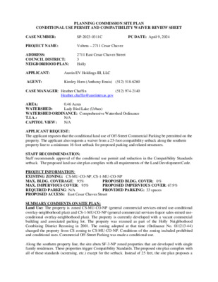
PLANNING COMMISSION SITE PLAN CONDITIONAL USE PERMIT AND COMPATIBILITY WAIVER REVIEW SHEET (512) 974-2140 SP-2023-0311C PC DATE: April 9, 2024 Voltera – 2711 Cesar Chavez Austin EV Holdings III, LLC Heather.chaffin@austintexas.gov 2711 East Cesar Chavez Street 3 Holly Kimley Horn (Anthony Ennis) (512) 518-6260 CASE NUMBER: PROJECT NAME: ADDRESS: COUNCIL DISTRICT: NEIGBORHOOD PLAN: APPLICANT: AGENT: CASE MANAGER: Heather Chaffin 0.46 Acres AREA: WATERSHED: Lady Bird Lake (Urban) WATERSHED ORDINANCE: Comprehensive Watershed Ordinance N/A T.I.A.: CAPITOL VIEW: N/A APPLICANT REQUEST: The applicant requests that the conditional land use of Off-Street Commercial Parking be permitted on the property. The applicant also requests a waiver from a 25-foot compatibility setback along the southern property line to a minimum 16-foot setback for proposed parking and related structures. STAFF RECOMMENDATION: Staff recommends approval of the conditional use permit and reduction in the Compatibility Standards setback. The proposed land use site plan complies with all requirements of the Land Development Code. PROJECT INFORMATION: EXISTING ZONING: CS-MU-CO-NP, CS-1-MU-CO-NP MAX. BLDG. COVERAGE: 95% MAX. IMPERVIOUS COVER: 95% REQUIRED PARKING: N/A PROPOSED ACCESS: East Cesar Chavez Street SUMMARY COMMENTS ON SITE PLAN: Land Use: The property is zoned CS-MU-CO-NP (general commercial services-mixed use-conditional overlay-neighborhood plan) and CS-1-MU-CO-NP (general commercial services-liquor sales-mixed use- conditional overlay-neighborhood plan). The property is currently developed with a vacant commercial building and associated parking lot. The property was rezoned as part of the Holly Neighborhood Combining District Rezoning in 2001. The zoning adopted at that time (Ordinance No. 011213-44) changed the property from CS zoning to CS-MU-CO-NP. Conditions of the zoning included prohibited and conditional uses. Commercial Off-Street Parking was made a conditional use. Along the southern property line, the site abuts SF-3-NP zoned properties that are developed with single family residences. These properties trigger Compatibility Standards. The proposed site plan complies with all of these standards (screening, etc.) except for the setback. Instead of 25 feet, the site plan proposes a PROPOSED BLDG. COVER: 0% PROPOSED IMPERVIOUS COVER: 67.9% PROVIDED PARKING: 33 spaces Voltera- 2711 Cesar Chavez setback of 16 feet that would allow a paved area that contains electric vehicle parking stations. The parking spaces would be located 23 feet from the property line. The proposed site plan includes 33 parking spaces with electric charging stations. No buildings are proposed. SP-2023-0311C 2 Environmental: The site is located in the Lady Bird Lake Watershed and subject to Urban Watershed regulations. Transportation: The property located …
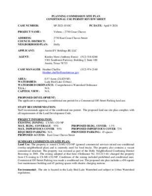
PLANNING COMMISSION SITE PLAN CONDITIONAL USE PERMIT REVIEW SHEET (512) 974-2140 SP-2023-0310C PC DATE: April 9 2024 Voltera – 2730 Cesar Chavez Austin EV Holdings III, LLC Heather.chaffin@austintexas.gov 2730 East Cesar Chavez Street 3 Holly Kimley Horn (Anthony Ennis) (512) 518-6260 5301 Southwest Parkway, Building 2, Suite 100 Austin, Texas 78735 CASE NUMBER: PROJECT NAME: ADDRESS: COUNCIL DISTRICT: NEIGBORHOOD PLAN: APPLICANT: AGENT: CASE MANAGER: Heather Chaffin AREA: 0.57 Acres (24,829 SF) Lady Bird Lake (Urban) WATERSHED: WATERSHED ORDINANCE: Comprehensive Watershed Ordinance T.I.A.: N/A CAPITOL VIEW: N/A PROPOSED DEVELOPMENT: The applicant is requesting a conditional use permit for a Commercial Off-Street Parking land use. STAFF RECOMMENDATION: Staff recommends approval of the conditional use permit. The proposed land use site plan complies with all requirements of the Land Development Code. PROJECT INFORMATION: EXISTING ZONING: CS-MU-CO-NP MAX. BLDG. COVERAGE: 95% MAX. IMPERVIOUS COVER: 95% REQUIRED PARKING: N/A PROPOSED ACCESS: East Cesar Chavez Street SUMMARY COMMENTS ON SITE PLAN: Land Use: The property is zoned CS-MU-CO-NP (general commercial services-mixed use-conditional overlay-neighborhood plan) and is currently used for food trucks. The property also contains a vacant commercial structure. The property was rezoned as part of the Holly Neighborhood Combining District Rezoning in 2001. The zoning adopted at that time (Ordinance No. 011213-44) changed the property from CS zoning to CS-MU-CO-NP. Conditions of the zoning included prohibited and conditional uses. Commercial Off-Street Parking was made a conditional use. The proposed site plan includes a 456 square foot maintenance building and 45 parking spaces with electric charging stations. PROPOSED BLDG. COVER: 1.5% PROPOSED IMPERVIOUS COVER: 72% PROVIDED PARKING: 45 spaces Environmental: The site is located in the Lady Bird Lake Watershed and subject to Urban Watershed regulations. 2 SP-2023-0310C Voltera- 2730 Cesar Chavez Transportation: The property is bounded by an alley to the north, Pleasant Valley Road to the east, and Cesar Chavez Street to the south. Vehicular and pedestrian access will be via East Cesar Chavez Street only. SURROUNDING CONDITIONS: Zoning/ Land Use North: MF-2-NP, CS-1-MU-CO-NP, SF-3-NP: Multifamily residential, Restaurant, Undeveloped, Single family residential East: CS-MU-CO-NP: Vacant/Undeveloped South: CS-MU-CO-NP: Professional office/retail, Vacant commercial buildings West: CS-MU-CO-NP: Restaurant (vacant) NEIGHBORHOOD ORGANIZATIONS Austin Independent School District Austin Neighborhoods Council Buena Vista Neighborhood Association Del Valle Community Coalition East Cesar Chavez IBIZ District Friends of Austin Neighborhoods Homeless Neighborhood Association Neighbors United for Progress SELTexas Holly Neighborhood Association Guadalupe Neighborhood Development Corporation CONDITIONAL USE PERMIT D. 25-5-145. A site …
City Of Austin Planning Dept South Central Waterfront Density Bonus Assessment January 2024 Contents Background Scope of Work I. II. III. Development Scenario Analysis 1 Background The City of Austin Planning Department is working to craft a density bonus program to encourage developers to provide community benefits in exchange for entitlement incentives within the South-Central Waterfront (“SCW”) planning area. The City sought third party review of the current Excel-based tool and underlying assumptions. Specifically, the City sought to understand: ▪ Are the methodology and mechanics of the SCW density bonus scenario tool functional and easy to use? ▪ Is this density bonus program sufficiently calibrated to motivate a developer to choose this program over a PUD process? 2 Stress Test Methodology ▪ Determine the value of incentive density granted through the density bonus program by netting the incremental project value for a participating project from one that completes a project under by-right zoning. ▪ Test two development options for the SCW District – small-scale and large- scale ▪ Compare project performance metrics between by-right and density bonus projects to test feasibility and relative value: ▪ Return on Cost ▪ Levered Internal Rate of Return ▪ Equity Multiple ▪ Capitalized Project Value 2. Stress Test Density Bonus Model Pro Forma Model Output BD Program Capitalized Market Value Total Development Costs BD Program Value Generated By-Right Capitalized Market Value Total Development Costs By-Right Capitalized Market Value BD Program Value Generated By-Right Capitalized Market Value Value of Incentive Density = = = - - - 3 2. Stress Test Density Bonus Model Development Scenarios Site Size GSF Multifamily (GSF) Small Scale Large Scale By-Right (CS-1-V-NP) Density Bonus Program By-Right (CS-1-V-NP) Density Bonus Program 1.5 Acres 4 Acres 191,233 127,100 524,825 348,150 509,872 338,850 1,373,957 910,300 (2 buildings) 30,000 Retail (GSF) 3,630 10,000 9,680 Parking (spaces)** 60,503 (173) 166,675 (476) 161,342 (461) 433,657 (1239) FAR 2.0* 8.0 2.0* 7.9 *Does not include parking area ** Above grade parking spots are 350 SF/Space 4 Bonus Fee in Lieu $5 (Residential) / $9 (Non-residential) / 5% On-site Affordable Housing 2. Stress Test Density Bonus Model Small Scale Development Large Scale Development ▪ By-right projects do not meet any of the 3 performance metric thresholds. ▪ Adding bonus density results in a marginally feasible project; returns drop with each public benefit (on-site affordable units / bonus fee) ▪ The inclusion of on-site affordable housing impacts project returns …
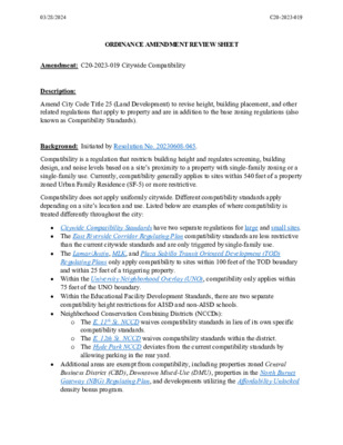
ORDINANCE AMENDMENT REVIEW SHEET Amendment: C20-2023-019 Citywide Compatibility Description: Amend City Code Title 25 (Land Development) to revise height, building placement, and other related regulations that apply to property and are in addition to the base zoning regulations (also known as Compatibility Standards). Background: Initiated by Resolution No. 20230608-045. Compatibility is a regulation that restricts building height and regulates screening, building design, and noise levels based on a site’s proximity to a property with single-family zoning or a single-family use. Currently, compatibility generally applies to sites within 540 feet of a property zoned Urban Family Residence (SF-5) or more restrictive. Compatibility does not apply uniformly citywide. Different compatibility standards apply depending on a site’s location and use. Listed below are examples of where compatibility is treated differently throughout the city: • Citywide Compatibility Standards have two separate regulations for large and small sites. • The East Riverside Corridor Regulating Plan compatibility standards are less restrictive than the current citywide standards and are only triggered by single-family use. • The Lamar/Justin, MLK, and Plaza Saltillo Transit Oriented Development (TOD) Regulating Plans only apply compatibility to sites within 100 feet of the TOD boundary and within 25 feet of a triggering property. • Within the University Neighborhood Overlay (UNO), compatibility only applies within 75 feet of the UNO boundary. • Within the Educational Facility Development Standards, there are two separate compatibility height restrictions for AISD and non-AISD schools. • Neighborhood Conservation Combining Districts (NCCDs): o The E. 11th St. NCCD waives compatibility standards in lieu of its own specific compatibility standards. o The E. 12th St. NCCD waives compatibility standards within the district. o The Hyde Park NCCD deviates from the current compatibility standards by allowing parking in the rear yard. • Additional areas are exempt from compatibility, including properties zoned Central Business District (CBD), Downtown Mixed-Use (DMU), properties in the North Burnet Gateway (NBG) Regulating Plan, and developments utilizing the Affordability Unlocked density bonus program. 03/28/2024C20-2023-019 For more information about the various compatibility standards in the code, see Exhibit A, Current vs Proposed Compatibility. Compatibility Standards were codified with the adoption of the current Land Development Code in 1984. Their purpose, as stated in the 1984 code, is to “preserve and protect single-family residential neighborhoods” and “to maintain the privacy and to allow the outdoor enjoyment typically provided in single family districts and neighborhoods.” Before compatibility was created, there was an …
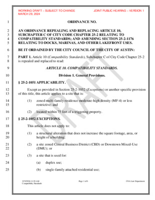
WORKING DRAFT – SUBJECT TO CHANGE JOINT PUBLIC HEARING – VERSION 1 MARCH 29, 2024 ORDINANCE NO. AN ORDINANCE REPEALING AND REPLACING ARTICLE 10, SUBCHAPTER C OF CITY CODE CHAPTER 25-2 RELATING TO COMPATIBILITY STANDARDS; AND AMENDING SECTION 25-2-1176 RELATING TO DOCKS, MARINAS, AND OTHER LAKEFRONT USES. BE IT ORDAINED BY THE CITY COUNCIL OF THE CITY OF AUSTIN: PART 1. Article 10 (Compatibility Standards), Subchapter C of City Code Chapter 25-2 is repealed and replaced to read: ARTICLE 10. COMPATIBILITY STANDARDS. Division 1. General Provisions. § 25-2-1051 APPLICABILITY. Except as provided in Section 25-2-1052 (Exceptions) or another specific provision of this title, this article applies to a site that is: (1) zoned multi-family residence moderate-high density (MF-4) or less restrictive; and (2) located within 75 feet of a triggering property. § 25-2-1052 EXCEPTIONS. This article does not apply to: (1) (2) a structural alteration that does not increase the square footage, area, or height of a building; a site zoned Central Business District (CBD) or Downtown Mixed-Use (DMU); or (3) a site that is used for: (a) duplex use; (b) single-family attached residential use; 1 2 3 4 5 6 7 8 9 10 11 12 13 14 15 16 17 18 19 20 21 22 23 24 25 Page 1 of 6 COA Law Department 3/29/2024 11:20 AM Compatibility Standards 26 27 28 29 30 31 32 33 34 35 36 37 38 39 40 41 42 43 44 45 46 47 48 49 WORKING DRAFT – SUBJECT TO CHANGE JOINT PUBLIC HEARING – VERSION 1 MARCH 29, 2024 (c) single-family residential use; (d) two-unit residential use; (e) three-unit residential; (f) adult-care services use (limited or general); or (g) childcare services use (limited or general). § 25-2-1053 TRIGGERING PROPERTY. A triggering property is a site: (1) with at least one dwelling unit but less than four dwelling units; and (2) zoned Urban Family Residence (SF-5) or more restrictive. § 25-2-1054 SITE-SPECIFIC AMENDMENTS. (A) Except as provided in Subsection (B), council may grant site-specific amendments to height limits established in Section 25-2-1061 (Compatibility Height Limits) if council determines that an amendment is appropriate and will not harm the surrounding area. (B) A site is not eligible for a site-specific amendment if the site is: (1) zoned: (a) special purpose base zoning district; (b) density bonus (DB) combining district; or (2) subject to the university neighborhood overlay (UNO). (C) An …
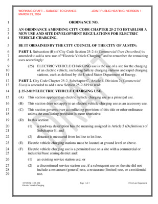
1 2 3 4 5 6 7 8 9 10 11 12 13 14 15 16 17 18 19 20 21 22 23 24 25 26 27 28 29 WORKING DRAFT – SUBJECT TO CHANGE JOINT PUBLIC HEARING -VERSION 1 MARCH 29, 2024 ORDINANCE NO. AN ORDINANCE AMENDING CITY CODE CHAPTER 25-2 TO ESTABLISH A NEW USE AND SITE DEVELOPMENT REGULATIONS FOR ELECTRIC VEHICLE CHARGING. BE IT ORDAINED BY THE CITY COUNCIL OF THE CITY OF AUSTIN: PART 1. Subsection (B) of City Code Section 25-2-4 (Commercial Uses Described) is amended to add a new use of “Electric Vehicle Charging” and to renumber the remaining uses accordingly: (25) ELECTRIC VEHICLE CHARGING use is the use of a site for the charging of an electric vehicle, including battery charging stations and rapid charging stations, each as defined by the United States Department of Energy. PART 2. City Code Chapter 25-2, Subchapter C, Article 4, Division 2 (Commercial Uses) is amended to add a new Section 25-2-819 to read: § 25-2-819 ELECTRIC VEHICLE CHARGING USE. (A) This section applies to an electric vehicle charging use as a principal use. (B) This section does not apply to an electric vehicle charging use as an accessory use. (C) This section governs over a conflicting provision of this title or other ordinance unless the conflicting provision is more restrictive. (D) In this section: (1) a roadway description has the meaning assigned in Article 5 (Definitions) of Subchapter E; and (2) distance is measured from lot line to lot line. (E) Electric vehicle charging stations must be located at ground level or above. (F) Electric vehicle charging use is a permitted use on a site with a commercial or industrial base zoning district and: (1) an existing service station use; or (2) a discontinued service station use, if a subsequent use on the site did not include a restaurant (general) use, a restaurant (limited) use, or a residential use. Page 1 of 3 COA Law Department 3/29/2024 11:28 AM Electric Vehicle Charging WORKING DRAFT – SUBJECT TO CHANGE JOINT PUBLIC HEARING -VERSION 1 MARCH 29, 2024 (G) Subject to the requirements of Subsections (H), (I), and (J), electric vehicle charging use is a permitted or conditional use on a site zoned: (1) General Commercial Services (CS); (2) Commercial Liquor Sales (CS-1); (3) Commercial Highway (CH); (4) Industrial Park (IP); (5) Major Industry (MI); (6) Limited Industrial …
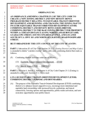
WORKING DRAFT – SUBJECT TO CHANGE JOINT PUBLIC HEARING – VERSION 1 MARCH 29, 2024 ORDINANCE NO. AN ORDINANCE AMENDING CHAPTER 25-2 OF THE CITY CODE TO CREATE A NEW ZONING DISTRICT AND NEW DENSITY BONUS PROGRAM DISTRICT RELATING TO EQUITABLE-TRANSIT ORIENTED DEVELOPMENT AND REZONING AND CHANGING THE ZONING MAP TO INCLUDE EQUITABLE TRANSIT-ORIENTED DEVELOPMENT (ETOD) COMBINING DISTRICT AND DENSITY BONUS ETOD (DBETOD) COMBINING DISTRICT TO THE BASE ZONING DISTRICT FOR PROPERTY WITHIN A CERTAIN DISTANCE ALONG NORTH LAMAR BOULEVARD, GUADALUPE STREET, SOUTH CONGRESS AVENUE, AND LOCATED SOUTH OF U.S. HWY 183 AND NORTH OF LIGHTSEY ROAD/WOODWARD STREET. BE IT ORDAINED BY THE CITY COUNCIL OF THE CITY OF AUSTIN: PART 1. Subsection (F) of City Code Section 25-2-32 (Zoning Districts and Map Codes) is amended to delete “corridor overlay” and to add a new combining district that reads as follows: (F) Combining districts and map codes are as follows: (22) Equitable Transit-Oriented Development ….ETOD (23) density bonus ETOD …. DBETOD PART 2. Division 6, Article 2, Subchapter A of City Code Chapter 25-2 (Zoning) is amended to add a new Section 25-2-182 to read: § 25-2-182 EQUITABLE TRANSIT-ORIENTED DEVELOPMENT (ETOD) COMBINING DISTRICT PURPOSE AND BOUNDARIES. (A) The purpose of the Equitable Transit-Oriented Development (ETOD) combining district is to enhance transit-supportive uses, encourage more intentional and equitable land stewardship with increased bicycle, pedestrian, and transit connectivity, housing options and opportunities, public realm activation, and new economic opportunities near public transit. 1 2 3 4 5 6 7 8 9 10 11 12 13 14 15 16 17 18 19 20 21 22 23 24 25 26 27 28 29 3/29/2024 11:31 AM ETOD/ ETOD Density Bonus Combining District Page 1 of 16 COA Law Department 30 31 32 33 34 35 36 37 38 39 40 41 42 43 44 45 46 47 48 49 50 51 52 53 54 55 56 WORKING DRAFT – SUBJECT TO CHANGE JOINT PUBLIC HEARING – VERSION 1 MARCH 29, 2024 (B) The boundaries of the ETOD district are identified in Exhibit “A” (ETOD Boundaries) and shall be incorporated into Chapter 25-2 (Appendix G). PART 3. Division 6, Article 3, Subchapter C of City Code Chapter 25-2 (Zoning) is amended to add a new Section 25-2-653 to read: § 25-2-653 EQUITABLE TRANSIT-ORIENTED DEVELOPMENT (ETOD) COMBINING DISTRICT REGULATIONS. (A) This section applies to a property with ETOD zoning. (B) This section governs over a conflicting …
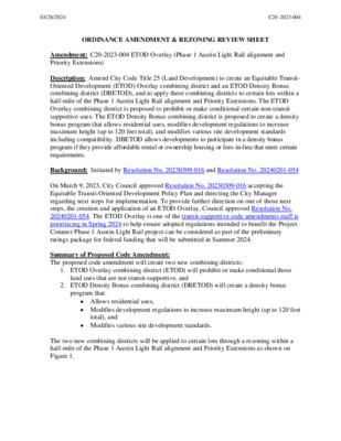
ORDINANCE AMENDMENT & REZONING REVIEW SHEET Amendment: C20-2023-004 ETOD Overlay (Phase 1 Austin Light Rail alignment and Priority Extensions) Description: Amend City Code Title 25 (Land Development) to create an Equitable Transit- Oriented Development (ETOD) Overlay combining district and an ETOD Density Bonus combining district (DBETOD), and to apply these combining districts to certain lots within a half-mile of the Phase 1 Austin Light Rail alignment and Priority Extensions. The ETOD Overlay combining district is proposed to prohibit or make conditional certain non-transit supportive uses. The ETOD Density Bonus combining district is proposed to create a density bonus program that allows residential uses, modifies development regulations to increase maximum height (up to 120 feet total), and modifies various site development standards including compatibility. DBETOD allows developments to participate in a density bonus program if they provide affordable rental or ownership housing or fees-in-lieu that meet certain requirements. Background: Initiated by Resolution No. 20230309-016 and Resolution No. 20240201-054 On March 9, 2023, City Council approved Resolution No. 20230309-016 accepting the Equitable Transit-Oriented Development Policy Plan and directing the City Manager regarding next steps for implementation. To provide further direction on one of those next steps, the creation and application of an ETOD Overlay, Council approved Resolution No. 20240201-054. The ETOD Overlay is one of the transit-supportive code amendments staff is prioritizing in Spring 2024 to help ensure adopted regulations intended to benefit the Project Connect Phase 1 Austin Light Rail project can be considered as part of the preliminary ratings package for federal funding that will be submitted in Summer 2024. Summary of Proposed Code Amendment: The proposed code amendment will create two new combining districts: 1. ETOD Overlay combining district (ETOD) will prohibit or make conditional those land uses that are not transit-supportive, and 2. ETOD Density Bonus combining district (DBETOD) will create a density bonus program that: • Allows residential uses, • Modifies development regulations to increase maximum height (up to 120 feet total), and • Modifies various site development standards. The two new combining districts will be applied to certain lots through a rezoning within a half-mile of the Phase 1 Austin Light Rail alignment and Priority Extensions as shown on Figure 1. 03/28/2024C20-2023-004 Figure 1: Parcels Proposed for Rezoning into the ETOD and DBETOD Combining Districts 03/28/2024C20-2023-004 ETOD Overlay Combining District (ETOD) – Proposed Uses to Prohibit or Make Conditional The following lists delineate land uses that …
ORDINANCE AMENDMENT REVIEW SHEET Amendment: C20-2023-021 Electric Vehicle Charging Land Use Description: Amend City Code Title 25-2 (Zoning) to create a new land use for Electric Vehicle Charging. Background: Initiated by City Council Resolution No. 20230608-082. On June 8, 2023, City Council approved Resolution No. 20230608-082, initiating amendments to City Code Title 25 (Land Development) to create a new land use for “Electric Vehicle Parking.” The resolution directed staff to consider options that would prevent the use from becoming concentrated within activated or residential areas, allow the use through the conditional permit process, and limit the use to General Commercial Services CS or less restrictive zoning districts. Summary of Proposed Code Amendment: Amend City Code 25-2, Subchapter A, Article 4 (Commercial Uses Described) to add a new use of “electric vehicle charging” and to renumber the remaining uses accordingly: (26) Electric Vehicle Charging use is the use of a site for the charging of an electric vehicle (EV), including battery charging stations and rapid charging stations, each as defined by the United States Department of Energy. Amend City Code 25-2-491 (Permitted, Conditional, and Prohibited Uses) to add Electric Vehicle Charging to the use chart. Create a new section of Austin City Code (25-2-819 – Electric Vehicle Charging Use Regulations) to describe additional requirements applicable to the use, including: • Permitting the use in General Commercial Services (CS), Commercial Liquor Sales (CS- 1), Commercial Highway (CH), Industrial Park (IP), Major Industry (MI), Limited Industrial Services (LI), and Research and Development (R&D) zoning districts, with the following requirements: o The use is permitted on sites abutting suburban roadways, highways, hill country roadways, or internal circulation routes. o The use is permitted on sites abutting core-transit corridors, future core-transit corridors, and urban roadways if: The nearest Electric Vehicle Charging use is at least 1,000 feet away; and The site does not exceed 25,000 square feet in area. o The use is conditional on sites abutting core-transit corridors, future core-transit corridors, and urban roadways if: The nearest Electric Vehicle Charging use is less than 1,000 feet away; or 1 03/28/2024C20-2023-021 The site exceeds 25,000 square feet in area. • Permitting the use on a site when the base zoning district is commercial or industrial and a service station use is an existing use or was a previous use for the site unless the use was already converted to a residential, …
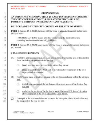
WORKING DRAFT – SUBJECT TO CHANGE JOINT PUBLIC HEARING – VERSION 1 MARCH 29, 2024 ORDINANCE NO. AN ORDINANCE AMENDING TITLE 25 (LAND DEVELOPMENT CODE) OF THE CITY CODE RELATING TO REGULATIONS THAT APPLY TO PROPERTY WITH ONE DWELLING UNIT AND FLAG LOTS. BE IT ORDAINED BY THE CITY COUNCIL OF THE CITY OF AUSTIN: PART 1. Section 25-1-21 (Definitions) of City Code is amended to amend Subdivision (103) to read: (103) SIDE LOT LINE means a lot line intersecting the front lot line and extending a minimum distance of 25 [75] feet. PART 2. Section 25-1-22 (Measurements) of City Code is amended to amend Subsection (A) to read: § 25-1-22 MEASUREMENTS. (A) For MF-1 and less restrictive, lot [Lot] area is the net horizontal area within the lot lines, excluding the portion of the lot that: (1) [that] provides street access, if the lot is a flag lot; or (2) [that] is located below 492.8 feet of elevation above sea level, if the lot is adjacent to Lake Austin. (B) For SF-6 and more restrictive, lot area is the net horizontal area within the lot lines and: (1) (2) includes the portion of the lot that provides street access, if the lot is a flag lot, and excludes the portion of the lot that is located below 492.8 feet of elevation above sea level, if the lot is adjacent to Lake Austin. (C) Lot depth is the horizontal distance between the mid-point of the front lot line and the midpoint of the rear lot line. 1 2 3 4 5 6 7 8 9 10 11 12 13 14 15 16 17 18 19 20 21 22 23 24 25 3/29/2024 11:47 AM HOME 2: 1 Unit Regulations & Flag Lots Page 1 of 11 COA Law Department 26 27 28 29 30 31 32 33 34 35 36 37 38 39 40 41 42 43 44 45 46 47 48 49 50 51 52 WORKING DRAFT – SUBJECT TO CHANGE JOINT PUBLIC HEARING – VERSION 1 MARCH 29, 2024 (D[C]) Except as otherwise provided in this title, lot width is measured at the front setback line and at a distance of 20 [50] feet to the rear of the front setback line. (E[D]) In determining required yards and setbacks for an irregularly shaped lot or a lot bounded by only three lot lines, the rear lot line is: …
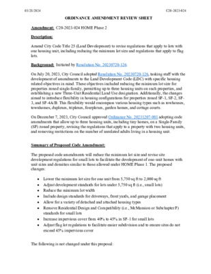
ORDINANCE AMENDMENT REVIEW SHEET Amendment: C20-2023-024 HOME Phase 2 Description: Amend City Code Title 25 (Land Development) to revise regulations that apply to lots with one housing unit, including reducing the minimum lot size and regulations that apply to flag lots. Background: Initiated by Resolution No. 20230720-126. On July 20, 2023, City Council adopted Resolution No. 20230720-126, tasking staff with the development of amendments to the Land Development Code (LDC) with specific housing related objectives in mind. These objectives included reducing the minimum lot size for properties zoned single-family, permitting up to three housing units on such properties, and establishing a new Three-Unit Residential Land Use designation. Additionally, the changes aimed to introduce flexibility in housing configurations for properties zoned SF-1, SF-2, SF- 3, and SF-4A/B. This flexibility would encompass various housing types such as rowhouses, townhomes, duplexes, triplexes, fourplexes, garden homes, and cottage courts. On December 7, 2023, City Council approved Ordinance No. 20231207-001 adopting code amendments that allow up to three housing units, including tiny homes, on a Single-Family (SF) zoned property, revising the regulations that apply to a property with two housing units, and removing restrictions on the number of unrelated adults living in a housing unit. Summary of Proposed Code Amendment: The proposed code amendments will reduce the minimum lot size and revise site development regulations for small lots to facilitate the development of one-unit homes with unit sizes and densities similar to those allowed under HOME Phase 1. The proposed changes: • Lower the minimum lot size for one unit from 5,750 sq ft to 2,000 sq ft • Adjust development standards for lots under 5,750 sq ft (i.e., small lots) • Reduce the minimum lot width • • Allow for a variety of detached and attached housing types • Remove Residential Design and Compatibility (i.e., McMansion or Subchapter F) Include design standards for driveways, front yards, and garage placement standards for small lots Increase impervious cover from 40% to 45% in SF-1 for small lots • • Adjust flag lot regulations to facilitate easier subdivision and to ensure sites do not exceed 45% impervious cover The following is not changed under this proposal: 03/28/2024C20-2023-024 • Minimum lot size of 5,750 sq ft for two-unit and three-unit uses • Regulations for one unit on lots that are 5,750 sq ft or greater in lot size • 45% impervious cover maximum for SF-2 and SF-3 • …
From: John Estrada Sent: Tuesday, April 9, 2024 1:31 PM To: Meredith, Maureen <Maureen.Meredith@austintexas.gov> Subject: Re: April 9 PC - SCC NPCT Rec?: NPA-2023-0020.02_106 Red Bird Ln External Email - Exercise Caution Hi Maureen! I'd like to add this to the late material for the Planning Commission. Thank you! John Estrada 4/9/24 Greetings everyone! I am writing today in regards to items 9 & 10 on the agenda for Tuesday, April 9th. I am neither for nor against this project. Again, my main concern is what is already happening to Blue Bird Lane and the 300 block of Red Bird Lane, and how the current situation could be exacerbated by this project. The concern? The explosion in street parking and through traffic on Blue Bird and Red Bird. When this new project is completed, it will surely bring more of both to the area. All I am asking for is Transportation staff to take a look at what is going on and make the clear and easy decision. Install “No Parking” signs on Blue Bird and the 300 block of Red Bird. The 200 block of Red Bird already has “No Parking” signs! And it’s clear by the footage below why… https://youtu.be/1yi4u50srNc Thumbnail below Imagine a hip restaurant or space in the new development (it is mixed use after all). What if there’s an event there AS WELL as an event at Sagebrush. You’ll get more of this. Why is it so bad here already? In my previous time in front of you all, I mentioned that this stretch of South Congress (seen highlighted in red) added a sidewalk and bike lanes, and that all the parking there was removed. In addition, overflow parking from Sagebrush was using the area that will become this new proposed project (seen highlighted in yellow). Now that all of that area is gone, parking is overflowing heavily into the neighborhood. It doesn’t help that the area highlighted in orange, Sagebrush, used to have a lot more parking when other businesses occupied the space. It was even mentioned in a list of code violations CV-2021-158306. The issue was never remedied in regards to that. There are times when public safety and well being are so clear and paramount that a government acts. This is one of those cases. Thank you!
1405 Hillmont Street Austin, Texas 78704 Phone: 512-326-8880 e-mail: lauren@glenrose.com April 3, 2024 Chair Claire Hempel Vice Chair Awais Azhar Secretary Greg Anderson Parliamentarian Alice Woods Board Member Patrick Howard Board Member Jennifer Mushtaler Board Member Felicity Maxwell Board Member Grayson Cox Board Member Adam Haynes Board Member Nadia Barrera-Ramirez Board Member Danielle Skidmore Board Member Ryan Johnson Board Member Alberta Phillips Board Member (ex-officio) Jessica Cohen Board Member (ex-officio) Candace Hunter Subject: Recommendation to Deny Zoning Request for Zoning Case NPA-2023- 0020.02_106 & 118 Red Bird Lane Dear City of Austin Planning Commission, I am writing on behalf of Bird Streets of Pleasant Hill neighborhood group to recommend denial of the requested zoning of CS-MU-V-DB90-CO-NP (Density Bonus 90 combining district) in the subject zoning case. My recommendation is based on my review of these documents: 2023; • Civil Site Development Plans for 5412 S Congress Mixed-Use dated December • City of Austin Master Comment Report for Case Number SP-2023-0495C, Revision # 00 dated February 26, 2024; • City of Austin Technical Memorandum regarding Drainage Pattern and Public Infrastructure around Your Property to Mr. Bradford Massingill III, dated September 25, 2023; • An Environmental Resource Inventory Waiver Request Form filed for the project and approved by Watershed Protection Department; Glenrose Engineering, Inc. Texas Board of Professional Engineers Number F4092 glenrose.com City of Austin Planning Commission April 3, 2024 Page 2 of 3 • Relevant maps and Geographical Information System (GIS) data regarding topography, soils, and drainage associated with the proposed zoning changes. Based on my review of these documents, the proposed project will contribute additional storm flows to local flooding. It will inadequately protect sensitive environmental features associated with the proposed development location. Contribution to Local Flooding The proposed project would be located within the Williamson Creek watershed, upstream and less than a mile west of Interstate Highway 35. Based on information submitted by the applicant, existing pervious area on the site is 1.94 acres, which constitutes nearly 72 percent of the site area. Under the proposed development plan, the pervious area would be reduced to 0.87 acres, which is only 36 percent of the site. Pervious areas allow storm runoff to infiltrate into soil. This infiltration reduces flooding and erosion. It sustains the natural flow of water into seeps, springs, and creeks between storm events. Rainfall infiltration into soil also sustains trees during drought and reduces peak urban temperatures. …
From: Michael Phalan <> Sent: Tuesday, April 9, 2024 10:15 AM To: Chaffin, Heather <Heather.Chaffin@austintexas.gov> Subject: Re: FW: April 9, 2024 Planning Commission Agenda Hi Heather, Thanks for forwarding this to me. I would like to sign up to speak against this project. Honestly, between my kids, and the eclipse, I have dropped the ball... I spoke to several of my neighbors on the 2700 block of willow and 2700 block of canterbury, and they agree that they would rather this project be located elsewhere. I just have not followed through with actually getting their signatures on anything. Oh well, I will sign up to speak tonight. Thank you for the info Michael Phalan From: Sandra Boone Sent: Tuesday, April 9, 2024 9:37 AM To: Chaffin, Heather <Heather.Chaffin@austintexas.gov> Cc: Michael Phalan < >; Jayashree Krishnan <> Subject: Re: FW: April 9, 2024 Planning Commission Agenda Ms, Chaffin, I appreciate your help with this Permit application. I wanted to let you know that the Holly Neighborhood Association will not be taking a position on the application, and will not be requesting speaking time. Sandi Boone President Holly Neighborhood Association ec: Holly NA Board From: Thomas, Eric <Eric.Thomas@austintexas.gov> Sent: Friday, April 5, 2024 4:59 PM To: Sandra Boone <>; LDC Updates <LDCUpdates@austintexas.gov> Cc: David Kinsey <>; Chaffin, Heather <Heather.Chaffin@austintexas.gov>; Harden, Joi <Joi.Harden@austintexas.gov> Subject: RE: Proposed EV Charging Site ordinance & Voltare permit application Good afternoon Ms. Boone, Thank you for your email. I apologize for the issues with my phone, as I recently transferred departments and am working through several technical challenges. I will allow Heather to respond to the questions related to the conditional use permits that are currently going through the review/permitting process (or forward to the correct staff member). During the development of the Electric Vehicle (EV) Charging land use code amendment, Planning Department staff coordinated with applicable departments to ensure that the proposal balances environmental benefits with land use considerations/planning principals, while also meeting all safety requirements. Among other departments, we met with Austin Energy, DSD, Transportation and Public Works, and Austin Fire Department throughout the process to receive acceptance/approval of the ordinance. One concrete example of interdepartmental collaboration is the prohibition of the use underground, which was recommended as a safety precaution by the fire department. Please note that each EV Charging use will require a site plan, at which point all applicable city code requirements will …
City of Austin Plann ing Departmen t P.O. Box 1088, Austin, TX 78767 -1088 (512) 974-3100 ♦ Fax (512) 974-3112 ♦ h t t ps://www.aust i nt exas.g ov/depar t ment /planni ng -depar t ment MEMORANDUM TO: FROM: Todd W. Shaw, Chair & Planning Commission Members DATE: March 18, 2024 Maureen Meredith, Senior Planner, Inclusive Planning Division Planning Department RE: NPA-2018-0021.02_5100, 5208, 50150 E. Oltorf Street & 2424 & 2424 ½ Riverside Farms Rd The applicant requests an indefinite postponement of the above-referenced case. See Ferris Clement’s email. This postponement request was made in a timely manner and meets the Planning Commission’s policy. Attachment: Ferris Clements’ Email Plan Amendment Map The City of Austin is committed to compliance with the Americans with Disabilities Act and will provide reasonable modifications and equal access to communications upon request. 1 of 302 NPA-2018-0021.02 - Skyline Oltorf Mixed Use; District 3 From: Ferris Clements Sent: Monday, March 18, 2024 5:37 PM To: Meredith, Maureen <Maureen.Meredith@austintexas.gov> Subject: RE: Reason for Indef PP for NPA-2018-0021.02_Skyline/Oltorf External Email - Exercise Caution Maureen, The Applicant is requesting an indefinite postponement to allow additional time to work on its plans for the Property. Thanks, Ferris G. FERRIS CLEMENTS III Attorney Armbrust & Brown, PLLC Email: fclements@abaustin.com Phone: 512-435-2337 100 Congress Avenue, Suite 1300 Austin, TX 78701 www.abaustin.com The City of Austin is committed to compliance with the Americans with Disabilities Act and will provide reasonable modifications and equal access to communications upon request. 2 of 302 NPA-2018-0021.02 - Skyline Oltorf Mixed Use; District 3 The City of Austin is committed to compliance with the Americans with Disabilities Act and will provide reasonable modifications and equal access to communications upon request. 3 of 302 NPA-2018-0021.02 - Skyline Oltorf Mixed Use; District 3