REGULAR MEETING OF THE PLANNING COMMISSION TUESDAY, JULY 14, 2026, AT 6 P.M. AUSTIN CITY HALL, COUNCIL CHAMBERS, ROOM 1001 301 WEST 2ND STREET AUSTIN, TEXAS Some members of the Planning Commission may be participating by videoconference. The meeting may be viewed online at: http://www.austintexas.gov/page/watch-atxn-live Public comment will be allowed in-person or remotely via telephone. Speakers may only register to speak on an item once either in-person or remotely and will be allowed up to three minutes to provide their comments. Registration no later than 2 p.m. on the day of the meeting is required for remote participation by telephone. To register to speak remotely, please use the QR code or link at the end of this document. If you have questions regarding speaker registration, please contact Ella Garcia, Staff Liaison, at LandUseLiaison@austintexas.gov or by phone at 512-978-0821. CURRENT COMMISSIONERS: Alice Woods, Chair (District 2) Casey Haney, Vice Chair (Mayor’s Representative) Felicity Maxwell, Secretary (District 5) Imad Ahmed, Parliamentarian (District 6) Anna Lan (Mayor’s Representative) Vacant (Mayor’s Representative) Chris Gannon (District 1) EX-OFFICIO MEMBERS: Nadia Barrera-Ramirez (District 3) Brian Bedrosian (District 4) Adam Powell (District 7) Peter Breton (District 8) Danielle Skidmore (District 9) Joshua Hiller (District 10) Jeffery Bowen, Chair of Board of Adjustment TC Broadnax, City Manager Candace Hunter, A.I.S.D. Board of Trustees Richard Mendoza, Director of Transportation and Public Works Staff Liaison: Ella Garcia, 512-978-0821 Attorney: Steve Maddoux, 512-974-6080 Page 1 of 9 AGENDA CALL TO ORDER PUBLIC COMMUNICATION: GENERAL The first four speakers signed up prior to the meeting being called to order will each be allowed a three-minute allotment to address their concerns regarding items not posted on the agenda. APPROVAL OF MINUTES 1. Approve the minutes of the Planning Commission regular meeting on Tuesday, June 23, 2026. PUBLIC HEARINGS 2. Plan Amendment: NPA-2026-0019.01 - 3701 Speedway, 3703 Speedway and 104 East Location: 37th Street NPA; District 9 3701 and 3703 Speedway and 104 East 37th Street, Waller Creek Watershed; Central Austin Combined (North University) Neighborhood Planning Area Owner/Applicant: La Familia Partnership LTD, a Texas limited partnership Agent: Request: Staff Rec.: Staff: Dubois Bryant & Campbell, LLP (David Hartman) Mixed Use/Office to Mixed Use land use Recommended Maureen Meredith, 512-974-2695, maureen.meredith@austintexas.gov Austin Planning 3. Rezoning: Location: C14-2026-0020 - 3701 Speedway, 3703 Speedway and 104 East 37th Street Rezoning; District 9 3701 and 3703 Speedway and 104 East 37th Street, Waller Creek Watershed; Central Austin Combined …
SPEAKER REGISTRATION All participants wishing to address the commission must register to speak. Public participation is available by teleconference or in-person. Presentations and handouts are requested to be e- mailed by 1:00 p.m. on the day of the meeting. TELECONFERNCE REGISTRATION Registration for participation by teleconference closes at 2:00 p.m., the day of the meeting. Teleconference code and additional information to be provided after the closing of the teleconference registration period. IN-PERSON REGISTRATION While in-person registrants are encouraged to register in advance of the meeting, in-person registration closes at 5:30 p.m., the day of the meeting. Please scan the QR code below with a mobile device or click on the link below. Mobile devices will also be available at the meeting for public use for the purpose of speaker registration. SPEAKER DONATION OF TIME For discussion cases, speaker donation of time is an available option for in-person participants. Both the registered speaker donating time and the speaker recipient must be present when the public hearing is conducted. See chart below regarding speaker time allotments. SPEAKING ORDER The speaking order is determined by the order in which individuals register to speak and is conducted on a first-come, first-served basis. If multiple speakers register as the Primary Speaker, the first to register is allotted the additional speaking time. Participants who are part of a group or organization and wish to request a specific speaking order must contact Ella Garcia, Staff Liaison, at LandUseLiaison@austintexas.gov or 512-978-0821 as soon as possible, and no later than 2:00 p.m. on the day of the meeting. Click on the link below or scan the QR code and submit the form to register to speak. Speakers should submit a separate registration form for each item of interest. https://forms.office.com/g/W9r6dSSkUG SPEAKER TESTIMONY TIME ALLOCATION PUBLIC HEARING CASES – CONSENT ITEMS *Donation of time is not an option for consent items. All speakers in favor or opposed 2 minutes each PUBLIC HEARING CASES – DISCUSSION ITEMS The applicant/speaker designated by the applicant or the primary speaker in favor Primary speaker opposed All other speakers in favor or opposed 5 minutes; up to 9 minutes total with donated time, plus a 2 minute rebuttal 5 minutes; up to 9 minutes total with donated time 2 minutes each; up to 6 minutes total with donated time DISCUSSION POSTPONEMENT *Donation of time is not an option for discussion postponement. The applicant/speaker designated by the …
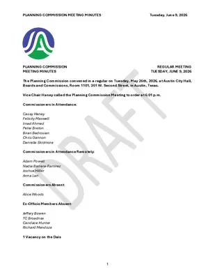
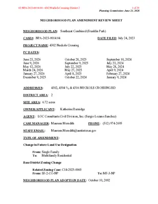
PLANNING COMMISSION MEETING MINUTES Tuesday, June 23, 2026 PLANNING COMMISSION MEETING MINUTES REGULAR MEETING TUESDAY, JUNE 23, 2026 The Planning Commission convened in a regular on Tuesday, June 23, 2026, at Austin City Hall, Boards and Commissions, Room 1101, 301 W. Second Street, in Austin, Texas. Chair Woods called the Planning Commission Meeting to order at 6:01 p.m. Commissioners in Attendance: Alice Woods, Chair Casey Haney, Vice Chair Imad Ahmed, Parliamentarian Brian Bedrosian Chris Gannon Anna Lan Adam Powell Danielle Skidmore Commissioners in Attendance Remotely: Nadia Barrera-Ramirez Peter Breton Joshua Hiller Commissioners Absent: Felicity Maxwell, Secretary Ex-Officio Members Absent: Jeffery Bowen TC Broadnax Candace Hunter Richard Mendoza 1 Vacancy on the Dais 1 PLANNING COMMISSION MEETING MINUTES Tuesday, June 23, 2026 PUBLIC COMMUNICATION: GENERAL Philip Wiley – Summer readings: City planning progress APPROVAL OF MINUTES 1. Approve the minutes of the Planning Commission regular meeting on Tuesday, June 9, 2026. The minutes from the meeting of Tuesday, June 9, 2026, were approved on the consent agenda on Vice Chair Haney’s motion, Commissioner Powell’s second, on an 11-0 vote. 1 vacancy on the dais. Secretary Maxwell was absent. PUBLIC HEARINGS 2. Plan Amendment: NPA-2023-0014.04 - 4302 Nuckols Crossing; District 2 Location: 4302, 4304 ½, and 4316 Nuckols Crossing Road, Williamson Creek Watershed; Southeast Combined (Franklin Park) Neighborhood Planning Area Owner/Applicant: Katherine Barnidge Agent: Request: Staff Rec.: Staff: LOC Consultants Civil Division (Sergio Lozano-Sanchez, P.E.) Single Family to Multifamily Residential land use Recommended Maureen Meredith, 512-974-2695, maureen.meredith@austintexas.gov Austin Planning The public hearing was closed on Commissioner Gannon’s motion, Commissioner Powell’s second, on an 11-0 vote. 1 vacancy on the dais. Secretary Maxwell was absent. The motion to approve Staff’s recommendation of Multifamily Residential land use for NPA-2023-0014.04 - 4302 Nuckols Crossing; District 2, located at 4302, 4304 ½, and 4316 Nuckols Crossing Road, was approved on Commissioner Skidmore’s motion, Parlimantarian’s second, on a 9-0-2 vote. Chair Woods and Vice Chair Haney abstained. 1 vacancy on the dais. Secretary Maxwell was absent. 3. Rezoning: Location: C14-2025-0065 - 4302 Nuckols Crossing; District 2 4302, 4304 ½, and 4316 Nuckols Crossing Road, Williamson Creek Watershed; Southeast Combined (Franklin Park) Neighborhood Planning Area Owner/Applicant: Katherine Barnidge Agent: Request: Staff Rec.: Staff: LOC Consultants Civil Division (Sergio Lozano-Sanchez, P.E.) SF-2-CO-NP to MF-3-NP Staff recommends MF-3-CO-NP Nancy Estrada, 512-974-7617, nancy.estrada@austintexas.gov Austin Planning The public hearing was closed on Commissioner Gannon’s motion, Commissioner Powell’s second, on an 11-0 vote. …
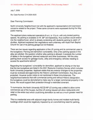
NEIGHBORHOOD PLAN AMENDMENT REVIEW SHEET NEIGHORHOOD PLAN: Central Austin Combined (North University) CASE#: NPA-2026-0019.01 DATE FILED: March 25, 2026 PROJECT NAME: 3701 Speedway, 3703 Speedway and 104 E. 37th Street PC DATE: July 14, 2026 June 23, 2026 ADDRESS/ES: 3701, 3703 Speedway and 104 E. 37th Street DISTRICT AREA: 9 SITE AREA: 0.2769 OWNER/APPLICANT: La Familia Partnership LTD, a Texas limited partnership AGENT: Dubois Bryant & Campbell, LLP (David Hartman) CASE MANAGER: Maureen Meredith PHONE: (512) 974-2695 STAFF EMAIL: Maureen.Meredith@austintexas.gov TYPE OF AMENDMENT: Change in Future Land Use Designation From: Mixed Use/Office To: Mixed Use Base District Zoning Change Related Zoning Case: C14-2026-0020 From: LO-NCCD-ETOD-DBETOD-NP To: LR-NCCD-ETOD-DBETOD-NP NEIGHBORHOOD PLAN ADOPTION DATE: August 26, 2004 CITY COUNCIL DATE: TBD ACTION: PLANNING COMMISSION RECOMMENDATION: July 14, 2026 – (action pending) 02 NPA-2026-0019.01 - 3701 Speedway, 3703 Speedway and 104 E. 37th St. NPA; District 91 of 31 June 23, 2026 – Postponed to July 14, 2026 on the consent agenda at the request of the Neighborhood. [C. Haney – 1st; A. Powell – 2nd] Vote: 11- 0 [F. Maxwell absent. One vacancy on the dais]. STAFF RECOMMENDATION: Staff supports the Applicant’s request for Mixed Use land use. BASIS FOR STAFF’S RECOMMENDATION: The subject tract currently has Mixed Use/Office land use and has three bungalows that are proposed to be developed with a tract directly to the north that has Mixed Use land use. Staff supports the applicant’s request for Mixed Use land use on this property. The property is proposed to be redeveloped with neighborhood- serving commercial uses that is walkable and in scale with the surrounding land uses. Staff believe the reqeust for Mixed Use supports the Central Austin Combined Neighborhood Plan by providing additional neighborhood-serving commercial uses within walking distance to residential areas. 02 NPA-2026-0019.01 - 3701 Speedway, 3703 Speedway and 104 E. 37th St. NPA; District 92 of 31 LAND USE DESCRIPTIONS: EXISTING LAND USE: Mixed Use/Office - An area that is appropriate for a mix of residential and office uses. Purpose 1. Accommodate mixed use development in areas that are not appropriate for general commercial development; and 2. Provide a transition from residential use to non residential or mixed use. Application ‐ 1. Appropriate for areas such as minor corridors or local streets adjacent to commercial areas; 2. May be used to encourage commercial uses to transition to residential use; and 3. Provide limited opportunities for live/work residential …
03 C14-2026-0020 - 3701 Speedway, 3703 Speedway and 104 E. 37th St. Rezoning; District 91 of 2 03 C14-2026-0020 - 3701 Speedway, 3703 Speedway and 104 E. 37th St. Rezoning; District 92 of 2
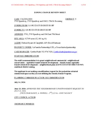
ZONING CHANGE REVIEW SHEET CASE: C14-2026-0020 3701 Speedway, 3703 Speedway and 104 E. 37th St. Rezoning DISTRICT: 9 ZONING FROM: LO-NCCD-ETOD-DBETOD-NP ZONING TO: LR-NCCD-ETOD-DBETOD-NP ADDRESS: 3701, 3703 Speedway and 104 East 37th Street SITE AREA: 0.2769 acres (12, 061 sq. ft.) AGENT: Dubois Bryant & Campbell, LLP (David Hartman) PROPERTY OWNER: La Familia Partnership LTD, a Texas limited partnership CASE MANAGER: Cynthia Hadri 512-974-7620, Cynthia.hadri@austintexas.gov STAFF RECOMMENDATION: The staff recommendation is to grant neighborhood commercial - neighborhood conservation – equitable transit-oriented development – density bonus equitable transit-oriented development – neighborhood plan (LR-NCCD-ETOD-DBETOD-NP) combined district zoning. The applicant is not seeking a modification request for the pedestrian-oriented commercial space as they are not utilizing the Density Bonus Program. PLANNING COMMISSION ACTION / RECOMMENDATION: July 14, 2026: June 23, 2026: APPROVED THE NEIGHBORHOOD’S POSTPONEMENT REQUEST TO JULY 14, 2026. [VICE CHAR HANEY; A. POWELL - 2ND] (12-0) - ONE VACANCY CITY COUNCIL ACTION: ORDINANCE NUMBER: 03 C14-2026-0020 - 3701 Speedway, 3703 Speedway and 104 E. 37th St. Rezoning; District 91 of 18 C14-2026-0020 ISSUES: 2 On March 9, 2023, City Council approved Resolution No. 20230309-016 accepting the Equitable Transit-Oriented Development Policy Plan and directing the City Manager regarding next steps for implementation of items intended to benefit the Project Connect Phase 1 Austin Light Rail project. This included development of code amendments to support transit in May of 2024 (Ordinance No. 20240516-005), including creation of the ETOD combining district (restrictions on non-transit supportive uses) and the DBETOD combining district (allowing residential use, and relaxing some development standards including increased height in exchange for income-restricted housing). Properties within one half-mile of the Phase 1 Austin Light Rail alignment and Priority Extensions were included within this overlay, and certain properties were rezoned through a City-initiated process to include the ETOD and DBETOD combining districts. Further, properties rezoned with DBETOD combining district were categorized into Subdistrict 1 (maximum allowable height of 120 feet) or Subdistrict 2 (maximum allowable height of 90 feet), generally based on property distance of ¼-mile or ½-mile from the Phase 1 alignment, respectively. However, that rezoning process did not modify any base district zoning or any combining district zoning, which is the subject of this request. CASE MANAGER COMMENTS: The property in question is approximately 0.27 acres, currently zoned limited office - neighborhood conservation - equitable transit-oriented development – density bonus equitable transit-oriented development – neighborhood plan (LO-NCDD-ETOD-DBETOD- NP) combined district …
City of Austin Austin Planning 6310 Wilhelmina Delco Drive, Austin, TX 78752 P.O. Box 1088, Austin, TX 78767 -1088 (512) 974-2000 ♦ h ttp s:/ / w w w.au st in tex a s .g ov / d epa r tm e n t/ plan n in g - de part men t MEMORANDUM TO: Chair & Planning Commission Members FROM: Maureen Meredith, Senior Planner, Long-Range Planning Division Jonathan Tomko, Principal Planner, Current Planning Division DATE: July 7, 2026 RE: NPA-2024-0016.05 & C14-2025-0005_ 500 Shady Lane Govalle/Johnston Terrace Combined Neighborhood Planning Area The Applicant requests an indefinite postponement of the above-referenced cases. Please see Alice Glasco’s attached letter dated June 29, 2026. The postponement request was made in a timely manner and meets the Planning Commission’s policy. Attachments: Alice Glasco’s letter Plan Amendment Map Zoning Map 04 NPA-2024-0016.05 - Shady Lane; District 31 of 5 04 NPA-2024-0016.05 - Shady Lane; District 32 of 5 04 NPA-2024-0016.05 - Shady Lane; District 33 of 5 04 NPA-2024-0016.05 - Shady Lane; District 34 of 5 04 NPA-2024-0016.05 - Shady Lane; District 35 of 5
City of Austin Austin Planning 6310 Wilhelmina Delco Drive, Austin, TX 78752 P.O. Box 1088, Austin, TX 78767 -1088 (512) 974-2000 ♦ h ttp s:/ / w w w.au st in tex a s .g ov / d epa r tm e n t/ plan n in g - de part men t MEMORANDUM TO: Chair & Planning Commission Members FROM: Maureen Meredith, Senior Planner, Long-Range Planning Division Jonathan Tomko, Principal Planner, Current Planning Division DATE: July 7, 2026 RE: NPA-2024-0016.05 & C14-2025-0005_ 500 Shady Lane Govalle/Johnston Terrace Combined Neighborhood Planning Area The Applicant requests an indefinite postponement of the above-referenced cases. Please see Alice Glasco’s attached letter dated June 29, 2026. The postponement request was made in a timely manner and meets the Planning Commission’s policy. Attachments: Alice Glasco’s letter Plan Amendment Map Zoning Map 05 C14-2025-0005 - Shady Lane; District 31 of 5 05 C14-2025-0005 - Shady Lane; District 32 of 5 05 C14-2025-0005 - Shady Lane; District 33 of 5 05 C14-2025-0005 - Shady Lane; District 34 of 5 05 C14-2025-0005 - Shady Lane; District 35 of 5
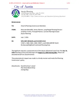
City of Austin Austin Planning 6310 Wilhelmina Delco Drive, Austin, TX 78752 P.O. Box 1088, Austin, TX 78767-1088 (512) 974-2000 ♦ h ttp s:/ / w w w.au st in tex a s .g ov / d epa r tm e n t/ plan n in g - de part men t MEMORANDUM TO: Chair & Planning Commission Members FROM: Maureen Meredith, Senior Planner, Long-Range Planning Division Jonathan Tomko, Principal Planner, Current Planning Division Austin Planning DATE: July 7, 2026 RE: NPA-2025-0018.02 and C14-2025-0115 5768 ½, 5800, 5826, 5900, 5900 ½, and 5908 AIRPORT BLVD Brentwood/Highland Combined Planning Area The Applicant requests a postponement of the above-referenced cases from the July 14, 2026 Planning Commission hearing to the August 11, 2026 hearing date. Please see attached email from David Hartman. The postponement request was made in a timely manner and meets the Planning Commission’s policy. Attachments: David Hartman’s email Plan Amendment Map Zoning Map The City of Austin is committed to compliance with the Americans with Disabilities Act and will provide reasonable modifications and equal access to communications upon request. 06 NPA-2025-0018.02 - Airport and Koenig Multifamily; District 41 of 4 From: David Hartman < Sent: Tuesday, June 30, 2026 4:04 PM To: Meredith, Maureen <Maureen.Meredith@austintexas.gov> Cc: Tomko, Jonathan <Jonathan.Tomko@austintexas.gov> Subject: RE: Postponement? July 14 PC hrng: NPA-2025-0018.02_Airport/Koenig - virtual community mtg. date Hi Meredith: As mentioned in the related email I sent just now please postpone these cases to the 8- 11-26 PC mtg. For the Virtual Community mtg., let me know some dates after 7-13-26 that work for you for this virtual Community mtg. that will provide enough advance time for the cases to be ready for PC action at the 8-11-26 PC mtg. Thanks, David David Hartman Partner DuBOIS BRYANT & CAMPBELL 303 Colorado, Suite 2300 Austin, TX 78701 O:(512) 457-8000 D:(512) 685-3409 M:(512) 297-5640 F:(512) 457-8008 bio vcard The City of Austin is committed to compliance with the Americans with Disabilities Act and will provide reasonable modifications and equal access to communications upon request. 06 NPA-2025-0018.02 - Airport and Koenig Multifamily; District 42 of 4 The City of Austin is committed to compliance with the Americans with Disabilities Act and will provide reasonable modifications and equal access to communications upon request. 06 NPA-2025-0018.02 - Airport and Koenig Multifamily; District 43 of 4 The City of Austin is committed to compliance with the Americans with Disabilities Act …
City of Austin Austin Planning 6310 Wilhelmina Delco Drive, Austin, TX 78752 P.O. Box 1088, Austin, TX 78767-1088 (512) 974-2000 ♦ h ttp s:/ / w w w.au st in tex a s .g ov / d epa r tm e n t/ plan n in g - de part men t MEMORANDUM TO: Chair & Planning Commission Members FROM: Maureen Meredith, Senior Planner, Long-Range Planning Division Jonathan Tomko, Principal Planner, Current Planning Division Austin Planning DATE: July 7, 2026 RE: NPA-2025-0018.02 and C14-2025-0115 5768 ½, 5800, 5826, 5900, 5900 ½, and 5908 AIRPORT BLVD Brentwood/Highland Combined Planning Area The Applicant requests a postponement of the above-referenced cases from the July 14, 2026 Planning Commission hearing to the August 11, 2026 hearing date. Please see attached email from David Hartman. The postponement request was made in a timely manner and meets the Planning Commission’s policy. Attachments: David Hartman’s email Plan Amendment Map Zoning Map 07 C14-2025-0115 - Airport and Koenig Multifamily; District 41 of 4 From: David Hartman < Sent: Tuesday, June 30, 2026 4:04 PM To: Meredith, Maureen <Maureen.Meredith@austintexas.gov> Cc: Tomko, Jonathan <Jonathan.Tomko@austintexas.gov> Subject: RE: Postponement? July 14 PC hrng: NPA-2025-0018.02_Airport/Koenig - virtual community mtg. date Hi Meredith: As mentioned in the related email I sent just now please postpone these cases to the 8- 11-26 PC mtg. For the Virtual Community mtg., let me know some dates after 7-13-26 that work for you for this virtual Community mtg. that will provide enough advance time for the cases to be ready for PC action at the 8-11-26 PC mtg. Thanks, David David Hartman Partner DuBOIS BRYANT & CAMPBELL 303 Colorado, Suite 2300 Austin, TX 78701 O:(512) 457-8000 D:(512) 685-3409 M:(512) 297-5640 F:(512) 457-8008 bio vcard 07 C14-2025-0115 - Airport and Koenig Multifamily; District 42 of 4 07 C14-2025-0115 - Airport and Koenig Multifamily; District 43 of 4 07 C14-2025-0115 - Airport and Koenig Multifamily; District 44 of 4
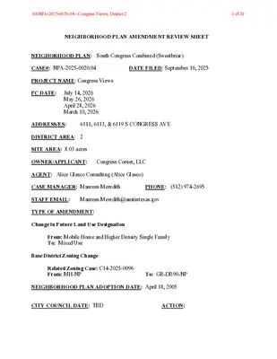
NEIGHBORHOOD PLAN AMENDMENT REVIEW SHEET NEIGHORHOOD PLAN: South Congress Combined (Sweetbriar) CASE#: NPA-2025-0020.04 DATE FILED: September 16, 2025 PROJECT NAME: Congress Views PC DATE: July 14, 2026 May 26, 2026 April 28, 2026 March 10, 2026 ADDRESS/ES: 6111, 6113, & 6119 S CONGRESS AVE DISTRICT AREA: 2 SITE AREA: 8.03 acres OWNER/APPLICANT: Congress Corner, LLC AGENT: Alice Glasco Consulting (Alice Glasco) CASE MANAGER: Maureen Meredith PHONE: (512) 974-2695 STAFF EMAIL: Maureen.Meredith@austintexas.gov TYPE OF AMENDMENT: Change in Future Land Use Designation From: Mobile Home and Higher Density Single Family To: Mixed Use Base District Zoning Change Related Zoning Case: C14-2025-0096 From: MH-NP To: GR-DB90-NP NEIGHBORHOOD PLAN ADOPTION DATE: April 18, 2005 CITY COUNCIL DATE: TBD ACTION: 08 NPA-2025-0020.04 - Congress Views; District 21 of 20 PLANNING COMMISSION RECOMMENDATION: July 14, 2026 – (action pending) May 26, 2026 – Postponed July 14, 2026 on the consent agenda at the request of the Staff. [A. Powell – 1st; F. Maxwell – 2nd] Vote: 12-0 [One vacancy on the dais]. April 28, 2026 – Postponed to May 26, 2026 on the consent agenda at the request of the Planning Commission. [C. Haney – 1st; D. Skidmore – 2nd] Vote: 12-0 [One vacancy on the dais]. March 10, 2026 – Postponed to April 28, 2028 on the consent agenda at Staff’s request. [B. Bedrosian – 1st; N. Barrera-Ramirez – 2nd] Vote: 11-0 [C. Haney absent. One vacancy on the dais]. STAFF RECOMMENDATION: To support the Applicant’s request for Mixed Use land use. BASIS FOR STAFF’S RECOMMENDATION: Staff supports the Applicant’s request for Mixed Use land use because the property is located along South Congress Avenue, which is identified as an activity corridor in the Imagine Austin Comprehensive Plan where mixed use developments are encouraged. South Congress Avenue also has existing public transportation and is proposed for a light rail line. There is Mixed Use land uses to the north, east, south, and west of the property. The applicant proposes to build a mixed-use development with ground-floor retail with approximately 350 apartment dwelling units. The development will provide either 12% of the units affordable at 60% MFI or 10% of the units affordable at 50% MFI. The proposed development will help to meet the Austin Strategic Housing Blueprint’s goal of creating 135,000 housing units throughout the City by 2027 with 60,000 designated as affordable for households at or below 80% of medium family income (MFI). 08 …
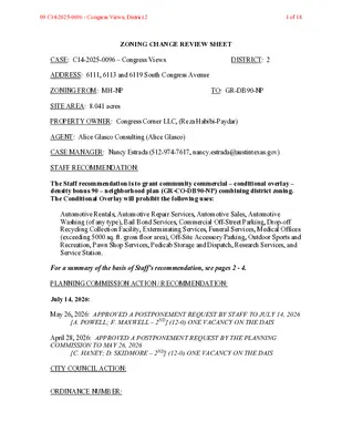
ZONING CHANGE REVIEW SHEET CASE: C14-2025-0096 – Congress Views DISTRICT: 2 ADDRESS: 6111, 6113 and 6119 South Congress Avenue ZONING FROM: MH-NP TO: GR-DB90-NP SITE AREA: 8.041 acres PROPERTY OWNER: Congress Corner LLC, (Reza Habibi-Paydar) AGENT: Alice Glasco Consulting (Alice Glasco) CASE MANAGER: Nancy Estrada (512-974-7617, nancy.estrada@austintexas.gov) STAFF RECOMMENDATION: The Staff recommendation is to grant community commercial – conditional overlay – density bonus 90 – neighborhood plan (GR-CO-DB90-NP) combining district zoning. The Conditional Overlay will prohibit the following uses: Automotive Rentals, Automotive Repair Services, Automotive Sales, Automotive Washing (of any type), Bail Bond Services, Commercial Off-Street Parking, Drop-off Recycling Collection Facility, Exterminating Services, Funeral Services, Medical Offices (exceeding 5000 sq. ft. gross floor area), Off-Site Accessory Parking, Outdoor Sports and Recreation, Pawn Shop Services, Pedicab Storage and Dispatch, Research Services, and Service Station. For a summary of the basis of Staff’s recommendation, see pages 2 - 4. PLANNING COMMISSION ACTION / RECOMMENDATION: July 14, 2026: May 26, 2026: APPROVED A POSTPONEMENT REQUEST BY STAFF TO JULY 14, 2026 [A. POWELL; F. MAXWELL – 2ND] (12-0) ONE VACANCY ON THE DAIS April 28, 2026: APPROVED A POSTPONEMENT REQUEST BY THE PLANNING COMMISSION TO MAY 26, 2026 [C. HANEY; D. SKIDMORE – 2ND] (12-0) ONE VACANCY ON THE DAIS CITY COUNCIL ACTION: ORDINANCE NUMBER: 09 C14-2025-0096 - Congress Views; District 21 of 18 C14-2025-0096 ISSUES: Page 2 On November 20, 2025, City of Austin staff sponsored a virtual community meeting to provide an opportunity for the neighborhood plan contact team, nearby residents, property owner, and any other interested parties to discuss the proposed rezoning and the neighborhood plan amendment request. CASE MANAGER COMMENTS: The subject rezoning area consists of approximately 8.04 acres and is located at the northeast corner of South Congress Avenue and North Bluff Drive, in proximity to Stassney Lane to the north and William Cannon to the south. The site was previously developed as a mobile home park; however, no mobile home residences remain on the property, and approximately 48 mobile home pad sites are still present. The property received its current mobile home residence – neighborhood plan (MH-NP) combining district zoning in 2019 following the City Council’s adoption of a resolution initiating the rezoning of existing mobile home parks to MH district zoning. Since the subject area is located along the South Congress Activity Corridor, it is surrounded by commercial services and multifamily mixed use developments. Directly north …
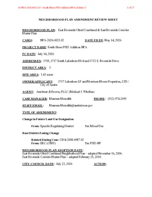
NEIGHBORHOOD PLAN AMENDMENT REVIEW SHEET NEIGHORHOOD PLAN: East Riverside/Oltorf Combined & East Riverside Corridor Master Plan CASE#: NPA-2026-0021.02 DATE FILED: May 14, 2026 PROJECT NAME: South Shore PUD Addition NPA PC DATE: July 14, 2026 ADDRESS/ES: 1705, 1717 South Lakeshore Blvd and 1712 E. Riverside Drive DISTRICT AREA: 3 SITE AREA: 1.43 acres OWNER/APPLICANT: 1717 Lakeshore LP and Morrison-Moore Properties, LTD / City of Austin AGENT: Armbrust & Brown, PLLC (Michael J. Whellan) CASE MANAGER: Maureen Meredith PHONE: (512) 974-2695 STAFF EMAIL: Maureen.Meredith@austintexas.gov TYPE OF AMENDMENT: Change in Future Land Use Designation From: Specific Regulating District To: Mixed Use Base District Zoning Change Related Zoning Case: C814-2008-0087.02 From: ERC (CMU) To: PUD-NP NEIGHBORHOOD PLAN ADOPTION DATE: East Riverside/Oltorf Combined Neighborhood Plan – adopted November 16, 2006. East Riverside Corridor Master Plan – adopted February 25, 2010. CITY COUNCIL DATE: July 23, 2026 ACTION: 10 NPA-2026-0021.02 - South Shore PUD Addition NPA; District 31 of 27 PLANNING COMMISSION RECOMMENDATION: July 14, 2026 – (action pending) STAFF RECOMMENDATION: Staff supports the Applicant’s request for Mixed Use land use. BASIS FOR STAFF’S RECOMMENDATION: Staff supports the Applicant’s request to change the future land use map from Specific Regulating District to Mixed Use land use. The property is located along East Riverside Drive, which is designated as an activity corridor in the Imagine Austin Comprehensive Plan. The property is also located in the Riverside Stations Neighborhood Activity Center. East Riverside Drive has public transportation and is proposed for future light rail line. The property will be incorporated into an adjacent existing 20-acre PUD. See map below. The applicant proposes a 350-unit multifamily residential development. The applicant will pay fee in-lieu to the Affordable Housing Trust Fund. The proposed development will help meet the Austin Strategic Housing Blueprint’s goal of creating 135,000 housing units throughout the City by 2027. 10 NPA-2026-0021.02 - South Shore PUD Addition NPA; District 32 of 27 Subject Tract LAND USE DESCRIPTIONS: EXISTING LAND USE: Specific Regulating District - This map designation is intended for areas that have an adopted regulating plan. This district will be identified on the Future Land Use Map, but is not considered a typical land use category. The purpose of this designation is to make the user aware of the Regulating Plan and that it should be reviewed for development regulations. Approved Regulating Plans: 1. Plaza Saltillo TOD Station Area Plan 2. Martin Luther King (MLK) …
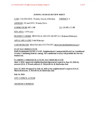
ZONING CHANGE REVIEW SHEET CASE: C14-2026-0014 - Wonsley Grocery & Kitchen DISTRICT: 4 ADDRESS: 301 and 309 E. Wonsley Drive ZONING FROM: MF-2-NP TO: LR-MU-CO-NP SITE AREA: 1.078 acres PROPERTY OWNER: NUSY REAL ESTATE GROUP LLC (Rahemtu Maknojia) APPLICANT/AGENT: Sohil Maknojia CASE MANAGER: Sherri Sirwaitis (512-974-3057, sherri.sirwaitis@austintexas.gov) STAFF RECOMMEDATION: Staff recommends LR-MU-CO-NP, Neighborhood Commercial-Mixed Use-Conditional Overlay Combining District, zoning. The conditional overlay will prohibit the Service Station use. PLANNING COMMISSION ACTION / RECOMMENDATION: June 9, 2026: Approved neighborhood postponement request to June 23, 2026 by consent (11-0, A. Woods-absent); F. Maxwell-1st, B. Bedrosian-2nd. June 23, 2026: Postponed to July 14, 2026 at the neighborhood's request (11-0, F. Maxwell-absent); A. Powell-1st, B. Bedrosian-2nd. July 14, 2026 CITY COUNCIL ACTION: ORDINANCE NUMBER: 11 C14-2026-0014 - Wonsley Grocery & Kitchen; District 41 of 15 C14-2026-0014 ISSUES: N/A CASE MANAGER COMMENTS: 2 The property in question is a 1.078 acre vacant lot that is located at the southeast corner of E. Wonsley Drive and Gessner Drive. The lots to the north, across E. Wonsley Drive, are developed with single-family residences zoned SF-3-NP. To the south there is a multifamily use along Gessner Drive and a restaurant and a cocktail lounge, fronting the Anderson Lane/U.S. Highway 183 Service Road West Bound zoned GR-NP and CS-1-CO-NP respectively. There are multifamily developments to the east and west zoned MF-3-NP. In this request, the applicant is asking for LR-MU-CO-NP zoning to develop a neighborhood market (please see Applicant’s Request Letter – Exhibit C). The site under consideration is located within the North Lamar Combined Neighborhood Planning (Georgian Acres) area. The Future Land Use Map designates this tract as Mixed Use. Therefore, a Neighborhood Plan Amendment is not required. The staff recommends Neighborhood Commercial-Mixed Use-Conditional Overlay - Neighborhood Plan Combining District zoning. The site under consideration meets the intent of the ‘LR’ base district as it will allow for limited office and commercial uses to provide services for the adjacent residential developments. The proposed zoning is compatible with the higher density residential and commercial zoning patterns to the south, east and west. The property fronts and takes access to a Wonsley Drive, a level 2/collector roadway, and it is located near a public transit stop on Georgian Drive to the west. The applicant agrees with the staff’s recommendation. BASIS OF RECOMMENDATION: 1. The proposed zoning should be consistent with the purpose statement of the district sought. Neighborhood Commercial district …
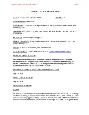
ZONING CHANGE REVIEW SHEET CASE: C14-2025-0003 – 6th and Walsh DISTRICT: 9 ZONING FROM: LI-PDA-NP ZONING TO: LI-PDA-NP; to change conditions of zoning to increase the maximum floor area ratio (FAR). ADDRESS: 1135, 1137, 1139, 1141, and 1143 W. 6th Street and 503, 505, 507, 509, & 511 Walsh Street SITE AREA: 1.195 acres (52,054 sq. ft.) PROPERTY OWNER: Walsh Street Ventures, LLC; Walsh Street Ventures 2, LLC; and Cohn Ventures, LLC AGENT: Manifold Development, LLC (Mila Santana) CASE MANAGER: Cynthia Hadri 512-974-7620, Cynthia.hadri@austintexas.gov STAFF RECOMMENDATION: The staff recommendation is to recommend limited industrial service - planned development area - neighborhood plan (LI-PDA-NP) combined district zoning, to amend Ordinance No. 20250724-173 to change conditions of zoning to increase the maximum floor area ratio (FAR) from 1:1 to 6.75:1. PLANNING COMMISSION ACTION / RECOMMENDATION: July 14, 2026: CITY COUNCIL ACTION: July 23, 2026: ORDINANCE NUMBER: ISSUES: On June 15, 2026, the applicant requested to amend Ordinance No. 20250724-173 to change conditions of zoning to increase the maximum floor area ratio (FAR) from 1:1 to 6.75:1. This case was previously approved at City Council on July 24, 2025, with additional conditions as listed in Council Member Qadri’s motion sheet. Please refer to Exhibit E (CM Qadri Motion 12 C14-2025-0003 - 6th and Walsh; District 91 of 23 C14-2025-0003 2 Sheet). The additional staff comments below are based on the original LIPDA-NP request from 2025. CASE MANAGER COMMENTS: The property in question is approximately 1.19 acres, is developed with multiple office buildings, and has access to both West 6th Street (level 3) and Walsh St (level 1). The site is currently zoned limited industrial service - planned development area - neighborhood plan (LI-PDA-NP) combining zoning district. This property is in the Old West Austin Neighborhood Plan and is characterized as a mixed use area just south of the Castle Hill Historic District. The property has several office and commercial uses, various restaurants, art galleries and cocktail lounges (CS-MU-V-CO-NP; CS-MU-CO-NP; CS-MU-CO-HD-NP; CS-H-NP; CS-1-CO-HD-NP; LI-PDA-NP; LI-CO-NP). Please refer to Exhibits A (Zoning Map) and B (Aerial View). The applicant is requesting limited industrial service - planned development area - neighborhood plan (LI-PDA-NP) combining district. The applicant has requested to amend Ordinance No. 20250724-173 to change conditions of zoning to increase the maximum floor area ratio (FAR) from 1:1 to 6.75:1. The FAR was listed as not applicable in the applicant’s original request which gave them …
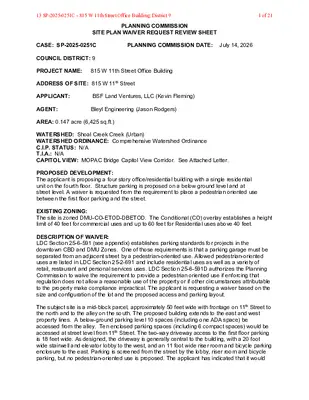
PLANNING COMMISSION SITE PLAN WAIVER REQUEST REVIEW SHEET CASE: SP-2025-0251C PLANNING COMMISSION DATE: July 14, 2026 COUNCIL DISTRICT: 9 PROJECT NAME: 815 W 11th Street Office Building ADDRESS OF SITE: 815 W 11th Street APPLICANT: BSF Land Ventures, LLC (Kevin Fleming) AGENT: Bleyl Engineering (Jason Rodgers) AREA: 0.147 acre (6,425 sq.ft.) WATERSHED: Shoal Creek Creek (Urban) WATERSHED ORDINANCE: Comprehensive Watershed Ordinance C.I.P. STATUS: N/A T.I.A.: N/A CAPITOL VIEW: MOPAC Bridge Capitol View Corridor. See Attached Letter. PROPOSED DEVELOPMENT: The applicant is proposing a four story office/residential building with a single residential unit on the fourth floor. Structure parking is proposed on a below ground level and at street level. A waiver is requested from the requirement to place a pedestrian oriented use between the first floor parking and the street. EXISTING ZONING: The site is zoned DMU-CO-ETOD-DBETOD. The Conditional (CO) overlay establishes a height limit of 40 feet for commercial uses and up to 60 feet for Residential uses above 40 feet. DESCRIPTION OF WAIVER: LDC Section 25-6-591 (see appendix) establishes parking standards for projects in the downtown CBD and DMU Zones. One of those requirements is that a parking garage must be separated from an adjacent street by a pedestrian-oriented use. Allowed pedestrian-oriented uses are listed in LDC Section 25-2-691 and include residential uses as well as a variety of retail, restaurant and personal services uses. LDC Section 25-6-591D authorizes the Planning Commission to waive the requirement to provide a pedestrian oriented use if enforcing that regulation does not allow a reasonable use of the property or if other circumstances attributable to the property make compliance impractical. The applicant is requesting a waiver based on the size and configuration of the lot and the proposed access and parking layout. The subject site is a mid-block parcel, approximately 50 feet wide with frontage on 11th Street to the north and to the alley on the south. The proposed building extends to the east and west property lines. A below-ground parking level 10 spaces (including one ADA space) be accessed from the alley. Ten enclosed parking spaces (including 6 compact spaces) would be accessed at street level from 11th Street. The two-way driveway access to the first floor parking is 18 feet wide. As designed, the driveway is generally central to the building, with a 20 foot wide stairwell and elevator lobby to the west, and an 11 foot wide riser …
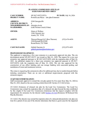
PLANNING COMMISSION SITE PLAN EXTENSION REVIEW SHEET CASE NUMBER: PROJECT NAME: SP-2017-0387C(XT3) Powell Lane Plaza – Dite plan Extension PC DATE: July 14, 2026 ADDRESS: COUNCIL DISTRICT: NEIGBORHOOD PLAN: Georgian Acres WATERSHED: 8240 Georgian Dr 4 Little Walnut Creek (Urban) OWNER: AGENT: Simon A Wallace 1194 Chestnut Ave Austin, TX 78702 Thrower Design LLC (Ron Thrower) 2880 Donnell Dr #2802 Round Rock, TX 78664 (512)-476-4456 CASE MANAGER: Gabriel Guerrero Jr. gabriel.guerrero@austintexas.gov (512) 978-4658 PROPOSED DEVELOPMENT: The applicant is requesting a five year extension to a previously approved site plan. The site development permit SP-2017-0387C was issued on May 01, 2019. The request for a one year extension was approved pursuant to SP-2017-0387C(XT) with the expiration date of May 01, 2023. An additional request for a three year extension was approved pursuant to SP-2017- 0387C(XT2) with the expiration date of May 01, 2026. The site was approved for the construction of one office building and one storage building with associated parking and installation of water and wastewater services. The owner is requesting this extension to allow for additional time due to market demands before initiating construction. There are no new or additional improvements proposed with this extension request. STAFF RECOMMENDATION: Staff recommends approval to extend this site plan permit by five years from May 01, 2026 to May 01, 2031, based on the case meeting criteria from LDC Section 25-5-62(C)(1)(a). 25-5-63(C) Extension of released site plan by the Land Use Commission: The Land Use Commission may extend the expiration date of a released site plan beyond the date established by this chapter if the Land Use Commission determines that the request complies with the requirements for extension by the director under Section 25-5-62 (Extension Of Released Site Plan By Director). 25-5-62(C) The director may extend the expiration date of a released administrative site plan one time for a period of one year if the director determines that there is good cause for the requested 14 SP-2017-0387C(XT3) - Powell Lane Plaza - Site Plan Extension; District 41 of 5 SP-2017-0387C(XT2) Powell Lane Plaza Site Plan Extension 2 extension; and (1) the director determines that: (a) the site plan substantially complies with the requirements that apply to a new application for site plan approval; (b) the applicant filed the original application for site plan approval with the good faith expectation that the site plan would be constructed; (c) the applicant constructed at least …
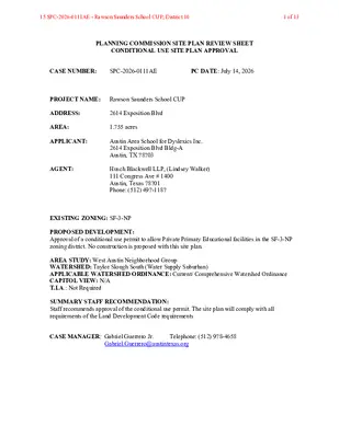
PLANNING COMMISSION SITE PLAN REVIEW SHEET CONDITIONAL USE SITE PLAN APPROVAL CASE NUMBER: SPC-2026-0111AE PC DATE: July 14, 2026 PROJECT NAME: Rawson Saunders School CUP ADDRESS: 2614 Exposition Blvd AREA: 1.755 acres APPLICANT: AGENT: Austin Area School for Dyslexics Inc. 2614 Exposition Blvd Bldg-A Austin, TX 78703 Husch Blackwell LLP, (Lindsey Walker) 111 Congress Ave # 1400 Austin, Texas 78701 Phone: (512) 497-1187 EXISTING ZONING: SF-3-NP PROPOSED DEVELOPMENT: Approval of a conditional use permit to allow Private Primary Educational facilities in the SF-3-NP zoning district. No construction is proposed with this site plan. AREA STUDY: West Austin Neighborhood Group WATERSHED: Taylor Slough South (Water Supply Suburban) APPLICABLE WATERSHED ORDINANCE: Current/ Comprehensive Watershed Ordinance CAPITOL VIEW: N/A T.I.A.: Not Required SUMMARY STAFF RECOMMENDATION: Staff recommends approval of the conditional use permit. The site plan will comply with all requirements of the Land Development Code requirements CASE MANAGER: Gabriel Guerrero Jr. Telephone: (512) 978-4658 Gabriel.Guerrero@austintexas.org 15 SPC-2026-0111AE - Rawson Saunders School CUP; District 101 of 13 SPC-2026-0111AE Rawson Saunders School CUP Page 2 PROJECT INFORMATION: ZONING: SF-3-NP MAX. BLDG. CVRG: 40% MAX. HEIGHT: 35 ft. MAX. IMP. CVRG: 45% EXIST. USE: Civic PROP. BLDG. CVRG: 19.8% PROP.HEIGHT: 25 ft. PROP. IMPERV. CVRG. 37.25% PROPOSED USE: Civic SUMMARY COMMENTS ON SITE PLAN: Land Use: The lot is zoned SF-3-NP (Family Residence, Neighborhood Plan). The submitted site plan is to allow the Private Primary Educational Facilities use. No construction is proposed. Environmental: The site is located in the Edward's Aquifer Recharge Zone. SURROUNDING CONDITIONS: Zoning/ Land use: North: PUD-NP; Residence East: SF-3-NP; Religious Assembly South: SF-3-NP; Single family Res West: PUD-NP; Residence Street Exposition Blvd R.O.W. 60’ Surfacing 40’ Classification Level 3 NEIGHBORHOOD ORGANIZATION: Austin Neighborhoods Council, Central West Austin Neighborhood Plan Contact Team, Friends of Austin Neighborhoods, Preservation Austin, Save Barton Creek Assn., West Austin Neighborhood Group CONDITIONAL USE PERMIT REVIEW AND EVALUATION CRITERA The following evaluation is included to provide staff position on each point of the conditional use permit criteria. Section 25-5-145 of the Land Development Code states: A. “The Land Use Commission shall determine whether the proposed development or use of a conditional use site plan complies with the requirements of this section.” B. A Conditional Use Site Plan Must: 1. Comply with the requirements of this title; Staff Response: This site plan complies with all regulations and requirements of the Land Development Code. 2. Comply with the objectives and …
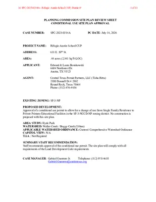
PLANNING COMMISSION SITE PLAN REVIEW SHEET CONDITIONAL USE SITE PLAN APPROVAL CASE NUMBER: SPC-2025-0314A PC DATE: July 14, 2026 PROJECT NAME: Rifugio Austin School CUP ADDRESS: 611 E. 50th St. AREA: .44 acres (2,541 Sq Ft LOC) APPLICANT: AGENT: Edward & Laura Bonskowski 6604 Northwest Dr. Austin, TX 78723 Central Texas Permit Partners, LLC (Tisha Ritta) 2880 Donnell Dr # 2802 Round Rock, Texas 78664 Phone: (512) 476-4456 EXISTING ZONING: SF-3-NP PROPOSED DEVELOPMENT: Approval of a conditional use permit to allow for a change of use from Single Family Residence to Private Primary Educational Facilities in the SF-3-NCCD-NP zoning district. No construction is proposed with this site plan. AREA STUDY: Hyde Park WATERSHED: Waller Creek / Boggy Creek (Urban) APPLICABLE WATERSHED ORDINANCE: Current/ Comprehensive Watershed Ordinance CAPITOL VIEW: N/A T.I.A.: Not Required SUMMARY STAFF RECOMMENDATION: Staff recommends approval of the conditional use permit. The site plan will comply with all requirements of the Land Development Code requirements CASE MANAGER: Gabriel Guerrero Jr. Telephone: (512) 978-4658 Gabriel.Guerrero@austintexas.org 16 SPC-2025-0314A - Rifugio Austin School CUP; District 91 of 11 SPC-2025-0314A Rifugio Austin School CUP Page 2 PROJECT INFORMATION: ZONING: SF-3-NCCD-NP ALLOWED FAR: .4:1 MAX. BLDG. CVRG: 40% MAX. HEIGHT: 35 ft. MAX. IMP. CVRG: 45% EXIST. USE: Civic PROP FAR: 0.16:1 PROP. BLDG. CVRG: 15.9% PROP.HEIGHT: 15 ft. PROP. IMPERV. CVRG. 54.5% PROPOSED USE: Civic SUMMARY COMMENTS ON SITE PLAN: Land Use: The lot is zoned SF-3-NCCD-NP (Family Residence Neighborhood Conservation- Neighborhood Plan). The submitted site plan is to allow for a change of use from Single Family Residence to Private Primary Educational Facilities use. No construction is proposed. Environmental: The site is not located in the Edward's Aquifer Recharge Zone. SURROUNDING CONDITIONS: Zoning/ Land use: North: SF-3-NCCD-NP ; Private Secondary Educational Facilities East: SF-3-NCCD-NP ; Single Family Res South: SF-3-NCCD-NP ; Single Family Res West: SF-3-NCCD-NP ; Single Family Res Street E. 50th St R.O.W. 55’ Surfacing 30’ Classification Level 1 NEIGHBORHOOD ORGANIZATION: Austin Neighborhoods Council, Friends of Austin Neighborhoods, Friends of Hyde Park, Homeless Neighborhood Association, Hyde Park Neighborhood Assn., Hyde Park Neighborhood Plan Contact Team, North Austin Neighborhood Alliance, Preservation Austin CONDITIONAL USE PERMIT REVIEW AND EVALUATION CRITERA The following evaluation is included to provide staff position on each point of the conditional use permit criteria. Section 25-5-145 of the Land Development Code states: A. “The Land Use Commission shall determine whether the proposed development or use of a …
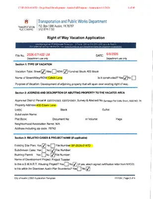
17 SP-2026-0147D - Dogs Head Development - Austin Full Purpose - Annexation 6/1/20261 of 49 17 SP-2026-0147D - Dogs Head Development - Austin Full Purpose - Annexation 6/1/20262 of 49 17 SP-2026-0147D - Dogs Head Development - Austin Full Purpose - Annexation 6/1/20263 of 49 17 SP-2026-0147D - Dogs Head Development - Austin Full Purpose - Annexation 6/1/20264 of 49 P.O. Box 1088 Austin, TX 78767 Right-of-Way Vacation Transmittal Letter LandManagementROW@AustinTexas.gov | Phone: 3-1-1 (or 512-974-2000 outside Austin) For submittal and fee information, see AustinTexas.gov/LDE Provide a reason for the vacation by answering the following questions: 1. 2. 3. Property Type: Residential � Commercial � How was the area to be vacated dedicated? Plat � Separate Instrument � Did the City purchase the area to be vacated? (i.e., by Street Deed) Yes � No � 4. Is both the area to be vacated and your property in the same “subdivision”? (They must both be in the same subdivision to be eligible.) Yes � No � 5. 6. Is the area to be vacated a: Functional right-of-way � Only dedicated on paper � Are there any utility lines within the area to be vacated? Yes � No � If yes, what are your plans for the utilities? __________________________________________ _____________________________________________________________________________ Applicants should be advised that easements will be retained to protect existing utilities, even if utility relocation is proposed. Also, be advised that no structures may be built on, over or under the easements without a license agreement, insurance, and an annual fee. 7. How do you plan to develop the area to be vacated? __________________________________ _____________________________________________________________________________ 8. 9. 10. 11. 12. Has a site plan been submitted for your project? Yes � No � Is your project a Unified Development? Yes � No � Is your project a S.M.A.R.T. Housing Project? Yes � No � When do you anticipate starting construction of the development? ______________________ What is the current zoning on the adjacent properties? ________________________________ 17 SP-2026-0147D - Dogs Head Development - Austin Full Purpose - Annexation 6/1/20265 of 49 13. 14. 15. What is the current status of the adjacent properties? _________________________________ What type of parking facilities currently exist? _______________________________________ Will your parking requirements increase with the expansion? Yes � No � 16. How will the increase be handled? ________________________________________________ _____________________________________________________________________________ _____________________________________________________________________________ _____________________________________________________________________________ _____________________________________________________________________________ 17. Have any agreements or easements been executed with adjacent landowner(s) or in draft form? Yes …
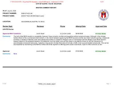
CITY OF AUSTIN - R.O.W. VACATION MASTER COMMENT REPORT As of: July 02, 2026 PROJECT NUMBER: 2026-071422 LM PROJECT NAME: 2026-071422 LM (405 Edwin Lane) LOCATION: 405 EDWIN LN, AUSTIN, TX 78742 Review Dept. LM ATD Review Reviewer Phone Attempt Date Approved Date Approved With Conditions Justin Good 512-974-1449 06/09/2026 07/02/2026 Comments: The bulk of the ROW vacation is acceptable, however I have concerns at either end regarding vehicle turnaround space. Although in the ultimate buildout there will be a connected street network, in the interim between approving the ROW vacation and the new street network opening, a dead-end condition is created on Ramirez Lane and a dead-end condition is created on Hergotz Lane (in combination with the Hergotz Lane ROW vacation request) based on the proposed requests. Consideration must be made to ensure that space is provided for drivers to use the intersection to accommodate turnaround maneuvers. Typically a long section of street that ends will include a traffic circle to accommodate turnarounds. This can be accomplished by maintaining some ROW at either end of the segment or offering public access easements. Open to other solutions as well. Approved Comments: None Justin Good 512-974-1449 07/02/2026 07/02/2026 7/2/26 73002_f_lm_master_report Page 1 17 SP-2026-0147D - Dogs Head Development - Austin Full Purpose - Annexation 6/1/20261 of 9 As of: July 02, 2026 PROJECT NUMBER: 2026-071422 LM PROJECT NAME: 2026-071422 LM (405 Edwin Lane) LOCATION: 405 EDWIN LN, AUSTIN, TX 78742 Review Dept. Reviewer Phone Attempt Date Approved Date LM Austin Resource Recovery Review Approved Michael Zavala (512) 974-1837 06/08/2026 06/08/2026 Comments: No issues with this vacation that would affect ARR services. 7/2/26 73002_f_lm_master_report Page 2 17 SP-2026-0147D - Dogs Head Development - Austin Full Purpose - Annexation 6/1/20262 of 9 As of: July 02, 2026 PROJECT NUMBER: 2026-071422 LM PROJECT NAME: 2026-071422 LM (405 Edwin Lane) LOCATION: 405 EDWIN LN, AUSTIN, TX 78742 Review Dept. Reviewer Phone Attempt Date Approved Date LM AW Infrastructure Management Approved With Conditions Eric Sermeno 512-972-0497 06/10/2026 07/02/2026 Comments: Austin Water (AW) has no objections to the request ROW Vacation but note new water, wastewater, and or reclaimed water line easements will need to be dedicated for improvements required by UIRs 6416, 6417 & 6418. Approved Eric Sermeno 512-972-0497 07/02/2026 07/02/2026 Comments: Austin Water (AW) approves the ROW vacation request. Approved Eric Sermeno 512-972-0497 06/09/2026 07/02/2026 Comments: AW has no infra in those areas ¿ clear …
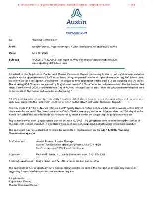
To: From: Date: Subject: MEMORANDUM Planning Commission Joseph Fotinos, Project Manager, Austin Transportation and Public Works June 16, 2026 F# 2026-071422 LM Street Right-of-Way Vacation of approximately 5.3307 acres abutting 405 Edwin Lane Attached is the Application Packet and Master Comment Report pertaining to the street right-of-way vacation application for approximately 5.3307 acres land, being the paved/developed right-of-way abutting 405 Edwin Lane, as shown on the Santiago Del Valle Grant. The proposed vacation tract will be added to the abutting 954.06 acres. The abutting 954.06 acres are owned by Dog’s Head Land JV, LTD, a Texas limited partnership. Per the transmittal letter dated June 4, 2026, received by the City of Austin, the applicant states, “How do you plan to develop the area to be vacated? Response: Advanced manufacturing.” All affected departments and private utility franchise stakeholders have reviewed the application and recommend approval, subject to the reviewers’ conditions shown on the attached Master Comment Report. Per City Code §14-11-71 – Notice to Interested Property Owners Public notice will be sent to owners within 300’ of the area to be vacated. The director of Austin Public Works may approve the application after the 10th day that the notice is issued; and an affected property owner may submit comments regarding the proposed vacation. Public Notice was sent to appropriate parties on June 10, 2026. No objections have been received by staff as of the date of this memorandum. If objections were sent and not cleared add objection(s) to this memorandum. The applicant has requested that this item be submitted for placement on the July 14, 2026, Planning Commission agenda. Staff contact: Joseph Fotinos, Project Manager Austin Transportation and Public Works, 512-978-4659 landmanagementROW@austintexas.gov Applicant: Richard T. Suttle, Jr., rsuttle@abaustin.com, 512-435-2368 Abutting Landowner: Dog’s Head Land JV, LTD, a Texas limited partnership The applicant and/or property owner’s representative will be present at the meeting to answer any questions regarding future development and the vacation request. Attachments: Application Packet Master Comment Report 17 SP-2026-0147D - Dogs Head Development - Austin Full Purpose - Annexation 6/1/20261 of 1
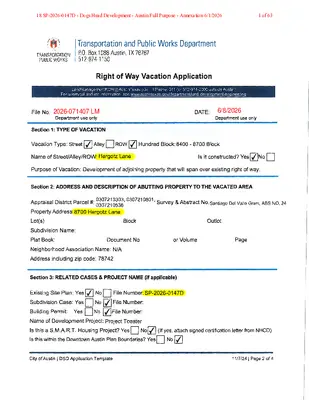
18 SP-2026-0147D - Dogs Head Development - Austin Full Purpose - Annexation 6/1/20261 of 63 18 SP-2026-0147D - Dogs Head Development - Austin Full Purpose - Annexation 6/1/20262 of 63 18 SP-2026-0147D - Dogs Head Development - Austin Full Purpose - Annexation 6/1/20263 of 63 18 SP-2026-0147D - Dogs Head Development - Austin Full Purpose - Annexation 6/1/20264 of 63 P.O. Box 1088 Austin, TX 78767 Right-of-Way Vacation Transmittal Letter LandManagementROW@AustinTexas.gov | Phone: 3-1-1 (or 512-974-2000 outside Austin) For submittal and fee information, see AustinTexas.gov/LDE Provide a reason for the vacation by answering the following questions: 1. 2. 3. Property Type: Residential � Commercial � How was the area to be vacated dedicated? Plat � Separate Instrument � Did the City purchase the area to be vacated? (i.e., by Street Deed) Yes � No � 4. Is both the area to be vacated and your property in the same “subdivision”? (They must both be in the same subdivision to be eligible.) Yes � No � 5. 6. Is the area to be vacated a: Functional right-of-way � Only dedicated on paper � Are there any utility lines within the area to be vacated? Yes � No � If yes, what are your plans for the utilities? __________________________________________ _____________________________________________________________________________ Applicants should be advised that easements will be retained to protect existing utilities, even if utility relocation is proposed. Also, be advised that no structures may be built on, over or under the easements without a license agreement, insurance, and an annual fee. 7. How do you plan to develop the area to be vacated? __________________________________ _____________________________________________________________________________ 8. 9. 10. 11. 12. Has a site plan been submitted for your project? Yes � No � Is your project a Unified Development? Yes � No � Is your project a S.M.A.R.T. Housing Project? Yes � No � When do you anticipate starting construction of the development? ______________________ What is the current zoning on the adjacent properties? ________________________________ 18 SP-2026-0147D - Dogs Head Development - Austin Full Purpose - Annexation 6/1/20265 of 63 13. 14. 15. What is the current status of the adjacent properties? _________________________________ What type of parking facilities currently exist? _______________________________________ Will your parking requirements increase with the expansion? Yes � No � 16. How will the increase be handled? ________________________________________________ _____________________________________________________________________________ _____________________________________________________________________________ _____________________________________________________________________________ _____________________________________________________________________________ 17. Have any agreements or easements been executed with adjacent landowner(s) or in draft form? Yes …
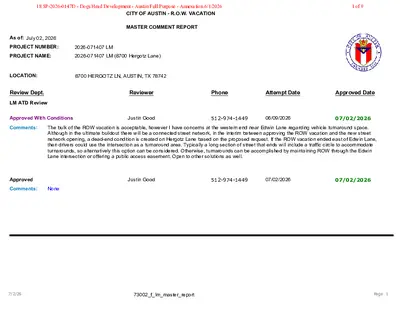
CITY OF AUSTIN - R.O.W. VACATION MASTER COMMENT REPORT As of: July 02, 2026 PROJECT NUMBER: 2026-071407 LM PROJECT NAME: 2026-071407 LM (8700 Hergotz Lane) LOCATION: 8700 HERGOTZ LN, AUSTIN, TX 78742 Review Dept. LM ATD Review Reviewer Phone Attempt Date Approved Date Approved With Conditions Justin Good 512-974-1449 06/09/2026 07/02/2026 Comments: The bulk of the ROW vacation is acceptable, however I have concerns at the western end near Edwin Lane regarding vehicle turnaround space. Although in the ultimate buildout there will be a connected street network, in the interim between approving the ROW vacation and the new street network opening, a dead-end condition is created on Hergotz Lane based on the proposed request. If the ROW vacation ended east of Edwin Lane, then drivers could use the intersection as a turnaround area. Typically a long section of street that ends will include a traffic circle to accommodate turnarounds, so alternatively this option can be considered. Otherwise, turnarounds can be accomplished by maintaining ROW through the Edwin Lane intersection or offering a public access easement. Open to other solutions as well. Approved Comments: None Justin Good 512-974-1449 07/02/2026 07/02/2026 7/2/26 73002_f_lm_master_report Page 1 18 SP-2026-0147D - Dogs Head Development - Austin Full Purpose - Annexation 6/1/20261 of 9 As of: July 02, 2026 PROJECT NUMBER: 2026-071407 LM PROJECT NAME: 2026-071407 LM (8700 Hergotz Lane) LOCATION: 8700 HERGOTZ LN, AUSTIN, TX 78742 Review Dept. Reviewer Phone Attempt Date Approved Date LM Austin Resource Recovery Review Approved Michael Zavala (512) 974-1837 06/08/2026 06/08/2026 Comments: No issues with this vacation that would affect ARR services. 7/2/26 73002_f_lm_master_report Page 2 18 SP-2026-0147D - Dogs Head Development - Austin Full Purpose - Annexation 6/1/20262 of 9 As of: July 02, 2026 PROJECT NUMBER: 2026-071407 LM PROJECT NAME: 2026-071407 LM (8700 Hergotz Lane) LOCATION: 8700 HERGOTZ LN, AUSTIN, TX 78742 Review Dept. Reviewer Phone Attempt Date Approved Date LM AW Infrastructure Management Rejected Comments: Austin Water (AW) does not recommend the requested ROW vacation at this time. AW needs to retain easement rights of sufficient width if the right of way is vacated. Additionally, new AW easements will need to be dedicated to cover the improvements required by UIRs 6416, 6417 & 6418. Eric Sermeno 512-972-0497 06/10/2026 Approved With Conditions Eric Sermeno 512-972-0497 06/11/2026 07/02/2026 Comments: In exchange for the requested 2.9026 acres (126,437 square feet) partial vacation of Hergotz Lane, Austin Water (AW) must retain …
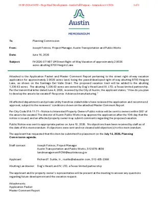
To: From: Date: Subject: MEMORANDUM Planning Commission Joseph Fotinos, Project Manager, Austin Transportation and Public Works June 16, 2026 F# 2026-071407 LM Street Right-of-Way Vacation of approximately 2.9026 acres abutting 8700 Hergotz Lane Attached is the Application Packet and Master Comment Report pertaining to the street right-of-way vacation application for approximately 2.9026 acres land, being the paved/developed right-of-way abutting 8700 Hergotz Lane, as shown on the Santiago Del Valle Grant. The proposed vacation tract will be added to the abutting 1,336.63 acres. The abutting 1,336.63 acres are owned by Dog’s Head Land JV, LTD, a Texas limited partnership. Per the transmittal letter dated June 4, 2026, received by the City of Austin, the applicant states, “How do you plan to develop the area to be vacated? Response: Advanced manufacturing.” All affected departments and private utility franchise stakeholders have reviewed the application and recommend approval, subject to the reviewers’ conditions shown on the attached Master Comment Report. Per City Code §14-11-71 – Notice to Interested Property Owners Public notice will be sent to owners within 300’ of the area to be vacated. The director of Austin Public Works may approve the application after the 10th day that the notice is issued; and an affected property owner may submit comments regarding the proposed vacation. Public Notice was sent to appropriate parties on June 10, 2026. No objections have been received by staff as of the date of this memorandum. If objections were sent and not cleared add objection(s) to this memorandum. The applicant has requested that this item be submitted for placement on the July 14, 2026, Planning Commission agenda. Staff contact: Joseph Fotinos, Project Manager Austin Transportation and Public Works, 512-978-4659 landmanagementROW@austintexas.gov Applicant: Richard T. Suttle, Jr., rsuttle@abaustin.com, 512-435-2368 Abutting Landowner: Dog’s Head Land JV, LTD, a Texas limited partnership The applicant and/or property owner’s representative will be present at the meeting to answer any questions regarding future development and the vacation request. Attachments: Application Packet Master Comment Report 18 SP-2026-0147D - Dogs Head Development - Austin Full Purpose - Annexation 6/1/20261 of 1
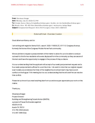
From: Shoshana Krieger Sent: Monday, July 13, 2026 4:52 PM To: Estrada, Nancy <Nancy.Estrada@austintexas.gov>; Harden, Joi <Joi.Harden@austintexas.gov> Cc: Woods, Alice - BC <BC-Alice.Woods@austintexas.gov>; mariocantu; Aabiya Baqai Subject: Postponement Request: Items 8 & 9 Congress Views 2025-116856 ZC External Email - Exercise Caution Good afternoon Nancy and Joi: I am writing with regard to Items 8 & 9, case # 2025-116856 ZC, 6111 S. Congress Avenue, formerly the home of the Congress Mobile Home Park community. We would like to request a postponement of the matter to allow for us to be able to conduct outreach to the former residents who were displaced from the community so they are aware of the item and have the opportunity to engage in the process if they so desire. It is our understanding that the applicant will accept a four week postponement request and a four week postponement suffices for us at this time. I do want to note that our original request was 6 weeks as we believe the Chair of the neighborhood contact team may have a work conflict on the August 11th meeting but it is our understanding that he will see if he can resolve that conflict. Please let us know if you need anything else from us and we super appreciate your work on this matter. Thank you, Shoshana Krieger Project Director Building and Strengthening Tenant Action (BASTA) a project of Texas RioGrande Legal Aid 4920 N IH 35 Austin TX 78751 512.782.0354 (direct) 512.447.3940 (fax) 08 NPA-2025-0020.04 - Congress Views; District 21 of 1
From: Shoshana Krieger Sent: Monday, July 13, 2026 4:52 PM To: Estrada, Nancy <Nancy.Estrada@austintexas.gov>; Harden, Joi <Joi.Harden@austintexas.gov> Cc: Woods, Alice - BC <BC-Alice.Woods@austintexas.gov>; mariocantu; Aabiya Baqai Subject: Postponement Request: Items 8 & 9 Congress Views 2025-116856 ZC External Email - Exercise Caution Good afternoon Nancy and Joi: I am writing with regard to Items 8 & 9, case # 2025-116856 ZC, 6111 S. Congress Avenue, formerly the home of the Congress Mobile Home Park community. We would like to request a postponement of the matter to allow for us to be able to conduct outreach to the former residents who were displaced from the community so they are aware of the item and have the opportunity to engage in the process if they so desire. It is our understanding that the applicant will accept a four week postponement request and a four week postponement suffices for us at this time. I do want to note that our original request was 6 weeks as we believe the Chair of the neighborhood contact team may have a work conflict on the August 11th meeting but it is our understanding that he will see if he can resolve that conflict. Please let us know if you need anything else from us and we super appreciate your work on this matter. Thank you, Shoshana Krieger Project Director Building and Strengthening Tenant Action (BASTA) a project of Texas RioGrande Legal Aid 4920 N IH 35 Austin TX 78751 512.782.0354 (direct) 512.447.3940 (fax) 09 C14-2025-0096 - Congress Views; District 21 of 1
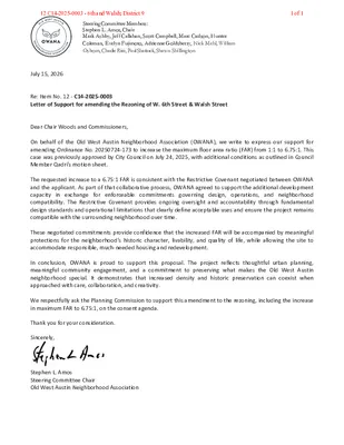
Steering Committee Members: Stephen L. Amos, Chair Mark Ashby, Jeff Callahan, Scott Campbell, Marc Carlson, Hunter Coleman, Evelyn Fujimoto, Adrienne Goldsberry, Nick Mehl, William Osborn, Charlie Rice, Paul Shattuck, Shawn Shillington July 15, 2026 Re: Item No. 12 - C14-2025-0003 Letter of Support for amending the Rezoning of W. 6th Street & Walsh Street Dear Chair Woods and Commissioners, On behalf of the Old West Austin Neighborhood Association (OWANA), we write to express our support for amending Ordinance No. 20250724-173 to increase the maximum floor area ratio (FAR) from 1:1 to 6.75:1. This case was previously approved by City Council on July 24, 2025, with additional conditions as outlined in Council Member Qadri's motion sheet. The requested increase to a 6.75:1 FAR is consistent with the Restrictive Covenant negotiated between OWANA and the applicant. As part of that collaborative process, OWANA agreed to support the additional development capacity in exchange for enforceable commitments governing design, operations, and neighborhood compatibility. The Restrictive Covenant provides ongoing oversight and accountability through fundamental design standards and operational limitations that clearly define acceptable uses and ensure the project remains compatible with the surrounding neighborhood over time. These negotiated commitments provide confidence that the increased FAR will be accompanied by meaningful protections for the neighborhood's historic character, livability, and quality of life, while allowing the site to accommodate responsible, much-needed housing and redevelopment. In conclusion, OWANA is proud to support this proposal. The project reflects thoughtful urban planning, meaningful community engagement, and a commitment to preserving what makes the Old West Austin neighborhood special. It demonstrates that increased density and historic preservation can coexist when approached with care, collaboration, and creativity. We respectfully ask the Planning Commission to support this amendment to the rezoning, including the increase in maximum FAR to 6.75:1, on the consent agenda. Thank you for your consideration. Sincerely, Stephen L. Amos Steering Committee Chair Old West Austin Neighborhood Association 12 C14-2025-0003 - 6th and Walsh; District 91 of 1
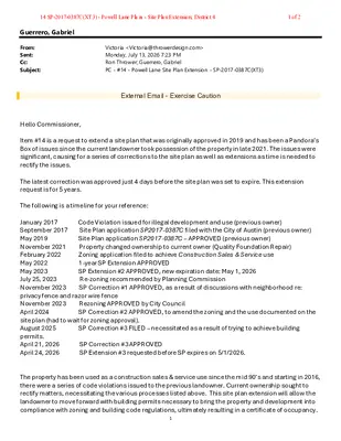
Guerrero, Gabriel From: Sent: Cc: Subject: Hello Commissioner, Victoria <Victoria@throwerdesign.com> Monday, July 13, 2026 7:23 PM Ron Thrower; Guerrero, Gabriel PC - #14 - Powell Lane Site Plan Extension - SP-2017-0387C(XT3) External Email - Exercise Caution Item #14 is a request to extend a site plan that was originally approved in 2019 and has been a Pandora’s Box of issues since the current landowner took possession of the property in late 2021. The issues were significant, causing for a series of corrections to the site plan as well as extensions as time is needed to rectify the issues. The latest correction was approved just 4 days before the site plan was set to expire. This extension request is for 5 years. The following is a timeline for your reference: Code Violation issued for illegal development and use (previous owner) Site Plan application SP2017-0387C filed with the City of Austin (previous owner) Site Plan application SP2017-0387C – APPROVED (previous owner) Property changed ownership to current owner (Quality Foundation Repair) Zoning application filed to achieve Construction Sales & Service use SP Extension #2 APPROVED, new expiration date: May 1, 2026 Re-zoning recommended by Planning Commission SP Correction #1 APPROVED, as a result of discussions with neighborhood re: January 2017 September 2017 May 2019 November 2021 February 2022 May 2022 1-year SP Extension APPROVED May 2023 July 25, 2023 November 2023 privacy fence and razor wire fence November 2023 April 2024 site plan (had to wait for zoning approval). August 2025 permits. April 21, 2026 April 24, 2026 Rezoning APPROVED by City Council SP Correction #2 APPROVED, to amend the zoning and the use documented on the SP Correction #3 FILED – necessitated as a result of trying to achieve building SP Correction #3 APPROVED SP Extension #3 requested before SP expires on 5/1/2026. The property has been used as a construction sales & service use since the mid 90’s and starting in 2016, there were a series of code violations issued to the previous landowner. Current ownership sought to rectify matters, necessitating the various processes listed above. This site plan extension will allow the landowner to move forward with building permits necessary to bring the property and development into compliance with zoning and building code regulations, ultimately resulting in a certificate of occupancy. 1 14 SP-2017-0387C(XT3) - Powell Lane Plaza - Site Plan Extension; District 41 of 2 Should you have questions …
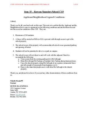
Item 15 – Rawson Saunders School CUP Applicant/Neighborhood Agreed Conditions Gabriel, Thank you for all your hard work on this case. This note is to confirm that the Applicant and the Neighborhood have come to agreement on the following conditions and ask that these be read into the record as conditions of the CUP. They are: 1. Maximum of 200 students 2. A fence will be erected on Hillview Rd. to prevent walk-through access to get to the school property 3. The school/owner of the property will accommodate all school/owner generated parking and queuing off-street 4. Students will not be permitted to drive to or park on campus. 5. The school/owner will not object to and will work with the adjacent Church to accomplish the following: a. Close access from the existing parking lot to McCullough. b. Make McCullough No Parking or Resident-Only Parking during business hours. c. Fence the church property along McCullough at our expense (ornamental fence just tall enough to keep people from hopping over it) d. Remove the stairs that people use to walk from McCullough to the church property. Thank you, and please let us know if you need any other documentation of these conditions from us. Nikelle Meade Partner HUSCH BLACKWELL 111 Congress Avenue Suite 1400 Austin, TX 78701-4093 Direct: 512-479-1147 Mobile: 512-992-6001 15 SPC-2026-0111AE - Rawson Saunders School CUP; District 101 of 18 CIVIL ENGINEER MILIAN CONSULTING LLC ALEJANDRA FLORES S., P.E. 501 N IH 35 #209C AUSTIN TEXAS 78702 830.513.9451 OWNER AUSTIN AREA SCHOOL FOR DYSLEXICS INC. 2614 EXPOSITION BLVD: ATTN: LAURA STEINBACH AUSTIN, TX 78703 SITE PLAN DEVELOPMENT NOTES 1. 2. 3. 4. 5. 6. 7. 8. 9. 10. 11. 12. NO PORTION OF THIS SITE IS LOCATED WITHIN THE 100-YEAR FLOODPLAIN, FIRM PANEL FM 48453C0445K. TRAVIS COUNTY, TEXAS DATED JANUARY 22, 2020. THIS PROJECT IS LOCATED IN THE TAYLOR SLOUGH SOUTH WATERSHED, WHICH IS CLASSIFIED AS A WATER SUPPLY SUBURBAN WATERSHED. THIS PROJECT IS LOCATED WITHIN THE EDWARDS AQUIFER RECHARGE ZONE PER TCEQ QUADRANGLE MAP. NEIGHBORHOOD PLAN: WEST AUSTIN NEIGHBORHOOD GROUP PROPERTY ZONING: SF-3-NP PROPOSED LAND USE: PRIVATE PRIMARY AND SECONDARY EDUCATIONAL FACILITIES GROSS ACREAGE: 1.755 ACRES LIMITS OF CONSTRUCTION: N/A COMPLIANCE WITH THE COMMERCIAL AND MULTI-FAMILY RECYCLING ORDNANCE IS MANDATORY FOR MULTI-FAMILY COMPLEXES, BUSINESS AND OFFICE BUILDINGS. THIS SITE PLAN IS SUBJECT TO SUBCHAPTER E OF THE LAND DEVELOPMENT CODE (COMMERCIAL DESIGN STANDARDS). NO CONSTRUCTION IS AUTHORIZED WITH THIS …
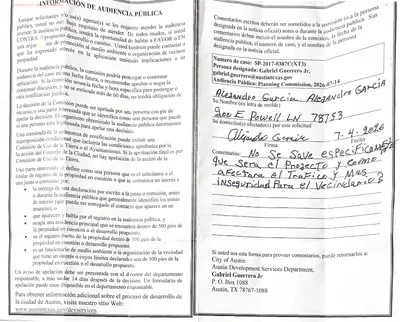
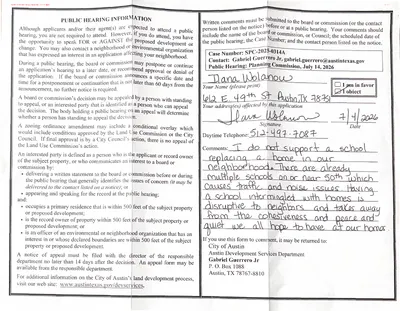
16 SPC-2025-0314A - Rifugio Austin School CUP; District 91 of 2 Guerrero, Gabriel From: Sent: To: Subject: Gayle Truax <gayle.truax@gmail.com> Tuesday, July 14, 2026 12:56 PM Guerrero, Gabriel Case SPC-2025-0314A You don't often get email from gayle.truax@gmail.com. Learn why this is important External Email - Exercise Caution Hello Gabriel, I am attaching the form with my objection. My handwriting is terrible! Below is what I wrote if you want to cut and paste it to your document Concerns 1. With. A large school across the street, we are decreasing the residential charm of our street 2. No stated/proposed number of students-could be 50 even if proposing 10 at this time. Case in point: expansion of Griffin School across the street has increased noise, activity and parking in our neighborhood 3. How is noise level measure to be considered a disturbance 4. I request a delay in approval. My neighbors are not aware of above factors (number of students, allowable noise level) 5. There was a wrong email given on the 11 page documents “Planning commission site plan review sheet”. My email was not delivered. Other emails may have gone unanswered. Again, please delay Thanks for your help, Gabriel 1 16 SPC-2025-0314A - Rifugio Austin School CUP; District 92 of 2
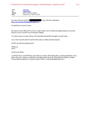
From: To: Subject: Date: David Tuffly LandUseLiaison REJECT Dogs Head proposal Monday, July 13, 2026 8:36:30 PM [You don't often get email from https://aka.ms/LearnAboutSenderIdentification ] . Learn why this is important at External Email - Exercise Caution My name is David Tuffly and I’m a Travis County resident. I don’t want this Dog head proposal to go forward because it wasn’t reviewed by environmental committee. Tirz means most tax revenue will stay in the Dogs head area but NOT enough for city and county. Also, I don’t want this land to be used for data centers or military tech development. Do NOT pass the Dogs Head proposal! Thank you, David Sent from my iPhone CAUTION: This is an EXTERNAL email. Please use caution when clicking links or opening attachments. If you believe this to be a malicious or phishing email, please report it using the "Report Message" button in Outlook. For any additional questions or concerns, contact CSIRT at "cybersecurity@austintexas.gov". 17 SP-2026-0147D - Dogs Head Development - Austin Full Purpose - Annexation 6/1/20261 of 1
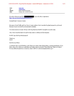
From: To: Subject: Date: David Tuffly LandUseLiaison REJECT Dogs Head proposal Monday, July 13, 2026 8:36:30 PM [You don't often get email from https://aka.ms/LearnAboutSenderIdentification ] . Learn why this is important at External Email - Exercise Caution My name is David Tuffly and I’m a Travis County resident. I don’t want this Dog head proposal to go forward because it wasn’t reviewed by environmental committee. Tirz means most tax revenue will stay in the Dogs head area but NOT enough for city and county. Also, I don’t want this land to be used for data centers or military tech development. Do NOT pass the Dogs Head proposal! Thank you, David Sent from my iPhone CAUTION: This is an EXTERNAL email. Please use caution when clicking links or opening attachments. If you believe this to be a malicious or phishing email, please report it using the "Report Message" button in Outlook. For any additional questions or concerns, contact CSIRT at "cybersecurity@austintexas.gov". 18 SP-2026-0147D - Dogs Head Development - Austin Full Purpose - Annexation 6/1/20261 of 1
REGULAR MEETING OF THE PLANNING COMMISSION TUESDAY, JUNE 23, 2026, AT 6 P.M. AUSTIN CITY HALL, COUNCIL CHAMBERS, ROOM 1001 301 WEST 2ND STREET AUSTIN, TEXAS Some members of the Planning Commission may be participating by videoconference. The meeting may be viewed online at: http://www.austintexas.gov/page/watch-atxn-live Public comment will be allowed in-person or remotely via telephone. Speakers may only register to speak on an item once either in-person or remotely and will be allowed up to three minutes to provide their comments. Registration no later than 2 p.m. on the day of the meeting is required for remote participation by telephone. To register to speak remotely, please use the QR code or link at the end of this document. If you have questions regarding speaker registration, please contact Ella Garcia, Staff Liaison, at LandUseLiaison@austintexas.gov or by phone at 512-978-0821. CURRENT COMMISSIONERS: Alice Woods, Chair (District 2) Casey Haney, Vice Chair (Mayor’s Representative) Felicity Maxwell, Secretary (District 5) Imad Ahmed, Parliamentarian (District 6) Anna Lan (Mayor’s Representative) Vacant (Mayor’s Representative) Chris Gannon (District 1) EX-OFFICIO MEMBERS: Nadia Barrera-Ramirez (District 3) Brian Bedrosian (District 4) Adam Powell (District 7) Peter Breton (District 8) Danielle Skidmore (District 9) Joshua Hiller (District 10) Jeffery Bowen, Chair of Board of Adjustment TC Broadnax, City Manager Candace Hunter, A.I.S.D. Board of Trustees Richard Mendoza, Director of Transportation and Public Works Staff Liaison: Ella Garcia, 512-978-0821 Attorney: AJ Urteaga, 512-974-2386 Page 1 of 6 AGENDA CALL TO ORDER PUBLIC COMMUNICATION: GENERAL The first four speakers signed up prior to the meeting being called to order will each be allowed a three-minute allotment to address their concerns regarding items not posted on the agenda. APPROVAL OF MINUTES 1. Approve the minutes of the Planning Commission regular meeting on Tuesday, June 9, 2026. PUBLIC HEARINGS 2. Plan Amendment: NPA-2023-0014.04 - 4302 Nuckols Crossing; District 2 Location: 4302, 4304 ½, and 4316 Nuckols Crossing Road, Williamson Creek Watershed; Southeast Combined (Franklin Park) Neighborhood Planning Area Owner/Applicant: Katherine Barnidge Agent: Request: Staff Rec.: Staff: LOC Consultants Civil Division (Sergio Lozano-Sanchez, P.E.) Single Family to Multifamily Residential land use Recommended Maureen Meredith, 512-974-2695, maureen.meredith@austintexas.gov Austin Planning 3. Rezoning: Location: C14-2025-0065 - 4302 Nuckols Crossing; District 2 4302, 4304 ½, and 4316 Nuckols Crossing Road, Williamson Creek Watershed; Southeast Combined (Franklin Park) Neighborhood Planning Area Owner/Applicant: Katherine Barnidge Agent: Request: Staff Rec.: Staff: LOC Consultants Civil Division (Sergio Lozano-Sanchez, P.E.) SF-2-CO-NP to MF-3-NP Staff …
SPEAKER REGISTRATION All participants wishing to address the commission must register to speak. Public participation is available by teleconference or in-person. Presentations and handouts are requested to be e- mailed by 1:00 p.m. on the day of the meeting. TELECONFERNCE REGISTRATION Registration for participation by teleconference closes at 2:00 p.m., the day of the meeting. Teleconference code and additional information to be provided after the closing of the teleconference registration period. IN-PERSON REGISTRATION While in-person registrants are encouraged to register in advance of the meeting, in-person registration closes at 5:30 p.m., the day of the meeting. Please scan the QR code below with a mobile device or click on the link below. Mobile devices will also be available at the meeting for public use for the purpose of speaker registration. SPEAKER DONATION OF TIME For discussion cases, speaker donation of time is an available option for in-person participants. Both the registered speaker donating time and the speaker recipient must be present when the public hearing is conducted. See chart below regarding speaker time allotments. SPEAKING ORDER The speaking order is determined by the order in which individuals register to speak and is conducted on a first-come, first-served basis. If multiple speakers register as the Primary Speaker, the first to register is allotted the additional speaking time. Participants who are part of a group or organization and wish to request a specific speaking order must contact Ella Garcia, Staff Liaison, at LandUseLiaison@austintexas.gov or 512-978-0821 as soon as possible, and no later than 2:00 p.m. on the day of the meeting. Click on the link below or scan the QR code and submit the form to register to speak. Speakers should submit a separate registration form for each item of interest. https://forms.office.com/g/W9r6dSSkUG SPEAKER TESTIMONY TIME ALLOCATION PUBLIC HEARING CASES – CONSENT ITEMS *Donation of time is not an option for consent items. All speakers in favor or opposed 2 minutes each PUBLIC HEARING CASES – DISCUSSION ITEMS The applicant/speaker designated by the applicant or the primary speaker in favor Primary speaker opposed All other speakers in favor or opposed 5 minutes; up to 9 minutes total with donated time, plus a 2 minute rebuttal 5 minutes; up to 9 minutes total with donated time 2 minutes each; up to 6 minutes total with donated time DISCUSSION POSTPONEMENT *Donation of time is not an option for discussion postponement. The applicant/speaker designated by the …
PLANNING COMMISSION MEETING MINUTES Tuesday, June 9, 2026 PLANNING COMMISSION MEETING MINUTES REGULAR MEETING TUESDAY, JUNE 9, 2026 The Planning Commission convened in a regular on Tuesday, May 26th, 2026, at Austin City Hall, Boards and Commissions, Room 1101, 301 W. Second Street, in Austin, Texas. Vice Chair Haney called the Planning Commission Meeting to order at 6:01 p.m. Commissioners in Attendance: Casey Haney Felicity Maxwell Imad Ahmed Peter Breton Brian Bedrosian Chris Gannon Danielle Skidmore Commissioners in Attendance Remotely: Adam Powell Nadia Barrera-Ramirez Joshua Hiller Anna Lan Commissioners Absent: Alice Woods Ex-Officio Members Absent: Jeffery Bowen TC Broadnax Candace Hunter Richard Mendoza 1 Vacancy on the Dais 1 PLANNING COMMISSION MEETING MINUTES Tuesday, June 9, 2026 PUBLIC COMMUNICATION: GENERAL None present. APPROVAL OF MINUTES 1. Approve the minutes of the Planning Commission regular meetings on Tuesday, April 28, 2026, Tuesday, May 12, 2026, and Tuesday, May 26, 2026. The minutes from the meeting of Tuesday, April 28, 2026, Tuesday, May 12, 2026, and Tuesday, May 26, 2026, were approved on the consent agenda on Secretary Maxwell’s motion, Commissioner Bedrosian’s second, on an 11-0 vote. Chair Woods was absent. 1 vacancy on the dais. PUBLIC HEARINGS 2. Plan Amendment: NPA-2025-0018.02 - Airport and Koenig Multifamily; District 4 Location: Owner/Applicant: Agent: Request: Staff Rec.: Staff: 5768 ½, 5800, 5826, 5900, 5900 ½, and 5908 Airport Boulevard, Tannehill Branch Watershed; Brentwood/Highland Combined Neighborhood Planning Area Foundation Communities, Inc., a Texas nonprofit corporation; 5800 Airport, LLC, a Texas limited liability company DuBois, Bryant & Campbell, L.L.P. (David Hartman) Commercial to Mixed Use land use Applicant postponement request to July 14, 2026 Maureen Meredith, 512-974-2695, maureen.meredith@austintexas.gov Austin Planning The motion to approve the Applicant’s postponement request to July 14, 2026, was approved on the consent agenda on Secretary Maxwell’s motion, Commissioner Bedrosian’s second, on an 11-0 vote. Chair Woods was absent. 1 vacancy on the dais. 3. Rezoning: Location: Owner/Applicant: Agent: Request: Staff Rec.: Staff: C14-2025-0115 - Airport and Koenig Multifamily; District 4 5768 ½, 5800, 5826, 5900, 5900 ½, and 5908 Airport Boulevard, Tannehill Branch Watershed; Brentwood/Highland Combined Neighborhood Planning Area Foundation Communities, Inc., a Texas nonprofit corporation; 5800 Airport, LLC, a Texas limited liability company DuBois, Bryant & Campbell, L.L.P. (David Hartman) CS-NP to LI-PDA-NP Applicant postponement request to July 14, 2026 Jonathan Tomko, AICP, 512-974-1057, jonathan.tomko@austintexas.gov Austin Planning The motion to approve the Applicant’s postponement request to July 14, 2026, was …
NEIGHBORHOOD PLAN AMENDMENT REVIEW SHEET Planning Commission: June 23, 2026 NEIGHORHOOD PLAN: Southeast Combined (Franklin Park) CASE#: NPA-2023-0014.04 DATE FILED: July 24, 2023 PROJECT NAME: 4302 Nuckols Crossing PC DATES: June 23, 2026 June 9, 2026 May 12, 2026 March 24, 2026 January 27, 2026 December 9, 2025 October 28, 2025 September 9, 2025 July 22, 2025 May 27, 2025 April 8, 2025 October 22, 2024 September 10, 2024 July 23, 2024 May 28, 2024 April 9, 2024 February 27, 2024 January 9, 2024 ADDRESS/ES: 4302, 4304 ½, & 4316 NUCKOLS CROSSING RD DISTRICT AREA: 2 SITE AREA: 6.72 acres OWNER/APPLICANT: Katherine Barnidge AGENT: LOC Consultants Civil Division, Inc. (Sergio Lozano-Sanchez) CASE MANAGER: Maureen Meredith PHONE: (512) 974-2695 STAFF EMAIL: Maureen.Meredith@austintexas.gov TYPE OF AMENDMENT: Change in Future Land Use Designation From: Single Family To: Multifamily Residential Base District Zoning Change Related Zoning Case: C14-2025-0065 From: SF-2-CO-NP To: MF-3-NP NEIGHBORHOOD PLAN ADOPTION DATE: October 10, 2002 02 NPA-2023-0014.04 - 4302 Nuckols Crossing; District 21 of 39 Planning Commission: June 23, 2026 CITY COUNCIL DATE: TBD ACTION: PLANNING COMMISSION RECOMMENDATION: June 23, 2026 – (action pending) June 9, 2026 – Postponed on the consent agenda at the request of the Planning Commission to June 23, 2026.[F. Maxwell – 1st; B. Bedrosian – 2nd] Vote: 11-0 [A. Woods absent. One vacancy on the dais]. May 12, 2026 – After discussion, postponed to the June 9, 2026 hearing at the request of the Planning Commission. [B. Bedrosian – 1st; A. Woods – 2nd] Vote: March 24, 2026 – Postponed to May 12, 2026 on the consent agenda at the request of the Neighborhood. [I. Ahmed – 1st; F. Maxwell – 2nd] Vote: 12-0 [One vacancy on the dais]. January 27, 2026 – Postponed to March 24, 2026 on the consent agenda at the request of Staff. [F. Maxwell – 1st; A. Powell – 2nd] Vote: 10-0 [C. Haney and N. Barrera-Ramirez absent. One vacancy on the dais]. December 9, 2025 – Postponed to January 27, 2026 on the consent agenda at the request of Staff. [F. Maxwell – 1st; J. Hiller – 2nd] Vote: 10-0 [A. Woods and P. Howard absent. One vacancy on the dais]. October 28, 2025 – Postponed to October 28, 2025 on the consent agenda at the request of Staff. [Breton – 1st; Hiller – 2nd] Vote: 11-0 [A. Lan absent. One vacancy on the dais]. September 9, 2025 – …