City of Austin Austin Planning 6310 Wilhelmina Delco Drive, Austin, TX 78752 P.O. Box 1088, Austin, TX 78767 -1088 (512) 974-2000 ♦ h ttps:/ / w w w.au st in tex a s .g ov / d epa r tm e n t/ plan n in g - de part men t MEMORANDUM TO: Chair & Planning Commission Members FROM: Maureen Meredith, Senior Planner, Long-Range Planning Division Nancy Estrada, Principal Planner, Current Planning Division Austin Planning DATE: January 20, 2026 RE: NPA-2023-0014.04 & C14-2025-0065_4302 Nuckols Crossing Southeast Combined (Franklin Park) Neighborhood Planning Area Staff requests a postponement of the above-referenced case from the January 27, 2026 Planning Commission hearing to the March 24, 2026 hearing date to allow additional time to review the applications. The postponement request was made in a timely manner and meets the Planning Commission’s policy. Attachments: Plan Amendment Map Zoning Map 05 C14-2025-0065 - 4302 Nuckols Crossing; District 21 of 3 05 C14-2025-0065 - 4302 Nuckols Crossing; District 22 of 3 05 C14-2025-0065 - 4302 Nuckols Crossing; District 23 of 3
City of Austin Austin Planning 6310 Wilhelmina Delco Drive, Austin, TX 78752 P.O. Box 1088, Austin, TX 78767 -1088 (512) 974-2000 ♦ h ttp s:/ / w w w.au st in tex a s .g ov / d epa r tm e n t/ plan n in g - de part men t MEMORANDUM TO: Chair & Planning Commission Members FROM: Maureen Meredith, Senior Planner, Long-Range Planning Division Jonathan Tomko, Principal Planner, Current Planning Division DATE: January 20, 2026 RE: NPA-2024-0016.05 & C14-2025-0005_ 500 Shady Lane Govalle/Johnston Terrace Combined Neighborhood Planning Area The Applicant requests an indefinite postponement of the above-referenced cases. Please see Alice Glasco’s attached letter. The postponement request was made in a timely manner and meets the Planning Commission’s policy. Attachments: Alice Glasco’s letter Plan Amendment Map Zoning Map The City of Austin is committed to compliance with the Americans with Disabilities Act and will provide reasonable modifications and equal access to communications upon request. 06 NPA-2024-0016.05 - Shady Lane; District 31 of 5 The City of Austin is committed to compliance with the Americans with Disabilities Act and will provide reasonable modifications and equal access to communications upon request. 06 NPA-2024-0016.05 - Shady Lane; District 32 of 5 The City of Austin is committed to compliance with the Americans with Disabilities Act and will provide reasonable modifications and equal access to communications upon request. 06 NPA-2024-0016.05 - Shady Lane; District 33 of 5 The City of Austin is committed to compliance with the Americans with Disabilities Act and will provide reasonable modifications and equal access to communications upon request. 06 NPA-2024-0016.05 - Shady Lane; District 34 of 5 The City of Austin is committed to compliance with the Americans with Disabilities Act and will provide reasonable modifications and equal access to communications upon request. 06 NPA-2024-0016.05 - Shady Lane; District 35 of 5
City of Austin Austin Planning 6310 Wilhelmina Delco Drive, Austin, TX 78752 P.O. Box 1088, Austin, TX 78767 -1088 (512) 974-2000 ♦ h ttp s:/ / w w w.au st in tex a s .g ov / d epa r tm e n t/ plan n in g - de part men t MEMORANDUM TO: Chair & Planning Commission Members FROM: Maureen Meredith, Senior Planner, Long-Range Planning Division Jonathan Tomko, Principal Planner, Current Planning Division DATE: January 20, 2026 RE: NPA-2024-0016.05 & C14-2025-0005_ 500 Shady Lane Govalle/Johnston Terrace Combined Neighborhood Planning Area The Applicant requests an indefinite postponement of the above-referenced cases. Please see Alice Glasco’s attached letter. The postponement request was made in a timely manner and meets the Planning Commission’s policy. Attachments: Alice Glasco’s letter Plan Amendment Map Zoning Map The City of Austin is committed to compliance with the Americans with Disabilities Act and will provide reasonable modifications and equal access to communications upon request. 07 C14-2025-0005 - Shady Lane; District 31 of 5 The City of Austin is committed to compliance with the Americans with Disabilities Act and will provide reasonable modifications and equal access to communications upon request. 07 C14-2025-0005 - Shady Lane; District 32 of 5 The City of Austin is committed to compliance with the Americans with Disabilities Act and will provide reasonable modifications and equal access to communications upon request. 07 C14-2025-0005 - Shady Lane; District 33 of 5 The City of Austin is committed to compliance with the Americans with Disabilities Act and will provide reasonable modifications and equal access to communications upon request. 07 C14-2025-0005 - Shady Lane; District 34 of 5 The City of Austin is committed to compliance with the Americans with Disabilities Act and will provide reasonable modifications and equal access to communications upon request. 07 C14-2025-0005 - Shady Lane; District 35 of 5
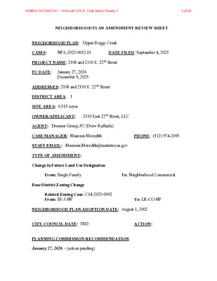
NEIGHBORHOOD PLAN AMENDMENT REVIEW SHEET NEIGHORHOOD PLAN: Upper Boggy Creek CASE#: NPA-2025-0012.01 DATE FILED: September 4, 2025 PROJECT NAME: 2108 and 2110 E. 22nd Street PC DATE: January 27, 2026 December 9, 2025 ADDRESS/ES: 2108 and 2110 E. 22nd Street DISTRICT AREA: 1 SITE AREA: 0.515 acres OWNER/APPLICANT: 2110 East 22nd Street, LLC AGENT: Drenner Group, PC (Drew Raffaele) CASE MANAGER: Maureen Meredith PHONE: (512) 974-2695 STAFF EMAIL: Maureen.Meredith@austintexas.gov TYPE OF AMENDMENT: Change in Future Land Use Designation From: Single Family To: Neighborhood Commercial Base District Zoning Change Related Zoning Case: C14-2025-0092 From: SF-3-NP To: LR-CO-NP NEIGHBORHOOD PLAN ADOPTION DATE: August 1, 2002 CITY COUNCIL DATE: TBD ACTION: PLANNING COMMISSION RECOMMENDATION: January 27, 2026 – (action pending) 08 NPA-2025-0012.01 - 2108 and 2110 E. 22nd Street; District 11 of 30 December 9, 2025 – Postponed to January 27, 2026 at the request of the Neighborhood. [F. Maxwell – 1st; J. Hiller – 2nd] Vote: 10-0 [A. Wood and P. Howard absent. One vacancy on the dais]. STAFF RECOMMENDATION: Staff supports the applicant’s request for Neighborhood Commercial land use. BASIS FOR STAFF’S RECOMMENDATION: The applicant proposes to change the land use on the future land use map for the properties from Single Family to Neighborhood Commercial land use to build a small-scale restaurant with office space and a garden. Neighborhood Commercial land use is appropriate in this location because it can serve as a transition buffer between the single family land uses to the south and the Mixed Use land uses to the north. The property is approximately 150 feet south of Manor Road, which is an Activity Corridor. The property is near multiple public transportation routes along Manor Road, E. MLK Jr. Blvd, and Chicon Street. The property is less than a mile from the MLK Rail Station. The Upper Boggy Creek Neighborhood Plan supports neighborhood-scale local businesses, although it does not support converting residential properties to commerical development. Although the property is zoned SF-3-NP, there is no existing single family home on the site 08 NPA-2025-0012.01 - 2108 and 2110 E. 22nd Street; District 12 of 30 but is currently a garden and parking for an adjacent restaurant. Staff believes the location of these properties adjacent to the properties that front onto Manor Road will service as a buffer between the single family uses to the south and the commercial uses along Manor Road. LAND USE DESCRIPTIONS: EXISTING LAND …
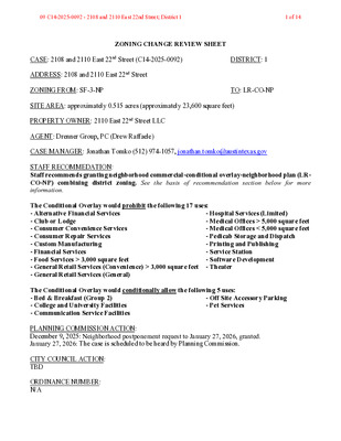
ZONING CHANGE REVIEW SHEET CASE: 2108 and 2110 East 22nd Street (C14-2025-0092) DISTRICT: 1 ADDRESS: 2108 and 2110 East 22nd Street ZONING FROM: SF-3-NP TO: LR-CO-NP SITE AREA: approximately 0.515 acres (approximately 23,600 square feet) PROPERTY OWNER: 2110 East 22nd Street LLC AGENT: Drenner Group, PC (Drew Raffaele) CASE MANAGER: Jonathan Tomko (512) 974-1057, jonathan.tomko@austintexas.gov STAFF RECOMMEDATION: Staff recommends granting neighborhood commercial-conditional overlay-neighborhood plan (LR- CO-NP) combining district zoning. See the basis of recommendation section below for more information. The Conditional Overlay would prohibit the following 17 uses: - Alternative Financial Services - Club or Lodge - Consumer Convenience Services - Consumer Repair Services - Custom Manufacturing - Financial Services - Food Services > 3,000 square feet - General Retail Services (Convenience) > 3,000 square feet - General Retail Services (General) - Hospital Services (Limited) - Medical Offices > 5,000 square feet - Medical Offices < 5,000 square feet - Pedicab Storage and Dispatch - Printing and Publishing - Service Station - Software Development - Theater The Conditional Overlay would conditionally allow the following 5 uses: - Bed & Breakfast (Group 2) - College and University Facilities - Communication Service Facilities - Off Site Accessory Parking - Pet Services PLANNING COMMISSION ACTION: December 9, 2025: Neighborhood postponement request to January 27, 2026, granted. January 27, 2026: The case is scheduled to be heard by Planning Commission. CITY COUNCIL ACTION: TBD ORDINANCE NUMBER: N/A 09 C14-2025-0092 - 2108 and 2110 East 22nd Street; District 11 of 14 ISSUES: N/A CASE MANAGER COMMENTS: The subject tract is located at the northwest corner of East 22nd Street and Coleto Street. It is a ½ block south from Manor Road. The tract is currently the Este community garden. To the north is the Este restaurant and bar Toti which front Manor Road to the north. To the east (across Coleto Street) are three single family homes. To the south (across East 22nd Street) are three single family homes. To the west is one single family home. The applicant seeks to preserve a community garden on a portion of the site. Staff noted that the site is also encumbered by a capitol view corridor. The subject tract is located approximately 168 feet south of Manor Road which is an Imagine Austin Activity Corridor and part of the ASMP Transit Priority Network. The site is also approximately ¼ mile from the MLK Station Imagine Austin Activity …
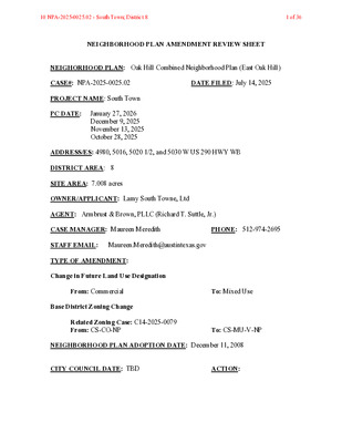
NEIGHBORHOOD PLAN AMENDMENT REVIEW SHEET NEIGHORHOOD PLAN: Oak Hill Combined Neighborhood Plan (East Oak Hill) CASE#: NPA-2025-0025.02 DATE FILED: July 14, 2025 PROJECT NAME: South Town PC DATE: January 27, 2026 December 9, 2025 November 13, 2025 October 28, 2025 ADDRESS/ES: 4980, 5016, 5020 1/2, and 5030 W US 290 HWY WB DISTRICT AREA: 8 SITE AREA: 7.008 acres OWNER/APPLICANT: Lamy South Towne, Ltd AGENT: Armbrust & Brown, PLLC (Richard T. Suttle, Jr.) CASE MANAGER: Maureen Meredith PHONE: 512-974-2695 STAFF EMAIL: Maureen.Meredith@austintexas.gov TYPE OF AMENDMENT: Change in Future Land Use Designation From: Commercial To: Mixed Use Base District Zoning Change Related Zoning Case: C14-2025-0079 From: CS-CO-NP To: CS-MU-V-NP NEIGHBORHOOD PLAN ADOPTION DATE: December 11, 2008 CITY COUNCIL DATE: TBD ACTION: 10 NPA-2025-0025.02 - South Town; District 81 of 36 PLANNING COMMISSION RECOMMENDATION: January 27, 2026 - (action pending) December 9, 2025 – Postponed to January 27, 2026 at the request of the Applicant. [F. Maxwell – 1st: J. Hiller – 2nd] Vote: 10-0 [A. Woods and P. Howard absent. One vacancy on the dais]. November 13, 2025 - Approved on the consent agenda the Neighborhood’s request for postponement to December 9, 2025. [Breton – 1st; Bedrosian – 2nd] Vote: 10-0 [F. Maxwell and P. Howard absent. One vacancy on the dais]. October 28, 2025 – Postponed to November 13, 2025 on the consent agenda at the request of the Neighborhood. [P. Breton – 1st; J. Hiller – 2nd] Vote: 11-0 [A. Lan absent. One vacancy on the dais]. STAFF RECOMMENDATION: Staff supports the Applicant’s request for Mixed Use land use. BASIS FOR STAFF’S RECOMMENDATION: The property is located at the northeast corner of West Texas Hwy 71/Southwest Parkway and South MOPAC Expressway. The site currently has a Best Buy store with several other smaller businesses. The applicant proposes to rezone the property to allow for a multifamily development. The proposed residential development will provide additional housing for the City and the planning area. The applicant’s request to change the future land use map from Commercial to Mixed Use is supported by staff because this land use is appropriate adjacent to two major highways. 10 NPA-2025-0025.02 - South Town; District 82 of 36 Below are goals from the Oak Hill Combined Neighborhood Plan staff believe supports the applicant’s request: Land Use Goals: 10 NPA-2025-0025.02 - South Town; District 83 of 36 Housing Goals: 10 NPA-2025-0025.02 - South Town; District 84 of …
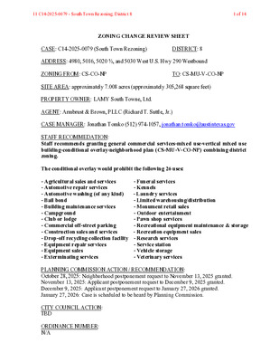
ZONING CHANGE REVIEW SHEET CASE: C14-2025-0079 (South Town Rezoning) DISTRICT: 8 ADDRESS: 4980, 5016, 5020 ½, and 5030 West U.S. Hwy 290 Westbound ZONING FROM: CS-CO-NP TO: CS-MU-V-CO-NP SITE AREA: approximately 7.008 acres (approximately 305,268 square feet) PROPERTY OWNER: LAMY South Towne, Ltd. AGENT: Armbrust & Brown, PLLC (Richard T. Suttle, Jr.) CASE MANAGER: Jonathan Tomko (512) 974-1057, jonathan.tomko@austintexas.gov STAFF RECOMMEDATION: Staff recommends granting general commercial services-mixed use-vertical mixed use building-conditional overlay-neighborhood plan (CS-MU-V-CO-NP) combining district zoning. The conditional overlay would prohibit the following 26 uses: - Agricultural sales and services - Automotive repair services - Automotive washing (of any kind) - Bail bond - Building maintenance services - Campground - Club or lodge - Commercial off-street parking - Construction sales and services - Drop-off recycling collection facility - Equipment repair services - Equipment sales - Exterminating services - Funeral services - Kennels - Laundry services - Limited warehousing/distribution - Monument retail sales - Outdoor entertainment - Pawn shop services - Recreational equipment maintenance & storage - Recreation equipment sales - Research services - Service station - Vehicle storage - Veterinary services PLANNING COMMISSION ACTION / RECOMMENDATION: October 28, 2025: Neighborhood postponement request to November 13, 2025 granted. November 13, 2025: Applicant postponement request to December 9, 2025 granted. December 9, 2025: Applicant postponement request to January 27, 2026 granted. January 27, 2026: Case is scheduled to be heard by Planning Commission. CITY COUNCIL ACTION: TBD ORDINANCE NUMBER: N/A 11 C14-2025-0079 - South Town Rezoning; District 81 of 14 ISSUES: N/A CASE MANAGER COMMENTS: The property in question is currently approximately 65,000 square feet of commercial shopping constructed in the 1990s with approximately 80,000 square feet of paved parking and approximately 10,000 square feet of commercial outparcels with an additional approximately 20,000 square feet of paved parking. It is bound to the northwest, west, and south by highways and a major highway interchange of W. US 290 Hwy. and South Mopac Expy. (ASMP Level 4 roadways maintained by TxDOT). To the north and northeast is Gaines Creek Greenbelt Open Space. To the east is an approximately 135,000 square feet of commercial shopping (Sam’s warehouse club) constructed in approximately 1991 with approximately 200,000 square feet of paved parking. To the south are additional commercial outparcels. South of W. US 290 Hwy. is a Wal-Mart and additional intense commercial development. BASIS OF RECOMMENDATION: Zoning should promote the policy of locating retail and …
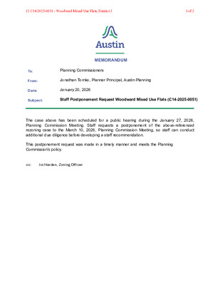
MEMORANDUM Planning Commissioners Jonathan Tomko, Planner Principal, Austin Planning January 20, 2026 To: From: Date: Subject: Staff Postponement Request Woodward Mixed Use Flats (C14-2025-0051) The case above has been scheduled for a public hearing during the January 27, 2026, Planning Commission Meeting. Staff requests a postponement of the above-referenced rezoning case to the March 10, 2026, Planning Commission Meeting, so staff can conduct additional due diligence before developing a staff recommendation. This postponement request was made in a timely manner and meets the Planning Commission’s policy. cc: Joi Harden, Zoning Officer 12 C14-2025-0051 - Woodward Mixed Use Flats; District 31 of 2 12 C14-2025-0051 - Woodward Mixed Use Flats; District 32 of 2
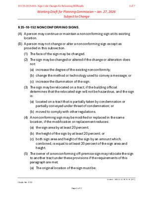
Working Draft for Planning Commission – Jan. 27, 2026 Subject to Change § 25-10-152 NONCONFORMING SIGNS. (A) A person may continue or maintain a nonconforming sign at its existing location. (B) A person may not change or alter a nonconforming sign except as provided in this subsection. (1) The face of the sign may be changed. (2) The sign may be changed or altered if the change or alteration does not: (a) increase the degree of the existing nonconformity; (b) change the method or technology used to convey a message; or (c) increase the illumination of the sign. (3) The sign may be relocated on a tract, if the building official determines that the relocated sign will not be hazardous, and the sign is: (a) located on a tract that is partially taken by condemnation or partially conveyed under threat of condemnation; or (b) moved to comply with other regulations. (4) A nonconforming sign may be modified or replaced in the same location, if the modification or replacement reduces: (a) the sign area by at least 20 percent; (b) the height of the sign by at least 20 percent; or (c) both sign area and height of the sign by an amount which, combined, is equal to at least 20 percent of the sign area and height. (5) The owner of a nonconforming off-premise sign may relocate the sign to another tract under these provisions if the requirements of this paragraph are met. (a) The original location of the sign must be: (Supp. No. 172) Created: 2025-12-22 09:53:44 [EST] Page 1 of 7 18 C20-2025-008 - Sign Code Changes for Relocating Billboards1 of 7 Working Draft for Planning Commission – Jan. 27, 2026 Subject to Change (i) in the area bounded by Highway 183 from Burnet Road to Highway 71, Highway 71 from Highway 183 to Lamar Boulevard, Lamar Boulevard from Highway 71 to 45th Street, 45th Street from Lamar Boulevard to Burnet Road, and Burnet Road from 45th Street to Highway 183, or on a tract that abuts the street right-of-way of a boundary street; (ii) in a scenic roadway sign district; (iii) within 500 feet of: 1. a historic sign district; or 2. a residential structure located in a residential base zoning district; or (iv) within the boundaries of a registered neighborhood association that has requested removal of the sign; or (v) on a tract that is partially …
From: W Williams < Sent: Tuesday, January 13, 2026 4:53 PM To: Love, Danielle <danielle.love@austintexas.gov> Subject: I am requesting your support to stop commercial development in the Blackland Neighborhood Please help protect the Blackland Neighborhood from unjust commercialization because once one lot is rezoned “commercial”, dominos will fall and this part of the Historic African American Cultural Heritage District will disappear. Native Austin residents Willie Williams From: Sent: Monday, January 12, 2026 6:25 PM To: Love, Danielle <danielle.love@austintexas.gov> Subject: Blackland Neighborhood I am a native Austinite. I am against the re-zoning of the Blackland Neighborhood. Please leave our neighborhoods alone. Mrs. Nancy Thompson From: Stuart King < Sent: Tuesday, January 13, 2026 4:37 PM To: Love, Danielle <danielle.love@austintexas.gov> Subject: No more zoning Changes We have had enough of cars on East 21st-East 22nd Street. Density is crazy. Mr. Stuart King, F.D.I.C. Funeral Director/Owner King Tears Mortuary, Inc. "The Place for A Perfect Tribute" 08 NPA-2025-0012.01 - 2108 and 2110 E. 22nd Street; District 11 of 2 From: Rosalie Boldin < Sent: Tuesday, January 20, 2026 12:36 PM To: Love, Danielle <danielle.love@austintexas.gov> Subject: re-zoning request for 2108 East 22nd Street We have been notified that you have been requested to re-zone 2108 East 22nd Street from single family residential to commercial. We oppose this re-zoning request. We believe that this request erodes and will continue the erosion of the Blackland Neighborhood, part of the African American Cultural Heritage District, a significant part of Austin and its history. We strongly believe it is important for the City of Austin to respect and retain its history. We Do Not support the erosion of DEI in today's US and Texas politics. We Do Not support efforts to edit our history to prevent future generations from understanding the challenges the United States, and thereby, Texas, have confronted to hold onto it founding principles. As residents of the Barton Hills neighborhood, we also highly value the ability of neighborhoods to maintain their integrity! Should the owner of Este Restaurant be allowed to pursue his commercial interests at the expense of the (historic) neighborhood's residents, then we will no longer dine at Este, one of our favorite restaurants. Rosalie and Jim Boldin 08 NPA-2025-0012.01 - 2108 and 2110 E. 22nd Street; District 12 of 2
From: W Williams < Sent: Tuesday, January 13, 2026 4:53 PM To: Love, Danielle <danielle.love@austintexas.gov> Subject: I am requesting your support to stop commercial development in the Blackland Neighborhood Please help protect the Blackland Neighborhood from unjust commercialization because once one lot is rezoned “commercial”, dominos will fall and this part of the Historic African American Cultural Heritage District will disappear. Native Austin residents Willie Williams From: Sent: Monday, January 12, 2026 6:25 PM To: Love, Danielle <danielle.love@austintexas.gov> Subject: Blackland Neighborhood I am a native Austinite. I am against the re-zoning of the Blackland Neighborhood. Please leave our neighborhoods alone. Mrs. Nancy Thompson From: Stuart King < Sent: Tuesday, January 13, 2026 4:37 PM To: Love, Danielle <danielle.love@austintexas.gov> Subject: No more zoning Changes We have had enough of cars on East 21st-East 22nd Street. Density is crazy. Mr. Stuart King, F.D.I.C. Funeral Director/Owner King Tears Mortuary, Inc. "The Place for A Perfect Tribute" 09 C14-2025-0092 - 2108 and 2110 East 22nd Street; District 11 of 2 From: Rosalie Boldin < Sent: Tuesday, January 20, 2026 12:36 PM To: Love, Danielle <danielle.love@austintexas.gov> Subject: re-zoning request for 2108 East 22nd Street We have been notified that you have been requested to re-zone 2108 East 22nd Street from single family residential to commercial. We oppose this re-zoning request. We believe that this request erodes and will continue the erosion of the Blackland Neighborhood, part of the African American Cultural Heritage District, a significant part of Austin and its history. We strongly believe it is important for the City of Austin to respect and retain its history. We Do Not support the erosion of DEI in today's US and Texas politics. We Do Not support efforts to edit our history to prevent future generations from understanding the challenges the United States, and thereby, Texas, have confronted to hold onto it founding principles. As residents of the Barton Hills neighborhood, we also highly value the ability of neighborhoods to maintain their integrity! Should the owner of Este Restaurant be allowed to pursue his commercial interests at the expense of the (historic) neighborhood's residents, then we will no longer dine at Este, one of our favorite restaurants. Rosalie and Jim Boldin 09 C14-2025-0092 - 2108 and 2110 East 22nd Street; District 12 of 2
13 C14-2025-0090 - West Martin Luther King Jr Blvd and Nueces Street; District 91 of 6 13 C14-2025-0090 - West Martin Luther King Jr Blvd and Nueces Street; District 92 of 6 13 C14-2025-0090 - West Martin Luther King Jr Blvd and Nueces Street; District 93 of 6 January 16, 2026 To Whom it May Concern Sent by email only to: Megan Meisenbach at Subject: Environmental Evaluation of Former Jack Brown Cleaners Site 615 W. Martin Luther King, Jr. Blvd.; Austin, Texas Dear Ms. Meisenbach: As you requested, this letter report summarizes the results of my evaluation of environmental conditions and potential human health effects due to releases of dry cleaning chemicals from the former Jack Brown Cleaners (JBC) property (Site) located at 615 W. Martin Luther King, Jr. Blvd in Austin, Texas. I summarize background information regarding the Site history, presence of dry cleaning chemical contamination in soil and groundwater at the Site and at nearby properties, regulatory status with the Texas Commission on Environmental Quality (TCEQ), and environmental risks if the Site is redeveloped for commercial or residential use. Summary and Conclusions From my review of the JBC Site VCP documents, I draw the following conclusions: ▪ The Site soil and groundwater are contaminated with high concentrations of the dry cleaning chemical Tetrachloroethylene (PCE) and its degradation by-product chemicals, including Trichloroethylene (TCE) and Vinyl Chloride (VC). The chemicals are present at levels exceeding indoor air human health limits for vapor migration into current and future buildings. Further, PCE in groundwater has exceeded TCEQ limits for outdoor air exposures. It is notable that the U.S. Environmental Protection Agency is sufficiently concerned about PCE’s toxicity (and that of TCE and VC) that the agency is phasing out nearly all uses of this chemical. ▪ It is my opinion that the Texas Commission on Environmental Quality (TCEQ) inappropriately approved JBC’s request to cease Site cleanup and monitoring. The Voluntary Cleanup Program (VCP) Certificate of Completion granted to JBC means that they and future property owners have no further obligations to cleanup and protect on-site residents, visitors, and workers from cancer risks despite the potential that indoor and outdoor air quality could exceed human health safe limits. ▪ Regardless of TCEQ’s previous actions, future development plans for the JBC property should address these potential human health risks that likely will remain for decades unless the Site is properly remediated or building measures …
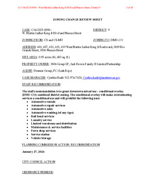
ZONING CHANGE REVIEW SHEET CASE: C14-2025-0090 - W. Martin Luther King Jr Blvd and Nueces Street DISTRICT: 9 ZONING FROM: CS and CS-MU ZONING TO: DMU-CO ADDRESS: 601, 607, 611, 615, 619 West Martin Luther King Jr Boulevard, 1809 Rio Grande Street, 1806 Nueces Street SITE AREA: 0.95 acres (41, 403 sq. ft.) PROPERTY OWNER: 1806 Group LP, Jack Brown Family II Limited Partnership AGENT: Drenner Group, PC (Leah Bojo) CASE MANAGER: Cynthia Hadri 512-974-7620, Cynthia.hadri@austintexas.gov STAFF RECOMMENDATION: The staff recommendation is to grant downtown mixed use – conditional overlay (DMU-CO) combined district zoning. The conditional overlay will make exterminating services a conditional use and will prohibit the following uses: Automotive rentals Automotive repair services Automotive sales Automotive washing (of any type) Bail bond services Laundry service Limited warehouse and distribution Maintenance & service facilities Pawn shop services Service station Vehicle Storage PLANNING COMMISSION ACTION / RECOMMENDATION: January 27, 2026: CITY COUNCIL ACTION: ORDINANCE NUMBER: 13 C14-2025-0090 - West Martin Luther King Jr Blvd and Nueces Street; District 91 of 43 C14-2025-0090 ISSUES: 2 Staff is aware that the property owner has submitted an application for the Density Bonus Program. However, the current rezoning request for Downtown Mixed Use – Conditional Overlay (DMU-CO) would allow for a maximum of 120 feet in height. CASE MANAGER COMMENTS: The property in question is approximately 0.95 acres, is developed with a Laundry Service (Jack Brown Cleaners) Fast food (Jimmy Johns) and Bakery (Tiff’s Treats). The existing zoning for the property is general commercial services (CS) district zoning and general commercial services – mixed use (CS-MU) combined district zoning. There is access to West Martin Luther King Jr Boulevard (level 3), Nueces Street (level 1), Rio Grande Street (level 1) and the alley, which is set to remain. This site is in the Northwest District of the Downtown Area Plan and is characterized as mixed use. The surrounding area has several office and commercial uses around it (GO; GO-MU; DMU-CO; CS; CS-NP; DMU-H- ETOD-DBETOD; GO-ETOD-DBETOD) along with various residential types such as single family residential and multifamily residential (SF-3-H; GO). Please refer to Exhibits A (Zoning Map) and B (Aerial View). The applicant is requesting the downtown mixed use – conditional overlay (DMU-CO) combined zoning district for a unified development that will consist of approximately 435 dwelling units, retail and a hotel. The …
14 C14-2025-0093 - West 18th & Nueces Street; District 91 of 6 14 C14-2025-0093 - West 18th & Nueces Street; District 92 of 6 14 C14-2025-0093 - West 18th & Nueces Street; District 93 of 6 January 16, 2026 To Whom it May Concern Sent by email only to: Megan Meisenbach at Subject: Environmental Evaluation of Former Jack Brown Cleaners Site 615 W. Martin Luther King, Jr. Blvd.; Austin, Texas Dear Ms. Meisenbach: As you requested, this letter report summarizes the results of my evaluation of environmental conditions and potential human health effects due to releases of dry cleaning chemicals from the former Jack Brown Cleaners (JBC) property (Site) located at 615 W. Martin Luther King, Jr. Blvd in Austin, Texas. I summarize background information regarding the Site history, presence of dry cleaning chemical contamination in soil and groundwater at the Site and at nearby properties, regulatory status with the Texas Commission on Environmental Quality (TCEQ), and environmental risks if the Site is redeveloped for commercial or residential use. Summary and Conclusions From my review of the JBC Site VCP documents, I draw the following conclusions: ▪ The Site soil and groundwater are contaminated with high concentrations of the dry cleaning chemical Tetrachloroethylene (PCE) and its degradation by-product chemicals, including Trichloroethylene (TCE) and Vinyl Chloride (VC). The chemicals are present at levels exceeding indoor air human health limits for vapor migration into current and future buildings. Further, PCE in groundwater has exceeded TCEQ limits for outdoor air exposures. It is notable that the U.S. Environmental Protection Agency is sufficiently concerned about PCE’s toxicity (and that of TCE and VC) that the agency is phasing out nearly all uses of this chemical. ▪ It is my opinion that the Texas Commission on Environmental Quality (TCEQ) inappropriately approved JBC’s request to cease Site cleanup and monitoring. The Voluntary Cleanup Program (VCP) Certificate of Completion granted to JBC means that they and future property owners have no further obligations to cleanup and protect on-site residents, visitors, and workers from cancer risks despite the potential that indoor and outdoor air quality could exceed human health safe limits. ▪ Regardless of TCEQ’s previous actions, future development plans for the JBC property should address these potential human health risks that likely will remain for decades unless the Site is properly remediated or building measures incorporated to prevent migration of toxic chemical gases into the buildings. In …
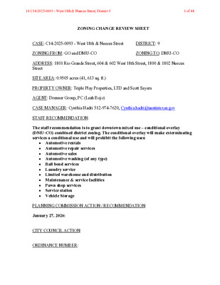
ZONING CHANGE REVIEW SHEET CASE: C14-2025-0093 - West 18th & Nueces Street DISTRICT: 9 ZONING FROM: GO and DMU-CO ZONING TO: DMU-CO ADDRESS: 1801 Rio Grande Street, 604 & 602 West 18th Street, 1800 & 1802 Nueces Street SITE AREA: 0.9505 acres (41, 613 sq. ft.) PROPERTY OWNER: Triple Play Properties, LTD and Scott Sayers AGENT: Drenner Group, PC (Leah Bojo) CASE MANAGER: Cynthia Hadri 512-974-7620, Cynthia.hadri@austintexas.gov STAFF RECOMMENDATION: The staff recommendation is to grant downtown mixed use – conditional overlay (DMU-CO) combined district zoning. The conditional overlay will make exterminating services a conditional use and will prohibit the following uses: Automotive rentals Automotive repair services Automotive sales Automotive washing (of any type) Bail bond services Laundry service Limited warehouse and distribution Maintenance & service facilities Pawn shop services Service station Vehicle Storage PLANNING COMMISSION ACTION / RECOMMENDATION: January 27, 2026: CITY COUNCIL ACTION: ORDINANCE NUMBER: 14 C14-2025-0093 - West 18th & Nueces Street; District 91 of 44 C14-2025-0093 ISSUES: 2 Staff is aware that the property owner has submitted an application for the Density Bonus Program. However, the current rezoning request for Downtown Mixed Use – Conditional Overlay (DMU-CO) would allow for a maximum of 120 feet in height. CASE MANAGER COMMENTS: The property in question is approximately 0.95 acres, is developed with multifamily (Penthouse Apartments – 48 units) and an office building. The existing zoning for the property is (GO) district zoning and (DMU-CO) combined district zoning. There is access to Rio Grande Street (level 1), West 18th Street (level 1), Nueces Street (level 1) and the alley, which is set to remain. This site is in the Northwest District of the Downtown Area Plan and is characterized as a mixed use. The surrounding area has several office and commercial uses around it (GO; GO-MU; DMU-CO; CS; CS-NP; DMU-H-ETOD-DBETOD; GO-ETOD- DBETOD) along with various residential types such as single family residential and multifamily residential (SF-3-H; GO). Please refer to Exhibits A (Zoning Map) and B (Aerial View). The applicant is requesting the downtown mixed use – conditional overlay (DMU-CO) combined zoning district for a unified development that will consist of approximately 435 dwelling units, retail and a hotel. The staff is recommending DMU-CO here with a list of prohibited uses and with the knowledge that the maximum height allowed in the DMU district is 120 feet. Half …
Leah M. Bojo lbojo@drennergroup.com 512-807-2918 Ms. Lauren Middleton-Pratt Planning Department City of Austin 6310 Wilhelmina Delco Drive Austin, TX 78752 January 21, 2026 Via Electronic Delivery Re: C14-2024-0147, C14-06-0117(RCT) and C14-72-299(RCT) - Postponement request for the zoning and restrictive covenant termination cases associated with the property located at 1317 and 1405 E. Riverside Drive, Austin, Texas (the “Property”). Dear Ms. Middleton-Pratt: As representatives of the owner of the Property, we respectfully request a postponement of zoning case numbers C14-2024-0147, C14-06-0117(RCT) and C14-72-299(RCT) on the January 27, 2026 Planning Commission agenda to the February 24, 2026 Planning Commission agenda. Please let me know if you have any questions or if we can provide any additional information. Thank you for your time and attention to this matter. Sincerely, Leah M. Bojo cc: Nancy Estrada, Planning Department (via electronic delivery) Joi Harden, Planning Department (via electronic delivery) 2705 Bee Cave Road, Suite 100 | Austin, Texas 78746 | 512-807-2900 | www.drennergroup.com 15 C14-2024-0147 - 1405 East Riverside Drive; District 91 of 1
Leah M. Bojo lbojo@drennergroup.com 512-807-2918 Ms. Lauren Middleton-Pratt Planning Department City of Austin 6310 Wilhelmina Delco Drive Austin, TX 78752 January 21, 2026 Via Electronic Delivery Re: C14-2024-0147, C14-06-0117(RCT) and C14-72-299(RCT) - Postponement request for the zoning and restrictive covenant termination cases associated with the property located at 1317 and 1405 E. Riverside Drive, Austin, Texas (the “Property”). Dear Ms. Middleton-Pratt: As representatives of the owner of the Property, we respectfully request a postponement of zoning case numbers C14-2024-0147, C14-06-0117(RCT) and C14-72-299(RCT) on the January 27, 2026 Planning Commission agenda to the February 24, 2026 Planning Commission agenda. Please let me know if you have any questions or if we can provide any additional information. Thank you for your time and attention to this matter. Sincerely, Leah M. Bojo cc: Nancy Estrada, Planning Department (via electronic delivery) Joi Harden, Planning Department (via electronic delivery) 2705 Bee Cave Road, Suite 100 | Austin, Texas 78746 | 512-807-2900 | www.drennergroup.com 16 C14-06-0117(RCT) - 1317 and 1405 East Riverside Drive; District 91 of 1
Leah M. Bojo lbojo@drennergroup.com 512-807-2918 Ms. Lauren Middleton-Pratt Planning Department City of Austin 6310 Wilhelmina Delco Drive Austin, TX 78752 January 21, 2026 Via Electronic Delivery Re: C14-2024-0147, C14-06-0117(RCT) and C14-72-299(RCT) - Postponement request for the zoning and restrictive covenant termination cases associated with the property located at 1317 and 1405 E. Riverside Drive, Austin, Texas (the “Property”). Dear Ms. Middleton-Pratt: As representatives of the owner of the Property, we respectfully request a postponement of zoning case numbers C14-2024-0147, C14-06-0117(RCT) and C14-72-299(RCT) on the January 27, 2026 Planning Commission agenda to the February 24, 2026 Planning Commission agenda. Please let me know if you have any questions or if we can provide any additional information. Thank you for your time and attention to this matter. Sincerely, Leah M. Bojo cc: Nancy Estrada, Planning Department (via electronic delivery) Joi Harden, Planning Department (via electronic delivery) 2705 Bee Cave Road, Suite 100 | Austin, Texas 78746 | 512-807-2900 | www.drennergroup.com 17 C14-72-299(RCT) - 1317 and 1405 East Riverside Drive; District 91 of 1
PLANNING COMMISSION MEETING MINUTES Tuesday, January 13, 2026 PLANNING COMMISSION MEETING MINUTES REGULAR MEETING TUESDAY, JANUARY 13, 2026 The Planning Commission convened in a regular on Tuesday, January 13, 2026, at Austin City Hall, Council Chambers, Room 1001, 301 W. Second Street, in Austin, Texas. Chair Woods called the Planning Commission Meeting to order at 6:05 p.m. Commissioners in Attendance: Felicity Maxwell Casey Haney Anna Lan Joshua Hiller Peter Breton Danielle Skidmore Brian Bedrosian Imad Ahmed Alice Woods Commissioners in Attendance Remotely: Nadia Barrera-Ramirez Adam Powell Ex-Officio Members Present: Jessica Cohen Ex-Officio Members in Absent: TC Broadnax Candace Hunter Richard Mendoza 2 Vacancies on the Dais PUBLIC COMMUNICATION: GENERAL None present. 1 PLANNING COMMISSION MEETING MINUTES Tuesday, January 13, 2026 APPROVAL OF MINUTES 1. Approve the minutes of the Planning Commission regular meeting on Tuesday, December 16, 2025. The minutes from the meeting of Tuesday, December 16, 2025, were approved on the consent agenda on Secretary Maxwell’s motion, Commissioner Breton’s second, on an 11-0 vote. 2 vacancies on the dais. PUBLIC HEARINGS 2. Plan Amendment: NPA-2025-0025.03 - Lantana Tract 34; District 8 Location: 7009 West William Cannon Drive, Williamson Creek Watershed; Oak Hill Combined (West Oak Hill) Neighborhood Planning Area Owner/Applicant: Stratus Properties Operating Company Armbrust & Brown, PLLC (Jewels Cain) Agent: Office to Commercial land use Request: Recommended Staff Rec.: Maureen Meredith, 512-974-2695, maureen.meredith@austintexas.gov Staff: Austin Planning The public hearing was closed on Commissioner Breton’s motion, Vice Chair Haney’s second, on a 11-0 vote. 2 vacancies on the dais. The motion to remove the following uses from the prohibited list: the plant nursery, theater, college and university, research services, printing and publishing, and general retail over 3000 square feet, was approved on Secretary Maxwell’s motion, Parliamentarian Ahmed’s second, on an 11-0 vote. 2 vacancies on the dais. The motion to approve Staff’s recommendation of Commercial land use for NPA-2025- 0025.03 - Lantana Tract 34; District 8, as amended, located at 7009 West William Cannon Drive, was approved on Commissioner Breton’s motion, Vice Chair Haney’s second, on an 11-0 vote. 2 vacancies on the dais. 3. Rezoning: Location: C14-2025-0087 - Lantana Tract 34; District 8 6941 ½ and 7009 West William Cannon Drive, Williamson Creek Watershed; Oak Hill Combined (West Oak Hill) Neighborhood Planning Area Owner/Applicant: Stratus Properties Operating Company Armbrust & Brown, PLLC (Jewels Cain) Agent: GO-NP to GR-CO-NP Request: Recommended Staff Rec.: Jonathan Tomko, 512-974-1057, jonathan.tomko@austintexas.gov Staff: Austin …
Alex Moreland and Kevin Urrutia-O’Reilly 3102 Lafayette Ave Austin, TX 78722 To: City of Austin Planning and Zoning Department January 21, 2026 Re.: Zoning Case # C14-2025-009 Rezoning of 2108 and 2110 East 22nd Street Dear Planning Commission, We are writing to express our support for the rezoning of 2108 and 2110 East 22nd Street. We live just down the road from Este on Lafayette Avenue. Our family has deep roots in this neighborhood: my mother lives five houses away from us, and my grandparents lived in the house across the street from us in the 1950s. Individually and collectively, we have witnessed the neighborhood’s changes over many decades. When Eastside Cafe sold, we were delighted to learn that the new owner planned to rebuild the restaurant and revive the garden after years of neglect. We have long enjoyed watching the Purple Martins, North America’s largest swallow, return year after year from South America to their thriving colony at the corner of 22nd and Coleto. Our appreciation for this space led us to volunteer as caretakers of the Purple Martin houses; this will be our sixth season volunteering at the site. Throughout our time in the garden, we have met countless neighbors and passersby who are excited to learn what is currently growing and what will be planted next. Este garden hosts tours, classes, and sunflower-picking days. It has truly become a pillar of the Blackland and Cherrywood neighborhoods. And like all gardens, much like our city, it is ever evolving and always changing. While we understand that some neighbors have concerns about parking, it is prudent to consider the realistic alternatives if this business did not exist in this space. This project represents a thoughtful use of the property: it preserves the existing garden, maintains parking, and strengthens the neighborhood in ways that many other potential developments would not. The positive impact on the local economy, neighborhood vibrancy, and sense of community should not be overlooked. In addition to being garden volunteers, we are regular patrons of both Este and Bar Toti. Over the three years of visiting these restaurants, we have seen remarkably little staff turnover. It is clear that the owner, Sam, values and respects his employees, and that care is returned in kind. It is rare to see development carried out with such thoughtfulness and genuine concern for the surrounding area, as demonstrated by the entire …
To: Maureen Meredith Senior Planner City of Austin Planning Jonathan Tomko Planner Principal City of Austin Planning Planning Commission From: Marva Overton President Blackland Neighborhood Association Re: Zoning Case: NPA-2025-0012.01 and C14-2025-0092 Date: January 27, 2026 On behalf of the Blackland Neighborhood Association (BNA) I am writing to state that the association does not support the zoning request referenced above. While there have been various meetings and conversations with Drew Raffaele, Drenner Group, and/or the property owner, Sam Hellman-Mass, it did not ultimately yield a solution that the association felt it could support. Below are the concerns, some of which were previously expressed, that resulted in the no vote: Encroachment of commercial buildings into residential portion of the neighborhood– While the existing FLUM supports the development of businesses along the Manor Road corridor, the proposed rezoning will allow commercial development on interior streets which the plan does not support. This action could set a precedent for similar requests in the future. City Planning states that this request results in “equal treatment of similarly situated properties”. However, there is a major difference in that multi-family dwellings and service oriented businesses do not create the same degree of traffic that another restaurant will. Parking and Traffic – The neighborhood is already inundated with restaurant goers parking on the streets in the neighborhood. Nearby neighbors are challenged with having space for guests to park. Adding a building to serve breakfast and lunch, and offices, will compound the parking problem. The applicant states that approximately 8 parking spaces will be added to the area along the alley that is currently used for parking and that there will be approximately 52 spaces in total. We asked the applicant to do a trips per day study to help the neighborhood gauge 08 NPA-2025-0012.01 - 2108 and 2110 E. 22nd Street; District 11 of 3 what the potential increase in vehicle traffic and street parking will be. It is our position that most customers drive to the restaurant and are not walking or taking public transportation. The application stated they would not do a trips per day study prior to the zoning case decision being made because the City only requires this during the site plan review, after the layout and access are finalized. This seems counterintuitive in that the zoning change would already be approved without understanding the traffic impact. Safety – Some neighbors expressed concern …
Via Electronic Delivery January 26, 2026 Re: NPA-2025-0012.01 - 2108 and 2110 E. 22nd Street Dear Planning Commissioners, At a Special Called Meeting on January 26th, 2026, the Upper Boggy Creek Neighborhood Plan Contact Team discussed and took action to join the Blackland Neighborhood Association in their opposition to the requested Future Land Use Map (FLUM) change from Single Family to Neighborhood Commercial for the properties at 2108 and 2110 E. 22nd Street. The Contact Team would like to express its preference for a comprehensive small area plan update along the Manor Road corridor from I-35 to Airport Blvd, almost all of which is within the 2002 Upper Boggy Creek Neighborhood Plan. A comprehensive update would enable an appropriate corridor-scale view and broad resident and merchant engagement for issues like creative off-site parking management (that would address concerns with projects such as this one) and design guidelines for commercial development encroaching on interior streets and pedestrian safety enhancements such as additional sidewalks. In addition, a plan update would identify how to make best use of existing housing stock along the corridor but also encourage any future redevelopment to add transit-supportive density, including affordable housing. We appreciate your consideration of this letter and our position on this case. Jim Walker, acting UBC NPCT Chair Cc: Maureen Meredith, Planning and Zoning Department The Upper Boggy Creek Neighborhood Plan area includes six neighborhood associations: Blackland NA, Cherrywood NA, Delwood II NA, Roger Washington-Holy Cross NA, Scheiffer-Willowbrook NA, and the Wilshire Wood/Delwood I NA. 08 NPA-2025-0012.01 - 2108 and 2110 E. 22nd Street; District 11 of 1
Alex Moreland and Kevin Urrutia-O’Reilly 3102 Lafayette Ave Austin, TX 78722 To: City of Austin Planning and Zoning Department January 21, 2026 Re.: Zoning Case # C14-2025-009 Rezoning of 2108 and 2110 East 22nd Street Dear Planning Commission, We are writing to express our support for the rezoning of 2108 and 2110 East 22nd Street. We live just down the road from Este on Lafayette Avenue. Our family has deep roots in this neighborhood: my mother lives five houses away from us, and my grandparents lived in the house across the street from us in the 1950s. Individually and collectively, we have witnessed the neighborhood’s changes over many decades. When Eastside Cafe sold, we were delighted to learn that the new owner planned to rebuild the restaurant and revive the garden after years of neglect. We have long enjoyed watching the Purple Martins, North America’s largest swallow, return year after year from South America to their thriving colony at the corner of 22nd and Coleto. Our appreciation for this space led us to volunteer as caretakers of the Purple Martin houses; this will be our sixth season volunteering at the site. Throughout our time in the garden, we have met countless neighbors and passersby who are excited to learn what is currently growing and what will be planted next. Este garden hosts tours, classes, and sunflower-picking days. It has truly become a pillar of the Blackland and Cherrywood neighborhoods. And like all gardens, much like our city, it is ever evolving and always changing. While we understand that some neighbors have concerns about parking, it is prudent to consider the realistic alternatives if this business did not exist in this space. This project represents a thoughtful use of the property: it preserves the existing garden, maintains parking, and strengthens the neighborhood in ways that many other potential developments would not. The positive impact on the local economy, neighborhood vibrancy, and sense of community should not be overlooked. In addition to being garden volunteers, we are regular patrons of both Este and Bar Toti. Over the three years of visiting these restaurants, we have seen remarkably little staff turnover. It is clear that the owner, Sam, values and respects his employees, and that care is returned in kind. It is rare to see development carried out with such thoughtfulness and genuine concern for the surrounding area, as demonstrated by the entire …
To: Maureen Meredith Senior Planner City of Austin Planning Jonathan Tomko Planner Principal City of Austin Planning Planning Commission From: Marva Overton President Blackland Neighborhood Association Re: Zoning Case: NPA-2025-0012.01 and C14-2025-0092 Date: January 27, 2026 On behalf of the Blackland Neighborhood Association (BNA) I am writing to state that the association does not support the zoning request referenced above. While there have been various meetings and conversations with Drew Raffaele, Drenner Group, and/or the property owner, Sam Hellman-Mass, it did not ultimately yield a solution that the association felt it could support. Below are the concerns, some of which were previously expressed, that resulted in the no vote: Encroachment of commercial buildings into residential portion of the neighborhood– While the existing FLUM supports the development of businesses along the Manor Road corridor, the proposed rezoning will allow commercial development on interior streets which the plan does not support. This action could set a precedent for similar requests in the future. City Planning states that this request results in “equal treatment of similarly situated properties”. However, there is a major difference in that multi-family dwellings and service oriented businesses do not create the same degree of traffic that another restaurant will. Parking and Traffic – The neighborhood is already inundated with restaurant goers parking on the streets in the neighborhood. Nearby neighbors are challenged with having space for guests to park. Adding a building to serve breakfast and lunch, and offices, will compound the parking problem. The applicant states that approximately 8 parking spaces will be added to the area along the alley that is currently used for parking and that there will be approximately 52 spaces in total. We asked the applicant to do a trips per day study to help the neighborhood gauge 09 C14-2025-0092 - 2108 and 2110 East 22nd Street; District 11 of 3 what the potential increase in vehicle traffic and street parking will be. It is our position that most customers drive to the restaurant and are not walking or taking public transportation. The application stated they would not do a trips per day study prior to the zoning case decision being made because the City only requires this during the site plan review, after the layout and access are finalized. This seems counterintuitive in that the zoning change would already be approved without understanding the traffic impact. Safety – Some neighbors expressed concern …
Via Electronic Delivery January 26, 2026 Re: NPA-2025-0012.01 - 2108 and 2110 E. 22nd Street Dear Planning Commissioners, At a Special Called Meeting on January 26th, 2026, the Upper Boggy Creek Neighborhood Plan Contact Team discussed and took action to join the Blackland Neighborhood Association in their opposition to the requested Future Land Use Map (FLUM) change from Single Family to Neighborhood Commercial for the properties at 2108 and 2110 E. 22nd Street. The Contact Team would like to express its preference for a comprehensive small area plan update along the Manor Road corridor from I-35 to Airport Blvd, almost all of which is within the 2002 Upper Boggy Creek Neighborhood Plan. A comprehensive update would enable an appropriate corridor-scale view and broad resident and merchant engagement for issues like creative off-site parking management (that would address concerns with projects such as this one) and design guidelines for commercial development encroaching on interior streets and pedestrian safety enhancements such as additional sidewalks. In addition, a plan update would identify how to make best use of existing housing stock along the corridor but also encourage any future redevelopment to add transit-supportive density, including affordable housing. We appreciate your consideration of this letter and our position on this case. Jim Walker, acting UBC NPCT Chair Cc: Maureen Meredith, Planning and Zoning Department The Upper Boggy Creek Neighborhood Plan area includes six neighborhood associations: Blackland NA, Cherrywood NA, Delwood II NA, Roger Washington-Holy Cross NA, Scheiffer-Willowbrook NA, and the Wilshire Wood/Delwood I NA. 09 C14-2025-0092 - 2108 and 2110 East 22nd Street; District 11 of 1
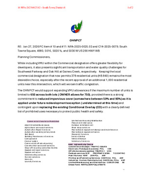
OHNPCT RE: Jan 27, 2026 PC Item # 10 and #11: NPA-2025-0025.02 and C14-2025-0079; South Towne Square, 4980, 5016, 5020 ½, and 5030 W US 290 HWY WB Planning Commissioners, While including VMU within the Commercial designation offers greater flexibility for developers, it also presents significant transportation and water quality challenges for Southwest Parkway and Oak Hill at Gaines Creek, respectively. Keeping the local commercial designation that now permits 378 residential units (HB 840) remains the most desirable choice, especially after the recent approval of an additional 1,000 residential units near this intersection, which will worsen traffic congestion. The OHNPCT would support expanding VMU allowances if the maximum number of units is limited to 650 across both lots ( OWNER allows for 750), provided there is a strong commitment to reduced impervious cover (somewhere between 50% and 95%) as it is applied under future redevelopment exception ( undetermined at this time) and contingent upon replacing the existing Conditional Overlay (CO) with a clearly defined list of prohibited uses necessary to protect public health and safety. 19Commercial Uses to be ProhibitedAdult Oriented BusinessesAgricultural sales and servicesAutomotive Repair ServicesAutomotive washing (of any kind)Bail BondBuilding Maintenance ServicesCampgroundClub or odgeCommercial off-street parkingConstruction sales and services rop-off recycling collection facilityEquipment repair servicesEquipment salesExterminating services uneral servicesKennels aundry Services imited warehousing distributionMonument retail salesOutdoor entertainmentPawn shop servicesRecreational equipment storage and maintenanceRecreational equipment salesResearch ServicesService StationVehicle StorageVeterinary Services dd greed to by OwnerConvenience torage R C E Electronic rototype ssembly O ONO site ccessorypar ing R C E edicabservicesNO RO R ENOW OCEN R C lantNursery ER ER O N rinting and ublishing ervices C E C O N ndustrial Custom anufacturing C E C O N imited Warehousing and istribution CON ON E rban arm ER ER O N 10 NPA-2025-0025.02 - South Town; District 81 of 2 A comprehensive ra ic mpact nalysis ( ) with the ite lan (SP) is necessary due to the site's complex access points, regardless of any future subdivision changes. The projection of only 180 additional daily trips across the entire site may be misrepresented by relying on 24-hour counts rather than pea travel times and may circumvent the requirement for a Traffic Impact Assessment (TIA) with individual Site Plans and subdivision. Allowing unrestricted, high-density development over South Towne’s 7 acres, as currently proposed, would deepen transportation issues, worsen water scarcity and pollution, and harm the remaining green spaces around …
OHNPCT RE: Jan 27, 2026 PC Item # 10 and #11: NPA-2025-0025.02 and C14-2025-0079; South Towne Square, 4980, 5016, 5020 ½, and 5030 W US 290 HWY WB Planning Commissioners, While including VMU within the Commercial designation offers greater flexibility for developers, it also presents significant transportation and water quality challenges for Southwest Parkway and Oak Hill at Gaines Creek, respectively. Keeping the local commercial designation that now permits 378 residential units (HB 840) remains the most desirable choice, especially after the recent approval of an additional 1,000 residential units near this intersection, which will worsen traffic congestion. The OHNPCT would support expanding VMU allowances if the maximum number of units is limited to 650 across both lots ( OWNER allows for 750), provided there is a strong commitment to reduced impervious cover (somewhere between 50% and 95%) as it is applied under future redevelopment exception ( undetermined at this time) and contingent upon replacing the existing Conditional Overlay (CO) with a clearly defined list of prohibited uses necessary to protect public health and safety. 19Commercial Uses to be ProhibitedAdult Oriented BusinessesAgricultural sales and servicesAutomotive Repair ServicesAutomotive washing (of any kind)Bail BondBuilding Maintenance ServicesCampgroundClub or odgeCommercial off-street parkingConstruction sales and services rop-off recycling collection facilityEquipment repair servicesEquipment salesExterminating services uneral servicesKennels aundry Services imited warehousing distributionMonument retail salesOutdoor entertainmentPawn shop servicesRecreational equipment storage and maintenanceRecreational equipment salesResearch ServicesService StationVehicle StorageVeterinary Services dd greed to by OwnerConvenience torage R C E Electronic rototype ssembly O ONO site ccessorypar ing R C E edicabservicesNO RO R ENOW OCEN R C lantNursery ER ER O N rinting and ublishing ervices C E C O N ndustrial Custom anufacturing C E C O N imited Warehousing and istribution CON ON E rban arm ER ER O N 11 C14-2025-0079 - South Town Rezoning; District 81 of 2 A comprehensive ra ic mpact nalysis ( ) with the ite lan (SP) is necessary due to the site's complex access points, regardless of any future subdivision changes. The projection of only 180 additional daily trips across the entire site may be misrepresented by relying on 24-hour counts rather than pea travel times and may circumvent the requirement for a Traffic Impact Assessment (TIA) with individual Site Plans and subdivision. Allowing unrestricted, high-density development over South Towne’s 7 acres, as currently proposed, would deepen transportation issues, worsen water scarcity and pollution, and harm the remaining green spaces …
13 C14-2025-0090 - West Martin Luther King Jr Blvd and Nueces Street; District 91 of 2 13 C14-2025-0090 - West Martin Luther King Jr Blvd and Nueces Street; District 92 of 2
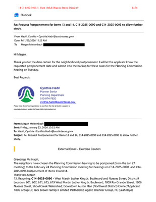
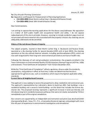
To: City of Austin Planning Commission Re: Opposition and Request for Postponement of Rezoning Applications • • C14-2025-0090 (West Martin Luther King Jr. Boulevard & Nueces Street) C14-2025-0093 (West 18th Street & Nueces Street) Dear Commissioners, January 25, 2025 I am writing to oppose the rezoning applications for the above cases/addresses. My opposition is a matter of both public health and occupational health and safety. I do not oppose redevelopment of this site in principle. However, rezoning to include residential usage must not not proceed until environmental risks associated with the property’s historic dry-cleaning use are adequately addressed and documented. History of the Jack Brown Cleaners Property The subject property, located at West Martin Luther King Jr. Boulevard and Nueces Street, operated as a dry-cleaning facility for several decades [1950 until at least 2003]. Dry-cleaning operations at the site utilized chemical solvents, including perchloroethylene (PCE), which are now well recognized for their long-term environmental persistence and human health risks. Following the discovery of soil and groundwater contamination, the property enrolled in the Texas Commission on Environmental Quality (TCEQ) Voluntary Cleanup Program (VCP No. 1658) and received a “Final Certificate of Completion” from TCEQ in December 2021. While the “Final Certificate of Completion” reflects regulatory closure under the standards, assumptions, and guidance in effect at that time, it does not determine that the site is appropriate for all future uses, such as residential, which require the highest applicable safety standards. Current Status & Neighborhood Concerns The applicant is now seeking to rezone the properties to allow residential and commercial uses. The applicant’s representative has indicated a desire to build two 400+ feet buildings—one a residential building and a second a hotel building—on this block that includes the former dry- cleaner site. The proposed rezoning represents a significant increase in land-use intensity and introduces long-term residential exposure pathways that were not clearly evaluated by TCEQ or remediated as part of the original remediation. Our concerns are supported by an independent environmental evaluation [see attached Exhibit A] prepared by Brad L. Snow, P.E., P.G., a licensed professional engineer and geologist with more than 40 years of experience in environmental investigation and remediation. 13 C14-2025-0090 - West Martin Luther King Jr Blvd and Nueces Street; District 91 of 11 Specifically, neighbors are concerned with the following. 1. The completed remediation does not rise to the level necessary to support future residential use [the highest …
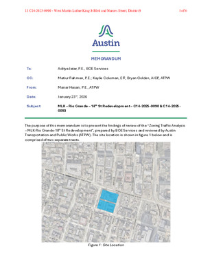
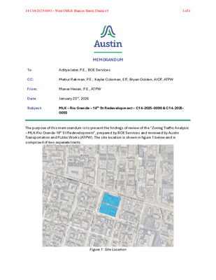
To: CC: From: Date: MEMORANDUM Aditya Jatar, P.E., BOE Services Matiur Rahman, P.E.; Kaylie Coleman, EIT; Bryan Golden, AICP, ATPW Manar Hasan, P.E., ATPW January 23rd, 2026 Subject: MLK – Rio Grande – 18th St Redevelopment – C14-2025-0090 & C14-2025- 0093 The purpose of this memorandum is to present the findings of review of the “Zoning Traffic Analysis – MLK-Rio Grande-18th St Redevelopment”, prepared by BOE Services and reviewed by Austin Transportation and Public Works (ATPW). The site location is shown in figure 1 below and is comprised of two separate tracts. Figure 1: Site Location 13 C14-2025-0090 - West Martin Luther King Jr Blvd and Nueces Street; District 91 of 6 Date: Subject: January 22nd, 2026 MLK – Rio Grande – 18th St Redevelopment ZTA The purpose of this ZTA is to provide support for rezoning from CS, CS-MU, GO, and DMU-CO to DMU-CO. The proposed development is anticipated to remove the existing 17,574 SF of laundry services, 2,584 SF of fast-food without drive thru, 1,232 SF of bakery without drive thru, 49 dwelling units of low-rise multifamily, and 2,333 SF of office to include 32,624 SF of retail and 476 hotel rooms on the north tract, and 287 dwelling units of high-rise multifamily and 35,100 SF of retail on the south tract. Adjacent Roadway Characteristics: The development is proposing two (2) driveways along the alley that runs between the two tracts. The location of these driveways is shown as P1 and P2 in Figure 2 below. Figure 2: Proposed Driveway Locations As indicated on the site location map and the conceptual site plan (Figures 1 and 2), the MLK – Rio Grande – 18th St Redevelopment is bounded by W MLK on the north, Nueces St on the east, 18th St on the south, and Rio Grande St on the west in Austin, TX. To adequately describe the significance of the roadways within the vicinity of the site, a further characterization is provided for each. Average daily traffic estimates for these roadways were collected in November of 2025. The Austin Strategic Mobility Plan (ASMP) catalogs the classifications of these major roadways and documents proposed improvements. W Martin Luther King Jr Blvd: W Martin Luther King Jr Blvd along the site frontage is currently a three-lane Level 3 road in the ASMP, requiring 100 ft of ROW. The ASMP calls for improvements including corridor mobility improvements. Based on traffic …
To: City of Austin Planning Commission Re: Opposition and Request for Postponement of Rezoning Applications • • C14-2025-0090 (West Martin Luther King Jr. Boulevard & Nueces Street) C14-2025-0093 (West 18th Street & Nueces Street) Dear Commissioners, January 25, 2025 I am writing to oppose the rezoning applications for the above cases/addresses. My opposition is a matter of both public health and occupational health and safety. I do not oppose redevelopment of this site in principle. However, rezoning to include residential usage must not not proceed until environmental risks associated with the property’s historic dry-cleaning use are adequately addressed and documented. History of the Jack Brown Cleaners Property The subject property, located at West Martin Luther King Jr. Boulevard and Nueces Street, operated as a dry-cleaning facility for several decades [1950 until at least 2003]. Dry-cleaning operations at the site utilized chemical solvents, including perchloroethylene (PCE), which are now well recognized for their long-term environmental persistence and human health risks. Following the discovery of soil and groundwater contamination, the property enrolled in the Texas Commission on Environmental Quality (TCEQ) Voluntary Cleanup Program (VCP No. 1658) and received a “Final Certificate of Completion” from TCEQ in December 2021. While the “Final Certificate of Completion” reflects regulatory closure under the standards, assumptions, and guidance in effect at that time, it does not determine that the site is appropriate for all future uses, such as residential, which require the highest applicable safety standards. Current Status & Neighborhood Concerns The applicant is now seeking to rezone the properties to allow residential and commercial uses. The applicant’s representative has indicated a desire to build two 400+ feet buildings—one a residential building and a second a hotel building—on this block that includes the former dry- cleaner site. The proposed rezoning represents a significant increase in land-use intensity and introduces long-term residential exposure pathways that were not clearly evaluated by TCEQ or remediated as part of the original remediation. Our concerns are supported by an independent environmental evaluation [see attached Exhibit A] prepared by Brad L. Snow, P.E., P.G., a licensed professional engineer and geologist with more than 40 years of experience in environmental investigation and remediation. 14 C14-2025-0093 - West 18th & Nueces Street; District 91 of 11 Specifically, neighbors are concerned with the following. 1. The completed remediation does not rise to the level necessary to support future residential use [the highest applicable safety standards!!!] particularly …
To: CC: From: Date: MEMORANDUM Aditya Jatar, P.E., BOE Services Matiur Rahman, P.E.; Kaylie Coleman, EIT; Bryan Golden, AICP, ATPW Manar Hasan, P.E., ATPW January 23rd, 2026 Subject: MLK – Rio Grande – 18th St Redevelopment – C14-2025-0090 & C14-2025- 0093 The purpose of this memorandum is to present the findings of review of the “Zoning Traffic Analysis – MLK-Rio Grande-18th St Redevelopment”, prepared by BOE Services and reviewed by Austin Transportation and Public Works (ATPW). The site location is shown in figure 1 below and is comprised of two separate tracts. Figure 1: Site Location 14 C14-2025-0093 - West 18th & Nueces Street; District 91 of 6 Date: Subject: January 22nd, 2026 MLK – Rio Grande – 18th St Redevelopment ZTA The purpose of this ZTA is to provide support for rezoning from CS, CS-MU, GO, and DMU-CO to DMU-CO. The proposed development is anticipated to remove the existing 17,574 SF of laundry services, 2,584 SF of fast-food without drive thru, 1,232 SF of bakery without drive thru, 49 dwelling units of low-rise multifamily, and 2,333 SF of office to include 32,624 SF of retail and 476 hotel rooms on the north tract, and 287 dwelling units of high-rise multifamily and 35,100 SF of retail on the south tract. Adjacent Roadway Characteristics: The development is proposing two (2) driveways along the alley that runs between the two tracts. The location of these driveways is shown as P1 and P2 in Figure 2 below. Figure 2: Proposed Driveway Locations As indicated on the site location map and the conceptual site plan (Figures 1 and 2), the MLK – Rio Grande – 18th St Redevelopment is bounded by W MLK on the north, Nueces St on the east, 18th St on the south, and Rio Grande St on the west in Austin, TX. To adequately describe the significance of the roadways within the vicinity of the site, a further characterization is provided for each. Average daily traffic estimates for these roadways were collected in November of 2025. The Austin Strategic Mobility Plan (ASMP) catalogs the classifications of these major roadways and documents proposed improvements. W Martin Luther King Jr Blvd: W Martin Luther King Jr Blvd along the site frontage is currently a three-lane Level 3 road in the ASMP, requiring 100 ft of ROW. The ASMP calls for improvements including corridor mobility improvements. Based on traffic counts, the 2025 Average …
09 C14-2025-0092 - 2108 and 2110 East 22nd Street; District 1 1 of 4 Catherine and Daniel Tucek Dear Planning Commission: Btackland Neighborhood has always supported growth on the corridors: businesses, restaurants on MLK Jr. Blvd. and Manor Rd. in our Neighborhood Plan. We have and support residential building on E 20th, 21st, 22nd - whether market rate, affordable housing with BCDC's multifamily and SF-3, or condo regimes. and worked with UT to get Grad student residential housing on our west boundary. The lots in question are also zoned residential which Sam Hellman-Mass knew when he purchased it. It's not a "neighborhood benefit" in zoning for us to have: • a commercial office incursion into the housing areas; another restaurant used for 7am-4pm PLUS prep and clean up time before and after AND use for special events in the evenings; Within 7/'0 of a mile - we have 22 other restaurants & bars on Manor Road alone with 7/10 of Este and Bar Toti - not including Sam '.s new restaurant venture in the commercially zoned former Ace Motel. On E. MLK Jr Blvd - Blackland's south boundary - 8 more coffee shops, restaurants and bars. Count them: 32 in Jess than 5 blocks north and south I checked all along MLK to Alexander Street - not one incursion into the interior neighborhood next to residences except apartments and the old United Way). On Manor Road, only apartments and the backyard of the Vortex (fenced off. Just like Enfield in West Austin - everything on the corridors. What I didn't see in West Austin was 32 restaurants/bars/trailers/ ice cream shops on those corridors (not including Lamar to 135}. The planning team said precedent was: an residential apartment complex at Stafford; and the Drenner Group cited to Blackland Neighborhood Association the Blackland Community Development Center's Stewart Conservatory: a single story 1930s' home now zoned MF and about to have affordable Housing tiny homes surrounding it. What we get: • increased traffic all morning/evening plus whenever they want to book private events in the space. I personally believe the new restaurant will be used for frequent evening events. • ore crowded streets and only 8 additional parking spots. The "party room" will compete for the same spaces as Este and Bar Toti. And valet parking - always full - will simply park further into the neighborhood. Trying to have a party on …
13 C14-2025-0090 - West Martin Luther King Jr Blvd and Nueces Street; District 91 of 36 13 C14-2025-0090 - West Martin Luther King Jr Blvd and Nueces Street; District 92 of 36 Eagle Synergistic Optimizing Technologies, LLC Specialized in High Resolution Site Characterization Caroline Reynolds CR Solutions crsolns@icloud.com 512-454-8880 Caroline, Thank you for requesting a proposal for subsurface imaging High Resolution Site Characterization (HRSC) services in Austin, TX. Please find attached Eagle Synergistic’s proposal to help meet your project objectives by optimizing the investigative phase with high-resolution data. We strive to ensure that our client’s goals are not only met but also exceeded. Please let us know if you have any questions or revision requests. Thank you, Janet L Castle, PG, President jcastle@EagleSynergistic.com Eagle Synergistic 751 Pine Ridge Rd #100 Golden, CO 80403 Direct: 720-475-0022 Office: 303-305-7783 www.EagleSynergistic.com Locations Nationwide: CO, TX, CA, GA, PA, IL WOS O: 303-305-7783 | www.EagleSynergistic.com | D: 720-475-0022 13 C14-2025-0090 - West Martin Luther King Jr Blvd and Nueces Street; District 93 of 36 Proposal # 23.109 CR Solutions JACK BROWN CLEANERS 615 W. MLK, JR. BLVD AUSTIN, TEXAS O: 303-305-7783 | www.EagleSynergistic.com | D: 720-475-0022 13 C14-2025-0090 - West Martin Luther King Jr Blvd and Nueces Street; District 94 of 36 Table of Contents OVERVIEW .................................................................................................................................................................... 4 Site Description per Client .......................................................................................................................................... 4 SITE FIGURES .............................................................................................................................................................. 5 PROPOSED POINTS .................................................................................................................................................... 9 TECHNICAL APPROACH AND SCOPE OF WORK .................................................................................................... 10 Scope of Work .......................................................................................................................................................... 10 Site Safety ................................................................................................................................................................ 12 Experience and Past Performance ........................................................................................................................... 12 Capacity to Perform the SOW .................................................................................................................................. 13 HRSC TECHNOLOGY ................................................................................................................................................. 14 Membrane Interface Probe ....................................................................................................................................... 14 CONFIRMATION & CORRELATION (OPTIONAL) ...................................................................................................... 19 1.75” Ground Water Sampler.................................................................................................................................... 19 Project Assumptions ................................................................................................................................................. 20 Insurance .................................................................................................................................................................. 21 Health & Safety Audit and Risk Management Programs .......................................................................................... 21 CLIENT DELIVERABLES AND EXAMPLES ................................................................................................................ 22 3D Modeling and Visualizations................................................................................................................................ 25 Numerous models and views will be supplied as part of the 3D package ................................................................ 27 OTHER HRSC SERVICES .......................................................................................................................................... 28 PRICING ...................................................................................................................................................................... 31 SIGNATURE PAGE ..................................................................................................................................................... 33 THANK YOU ................................................................................................................................................................ 34 O: 303-305-7783 | www.EagleSynergistic.com | D: 720-475-0022 13 C14-2025-0090 - West Martin Luther King Jr Blvd and Nueces Street; District 95 of 36 P a g e | 4 OVERVIEW Eagle Synergistic Optimizing Technologies, LLC is pleased to submit this proposal for High Resolution Site Characterization Subsurface Imaging services to support CR Solutions in achieving your goals. Eagle Synergistic’s team has over 40 …
14 C14-2025-0093 - West 18th & Nueces Street; District 91 of 36 14 C14-2025-0093 - West 18th & Nueces Street; District 92 of 36 Eagle Synergistic Optimizing Technologies, LLC Specialized in High Resolution Site Characterization Caroline Reynolds CR Solutions crsolns@icloud.com 512-454-8880 Caroline, Thank you for requesting a proposal for subsurface imaging High Resolution Site Characterization (HRSC) services in Austin, TX. Please find attached Eagle Synergistic’s proposal to help meet your project objectives by optimizing the investigative phase with high-resolution data. We strive to ensure that our client’s goals are not only met but also exceeded. Please let us know if you have any questions or revision requests. Thank you, Janet L Castle, PG, President jcastle@EagleSynergistic.com Eagle Synergistic 751 Pine Ridge Rd #100 Golden, CO 80403 Direct: 720-475-0022 Office: 303-305-7783 www.EagleSynergistic.com Locations Nationwide: CO, TX, CA, GA, PA, IL WOS O: 303-305-7783 | www.EagleSynergistic.com | D: 720-475-0022 14 C14-2025-0093 - West 18th & Nueces Street; District 93 of 36 Proposal # 23.109 CR Solutions JACK BROWN CLEANERS 615 W. MLK, JR. BLVD AUSTIN, TEXAS O: 303-305-7783 | www.EagleSynergistic.com | D: 720-475-0022 14 C14-2025-0093 - West 18th & Nueces Street; District 94 of 36 Table of Contents OVERVIEW .................................................................................................................................................................... 4 Site Description per Client .......................................................................................................................................... 4 SITE FIGURES .............................................................................................................................................................. 5 PROPOSED POINTS .................................................................................................................................................... 9 TECHNICAL APPROACH AND SCOPE OF WORK .................................................................................................... 10 Scope of Work .......................................................................................................................................................... 10 Site Safety ................................................................................................................................................................ 12 Experience and Past Performance ........................................................................................................................... 12 Capacity to Perform the SOW .................................................................................................................................. 13 HRSC TECHNOLOGY ................................................................................................................................................. 14 Membrane Interface Probe ....................................................................................................................................... 14 CONFIRMATION & CORRELATION (OPTIONAL) ...................................................................................................... 19 1.75” Ground Water Sampler.................................................................................................................................... 19 Project Assumptions ................................................................................................................................................. 20 Insurance .................................................................................................................................................................. 21 Health & Safety Audit and Risk Management Programs .......................................................................................... 21 CLIENT DELIVERABLES AND EXAMPLES ................................................................................................................ 22 3D Modeling and Visualizations................................................................................................................................ 25 Numerous models and views will be supplied as part of the 3D package ................................................................ 27 OTHER HRSC SERVICES .......................................................................................................................................... 28 PRICING ...................................................................................................................................................................... 31 SIGNATURE PAGE ..................................................................................................................................................... 33 THANK YOU ................................................................................................................................................................ 34 O: 303-305-7783 | www.EagleSynergistic.com | D: 720-475-0022 14 C14-2025-0093 - West 18th & Nueces Street; District 95 of 36 P a g e | 4 OVERVIEW Eagle Synergistic Optimizing Technologies, LLC is pleased to submit this proposal for High Resolution Site Characterization Subsurface Imaging services to support CR Solutions in achieving your goals. Eagle Synergistic’s team has over 40 years combined experience in geological, geophysical, logging, subsurface imaging, and 3D modeling aspects. Our business model includes a critical upgrade …
PLANNING COMMISSION MEETING MINUTES Tuesday, January 27, 2026 PLANNING COMMISSION MEETING MINUTES REGULAR MEETING TUESDAY, JANUARY 27, 2026 The Planning Commission convened in a regular on Tuesday, January 27, 2026, at Austin City Hall, Council Chambers, Room 1001, 301 W. Second Street, in Austin, Texas. Chair Woods called the Planning Commission Meeting to order at 6:01 p.m. Commissioners in Attendance: Alice Woods Imad Ahmed Brian Bedrosian Chris Gannon Felicity Maxwell Adam Powell Commissioners in Attendance Remotely: Peter Breton Joshua Hiller Anna Lan Danielle Skidmore Commissioners Absent: Casey Haney Nadia Barrera-Ramirez Ex-Officio Members in Absent: TC Broadnax Jessica Cohen Candace Hunter Richard Mendoza 1 Vacancy on the Dais 1 PLANNING COMMISSION MEETING MINUTES Tuesday, January 27, 2026 PUBLIC COMMUNICATION: GENERAL Philip Wiley – Mobility Oriented Development APPROVAL OF MINUTES 1. Approve the minutes of the Planning Commission regular meeting on Tuesday, January 13, 2026. The minutes from the meeting of Tuesday, January 13, 2026, were approved on the consent agenda on Secretary Maxwell’s motion, Commissioner Powell’s second, on a 10-0 vote. Vice Chair Haney and Commissioner Barrera-Ramirez were absent. 1 vacancy on the dais. PUBLIC HEARINGS 2. Plan Amendment: NPA-2024-0018.01 - 7003, 7005, 7007 Guadalupe Street Rezone; Location: District 4 7003, 7005, 7007 Guadalupe Street, Waller Creek Watershed; Brentwood/Highland Combined (Highland) Neighborhood Planning Area Owner/Applicant: Purple Square One Limited Liability (Lan Chen) Agent: Request: Bowman (Jerome Perales, P.E.) High Density Single Family and Multifamily Residential to Mixed Use land use Staff postponement request to February 10, 2026 Maureen Meredith, 512-974-2695, maureen.meredith@austintexas.gov Austin Planning Staff Rec.: Staff: The motion to approve Staff’s postponement request to February 10, 2026, was approved on the consent agenda on Secretary Maxwell’s motion, Commissioner Powell’s second, on a 10-0 vote. Vice Chair Haney and Commissioner Barrera-Ramirez were absent. 1 vacancy on the dais. 3. Rezoning: Location: C14-2024-0036 - 7003, 7005, 7007 Guadalupe Street Rezone; District 4 7003, 7005, 7007 Guadalupe Street, Waller Creek Watershed; Brentwood/Highland Combined (Highland) Neighborhood Planning Area Owner/Applicant: Purple Square One Limited Liability (Lan Chen) Agent: Request: Bowman (Jerome Perales, P.E.) MF-1-CO-ETOD-DBETOD-NP (Subdistrict 2), SF-6-NP and MF-2-ETOD- DBETOD-NP (Subdistrict 2) to GR-ETOD-DBETOD-NP (Subdistrict 1), increasing the maximum building height from 90 feet to 120 feet through participation in a density bonus program. Staff postponement request to February 10, 2026 Jonathan Tomko, 512-974-1057, jonathan.tomko@austintexas.gov Austin Planning Staff Rec.: Staff: The motion to approve Staff’s postponement request to February 10, 2026, was approved on the consent …
REGULAR MEETING OF THE PLANNING COMMISSION TUESDAY, JANUARY 13, 2026, AT 6 P.M. AUSTIN CITY HALL, COUNCIL CHAMBERS, ROOM 1001 301 WEST 2ND STREET AUSTIN, TEXAS Some members of the Planning Commission may be participating by videoconference. The meeting may be viewed online at: http://www.austintexas.gov/page/watch-atxn-live Public comment will be allowed in-person or remotely via telephone. Speakers may only register to speak on an item once either in-person or remotely and will be allowed up to three minutes to provide their comments. Registration no later than 2 p.m. on the day of the meeting is required for remote participation by telephone. To register to speak remotely, contact Ella Garcia, Staff Liaison, for questions regarding speaker registration at LandUseLiaison@austintexas.gov or by phone at 512- 978-0821. CURRENT COMMISSIONERS: Alice Woods, Chair (District 2) Casey Haney, Vice Chair (Mayor’s Representative) Felicity Maxwell, Secretary (District 5) Imad Ahmed, Parliamentarian (District 6) Anna Lan (Mayor’s Representative) Vacant (Mayor’s Representative) Vacant (District 1) EX-OFFICIO MEMBERS: Nadia Barrera-Ramirez (District 3) Brian Bedrosian (District 4) Adam Powell (District 7) Peter Breton (District 8) Danielle Skidmore (District 9) Joshua Hiller (District 10) Jessica Cohen, Chair of Board of Adjustment TC Broadnax, City Manager EXECUTIVE SESSION (No public discussion) Candace Hunter, A.I.S.D. Board of Trustees Richard Mendoza, Director of Transportation and Public Works The Planning Commission will announce it will go into Executive Session, if necessary, according to Chapter 551 of the Texas Government Code, to receive advice from Legal Counsel on matters specifically listed on the agenda. The Commission may not conduct a closed meeting without the approval of the city attorney. Private Consultation with Attorney – Section 551.071. Staff Liaison: Ella Garcia, 512-978-0821 Attorney: AJ Urteaga, 512-974-2386 Page 1 of 8 AGENDA CALL TO ORDER PUBLIC COMMUNICATION: GENERAL The first four speakers signed up prior to the meeting being called to order will each be allowed a three-minute allotment to address their concerns regarding items not posted on the agenda. APPROVAL OF MINUTES 1. Approve the minutes of the Planning Commission regular meeting on Tuesday, December 16, 2025. PUBLIC HEARINGS 2. Plan Amendment: NPA-2025-0025.03 - Lantana Tract 34; District 8 Location: 7009 West William Cannon Drive, Williamson Creek Watershed; Oak Hill Combined (West Oak Hill) Neighborhood Planning Area Owner/Applicant: Stratus Properties Operating Company Armbrust & Brown, PLLC (Jewels Cain) Agent: Office to Commercial land use Request: Recommended Staff Rec.: Maureen Meredith, 512-974-2695, Staff: maureen.meredith@austintexas.gov Austin Planning 3. Rezoning: Location: …