PLANNING COMMISSION SITE PLAN CONDITIONAL USE PERMIT REVIEW SHEET CASE NUMBER: SPC-2026-0052A PC DATE: April 28, 2026 PROJECT NAME: Girls' School of Austin Conditional Use Permit ADDRESS: 2007 McCall Road COUNCIL DISTRICT: 10 NEIGBORHOOD PLAN: West Austin NP APPLICANT: Girls’ School of Austin AGENT: Thrower Design (A. Ron Thrower) CASE MANAGER: Heather Chaffin Heather.chaffin@austintexas.gov (512) 974-2140 AREA: WATERSHED: WATERSHED ORDINANCE: Comprehensive Watershed Ordinance T.I.A.: 2.31 Acres Johnson Creek (Urban) CAPITOL VIEW: A Neighborhood Traffic Analysis (NTA) has been submitted with this application. N/A PROPOSED DEVELOPMENT: The applicant is requesting a conditional use permit to allow Private Primary Educational Facilities and Private Secondary Educational Facilities, increasing from 150 to 200 students on the property. No improvements are proposed with this application. STAFF RECOMMENDATION: Staff recommends approval of the conditional use permit (CUP), with the condition that any future site development application be required to comply with the NTA Memorandum prepared by Staff, dated April 7, 2026. (Please see Exhibit E – NTA Memorandum). Staff also recommends the following conditions be approved as part of the CUP: 1. Dumpster pick up times to be from 6am to 9pm. 2. Maintenance work will occur from 7am to 9am (except for emergencies). 3. Drop off and pick up times are to be staggered as much as possible. 4. Attendance is limited to 200 students. 5. Use is limited to Private Primary and Private Secondary Educational Use (K-8). SUMMARY COMMENTS ON SITE PLAN: Land Use: The subject property is located on the south side of Windsor Road and the east side of McCall Road. The property is zoned SF-3-NP, and the majority of the site is currently developed with the Girls’ School of Austin (“the School”), which includes Private Primary Educational Facilities and Private Secondary Educational Facilities land uses. The remainder of the property is a former single family lot at 15 SPC-2026-0052A - Girls' School of Austin Conditional Use Permit; District 101 of 63 Girls' School of Austin Conditional Use Permit SPC-2026-0052A 2 1913 McCall Road that was acquired by the School. Properties to the north, south, west and east of the property are also zoned SF-3-NP and are developed with single family residential land uses. (Please see Exhibits A and B – Site Location Map and Aerial Exhibit). Environmental: The site is located in the Johnson Creek Watershed and subject to current watershed regulations. Transportation: Data was submitted by the applicant for a …
Please visit our team’s new website for information on dedicated case management! PER CITY ORDINANCE: All individuals scheduling or accepting a meeting invitation with a City Official are requested to provide responses to the questions at the following link: DSD Visitor Log. Please note that all information provided is subject to public disclosure via DSD’s open data portal. For more information please visit: City of Austin Ordinance 2016-0922-005 | City Clerk’s website | City Clerk’s FAQ’s From: Emilio Ruiz Gudino <emilioruizgudinoa@gmail.com> Sent: Tuesday, November 12, 2024 10:25 PM To: Sapuppo, Chris <Chris.Sapuppo@austintexas.gov> Subject: CASE NUMBER SP-2024-0381C.SH You don't often get email from emilioruizgudinoa@gmail.com. Learn why this is important External Email - Exercise Caution Hello, good evening. I was wondering on this case number if you had any pictures on what this project would look like? Also, what I would be able to ask for since they are building this project near 500 feet from where I live? CAUTION: This is an EXTERNAL email. Please use caution when clicking links or opening attachments. If you believe this to be a malicious or phishing email, please report it using the "Report Message" button in Outlook. For any additional questions or concerns, contact CSIRT at "cybersecurity@austintexas.gov". CAUTION: This is an EXTERNAL email. Please use caution when clicking links or opening attachments. If you believe this to be a malicious or phishing email, please report it using the "Report Message" button in Outlook. For any additional questions or concerns, contact CSIRT at "cybersecurity@austintexas.gov". CAUTION: This is an EXTERNAL email. Please use caution when clicking links or opening attachments. If you believe this to be a malicious or phishing email, please report it using the "Report 5 16 SP-2024-0381C.SH - Rundberg Multifamily; District 467 of 67
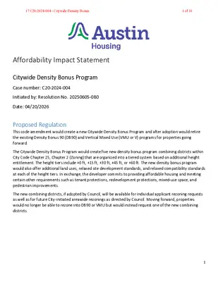
Affordability Impact Statement Citywide Density Bonus Program Case number: C20-2024-004 Initiated by: Resolution No. 20250605-080 Date: 04/20/2026 Proposed Regulation This code amendment would create a new Citywide Density Bonus Program and after adoption would retire the existing Density Bonus 90 (DB90) and Vertical Mixed Use (VMU or V) programs for properties going forward. The Citywide Density Bonus Program would create five new density bonus program combining districts within City Code Chapter 25, Chapter 2 (Zoning) that are organized into a tiered system based on additional height entitlement. The height tiers include +0 ft, +15 ft, +30 ft, +45 ft, or +60 ft. The new density bonus program would also offer additional land uses, relaxed site development standards, and relaxed compatibility standards at each of the height tiers. In exchange, the developer commits to providing affordable housing and meeting certain other requirements such as tenant protections, redevelopment protections, mixed-use space, and pedestrian improvements. The new combining districts, if adopted by Council, will be available for individual applicant rezoning requests as well as for future City-initiated areawide rezonings as directed by Council. Moving forward, properties would no longer be able to rezone into DB90 or VMU but would instead request one of the new combining districts. 1 17 C20-2024-004 - Citywide Density Bonus1 of 10 Figure 1. Comparison of Proposed Citywide Density Bonus Tiers. (Source: Austin Planning) Tier Combining District Name Comparable Existing Program No Additional Height Citywide Density Bonus Program Base (-DBC) Vertical Mixed Use (V) +15’ +30’ +45’ +60’ Citywide Density Bonus Program 15’ (-DBC15) Citywide Density Bonus Program 30’ (-DBC30) Citywide Density Bonus Program 45’ (-DBC45) Citywide Density Bonus Program 60’ (-DBC60) N/A DB90, DBETOD Subdistrict 2 N/A DBETOD Subdistrict 1 Land Use/Zoning Impacts on Housing Costs The proposed changes would have positive impacts on housing costs from land use/zoning: • • • SB 840 from the 2025 Regular Session of the Texas Legislature established new development entitlements in certain areas. These greater by-right entitlements have made Austin’s density bonus programs less attractive, or perhaps obsolete in the case of V. Density bonus programs are a critical tool for gaining more income-restricted housing through on-site affordable units and fee-in-lieu (FIL) going to the City’s Housing Trust Fund. Density bonus programs have been used for over 20%1 of the over 25,000 income-restricted homes recorded as completed or under construction in the City’s Affordable Housing Inventory data, and 80% of the …
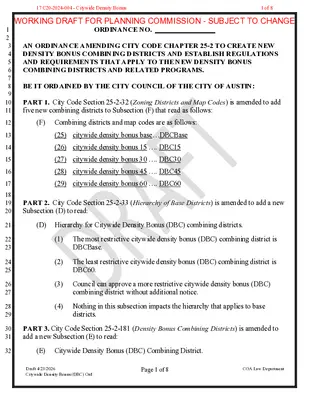
1 2 3 4 5 6 7 8 9 10 11 12 13 14 15 16 17 18 19 20 21 22 23 24 25 26 27 28 29 30 31 32 ORDINANCE NO. _________________ AN ORDINANCE AMENDING CITY CODE CHAPTER 25-2 TO CREATE NEW DENSITY BONUS COMBINING DISTRICTS AND ESTABLISH REGULATIONS AND REQUIREMENTS THAT APPLY TO THE NEW DENSITY BONUS COMBINING DISTRICTS AND RELATED PROGRAMS. BE IT ORDAINED BY THE CITY COUNCIL OF THE CITY OF AUSTIN: PART 1. City Code Section 25-2-32 (Zoning Districts and Map Codes) is amended to add five new combining districts to Subsection (F) that read as follows: (F) Combining districts and map codes are as follows: (25) citywide density bonus base…DBCBase (26) citywide density bonus 15 …. DBC15 (27) citywide density bonus 30 …. DBC30 (28) citywide density bonus 45 …. DBC45 (29) citywide density bonus 60 …. DBC60 PART 2. City Code Section 25-2-33 (Hierarchy of Base Districts) is amended to add a new Subsection (D) to read: (D) Hierarchy for Citywide Density Bonus (DBC) combining districts. (1) (2) (3) The most restrictive citywide density bonus (DBC) combining district is DBCBase. The least restrictive citywide density bonus (DBC) combining district is DBC60. Council can approve a more restrictive citywide density bonus (DBC) combining district without additional notice. (4) Nothing in this subsection impacts the hierarchy that applies to base districts. PART 3. City Code Section 25-2-181 (Density Bonus Combining Districts) is amended to add a new Subsection (E) to read: (E) Citywide Density Bonus (DBC) Combining District. Draft 4/23/2026 Citywide Density Bonus (DBC) Ord Page 1 of 8 COA Law Department WORKING DRAFT FOR PLANNING COMMISSION - SUBJECT TO CHANGE17 C20-2024-004 - Citywide Density Bonus1 of 8 33 34 35 36 37 38 39 40 41 42 43 44 45 46 47 48 49 50 51 52 53 54 55 56 57 58 59 60 61 62 63 64 65 66 67 68 69 (1) A reference to citywide density bonus (DBC) combining district in Title 25 (Land Development) is the collective reference for two or more of the combining districts described by this subsection. (2) DBC combining district authorizes a particular site to participate in a voluntary density bonus or incentive program that provides modifications to site development regulations or other regulatory-related benefits in exchange for community benefits. Generally, lower intensity DBC combining districts are compatible with most eligible commercial zones; …
Citywide Density Bonus Program Planning Commission Hearing | April 28, 2026 Agenda ▪ Background ▪ Citywide Density Bonus Program Staff Proposal ▪ Next Steps Source: City of Austin 2 Background Austin's Affordability Challenges and Needs ▪ Austin has seen population growth over recent decades, and housing production has not kept up with this growth, making it more difficult for people to find affordable housing. Affordable housing is a priority for the City. ▪ The Strategic Housing Blueprint (2017) calls for various tools, including: ▪ Public subsidies and grants ▪ Public-private partnerships ▪ Fee waivers ▪ Tax incentives ▪ Density bonuses ▪ The greatest need is at and below 50% MFI ($66,900 for a four-person household). Source: City of Austin 4 Density Bonuses And Economic Context ▪ A density bonus allows a developer to build more in exchange for a community benefit, usually affordable housing. They are market- based, voluntary tools. They depend on current economic conditions for success. ▪ Density bonuses tend to be more effective for units affordable between 50%-80% MFI. ▪ Austin’s real estate and construction market is in a different place than it was previously, with costs and uncertainty rising. ▪ Recent changes to state law like Senate Bill 840 (SB 840) encourage more market-rate housing, but impact density bonus effectiveness. Source: City of Austin 5 City Council's Direction Austin City Council directed staff to create a new Citywide Density Bonus Program with a tiered structure, offering a range of additional heights in exchange for income- restricted housing, that also considers: ▪ Additional Heights: Consider tiered options that are more or less than 30’ ▪ Market-Feasible Affordability: Ensure requirements reflect current market conditions ▪ Community Benefits: Provide benefits beyond affordable housing ▪ Compatibility Rules: Update regulations to allow for more housing ▪ Redevelopment Requirements: Consider one-to-one replacement for demolished affordable units in new developments Council also asked us to update or align existing programs including DB90, VMU, and DBETOD with the new program. Source: City of Austin 6 Citywide Density Bonus Program Goals ▪ Encourage creation of new affordable housing without additional City subsidy. ▪ Provide more density bonus options that can be tailored to different neighborhood contexts across Austin. ▪ Help make density bonus requirements more consistent and transparent for City staff, property owners, builders, and the community. ▪ Respond to the implications of SB 840 that impact where and how housing can be built by-right. …
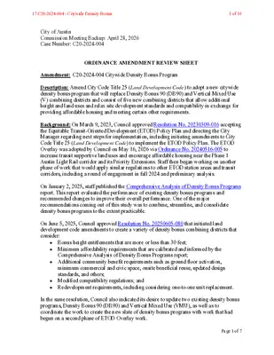
City of Austin Commission Meeting Backup: April 28, 2026 Case Number: C20-2024-004 ORDINANCE AMENDMENT REVIEW SHEET Amendment: C20-2024-004 Citywide Density Bonus Program Description: Amend City Code Title 25 (Land Development Code) to adopt a new citywide density bonus program that will replace Density Bonus 90 (DB90) and Vertical Mixed Use (V) combining districts and consist of five new combining districts that allow additional height and land uses and relax site development standards and compatibility in exchange for providing affordable housing and meeting certain other requirements. Background: On March 9, 2023, Council approved Resolution No. 20230309-016 accepting the Equitable Transit-Oriented Development (ETOD) Policy Plan and directing the City Manager regarding next steps for implementation, including initiating amendments to City Code Title 25 (Land Development Code) to implement the ETOD Policy Plan. The ETOD Overlay was adopted by Council on May 16, 2026 via Ordinance No. 20240516-005 to increase transit supportive land uses and encourage affordable housing near the Phase 1 Austin Light Rail corridor and its Priority Extensions. Staff then began working on another phase of work that would apply similar regulations to other ETOD station areas and transit corridors, including a round of engagement in fall 2024 and preliminary analysis. On January 2, 2025, staff published the Comprehensive Analysis of Density Bonus Programs report. This report evaluated the performance of existing density bonus programs and recommended changes to improve their overall performance. One of the major recommendations coming out of this study was to combine, streamline, and consolidate density bonus programs to the extent practicable. On June 5, 2025, Council approved Resolution No. 20250605-080 that initiated land development code amendments to create a variety of density bonus combining districts that consider: • Bonus height entitlements that are more or less than 30 feet; • Minimum affordability requirements that are calibrated and informed by the Comprehensive Analysis of Density Bonus Programs report; • Additional community benefit requirements such as ground floor activation, minimum commercial and civic space, onsite beneficial reuse, updated design standards, and others; • Modified compatibility regulations; and • Redevelopment requirements, including considering one-to-one unit replacement. In the same resolution, Council also indicated its desire to update two existing density bonus programs, Density Bonus 90 (DB90) and Vertical Mixed Use (VMU), as well as to coordinate the work to create the new slate of density bonus programs with work that had begun on a second phase of ETOD Overlay …
Am. Commissioner Proposed Amendment Justification Woods Vote Gannon Vote Bedrosian Vote Hiller Vote Breton Vote Allow fee in lieu payments as an option for rental housing developments. Fee in lieu funds generated shall be a) restricted for use as RDHA or OHDA funding, and b) geographically prioritized to affordable developments within 1.5 mi of the originating density bonus development. If no eligible Rental Housing Development Assistanct (RHDA) or Ownership Housing Development Assistance (OHDA)-funded projects exist to accept the funds within 3 years of fee-in-lieu payment, fee in-lieu funds shall revert to general RHDA/OHDA funding for any citywide project recieving this funding. Exempt projects with 16 or fewer dwelling units, or lots zoned MF-3 or more restrictive, from compatibility standards 1 Woods 2 Gannon 3 Breton Use a scaling factor of +25ft, +50ft, +75ft. 4 Breton / Woods Add +100 and +125 tiers General Recommendation: Create a "ground floor menu", based on the structure of the urban design standards menu in the proposed Downtown Density Bonus update, to offset the 75% ground-floor street frontage requirement and add flexibility for projects without having to pursue a site-specific waiver. Ensure that requirements are right-sized for projects with varying levels of street frontage. For onsite affordable units, allow developers to round down a fractional amount under 1/2, rather than rounding up. Anything 1/2 or above should continue to be rounded up. 5 Breton/Bedrosian 6 Breton/Bedrosian Density bonus affordable units have demonstrated compliance challenges in Austin, including vacancies and units not leased to income-qualifying tenants, limiting actual affordability outcomes. Directing fee in lieu payments to RHDA or OHDA programs instead funds deeply affordable housing structures that carry long-term federal compliance requirements and stronger affordability accountability. These programs also address a critical gap financing need for developments targeting 30% AMI units and with larger affordable unit counts, which the city currently lacks capacity to fund directly. Geographic prioritization ensures reinvestment within the same neighborhoods generating density bonuses, supporting equitable distribution of affordable housing across the city. Temporal prioritization ensures funds are spent in a timely manner to best meet our affordability goals without depreciating significantly. This mirrors existing exemptions for the citywide compatibility regulations and is intended to encourage smaller lot development, and smaller multifamily structures, which would be more impacted by a compatibility setback. This exemption could also be applied to small lots regardless of unit count. This would ensure that the lowest tier would …
Affordability Impact Statement Transit System Projects Amendments Case number: C20-2026-003 Initiated by: Resolution No. 20211029-003 Date: 4/2/2026 Proposed Regulation The proposed amendment changes the Transit System Ordinance (20221115-048) adopted in 2022 to add additional streamlining elements with a focus on project-specific technical regulation. The local justification of this ordinance is to streamline the review process for Light Rail to help the efficiency of the funds and resources devoted to the effort. The ordinance streamlines local regulations and criteria for the Light Rail project, while not changing the intended outcomes of these regulations and criteria. This project-specific ordinance only affects the departments that perform reviews and the affected department’s utilities. Watershed Protection, Development Services, Austin Water, Austin Energy, Transportation Public Works, and Planning have been directly involved with the drafting of their sections of the revised ordinance, ensuring the changes will streamline reviews, especially that of variances, and reduce review time/effort. Proposed changes include: • There are technical spacing requirements for utilities - project specific/constrained criteria, project specific criteria for water quality. • Allowing for the Limits of Construction within a site plan to be non-contiguous. • Reviewing Heritage Trees administratively rather than by Commission (borrowed from school district ordinance). • Revoke an unused 4th street ordinance that limited utilities. • Requiring that the construction of the light rail itself comply with the Project Connect Design Criteria (PCDC) for sidewalk standards. 1 18 C20-2026-003 - Amendments Related to Transit System Projects1 of 2 Land Use/Zoning Impacts on Housing Costs The proposed changes would have neutral impacts on housing costs. Impact on Development Cost The proposed changes would have neutral impacts on development costs. Impact on Affordable Housing The proposed changes would have neutral impacts on affordable housing: Overall Impact The proposed changes would have a neutral overall impact: • The proposed amendment applies only to Transit System Projects and does not alter the intended outcomes of existing criteria or regulations. Its primary effect is to streamline project‑specific technical reviews for the Light Rail program, reducing staff time and administrative effort while aligning with citywide goals for regulatory efficiency and implementation of Project Connect. • While streamlining transit projects can indirectly support broader affordability goals by improving access to reliable transportation, this amendment does not directly affect housing development, costs, or affordability. Other Policy Considerations • None at this time. Manager’s Signature ______________________________________________________________ 2 18 C20-2026-003 - Amendments Related to Transit System …
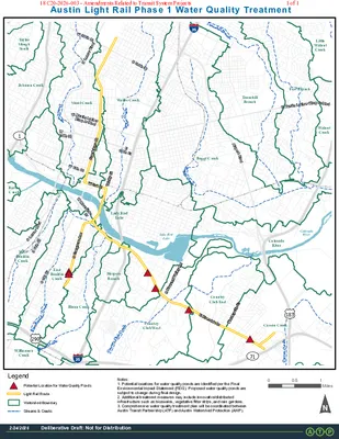
S1StStEMartinLutherKingJrBlvdE38ThStSLamarBlvdWMartinLutherKingJrBlvdNLamarBlvdW38ThStAirportBlvdW6ThStW15ThStS6ThStWRiversideDrE15ThStCarsonCreekBlunnCreekEastBouldinCreekShoalCreekCountryClubCreekWallerCreekTannehillBranchBoggyCreek7112901833535CountryClub EastBlunn CreekWalnutCreekEastBouldinCreekCountryClub WestWilliamsonCreekTannehillBranchColoradoRiverBartonCreekShoal CreekFort BranchHarpersBranchJohnson CreekWaller CreekTaylorSloughSouthCarson CreekLittleWalnutCreekLady BirdLakeWestBouldinCreekBoggy CreekDeliberative Draft: Not for Distribution2/24/202600.51MilesAustin Light Rail Phase 1 Water Quality TreatmentWatershed BoundaryLight Rail RoutePotential Location for Water Quality PondsLegendStreams & CreeksDeliberative Draft: Not for Distribution2/24/2026E Riverside DrS Congress AveLake BirdLakeColoradoRiverNotes:1. Potential locations for water quality ponds are identified per the FinalEnvironmental Impact Statement (FEIS). Proposed water quality ponds aresubject to change during final design.2. Additional treatment measures may include innovative/distributedinfrastructure such as bioswales, vegetative filter strips, and rain gardens.3. Comprehensive water quality treatment plan will be coordinated betweenAustin Transit Partnership (ATP) and Austin Watershed Protection (AWP).Trinity StS Pleasant Valley RdMontopolis DrGuadalupe StW 3rd St18 C20-2026-003 - Amendments Related to Transit System Projects1 of 1
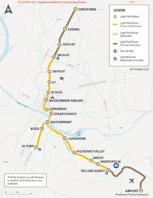
PART 1. On March 9, 2000, City Council adopted Ordinance No. 000309-114 to designate a future rail corridor consisting of the Fourth Street right-of-way between Interstate 35 and Rio Grande Street, and West Third Street right-of-way from Shoal Creek to North Lamar Boulevard. The rail itself was not approved. This ordinance repeals Ordinance No. 000309-114. PART 2. On November 15, 2022, City Council adopted Ordinance No. 20221115-048 (the “Original Ordinance”), approving the Transit System Project Regulations to facilitate the construction of Project Connect, the City’s high-capacity transit system expansion. PART 3. The attached exhibits are incorporated into this ordinance in their entirety as though set fully in the text of this ordinance. The exhibits are as follows: Exhibit A and A-1: Transit System Project Map Exhibit C: Preliminary Water Quality Treatment Map PART 4. This ordinance and the attached exhibits amend the Original Ordinance as amended for the Transit System Project Regulations, modifying conditions and replacing any likewise named or identified exhibits in the Original Ordinance as amended. Development of and uses for the Transit System Project shall conform to the limitations and conditions set forth in this ordinance and in the attached exhibits. If this ordinance and the attached exhibits conflict, this ordinance controls. Except as otherwise specifically provided by this ordinance, all other rules, regulations and ordinances of the City of Austin (“City”) apply to a Transit System Project. PART 5. Definitions. (A) Austin Light Rail means the light rail system generally depicted on Exhibit A-1 with any related appurtenances funded by a public entity. (B) Offsite Treatment Area may include adjacent rights-of-way and single-family subdivisions. (C) Unless otherwise specifically defined, all terms in this ordinance shall have the meaning established in City Code Title 25 (Land Development). 1 2 3 4 5 6 7 8 9 10 11 12 13 14 15 16 17 18 19 20 21 22 23 24 25 26 27 28 29 30 31 32 33 34 35 36 37 38 39 40 Draft 4/24/2026 Page 1 of 7 COA Law Department WORKING DRAFT. SUBJECT TO CHANGE.18 C20-2026-003 - Amendments Related to Transit System Projects1 of 7 41 42 43 44 45 46 47 48 49 50 51 52 53 54 55 56 57 58 59 60 61 62 63 64 65 66 67 68 69 70 71 72 73 74 75 76 77 78 79 80 81 PART 6. Code Modifications. The …
. RECOMMENDATION TO COUNCIL Environmental Commission Recommendation 20260415-002: City Code Title 25 (Land Development) Ordinance No. 20221115- 048 Amendment for Project Connect WHEREAS, the Environmental Commission was given a presentation on the updates for the Austin Light Rail plan; and WHEREAS, the City of Austin and Austin Transit Partnership seek to amend City Code Title 25 (Land Development) and Ordinance No. 20221115-048 to modify development review processes, methods to demonstrate water quality compliance, street design, and utility infrastructure design for the design and construction of certain transit system projects and related transit system infrastructure; and WHEREAS, Austin Transit Partnership and Austin Project Connect want to: 1. Modify site plan requirements to accommodate permitting tools for the light rail permitting process. 2. Rescind utility ordinance from 2000. 3. Establish back-of-curb streetscape standards for light rail. 4. Establish a water quality compliance program for light rail. 5. Establish administrative review of heritage trees for Transit System Projects. 6. Incorporate administrative rule modifications that address constrained right of way conditions where compliance will be challenging and ensure consistency in expiration of site plan components. NOW, THEREFORE, BE IT RESOLVED, that the Environmental Commission recommends the proposed amendments to Austin City Council with the following additions: • Only native (no adaptive) plants, including trees, will be used. • To promote insect and other pollinator survival, rain gardens and other green spaces in the Right of Way will never be mowed, but periodic efforts to remove non-native, invasive species will be made. To promote the survival of insects and amphibians, fallen leaves from street trees will not be blown, but may be raked around the circumference of the tree and/or left in green space. • 18 C20-2026-003 - Amendments Related to Transit System Projects1 of 2 . • Deny administrative waiver for heritage trees, maintaining the current code standards. If the waiver is granted, then every effort will be made to leave heritage trees in their current locations, followed by transplanting them, rather than cutting them down. • Staff, ATP, APC, and relevant stakeholders will present updates to this Commission regularly as they become apparent. • Clearly define “end of project” in the ordinance. • Any reimbursement for exceeding water regulatory requirements be limited to a specifically defined formula, as defined by the City. Date of Approval: April 15, 2026 Motioned By: Secretary Qureshi Seconded By: Commissioner Sullivan Vote: For: 9-0 Chair Krueger, Vice Chair …
. RECOMMENDATION TO COUNCIL Environmental Commission Recommendation 20260415-002: City Code Title 25 (Land Development) Ordinance No. 20221115- 048 Amendment for Project Connect WHEREAS, the Environmental Commission was given a presentation on the updates for the Austin Light Rail plan; and WHEREAS, the City of Austin and Austin Transit Partnership seek to amend City Code Title 25 (Land Development) and Ordinance No. 20221115-048 to modify development review processes, methods to demonstrate water quality compliance, street design, and utility infrastructure design for the design and construction of certain transit system projects and related transit system infrastructure; and WHEREAS, Austin Transit Partnership and Austin Project Connect want to: 1. Modify site plan requirements to accommodate permitting tools for the light rail permitting process. 2. Rescind utility ordinance from 2000. 3. Establish back-of-curb streetscape standards for light rail. 4. Establish a water quality compliance program for light rail. 5. Establish administrative review of heritage trees for Transit System Projects. 6. Incorporate administrative rule modifications that address constrained right of way conditions where compliance will be challenging and ensure consistency in expiration of site plan components. NOW, THEREFORE, BE IT RESOLVED, that the Environmental Commission recommends the proposed amendments to Austin City Council with the following additions: • Only native (no adaptive) plants, including trees, will be used. • To promote insect and other pollinator survival, rain gardens and other green spaces in the Right of Way will never be mowed, but periodic efforts to remove non-native, invasive species will be made. To promote the survival of insects and amphibians, fallen leaves from street trees will not be blown, but may be raked around the circumference of the tree and/or left in green space. • 18 C20-2026-003 - Amendments Related to Transit System Projects1 of 2 . • Deny administrative waiver for heritage trees, maintaining the current code standards. If the waiver is granted, then every effort will be made to leave heritage trees in their current locations, followed by transplanting them, rather than cutting them down. • Staff, ATP, APC, and relevant stakeholders will present updates to this Commission regularly as they become apparent. • Clearly define “end of project” in the ordinance. • Any reimbursement for exceeding water regulatory requirements be limited to a specifically defined formula, as defined by the City. Date of Approval: April 15, 2026 Motioned By: Secretary Qureshi Seconded By: Commissioner Sullivan Vote: For: 9-0 Chair Krueger, Vice Chair …
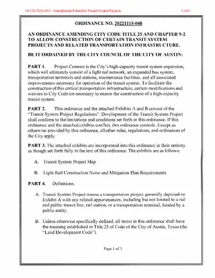
ORDINANCE NO. 20221115-048 AN ORDINANCE AMENDING CITY CODE TITLE 25 AND CHAPTER 9-2 TO ALLOW CONSTRUCTION OF CERTAIN TRANSIT SYSTEM PROJECTS AND RELATED TRANSPORTATION INFRASTRUCTURE. BE IT ORDAINED BY THE CITY COUNCIL OF THE CITY OF AUSTIN: Project Connect is the City's high-capacity transit system expansion, PART 1. which will ultimately consist of a light rail network, an expanded bus system, transportation terminals and stations, maintenance facilities, and all associated improvements necessary for operation of the transit system. To facilitate the construction ofthis critical transportation infrastructure, certain modifications and waivers to City Code are necessary to ensure the construction of a high-capacity transit system. This ordinance and the attached Exhibits A and B consist of the PART 2. "Transit System Project Regulations". Development ofthe Transit System Project shall conform to the limitations and conditions set forth in this ordinance. If this ordinance and the attached exhibits conflict, this ordinance controls. Except as otherwise provided by this ordinance, all other rules, regulations, and ordinances of the City apply. PART 3. The attached exhibits are incorporated into this ordinance in their entirety as though set forth fully in the text of this ordinance. The exhibits are as follows: A. Transit System Project Map B. Light Rail Construction Noise and Mitigation Plan Requirements PART 4. Definitions. A. Transit System Project means a transportation project generally depicted on Exhibit A with any related appurtenances, including but not limited to a rail and public transit line, rail station, or a transportation terminal, funded by a public entity. B. Unless otherwise specifically defined, all terms in this ordinance shall have the meaning established in Title 25 of Code of the City of Austin, Texas (the .,Land Development Code"). Page 1 0f 3 18 C20-2026-003 - Amendments Related to Transit System Projects1 of 6 A Transit System Project for light rail lines or any associated PART 5. infrastructure necessary to construct the light rail lines must comply with a noise and mitigation plan approved by the City that meets the requirements listed in Exhibit B. To the extent there is a conflict with Chapter 9-2 (Noise and Amplified Soundj, the approved noise and mitigation Plan will control. PART 6. Transit System Uses A. The use of a site for a traction powered substation is a Local Utility Service use as described in City Code Section 25-2-6(28). B. The use of a site for the provision of maintenance, …
Transit System Projects Ordinance Amendment Austin Project Connect | April 28, 2026 Transit System Projects Ordinance Response to: Resolution No. 20211029-003 which directed staff to: • Review City Code, criteria manuals, and permitting procedures to identify impediments to the design, construction, implementation, and operation of Project Connect • Develop new regulations and procedures to address those impediments Foundational ordinance approved by Council on Nov. 15, 2022 Established home for Transit System Project regulations Modified permitting tools to accommodate Austin Light Rail Anticipated additional impediments would be identified as project progressed Amendments address these issues and support the project as it enters final design 2 Components of this Ordinance 1. Site Plan Modification 2. Removal of Outdated Utility Policy 3. Austin Light Rail Streetscape Standards 4. Austin Light Rail Water Quality Compliance Program 5. Administrative Review of Heritage Trees 6. Administrative Rule Modifications 3 1. Site Plan Modifications To facilitate the permitting process for Austin Light Rail site plans will be allowed to have non-contiguous limits of construction (LOC). Refresher: Site Plan Layers Tool Modified from Fast Tracks tool. Allows construction to begin on permitted layers while future layers in design. Provides variety of options for efficient permitting and scheduling of project. 4 2. Removal of Outdated Utility Policy In 2000, utilities policy was passed in preparation for a potential future light rail system with an earlier alignment. This policy does not support the current Austin Light Rail alignment. Because this policy is obsolete and to prevent confusion, a recission is being issued. 5 SDf 3. Light Rail Streetscape Standards Project Connect Design Criteria Purpose: Contain back-of-curb streetscape standards for Austin Light Rail The Transportation Criteria Manual (TCM) acknowledges that tailored standards for Project Connect may be needed to align with highly localized contextual design. Provide a consistent design for pedestrian and bicycle facilities, street tree and furniture zones, and associated setbacks and buffers Identify priorities based on the character and needs of each segment along the light rail alignment Respond to constrained and unique conditions Reduce the need for waivers and align adjacent development with the Austin Light Rail design 6 3. Light Rail Streetscape Standards Illustrates typical street cross sections that will be built in the ROW (often constrained) by the Light Rail project In most cases, the …
Transit System Projects Ordinance Amendment Austin Project Connect | April 28, 2026 Transit System Projects Ordinance Response to: Resolution No. 20211029-003 which directed staff to: • Review City Code, criteria manuals, and permitting procedures to identify impediments to the design, construction, implementation, and operation of Project Connect • Develop new regulations and procedures to address those impediments Foundational ordinance approved by Council on Nov. 15, 2022 Established home for Transit System Project regulations Modified permitting tools to accommodate Austin Light Rail Anticipated additional impediments would be identified as project progressed Amendments address these issues and support the project as it enters final design 2 Components of this Ordinance 1. Site Plan Modification 2. Removal of Outdated Utility Policy 3. Austin Light Rail Streetscape Standards 4. Austin Light Rail Water Quality Compliance Program 5. Administrative Review of Heritage Trees 6. Administrative Rule Modifications 3 1. Site Plan Modifications To facilitate the permitting process for Austin Light Rail site plans will be allowed to have non-contiguous limits of construction (LOC). Refresher: Site Plan Layers Tool Modified from Fast Tracks tool. Allows construction to begin on permitted layers while future layers in design. Provides variety of options for efficient permitting and scheduling of project. 4 2. Removal of Outdated Utility Policy In 2000, utilities policy was passed in preparation for a potential future light rail system with an earlier alignment. This policy does not support the current Austin Light Rail alignment. Because this policy is obsolete and to prevent confusion, a recission is being issued. 5 SDf 3. Light Rail Streetscape Standards Project Connect Design Criteria Purpose: Contain back-of-curb streetscape standards for Austin Light Rail The Transportation Criteria Manual (TCM) acknowledges that tailored standards for Project Connect may be needed to align with highly localized contextual design. Provide a consistent design for pedestrian and bicycle facilities, street tree and furniture zones, and associated setbacks and buffers Identify priorities based on the character and needs of each segment along the light rail alignment Respond to constrained and unique conditions Reduce the need for waivers and align adjacent development with the Austin Light Rail design 6 3. Light Rail Streetscape Standards Illustrates typical street cross sections that will be built in the ROW (often constrained) by the Light Rail project In most cases, the …
PLANNING COMMISSION MEETING MINUTES Tuesday, April 14, 2026 PLANNING COMMISSION MEETING MINUTES REGULAR MEETING TUESDAY, APRIL 14, 2026 The Planning Commission convened in a regular on Tuesday, April 14, 2026, at Austin City Hall, Boards and Commissions, Room 1101, 301 W. Second Street, in Austin, Texas. Chair Woods called the Planning Commission Meeting to order at 6:03 p.m. Commissioners in Attendance: Alice Woods Felicity Maxwell Brian Bedrosian Chris Gannon Joshua Hiller Casey Haney Peter Breton Adam Powell Imad Ahmed Commissioners in Attendance Remotely: Nadia Barrera-Ramirez Anna Lan Ex-Officio Members in Attendance: Danielle Skidmore Ex-Officio Members Absent: Jessica Cohen TC Broadnax Candace Hunter Richard Mendoza 1 Vacancy on the Dais 1 PLANNING COMMISSION MEETING MINUTES Tuesday, April 14, 2026 PUBLIC COMMUNICATION: GENERAL None present. APPROVAL OF MINUTES 1. Approve the minutes of the Planning Commission regular meeting on Tuesday, March 31, 2026. The minutes from the meeting of Tuesday, March 31, were approved on the consent agenda on Vice Chair Haney’s motion, Commissioner Breton’s second, on an 11-0 vote. Commissioner Skidmore was absent. 1 vacancy on the dais. PUBLIC HEARINGS 2. Plan Amendment: NPA-2025-0030.01 - Ben White; District 5 Location: 2217 West Ben White Boulevard Service Road Eastbound, Williamson Creek Watershed; South Austin Combined (Westgate) Neighborhood Planning Area Owner/Applicant: RPS Family Enterprises, LP (Robert P. Stern) Agent: Request: Staff Rec.: Staff: Keepers Land Planning (Ricca Keepers) Neighborhood Node to Mixed-Use Activity HUB/Corridor Recommended Maureen Meredith, 512-974-2695, maureen.meredith@austintexas.gov Austin Planning The motion to approve the Applicant’s postponement request to May 12, 2026, was approved on the consent agenda on Vice Chair Haney’s motion, Commissioner Breton’s second, on an 11-0 vote. Commissioner Skidmore was absent. 1 vacancy on the dais. 3. Rezoning: Location: C14-2025-0104 - Ben White; District 5 2217 West Ben White Boulevard Service Road Eastbound, Williamson Creek Watershed; South Austin Combined (Westgate) Neighborhood Planning Area Owner/Applicant: RPS Family Enterprises, LP (Robert P. Stern) Agent: Request: Staff Rec.: Staff: Keepers Land Planning (Ricca Keepers) CS-NP to CS-1-NP Staff recommends CS-1-CO-NP Nancy Estrada, 512-974-7617, nancy.estrada@austintexas.gov Austin Planning The motion to approve the Applicant’s postponement request to May 12, 2026, was approved on the consent agenda on Vice Chair Haney’s motion, Commissioner Breton’s second, on an 11-0 vote. Commissioner Skidmore was absent. 1 vacancy on the dais. 2 PLANNING COMMISSION MEETING MINUTES Tuesday, April 14, 2026 4. Plan Amendment: NPA-2025-0031.01 - 8701 N Mopac Rezoning; District 10 Location: 8701 North Mopac Expressway Service Road …
City of Austin Austin Planning 6310 Wilhelmina Delco Drive, Austin, TX 78752 P.O. Box 1088, Austin, TX 78767-1088 (512) 974-2000 ♦ h ttp s:/ / w w w.au st in tex a s .g ov / d epa r tm e n t/ plan n in g - de part men t MEMORANDUM TO: Chair & Planning Commission Members FROM: Maureen Meredith, Senior Planner, Long-Range Planning Division Jonathan Tomko, Principal Planner, Current Planning Division Austin Planning DATE: April 28, 2026 RE: NPA-2024-0018.01 and C14-2024-0036 7003, 7005, & 7007 Guadalupe Street Brentwood-Highland Combined Planning Area The Applicant requests a postponement of the above-referenced cases from the April 28, 2026 Planning Commission hearing to the May 12, 2026 hearing date. Please see attached email from Julia Perales-Leisk. The postponement request was made in a timely manner and meets the Planning Commission’s policy. Attachments: Julia Perales-Leisk’s email Plan Amendment Map Zoning Map The City of Austin is committed to compliance with the Americans with Disabilities Act and will provide reasonable modifications and equal access to communications upon request. 02 NPA-2024-0018.01 - 7003, 7005, 7007 Guadalupe Street Rezone; District 41 of 4 -----Original Message----- From: Julia Perales-Leisk < Sent: Tuesday, April 21, 2026 6:45 PM To: Meredith, Maureen <Maureen.Meredith@austintexas.gov>; Tomko, Jonathan <Jonathan.Tomko@austintexas.gov> Cc: Jerry Perales < >; angela.piskyline@ Subject: Re: April 28 PC New PP Date?:(C14-2024-0036) 7003, 7005, 7007 Guadalupe St. Rezone Hello Maureen and Jonathan, Please disregard the previous request. We would instead like to postpone this project to June 23rd. Thank you. JULIA PERALES-LEISK Planning & Development Manager | BOWMAN O: (512) 327-2308 The City of Austin is committed to compliance with the Americans with Disabilities Act and will provide reasonable modifications and equal access to communications upon request. 02 NPA-2024-0018.01 - 7003, 7005, 7007 Guadalupe Street Rezone; District 42 of 4 The City of Austin is committed to compliance with the Americans with Disabilities Act and will provide reasonable modifications and equal access to communications upon request. 02 NPA-2024-0018.01 - 7003, 7005, 7007 Guadalupe Street Rezone; District 43 of 4 The City of Austin is committed to compliance with the Americans with Disabilities Act and will provide reasonable modifications and equal access to communications upon request. 02 NPA-2024-0018.01 - 7003, 7005, 7007 Guadalupe Street Rezone; District 44 of 4
City of Austin Austin Planning 6310 Wilhelmina Delco Drive, Austin, TX 78752 P.O. Box 1088, Austin, TX 78767-1088 (512) 974-2000 ♦ h ttp s:/ / w w w.au st in tex a s .g ov / d epa r tm e n t/ plan n in g - de part men t MEMORANDUM TO: Chair & Planning Commission Members FROM: Maureen Meredith, Senior Planner, Long-Range Planning Division Jonathan Tomko, Principal Planner, Current Planning Division Austin Planning DATE: April 28, 2026 RE: NPA-2024-0018.01 and C14-2024-0036 7003, 7005, & 7007 Guadalupe Street Brentwood-Highland Combined Planning Area The Applicant requests a postponement of the above-referenced cases from the April 28, 2026 Planning Commission hearing to the May 12, 2026 hearing date. Please see attached email from Julia Perales-Leisk. The postponement request was made in a timely manner and meets the Planning Commission’s policy. Attachments: Julia Perales-Leisk’s email Plan Amendment Map Zoning Map The City of Austin is committed to compliance with the Americans with Disabilities Act and will provide reasonable modifications and equal access to communications upon request. 03 C14-2024-0036 - 7003, 7005, 7007 Guadalupe Street Rezone; District 41 of 4 -----Original Message----- From: Julia Perales-Leisk < Sent: Tuesday, April 21, 2026 6:45 PM To: Meredith, Maureen <Maureen.Meredith@austintexas.gov>; Tomko, Jonathan <Jonathan.Tomko@austintexas.gov> Cc: Jerry Perales < >; angela.piskyline@ Subject: Re: April 28 PC New PP Date?:(C14-2024-0036) 7003, 7005, 7007 Guadalupe St. Rezone Hello Maureen and Jonathan, Please disregard the previous request. We would instead like to postpone this project to June 23rd. Thank you. JULIA PERALES-LEISK Planning & Development Manager | BOWMAN O: (512) 327-2308 The City of Austin is committed to compliance with the Americans with Disabilities Act and will provide reasonable modifications and equal access to communications upon request. 03 C14-2024-0036 - 7003, 7005, 7007 Guadalupe Street Rezone; District 42 of 4 The City of Austin is committed to compliance with the Americans with Disabilities Act and will provide reasonable modifications and equal access to communications upon request. 03 C14-2024-0036 - 7003, 7005, 7007 Guadalupe Street Rezone; District 43 of 4 The City of Austin is committed to compliance with the Americans with Disabilities Act and will provide reasonable modifications and equal access to communications upon request. 03 C14-2024-0036 - 7003, 7005, 7007 Guadalupe Street Rezone; District 44 of 4
From: Drew Zerdecki Sent: Tuesday, April 28, 2026 1:40 PM To: LandUseLiaison <LandUseLiaison@austintexas.gov>; Meredith, Maureen <Maureen.Meredith@austintexas.gov>; Tomko, Jonathan <Jonathan.Tomko@austintexas.gov> Subject: Speaker Presentation — NPA-2026-0022.01.SH and C14-2026-0010.SH (Rowen Vale, 206 E. Annie Street) Dear Land Use Liaison and Case Managers: Following up on my online speaker registration earlier today, attached is a document I plan to present. I am registered to speak in opposition on both Rowen Vale items: NPA-2026- 0022.01.SH (neighborhood plan amendment) and C14-2026-0010.SH (rezoning). In addition to serving as my displayed presentation during testimony, I am asking that this email and the attachment be included in the case backup as opposition correspondence under Planning Commission Rule of Procedure 2.200, which requires backup to include "letters in support or opposition for each case." I am copying the case managers for that reason. The attached single page documents an OpenCorporates search conducted today across all U.S. jurisdictions for the entity "Rowen Vale" — the firm named on the Submittal Verification and identified as the agent in both Review Sheets. The search returned zero results. Rowen Vale, LLC does not exist. This raises a threshold procedural question under the Land Development Code. Section 25-1-81 provides that "a record owner or the record owner's agent may file an application," and authorizes the responsible director to require evidence of the applicant's authority to file. Section 25-2-242 limits initiation of zoning or rezoning to specifically enumerated parties. For the neighborhood plan amendment, Section 25-1-810(B) places the burden of demonstration on "the applicant." A non-existent entity cannot satisfy any of these provisions as the named agent of record. I am asking that the attachment be queued for display during my testimony and that this letter be included in the backup distributed to the Commissioners. For the neighborhood plan amendment specifically, I would also respectfully note that Section 25-1-810(A) provides that "the director may not recommend approval of a neighborhood plan amendment unless the requirements of Subsections (B) and (C) are satisfied," including the applicant's burden of demonstration under (B). I bring the attached search result to staff's attention so it can be evaluated against that prohibition before the hearing. 04 NPA-2026-0022.01.SH - Rowen Vale; District 91 of 3 Thank you for your time. Respectfully, Drew Zerdecki 1211 W. Mary St. C Austin, TX 78704 (512) 415- 7727 Attachment: OpenCorporates search result for "Rowen Vale" conducted April 28, 2026 04 NPA-2026-0022.01.SH - Rowen Vale; District 92 …
4818 E Ben White Blvd ● Austin, TX 78741 ● www.unitehere23.org April 28, 2026 Dear Planning Commission Members, I write today on behalf of UNITE HERE Local 23 in support of items #4 and #5 on today’s agenda amending the Greater South River City neighborhood plan and rezoning to build affordable, multifamily housing. UNITE HERE Local 23 is a union of hospitality workers including hotel housekeepers, cooks, bartenders, dishwashers, servers, and cashiers at locations in downtown Austin and at Austin International Airport. For our members that work downtown in District 9, there are not very many options to live close to work. In fact, most of our members commute from more affordable areas to work downtown, many commuting over an hour to work. While they have won wages and benefits that go far beyond the standard for non-union hospitality workers in the city, the cost of living and specifically the cost of housing remains high, especially in downtown. For many years, the community has been advocating for more of this type of development. This project is what working people need, and as the backbone of this city, they deserve to be able to live downtown and close to work. This is really a choice about what kind of city do we want Austin to be in 10, 20, 30 years. This is an opportunity to have an impact on that future. Austin is special, not because of the towers downtown, but because of our culture and diversity. Allowing for a more diverse population in all areas of the city will only make our community stronger. In addition to the location, the fact that this property will be 100% income restricted affordable housing, include free onsite pre-K, and is connected to public transit, this project will help move us toward the future we want and deserve. Sincerely, Rachel Melendes Political Director UNITE HERE Local 23 c. 210-887-1167 04 NPA-2026-0022.01.SH - Rowen Vale; District 91 of 1
From: Drew Zerdecki Sent: Tuesday, April 28, 2026 1:40 PM To: LandUseLiaison <LandUseLiaison@austintexas.gov>; Meredith, Maureen <Maureen.Meredith@austintexas.gov>; Tomko, Jonathan <Jonathan.Tomko@austintexas.gov> Subject: Speaker Presentation — NPA-2026-0022.01.SH and C14-2026-0010.SH (Rowen Vale, 206 E. Annie Street) Dear Land Use Liaison and Case Managers: Following up on my online speaker registration earlier today, attached is a document I plan to present. I am registered to speak in opposition on both Rowen Vale items: NPA-2026- 0022.01.SH (neighborhood plan amendment) and C14-2026-0010.SH (rezoning). In addition to serving as my displayed presentation during testimony, I am asking that this email and the attachment be included in the case backup as opposition correspondence under Planning Commission Rule of Procedure 2.200, which requires backup to include "letters in support or opposition for each case." I am copying the case managers for that reason. The attached single page documents an OpenCorporates search conducted today across all U.S. jurisdictions for the entity "Rowen Vale" — the firm named on the Submittal Verification and identified as the agent in both Review Sheets. The search returned zero results. Rowen Vale, LLC does not exist. This raises a threshold procedural question under the Land Development Code. Section 25-1-81 provides that "a record owner or the record owner's agent may file an application," and authorizes the responsible director to require evidence of the applicant's authority to file. Section 25-2-242 limits initiation of zoning or rezoning to specifically enumerated parties. For the neighborhood plan amendment, Section 25-1-810(B) places the burden of demonstration on "the applicant." A non-existent entity cannot satisfy any of these provisions as the named agent of record. I am asking that the attachment be queued for display during my testimony and that this letter be included in the backup distributed to the Commissioners. For the neighborhood plan amendment specifically, I would also respectfully note that Section 25-1-810(A) provides that "the director may not recommend approval of a neighborhood plan amendment unless the requirements of Subsections (B) and (C) are satisfied," including the applicant's burden of demonstration under (B). I bring the attached search result to staff's attention so it can be evaluated against that prohibition before the hearing. 05 C14-2026-0010.SH - Rowen Vale; District 91 of 3 Thank you for your time. Respectfully, Drew Zerdecki 1211 W. Mary St. C Austin, TX 78704 (512) 415- 7727 Attachment: OpenCorporates search result for "Rowen Vale" conducted April 28, 2026 05 C14-2026-0010.SH - Rowen Vale; District 92 …
4818 E Ben White Blvd ● Austin, TX 78741 ● www.unitehere23.org April 28, 2026 Dear Planning Commission Members, I write today on behalf of UNITE HERE Local 23 in support of items #4 and #5 on today’s agenda amending the Greater South River City neighborhood plan and rezoning to build affordable, multifamily housing. UNITE HERE Local 23 is a union of hospitality workers including hotel housekeepers, cooks, bartenders, dishwashers, servers, and cashiers at locations in downtown Austin and at Austin International Airport. For our members that work downtown in District 9, there are not very many options to live close to work. In fact, most of our members commute from more affordable areas to work downtown, many commuting over an hour to work. While they have won wages and benefits that go far beyond the standard for non-union hospitality workers in the city, the cost of living and specifically the cost of housing remains high, especially in downtown. For many years, the community has been advocating for more of this type of development. This project is what working people need, and as the backbone of this city, they deserve to be able to live downtown and close to work. This is really a choice about what kind of city do we want Austin to be in 10, 20, 30 years. This is an opportunity to have an impact on that future. Austin is special, not because of the towers downtown, but because of our culture and diversity. Allowing for a more diverse population in all areas of the city will only make our community stronger. In addition to the location, the fact that this property will be 100% income restricted affordable housing, include free onsite pre-K, and is connected to public transit, this project will help move us toward the future we want and deserve. Sincerely, Rachel Melendes Political Director UNITE HERE Local 23 c. 210-887-1167 05 C14-2026-0010.SH - Rowen Vale; District 91 of 1
05 C14-2026-0010.SH - Rowen Vale; District 91 of 32 Annie Street functions as a local residential street, not a corridor or collector. Zoning intensity should reflect that reality. This level of multifamily zoning introduces a scale of density that is not appropriate for this type of street and will lead to ongoing congestion and safety concerns. Additionally, the inclusion of a preschool alongside this level of density creates further risk. Preschool drop-off and pick-up times generate concentrated peak-hour traffic and queuing. Combining this with a 64-unit development on a local street will result in traffic patterns that are inconsistent with the intended function of the neighborhood and increase danger for families. The Future Land Use Map designates this property as Civic, reflecting its long-standing use as a church. Rezoning to multifamily represents a significant departure from that designation and introduces a level of intensity that is not aligned with the surrounding neighborhood or planning guidance. A more appropriate approach would allow for additional housing while maintaining compatibility with the neighborhood. I am not opposing affordable housing. I am advocating for responsible placement and zoning that aligns with Imagine Austin, the Future Land Use Map, and the Austin Strategic Mobility Plan, all of which emphasize appropriate transitions from corridors into established neighborhoods. As a homeowner, neighbor, and steward of a historic property, I ask that you carefully consider the long-term impact of this rezoning, not just in theory, but in the daily lived reality of those of us directly adjacent to this site. Thank you for your time and thoughtful consideration. Sincerely, D’Anne Hiskey CAUTION: This is an EXTERNAL email. Please use caution when clicking links or opening attachments. If you believe this to be a malicious or phishing email, please report it using the 05 C14-2026-0010.SH - Rowen Vale; District 92 of 32 For any additional questions or concerns, contact CSIRT at " ". "Report Message" button in Outlook. 05 C14-2026-0010.SH - Rowen Vale; District 93 of 32 05 C14-2026-0010.SH - Rowen Vale; District 94 of 32 05 C14-2026-0010.SH - Rowen Vale; District 95 of 32 05 C14-2026-0010.SH - Rowen Vale; District 96 of 32 05 C14-2026-0010.SH - Rowen Vale; District 97 of 32 05 C14-2026-0010.SH - Rowen Vale; District 98 of 32 05 C14-2026-0010.SH - Rowen Vale; District 99 of 32 05 C14-2026-0010.SH - Rowen Vale; District 910 of 32 This Rowen Vale building is TOO much building on …
April 15, 2026 Mrs. Lauren Middleton-Pratt Director of Planning City of Austin 6310 Wilhelmina Delco Dr Austin, Texas 78752 Via Online Submittal re: Application for Rezoning; 22,651 sf, located at 1608 West 6th Street (the “Property”) Dear Mrs. Pratt: As Architect/Owner representative for the above-referenced Property, I respectfully submit the attached Application for Rezoning. The Property consists of a vacant building formerly used as an engineer’s office. The current zoning on the Property is General Office-Neighborhood Plan (GO-NP) as indicated on the attached map. O u r Application for Rezoning requests to change the zoning of this Property to Local Retail-Conditional Overlay-Neighborhood Plan (LR-CO-NP) with a restricted covenant that has been negotiated with OWANA to allow for high-end restaurant use (not fast-food or drive-thru). The conditional overlay (CO) prohibits all uses beside restaurant use for this site. We propose to limit our seating to only 60 (+/-) seats so we can provide on-site parking for most of our customers. We currently have 5 successful restaurants in Austin, with one going up in Cedar Park, and have been good neighbors at all of those locations. The Property is located within the Old West Austin Neighborhood Plan, and we understand that a future land use map amendment is not required since OWANA does not have one. A Traffic Impact Analysis (TIA) is not required pursuant to the TIA Determination Form included within the attached Application. If you have any questions about this Application for Rezoning or need additional information, please do not hesitate to contact me at your convenience. Thank you for your time and attention to this matter. Respectfully submitted, Evan K Taniguchi, AIA Principal 10 C14-2026-0006 - Holly Wu W. 6th Street Restaurant; District 91 of 1
Steering Committee Members: Stephen L. Amos, Chair Mark Ashby, Jeff Callahan, Scott Campbell, Marc Carlson, Hunter Coleman, Evelyn Fujimoto, Adrienne Goldsberry, Nick Mehl, William Osborn, Charlie Rice, Paul Shattuck, Shawn Shillington April 23, 2026 City of Austin Planning Commission c/o Planning Department 6310 Wilhelmina Delco Drive Austin, TX 78752 Re: C14-2026-0006 – 1608 W. 6th Street (LR-CO-NP with Restrictive Covenant) Dear Chair Woods and Commissioners, OWANA has reached a clear agreement with the applicant and property owners to include additional prohibited uses for the Property, alongside the Service Station use, within the Conditional Overlay associated with the requested zoning change from GO to LR. These added prohibited uses are intended to improve compatibility with the surrounding residential area. Accordingly, we respectfully submit the following list for your approval as part of the Conditional Overlay to be included with the applicant’s request for LR rezoning at 1608 W 6th Street: The following uses are prohibited on the Property, as agreed upon by OWANA, the applicant, and the property owners: Alternative Financial Sales Club or Lodge College and University Facilities Communication Service Facilities Community Events Community Garden Community Recreation (Private) Community Recreation (Public) Consumer Convenience Services Consumer Repair Services Custom Manufacturing Hospital Services (Limited) Medical Offices exceeding 5,000 square feet gross floor area Medical Offices not exceeding 5,000 square feet gross floor area Off-Site Accessory Parking Pedicab Storage and Dispatch Pet Services Plant Nursery 10 C14-2026-0006 - Holly Wu W. 6th Street Restaurant; District 91 of 2 Printing and Publishing Private Primary Educational Facilities Private Secondary Educational Facilities Safety Services Service Station Theater Urban Farm Thank you for your consideration. Sincerely, Stephen L. Amos Chair Old West Austin Neighborhood Association (OWANA) 10 C14-2026-0006 - Holly Wu W. 6th Street Restaurant; District 92 of 2
10 C14-2026-0006 - Holly Wu W. 6th Street Restaurant; District 91 of 45 10 C14-2026-0006 - Holly Wu W. 6th Street Restaurant; District 92 of 45 10 C14-2026-0006 - Holly Wu W. 6th Street Restaurant; District 93 of 45 10 C14-2026-0006 - Holly Wu W. 6th Street Restaurant; District 94 of 45 10 C14-2026-0006 - Holly Wu W. 6th Street Restaurant; District 95 of 45 10 C14-2026-0006 - Holly Wu W. 6th Street Restaurant; District 96 of 45 10 C14-2026-0006 - Holly Wu W. 6th Street Restaurant; District 97 of 45 10 C14-2026-0006 - Holly Wu W. 6th Street Restaurant; District 98 of 45 10 C14-2026-0006 - Holly Wu W. 6th Street Restaurant; District 99 of 45 10 C14-2026-0006 - Holly Wu W. 6th Street Restaurant; District 910 of 45 10 C14-2026-0006 - Holly Wu W. 6th Street Restaurant; District 911 of 45 10 C14-2026-0006 - Holly Wu W. 6th Street Restaurant; District 912 of 45 10 C14-2026-0006 - Holly Wu W. 6th Street Restaurant; District 913 of 45 10 C14-2026-0006 - Holly Wu W. 6th Street Restaurant; District 914 of 45 10 C14-2026-0006 - Holly Wu W. 6th Street Restaurant; District 915 of 45 10 C14-2026-0006 - Holly Wu W. 6th Street Restaurant; District 916 of 45 10 C14-2026-0006 - Holly Wu W. 6th Street Restaurant; District 917 of 45 10 C14-2026-0006 - Holly Wu W. 6th Street Restaurant; District 918 of 45 10 C14-2026-0006 - Holly Wu W. 6th Street Restaurant; District 919 of 45 10 C14-2026-0006 - Holly Wu W. 6th Street Restaurant; District 920 of 45 10 C14-2026-0006 - Holly Wu W. 6th Street Restaurant; District 921 of 45 10 C14-2026-0006 - Holly Wu W. 6th Street Restaurant; District 922 of 45 10 C14-2026-0006 - Holly Wu W. 6th Street Restaurant; District 923 of 45 10 C14-2026-0006 - Holly Wu W. 6th Street Restaurant; District 924 of 45 10 C14-2026-0006 - Holly Wu W. 6th Street Restaurant; District 925 of 45 10 C14-2026-0006 - Holly Wu W. 6th Street Restaurant; District 926 of 45 10 C14-2026-0006 - Holly Wu W. 6th Street Restaurant; District 927 of 45 10 C14-2026-0006 - Holly Wu W. 6th Street Restaurant; District 928 of 45 10 C14-2026-0006 - Holly Wu W. 6th Street Restaurant; District 929 of 45 10 C14-2026-0006 - Holly Wu W. 6th Street Restaurant; District 930 of 45 10 C14-2026-0006 - Holly Wu W. 6th Street Restaurant; District …
April 15, 2026 Mrs. Lauren Middleton-Pratt Director of Planning City of Austin 6310 Wilhelmina Delco Dr Austin, Texas 78752 Via Online Submittal re: Application for Rezoning; 22,651 sf, located at 1608 West 6th Street (the “Property”) Dear Mrs. Pratt: As Architect/Owner representative for the above-referenced Property, I respectfully submit the attached Application for Rezoning. The Property consists of a vacant building formerly used as an engineer’s office. The current zoning on the Property is General Office-Neighborhood Plan (GO-NP) as indicated on the attached map. The Application for Rezoning requests to change the zoning of this Property to Local Retail-Conditional Overlay-Neighborhood Plan (LR-CO-NP) with a restricted covenant that has been negotiated with OWANA and the adjacent neighbors, to allow for high-end restaurant use (not fast-food or drive-thru). The conditional overlay (CO) prohibits service station use of the site. Our proposed hours of operation are 5-10 pm, seven days a week. These hours should minimize any disturbance to most of our direct neighbors, who are primarily 9-5 offices. We also propose only 60 (+/-) seats so we can provide on- site parking for most of our customers. We currently have 5 restaurants in Austin, with one going up in Cedar Park, and have been good neighbors at all of those locations. The Property is located within the Old West Austin Neighborhood Plan, and we understand that a future land use map amendment is not required since OWANA does not have one, but we want to do whatever we can to be good neighbors. A Traffic Impact Analysis (TIA) is not required pursuant to the TIA Determination Form included within the attached Application. If you have any questions about this Application for Rezoning or need additional information, please do not hesitate to contact me at your convenience. Thank you for your time and attention to this matter. Respectfully submitted, Evan K Taniguchi, AIA Principal 10 C14-2026-0006 - Holly Wu W. 6th Street Restaurant; District 91 of 2 10 C14-2026-0006 - Holly Wu W. 6th Street Restaurant; District 92 of 2
RESTRICTIVE COVENANT TERMINATION REVIEW SHEET CASE: DISTRICT: 9 C14-06-0117(RCT) – 1317 and 1405 East Riverside Drive (2008008550) C14-72-299(RCT) – 1317 and 1405 East Riverside Drive (4355; 1773) ADDRESS: 1317, 1405A, 1405B, and 1507 East Riverside Drive EXISTING ZONING: ERC (Neighborhood Mixed Use); GR-MU-CO REQUEST: The applicant is requesting to terminate two restrictive covenants for this property. SITE AREA: 1.108 acres PROPERTY OWNER: Schuler Family Trust of 1998 (Jean E. Schuler) AGENT: Drenner Group, PC (Leah M. Bojo) CASE MANAGER: Nancy Estrada (512-974-7617, nancy.estrada@austintexas.gov) STAFF RECOMMENDATION: Staff recommends the proposed termination of the public Restrictive Covenants. PLANNING COMMISSION ACTION / RECOMMENDATION: April 28, 2026: March 24, 2026: APPROVED A POSTPONEMENT REQUEST BY STAFF TO APRIL 28, 2026 [I. AHMED; F. MAXWELL – 2nd] (12-0) ONE VACANCY ON THE DIAS February 24, 2026: APPROVED A POSTPONEMENT REQUEST BY STAFF TO MARCH 24, 2026 [D. SKIDMORE; B. BEDROSIAN – 2nd] (12-0) ONE VACANCY ON THE DIAS January 27, 2026: APPROVED A POSTPONEMENT REQUEST BY THE APPLICANT TO FEBRUARY 24, 2026 [F. MAXWELL; A. POWELL – 2nd] (10-0) C. HANEY, N. BARRERA-RAMIREZ – ABSENT; ONE VACANCY ON THE DIAS 12 C14-06-0117(RCT) - 1317 and 1405 East Riverside Drive; District 91 of 25 C14-96-0127(RCT) Page 2 December 9, 2026: APPROVED A POSTPONEMENT REQUEST BY THE APPLICANT TO JANUARY 27, 2026 [F. MAXWELL; J. HILLER – 2nd] (10-0) A. WOODS, P. HOWARD – ABSENT; ONE VACANCY ON THE DIAS CITY COUNCIL ACTION: RESTRICTIVE COVENANT TERMINATION RECORDING NUMBER: ISSUES: None at this time. CASE MANAGER COMMENTS: The proposed Restrictive Covenant Termination area consists of approximately 1.108 acres and is located at the southeast corner of Interstate Highway (IH) 35 and East Riverside Drive. The portion of the property with frontage along IH 35 is currently undeveloped, while the portion along East Riverside Drive currently has two small one-story office buildings. Please refer to Exhibits A and B (Zoning Maps) and Exhibits C and D (Aerial Views). The applicant is requesting to terminate two public restrictive covenants that were recorded in 1972 and 2008. The Restrictive Covenants include various conditions related to sustainability requirements, limits on building heights and vehicle trips per day, fencing requirements and restrictions on access points. These conditions are no longer aligned with current City code or development standards. Please refer to Attachments A and B (Restrictive Covenants). Austin Transportation and Public Works has no objections to the applicant’s request to terminate the restrictive …
RESTRICTIVE COVENANT TERMINATION REVIEW SHEET CASE: DISTRICT: 9 C14-06-0117(RCT) – 1317 and 1405 East Riverside Drive (2008008550) C14-72-299(RCT) – 1317 and 1405 East Riverside Drive (4355; 1773) ADDRESS: 1317, 1405A, 1405B, and 1507 East Riverside Drive EXISTING ZONING: ERC (Neighborhood Mixed Use); GR-MU-CO REQUEST: The applicant is requesting to terminate two restrictive covenants for this property. SITE AREA: 1.108 acres PROPERTY OWNER: Schuler Family Trust of 1998 (Jean E. Schuler) AGENT: Drenner Group, PC (Leah M. Bojo) CASE MANAGER: Nancy Estrada (512-974-7617, nancy.estrada@austintexas.gov) STAFF RECOMMENDATION: Staff recommends the proposed termination of the public Restrictive Covenants. PLANNING COMMISSION ACTION / RECOMMENDATION: April 28, 2026: March 24, 2026: APPROVED A POSTPONEMENT REQUEST BY STAFF TO APRIL 28, 2026 [I. AHMED; F. MAXWELL – 2nd] (12-0) ONE VACANCY ON THE DIAS February 24, 2026: APPROVED A POSTPONEMENT REQUEST BY STAFF TO MARCH 24, 2026 [D. SKIDMORE; B. BEDROSIAN – 2nd] (12-0) ONE VACANCY ON THE DIAS January 27, 2026: APPROVED A POSTPONEMENT REQUEST BY THE APPLICANT TO FEBRUARY 24, 2026 [F. MAXWELL; A. POWELL – 2nd] (10-0) C. HANEY, N. BARRERA-RAMIREZ – ABSENT; ONE VACANCY ON THE DIAS 13 C14-72-299(RCT) - 1317 and 1405 East Riverside Drive; District 91 of 25 C14-96-0127(RCT) Page 2 December 9, 2026: APPROVED A POSTPONEMENT REQUEST BY THE APPLICANT TO JANUARY 27, 2026 [F. MAXWELL; J. HILLER – 2nd] (10-0) A. WOODS, P. HOWARD – ABSENT; ONE VACANCY ON THE DIAS CITY COUNCIL ACTION: RESTRICTIVE COVENANT TERMINATION RECORDING NUMBER: ISSUES: None at this time. CASE MANAGER COMMENTS: The proposed Restrictive Covenant Termination area consists of approximately 1.108 acres and is located at the southeast corner of Interstate Highway (IH) 35 and East Riverside Drive. The portion of the property with frontage along IH 35 is currently undeveloped, while the portion along East Riverside Drive currently has two small one-story office buildings. Please refer to Exhibits A and B (Zoning Maps) and Exhibits C and D (Aerial Views). The applicant is requesting to terminate two public restrictive covenants that were recorded in 1972 and 2008. The Restrictive Covenants include various conditions related to sustainability requirements, limits on building heights and vehicle trips per day, fencing requirements and restrictions on access points. These conditions are no longer aligned with current City code or development standards. Please refer to Attachments A and B (Restrictive Covenants). Austin Transportation and Public Works has no objections to the applicant’s request to terminate the restrictive …
From: Maria McGivney Arrellaga Sent: Tuesday, April 28, 2026 2:21 PM To: Chaffin, Heather <Heather.Chaffin@austintexas.gov> Cc: Maria McGivney Arrellaga ;; Sarah Coleman Subject: Comments for April 28 Hearing - CUP SPC-2026-0052A (Girls School) Heather, Please include the following statement presented by myself and James Sheih, representing neighbors adjacent to the Girls’ School - in reference to CUP - SPC-2026-0052A Dear Commissioners: There is an important clarification that needs to be part of the record regarding the above- mentioned CUP request. Much of what is being presented—both in terms of current operations on the ground and in the traffic analysis you are reviewing—reflects conditions where “active traffic management” is occurring. In other words, it assumes a level of coordination, staffing, and behavioral compliance that is not actually required or enforceable under the existing CUP. The neighborhood has also experienced what operations look like without that active management—when the site functions solely under what the CUP actually requires. And in those conditions, the impacts have not just been inconvenient; they have raised real safety concerns. There have been repeated conflicts, including arguments and yelling between parents and between parents and neighbors, as people try to navigate congestion and unclear right-of- way in a residential setting. That contrast is critical. Because it shows that the baseline conditions being relied upon are, at least in part, dependent on measures that are outside the scope of the current CUP and not enforceable by the City. If you want more detail regarding this issue, please contact James Shieh, james@realinternational.com, who lives directly across from the Girls’ School on Windsor. Sincerely, Maria Arrellaga, 2002 Bremen St. James Shieh, 2901 Windsor Rd. -----Original Message----- From: Mary Alice Lucas Sent: Tuesday, April 28, 2026 2:16 PM To: Chaffin, Heather <Heather.Chaffin@austintexas.gov> Subject: Resident opposition to permit request (the Girls School of Austin) RE: CUP CASE SPC-2026-0052A Dear Ms. Chaffin and Members of the Review Board, I am writing to formally oppose the request to increase student enrollment at The Girls School of Austin, located within 500 feet of our home. The streets surrounding the school—Bremen, Sharon, Horn, Griswold, and McCall—are already experiencing significant strain during daily drop-off and pick-up times. Traffic congestion is not only routine, but disruptive to the point that residents are, at times, unable to access or park in front of our own homes due to the volume of non-resident vehicles. Beyond inconvenience, this situation raises ongoing …
From: Carol Hawkins Sent: Wednesday, April 22, 2026 4:56 PM To: Chaffin, Heather <Heather.Chaffin@austintexas.gov> Subject: Girls' School's Desired Expansion/ Close neighbor case number SPC-2026-0052A To Whom it May Concern: I am blessed to have belonged to this neighborhood my whole life, my parents having bought the house and property where I currently live 78 yrs. ago! Which means my 3 siblings and I went to Casis, Dill, O.Henry, and Austin High. I have a warm place in my heart for the Girls' School just because we all just loved going to the old Minnie G. Dill School, only half a block from home! So I've been intimately acquainted with traffic problems at Windsor Rd. and Dormarion Lane my whole life long – and I'm now 80 yrs. old. Heavy, speeding traffic going both east and west on Windsor has been a problem my whole life but it's gotten far, FAR worse with each passing year since the Girls' School has been in operation. Getting off of and onto Dormarion has always been problematic at rush hours but now it's a challenge most of the day. In the early to mid-2000s the City of Austin allowed renovation of existing construction and building a 2nd, much LARGER DUPLEX at that corner with insufficient or non-existent off-street parking. Then the houses nextdoor to the north of the duplex at 2404 was allowed to be expanded with little or no off-street parking. A new McMansion was allowed to be built at 2406 Dormarion, similarly, with insufficient off-road parking. Then an extremely large McMansion was built at 2405 and folks opened a construction business out of the “new” duplex at the corner with numerous large trucks parking there, coming in and out all day long. This is to say that there's been a HORRIBLE bottleneck down at the corner of Windsor and Dormarion for almost 30 yrs. It is common to have 2 or 3 vehicles lined up, parked on both east and west sides of Dormarion at the corner of right up to the Windsor curb – bumpers PAST the STOP sign from the curb (parked illegally close to the flow of traffic). These seem to be parents, or maybe teachers? who dash across the street to the school, sometimes staying at the school for hours. Needless to say, pulling off of Dormarion into westbound traffic is a particular challenge. This happened any time …
From: Mary K Sent: Tuesday, April 28, 2026 3:03 PM To: Chaffin, Heather <Heather.Chaffin@austintexas.gov>; Mary K Subject: Girl's School of Austin 2000 McCall Rd Austin, TX 78703 April 28, 2026 Heather Chaffin heather.chaffin@austintexas.gov City of Austin case manager Dear Heather, My name is Mary Kung and I live directly opposite the Girl's School. I apologize for my late submission on this letter. Nevertheless, I'd like to write to communicate that I do not support the current proposed expansion plan as-is. My concerns revolve mainly around parking and traffic in the neighborhood. Increasing enrollment by 50 students is not a small number when we are speaking about a small neighborhood in Tarrytown. From what I understand the current proposed plan relies on active traffic mitigation to solve this concern. I would love to see more overall total parking spaces to accommodate the increase of 50 students and on-site school activities. The increase in enrollment could bring anywhere from 50 or more than 50 cars in the neighborhood! I'm not sure how McCall will be able to accommodate all of these cars for a queue line or parking. As-is, McCall is at best a 3 lane road. With most of this being public parking, cars can park on both sides and the road turns into a 1-lane road. I have personally seen this road completely blocked with no cars being able to pass through. What happens if emergency vehicles need to pass through? I myself have been blocked from exiting my driveway on several occasions. I do understand that active traffic mitigation can help alleviate this concern. However, please keep in mind that I have lived through both periods of active traffic mitigation and zero traffic mitigation. Zero traffic mitigation should never have happened because it was already agreed upon by the school and the neighborhood years ago. It's my experience that if the administration changes at the school and the active traffic mitigation agreement is not followed, it will be very difficult for the neighborhood to enforce it. Meanwhile, the enrollment will still remain at the higher number and the neighborhood is left to deal with dangerous traffic issues. 15 SPC-2026-0052A - Girls' School of Austin Conditional Use Permit; District 101 of 3 It is not only about traffic and access to emergency vehicles. Neighborhood kids have been hit. I have seen students and their parents crossing at all points on …
C20-2024-004 Citywide Density Bonus Program Public Comment as of Thursday, April 23, 2026 Prepared by Austin Planning Includes feedback and comments submitted to staff through various channels as of Thursday, April 23, 2026. 17 C20-2024-004 - Citywide Density Bonus1 of 15 4/23/26, 6:18 PM City of Austin, TX - Report Creation Project Survey Engagement VIEWS PARTICIPANTS RESPONSES COMMENTS SUBSCRIBERS 3,153 68 488 180 29 All participants All participants All Time Please indicate your level of agreement with the following statement: This summary of Austin's affordable housing needs reflects your experience with or your understanding of housing affordability in Austin. Moderately Agree Strongly Agree Strongly Disagree Neither Agree nor Disagree Moderately Disagree 26 % 24 % 24 % 14 % 12 % 42 respondents https://publicinput.com/Reporting/ReportPreview/41666 1/4 17 C20-2024-004 - Citywide Density Bonus2 of 15 4/23/26, 6:18 PM City of Austin, TX - Report Creation Please rank the following priorities we've heard from Austinites regarding density programs in the order you think we should prioritize from 1 (highest priority) to 5 (lowest priority). Select and drag a priority into the "Next Priority" box to move it. You do not have to rank every priority. 76% 79% 72% 59% 55% Provide affordable housing in addition to a mix of other community benefits (public open space, ground-floor stores, civic/cultural spaces, bike lanes, transit amenities, Rank: 2.14 22 ✓ etc.). Be sensitive to the surrounding neighborhood context. Rank: 2.43 23 ✓ Be intentional about preserving existing affordable housing. Rank: 2.57 21 ✓ Offer a mix of income-restricted housing levels, not just deep affordability or only Rank: 2.82 17 ✓ moderate affordability. Tall buildings should be near transit; mid-rise and shorter buildings are more Rank: 3.69 16 ✓ appropriate farther from transit. 29 Respondents Existing density bonus programs in Austin generally aim to serve rental households at levels anywhere from 50% MFI ($66,900 for a 4-person household) up to 80% MFI ($104,200 for a 4-person household). The new Citywide Density Bonus Program would require a minimum of 10% of the proposed rental units to be affordable for households at 50% MFI or below, to match the area of greatest existing need in Austin. Do you agree with this approach to require units affordable at 50% MFI and below? Strongly Agree Strongly Disagree Moderately Agree Neither Agree nor Disagree Moderately Disagree 36 % 22 % 14 % 14 % 14 % 36 respondents https://publicinput.com/Reporting/ReportPreview/41666 2/4 17 …
PLANNING COMMISSION MEETING MINUTES Tuesday, April 28, 2026 PLANNING COMMISSION MEETING MINUTES REGULAR MEETING TUESDAY, APRIL 28, 2026 The Planning Commission convened in a regular on Tuesday, April 14, 2026, at Austin City Hall, Boards and Commissions, Room 1101, 301 W. Second Street, in Austin, Texas. Chair Woods called the Planning Commission Meeting to order at 6:00 p.m. Commissioners in Attendance: Alice Woods Felicity Maxwell Brian Bedrosian Chris Gannon Joshua Hiller Casey Haney Peter Breton Adam Powell Imad Ahmed Nadia Barrera-Ramirez Anna Lan Danielle Skidmore Ex-Officio Members in Attendance: Jeffrey Bowen Ex-Officio Members Absent: TC Broadnax Candace Hunter Richard Mendoza 1 Vacancy on the Dais PUBLIC COMMUNICATION: GENERAL None present. 1 PLANNING COMMISSION MEETING MINUTES Tuesday, April 28, 2026 APPROVAL OF MINUTES 1. Approve the minutes of the Planning Commission regular meeting on Tuesday, April 14, 2026. The minutes from the meeting of Tuesday, April 14, were approved on the consent agenda on Vice Chair Haney’s motion, Commissioner Skidmore’s second, on a 12-0 vote. 1 vacancy on the dais. PUBLIC HEARINGS 2. Plan Amendment: NPA-2024-0018.01 - 7003, 7005, 7007 Guadalupe Street Rezone; Location: District 4 7003, 7005, 7007 Guadalupe Street, Waller Creek Watershed; Brentwood/Highland Combined (Highland) Neighborhood Planning Area Owner/Applicant: Purple Square One Limited Liability (Lan Chen) Agent: Request: Bowman (Jerome Perales, P.E.) High Density Single Family and Multifamily Residential to Mixed Use land use Applicant postponement request to June 23, 2026 Maureen Meredith, 512-974-2695, maureen.meredith@austintexas.gov Austin Planning Staff Rec.: Staff: The motion to approve the Applicant’s postponement request to May 12, 2026, was approved on the consent agenda on Vice Chair Haney’s motion, Commissioner Skidmore’s second, on a 12-0 vote. 1 vacancy on the dais. 3. Rezoning: Location: C14-2024-0036 - 7003, 7005, 7007 Guadalupe Street Rezone; District 4 7003, 7005, 7007 Guadalupe Street, Waller Creek Watershed; Brentwood/Highland Combined (Highland) Neighborhood Planning Area Owner/Applicant: Purple Square One Limited Liability (Lan Chen) Agent: Request: Bowman (Jerome Perales, P.E.) MF-1-CO-ETOD-DBETOD-NP (Subdistrict 2), SF-6-NP and MF-2-ETOD- DBETOD-NP (Subdistrict 2) to CS-ETOD-DBETOD-NP (Subdistrict 2) Applicant postponement request to June 23, 2026 Jonathan Tomko, 512-974-1057, jonathan.tomko@austintexas.gov Austin Planning Staff Rec.: Staff: The motion to approve the Applicant’s postponement request to May 12, 2026, was approved on the consent agenda on Vice Chair Haney’s motion, Commissioner Skidmore’s second, on a 12-0 vote. 1 vacancy on the dais. 2 PLANNING COMMISSION MEETING MINUTES Tuesday, April 28, 2026 4. Plan Amendment: NPA-2026-0022.01.SH - Rowen Vale; District 9 Location: …
REGULAR MEETING OF THE PLANNING COMMISSION TUESDAY, APRIL 14, 2026, AT 6 P.M. AUSTIN CITY HALL, COUNCIL CHAMBERS, ROOM 1001 301 WEST 2ND STREET AUSTIN, TEXAS Some members of the Planning Commission may be participating by videoconference. The meeting may be viewed online at: http://www.austintexas.gov/page/watch-atxn-live Public comment will be allowed in-person or remotely via telephone. Speakers may only register to speak on an item once either in-person or remotely and will be allowed up to three minutes to provide their comments. Registration no later than 2 p.m. on the day of the meeting is required for remote participation by telephone. To register to speak remotely, please use the QR code or link at the end of this document. If you have questions regarding speaker registration, please contact Ella Garcia, Staff Liaison, at LandUseLiaison@austintexas.gov or by phone at 512-978-0821. CURRENT COMMISSIONERS: Alice Woods, Chair (District 2) Casey Haney, Vice Chair (Mayor’s Representative) Felicity Maxwell, Secretary (District 5) Imad Ahmed, Parliamentarian (District 6) Anna Lan (Mayor’s Representative) Vacant (Mayor’s Representative) Chris Gannon (District 1) EX-OFFICIO MEMBERS: Nadia Barrera-Ramirez (District 3) Brian Bedrosian (District 4) Adam Powell (District 7) Peter Breton (District 8) Danielle Skidmore (District 9) Joshua Hiller (District 10) Jessica Cohen, Chair of Board of Adjustment TC Broadnax, City Manager Candace Hunter, A.I.S.D. Board of Trustees Richard Mendoza, Director of Transportation and Public Works Staff Liaison: Ella Garcia, 512-978-0821 Attorney: Steve Maddoux, 512-974-6080 Page 1 of 8 AGENDA CALL TO ORDER PUBLIC COMMUNICATION: GENERAL The first four speakers signed up prior to the meeting being called to order will each be allowed a three-minute allotment to address their concerns regarding items not posted on the agenda. APPROVAL OF MINUTES 1. Approve the minutes of the Planning Commission special called meeting on Tuesday, March 31, 2026. PUBLIC HEARINGS 2. Plan Amendment: NPA-2025-0030.01 - Ben White; District 5 Location: 2217 West Ben White Boulevard Service Road Eastbound, Williamson Creek Watershed; South Austin Combined (Westgate) Neighborhood Planning Area Owner/Applicant: RPS Family Enterprises, LP (Robert P. Stern) Agent: Request: Staff Rec.: Staff: Keepers Land Planning (Ricca Keepers) Neighborhood Node to Mixed-Use Activity HUB/Corridor Recommended Maureen Meredith, 512-974-2695, maureen.meredith@austintexas.gov Austin Planning 3. Rezoning: Location: C14-2025-0104 - Ben White; District 5 2217 West Ben White Boulevard Service Road Eastbound, Williamson Creek Watershed; South Austin Combined (Westgate) Neighborhood Planning Area Owner/Applicant: RPS Family Enterprises, LP (Robert P. Stern) Agent: Request: Staff Rec.: Staff: Keepers Land Planning (Ricca Keepers) …
PLANNING COMMISSION MEETING MINUTES Tuesday, March 31, 2026 PLANNING COMMISSION MEETING MINUTES REGULAR MEETING TUESDAY, MARCH 31, 2026 The Planning Commission convened in a regular on Tuesday, March 31, 2026, at Austin City Hall, Boards and Commissions, Room 1101, 301 W. Second Street, in Austin, Texas. Chair Woods called the Planning Commission Meeting to order at 6:02 p.m. Commissioners in Attendance: Alice Woods Felicity Maxwell Brian Bedrosian Chris Gannon Joshua Hiller Danielle Skidmore Casey Haney Peter Breton Commissioners in Attendance Remotely: Nadia Barrera-Ramirez Anna Lan Imad Ahmed Adam Powell Ex-Officio Members in Attendance: None Ex-Officio Members Absent: Jessica Cohen TC Broadnax Candace Hunter Richard Mendoza 1 Vacancy on the Dais 1 PLANNING COMMISSION MEETING MINUTES Tuesday, March 31, 2026 PUBLIC COMMUNICATION: GENERAL None present. APPROVAL OF MINUTES 1. Approve the minutes of the Planning Commission regular meeting on Tuesday, March 24, 2026. The minutes from the meeting of Tuesday, March 24, 2026, were approved on the consent agenda on Commissioner Breton’s motion, Commissioner Skidmore’s second, on a 12-0 vote. 1 vacancy on the dais. STAFF BRIEFINGS 2. Staff briefing on proposed amendments to City Code Title 25 (Land Development) to adopt a new citywide density bonus program that will replace Density Bonus 90 (DB90) and Vertical Mixed Use (V) combining districts and consist of five new combining districts that allow additional height and land uses and relax site development standards and compatibility in exchange for providing affordable housing and meeting certain other requirements. Presentation by Warner Cook, Principal Planner, Austin Planning. The presentation was made by Warner Cook, Principal Planner, Austin Planning. PERMANENT COMMITTEE UPDATES 3. Codes and Ordinances Joint Committee – Update pertaining to recommendations to the Planning Commission regarding proposed amendments to the Land Development Code for which review is required under Section 25-1- 502 (Amendment; Review); requests to initiate amendments to the Land Development Code under Section 25-1- 501 (Initiation). (Sponsored by Vice Chair Haney, Secretary Maxwell, and Commissioners Barrera-Ramirez and Gannon) Update was given by Vice Chair Haney. 4. Comprehensive Plan Joint Committee – Update regarding recommendations to the Planning Commission on issues relating to the comprehensive plan, including proposed amendments to the Comprehensive Plan; and implementation of the Comprehensive Plan, including policy directives or initiatives of the city council or the Planning Commission. (Sponsored by Parliamentarian Ahmed and Commissioners Breton, Lan, and Powell) No update was given. 5. Joint Sustainability Committee – Update regarding recommendation …
From: Ricca Keepers Sent: Wednesday, April 8, 2026 4:25 PM To: Andy Joshi; Danielle Lipford; Dale Herron Cc: Meredith, Maureen <Maureen.Meredith@austintexas.gov>; Estrada, Nancy <Nancy.Estrada@austintexas.gov>; Meenah Hulsen; Zach Stanke; Rob Stern Subject: Re: NPA-2025-0030.01_2217 W Ben White Blvd External Email - Exercise Caution All, As a follow-up and to give time for the back and forth communication we need I am officially requesting a postponing until May 12. Neighborhood, Please provide me with your actions items and requests by April 24th. This will ensure time for review and response from us. All the best, Ricca Keepers, MUP Keepers Land Planning Celebrating 10 years! Founder, Owner, and Land Planner Assistant (512) 550-6508 Cell (512) 999-0690 KeepersLandPlanning.com 02 NPA-2025-0030.01 - Ben White; District 51 of 1