NEIGHBORHOOD PLAN AMENDMENT REVIEW SHEET NEIGHORHOOD PLAN: Central West Austin Combined CASE#: NPA-2025-0027.01 DATE FILED: March 27, 2025 PROJECT NAME: Lake Austin PC DATE: May 27, 2025 ADDRESS/ES: 2406 Lake Austin Blvd DISTRICT AREA: 10 SITE AREA: 7,290 sq. ft./0.1674 acres OWNER/APPLICANT: Wildan Enterprises, LLC AGENT: Keepers Land Planning (Ricca Keepers) CASE MANAGER: Maureen Meredith PHONE: (512) 974-2695 STAFF EMAIL: Maureen.Meredith@austintexas.gov TYPE OF AMENDMENT: Change in Future Land Use Designation From: Neighborhood Commercial To: Mixed Use Base District Zoning Change Related Zoning Case: C14-2025-0026 From: GR-NP To: GR-MU-NP NEIGHBORHOOD PLAN ADOPTION DATE: September 23, 2010 CITY COUNCIL DATE: TBD ACTION: 06 NPA-2025-0027.01 - Lake Austin; District 101 of 25 PLANNING COMMISSION RECOMMENDATION: May 27, 2025 – (action pending) STAFF RECOMMENDATION: Staff supports the applicant’s request for Mixed Use land use. BASIS FOR STAFF’S RECOMMENDATION: Staff supports the applicant’s request for a Mixed Use land use designation because the property fronts onto Lake Austin Boulevard, an activity corridor identified in the Imagine Austin Comprehensive Plan’s Growth Concept Map. A Mixed Use future land use category is appropriate along those corridors. Furthermore, the associated zoning change request from GR-NP (Community Commercial – Neighborhood Plan) to GR-MU-NP (Community Commercial –Mixed Use combining district- Neighborhood Plan) and the future land use map change request from Neighborhood Commercial to Mixed Use will make the zoning and land use designation consistent. The Central West Austin Combined Neighborhood Plan (2010) was approved before the Imagine Austin Comprehensive Plan (2012) when activity corridors and activity centers were designated. The existing zoning on the property is GR-NP, and the existing land use on the future land use map is Neighborhood Commercial. The most intense zoning district compatible with the existing land use of Neighborhood Commercial land use is LR – MU (Neighborhood Commercial – Mixed Use). The zoning on properties along this segment of Lake Austin Boulevard varies from CS-NP, GR-NP, GR-CO-NP, LR-NP, GO-CO-NP, and LO-NP, making most sites inconsistent with their land use designation of Neighborhood Commercial. Although the subject tract is the only one presently requesting a change to Mixed Use, this designation would be the most compatible land use for all these sites along this segment of Lakeshore Boulevard, given its designation as an activity corridor in the comprehensive plan. 06 NPA-2025-0027.01 - Lake Austin; District 102 of 25 The Central West Austin Combined Neighborhood Plan envisions Lake Austin Blvd as a gateway into the planning …
ZONING CHANGE REVIEW SHEET CASE: Lake Austin (C14-2025-0026) DISTRICT: 10 ADDRESS: 2406 Lake Austin Boulevard ZONING FROM: GR-NP TO: GR-MU-NP SITE AREA: approximately 0.1674 acres (approximately 7,292 square feet) PROPERTY OWNER: Wildan Enterprises LLC (David Martinez) AGENT: Keepers Land Planning (Ricca Keepers) CASE MANAGER: Jonathan Tomko (512) 974-1057, jonathan.tomko@austintexas.gov STAFF RECOMMEDATION: Staff recommends granting community commercial-mixed use-neighborhood plan (GR- MU-NP) combining district zoning. See the basis of recommendation section below for more information. PLANNING COMMISSION ACTION / RECOMMENDATION: April 22, 2025: Staff request for postponement to May 27, 2025 Planning Commission, granted. May 27, 2025: Case is scheduled to be heard by Planning Commission CITY COUNCIL ACTION: TBD ORDINANCE NUMBER: N/A ISSUES: N/A CASE MANAGER COMMENTS: The subject tract is currently a two-story single-family home being used as an office/retail use. It is located one lot from the corner of Lake Austin Boulevard and Hearn Street on Lake Austin Boulevard. To the east, is a one-story single-family home being used as an office/retail use. To the south, across Lake Austin Boulevard is a small one-story Goodwill store. To the west, is a one-story single-family home being used as an office/retail use with a two-story accessory dwelling unit along the alley to the rear. To the north, across the alley is a one-story single- family home being used as a restaurant/event venue. Staff notes that Lake Austin Boulevard is an ASMP level 3 corridor, identified as part of the ASMP transit priority network, and an Imagine Austin Activity Corridor. 07 C14-2025-0026 - Lake Austin Boulevard; District 101 of 9 C14-2025-0026 2 BASIS OF RECOMMENDATION: Zoning should allow for reasonable use of the property. The subject tract fronts Lake Austin Boulevard, an ASMP level 3 corridor and a corridor identified as part of the ASMP transit priority network. It also has a sidewalk and dedicated bike lane. The rear of the property is an approximately 15-foot paved alley. The parcel immediately to the west of the subject tract at the northeast corner of Lake Austin Boulevard and Hearn Street appears to have been used in a mixed-use fashion for some time. The front house built in approximately 1920 is being used as commercial, while there is a rear residential accessory dwelling unit fronting the alley which was constructed in approximately 1927. With these considerations in mind, the request is a reasonable use of the property. The proposed zoning should be consistent with …
MEMORANDUM TO: Planning Commission Members FROM: Jonathan Tomko, Principal Planner Planning Department DATE: May 23, 2025 SUBJECT: C14-2025-0030 - 1201 East 11th Street (District 1) and UPR for East 11th and 12th Street Urban Renewal Area Modification #13 (District 1) - Staff Request for Postponement of both Items The cases above have been scheduled for a public hearing during the May 27, 2025, Planning Commission Meeting. Staff requests a postponement of the above-referenced rezoning case, and the associated Plan Amendment Case (East 11th the June 24, 2025 and 12th Street Urban Renewal Area Modification #13) the opportunity to conduct additional Planning Commission Meeting, so staff has due diligence before developing a staff recommendation. to This postponement request was made in a timely manner and meets the Planning Commission's policy. xc: Joi Harden, Zoning Officer 08 and 09 East 11th & 12th Street Urban Renewal Area Modification #13 - East 11th and 12th Street Urban Renewal Plan Amendment; District 1 and 09 C14-2025-0030 - 1201 East 11th Street; District 11 of 1
City of Austin Planning Department 6310 Wilhelmina Delco Drive, Austin, TX 78752 P.O. Box 1088, Austin, TX 78767 -1088 (512) 974-2000 ♦ h ttp s:/ / w w w.a u st in tex a s .g ov / d epa r tm e n t/ plan n in g - de part men t MEMORANDUM TO: FROM: Awais Azhar, Chair & Planning Commission Members Maureen Meredith, Senior Planner, Long-Range Planning Division Planning Department DATE: May 14, 2025 RE: NPA-2023-0014.04_4302 Nuckols Crossing Southeast Combined (Franklin Park) Neighborhood Planning Area Staff requests a postponement of the above-referenced case from the May 27, 2025 Planning Commission hearing to the July 22, 2025 hearing date to allow time for the recently-filed zoning application to be processed. The postponement request was made in a timely manner and meets the Planning Commission’s policy. Attachment: Plan Amendment Map 10 NPA-2023-0014.04 - 4302 Nuckols Crossing; District 21 of 2 10 NPA-2023-0014.04 - 4302 Nuckols Crossing; District 22 of 2
ZONING CHANGE REVIEW SHEET CASE: C14-2025-0042 (9117 Northgate Rezone) DISTRICT: 4 ADDRESS: 9117 Northgate Boulevard ZONING FROM: GO-CO-NP TO: GR-CO-NP SITE AREA: 1.0662 acres PROPERTY OWNER: Nuraminco Inc.(Abdul Patel) APPLICANT/AGENT: Land Answers, Inc. (Tamara Mitchell) CASE MANAGER: Sherri Sirwaitis (512-974-3057, sherri.sirwaitis@austintexas.gov) STAFF RECOMMEDATION: Staff recommends GR-CO-NP, Community Commercial-Conditional Overlay- Neighborhood Plan Combining District, zoning. The conditional overlay will prohibit Automotive Rentals, Automotive Sales, Automotive Washing (of any type) and Service Station uses on the property. PLANNING COMMISSION ACTION / RECOMMENDATION: May 13, 2025: Postponed to May 27, 2025 at the neighborhood's request by consent (10-0, P. Howard, C. Hempel and D. Skidmore-absent); F. Maxwell-1st, A. Woods-2nd. May 27, 2025 CITY COUNCIL ACTION: ORDINANCE NUMBER: 11 C14-2025-0042 - 9117 Northgate Rezone; District 41 of 14 C14-2025-0042 ISSUES: On May 9, 2025, the applicant submitted a letter stating that they were amending their rezoning request to add a list of prohibited uses that they had agreed to with the neighborhood association (please see Exhbit D). CASE MANAGER COMMENTS: The property in question is a grassy, undeveloped tract of land that slopes steeply to the south. There is floodplain covering the southern boundary of the site with a natural detention/culvert (Little Walnut Creek). There are multifamily residential developments to the north, south and west zoned MF-3-NP. To the south, there is a retail center zoned GR- NP. The applicant is requesting a rezoning from GO-CO-NP to GR-CO-NP to develop a restaurant on this 1.07 acre parcel. This property is located within the North Austin Civic Association (NACA) Neighborhood Plan. The current and use designation on the FLUM is Commercial land use. Therefore, a plan amendment is not required and the proposed zoning is consistent with the FLUM designation. The staff is recommending GR-CO-NP, Community Commercial-Conditional Overlay- Neighborhood Plan Combining District zoning. The staff is proposing a conditional overlay to prohibit automotive and service station uses in this case because property contains floodplain and is located adjacent to existing residential developments. The proposed rezoning will allow for additional services within walking distance of higher density residential uses. There is Capital Metro bus service along Northgate Boulevard (Routes 324 & 481) and the site under consideration is located across from a Capital Metro bus stop (#3155 – 9120 Northgate/Rundberg). This property is within 0.07 miles of the Rundberg Lane/Ferguson Activity Corridor and 0.10 miles of the North Burnet/Gateway Station Regional Center. The applicant agrees with …
MEMORANDUM TO: Planning Commission Members FROM: Jonathan Tomko, Principal Planner Planning Department DATE: May 22, 2025 SUBJECT: C14-2024-0179 - 6th and Lamar (District 9) Staff Request for Postponement The case above has been scheduled for a public hearing during the May 27, requests a postponement of the 2025, Planning Commission Meeting. Staff above-referenced 2025 Planning Commission Meeting, so that we have additional time to conduct due diligence before developing a staff recommendation. rezoning case, to June 24, the This postponement request was made in a timely manner and meets the Planning Commission's policy. xc: Joi Harden, Zoning Officer
ZONING CHANGE REVIEW SHEET CASE: C14-2025-0025 – Nancy Drive DISTRICT: 2 ZONING FROM: MH-NP ZONING TO: SF-3-NP ADDRESS: 5705 Nancy Drive PROPERTY OWNER: Ethan Wong SITE AREA: 0.5217 acres (22, 726 sq. ft.) AGENT: Keepers Land Planning (Ricca Keepers) CASE MANAGER: Cynthia Hadri 512-974-7620, Cynthia.hadri@austintexas.gov STAFF RECOMMENDATION: The staff recommendation is to grant single family residence – neighborhood plan (SF-3-NP) combined district zoning. PLANNING COMMISSION ACTION / RECOMMENDATION: May 27, 2025: CITY COUNCIL ACTION: ORDINANCE NUMBER: ISSUES: N/A CASE MANAGER COMMENTS: The property in question is approximately 0.52 acres, developed with one mobile home, is on Nancy Drive (level 1), and is currently zoned mobile home residence – neighborhood plan (MH-NP) combined district zoning. The property has retail and parking (LO-NP, GR-NP) to the north and mobile home residential (MH-NP) to the south and east. There are single family residences (SF-3-NP and SF-2-NP) to the north, south and east. A mixture of multifamily and townhomes (MF-2-NP, GR-MU-V-NP and SF-6-CO) are to the east and west. Fairview Baptist Church is to the East (GR-CO-NP). Please refer to Exhibits A (Zoning Map) and B (Aerial View). The applicant is proposing to rezone the property to family residence – neighborhood plan (SF-3-NP) combined district zoning for a residential development that will include three (3) dwelling units on the lot. Please refer to Exhibit C (Applicant’s Summary Letter ). 13 C14-2025-0025 - Nancy Dr; District 21 of 10 C14-2025-0025 2 Staff is recommending family residence-neighborhood plan (SF-3-NP) combined district zoning. This property meets the intent of the district and would increase overall housing in this area of the City, as well as support the addition of missing-middle housing units. Currently, three residential units are not permitted with the existing zoning, mobile home residence-neighborhood plan (MH-NP). The new HOME amendments will allow up to three housing units on a Single-Family (SF1, SF-2 and SF-3) zoned property. BASIS OF RECOMMENDATION: 1. The proposed zoning should be consistent with the purpose statement of the district sought. The family residence district is the designation for a moderate density single-family residential use and a duplex use on a lot that is a minimum of 5,750 square feet. an sf-3 district designation may be applied to a use in an existing single-family neighborhood with moderate sized lots or to new development of family housing on lots that are 5,750 square feet or more. up to three units are permitted under …
ZONING CHANGE REVIEW SHEET CASE: C14-2025-0035 (Crosstown Tunnel Centralized Odor Control Facility) ADDRESS: 6801 FM 969 Road DISTRICT: 1 ZONING FROM: LI-NP TO: P-NP SITE AREA: 2.92 acres (127,195 sq. ft.) PROPERTY OWNER: City of Austin (Thomas VanWinkle, P.E.) AGENT: Axiom Engineers Inc. (Nicole Folta Findeisen, P.E.) CASE MANAGER: Beverly Villela (512-978-0740, Beverly.Villela@austintexas.gov) STAFF RECOMMENDATION: Staff recommendation is to grant Public – Neighborhood Plan (P-NP) combining district zoning. See the Basis of Recommendation section below. PLANNING COMMISSION ACTION / RECOMMENDATION: May 27, 2025: CITY COUNCIL ACTION: July 24, 2025: ORDINANCE NUMBER: No. ISSUES: N/A CASE MANAGER COMMENTS: Please refer to Exhibits A (Zoning Map) and B (Aerial View). The property in question is currently undeveloped and zoned Limited Industrial–Neighborhood Plan (LI-NP) combining district. It is located at 6801 FM 969 Road, covers approximately 2.92 acres, and is within the East MLK Combined Neighborhood Planning Area. FM 969 Road is classified as a Level 4 street according to the Austin Strategic Mobility Plan (ASMP). The applicant is requesting to rezone the property to Public–Neighborhood Plan (P-NP) combining district zoning to construct the Crosstown Tunnel Centralized Odor Control Facility. This facility will include specialized equipment such as biotrickling filters, activated carbon scrubbers, an electrical building, and a water quality pond. These improvements are specifically designed to manage and control odors from the Crosstown Tunnel. Staff recommends approval of the Public–Neighborhood Plan (P-NP )combining district zoning. This zoning is appropriate because it complements the existing wastewater treatment plant directly east of 14 C14-2025-0035 - Crosstown Tunnel Centralized Odor Control Facility1 of 20 C14-2025-0035 Page 2 the property and aligns with the adjacent public park trail to the north, maintaining compatibility and orderly development in the area. The applicant is in agreement with the staff recommendation. Please refer to Exhibits A (Zoning Map) and B (Aerial View) for additional information. BASIS OF RECOMMENDATION: 1. The proposed zoning should be consistent with the purpose statement of the district sought. The proposed public (P) district is intended for land owned or leased by federal, state, county, or city government. 2. Zoning changes should promote compatibility with adjacent and nearby uses. proposed rezoning for the odor control facility aligns with the existing wastewater treatment plant to the east and the public park trail to the north. By placing similar public service uses together, this rezoning helps keep the area cohesive and reduces potential disruptions. 3. Zoning changes …
ORDINANCE AMENDMENT REVIEW SHEET C20-2025-001 Amendment: C20-2025-001 Amendments to the East Riverside Corridor Regulating Plan (ERC): Conduct a public hearing and consider a recommendation to amend City Code Title 25 to amend the East Riverside Corridor Regulating Plan (ERC) to remove the property at 1201 Tinnin Ford Road from the ERC Regulating Plan and to change the boundary of the ERC Regulating Plan. Background and summary of proposed code amendment: Initiated by the City Council under Resolution No. 20250213-030. Council Sponsors: Council Member José Velásquez, Mayor Pro Tem Vanessa Fuentes, Council Member José ''Chito'' Vela, Council Member Ryan Alter, Council Member Zohaib ''Zo'' Qadri. On February 25, 2010, the Austin City Council adopted the ERC as an amendment to the Imagine Austin Comprehensive Plan. The ERC Plan presents a long-term vision for the area to redevelop the existing low density, auto-oriented commercial uses into an urban mixed-use neighborhood that is more pedestrian and bicycle-friendly. An important element of the plan is to enhance development design quality and create great places where people can live, work, shop, interact and recreate within a walking distance of one another. In May 2013, City Council adopted Ordinance No. 20130509-039 which created the ERC zoning district and adopted the East Riverside Corridor Regulating Plan for the East Riverside Corridor Zoning District which established the ERC Planning Area Boundary (ERC Regulating Plan). The City Council also adopted Ordinance No. 20130509-042 which rezoned 228 acres of land within the area generally known as the East Riverside Corridor district from their current base zoning districts designations to ERC. The approximate 2.3368-acre property located at 1201 Tinnin Ford Road, which lies directly adjacent to the Lakeshore PUD, was rezoned within the boundary of the ERC Regulating Plan by Ordinance No. 20130509- 042. In August 2023, a planned unit development amendment application was submitted to the City under Case No. C814-06-0103.03 (the PUD Amendment Application) to amend the development regulations within the Lakeshore PUD and to add the Tinnin Ford Tract to the Lakeshore PUD. Therefore, in order for the PUD Amendment Application to include the Tinnin Ford Tract, a Code amendment to change the boundary of the ERC Regulating Plan to remove the subject track is required. The amendment will allow for cohesive development regulations within the Lakeshore PUD. The current Plan includes various figures containing the subject property. See Exhibit “A”. Staff Recommendation: Staff recommends APPROVAL of the …
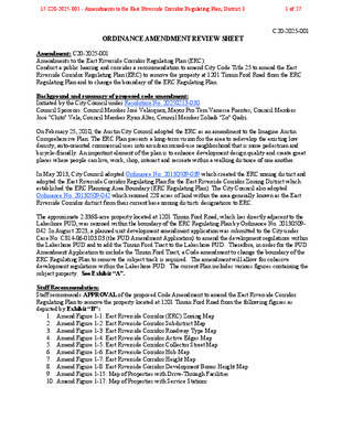
Figure 1-7: East Riverside Corridor Height Map This map shows allowable building heights on a parcel without a development bonus. Subject property City of Austin - East Riverside Corridor Regulating Plan 17 0500’1000’2000’SCALENORTHE. RIVERSIDE DRS. PLEASANT VALLEY RDGROVE BLVDMONTOPOLIS DRE. OLTORF STBURTON DRTINNIN FORD RDWOODLAND AVEVARGAS RDFRONTIER VALLEY DRCROSSING PLPARKER LNELMONT DRACC RiversideRuiz LibraryAllison ElementaryBaty ElementaryWILLOW CREEK DRWICKERSHAM LNLady Bird LakeE. RIVERSIDE DRLAKESHORE DRPARKER LNS. PLEASANT VALLEY RDWICKERSHAM LNROYAL CREST DRRIVERSIDE FARMS RDMONTOPOLIS DRGROVE BLVDTHRASHER LNMAXWELL LNAIRPORT COMMERCE RDFAIRWAY STSANTOS STPORTER STHOGAN AVEFELIX STPONCA STKEMP STSUNRIDGE DRBURLESON RDIH-35HWY 71BASTROP HWYFIGURE 1-7: East Riverside Corridor Height MapLEGEND35 feet40 feet50 feet60 feetERC Planning Area BoundaryParcel BoundaryParcel within the ERC Boundary not re-zoned as part of the ERC process This product is for informational purposes and may not have been prepared for or be suitable for legal, engineering, or surveying purposes. It does not represent an on-the-ground survey and represents only the approximate relative location of property boundaries.This product has been produced by the Planning and Development Review Department for the sole purpose of geographic reference. No warranty is made by the City of Austin regarding specific accuracy or completeness.This map shows allowable building heights on a parcel without a development bonus.entitlements as outlined in Article 6. As amended per Ordinance No. _______________ adopted ____________ .20141106-08411-17-201417City of Austin - East Riverside Corridor Regulating Plan15 C20-2025-001 - Amendments to the East Riverside Corridor Regulating Plan; District 310 of 27 Figure 1-8: East Riverside Corridor Development Bonus Height Map This map shows eligible properties and maximum heights allowed with a development bonus. Subject property 18 City of Austin - East Riverside Corridor Regulating Plan 0500’1000’2000’SCALENORTHFIGURE 1-8: East Riverside Corridor Development Bonus Height MapLEGENDIneligible for Development Bonus65 feet120 feet160 feetERC Planning Area BoundaryParcel BoundaryParcel within the ERC Boundary not re-zoned as part of ERC processThis product is for informational purposes and may not have been prepared for or be suitable for legal, engineering, or surveying purposes. It does not represent an on-the-ground survey and represents only the approximate relative location of property boundaries.This product has been produced by the Planning and Development Review Department for the sole purpose of geographic reference. No warranty is made by the City of Austin regarding specic accuracy or completeness.This map shows eligible properties and maximum heights allowed with a development bonus. As amended per Ordinance No. _______________ adopted ____________ .20141106-08411-17-2014nalP gnitalugeR rodirroC edisreviR tsaE - nitsuA fo ytiC81Updated 12/27/2315 C20-2025-001 …
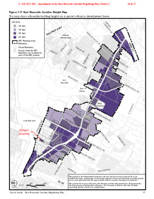
Figure 1-3: East Riverside Corridor Roadway Type Map Indicates the Roadway type for all existing and proposed streets within the ERC boundary. City of Austin - East Riverside Corridor Regulating Plan 13 0500’1000’2000’SCALENORTHE. RIVERSIDE DRS. PLEASANT VALLEY RDGROVE BLVDMONTOPOLIS DRE. OLTORF STBURTON DRTINNIN FORD RDWOODLAND AVEVARGAS RDFRONTIER VALLEY DRCROSSING PLPARKER LNELMONT DRACC RiversideRuiz LibraryAllison ElementaryBaty ElementaryWILLOW CREEK DRWICKERSHAM LNLady Bird LakeE. RIVERSIDE DRLAKESHORE DRPARKER LNBURTON DRS. PLEASANT VALLEY RDWICKERSHAM LNROYAL CREST DRRIVERSIDE FARMS RDMONTOPOLIS DRGROVE BLVDTHRASHER LNMAXWELL LNAIRPORT COMMERCE RDFAIRWAY STSANTOS STPORTER STHOGAN AVEFELIX STPONCA STKEMP STSUNRIDGE DRBURLESON RDIH-35HWY 71BASTROP HWYLEGENDERC Core Transit CorridorERC Pedestrian Priority Collector (PPC) Existing streetsERC Pedestrian Priority Collector (PPC) Future StreetsERC Urban Roadway (UR) Existing streetsERC Highway (HWY)ERC Zoned ParcelParcel within the ERC Boundary not re-zoned as part of the ERC processERC Planning Area BoundaryParcel BoundaryNote: All new streets not identified as another roadway type on this map will be designated ERC Urban Roadways.This product is for informational purposes and may not have been prepared for or be suitable for legal, engineering, or surveying purposes. It does not represent an on-the-ground survey and represents only the approximate relative location of property boundaries.This product has been produced by the Planning and Development Review Department for the sole purpose of geographic reference. No warranty is made by the City of Austin regarding specific accuracy or completeness.15 C20-2025-001 - Amendments to the East Riverside Corridor Regulating Plan; District 317 of 27 Figure 1-4: East Riverside Corridor Active Edges Map This map shows properties that have an active edge requirement and on which street face the active edge is located. The requirements for Active Edges can be found in Section 5.6 of this document. 14 City of Austin - East Riverside Corridor Regulating Plan E. RIVERSIDE DRS. PLEASANT VALLEY RDGROVE BLVDMONTOPOLIS DRE. OLTORF STTINNIN FORD RDWOODLAND AVEVARGAS RDFRONTIER VALLEY DRCROSSING PLPARKER LNELMONT DRACC RiversideRuiz LibraryAllison ElementaryBaty ElementaryWILLOW CREEK DRWICKERSHAM LNLady Bird LakeE. RIVERSIDE DRLAKESHORE DRPARKER LNBURTON DRS. PLEASANT VALLEY RDWICKERSHAM LNROYAL CREST DRRIVERSIDE FARMS RDMONTOPOLIS DRGROVE BLVDTHRASHER LNMAXWELL LNAIRPORT COMMERCE RDFAIRWAY STSANTOS STPORTER STHOGAN AVEFELIX STPONCA STKEMP STSUNRIDGE DRBURLESON RDIH-35HWY 71BASTROP HWY0500’1000’2000’SCALENORTH LEGENDActive EdgesERC Zoned ParcelERC Planning Area BoundaryParcel BoundaryParcel within the ERC Boundary not re-zoned as part of ERC processThis product is for informational purposes and may not have been prepared for or be suitable for legal, engineering, or surveying purposes. It does not represent an on-the-ground survey and represents only the approximate relative location of property boundaries.This …
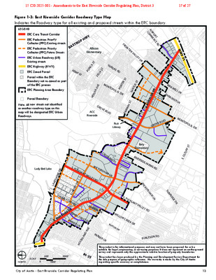
Figure 1-15: Map of Properties with Drive-Through Facilities Map of properties to which Subsection 2.3.5.B (Drive-Through Facilities) and Subsection 4.5 (Drive- Through Facilities) applies. LEGEND ERC Zoned Parcel Parcel within the ERC Boundary that will not be re-zoned as part of ERC Process ERC Planning Area Boundary Parcel Boundary ERC Zoned Property with drive-through facility legally constructed or permitted prior to May 9, 2013. O R T S A B Y W P H SP-2013-0148C Allison Elementary SP-2013-0107C F R O N TIE R V A A I R C O P O M R M T E R C E R D NCA ST PO KEM P ST V A R G AS R D NTOPOLIS DR FELIX ST M O E N AV A G O H L L E Y D R RTER ST O P S ST TO N A S GROVE BLVD ACC Riverside 463939 T Y S A W FAIR Ruiz Library R E D SID R E E. RIV V D L E B G R O V H W Y 7 1 M A X W ELL LN T H R A S H ER L N M O NTOPOLIS DR Baty Elementary RIVERSIDE FAR MS RD T F S R O LT E. O C R O S SIN G P L S. PLEASA WICKERSHA M LN NT VALLEY RD Lady Bird Lake 285507 463854 507723 507721 285464 SP-2012-03 79C 283800 283792 E. RIVERSIDE DR R E D R O H S E K A L TIN NIN FORD RD 729529 729530 285511 R E D S I D R 719303 E E . R I V 285451 ROYAL CREST DR PARKER LN 445742 286707 363720 S. PLEASA NT VALLEY RD W I C K E R S H A M L N S U N R I D G E D R B U R T O N D R WILLO W CREEK DR 808927 D AVE N DLA O O W PARKER LN B U R L E S O N R D SCALE NORTH 0 1000’ 500’ 2000’ IH-35 This product is for informational purposes and may not have been prepared for or be suitable for legal, engineering, or surveying purposes. It does not represent an on-the-ground survey and represents only the approximate relative location of property boundaries. This product has been produced by the Planning and Development …
ZONING CHANGE REVIEW SHEET CASE: Lakeshore PUD Amendment #3 DISTRICT: 3 (C814-06-0109.03) ADDRESS: 2101-2407 1/2 South Lakeshore Blvd; 1201-1401 1/2 Tinnin Ford Rd; 2200-2518 Elmont Dr; 2200-2300 1/2 Waterloo City Ln; 1401-1405 1/2 Violet Crown Ln; 2300-2316 1/2 Oracle Way,1201 and 1201 1/2 Lady Bird Ln ZONING FROM: ERC-NMU and PUD-NP TO: PUD-NP (add approximately 2.3368 acres to the PUD, add additional permitted site development uses regulations on the property to allow for the expansion of the Oracle campus). and modify SITE AREA: approximately 50.15 acres of originally approved PUD (approximately 2,184,534 square feet), plus approximately 2.3368 acres of additional area (approximately 101,791 square feet) PROPERTY OWNER: Oracle America, Inc. AGENT: Armbrust & Brown, PLLC (Richard T. Suttle, Jr.) CASE MANAGER: Jonathan Tomko (512) 974-1057, jonathan.tomko@austintexas.gov STAFF RECOMMEDATION: Staff recommends granting a third amendment to the planned unit development- neighborhood plan (PUD-NP), provided that the applicant provide a 12’ public trail to be built concurrently with phases of the PUD adjacent to Willow Creek Greenway, as they are constructed. Public trail alignment shall run parallel to Willow Creek Greenway, connecting Elmont Dr. to Lakeshore Blvd. For a summary of the basis of Staff’s recommendation, please see the basis of recommendation section below. PLANNING COMMISSION / OTHER COMMITTEE ACTION/RECOMMENDATION: October 8, 2024: Staff request for indefinite postponement, granted. April 8, 2025: Staff postponement request to April 22, 2025 Planning Commission, granted. April 9, 2025: Case is scheduled to be heard by the Small Area Joint Planning Committee. April 22, 2025: Staff postponement request to May 13, 2025 Planning Commission, granted. May 13, 2025: Staff postponement request to May 27, 2025 Planning Commission, granted. May 19, 2025: Parks and Recreation Board motion to recommend to Austin City Council that the Lakeshore PUD Amendment Development application is superior with respect to parkland dedication was approved on Board Member Villalobos’ motion, Vice Chair Flowers’ second on a 9-0 vote. Board Members Orme and Taylor absent. May 27, 2025: Case is scheduled to be heard by the Planning Commission. CITY COUNCIL ACTION: 16 C814-06-0109.03 - Lakeshore PUD Amendment #3; District 31 of 38 February 13, 2025: Council approved Resolution No. 20250213-030 to initiate code amendment C20-2025-001 to remove the property located at 1201 Tinnin Ford Road from the East Riverside Corridor (ERC) Regulating Plan. June 5, 2025: Case is scheduled to be heard by City Council. ORDINANCE NUMBER: N/A ISSUES: The subject tract is within …
PSH – LifeWorks at Tillery SP-2025-0031C.SH Environmental Commission May 7, 2025 Heritage Tree Variance Request COMMISSION MEETING DATE: May 7th, 2025 NAME & NUMBER OF PROJECT: PSH – LifeWorks at Tillery, SP-2025-0031C.SH APPLICANT NAME: 3423 Tillery LLC LOCATION: 819 Tillery Street, Austin, TX, 78702 COUNCIL DISTRICT: District 3 STAFF: ORDINANCE: REQUEST: Naomi Rotramel, City Arborist, Development Services Department Heritage Tree Ordinance (LDC 25-8-641; LDC 25-8-643) The applicant is seeking the removal of a Heritage tree with a single stem over 30 inches in diameter. STAFF RECOMMENDATION: The request meets City Arborist approval criteria set forth in LDC 25-8-624(A)(2). The variance is recommended. Levels of Tree Ordinance Protection Land Development Code Approval Criteria Site and Project Description Site: • Zoned CS-MU-CO-MP: General Commercial Services, Mixed-Use Combining District, Conditional Overlay, and Neighborhood Plan Combining District • Located within the Boggy Creek watershed, classified as an urban watershed regulation area • The entire lot is 13 acres Project: • The site will be developed in three phases • The proposed development will consist of: • 120 SMART Housing Permanent Supportive Housing (PSH) units on a one-acre lease • 240 Units at or below 80% Median Family Income (MFI) • 240 additional units • Two multifamily residential buildings and a few adjacent retail buildings along with one major driveway entry to the site from Tillery Street • Mixed use residential building with a sub-surface parking garage along Lyons Road Land Use Commission Variance Request Lease Area Phase 1 – Permanent Supportive Housing • One (1) Land Use Commission Heritage Pecan tree that is not either dead, diseased, or imminent hazard. • Tree #3510 has a single stem with a diameter of 32 inches and is centrally located within the PSH lease area. Alternative Layouts Preserving Tree 3510 Preservation of 34 Heritage Trees Phase I, II, &III • Commitment to meet preservation criteria in Environmental Criteria Manual (ECM 3.5.2) of 34 Heritage Trees • One Heritage tree transplant Administrative Variances • Six trees deemed dead, diseased, or imminent hazard (DDI) by five City Arborist staff • Four trees in poor condition • Two trees in fair and good condition Heritage Tree #3510 • Existing unpermitted impacts and soil compaction Limb failure and multiple attachments • • Structural defects • Fair to poor condition Heritage Tree #3510 • Cavity at load-bearing attachment of several scaffold limbs Tree #3510 Previously failed large limbs 4-8”diameter throughout the canopy …
SITE PLAN REVIEW SHEET ENVIRONMENTAL VARIANCE REQUEST ONLY CASE: SP-2025-0031C.SH P.C. COMMISSION DATE: May 27, 2025 PROJECT NAME: PSH – LifeWorks at Tillery ADDRESS OF SITE: 819 Tillery Street, Austin TX 78702 COUNCIL DISTRICT: District 3 AREA: The entire property comprises 13 acres, with a 1-acre portion located in the back east corner leased to LifeWorks to support the Permanent Supportive Housing (PSH) project. WATERSHED: Boggy Creek JURISDICTION: Full purpose OWNER: 3423 Tillery LLC APPLICANT: Civilitude LLC, Nhat Ho 5110 Lancaster Court Austin, TX 78723 (512) 761-6161 AGENT: Civilitude LLC PROPOSED DEVELOPMENT: The applicant is proposing a mixed-use development, built over 13 acres in three separate phases. The project proposes to provide over 600 residential units to the East Austin neighborhood, with 120 SMART Housing units within the 1 acre leased lot proposed for the Permanent Supportive Housing project. DESCRIPTION OF VARIANCE: The applicant is seeking the removal of a Heritage tree with a single stem over 30 inches in diameter. STAFF RECOMMENDATION WITH CONDITIONS: The request meets City Arborist approval criteria set forth in LDC 25-8-624(A)(2). The variance is recommended. • The Environmental Criteria Manual (ECM) standard is 300% mitigation for Heritage trees. Heritage tree #3510 is a 32-inch Pecan. The project will account for the 96 inches owed. ENVIRONMENTAL COMMISSION MOTION: 05/07/2025: The Environmental Commission voted (8) in favor for the approval of the requested variance, (1) in denial of the requested variance, (1) abstaining, and (1) absentia. ENVIRONMENTAL REVIEW STAFF: Naomi Rotramel, City Arborist PHONE: 512-974-9135 CASE MANAGER: Meg Greenfield PHONE: 512-978-4663 17 SP-2025-0031C.SH - PSH Lifeworks at Tillery; District 31 of 52 ENVIRONMENTAL COMMISSION MOTION 20250507-004 Date: May 7, 2025 Subject: PSH – LifeWorks at Tillery, SP-2025-0031C.SH Location: 819 Tillery Street, Austin, TX, 78702 Motion by: Hanna Cofer Seconded by: Jennifer Bristol WHEREAS, the Environmental Commission recognizes the applicant is seeking removal of a Heritage tree with a stem greater than 30 inches in accordance with LDC § 25-8-643 and § 25-8- 624(A)(2); and WHEREAS, the Environmental Commission recognizes that the tree requested for removal is a 32-inch diameter Heritage pecan (Tree #3510), located within the one-acre lease area designated for Permanent Supportive Housing (PSH) on a 13-acre site; and WHEREAS, the Environmental Commission recognizes that the City Arborist rates the pecan tree as being in fair overall condition but with poor structural integrity, a moderate risk rating, and documented defects including large limb failures and …
PLANNING COMMISSION DOWNTOWN DENSITY BONUS REQUEST SITE PLAN REVIEW SHEET CASE NUMBER: SP-2024-0238C PLANNING COMMISSION HEARING DATE: May 27, 2025 PROJECT NAME: 305 W. MLK – Home2 ADDRESS: 305, 307, and 309 West Martin Luther King Jr. Boulevard OWNER: PA Hospitality – Austin Downtown, LP APPLICANT: Thrower Design (Victoria Haase) URBAN DESIGN STAFF: Jorge E. Rousselin, CNU-A Jorge.Rousselin@austintexas.gov Phone: (512) 974-2975 SITE PLAN CASE MANAGER: Randall Rouda randall.ruda@austintexas.gov Phone: (512) 978-4665 NEIGHBORHOOD PLAN: Downtown PROPOSED DEVELOPMENT: The applicant is requesting administrative approval for the construction of a 13-story hotel comprised of 168 rooms with retail and streetscape improvements in accordance with the Downtown Density Bonus Program (DDBP). PROJECT REQUEST: In accordance with LDC Section 25-2-586(B)(6), the applicant is requesting, from City Council, additional floor-to-area ratio (FAR) from 8:1 to 11:1 for a proposed hotel building. The project is participating in the DDBP for bonus area up to 8:1 FAR to be granted administratively. PRIOR BOARD AND COMMISSION ACTION: Design Commission: October 28, 2024: The motion that the project 305 W MLK, located at 305 West Martin Luther King Jr. Boulevard, does not comply with the Urban Design Guidelines for the City of Austin in accordance with Land Development Code § 25-2-586 (C)(1)(a)(ii) was approved with the following friendly amendments on motion by Commissioner Howard, seconded by Vice Chair Meiners on a 9-0-1 vote. Commissioner Carroll abstained. One vacancy on the dais. The friendly amendment from Vice Chair Meiners was that the project is not in compliance with the following Urban Design Guidelines: AW.5 – Incorporate Civic Art in Both Public and Private Development PS.1 – Protect the Pedestrian Where the Building Meets the Street PS.2 – Minimize Curb Cuts PS.4 – Reinforce Pedestrian Activity PS.6 – Enhance the Streetscape PS.7 – Avoid Conflicts between Pedestrians and Utility Equipment 18 SP-2024-0238C - 305 W. MLK – Home21 of 7 PS.9 – Provide Pedestrian-Scaled Lighting PS.10 – Provide Protection from Cars/Promote Curbside Parking PS.12 – Provide Generous Street-Level/Windows PS.13 – Install Pedestrian-Friendly Materials at Street Level B.2 – Provide Multi-Tenant, Pedestrian-Oriented Development at the Street Level B.3 – Accentuate Primary Entrances B.4 – Encourage the Inclusion of Local Character B.5 – Control On-Site Parking B.7 – Create Buildings with Human Scale The friendly amendment by Commissioner Wittstruck was to encourage the removal of the driveway along the principal street and provide access via the alley; and if not feasible, align the driveway …
PLANNING COMMISISON SITE PLAN CONDITIONAL USE PERMIT REVIEW SHEET CASE NUMBER: PROJECT NAME: SPC-2024-0342C MLK Storage PC DATE: May 27, 2025 ADDRESS: NEIGHBORHOOD PLAN: Pecan Springs-Springdale CITY COUNCIL DISTRICT: 1 5718 E Martin Luther King Jr. Blvd APPLICANT: East Austin Storage 2, LLC (Andrew Guinn) 4407 Bee Caves Road, Unit 421, West Lake Hills, TX. 78746 AGENT: LJA Engineering (Eva Wong) 7500 Rialto Blvd, Bldg 2, Ste. 100 Austin, TX 78735 877-367-2410 512-439-4700 CASE MANAGER: Alyse Ramirez 512-978-1750 Alyse.ramirez@austintexas.gov 1.05 acres (Limits of Construction) AREA: EXISTING ZONING: CS-CO-NP WATERSHED: WATERSHED ORDINANCE: Comprehensive Watershed Ordinance T.I.A.: CAPITOL VIEW: Walnut Creek N/A N/A PROPOSED DEVELOPMENT: The applicant is requesting approval of a conditional use permit site plan for construction of one (1) storage building totaling approximately 90,075 feet, surface parking, drives, and associated utility and drainage improvements. The applicant is requesting the approval per zoning ordinance 021107-Z-12a to allow a convenience storage use. Planning Commission approval is required because the site is zoned CS-CO-NP. The LDC Section 25-2- 584(F)(2) states: “(F) The Land Use Commission may approve, in accordance with the applicable provisions of Chapter 25-5, Article 3 (Land Use Commission Approved Site Plans), the following modifications to the site development regulations: a structure with a convenience storage use. SUMMARY STAFF RECOMMENDATION: Staff recommends approval of the conditional use permit because it meets all applicable criteria The site plan will comply with all code requirements prior to site plan release. Land Use: The proposed site is located along the 5700 block of East Martin Luther King Jr. Boulevard and falls within a tract zoned CS-CO-NP. Since the proposed use is Convenience Storage in tract 28B of the Pecan Springs-Springdale Neighborhood Plan, a conditional use permit is required per the zoning ordinance 021107-Z-12a, and this site plan must be approved by a Land Use Commission. The current land use is vacant, and the proposed use is Convenience Storage. Environmental: No variances required or requested. 19 SPC-2024-0342C - MLK Storage; District 11 of 7 SPC-2024-0342C MLK Storage 2 OVERALL SITE PROJECT INFORMATION SITE AREA EXISTING ZONING PROPOSED ACCESS FLOOR-AREA RATIO BUILDING COVERAGE IMPERVIOUS COVERAGE 1.05 AC CS-CO-NP East MLK Jr. Blvd Existing 00:1 0% 0% Proposed 1.99:1 39.88% 72.43% NEIGHBORHOOD ORGNIZATIONS Austin Independent School District, Austin Neighborhoods Council, Del Valle Community Coalition, East Austin Conservancy, East MLK Combined Neighborhood Plan Contact Team, Friends of Austin Neighborhoods, Friends of Northeast Austin, Homeless Neighborhood Association, Overton …
PLANNING COMMISSION SITE PLAN REVIEW SHEET CONDITIONAL USE SITE PLAN APPROVAL CASE NUMBER: SPC-2024-0073C PC DATE: May 27th, 2025 PROJECT NAME: 3404 Govalle Avenue ADDRESS: 3404 GoValle Ave AREA: 2.07 acres APPLICANT: AGENT: Voices Rising, LLC C/O Frost FWA PO Box 749 Corpus Christi, TX 78403-0749 Phone: (512) 573-7057 Anthony Goode (Goode Faith Engineering) 1620 La Jaita Dr # 300 Cedar Park, TX 78613 Phone: (972) 822-1682 EXISTING ZONING: SF-3-NP PROPOSED DEVELOPMENT: Approval of a conditional use permit to allow for a cultural services use in an SF-3-NP zoning district. AREA STUDY: Govalle WATERSHED: Boggy Creek APPLICABLE WATERSHED ORDINANCE: Current/ Comprehensive Watershed Ordinance CAPITOL VIEW: N/A T.I.A.: Not Required SUMMARY STAFF RECOMMENDATION: Staff recommends approval of a conditional use permit to allow for a cultural services use in an SF-3- NP zoning district. The related site plan has been reviewed in accordance with all requirements of the Land Development Code once submitted. CASE MANAGER: Gabriel Guerrero Jr. Telephone: (512) 978-4658 Gabriel.Guerrero@austintexas.org 20 SPC-2024-0073C - 3404 Govalle Avenue ; District 31 of 8 SPC-2024-0073C 3404 Govalle Avenue Page 2 PROJECT INFORMATION: ZONING: SF-3-NP MAX. BLDG. CVRG: 40% MAX. HEIGHT: 35 ft. MAX. IMP. CVRG: 45% EXIST. USE: Residential / Civic PROP. BLDG. CVRG: 21.4% PROP.HEIGHT: 27’ 7” PROP. IMPERV. CVRG.: 44.5% PROPOSED USE: Civic SUMMARY COMMENTS ON SITE PLAN: Land Use: The submitted site plan is for the approval of a conditional use permit to allow for a cultural services use in an SF-3-NP zoning district. The uses included under cultural services are (admin office, indoor music performance, theater and art gallery). The related site plan has been reviewed in accordance with all requirements of the Land Development Code. Environmental: The site is not located in the Edward's Aquifer Recharge Zone. The site is in the Harper’s Branch watershed. SURROUNDING CONDITIONS: Zoning/ Land use: North: SF-3-NP / Residential East: SF-3-NP / Residential South: SF-3-NP / Residential West: SF-3-NP / Urban Farm Street Govalle Ave R.O.W. 60’ Surfacing 39’ Classification Level 2 NEIGHBORHOOD ORGANIZATION: Austin Independent School District, Austin Neighborhoods Council, Del Valle Community Coalition, East Austin Conservancy, Friends of Austin Neighborhoods, Govalle Neighborhood Association, Govalle/Johnston Terrace Neighborhood Plan Contact Team, Guadalupe Neighborhood Development Corporation, Homeless Neighborhood Association, Overton Family Committee , Preservation Austin 20 SPC-2024-0073C - 3404 Govalle Avenue ; District 32 of 8 SPC-2024-0073C 3404 Govalle Avenue Page 3 CONDITIONAL USE PERMIT REVIEW AND EVALUATION CRITERA The following evaluation is …