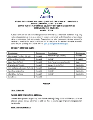
REGULAR MEETING OF THE LGBTQ QUALITY OF LIFE ADVISORY COMMISSION MONDAY, MARCH 9, 2026 AT 6:30 P.M. CITY OF AUSTIN PERMITTING & DEVELOPMENT CENTER, ROOM #1407 6310 WILHELMINA DELCO DR. AUSTIN, TEXAS Public comment will be allowed in-person or remotely via telephone. Speakers may only register to speak on an item once either in-person or remotely and will be allowed up to three minutes to provide their comments. Registration no later than noon the day before the meeting is required for remote participation by telephone. To register to speak remotely, contact Ryan Sperling at 512-974-3568 or ryan.sperling@austintexas.gov. CURRENT COMMISSIONERS : Commissioner Appointment Kitty McLeod, Vice Chair (they/he) District 1 Commissioner Mariana Krueger (she/her) KC Coyne, Chair (they/he) Steven Rivas (he/him) Brigitte Bandit (they/she) District 2 District 3 District 4 VACANT Rocío Fierro-Pérez (she/her/ella) Mayor Morgan Davis (he/him) Appointment District 9 District 10 Stakeholder Stakeholder Stakeholder Stakeholder Jerry Joe Benson, Secretary (he/him) District 5 Randy Pituk Asher Knutson (he/him) J. Scott Neal (he/him) Garry Brown District 6 District 7 District 8 VACANT VACANT AGENDA CALL TO ORDER PUBLIC COMMUNICATION: GENERAL The first ten speakers signed up prior to the meeting being called to order will each be allowed a three-minute allotment to address their concerns regarding items not posted on the agenda. APPROVAL OF MINUTES 1. Approve the minutes of the LGBTQ Quality of Life Advisory Commission regular meeting of February 9, 2026. DISCUSSION ITEMS 2. 3. 4. 5. 6. Presentation regarding the PHLIV Stigma Index and an HIV Resource Guide. Presentation by Michelle Osorio, Public Health Program Coordinator, Austin Public Health and Rick Astray-Caneda III, President, Friends of the David Powell Clinic. Presentation by Austin Pride to provide a high-level update and coordination conversation focused on early planning and alignment for 2026 Austin PRIDE. Presentation by Micah Andress, President, Austin PRIDE. Discussion regarding a priority list for which organizations to invite to present at commission meetings. Discussion regarding a view-only folder for commissioner resources. Discussion regarding potential collaboration with the LGBTQ Chamber of Commerce. WORKING GROUP RECOMMENDATIONS 7. Report from the FY2026-27 Budget Working Group regarding its proposed budget recommendations. DISCUSSION AND ACTION ITEMS 8. 9. 10. 11. 12. 13. 14. Approve a budget recommendation for LGBTQ legal navigation and community safety coordination. Approve a budget recommendation for expansion of Mpox, STI, and Vaccination Programs. Approve a recommendation for safety preparedness & first response expansion. Approve a budget recommendation for …
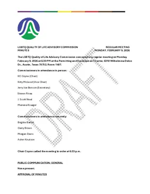
LGBTQ QUALITY OF LIFE ADVISORY COMMISSION REGULAR MEETING MINUTES MONDAY, FEBRUARY 9, 2026 The LGBTQ Quality of Life Advisory Commission convened in a regular meeting on Monday, February 9, 2026 at 6:30 PM at the Permitting and Development Center, 6310 Wilhelmina Delco Dr., Austin, Texas 78752, Room 1407. Commissioners in attendance in person: KC Coyne (Chair) Kitty McLeod (Vice Chair) Jerry Joe Benson (Secretary) Steven Rivas J. Scott Neal Mariana Krueger Commissioners in attendance remotely: Brigitte Bandit Garry Brown Morgan Davis Asher Knutson Chair Coyne called the meeting to order at 6:33 p.m. PUBLIC COMMUNICATION: GENERAL None present. APPROVAL OF MINUTES 1. Approve the minutes of the LGBTQ Quality of Life Advisory Commission Special Called meeting on January 26, 2026. The minutes were approved on Commissioner Krueger’s motion, Secretary Benson’s second on an 8-0 vote. Commissioners Knutson and Neal were o(cid:431) the dais. Commissioner Fierro-Pérez was absent. DISCUSSION ITEMS 2. 3. 4. Presentation providing an update on American Gateways’ successes and requesting prioritization of immigration funds in next year’s budget. Presentation by Edna Yang, Co- Executive Director, American Gateways. The presentation was made by Edna Yang, Co-Executive Director, American Gateways. Update and discussion regarding Austin’s LGBTQ+ healthcare Presentation by Juan Benitez, Chief Advancement O(cid:431)icer, Texas Health Action. The presentation was made by Juan Benitez, Chief Advancement O(cid:431)icer, Texas Health Action. funding needs. Update on the progress of the LGBTQ+ Cultural Center Feasibility Study Task Force. Update by Chair Coyne. WORKING GROUP UPDATES 5. 6. 7. Update from the Community Safety Working Group regarding their work around city preparedness and response to federal immigration enforcement, public safety concerns and APD presence downtown, initial and ongoing feedback to APD for cadet training, and planning for a future commission visit focused on trauma-informed public safety engagement. Update by Commissioner Benson. Update from the Budget Working group sharing a high-level overview of their current budget priorities, key proposals under development, and the timeline for submissions to City Council. Update by Commissioner Benson. Update from the New Commissioner Working Group regarding its progress on recruitment for the final vacant stakeholder commissioner seat. Item 7 was taken up after Item 1 without objection. Update by Commissioner Brown. The meeting went into recess without objection at 8:18 p.m. The meeting was called back into order at 8:28 p.m. DISCUSSION AND ACTION ITEMS 8. Nominate a stakeholder commissioner to fill the vacant stakeholder seat on the commission. Item …
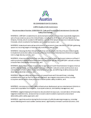
. RECOMMENDATION TO COUNCIL LGBTQ Quality of Life Commission Recommendation Number: 20260309-010: Safe and Proud Austin Entertainment Corridor Life Safety Pilot Package WHEREAS, LGBTQIA+ establishments and entertainment venues have been repeatedly targeted in acts of mass violence across the United States, including the 2016 attack at Pulse Nightclub in Orlando, Florida, which resulted in 49 fatalities, and the 2022 attack at Club Q in Colorado Springs, Colorado, which resulted in five fatalities and numerous injuries; and WHEREAS, federal and national law enforcement assessments have identified LGBTQIA+ gathering spaces as recurring targets of ideologically motivated violence; and WHEREAS, following the New Orleans Mardi Gras vehicle attack, the City of Austin moved rapidly to implement protective safety measures within the Sixth Street Entertainment District to mitigate risk in a high density corridor; and WHEREAS, it has now been more than one year since that incident, and recent violence on March 1 within proximity to Bettie Naylor Street demonstrates that high density LGBTQIA+ cultural corridors in Austin face comparable risk exposure; and WHEREAS, Bettie Naylor Street, historically recognized as Fourth Street between Congress Avenue and Rio Grande Street, serves as Austin's primary LGBTQIA+ cultural corridor and functions as a concentration of bars, coffee shops, entertainment venues, and affirming small businesses that draw high pedestrian volumes; and WHEREAS, adjacent affirming businesses on Lavaca Street and Colorado Street, including establishments such as The Iron Bear and Highland, are integral components of this corridor ecosystem and lie within close proximity to recent public safety incidents; and WHEREAS, consistency in public safety infrastructure deployment across entertainment districts is essential to equitable risk mitigation, municipal resilience, and liability management; and WHEREAS, targeted deployment based on documented risk exposure, concentration of historically targeted establishments, and proximity to recent violent incidents represents a tiered and defensible public safety approach; and WHEREAS, rapid intervention during the first minutes of a life threatening emergency, including severe bleeding events and sudden cardiac arrest, significantly increases survival outcomes; and . WHEREAS, public safety best practices emphasize layered mitigation strategies including early notification, immediate hemorrhage control, defibrillation access, community CPR activation, and coordinated emergency response; and WHEREAS, the Austin Travis County EMS Chief Medical Officer requested funding for Community CPR Alerting and AED Deployment to Enhance Equity, including investment in the GoodSAM platform to improve cardiac arrest outcomes through real time scene awareness and verified responders, and alignment with this corridor safety pilot would strengthen …
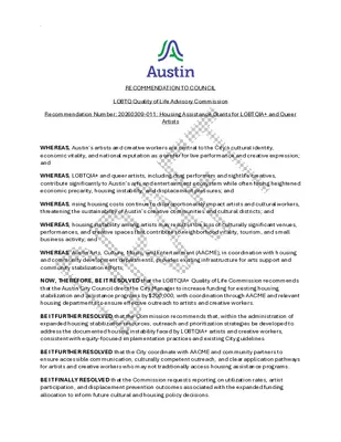
. RECOMMENDATION TO COUNCIL LGBTQ Quality of Life Advisory Commission Recommendation Number: 20260309-011: Housing Assistance Grants for LGBTQIA+ and Queer Artists WHEREAS, Austin’s artists and creative workers are central to the City’s cultural identity, economic vitality, and national reputation as a center for live performance and creative expression; and WHEREAS, LGBTQIA+ and queer artists, including drag performers and nightlife creatives, contribute significantly to Austin’s arts and entertainment ecosystem while often facing heightened economic precarity, housing instability, and displacement pressures; and WHEREAS, rising housing costs continue to disproportionately impact artists and cultural workers, threatening the sustainability of Austin’s creative communities and cultural districts; and WHEREAS, housing instability among artists may result in the loss of culturally significant venues, performances, and creative spaces that contribute to neighborhood vitality, tourism, and small business activity; and WHEREAS, Austin Arts, Culture, Music, and Entertainment (AACME), in coordination with housing and community development departments, provides existing infrastructure for arts support and community stabilization efforts; NOW, THEREFORE, BE IT RESOLVED that the LGBTQIA+ Quality of Life Commission recommends that the Austin City Council direct the City Manager to increase funding for existing housing stabilization and assistance programs by $200,000, with coordination through AACME and relevant housing departments to ensure effective outreach to artists and creative workers. BE IT FURTHER RESOLVED that the Commission recommends that, within the administration of expanded housing stabilization resources, outreach and prioritization strategies be developed to address the documented housing instability faced by LGBTQIA+ artists and creative workers, consistent with equity-focused implementation practices and existing City guidelines. BE IT FURTHER RESOLVED that the City coordinate with AACME and community partners to ensure accessible communication, culturally competent outreach, and clear application pathways for artists and creative workers who may not traditionally access housing assistance programs. BE IT FINALLY RESOLVED that the Commission requests reporting on utilization rates, artist participation, and displacement prevention outcomes associated with the expanded funding allocation to inform future cultural and housing policy decisions. . Date of Approval: Motioned By: Vote: For: Against: Abstain: Off the dais: Absent: Seconded By: Attest: _____________________________________________ Ryan Sperling, LGBTQ Quality of Life Advisory Commission Staff Liaison
. RECOMMENDATION TO COUNCIL LGBTQ Quality of Life Advisory Commission Recommendation Number: 20260309-012: Community Liaison Officer Program Pilot WHEREAS, the City of Austin has committed to community-centered public safety strategies that prioritize trust-building, accessibility, and culturally competent engagement with historically marginalized communities, including LGBTQIA+ residents; and WHEREAS, the LGBTQIA+ Quality of Life Commission, the Joint Inclusion Committee, and other City commissions have received consistent feedback from community members regarding the need for improved communication, responsiveness, and accountability in interactions with law enforcement; and WHEREAS, the City of Austin and Austin Police Department have previously endorsed the Community Liaison Officer Expansion and Empowerment framework, which calls for strengthening and formalizing the Community Liaison function as a core community engagement strategy; and WHEREAS, Austin Police Department currently maintains liaison functions, and a pilot model incorporating both civilian coordination and sworn, uniformed officers may strengthen visibility, accessibility, and community trust; and WHEREAS, leadership within APD has indicated that initial implementation can be achieved primarily through internal realignment of existing personnel and currently vacant positions, without requiring a significant increase in overall staffing levels; and WHEREAS, successful implementation depends on assigning experienced and community- connected personnel, prioritizing liaison responsibilities within departmental operations, and establishing clear procedures, training, and data practices to support long-term program effectiveness; and WHEREAS, a phased pilot approach allows the City to evaluate effectiveness, community impact, and operational needs before considering broader expansion or long-term funding commitments; NOW, THEREFORE, BE IT RESOLVED that the LGBTQIA+ Quality of Life Commission recommends that the Austin City Council direct the City Manager to allocate Phase One pilot funding to support initial implementation of the Community Liaison Officer Program Pilot. BE IT FURTHER RESOLVED that the pilot model include both civilian coordination support and sworn, uniformed APD Community Liaison Officers, utilizing experienced personnel where feasible, with an emphasis on individuals who maintain established relationships with LGBTQIA+ and historically marginalized communities. . BE IT FURTHER RESOLVED that the Austin Police Department establish internal procedures to prioritize liaison responsibilities within assigned duties, ensuring sworn officers participating in the pilot are able to consistently fulfill community engagement, outreach, and responsiveness commitments associated with the role. BE IT FURTHER RESOLVED that Phase One pilot funding support the following limited and targeted activities: • Designation and operational support of sworn LGBTQIA+ Community Liaison Officers utilizing existing APD personnel where feasible • Initial training and professional development related to cultural competency, …
. RECOMMENDATION TO COUNCIL LGBTQ Quality of Life Advisory Commission Recommendation Number: 20260309-013: Gender Neutral Restroom Accessibility Initiative WHEREAS, the State of Texas has enacted Senate Bill 8 (2025), establishing restrictions on restroom use in certain public facilities and requiring local governments to maintain compliance; and WHEREAS, single-occupancy and all-gender restroom models are widely recognized as effective approaches to improving safety, accessibility, and privacy for a broad range of users, including families, people with disabilities, and gender-diverse individuals; and WHEREAS, many small businesses, nonprofits, and community-serving institutions in Austin have expressed interest in transitioning to all-gender or single-user restroom models but face financial and infrastructure barriers; and WHEREAS, improving restroom accessibility and flexibility can support public health, customer access, workforce inclusion, and small business resilience; and WHEREAS, the City has previously utilized no-interest loan and incentive models to support voluntary accessibility and facility improvements among small and locally owned businesses; NOW, THEREFORE, BE IT RESOLVED that the LGBTQIA+ Quality of Life Commission recommends that the Austin City Council direct the City Manager to develop and implement a Gender-Neutral Restroom Accessibility and Small Business Support Initiative to assist private businesses, nonprofits, and community institutions in transitioning to inclusive and flexible restroom models. BE IT FURTHER RESOLVED that the initiative include a no-interest loan or incentive mechanism to support eligible restroom upgrades, including conversion to single-occupancy, all-gender, or universal design restroom configurations, consistent with applicable building and accessibility standards. BE IT FURTHER RESOLVED that program design include clear eligibility criteria and a streamlined process that prioritizes small businesses, nonprofits, and community-serving venues that may face capital access constraints. BE IT FURTHER RESOLVED that the Commission recommends an initial funding commitment of $200,000 and encourages exploration of diverse funding sources, including partnerships, community development resources, and external funding opportunities, to minimize impact on the City’s general fund. . BE IT FURTHER RESOLVED that implementation include outreach, technical guidance, and best- practice resources to support participating organizations in designing compliant and accessible restroom facilities. BE IT FURTHER RESOLVED that the program include reasonable timelines and periodic reporting on participation, geographic distribution, and accessibility outcomes to inform future infrastructure and accessibility policy. BE IT FINALLY RESOLVED that the Commission encourages continued evaluation of gender- neutral and single-occupancy restroom models within City-owned facilities, consistent with legal compliance and accessibility best practices. Seconded By: Date of Approval: Motioned By: Vote: For: Against: Abstain: Off the dais: Absent: …
. RECOMMENDATION TO COUNCIL LGBTQ Quality of Life Advisory Commission Recommendation Number: 20260309-014: Entrepreneurial Grants for LGBTQIA+ Businesses WHEREAS, local LGBTQIA+-owned businesses contribute significantly to Austin’s cultural identity, neighborhood character, tourism appeal, and economic vitality; and WHEREAS, small businesses owned by LGBTQIA+ entrepreneurs may face barriers to accessing capital and business development resources, particularly during periods of economic uncertainty and rising operating costs; and WHEREAS, City initiatives supporting historically underserved entrepreneurs have demonstrated success in fostering business stability, local job creation, and neighborhood economic resilience; and WHEREAS, responsible tools such as no-interest loans, technical assistance, and targeted entrepreneurial support can strengthen small business sustainability while maintaining fiscal prudence; and WHEREAS, continued and expanded support for LGBTQIA+ entrepreneurs aligns with the City’s commitments to inclusive economic development, small business resilience, and cultural district preservation; NOW, THEREFORE, BE IT RESOLVED that the LGBTQIA+ Quality of Life Commission recommends that the Austin City Council expand and continue entrepreneurial support initiatives within existing City economic development programs to strengthen access to capital and technical assistance for LGBTQIA+ entrepreneurs. BE IT FURTHER RESOLVED that the Commission recommends allocating $200,000 to enhance no- interest loan capacity and related entrepreneurial assistance within the City’s existing small business support infrastructure. BE IT FURTHER RESOLVED that program implementation include targeted outreach and culturally competent engagement to ensure equitable access for LGBTQIA+ owned businesses, particularly small, locally owned, and community-serving enterprises that may face barriers to traditional financing. BE IT FINALLY RESOLVED that the Commission requests reporting on participation rates, loan performance, and business stabilization outcomes to evaluate program impact and inform future economic development strategies. . Date of Approval: Motioned By: Vote: For: Against: Abstain: Off the dais: Absent: Seconded By: Attest: _____________________________________________ Ryan Sperling, LGBTQ Quality of Life Advisory Commission Staff Liaison
. RECOMMENDATION TO COUNCIL LGBTQ Quality of Life Advisory Commission Recommendation Number: 20260309-015: LGBTQ Cultural District WHEREAS, the State of Texas, through directives to enforce roadway safety and pavement marking compliance, has required removal of decorative and message-based roadway art, including rainbow and culturally themed crosswalks, with potential risk to transportation funding for noncompliance; and WHEREAS, the rainbow crosswalk at West 4th Street and Colorado Street has served as a widely recognized marker of Austin’s LGBTQ cultural and entertainment district, signaling safety, belonging, and civic recognition for LGBTQIA+ residents and visitors; and WHEREAS, the removal of highly visible cultural markers in public spaces may negatively affect community cohesion, cultural tourism, and small business activity within established neighborhood corridors; and WHEREAS, the City of Austin operates a Street Banner Program that provides a lawful and compliant framework for district identity markers, including over-street and street-pole banners, consistent with roadway regulations; and WHEREAS, the development of an LGBTQ Entertainment District, supported by culturally identifiable infrastructure, may strengthen economic activity, tourism, and small business vitality within the district; and WHEREAS, exploration of a Micro Public Improvement District (Micro-PID) or similar localized funding and maintenance structure may provide a sustainable mechanism for district identity infrastructure, programming, and long-term stewardship; and WHEREAS, community-centered public art and engagement processes improve representation, legitimacy, and long-term community ownership of civic cultural markers; and WHEREAS, timely execution of a compliant transition strategy is necessary to meet state- mandated deadlines and minimize disruption to community identity, tourism, and district economic activity; and WHEREAS, this effort aligns with the work of the Mayor’s Task Force on transitioning from decorative crosswalks to compliant public-space district markers and identity infrastructure; NOW, THEREFORE, BE IT RESOLVED that the LGBTQIA+ Quality of Life Commission recommends that the Austin City Council direct the City Manager to prioritize and establish a one-time LGBTQ . Entertainment District Cultural Infrastructure Pilot to replace removed decorative crosswalk markers with compliant district identifiers, including banners, flags, wayfinding elements, and related identity infrastructure, with an initial focus on the West 4th Street corridor. BE IT FURTHER RESOLVED that the Commission recommends allocating $120,000 in one-time funding for design, fabrication, and installation of district identity infrastructure, utilizing the City’s existing Street Banner Program and related standards where feasible. BE IT FURTHER RESOLVED that the pilot include a structured community engagement and local artist process to develop culturally authentic district marker designs reflective of …
The LGBTQIA+ Quality of Life Commission approaches this budget cycle with a clear focus: stability, safety, and resilience. Across Austin, LGBTQIA+ residents are navigating rising housing costs, evolving state policy landscapes, public health funding reductions, and growing economic pressures on small businesses and creative workers. These dynamics are not abstract. They affect access to healthcare, housing stability, public safety, and the ability to participate fully in civic life. This year’s budget recommendations reflect a disciplined approach centered on three priority areas: 1. Health and Human Services 2. Community Safety and Public Space Stability 3. Legal Navigation and Systems Coordination Together, these priorities strengthen prevention, reduce crisis response costs, and preserve Austin’s cultural and economic vitality. Health and Human Services: Prevention Is Cheaper Than Crisis As federal public health funding becomes less predictable, MPox outbreaks, rising STI rates, and ongoing HIV prevention needs remain pressing concerns. The proposed $80,000 expansion of vaccination and prevention programming is a targeted investment that supports outreach and culturally competent care through trusted providers, reducing costly emergency and long-term treatment burdens. At the same time, housing instability among LGBTQIA+ artists and creative workers threatens Austin’s cultural and economic vitality, making the proposed $200,000 expansion of existing housing stabilization resources a practical step to prevent displacement and avoid the higher costs of homelessness intervention. An additional $200,000 to strengthen entrepreneurial grants and no-interest loan capacity for LGBTQIA+-owned small businesses further supports neighborhood stability and economic resilience. Together, these measured investments reinforce prevention, protect economic drivers, and build on systems already in place. Safety: Trust, Visibility, and Public Space Stability Public safety depends on trust, visibility, and functional infrastructure. The proposed $40,000 Community Liaison Officer Pilot formalizes and strengthens an existing APD-supported function through training, communications tools, and basic reporting systems, without expanding staffing, ensuring liaison roles are prioritized and accountable. In response to state-required removal of decorative crosswalks, the $120,000 LGBTQ Entertainment District Cultural Infrastructure Pilot offers a compliant solution that preserves district identity through banners and lawful wayfinding, protecting tourism and small business activity. Continued in-kind City support for Austin Pride follows the same logic, recognizing Pride as both a cultural and economic driver while strengthening transparency and advisory input. Finally, the $200,000 Gender-Neutral Restroom Accessibility Initiative supports small businesses and nonprofits in upgrading facilities to inclusive, compliant models, improving accessibility and reducing confusion under evolving state law. Together, these proposals reinforce safety through trust, clarity, …
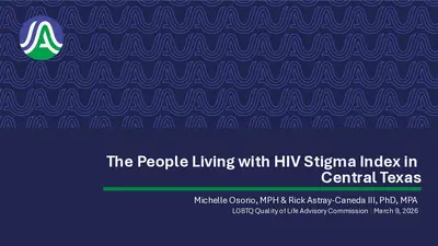
The People Living with HIV Stigma Index in Central Texas Michelle Osorio, MPH & Rick Astray-Caneda III, PhD, MPA LGBTQ Quality of Life Advisory Commission | March 9, 2026 What is stigma? • Negative attitude or idea about a mental, physical, or social feature of a person or group of people that implies social disapproval • Stigma → attitudes and perceptions • Discrimination → actions and behaviors • HIV stigma is negative attitudes and beliefs about people with HIV • Can lead to discrimination, treating people with HIV differently than those without HIV • Affects people’s health and wellbeing, and discourages people from engaging in HIV testing, prevention, and care • Violates the human rights of people living with HIV 2 PLHIV Stigma Index in Central Texas • In-person, interview-based assessment to gather evidence on how stigma and discrimination impacts the lives of people living with HIV • Created by global networks of PLHIV with backing from UNAIDS and Johns Hopkins University • Standardized tool • Covers disclosure; experience of stigma and discrimination; internalized stigma and resilience; interactions with healthcare services; and human rights and affecting change • Questions added about housing, experiences with providers, and what can be done to stop stigma in our community • 100+ countries have completed the study, 100,000+ PLHIV have been interviewed Interviewers and participants (interviewees) are PLHIV • Interviewers receive $125, participants receive $100 Interview takes approximately 60-90 minutes Interviews offered in English and Spanish • • • 3 Methods: Phase 1 • Total sample size: 336* divided into two phases • Venue-based & referral-based sampling • Priority populations: • Gay men and other MSM • Sex workers • Transgender persons • People who use drugs • People experiencing homelessness • All gender identities and sexual orientations may participate • Main inclusion criteria: aware of HIV+ diagnosis for 12 months or longer & 18 years of age or older • Recruitment via social media campaign, strategic alliances with local ASOs, community partnerships, tabling events Number of PLHIV to be interviewed Bastrop Caldwell Hays Travis Williamson 10 10 10 60 12 Phase 1 Total 102 4 What will we learn? This study will guide us to have… Which will help us to address stigma by: • A clearer picture of HIV-related stigma and discrimination and its impacts • Detailed information by county • Detailed information by race, sex, ethnicity, and gender* • Informing development …
. RECOMMENDATION TO COUNCIL LGBTQ Quality of Life Advisory Commission Recommendation Number: 20260309-008: LGBTQ Legal Navigation and Community Safety Coordination WHEREAS, LGBTQIA+ residents in Texas increasingly face confusion and risk due to evolving state policies and administrative requirements related to identity documents, civil rights protections, and access to services; and WHEREAS, timely access to accurate education, navigation support, and trusted referrals can prevent avoidable crises that may lead to housing instability, employment disruption, and disconnection from essential services; and WHEREAS, community stakeholders have identified a need for practical assistance including support with name and gender marker changes, tenant and workplace rights navigation, and connections to trusted nonprofit service providers; and WHEREAS, LGBTQIA+ residents and visitors continue to report concerns about safety, harassment, and accessibility in public spaces, particularly during major community events and peak nightlife hours; and WHEREAS, community-based, non-enforcement safety strategies such as de-escalation training, bystander intervention, and coordinated safe-walk partnerships can reduce harm and strengthen community confidence; and WHEREAS, the City of Austin Equity Office and Human Rights Division are positioned to coordinate civil rights education, community navigation, and harm-prevention programming across City departments and community partners; and WHEREAS, the LGBTQIA+ Quality of Life Commission has identified coordinated legal navigation and community safety infrastructure as one of its highest priorities for the year; NOW, THEREFORE, BE IT RESOLVED that the LGBTQIA+ Quality of Life Commission recommends that the Austin City Council direct the City Manager to establish a pilot LGBTQ Legal Navigation and Community Safety Coordination Program. BE IT FURTHER RESOLVED that the Commission recommends the creation of one full-time equivalent (FTE) LGBTQ Program Administrator or Manager position to lead, coordinate, and implement this program, and that this role be housed within the City’s Equity Office for cross- departmental coordination and community alignment. . BE IT FURTHER RESOLVED that the responsibilities of this role include coordinating City services, supporting community education, facilitating navigation and referral pathways, and working in partnership with nonprofit and community-based organizations that provide related services. BE IT FURTHER RESOLVED that program activities may include: • Know-your-rights education and informational materials • Legal navigation and referral support, including assistance related to name and gender marker changes • Tenant, employment, and civil rights navigation resources • De-escalation and bystander intervention training • Coordination of community-based safety efforts such as safe-walk partnerships during major events and peak activity periods BE IT FURTHER RESOLVED that the Commission recommends …
. RECOMMENDATION TO COUNCIL LGBTQ Quality of Life Advisory Commission Recommendation Number: 20260309-009: Expansion of MPox, STI, and Vaccination Programs WHEREAS, the City of Austin has recognized the importance of integrated vaccination and prevention programs, including Hepatitis and Flu outreach, as essential components of LGBTQIA+ public health efforts; and WHEREAS, Austin health departments and community health centers serving LGBTQIA+ residents, including community-based clinics and nonprofit providers, have demonstrated strong capacity and effectiveness in delivering culturally competent vaccination and prevention services; and WHEREAS, MPox continues to present an ongoing public health concern, particularly for LGBTQIA+ communities, and requires sustained vaccination, education, and outreach efforts rather than one-time emergency responses; and WHEREAS, recent reductions in federal and Centers for Disease Control and Prevention (CDC) public health funding have placed increased pressure on local governments to maintain continuity of vaccination, STI, and HIV prevention programs; and WHEREAS, expanded local funding would support not only MPox vaccination efforts, but also broader STI and HIV prevention services that are critical to reducing long-term public health costs and preventing outbreaks; and WHEREAS, ensuring access to timely, accurate, and culturally competent preventive healthcare improves community health outcomes and reduces strain on emergency and acute care systems; NOW, THEREFORE, BE IT RESOLVED that the LGBTQIA+ Quality of Life Commission recommends that the Austin City Council approve an increase of $80,000 in funding to Austin health departments to expand MPox vaccination, STI prevention, and HIV prevention programs targeting at-risk and underserved populations. BE IT FURTHER RESOLVED that the expanded funding should support outreach, education, vaccination access, and prevention services delivered through trusted community-based providers and public health partners serving the LGBTQIA+ community. Date of Approval: Seconded By: . Motioned By: Vote: For: Against: Abstain: Off the dais: Absent: Attest: _____________________________________________ Ryan Sperling, LGBTQ Quality of Life Advisory Commission Staff Liaison
. RECOMMENDATION TO COUNCIL LGBTQ Quality of Life Advisory Commission Recommendation Number: 20260309-011: Housing Assistance Grants for LGBTQIA+ and Queer Artists WHEREAS, Austin’s artists and creative workers are central to the City’s cultural identity, economic vitality, and national reputation as a center for live performance and creative expression; and WHEREAS, LGBTQIA+ and queer artists, including drag performers and nightlife creatives, contribute significantly to Austin’s arts and entertainment ecosystem while often facing heightened economic precarity, housing instability, and displacement pressures; and WHEREAS, rising housing costs continue to disproportionately impact artists and cultural workers, threatening the sustainability of Austin’s creative communities and cultural districts; and WHEREAS, housing instability among artists may result in the loss of culturally significant venues, performances, and creative spaces that contribute to neighborhood vitality, tourism, and small business activity; and WHEREAS, Austin Arts, Culture, Music, and Entertainment (AACME), in coordination with housing and community development departments, provides existing infrastructure for arts support and community stabilization efforts; NOW, THEREFORE, BE IT RESOLVED that the LGBTQIA+ Quality of Life Commission recommends that the Austin City Council direct the City Manager to increase funding for existing housing stabilization and assistance programs by $200,000, with coordination through AACME and relevant housing departments to ensure effective outreach to artists and creative workers. BE IT FURTHER RESOLVED that the Commission recommends that, within the administration of expanded housing stabilization resources, outreach and prioritization strategies be developed to address the documented housing instability faced by LGBTQIA+ artists and creative workers, consistent with equity-focused implementation practices and existing City guidelines. BE IT FURTHER RESOLVED that the City coordinate with AACME and community partners to ensure accessible communication, culturally competent outreach, and clear application pathways for artists and creative workers who may not traditionally access housing assistance programs. BE IT FINALLY RESOLVED that the Commission requests reporting on utilization rates, artist participation, and displacement prevention outcomes associated with the expanded funding allocation to inform future cultural and housing policy decisions. . Date of Approval: March 9, 2026 Motioned By: Commissioner Brown Seconded By: Commissioner Pituk Vote: 9-0 For: Chair Coyne, Vice Chair McLeod, Secretary Benson, Commissioners Brown, Davis, Fierro- Pérez, Knutson, Pituk, Rivas Against: None Abstain: None Off the dais: None Absent: Commissioners Bandit, Johnson, Krueger, Neal Attest: _____________________________________________ (Ryan Sperling, Staff Liaison)
. RECOMMENDATION TO COUNCIL LGBTQ Quality of Life Advisory Commission Recommendation Number: 20260309-008: LGBTQ Legal Navigation and Community Safety Coordination WHEREAS, LGBTQIA+ residents in Texas increasingly face confusion and risk due to evolving state policies and administrative requirements related to identity documents, civil rights protections, and access to services; and WHEREAS, timely access to accurate education, navigation support, and trusted referrals can prevent avoidable crises that may lead to housing instability, employment disruption, and disconnection from essential services; and WHEREAS, community stakeholders have identified a need for practical assistance including support with name and gender marker changes, tenant and workplace rights navigation, and connections to trusted nonprofit service providers; and WHEREAS, LGBTQIA+ residents and visitors continue to report concerns about safety, harassment, and accessibility in public spaces, particularly during major community events and peak nightlife hours; and WHEREAS, community-based, non-enforcement safety strategies such as de-escalation training, bystander intervention, and coordinated safe-walk partnerships can reduce harm and strengthen community confidence; and WHEREAS, the City of Austin Equity Office and Human Rights Division are positioned to coordinate civil rights education, community navigation, and harm-prevention programming across City departments and community partners; and WHEREAS, the LGBTQIA+ Quality of Life Commission has identified coordinated legal navigation and community safety infrastructure as one of its highest priorities for the year; NOW, THEREFORE, BE IT RESOLVED that the LGBTQIA+ Quality of Life Commission recommends that the Austin City Council direct the City Manager to establish a pilot LGBTQ Legal Navigation and Community Safety Coordination Program. BE IT FURTHER RESOLVED that the Commission recommends the creation of one full-time employee (FTE) LGBTQ Program Administrator or Manager position to lead, coordinate, and implement this program, and that this role be housed within the City’s Equity Office for cross- departmental coordination and community alignment. BE IT FURTHER RESOLVED that this FTE would be the direct point of contact at City of Austin for the LGBTQ+ community to include responsibilities coordinating City services, supporting . community education, facilitating navigation & referral pathways, and working with nonprofit and community-based organizations that provide related services. BE IT FURTHER RESOLVED that program activities may include: • Know-your-rights education and informational materials • Legal navigation and referral support, including assistance related to name and gender marker changes • Tenant, employment, and civil rights navigation resources • De-escalation and bystander intervention training • Coordination of community-based safety efforts such as safe-walk partnerships during major events …
. RECOMMENDATION TO COUNCIL LGBTQ Quality of Life Advisory Commission Recommendation Number: 20260309-009: Expansion of MPox, STI, and Vaccination Programs WHEREAS, the City of Austin has recognized the importance of integrated vaccination and prevention programs, including Hepatitis and Flu outreach, as essential components of LGBTQIA+ public health efforts; and WHEREAS, the City of Austin has sustained the loss of $800,000 in funding for HIV, STI, and Mpox through 2025-2026 fiscal planning, and a failed city Tax Rate Election has further resulted in a loss of funding; and WHEREAS, community partners have reached out to the LGBTQ+ Quality of Life Advisory Commission expressing grave concern regarding the loss of federal, state, and city funding, which impacts vital health partners such as the KIND Clinic and other community providers that have relied on this city funding in previous years; and WHEREAS, Austin health departments and community health centers serving LGBTQIA+ residents, including community-based clinics and nonprofit providers, have demonstrated strong capacity and effectiveness in delivering culturally competent vaccination and prevention services; and WHEREAS, MPox continues to present an ongoing public health concern, particularly for LGBTQIA+ communities, and requires sustained vaccination, education, and outreach efforts rather than one-time emergency responses; and WHEREAS, recent reductions in federal and Centers for Disease Control and Prevention (CDC) public health funding have placed increased pressure on local governments to maintain continuity of vaccination, STI, and HIV prevention programs; and WHEREAS, expanded local funding would support not only MPox vaccination efforts, but also broader STI and HIV prevention services that are critical to reducing long-term public health costs and preventing outbreaks; and WHEREAS, ensuring access to timely, accurate, and culturally competent preventive healthcare improves community health outcomes and reduces strain on emergency and acute care systems; NOW, THEREFORE, BE IT RESOLVED that the LGBTQ+ Quality of Life Advisory Commission recommends that the Austin City Council approve an increase of up to $100,000 in funding to Austin Public Health to expand Mpox vaccination, STI prevention, and HIV prevention programs targeting at-risk and underserved populations. . BE IT FURTHER RESOLVED that the expanded funding should support outreach, education, vaccination access, and prevention services delivered through trusted community-based providers and public health partners serving the LGBTQIA+ community. BE IT FURTHER RESOLVED BE IT FURTHER RESOLVED that the City of Austin should restore the loss of $800,000 in general Health and Mental services funding from last year's fiscal budget as referenced in …
. RECOMMENDATION TO COUNCIL LGBTQ Quality of Life Commission Recommendation Number: 20260309-010: Safe and Proud Austin Entertainment Corridor Life Safety Pilot Package WHEREAS, LGBTQIA+ establishments and entertainment venues have been repeatedly targeted in acts of mass violence across the United States, including the 2016 attack at Pulse Nightclub in Orlando, Florida, which resulted in 49 fatalities, and the 2022 attack at Club Q in Colorado Springs, Colorado, which resulted in five fatalities and numerous injuries; and WHEREAS, federal and national law enforcement assessments have identified LGBTQIA+ gathering spaces as recurring targets of ideologically motivated violence; and WHEREAS, following the New Orleans Mardi Gras vehicle attack, the City of Austin moved rapidly to implement protective safety measures within the Sixth Street Entertainment District to mitigate risk in a high density corridor; and WHEREAS, it has now been more than one year since that incident, and recent violence on March 1 within proximity to Bettie Naylor Street demonstrates that high density LGBTQIA+ cultural corridors in Austin face comparable risk exposure; and WHEREAS, Bettie Naylor Street, historically recognized as Fourth Street between Congress Avenue and Rio Grande Street, serves as Austin's primary LGBTQIA+ cultural corridor and functions as a concentration of bars, coffee shops, entertainment venues, and affirming small businesses that draw high pedestrian volumes; and WHEREAS, adjacent affirming businesses on Lavaca Street and Colorado Street, including establishments such as The Iron Bear and Highland, are integral components of this corridor ecosystem and lie within close proximity to recent public safety incidents; and WHEREAS, consistency in public safety infrastructure deployment across entertainment districts is essential to equitable risk mitigation, municipal resilience, and liability management; and WHEREAS, targeted deployment based on documented risk exposure, concentration of historically targeted establishments, and proximity to recent violent incidents represents a tiered and defensible public safety approach; and WHEREAS, rapid intervention during the first minutes of a life threatening emergency, including severe bleeding events and sudden cardiac arrest, significantly increases survival outcomes; and . WHEREAS, public safety best practices emphasize layered mitigation strategies including early notification, immediate hemorrhage control, defibrillation access, community CPR activation, and coordinated emergency response; and WHEREAS, the Austin Travis County EMS Chief Medical Officer requested funding for Community CPR Alerting and AED Deployment to Enhance Equity, including investment in the GoodSAM platform to improve cardiac arrest outcomes through real time scene awareness and verified responders, and alignment with this corridor safety pilot would strengthen …
. RECOMMENDATION TO COUNCIL LGBTQ Quality of Life Advisory Commission Recommendation Number: 20260309-012: Community Liaison Officer Program Pilot WHEREAS, the City of Austin has committed to community-centered public safety strategies that prioritize trust-building, accessibility, and culturally competent engagement with historically marginalized communities, including LGBTQIA+ residents; and WHEREAS, the LGBTQIA+ Quality of Life Commission, the Joint Inclusion Committee, and other City commissions have received consistent feedback from community members regarding the need for improved communication, responsiveness, and accountability in interactions with law enforcement; and WHEREAS, the City of Austin and Austin Police Department have previously endorsed the Community Liaison Officer Expansion and Empowerment framework, which calls for strengthening and formalizing the Community Liaison function as a core community engagement strategy; and WHEREAS, Austin Police Department currently maintains liaison functions, and a pilot model incorporating both civilian coordination and sworn, uniformed officers may strengthen visibility, accessibility, and community trust; and WHEREAS, leadership within APD has indicated that initial implementation can be achieved primarily through internal realignment of existing personnel and currently vacant positions, without requiring a significant increase in overall staffing levels; and WHEREAS, successful implementation depends on assigning experienced and community- connected personnel, prioritizing liaison responsibilities within departmental operations, and establishing clear procedures, training, and data practices to support long-term program effectiveness; and WHEREAS, a phased pilot approach allows the City to evaluate effectiveness, community impact, and operational needs before considering broader expansion or long-term funding commitments; NOW, THEREFORE, BE IT RESOLVED that the LGBTQIA+ Quality of Life Commission recommends that the Austin City Council direct the City Manager to allocate Phase One pilot funding to support initial implementation of the Community Liaison Officer Program Pilot. BE IT FURTHER RESOLVED that the pilot model include both civilian coordination support and sworn, uniformed APD Community Liaison Officers, utilizing experienced personnel where feasible, with an emphasis on individuals who maintain established relationships with LGBTQIA+ and historically marginalized communities. . BE IT FURTHER RESOLVED that the Austin Police Department establish internal procedures to prioritize liaison responsibilities within assigned duties, ensuring sworn officers participating in the pilot are able to consistently fulfill community engagement, outreach, and responsiveness commitments associated with the role. BE IT FURTHER RESOLVED that Phase One pilot funding support the following limited and targeted activities: • Designation and operational support of sworn LGBTQIA+ Community Liaison Officers utilizing existing APD personnel where feasible • Initial training and professional development related to cultural competency, …
. RECOMMENDATION TO COUNCIL LGBTQ Quality of Life Advisory Commission Recommendation Number: 20260309-014: Entrepreneurial Grants for LGBTQIA+ Businesses WHEREAS, local LGBTQIA+-owned businesses contribute significantly to Austin’s cultural identity, neighborhood character, tourism appeal, and economic vitality; and WHEREAS, small businesses owned by LGBTQIA+ entrepreneurs may face barriers to accessing capital and business development resources, particularly during periods of economic uncertainty and rising operating costs; and WHEREAS, City initiatives supporting historically underserved entrepreneurs have demonstrated success in fostering business stability, local job creation, and neighborhood economic resilience; and WHEREAS, responsible tools such as no-interest loans, technical assistance, and targeted entrepreneurial support can strengthen small business sustainability while maintaining fiscal prudence; and WHEREAS, continued and expanded support for LGBTQIA+ entrepreneurs aligns with the City’s commitments to inclusive economic development, small business resilience, and cultural district preservation; NOW, THEREFORE, BE IT RESOLVED that the LGBTQIA+ Quality of Life Commission recommends that the Austin City Council expand and continue entrepreneurial support initiatives within existing City economic development programs to strengthen access to capital and technical assistance for LGBTQIA+ entrepreneurs. BE IT FURTHER RESOLVED that the Commission recommends allocating $200,000 to enhance no- interest loan capacity and related entrepreneurial assistance within the City’s existing small business support infrastructure. BE IT FURTHER RESOLVED that program implementation include targeted outreach and culturally competent engagement to ensure equitable access for LGBTQIA+ owned businesses, particularly small, locally owned, and community-serving enterprises that may face barriers to traditional financing. BE IT FINALLY RESOLVED that the Commission requests reporting on participation rates, loan performance, and business stabilization outcomes to evaluate program impact and inform future economic development strategies. . Date of Approval: March 9, 2026 Motioned By: Commissioner Brown Seconded By: Commissioner Knutson Vote: 9-0 For: Chair Coyne, Vice Chair McLeod, Secretary Benson, Commissioners Brown, Davis, Fierro- Pérez, Knutson, Pituk, Rivas Against: None Abstain: None Off the dais: None Absent: Commissioners Bandit, Johnson, Krueger, Neal Attest: _____________________________________________ (Ryan Sperling, Staff Liaison)
. RECOMMENDATION TO COUNCIL LGBTQ Quality of Life Advisory Commission Recommendation Number: 20260309-015: LGBTQ Entertainment District WHEREAS, the State of Texas, through directives to enforce roadway safety and pavement marking compliance, has required removal of decorative and message-based roadway art, including rainbow and culturally themed crosswalks, with potential risk to transportation funding for noncompliance; and WHEREAS, the rainbow crosswalk at West 4th Street and Colorado Street has served as a widely recognized marker of Austin’s LGBTQ cultural and entertainment district, signaling safety, belonging, and civic recognition for LGBTQIA+ residents and visitors; and WHEREAS, the removal of highly visible cultural markers in public spaces may negatively affect community cohesion, cultural tourism, and small business activity within established neighborhood corridors; and WHEREAS, the City of Austin operates a Street Banner Program that provides a lawful and compliant framework for district identity markers, including over-street and street-pole banners, consistent with roadway regulations; and WHEREAS, the development of an LGBTQ Entertainment District, supported by culturally identifiable infrastructure, may strengthen economic activity, tourism, and small business vitality within the district; and WHEREAS, exploration of a Micro Public Improvement District (Micro-PID) or similar localized funding and maintenance structure may provide a sustainable mechanism for district identity infrastructure, programming, and long-term stewardship; and WHEREAS, community-centered public art and engagement processes improve representation, legitimacy, and long-term community ownership of civic cultural markers; and WHEREAS, timely execution of a compliant transition strategy is necessary to meet state- mandated deadlines and minimize disruption to community identity, tourism, and district economic activity; and WHEREAS, this effort aligns with the work of the Mayor’s Task Force on transitioning from decorative crosswalks to compliant public-space district markers and identity infrastructure; NOW, THEREFORE, BE IT RESOLVED that the LGBTQIA+ Quality of Life Commission recommends that the Austin City Council direct the City Manager to prioritize and establish a one-time LGBTQ . Entertainment District Cultural Infrastructure Pilot to replace removed decorative crosswalk markers with compliant district identifiers, including banners, flags, wayfinding elements, and related identity infrastructure, with an initial focus on the West 4th Street corridor. BE IT FURTHER RESOLVED that the Commission recommends allocating $120,000 in one-time funding for design, fabrication, and installation of district identity infrastructure, utilizing the City’s existing Street Banner Program and related standards where feasible. BE IT FURTHER RESOLVED that the pilot include a structured community engagement and local artist process to develop culturally authentic district marker designs reflective of …
LGBTQ QUALITY OF LIFE ADVISORY COMMISSION MINUTES REGULAR MEETING Wednesday, March 9, 2026 The LGBTQ Quality of Life Advisory Commission convened in a regular meeting on Monday, March 9, 2026 at 6:30 PM at the Permitting and Development Center, 6310 Wilhelmina Delco Dr., Austin, TX, Room #1406 Commissioners in attendance in person: KC Coyne (Chair) Jerry Joe Benson (Secretary) Garry Brown Asher Knutson Randy Pituk Steven Rivas Commissioners in attendance remotely: Kitty McLeod (Vice Chair) Morgan Davis Rocio Fierro-Perez Chair Coyne called the meeting to order at 6:40 p.m. PUBLIC COMMUNICATION: GENERAL Tamara Hoover – Cheer up Charlies APPROVAL OF MINUTES 1. Approve the minutes of the LGBTQ Quality of Life Advisory Commission regular meeting of February 9, 2026. The February 9, 2026 minutes were approved on Secretary Benson’s motion, Commissioner Brown’s second on a 9-0 vote. Commissioners Bandit, Johnson, Krueger, and Neal were absent. DISCUSSION ITEMS 2. 3. 4. 5. 6. Presentation regarding the PHLIV Stigma Index and an HIV Resource Guide. Presentation by Michelle Osorio, Public Health Program Coordinator, Austin Public Health and Rick Astray-Caneda III, President, Friends of the David Powell Clinic. The presentation was made by Michelle Osorio, Public Health Program Coordinator, Austin Public Health and Rick Astray-Caneda III, President, Friends of the David Powell Clinic. Presentation by Austin Pride to provide a high-level update and coordination conversation focused on early planning and alignment for 2026 Austin PRIDE. Presentation by Micah Andress, President, Austin PRIDE. The presentation was made by Micah Andress, President, Austin PRIDE. The meeting went into recess without objection at 7:48 p.m. The meeting was called back to order at 8:01 p.m. Discussion regarding a priority list for which organizations to invite to present at commission meetings. Discussion was held. Discussion regarding a view-only folder for commissioner resources. Discussion was held. Discussion regarding potential collaboration with the LGBTQ Chamber of Commerce. Discussion was held. WORKING GROUP RECOMMENDATIONS 7. Report from the FY2026-27 Budget Working Group regarding its proposed budget recommendations. The report was provided by Secretary Benson. DISCUSSION AND ACTION ITEMS 8. Approve a budget recommendation for LGBTQ legal navigation and community safety coordination. This item was postponed to later in the meeting without objection on Chair Coyne’s motion. Item 8 was taken up after Item 15. The recommendation for LGBTQ legal navigation and community safety coordination was approved with the below amendments on Secretary Benson’s motion, Commissioner Rivas’ second on a 9-0 …
MEETING OF THE ELECTRIC UTILITY COMMISSION March 9, 2026 ▪ 6:00 PM AUSTIN ENERGY HEADQUARTERS/SHUDDE FATH CONFERENCE ROOM 4815 MUELLER BLVD AUSTIN, TEXAS Some members of the Electric Utility Commission maybe participating by videoconference. The meeting may be viewed online at: http://www.austintexas.gov/page/watch-atxn-live Public comment will be allowed in-person or remotely by telephone. Speakers may only register to speak on an item once either in-person or remotely and will be allowed up to three minutes to provide their comments. Registration no later than noon the day before the meeting is required for remote participation. To register to speak remotely, contact Nici Huff, at Nici.Huff@AustinEnergy.com or via phone at 512-972-8621. Members: Dave Tuttle, Chair Kaiba White, Vice Chair Raul Alvarez Lauren Bellomy CALL TO ORDER Cesar Benavides Jonathon Blackburn Al Braden Chris Gillett AGENDA Chris Kirksey Cyrus Reed Joshua Rhodes PUBLIC COMMUNICATION: GENERAL The first 5 speakers signed up prior to the meeting being called to order will each be allowed a three- minute allotment to address their concerns regarding items not posted on the agenda. APPROVAL OF MINUTES 1. Approve the minutes of the Electric Utility Commission Regular Called Meeting on February 9, 2026. DISCUSSION AND ACTION ITEMS 2. Recommend approval authorizing a contract for strategic consulting services for Austin Energy with Rifeline, LLC, for a term of three years in an amount not to exceed $450,000. Funding: $150,000 is available in the Operating Budget of Austin Energy. Funding for the remaining contract term is contingent upon available funding in future budgets. 3. Recommend approval authorizing an amendment to a contract for continued Autodesk solutions suite for Austin Energy with DLT Solutions, LLC, to increase the amount by $500,000 and to extend the term by one year for a revised total contract amount not to exceed $2,200,000. Funding: $500,000 is available in the Operating Budget of Austin Energy. 4. Recommend approval authorizing a contract for the St. Elmo Vehicle Bays Project for Austin Energy with Noble General Contractors, LLC in the amount of $6,999,700, plus a $699,970 contingency, for a total contract amount not to exceed $7,699,670. Funding: $7,699,670 is available in the Operating Budget of Austin Energy. 5. Recommend approval authorizing a contract for maintenance, repair and replacement of electric vehicle charging stations for Austin Energy and Austin Aviation with National Car Charging, LLC for an initial term of one year with up to two one-year extension options in an …
Posting Language ..Title Authorize a contract for Ciena Dense Wavelength Division Multiplexing products and services for Austin Energy with Netsync Network Solutions, Inc., or one of the other qualified offerors, for an initial term of two years with up to three one-year extension options for a total contract amount not to exceed $2,000,000. Funding: $90,373 is available in the Operating Budget of Austin Energy and $1,000,000 is available in the Capital Budget of Austin Energy. Funding for the remaining contract term is contingent upon available funding in future budgets. ..Body Lead Department Austin Financial Services. Client Department(s) Austin Energy. Fiscal Note Funding in the amount of $90,373 is available in the Fiscal Year 2025-2026 Operating Budget of Austin Energy. Funding in the amount of $1,000,000 is available in the Capital Budget of Austin Energy. Funding for the remaining contract term is contingent upon available funding in future budgets. Procurement Language: The Financial Services Department issued a Request for Proposals RFP 1100 EAL3026 for these goods and services. The solicitation was published on July 28, 2025 and closed on September 16, 2025. Of the five offers received, the proposal submitted by the recommended contractor represented best value to the City based on the solicitation’s evaluation criteria. A complete solicitation package, including a log of offers received, is available for viewing on the City’s website. This information can currently be found at: https://financeonline.austintexas.gov/afo/account_services/solicitation/solicitation_details.cfm?sid=142673 . MBE/WBE: This contract will be awarded in compliance with the City Code Chapter 2-9B (Minority Owned and Women Owned Business Enterprise Procurement Program). For the goods and services required for this solicitation, there were no subcontracting opportunities; therefore, no subcontracting goals were established. For More Information: Direct questions regarding this Recommendation for Council Action to the Financial Services Department - Central Procurement at FSDCentralProcurementRCAs@austintexas.gov or 512-974-2500. Respondents to the solicitation and their Agents should direct all questions to the Authorized Contact Person identified in the solicitation. Council Committee, Boards and Commission Action: March 9, 2026 - To be reviewed by the Electric Utility Commission. Additional Backup Information: The contract is for Ciena Dense Wavelength Division Multiplexing (DWDM) technology. Austin Energy’s (AE) private fiber network connects many components of its critical infrastructure, including data centers, substations, and other facilities. Ciena’s DWDM technology allows the utility to significantly expand fiber capacity and deliver reliable, high-speed connectivity for critical operations such as Supervisory Control and Item 10 Data Acquisition and datacenter …
ELECTRIC UTILITY COMMISSION RECOMMENDATION Date: March 9, 2026 Subject: Recommendations on AE Budget and Potential Rate Increases Motioned By: Seconded By: Recommendation Recommendation against increasing Austin Energy rates for residential customers in FY 2027 and instead beginning a rate case process with FY 2025-26 as a test year, and recommendations for meeting certain Austin Energy Resource, Generation and Climate Protection Plan goals through the annual 26-27 budget process. Description of Recommendation to Council The Electric Utility Commission recommends that further increases in residential rates, including to the fixed monthly charge, should be handled through a rate case, similar to the one implemented in 2022. Austin City Council should begin Austin Energy’s rate case process in 2026 to better keep Austin Energy budgets aligned with costs, while ensuring that rates are justified for all customer classes and that rate design aligns with established policy priorities. As a first step, Austin Energy should conduct an assessment of its costs and revenues, using 2025 as a test case year. The City Council should direct the City Manager to initiate the process of hiring a consumer advocate to represent residential customers in the rate case and should initiate the hiring of an independent hearing examiner to preside over the rate case. In addition, the Electric Utility Commission recommends that City Council ensure there is sufficient staff and programmatic money allocated in the Austin Energy budget to meet the goals established in the Austin Energy Resource, Generation and Climate Protection Plan to 2035, approved by the city council in 2024. Specifically, the FY 2027 budget should ensure that Austin Energy remains or gets on pace to meet its goals related to energy efficiency, local solar, local storage, renewable energy and transmission upgrades to increase its import capacity. Rationale: Austin Energy has an important mission to serve its customers with affordable, clean and reliable energy. The FY 2027 budget and tariffs should maintain the affordable rates approved by City Council in late 2022 and preserve the basic tenets of the rate design approved. In addition, City Council has adopted an ambitious but achievable Resource, Generation and Climate Protection Plan and the budget should reflect that plan. 1 of 3 Item 11 20260309-011 The appropriate amount for the monthly Customer Charge for residential customers and the price differentiation between the residential rate tires were hotly contested issues in the last Austin Energy rate case, in 2022. Austin …
Posting Language ..Title Authorize a contract for strategic consulting services for Austin Energy with Rifeline, LLC, for a term of three years in an amount not to exceed $450,000. Funding: $150,000 is available in the Operating Budget of Austin Energy. Funding for the remaining contract term is contingent upon available funding in future budgets. ..Body Lead Department Austin Financial Services. Client Department(s) Austin Energy. Fiscal Note Funding in the amount of $150,000 is available in the Fiscal Year 2025-2026 Operating Budget of Austin Energy. Funding for the remaining contract term is contingent upon available funding in future budgets. Procurement Language: Professional Services. MBE/WBE: This solicitation was reviewed for subcontracting opportunities in accordance with City Code Chapter 2-9B (Minority-Owned and Women-Owned Business Enterprise Procurement Program); For the services required for this solicitation, there were no subcontracting opportunities; therefore, no subcontracting goals were established. For More Information: Direct questions regarding this Recommendation for Council Action to Austin Financial Services - Central Procurement at FSDCentralProcurementRCAs@austintexas.gov or 512-974-2500. Council Committee, Boards and Commission Action: March 9, 2026 - To be reviewed by the Electric Utility Commission. Additional Backup Information: This contract will provide a range of professional consulting services in support of Austin Energy’s strategic, mission-driven initiatives that benefit from public involvement, community engagement, and information sharing. Rifeline, LLC provides expertise for services including community outreach planning and execution; stakeholder identification, mapping and engagement; key messaging and strategic communications development; and facilitation of public meetings, workshops and listening sessions. The selected contractor has provided strategic services leading up to the adoption of Austin Energy’s Resource, Generation and Climate Protection Plan to 2035 and Electric System Resiliency Plan. Under this contract, Rifeline, LLC will continue to provide expertise and knowledge in support of key efforts that enhance Austin Energy’s work in alignment with community values. Rifeline’s focus on community engagement through informed consent serves as a model that listens to the community and shapes Austin Energy’s work as a result. Item 2 This contract is essential to ensure meaningful public engagement and incorporate community feedback into Austin Energy’s strategic work. Without this contract, Austin Energy would lack the tools and expertise needed to gather, analyze, and integrate customer input, resulting in initiatives that may not fully reflect community priorities.
Posting Language ..Title Authorize an amendment to a contract for continued Autodesk solutions suite for Austin Energy with DLT Solutions, LLC, to increase the amount by $500,000 and to extend the term by one year for a revised total contract amount not to exceed $2,200,000. Funding: $500,000 is available in the Operating Budget of Austin Energy. ..Body Lead Department Austin Financial Services. Client Department(s) Austin Energy. Fiscal Note Funding in the amount of $500,000 is available in the Fiscal Year 2025-2026 Operating Budget of Austin Energy. Procurement Language: Contract Amendment. MBE/WBE: This contract is exempt from the City Code Chapter 2-9B (Minority-Owned and Women-Owned Business Enterprise Procurement Program); therefore, no subcontracting goals were established. Prior Council Action: June 3, 2021 - Council approved a contract for Autodesk solutions suite with DLT Solutions, LLC. For More Information: Direct questions regarding this Recommendation for Council Action to Austin Financial Services - Central Procurement at FSDCentralProcurementRCAs@austintexas.gov or 512-974-2500. Council Committee, Boards and Commission Action: March 9, 2026 - To be reviewed by the Electric Utility Commission. Additional Backup Information: The contract provides Autodesk AutoCAD, Vault Pro Utilities, ProductivityNow, and IMAGINiT licenses and services for Austin Energy. AutoCAD is a digital blueprint tool used by Austin Energy engineers to design power grids, substations, and other infrastructure designs. It enables precise, scalable, and easily shareable designs for critical utility projects. Vault Pro Utilities is a data management solution that securely stores and organizes computer-aided drafting design files. It supports collaboration by allowing multiple teams to access and share designs while maintaining version controls, tracking changes, and enforcing security permissions for sensitive utility data. ProductivityNow and IMAGINiT provide on-demand training, expert support, and optimize workflow for Autodesk tools. Bundling these tools and services under one contract is essential for maintaining a connected design and data management environment. This approach ensures compatibility and provides a scalable foundation for future system upgrades. An additional year and increased authorization on the current contract is necessary while a new multi-year contract is negotiated. Item 3 Contract Details: Contract Term Length of Term Initial Term Proposed Amendment Total 5 years 1 year 6 years Contract Authorization Requested Additional Authorization Revised Total Authorization $1,700,000 $1,700,000 $500,000 $500,000 $1,700,000 $500,000 $2,200,000 Note: Contract Authorization amounts are based on the City’s estimated annual usage.
Posting Language ..Title Authorize a contract for construction services for the St. Elmo Vehicle Bays Project for Austin Energy with Noble General Contractors, LLC in the amount of $6,999,700, plus a $699,970 contingency, for a total contract amount not to exceed $7,699,670. Funding: $7,699,670 is available in the Operating Budget of Austin Energy. ..Body Lead Department Austin Financial Services. Managing Department Austin Energy. Fiscal Note $7,699,670 is available in the Fiscal Year 2025-2026 Operating Budget of Austin Energy. Procurement Language: Austin Financial Services issued an Invitation for Bids solicitation IFB 6100 CLMC1022 for these services. The solicitation was issued on September 8, 2025, and closed on December 4, 2025. Of the four bids received, the bids submitted by the recommended contractor was the lowest responsive bids received. A complete solicitation package, including a tabulation of the bids received, is available for viewing on the City’s website. This information can currently be found at https://financeonline.austintexas.gov/afo/account_services/solicitation/solicitation_details.cfm?sid=139493. MBE / WBE: This contract will be awarded in compliance with City Code Chapter 2-9A (Minority-Owned and Women- Owned Business Enterprise Procurement Program) by meeting the goals with 17.77% MBE and 4.29% WBE participation. For More Information: Direct questions regarding this Recommendation for Council Action to Austin Financial Services - Central Procurement at FSDCentralProcurementRCAs@austintexas.gov or 512-974-2500. Respondents to the solicitation and their Agents should direct all questions to the Authorized Contact Person identified in the solicitation. Council Committee, Boards and Commission Action: February 9, 2026 - To be reviewed by the Electric Utility Commission. Additional Backup Information: This project will construct five covered vehicle bays and storage facilities for the St. Elmo Service Center. The St. Elmo Service Center currently has Austin Energy vehicles and equipment exposed to weather conditions, which can lead to damage and inefficiencies. To address this, a covered truck bay facility that meets Austin Energy’s operational requirements will need to be constructed. The project includes three covered bays to accommodate two bucket trucks per bay, improved loading and unloading capabilities for trucks, enhanced safety measures, improve traffic flow and space utilization and include storage for metering equipment. This project will protect valuable assets, improve efficiency, and ensure the facility meets Austin Energy’s specific needs. Due to the potential for unforeseen site conditions, a 10% contingency in funding has been included to allow for the expeditious processing of any change orders to cover any unforeseen construction costs associated Item 4 with the project. …
Posting Language ..Title Authorize a contract for maintenance, repair and replacement of electric vehicle charging stations for Austin Energy and Austin Aviation with National Car Charging, LLC for an initial term of one year with up to two one-year extension options in an amount not to exceed $900,000. Funding: $200,000 is available in the Operating Budget of Austin Energy and $60,000 is available in the Operating Budget of Austin Aviation. Funding for the remaining contract term is contingent upon available funding in future budgets. ..Body Lead Department Austin Financial Services. Client Department(s) Austin Energy and Austin Aviation. Fiscal Note Funding in the amount of $200,000 is available in the Fiscal Year 2025-2026 Operating Budget of Austin Energy. Funding in the amount of$60,000 is available in the Fiscal Year 2025-2026 Operating Budget of Austin Aviation. Funding for the remaining contract term is contingent upon available funding in future budgets. Procurement Language: Austin Financial Services issued a Request for Proposals solicitation RFP 1100 DCM3038 for these services. The solicitation was published on July 28, 2025, and closed on September 18, 2025. Of the eleven offers received, the proposal submitted by the recommended contractor represented best value to the City based on the solicitation’s evaluation criteria. A complete solicitation package, including a log of offers received, is available for viewing on the City’s website. This information can currently be found at https://financeonline.austintexas.gov/afo/account_services/solicitation/solicitation_details.cfm?sid=142601 . MBE/WBE: This contract will be awarded in compliance with the City Code Chapter 2-9B (Minority-Owned and Women- Owned Business Enterprise Procurement Program). For the service required for this solicitation, there were no subcontracting opportunities therefore, no subcontracting goals were established. For More Information: Direct questions regarding this Recommendation for Council Action to the Austin Financial Services - Central Procurement at FSDCentralProcurementRCAs@austintexas.gov or 512-974-2500. Respondents to the solicitation and their Agents should direct all questions to the Authorized Contact Person identified in the solicitation. Council Committee, Boards and Commission Action: March 9, 2026 - To be reviewed by the Electric Utility Commission. Additional Backup Information: The contract will provide maintenance, replacement, and repair of all current and future electric vehicle charging stations in the Austin Energy Plug-In EVerywhere™ network and at Austin-Bergstrom International Airport. Services include preventative and standard maintenance, including emergency repair services and will ensure the electric vehicle charging stations continue to provide reliable energy and excellent Item 5 customer service to electric vehicle drivers. The contract replaces a …
Posting Language ..Title Authorize a contract for transformer bushings for Austin Energy with Wesco Distribution, Inc., d/b/a Hi- Line Utility Supply Co, LLC or Power Supply Inc., for an initial term of two years with up to three one-year extension options in an amount not to exceed $1,000,000. Funding: $10,000 is available in the Capital Budget and $90,000 is available in the Operating Budget of Austin Energy. Funding for the remaining contract term is contingent upon available funding in future budgets. ..Body Lead Department Austin Financial Services. Client Department(s) Austin Energy. Fiscal Note Funding in the amount of $10,000 is available in the Capital Budget of Austin Energy. Funding in the amount of $90,000 is available in the Fiscal Year 2025-2026 Operating Budget of Austin Energy. Funding for the remaining contract term is contingent upon available funding in future budgets. Procurement Language: Sole Source. MBE/WBE: Sole source contracts are exempt from the City Code Chapter 2-9B (Minority-Owned and Women-Owned Business Enterprise Procurement Program); therefore, no subcontracting goals were established. For More Information: Direct questions regarding this Recommendation for Council Action to the Financial Services Department - Central Procurement at FSDCentralProcurementRCAs@austintexas.gov or 512-974-2500. Council Committee, Boards and Commission Action: March 9, 2026 - To be reviewed by the Electric Utility Commission. Additional Backup Information: The contract will provide transformer bushings for Austin Energy substation transformers across its service area. Transformer bushings provide essential insulation for high-voltage connections, safely guiding electricity through the transformer wall while preventing electrical faults that could lead to explosions, fires, or outages. ABB bushings have been the approved Austin Energy standards since 2000 which are necessary for direct replacement of existing components. All substation transformers use ABB components. Due to the compatibility requirement, a sole source contract is necessary. ABB owns the intellectual property for these parts and authorizes distribution exclusively through Wesco Distribution Inc., d/b/a Hi-Line Utility Supply Co, LLC or Power Supply Inc. This contract replaces the previous agreement with the same contractor. The requested amount is based on budget projections, operations and maintenance needs, and includes a contingency for unplanned events and price escalations. Item 6 If a contract is not approved, the City could face increased risk of extended outages due to bushing failures. Contract Details: Contract Term Initial Term Optional Extension 1 Optional Extension 2 Optional Extension 3 Total Length of Term 2 years 1 year 1 year 1 year 5 years …
Posting Language ..Title Authorize a contract for vegetation management around street lighting for Austin Energy with Wright Tree Service, Inc., or one of the other qualified offerors, for an initial term of three years with up to three one-year extension options in an amount not to exceed $9,000,000. Funding: $650,000 is available in the Operating Budget of Austin Energy. Funding for the remaining contract term is contingent upon available funding in future budgets. ..Body Lead Department Austin Financial Services. Client Department(s) Austin Energy. Fiscal Note Funding in the amount of $650,000 is available in the Fiscal Year 2025-2026 Operating Budget of Austin Energy. Funding for the remaining contract term is contingent upon available funding in future budgets. Procurement Language: Austin Financial Services issued a Request for Proposals solicitation RFP 1100 LLM3001 for these goods and services. The solicitation was published on August 25, 2025, and closed on September 23, 2025. Of the four offers received, the proposal submitted by the recommended contractor represented best value to the City based on the solicitation’s evaluation criteria. A complete solicitation package, including a log of offers received, is available for viewing on the City’s website. This information can currently be found at https://financeonline.austintexas.gov/afo/account_services/solicitation/solicitation_details.cfm?sid=142510 . MBE/WBE: This contract will be awarded in compliance with the City Code Chapter 2-9B (Minority-Owned and Women- Owned Business Enterprise Procurement Program). For the service required for this solicitation, there were no subcontracting opportunities; therefore, no subcontracting goals were established. For More Information: Direct questions regarding this Recommendation for Council Action to the Austin Financial Services - Central Procurement at FSDCentralProcurementRCAs@austintexas.gov or 512-974-2500. Respondents to the solicitation and their Agents should direct all questions to the Authorized Contact Person identified in the solicitation. Council Committee, Boards and Commission Action: March 9, 2026 - To be reviewed by the Electric Utility Commission. Additional Backup Information: The contract will provide vegetation management around street lighting and wires supplying power to street lighting. Services will support the vegetation management program across multiple operational areas, including capital improvement projects, distribution maintenance on circuit, grid, or substation facilities; individual customer requests; after-hours and storm restoration events; and ongoing vegetation suppression. The current contract expires April 23, 2026. The recommended contractor is the current provider of these services. Item 7 An evaluation team with expertise in this area evaluated the offers and scored Wright Tree Service, Inc. as the best to provide these services based …
Posting Language ..Title Authorize a contract for electric distribution vegetation management pre-planning services for Austin Energy with Eocene Environmental Group, or one of the other qualified offerors, for an initial term of three years with up to three one-year extension options in an amount not to exceed $24,000,000. Funding: $1,010,000 is available in the Operating Budget of Austin Energy. Funding for the remaining contract term is contingent upon available funding in future budgets. ..Body Lead Department Austin Financial Services. Client Department(s) Austin Energy. Fiscal Note Funding in the amount of $1,010,000 is available in the Fiscal Year 2025-2026 Operating Budget of Austin Energy. Funding for the remaining contract term is contingent upon available funding in future budgets. Procurement Language: Austin Financial Services issued a Request for Proposals solicitation RFP 1100 LLM3002 for these services. The solicitation was published on September 1, 2025, and closed on October 14, 2025. Of the nine offers received, the proposal submitted by the recommended contractor represented best value to the City based on the solicitation’s evaluation criteria. A complete solicitation package, including a log of offers received, is available for viewing on the City’s website. This information can currently be found at https://financeonline.austintexas.gov/afo/account_services/solicitation/solicitation_details.cfm?sid=142507 . MBE/WBE: This contract will be awarded in compliance with the City Code Chapter 2-9B (Minority-Owned and Women- Owned Business Enterprise Procurement Program). For the service required for this solicitation, there were no subcontracting opportunities; therefore, no subcontracting goals were established. For More Information: Direct questions regarding this Recommendation for Council Action to the Austin Financial Services - Central Procurement at FSDCentralProcurementRCAs@austintexas.gov or 512-974-2500. Respondents to the solicitation and their Agents should direct all questions to the Authorized Contact Person identified in the solicitation. Council Committee, Boards and Commission Action: March 9, 2026 - To be reviewed by the Electric Utility Commission. Additional Backup Information: The contract will provide pre-planning services for Austin Energy’s vegetation management around distribution electrical facilities. Pre-planning services include coordination and assignment of work to vegetation management contractors, performance of quality control audits, notification and coordination with property owners, and development of detailed vegetation management work plans. These services support capital improvement projects, distribution maintenance on circuits, grid and substation facilities, customer requests regarding outages or complaints, after-hours or storm restoration events, and vegetation suppression. Item 8 The current contract for these services will expire April 17, 2026. The recommended contractor is not the current provider of these …
Posting Language ..Title Authorize a contract for construction services for the Lady Bird Lake Bore for Pedernales Reconductor for Austin Energy with Austin Underground, Inc., in the amount of $2,733,915 plus a $273,391 contingency for a total contract amount not to exceed $3,007,306. Funding: $3,007,306 is available in the Capital Budget of Austin Energy. ..Body Lead Department Austin Financial Services. Managing Department Austin Energy. Fiscal Note Funding is available in the Capital Budget of Austin Energy. Procurement Language: ustin Financial Services issued an Invitation for Bids solicitation IFB 6100 CLMC1056 for these services. The solicitation was issued on May 13, 2024, and closed on October 2, 2025. Of the five offers received, the bids submitted by the recommended contractor were the lowest responsive bids received. A complete solicitation package, including a tabulation of the bids received, is available for viewing on the City’s website. This information can currently be found at https://financeonline.austintexas.gov/afo/account_services/solicitation/solicitation_details.cfm?sid=141090. MBE / WBE: This contract will be awarded in compliance with City Code Chapter 2-9A (Minority-Owned and Women- Owned Business Enterprise Procurement Program) by meeting the goals with 72.31% MBE and 0.15% WBE. For More Information: Direct questions regarding this Recommendation for Council Action to Austin Financial Services - Central Procurement at FSDCentralProcurementRCAs@austintexas.gov or 512-974-2500. Respondents to the solicitation and their Agents should direct all questions to the Authorized Contact Person identified in the solicitation. Council Committee, Boards and Commission Action: March 9, 2026 - To be reviewed by the Electric Utility Commission. Additional Backup Information: The Lady Bird Lake Bore for Pedernales Reconductor project is located East of Interstate 35 and crosses under Lady Bird Lake with the entry/exit points being Edward Rendon Sr. Park and Peace Point Park respectively. This project proposes an infrastructure replacement of the Austin Energy Pedernales 04 and 06 electric feeders which have reached the end of their useful lifespan. This upgrade is necessary due to the load growth along South Pleasant Valley Road and East Riverside Drive. This project will also address system stability and reliability in the region. The project itself consists of the installation of an approximately 1,400 linear foot directional bore under Lady Bird Lake. This bore will allow for an immediate upgrade of the infrastructure feeding the area, as well as providing additional spare conduits to accommodate for future growth. In addition to the bore, the entry/exit points of this project also include two electrical manholes and …
Transmission Import Capacity Critical Importance to Austin Zero Carbon 2035 Goals Al Braden Electric Utility Commission March 9, 2026 Item 12 AE Constrained By Import Capacity • Austin Energy challenged to import enough power. • Not enough import capacity to close lines to modernize and upgrade them. • Not enough in-town generation to support the line outages needed for that work either. • Peakers wouldn’t be ready till 2030 or later. • Transmission is an important tool in our toolbox. • We can build incremental transmission improvements, batteries and solar in that same time – eliminating the need for more fossil plants. AE Grid Based On Historic Gas Generation • Austin relied on in-town generation with gas and oil since 1950’s. • External transmission lines to Fayette and South Texas Project only. • Austin is limited to bringing power from the east, requiring more equipment for voltage support to the west side of Austin. • Transmission links between DFW and San Antonio run to our east – providing indirect access to our wind and solar energy. • Sister cities are encircled by energy beltways - allowing power import from many directions. • Austin’s in-town generation never required extensive transmission lines to the outside world when we were a smaller gas-powered city – until our commitment to transition to renewables a decade ago. Transmission Required to Close Gas Plants • Early wind and solar projects could be handled by the CREZ lines and our import capacity. • As renewables grew in West Texas, congestion costs and price separation became serious problems. • 2020 Generation Plan – AE argued it couldn’t meet our renewable goals and retire our gas plants without additional transmission lines. • Closing the Decker steam units in 2022-2023 left a 700 MW local generation gap. Aging Decker peakers could add 200 MW. Closing Sand Hill in 2035 as the Generation Plan calls for add another 600 MW shortfall. • We need a major commitment to transmission capacity, batteries and local solar generation at all scales to reach that 2035 goal. • Just ten years left! Many of these upgrades may take almost that long. Transmission Plan looked at many scenarios, including closing the gas plants. Elevate Importance of Transmission • By ERCOT market design, transmission providers cannot coordinate with generators. AE generation and transmission can’t collaborate on a common plan. Only public information can be shared. • AE …
ELECTRIC UTILITY COMMISSION MEETING MINUTES Monday, March 9, 2026 ELECTRIC UTILITY COMMISSION REGULAR CALLED MEETING MINUTES Monday, March 9, 2026 The Electric Utility Commission convened in a regular called meeting on Monday, March 9, 2026, at Austin Energy Headquarters, 4815 Mueller Blvd, Austin, TX 78723. Chair David Tuttle called the Electric Utility Commission meeting to order at 6:02 p.m. Commissioners in Attendance: Commissioner Dave Tuttle, Chair; Commissioner Lauren Bellomy; Commissioner Cesar Benavides: Commissioner Al Braden: Commissioner Chris Gillett; Commissioner Chris Kirksey; Commissioner Cyrus Reed; and Commissioner Joshua Rhodes. Commissioners in Attendance Remotely: Commissioner Raul Alvarez; Commissioner Jonathon Blackburn; and Commissioner Kaiba White, Vice Chair. Commissioners Absent: None PUBLIC COMMUNICATION: GENERAL • John Coffman – Electric rate review • Paul Robbins – Electric rate review APPROVAL OF MINUTES 1. Approve the minutes of the Electric Utility Commission Regular Called Meeting on February 9, 2026. The motion approving the minutes of the Electric Utility Commission meeting on February 9, 2026, were approved on Commissioner Reed’s motion, Commissioner Braden’s second on a 10-0 vote with Vice Chair White off the dais. DISCUSSION AND ACTION ITEMS 2. Recommend approval authorizing a contract for strategic consulting services for Austin Energy with Rifeline, LLC, for a term of three years in an amount not to exceed $450,000. Funding: $150,000 is available in the Operating Budget of Austin Energy. Funding for the remaining contract term is contingent upon available funding in future budgets. ELECTRIC UTILITY COMMISSION MEETING MINUTES Monday, March 9, 2026 The motion to recommend approval authorizing a contract for strategic consulting services for Austin Energy with Rifeline, LLC, was recommended on Commissioner Kirksey’s motion, Commissioner Benavides’ second on a 10-0-1 vote with Vice Chair White abstaining. 3. Recommend approval authorizing an amendment to a contract for continued Autodesk solutions suite for Austin Energy with DLT Solutions, LLC, to increase the amount by $500,000 and to extend the term by one year for a revised total contract amount not to exceed $2,200,000. Funding: $500,000 is available in the Operating Budget of Austin Energy. The motion to recommend approval authorizing an amendment to a contract for continued Autodesk solutions suite for Austin Energy with DLT Solutions, LLC, was recommended on Commissioner Rhodes’ motion, Commissioner Braden’s second on an 11-0 vote. 4. Recommend approval authorizing a contract for the St. Elmo Vehicle Bays Project for Austin Energy with Noble General Contractors, LLC in the amount of $6,999,700, plus …
REGULAR MEETING OF THE BOARD OF ADJUSTMENT MONDAY, March 9, 2026 AT 5:30 P.M. AUSTIN CITY HALL, COUNCIL CHAMBERS, ROOM 1001 301 WEST 2ND STREET AUSTIN, TEXAS Some members of the BOARD OF ADJUSTMENT may be participating by videoconference. The meeting may be viewed online at: http://www.austintexas.gov/page/watch-atxn-live Public comment will be allowed in-person or remotely via telephone. Speakers may only register to speak on an item once either in-person or remotely and will be allowed up to three minutes to provide their comments. Registration no later than noon the day before the meeting is required for remote participation by telephone. To register to speak remotely, contact Elaine Ramirez at 512-974-2202 or email elaine.ramirez@austintexas.gov. CURRENT BOARD MEMBERS: ___Jessica Cohen (Chair) ___Melissa Hawthorne (Vice-Chair) ___Haseeb Abdullah ___Thomas Ates ___Sameer S Birring ___ Jeffery Bowen ___ Yung-ju Kim CALL TO ORDER PUBLIC COMMUNICATION: GENERAL ___Bianca A Medina-Leal ___Brian Poteet ___Margaret Shahrestani ___Michael Von Ohlen ___Corry L Archer-Mcclellan (Alternate) ___Suzanne Valentine (Alternate) AGENDA The first 4 speakers signed up/register prior (no later than noon the day before the meeting) to the meeting being called to order will each be allowed a three-minute allotment to address their concerns regarding items not posted on the agenda. APPROVAL OF MINUTES 1. Approve the minutes of the Board of Adjustment Regular meeting on December 8, 2025 On-Line Link: December 8, 2025 draft minutes PUBLIC HEARINGS Discussion and action on the following cases Previous Postponed cases: 2. C15-2025-0026 Stephen Hawkins for Red Bud Partners, LP 1750 Channel Road On-Line Link: ITEM02 ADV PACKET PART1, PART2; PRESENTATION OPPOSITION The applicant has requested variance(s) from the Land Development Code, Section 25-2-1176 (Site Development Regulations for Docks, Marinas, and Other Lakefront Uses) (A) (1) to increase the dock length from 30 feet (required) to thirty-seven feet and three inches (37’ 3”) (requested), in order to erect a boat dock in a “SF-2” Single- Family zoning district. Note: Land Development Code, 25-2-1176 Site Development Regulations for Docks, Marinas, and Other Lakefront Uses (A) A dock or similar structure must comply with the requirements of this subsection. (1) A dock may extend up to 30 feet from the shoreline, except that the director may require a dock to extend a lesser or greater distance from the shoreline if deemed necessary to ensure navigation safety. 3. C15-2025-0027 Stephen Hawkins for Tom Davis Jr. 1752 Channel Road On-Line Link: ITEM03 ADV PACKET PART1, PART2; PRESENTATION OPPOSITION …
BOARD OF ADJUSTMENT REGULAR MEETING MINUTES Monday, December 8, 2025 The BOARD OF ADJUSTMENT convened in a Regular meeting on Monday, December 8, 2025, at 301 West 2nd Street in Austin, Texas. Madam Chair Jessica Cohen called the Board of Adjustment Meeting to order at 5:47 PM. Board Members/Commissioners in Attendance in-Person: Jessica Cohen-Chair, Melissa Hawthorne-Vice Chair, Haseeb Abdullah, Jeffery Bowen, Bianca A. Medina-Leal, Brian Poteet, Maggie Shahrestani, Michael Von Ohlen Board Members/Commissioners in Attendance Remotely: Thomas Ates, Yung-ju Kim, Sameer S Birring APPROVAL OF MINUTES 1. Approve the minutes of the Board of Adjustment Regular meeting on November 10, 2025 On-Line Link: November 10, 2025 draft minutes The minutes from the meeting on November 10, 2025, were approved on Vice Chair Melissa Hawthorne, Board member Brian Poteet second, on 11-0 Vote. PUBLIC HEARINGS Discussion and action on the following cases Previous Postponed cases: 2. C15-2025-0026 Stephen Hawkins for Red Bud Partners, LP 1750 Channel Road On-Line Link: ITEM02 ADV PACKET PART1, PART2 The applicant has requested variance(s) from the Land Development Code, Section 25-2-1176 (Site Development Regulations for Docks, Marinas, and Other Lakefront Uses) (A) (1) to increase the dock length from 30 feet (required) to thirty-seven feet and three inches (37’ 3”) (requested), in order to erect a boat dock in a “SF-2” Single- Family zoning district. Note: Land Development Code, 25-2-1176 Site Development Regulations for Docks, Marinas, and Other Lakefront Uses (A) A dock or similar structure must comply with the requirements of this subsection. (1) A dock may extend up to 30 feet from the shoreline, except that the director may require a dock to extend a lesser or greater distance from the shoreline if deemed necessary to ensure navigation safety. The public hearing was closed by Chair Jessica Cohen, Vice Chair Melissa Hawthorne’s motion to postpone to February 9, 2026; Board member Maggie Shahrestani second on 11-0 votes; POSTPONED TO February 9, 2026. 3. C15-2025-0027 Stephen Hawkins for Tom Davis Jr. 1752 Channel Road On-Line Link: ITEM03 ADV PACKET PART1, PART2, PART3 The applicant has requested variance(s) from the Land Development Code, Section 25-2-1176 (Site Development Regulations for Docks, Marinas, and Other Lakefront Uses) (A) (1) to increase the dock length from 30 feet (required) to forty-six feet and one inch (46’ 1”) (requested), in order to erect a boat dock in a “SF-2” Single-Family zoning district. Note: Land Development Code, 25-2-1176 Site Development Regulations …
CITY OF AUSTIN Board of Adjustment Decision Sheet ITEM02 DATE: Monday December 8, 2025 CASE NUMBER: C15-2025-0026 ___Y____Thomas Ates (D1) ___Y____Bianca A Medina-Leal (D2) ___Y____Jessica Cohen (D3) ___Y____Yung-ju Kim (D4) ___Y____Melissa Hawthorne (D5) ___Y____Haseeb Abdullah (D6) ___Y____Sameer S Birring (D7) ___Y____Margaret Shahrestani (D8) ___Y____Brian Poteet (D9) ___Y____Michael Von Ohlen (D10) ___Y____Jeffery L Bowen (M) _______Corry L Archer-mcclellan (Alternate) (M) _______Suzanne Valentine (Alternate) (M) _______VACANT (Alternate) (M) APPLICANT: Stephen Hawkins OWNER: Red Bud Partners, LP ADDRESS: 1750 CHANNEL RD VARIANCE REQUESTED: The applicant has requested variance(s) from the Land Development Code, Section 25-2-1176 (Site Development Regulations for Docks, Marinas, and Other Lakefront Uses) (A) (1) to increase the dock length from 30 feet (required) to thirty- seven feet and three inches (37’ 3”) (requested), in order to erect a boat dock in a “SF-2” Single-Family zoning district. Note: Land Development Code, 25-2-1176 Site Development Regulations for Docks, Marinas, and Other Lakefront Uses (A) A dock or similar structure must comply with the requirements of this subsection. (1) A dock may extend up to 30 feet from the shoreline, except that the director may require a dock to extend a lesser or greater distance from the shoreline if deemed necessary to ensure navigation safety. BOARD’S DECISION: The public hearing was closed by Chair Jessica Cohen, Board member Michael Von Ohlen’s motion to Postpone to September 8, 2025; Vice-Chair Melissa Hawthorne second on 9-0 votes; POSTPONED TO September 8, 2025. September 8, 2025 Applicant requested postponement to October 13,2025; Madam Chair Jessica Cohen’s motion to Postpone to October 13, 2025; Board member Corry Archer-Mcclellan second on 10-0 votes; POSTPONED TO October 13, 2025. October 13, 2025 APPLICANT REQUESTED POSTPONEMENT TO NOVEMBER 10, 2025; BOARD MEMBERS APPROVED POSTPONEMENT TO November 10, 2025, NO OBJECTIONS; November 10, 2025 The public hearing was closed by Chair Jessica Cohen, Board member Michael Von Ohlen’s motion to postpone to December 8, 2025; Vice ITEM02/1 Chair Melissa Hawthorne second on 11-0 votes; POSTPONED TO December 8, 2025. December 8, 2025 The public hearing was closed by Chair Jessica Cohen, Vice Chair Melissa Hawthorne’s motion to postpone to February 9, 2026; Board member Maggie Shahrestani second on 11-0 votes; POSTPONED TO February 9, 2026. FINDING: 1. The Zoning regulations applicable to the property do not allow for a reasonable use because: 2. (a) The hardship for which the variance is requested is unique to the property in that: (b) The …