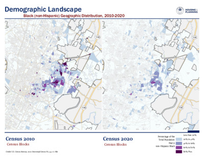
Credit: U.S. Census Bureau, 2020 Decennial Census P.L. 94-171 FileLAKEAUSTIN35118313036035351183183290WALTERE.LONGLAKE130AUSTINBERGSTROMINTERNATIONALAIRPORTWINDSORPARKDAWSONWESTUNIVERSITYMLKSOUTHRIVERCITYMLK-183OLDWESTAUSTINBOULDINCREEKWALNUTCREEK--PIONEERHILLSOUTHEASTUNIVERSITYHILLSWINDSORROADJESTERGALINDOHYDEPARKMCKINNEYWESTOVERHILLSGRACYWOODSPLEASANTVALLEYSOUTHLAMARPECANSPRINGS-SPRINGDALEST.EDWARDSUTHIGHLANDDOWNTOWNHANCOCKTECHRIDGESAMSUNG--PIONEERCROSSINGWESTAUSTINNGBLUFFSPRINGSMONTOPOLISBARTONHILLSGATEWAYWOOTENHOLLYGARRISONPARKGEORGIANACRESEASTCESARCHAVEZNORTHLOOPMCNEILRMMAZILKERLBJWESTCONGRESSDELVALLEBULLCREEKHERITAGEHILLSOLDENFIELDCHESTNUTROSEDALENORTHBURNETBERGSTROMDECKERLAKEGOVALLENORTHSHOALCREEKRIVERSIDEUPPERBOGGYCREEKCORONADOHILLSNORTHLAMARRUNDBERGHIGHLANDPARKROSEWOODPARKERLANEALLANDALEEASTCONGRESSCRESTVIEWCENTRALEASTAUSTINHARRISBRANCHBARTONCREEKMALLTRIANGLESTATENORTHUNIVERSITYST.JOHNSJOHNSTONTERRACENORTHWESTHILLSJOLLYVILLESOUTHMANCHACABRENTWOODFRANKLINPARKNORTHLAMARSWEETBRIARSPICEWOODWINDSORHILLSROGERSHILLLAKEAUSTIN35118313036035351183183290WALTERE.LONGLAKE130AUSTINBERGSTROMINTERNATIONALAIRPORTWINDSORPARKDAWSONWESTUNIVERSITYMLKSOUTHRIVERCITYMLK-183OLDWESTAUSTINBOULDINCREEKWALNUTCREEK--PIONEERHILLSOUTHEASTUNIVERSITYHILLSWINDSORROADJESTERGALINDOHYDEPARKMCKINNEYWESTOVERHILLSGRACYWOODSPLEASANTVALLEYSOUTHLAMARPECANSPRINGS-SPRINGDALEST.EDWARDSUTHIGHLANDDOWNTOWNHANCOCKTECHRIDGESAMSUNG--PIONEERCROSSINGWESTAUSTINNGBLUFFSPRINGSMONTOPOLISBARTONHILLSGATEWAYWOOTENHOLLYGARRISONPARKGEORGIANACRESEASTCESARCHAVEZNORTHLOOPMCNEILRMMAZILKERLBJWESTCONGRESSDELVALLEBULLCREEKHERITAGEHILLSOLDENFIELDCHESTNUTROSEDALENORTHBURNETBERGSTROMDECKERLAKEGOVALLENORTHSHOALCREEKRIVERSIDEUPPERBOGGYCREEKCORONADOHILLSNORTHLAMARRUNDBERGHIGHLANDPARKROSEWOODPARKERLANEALLANDALEEASTCONGRESSCRESTVIEWCENTRALEASTAUSTINHARRISBRANCHBARTONCREEKMALLTRIANGLESTATENORTHUNIVERSITYST.JOHNSJOHNSTONTERRACENORTHWESTHILLSJOLLYVILLESOUTHMANCHACABRENTWOODFRANKLINPARKNORTHLAMARSWEETBRIARSPICEWOODWINDSORHILLSROGERSHILLDemographic LandscapeBlack (non-Hispanic) Geographic Distribution, 2010-2020Census 2010Census 2020Census BlocksCensus BlocksLess than 20%20% to 40%40% to 60%60% to 80%80% PlusPercentage of theTotal Populationthat isnon-Hispanic Black
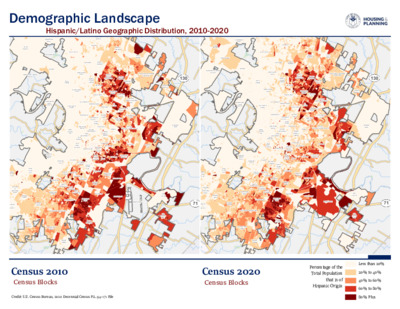
Credit: U.S. Census Bureau, 2020 Decennial Census P.L. 94-171 File3601TRAVIS45360351183MANOR13035118318318329013071ANDERSONMILLWINDSORPARKDAWSONWESTUNIVERSITYMLKSOUTHRIVERCITYMLK-183OLDWESTAUSTINBOULDINCREEKWALNUTCREEK--PIONEERHILLSOUTHEASTUNIVERSITYHILLSWINDSORROADJESTERCIRCLECSOUTHWESTGATEGALINDOBRODIELANEHYDEPARKMCKINNEYWESTOVERHILLSGRACYWOODSPLEASANTVALLEYSOUTHLAMARPECANSPRINGS-SPRINGDALEFOURPOINTSST.EDWARDSUTHIGHLANDDOWNTOWNHANCOCKDITTMAR--SLAUGHTERTECHRIDGESAMSUNG--PIONEERCROSSINGWESTAUSTINNGBLUFFSPRINGSMONTOPOLISCHERRYCREEKBARTONHILLSGATEWAYWOOTENHOLLYGARRISONPARKMANSFIELD--RIVERPLACEGEORGIANACRESEASTCESARCHAVEZNORTHLOOPMCNEILRMMADAVENPORTLAKEAUSTINZILKERLBJWESTCONGRESSVILLAGEATWESTERNOAKSDELVALLEROBINSONRANCHBULLCREEKHERITAGEHILLSOLDENFIELDCHESTNUTROSEDALEDELVALLEEASTNORTHBURNETBERGSTROMSOUTHBRODIEDECKERLAKEGOVALLENORTHSHOALCREEKRIVERSIDEUPPERBOGGYCREEKWESTOAKHILLCORONADOHILLSWHISPERVALLEYONIONCREEKNORTHLAMARRUNDBERGHIGHLANDPARKROSEWOODPARKERLANEALLANDALEEASTCONGRESSCRESTVIEWCENTRALEASTAUSTINHARRISBRANCHBARTONCREEKMALLTRIANGLESTATENORTHUNIVERSITYST.JOHNSJOHNSTONTERRACENORTHWESTHILLSJOLLYVILLESLAUGHTERCREEKSOUTHMANCHACABRENTWOODFRANKLINPARKNORTHLAMARSWEETBRIARSPICEWOODWINDSORHILLSROGERSHILLEASTOAKHILL3601TRAVIS45360351183MANOR13035118318318329013071ANDERSONMILLWINDSORPARKDAWSONWESTUNIVERSITYMLKSOUTHRIVERCITYMLK-183OLDWESTAUSTINBOULDINCREEKWALNUTCREEK--PIONEERHILLSOUTHEASTUNIVERSITYHILLSWINDSORROADJESTERCIRCLECSOUTHWESTGATEGALINDOBRODIELANEHYDEPARKMCKINNEYWESTOVERHILLSGRACYWOODSPLEASANTVALLEYSOUTHLAMARPECANSPRINGS-SPRINGDALEFOURPOINTSST.EDWARDSUTHIGHLANDDOWNTOWNHANCOCKDITTMAR--SLAUGHTERTECHRIDGESAMSUNG--PIONEERCROSSINGWESTAUSTINNGBLUFFSPRINGSMONTOPOLISCHERRYCREEKBARTONHILLSGATEWAYWOOTENHOLLYGARRISONPARKMANSFIELD--RIVERPLACEGEORGIANACRESEASTCESARCHAVEZNORTHLOOPMCNEILRMMADAVENPORTLAKEAUSTINZILKERLBJWESTCONGRESSVILLAGEATWESTERNOAKSDELVALLEBULLCREEKHERITAGEHILLSOLDENFIELDCHESTNUTROSEDALEDELVALLEEASTNORTHBURNETBERGSTROMSOUTHBRODIEDECKERLAKEGOVALLENORTHSHOALCREEKRIVERSIDEUPPERBOGGYCREEKWESTOAKHILLCORONADOHILLSONIONCREEKNORTHLAMARRUNDBERGHIGHLANDPARKROSEWOODPARKERLANEALLANDALEEASTCONGRESSCRESTVIEWCENTRALEASTAUSTINHARRISBRANCHBARTONCREEKMALLTRIANGLESTATENORTHUNIVERSITYST.JOHNSJOHNSTONTERRACENORTHWESTHILLSJOLLYVILLESLAUGHTERCREEKSOUTHMANCHACABRENTWOODFRANKLINPARKNORTHLAMARSWEETBRIARSPICEWOODWINDSORHILLSROGERSHILLEASTOAKHILLDemographic LandscapeHispanic/Latino Geographic Distribution, 2010-2020Census 2010Census 2020Census BlocksCensus BlocksLess than 20%20% to 40%40% to 60%60% to 80%80% PlusPercentage of theTotal Populationthat is ofHispanic Origin
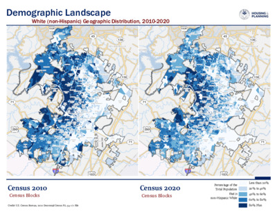
Credit: U.S. Census Bureau, 2020 Decennial Census P.L. 94-171 File183LAKEWAYJONESTOWN183A360351290TRAVIS4536071351183MANORPFLUGERVILLE1301304535118318318329013071ANDERSONMILLWINDSORPARKDAWSONWESTUNIVERSITYMLKSOUTHRIVERCITYMLK-183OLDWESTAUSTINBOULDINCREEKWALNUTCREEK--PIONEERHILLSOUTHEASTUNIVERSITYHILLSWINDSORROADJESTERCIRCLECSOUTHWESTGATEGALINDOBRODIELANEHYDEPARKMCKINNEYWESTOVERHILLSGRACYWOODSPLEASANTVALLEYSOUTHLAMARPECANSPRINGS-SPRINGDALEFOURPOINTSPONDSPRINGSST.EDWARDSUTHIGHLANDDOWNTOWNHANCOCKDITTMAR--SLAUGHTERTECHRIDGESAMSUNG--PIONEERCROSSINGWESTAUSTINNGBLUFFSPRINGSMONTOPOLISCHERRYCREEKBARTONHILLSGATEWAYWOOTENHOLLYGARRISONPARKMANSFIELD--RIVERPLACEGEORGIANACRESEASTCESARCHAVEZNORTHLOOPMCNEILRMMADAVENPORTLAKEAUSTINZILKERHAYSWARTHALBJWESTCONGRESSVILLAGEATWESTERNOAKSDELVALLEROBINSONRANCHBULLCREEKHERITAGEHILLSOLDENFIELDCHESTNUTROSEDALEDELVALLEEASTNORTHBURNETBERGSTROMSOUTHBRODIEDECKERLAKEGOVALLENORTHSHOALCREEKRIVERSIDEUPPERBOGGYCREEKWESTOAKHILLCORONADOHILLSONIONCREEKNORTHLAMARRUNDBERGHIGHLANDPARKROSEWOODPARKERLANEALLANDALEEASTCONGRESSCRESTVIEWAVERYRANCH--LAKELINECENTRALEASTAUSTINHARRISBRANCHBARTONCREEKMALLTRIANGLESTATENORTHUNIVERSITYST.JOHNSJOHNSTONTERRACENORTHWESTHILLSJOLLYVILLESLAUGHTERCREEKSOUTHMANCHACABRENTWOODFRANKLINPARKNORTHLAMARSWEETBRIARSPICEWOODWINDSORHILLSROGERSHILLEASTOAKHILL183LAKEWAYJONESTOWN183A360351290TRAVIS4536071351183MANORPFLUGERVILLE1301304535118318318329013071ANDERSONMILLWINDSORPARKDAWSONWESTUNIVERSITYMLKSOUTHRIVERCITYMLK-183OLDWESTAUSTINBOULDINCREEKWALNUTCREEK--PIONEERHILLSOUTHEASTUNIVERSITYHILLSWINDSORROADJESTERCIRCLECSOUTHWESTGATEGALINDOBRODIELANEHYDEPARKMCKINNEYWESTOVERHILLSGRACYWOODSPLEASANTVALLEYSOUTHLAMARPECANSPRINGS-SPRINGDALEFOURPOINTSPONDSPRINGSST.EDWARDSUTHIGHLANDDOWNTOWNHANCOCKDITTMAR--SLAUGHTERTECHRIDGESAMSUNG--PIONEERCROSSINGWESTAUSTINNGBLUFFSPRINGSMONTOPOLISCHERRYCREEKBARTONHILLSGATEWAYWOOTENHOLLYGARRISONPARKMANSFIELD--RIVERPLACEGEORGIANACRESEASTCESARCHAVEZNORTHLOOPMCNEILRMMADAVENPORTLAKEAUSTINZILKERHAYSWARTHALBJWESTCONGRESSVILLAGEATWESTERNOAKSDELVALLEROBINSONRANCHBULLCREEKHERITAGEHILLSOLDENFIELDCHESTNUTROSEDALEDELVALLEEASTNORTHBURNETBERGSTROMSOUTHBRODIEDECKERLAKEGOVALLENORTHSHOALCREEKRIVERSIDEUPPERBOGGYCREEKWESTOAKHILLCORONADOHILLSONIONCREEKNORTHLAMARRUNDBERGHIGHLANDPARKROSEWOODPARKERLANEALLANDALEEASTCONGRESSCRESTVIEWAVERYRANCH--LAKELINECENTRALEASTAUSTINHARRISBRANCHBARTONCREEKMALLTRIANGLESTATENORTHUNIVERSITYST.JOHNSJOHNSTONTERRACENORTHWESTHILLSJOLLYVILLESLAUGHTERCREEKSOUTHMANCHACABRENTWOODFRANKLINPARKNORTHLAMARSWEETBRIARSPICEWOODWINDSORHILLSROGERSHILLEASTOAKHILLDemographic LandscapeWhite (non-Hispanic) Geographic Distribution, 2010-2020Census 2010Census 2020Census BlocksCensus BlocksLess than 20%20% to 40%40% to 60%60% to 80%80% PlusPercentage of theTotal Populationthat isnon-Hispanic White
Independent Citizens Redistricting Commission (ICRC) August 18, 2021 at 6:00 p.m. Video Conference Join Zoom Meeting https://zoom.us/j/98278207374?pwd=eEhDSFpzNjVlZWFXNGcyYWpOKzZvZz09 Meeting ID: 982 7820 7374 Passcode: iqY34Q CURRENT COMMISSION MEMBERS: Prabhu Kannan Brigham Morris Errol Hardin Eugene Schneider Erin Dempsey Luis Gonzalez, Vice-Chair Dr. Sterling Lands Hoang Le Shaina Kambo Sara Inés Calderón Selina Yee Christina Puentes, Chair Joshua Blank Camellia Falcon Staff In Attendance Matthew Dugan, City's Planning Manager George Korbel, Mapping Specialist Christine Granados, ICRC Administrative Manager Members in Attendance Christina Puentes, Chair Luis Gonzalez, Vice Chair Joshua Blank Sara Inés Calderón Erin Dempsey Camellia Falcon Errol Hardin Prabhu Kannan Dr. Sterling Lands Hoang Le Eugene Schneider Selina Yee MINUTES Meeting Goals: Receive Information about Census Data and City's Boundaries; Receive Updates from Working Groups/Subcommittees CALL TO ORDER Chair Puentes called the meeting to order at 6:01 p.m. with 11 members present. Commissioner Kannan joined the meeting at 6:05 p.m. CITIZEN COMMUNICATION: GENERAL The first three speakers who register to speak no later than noon the day before the meeting will be allowed a three-minute allotment to address their concerns regarding items not posted on the agenda. Peck Young addressed the ICRC and opted to withhold comment at the public meeting. 1. APPROVAL OF MINUTES Discussion and possible action on the Aug. 11, 2021, ICRC meeting minutes. The Aug. 11, 2021, meeting minutes were approved without objection. 2. UNFINISHED BUSINESS The ICRC may discuss and take action on the following agenda items A. Update from Public Forum Working Group on calendar changes Vice Chair Gonzalez gave update about county public forums being pushed back a week. 3. NEW BUSINESS The ICRC may discuss and take action on the following agenda items A. Presentation from Lila Valencia, Austin City Demographer City Demographer Lila Valencia shared findings from 2020 U.S. Census. B. Presentation from City Attorney on open meetings Assistant City Attorney Lynn Carter reviewed Open Meetings Act; Assistant City Attorney Zach Brown reviewed the Public Information Act. C. Update from Communications Working Group Commissioner Calderón discussed social media policies and the work done placing paid advertising on social media and legacy media. D. Update from Finance Subcommittee Vice Chair Gonzalez discussed the $2,000 in expenditures for Zoom moderator, website maintenance and overtime charges related to public forums. E. Update from Final Report Subcommittee No update. F. Discussion on mapping process Commissioner Yee made a motion to allow commissioners to voluntarily meet one-on-one …
Rodriguez, Lisa From: Sent: To: Subject: HPD ICRC Commissioners Wednesday, August 18, 2021 8:01 PM HPD ICRC Commissionsers DL FW: Dist 1 Redistricting Forum From: outlook_22023918880C600B@outlook.com <outlook_22023918880C600B@outlook.com>On Behalf Ofoutlook_22023918880C600B@outlook.com < Sent: Thursday, August 19, 2021 1:00:58 AM (UTC+00:00) Monrovia, Reykjavik To: HPD ICRC Commissioners <ICRC.Commissioners@austintexas.gov> Subject: Dist 1 Redistricting Forum *** External Email - Exercise Caution *** Sent from Mail for Windows I was wondering why this forum meeting was not offered on zoom. Looks like the other districts forum could be attended on zoom. CAUTION: This email was received at the City of Austin, from an EXTERNAL source. Please use caution when clicking links or opening attachments. If you believe this to be a malicious and/or phishing email, please forward this email to cybersecurity@austintexas.gov. 1
Rodriguez, Lisa From: Sent: To: Subject: HPD ICRC Commissioners Friday, August 20, 2021 4:09 PM HPD ICRC Commissionsers DL FW: Inquiry: Rules and procedure for Invited Testimony from Organizations to Independent Redistricting Commission From: Vice President - NWACA < Sent: Friday, August 20, 2021 9:08:12 PM (UTC+00:00) Monrovia, Reykjavik To: HPD ICRC Commissioners <ICRC.Commissioners@austintexas.gov>; Rodriguez, Lisa <Lisa.Rodriguez@austintexas.gov>; Dugan, Matthew <Matthew.Dugan@austintexas.gov> Cc: Subject: Inquiry: Rules and procedure for Invited Testimony from Organizations to Independent Redistricting Commission < < *** External Email - Exercise Caution *** To the Commission, I see on your posted agenda for August 28th - located here http://www.austintexas.gov/edims/document.cfm?id=366131 - that a private organization has been invited to give testimony under 3. New Business, Item C. m m m m V I have checked all the emails to our organization and do not recall seeing an invitation for similar invited testimony, or rules being previously communicated. Please let me know if this is an oversight on my part. What are the rules and processes for other private organizations to be allowed to give invited testimony? If all organizations in the City, and relevant State/Federal level advocacy groups, are not allowed to provide invited testimony, under what rules is it fair for a single private organization to provide that testimony? 1 Please let us know what actions we can take so that our organization - and our members - can participate on an equal basis with other private organizations. CAUTION: This email was received at the City of Austin, from an EXTERNAL source. Please use caution when clicking links or opening attachments. If you believe this to be a malicious and/or phishing email, please forward this email to cybersecurity@austintexas.gov. 2
From: Sent: To: Subject: Attachments: HPD ICRC Commissioners Thursday, August 19, 2021 7:39 AM HPD ICRC Commissionsers DL FW: ICRC citizen input on: (1) Commissioner Yee's request for socio-economic City of Austin data PXL_20210819_114536587.jpg Rodriguez, Lisa From: Philip Wiley < Sent: Thursday, August 19, 2021 12:38:48 PM (UTC+00:00) Monrovia, Reykjavik To: HPD ICRC Commissioners <ICRC.Commissioners@austintexas.gov> Subject: ICRC citizen input on: (1) Commissioner Yee's request for socio-economic City of Austin data *** External Email - Exercise Caution *** Commissioners, Commissioner Yee inquired in yesterday's ICRC meeting about socio‐economic data for the City of Austin. I let data astute people interested in policy know. This is what came back, lots of really good stuff here. Prepared by consultants for the City of Austin, the 2020 report is entitled "City of Austin Comprehensive Housing Report", but it's much more. https://austintexas.gov/sites/default/files/files/Housing/Austin%20HMA final.pdf I've taken a photo of one chart below, which to me was a pretty good proxy for generalized socio economic grouping from 2013 when your predecessors created a map. Next to that is how the City has evolved since. My reading of the charter is that this map is a solid place to center identification of communities of interest ‐ but the last ICRC chose another approach ‐ it's your turn, and our best hope is that every map iteration improves on the hard work of those who came before. 4) the geographic integrity of any local neighborhood or local community of interest shall be respected in a manner that minimizes their division to the extent possible without violating the requirements of any of the preceding subsections. A community of interest is a contiguous population that shares common social and economic interests that should be included within a single district for purposes of its effective and fair representation. Communities of interest shall not include relationships with political parties, incumbents, or political candidates. This wasn't the only response I got, but as it's a public City asset, it seemed like the best first response. Please don't hesitate to ask if more of any type of data might be helpful. Time is short, and it takes a village. Thanks again ‐ your time commitment and effort is extraordinary! Philip Wiley Downtown resident ‐ D9 1 CAUTION: This email was received at the City of Austin, from an EXTERNAL source. Please use caution when clicking links or opening attachments. If you believe this to be …
Versión en español a continuación. Finance/Allocations Committee Meeting of the HIV Planning Council WEDNESDAY, AUGUST 18, 2021 Finance/Allocations Committee Meeting to be held on August 18, 2021, with Social Distancing Modifications Public comment will be allowed via telephone; no in-person input will be allowed. All speakers must register in advance (08/17/2021 by noon). All public comment will occur at the beginning of the meeting. To speak remotely at the August 18, 2021, HIV Planning Council Meeting, members of the public must: •Call or email the board liaison at (512) 972-5806 and Jaseudia.Killion@austintexas.gov no later than noon, (the day before the meeting). The information required is the speaker name, item number(s) they wish to speak on, whether they are for/against/neutral, and a telephone number or email address. •Once a request to speak has been called in or emailed to the board liaison, residents will receive either an email or phone call providing the telephone number to call on the day of the scheduled meeting. •Speakers must call in at least 15 minutes prior to meeting start in order to speak, late callers will not be accepted and will not be able to speak. •Speakers will be placed in a queue until their time to speak. •Handouts or other information may be emailed to Jaseudia.Killion@austintexas.gov by Noon the day before the scheduled meeting. This information will be provided to Board and Commission members in advance of the meeting. •If this meeting is broadcast live, residents may watch the meeting here: http://www.austintexas.gov/page/watch- atxn-live la junta en Reunión del Finance/Allocations Meeting of the HIV Planning Council Wednesday, August 18, 2021 FECHA de la reunion (Augusto 18, 2021) La junta se llevará con modificaciones de distanciamiento social Se permitirán comentarios públicos por teléfono; no se permitirá ninguna entrada en persona. Todos los oradores deben registrarse con anticipación (08/17/2021 antes del mediodía). Todos los comentarios públicos se producirán al comienzo de la reunión. Para hablar de forma remota en la reunión, los miembros del público deben: • Llame o envíe un correo electrónico al enlace de (512) 972-5806 and Jaseudia.Killion@austintexas.gov a más tardar al mediodía (el día antes de la reunión). La información requerida es el nombre del orador, los números de artículo sobre los que desean hablar, si están a favor / en contra / neutrales, y un número de teléfono o dirección de correo electrónico. • Una vez que se haya llamado o enviado …
Versión en español a continuación. Environmental Commission Regular Meeting August 18, 2021 Environmental Commission to be held August 18, 2021 with Social Distancing Modifications. Public comment will be allowed via telephone; no in-person input will be allowed. All speakers must register in advance (August 17, 2021 by noon). All public comment will occur at the beginning of the meeting. To speak remotely at the August 18, 2021 Environmental Commission Regular Meeting, members of the public must: •Call or email the board liaison Kaela Champlin, (512) 974-3443, Kaela.Champlin@austintexas.gov, no later than noon, (the day before the meeting). The following information is required: speaker name, item number(s) they wish to speak on, whether they are for/against/neutral, email address and telephone number (must be the same number that will be used to call into the meeting). •Once a request to speak has been made to the board liaison, the information to call on the day of the scheduled meeting will be provided either by email or phone call. •Speakers must call in at least 15 minutes prior to meeting start time in order to speak, late callers will not be accepted and will not be able to speak. •Speakers will be placed in a queue until their time to speak. •Handouts or other information may be emailed to Kaela.Champlin@austintexas.gov by noon the day before the scheduled meeting. This information will be provided to Board and Commission members in advance of the meeting. •If the meeting is broadcast live, it may be viewed here: http://www.austintexas.gov/page/watch-atxn- live 1 Reunión del Environmental Commission FECHA de la reunion (18 de agosto de 2021) La junta se llevará con modificaciones de distanciamiento social Se permitirán comentarios públicos por teléfono; no se permitirá ninguna entrada en persona. Todos los oradores deben registrarse con anticipación (17 de agosto de 2021 antes del mediodía). Todos los comentarios públicos se producirán al comienzo de la reunión. Para hablar de forma remota en la reunión, los miembros del público deben: • Llame o envíe un correo electrónico al enlace de la junta en Kaela Champlin, (512) 974-3443, Kaela.Champlin@austintexas.gov a más tardar al mediodía (el día antes de la reunión). Se requiere la siguiente información: nombre del orador, número (s) de artículo sobre el que desean hablar, si están a favor / en contra / neutral, dirección de correo electrónico (opcional) y un número de teléfono (debe ser el número que se utilizará para …
Updating the TCEQ TMDL Implementation Plan for • Waller, • Walnut, • Taylor Slough South, and • Spicewood Trib of Shoal Julie White Environmental Program Coordinator Julie.White@austintexas.gov 512-974-3527 Andrew Clamann Environmental Scientist Senior Andrew.Clamann@austintexas.gov 512-974-2694 This is not my beautiful creek! You may ask yourself: How did we get here? Water quality monitoring data submitted to the State If data indicates impairment, then the stream is placed on the "303(d)* list" * Clean Water Act Section 303(d) requires states to regularly identify water bodies that do not meet water quality standards ** TMDL (Total Maximum Daily Load): a program to analyze data with goal to resolve issue State develops a TMDL** with an Implementation Plan aka "IPlan" You may ask yourself: My God, what's an IPLAN? • A set of strategies to achieve the goal of pollution reduction outlined in the TMDL • Facilitated by TCEQ staff • Developed by stakeholders • 5year implementation period (+ revisions) An I-plan outlines: • What the community will do over the next five years • Who will do it • When they will do it • How we will gauge improvement Currently there are 5 Austin watersheds with IPlans (due to bacteria impairment) IPlan approved in 2011, revised 2017 Gilleland Waller Walnut Taylor Slough South Spicewood Trib of Shoal IPlan for 4 urban watersheds approved in 2015, expired* in 2020, now require revision *IPlans have 5-year approval periods after which they are reviewed and revised (if necessary) The 2015-2020 IPlan for 4 Austin urban creeks 5 primary voluntary strategies • Protect and restore riparian areas • Maintain wastewater infrastructure – includes OSSF, adding public toilets • Improve domestic pet waste management • Education/ public outreach to engage citizens • Improve management of stormwater MS4 Permit & Stormwater Management Program (SWMP) • Population triggered regulatory permit designed to reduce pollutant discharges into city stormwater conveyances. • Develop and implement a plan and submit accomplishments to the TCEQ annually • Periodic audits by TCEQ or EPA Measures to reduce stormwater pollution aka Minimum Control Measures (MCMs) 1. MS4 Maintenance Activities 2. Post-Construction Storm Water Control Measures 3. Illicit Discharge Detection and Elimination 4. Pollution Prevention/Good Housekeeping for Municipal Operations 5. Industrial and High Risk Runoff 6. Construction Site Storm Water Runoff 7. Public Education and Involvement 8. Monitoring Programs I thought we were talking about I-plans? TMDL measures (previously voluntary) are now required to be …
Youth Education Elementary, Middle and High School COVID Pandemic School Year 2020-2021 Education Programs Covid-19 Response Teachers pivoted to a VIRTUAL FORMAT: teaching to a camera, interacting with students as a host via Zoom and performing the role of videographer. Equipment identified and acquired to teach virtually in the field. Two more Teaching Videos produced to add to the ten videos produces in April/May 2020. All videos uploaded to the City of Austin YouTube Channel. Lessons were recreated and rewritten for a VIRTUAL LIVE presentation. Kahoot games created for lessons. Fun timers and Wheel of Names for prizes to promote student participation. Hands-on materials for LIVE interactions delivered to schools. . Fifth grade Virtual Earth Camp 1047 students from 19 schools • • LIVE Zoomed from the Field Interactive Lessons Students made paper watersheds Student Ethnicity Mapped their school’s watershed Used a hairnet to simulate a helmet to enter a cave of the aquifer virtually Mixed Ethnicity/Other 2% White 7% Asian/Pacific Islander 3% Black 9% Hispanic 79% Planted seeds. Fifth grade Virtual Earth School 1463 students from 16 schools Student Ethnicity Hispanic 32% White 52% Mixed Ethnicity/Other 5% Black 3% Asian/Pacific Islander 8% Put photos here LIVE classroom Zoom Interactive Lesson • Paper Watershed Model Activity • Aquifer & Watershed Model Demonstrations • Breakout Room Discussions about Pollution & Solutions • Flood Safety Awareness Presentation Elementary & Middle school Virtual Clean Creek Campus 1,376 students from 14 schools LIVE, in the field and classroom, Zoom Interactive Lessons for CLEAN CREEK CAMPUS Langford 5th grade teacher: “Being able to go on a virtual field trip this year was a real treat for the students. Honestly, it increased participation in zoom classes. The virtual field trip was the highlight for sure! The educators did a really good job answering students' questions on the spot and allowing for a lot of class participation to maintain engagement throughout. It was fantastic!” Middle School Watershed Detectives cancelled due to COVID Partnered with CaveSim to deliver virtual programming to 1008 students 3 middle schools and 3 elementary schools Student Ethnicity Mixed Ethnicity/Other 1% Asian/Pacific Islander 4% Black 6% White 15% Hispanic 74% High School Hydrofiles cancelled due to COVID Participated in Barton Springs University Virtual Presentation – 29 students Partnered with PARD Ranger Cadet Program High school Austin Youth River Watch 49 students Pandemic Adjusted Goals: Virtual Program Delivery Materials Delivered Small Group Virtual …
The Austin Parks and Recreation Department and The Trail Foundation Partnership Agreement Environmental Commision Parks and Recreation Department, City of Austin Christine Chute Canul, PARD Partnership Manager Heidi Anderson, CEO, The Trail Foundation Al Godfrey, Board Member, The Trail Foundation August 18, 2021 The Trail Foundation 2 The Trail Foundation (TTF) A 501(c)3 dedicated to protecting, enhancing, and connecting the Butler Hike-and-Bike Trail at Lady Bird Lake for the benefit of all. TTF/City of Austin Partnership Timeline 1971 – Public-private civic effort formed led by the Citizen’s Committee for a More Beautiful Town Lake 2003 – Town Lake Trail Foundation (now The Trail Foundation) was formed to continue the work of the Citizen’s Committee and ensure that the Trail remains one of Austin’s outstanding places 2014 – Boardwalk opens, completes the 10+ mile loop of the Ann and Roy Butler Trail 2015 – TTF adopted the Butler Trail at Lady Bird Lake Urban Forestry and Natural Areas Management Guidelines, developed by Siglo Group in consultation with TTF, Austin Parks and Recreation (PARD) and the City of Austin Watershed Protection Department (WPD). 2018 – PARD and TTF begin discussions to formalize partnership 2020 – Formal process begins to enter into phased Parkland Operations & Maintenance Agreement (POMA) with PARD 3 TTF Investment & Public Benefit Since 2003, TTF has invested more than $17,550,000 on the Butler Trail and the Town Lake Metro Park, including infrastructure projects, ecological restoration, and maintenance. Pre-pandemic (2019) Annual TTF Investment: $3,319,731 Volunteer Impact Since January 2017: 219 Volunteer Events 3,988 Volunteers 15,687 Sapling Trees Planted 1,588 Yards of Mulch/compost Spread 59.4 Acres of Wildflowers Planted ...In addition to an increasingly robust volunteer impact program. Just this year, 400+ bags of trash were collected and 71 screech owl nest boxes were made and installed. 4 Council Resolution - 20200312-041 BE IT RESOLVED BY THE CITY COUNCIL OF THE CITY OF AUSTIN: The City Council expresses support for the concept of parkland agreements between nonprofit organizations and PARD if the agreements further the mission And vision of the department with regard to non- enterprise fund public parks and trails in an effective, efficient, and inclusive manner. BE IT RESOLVED: The City Council directs the City Manager to work with parks nonprofit partners that have established relationships with PARD, including but not limited to The Trail Foundation and …
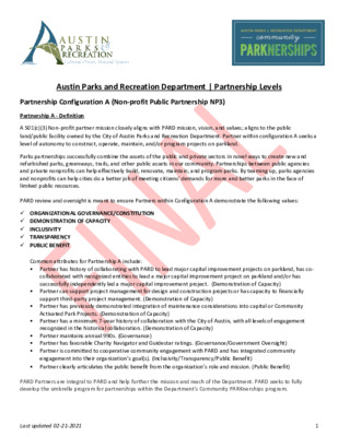
Austin Parks and Recreation Department | Partnership Levels Partnership Configuration A (Non-profit Public Partnership NP3) Partnership A - Definition A 501(c)(3) Non-profit partner mission closely aligns with PARD mission, vision, and values; aligns to the public land/public facility owned by the City of Austin Parks and Recreation Department. Partner within configuration A seeks a level of autonomy to construct, operate, maintain, and/or program projects on parkland. Parks partnerships successfully combine the assets of the public and private sectors in novel ways to create new and refurbished parks, greenways, trails, and other public assets in our community. Partnerships between public agencies and private nonprofits can help effectively build, renovate, maintain, and program parks. By teaming up, parks agencies and nonprofits can help cities do a better job of meeting citizens' demands for more and better parks in the face of limited public resources. PARD review and oversight is meant to ensure Partners within Configuration A demonstrate the following values: ✓ ORGANIZATIONAL GOVERNANCE/CONSTITUTION ✓ DEMONSTRATION OF CAPACITY ✓ INCLUSIVITY ✓ TRANSPARENCY ✓ PUBLIC BENEFIT Common attributes for Partnership A include: • Partner has history of collaborating with PARD to lead major capital improvement projects on parkland, has co- collaborated with recognized entities to lead a major capital improvement project on parkland and/or has successfully independently led a major capital improvement project. (Demonstration of Capacity) • Partner can support project management for design and construction projects or has capacity to financially support third-party project management. (Demonstration of Capacity) • Partner has previously demonstrated integration of maintenance considerations into capital or Community Activated Park Projects. (Demonstration of Capacity) • Partner has a minimum 7-year history of collaboration with the City of Austin, with all levels of engagement recognized in the historical collaboration. (Demonstration of Capacity) • Partner maintains annual 990s. (Governance) • Partner has favorable Charity Navigator and Guidestar ratings. (Governance/Government Oversight) • Partner is committed to cooperative community engagement with PARD and has integrated community engagement into their organization’s goal(s). (Inclusivity/Transparency/Public Benefit) • Partner clearly articulates the public benefit from the organization’s role and mission. (Public Benefit) PARD Partners are integral to PARD and help further the mission and reach of the Department. PARD seeks to fully develop the umbrella program for partnerships within the Department’s Community PARKnerships program. Last updated 02-21-2021 1 Partnership A - Criteria This level of partnership requires a formal partnership review process. The review process will take up …
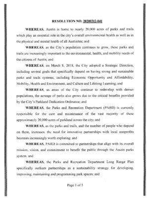
RESOLUTION NO. 20200312-041 WHEREAS, Austin is home to nearly 20,000 acres of parks and trails which play an essential role in the city's overall environmental health as well as in the physical and mental health of all Austinites; and WHEREAS, as the City's population continues to grow, these parks and trails are increasingly important to the environmental, health, and mobility needs of the citizens of Austin; and WHEREAS, on March 8, 2018, the City adopted a Strategic Direction, including several goals that specifically depend on having strong and sustainable including Economic Opportunity and Affordability, parks and trails systems, Mobility, Health and Environment, and Culture and Lifelong Learning; and WHEREAS, as areas of the City continue to redevelop with denser populations, the acreage of parks also grows due to the critical benefits provided by the City' s Parkland Dedication Ordinance; and WHEREAS, the Parks and Recreation Department (PARD) is currently these the vast majority of responsible for approximately 20,000 acres of parkland across the city; and the care and maintenance of WHEREAS, as the parks and trails, and the number of people who depend the need for innovative partnerships with local nonprofits increases, on them, becomes increasingly worth exploring; and WHEREAS, PARD is committed to partnerships that align with its overall mission, vision, and commitment to benefit the public through the Austin parks system; and WHEREAS, the Parks and Recreation Department Long Range Plan specifically outlines partnerships as a sustainability strategy for developing, improving, maintaining and programming park spaces; and Page 1 of 3 WHEREAS, PARD works with nonprofit organizations, conservancies, increase community groups, and businesses to enhance and improve parks, recreational and cultural opportunities, and preserve natural areas in Austin; and WHEREAS, the goals of these partnerships are to enhance and expand public use of PARD's grounds and facilities; encourage active recreation and healthy lifestyles; improve environmental stewardship through public participation and education; celebrate arts, culture, and history to build community; and maximize public benefit at minimum taxpayer cost; and WHEREAS, many peer cities such as Dallas, Houston, Chicago, New York City, and others have negotiated partnerships with nonprofit organizations dedicated to the maintenance and stewardship of particular parks; and WHEREAS, nonprofit organizations dedicated to improving parks and open space for the benefit of the community often have the ability to fundraise and other opportunities that municipalities do not have; and WHEREAS, in Austin, some nonprofits have already begun partnering …
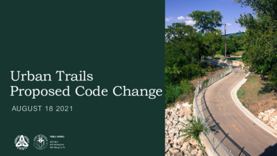
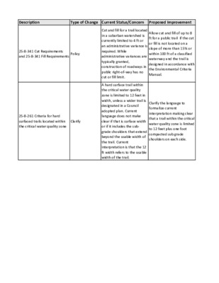
Urban Trails Proposed Code Change AUGUST 18 2021 Agenda 8.18.2021 I. Background #EFA160 #16362F II. Proposed Code Changes LDC 25-8-341/342 I. II. LDC 25-1-261(B)(3)(c) #1886CA III. Q&A PUBLIC WORKS DEPARTMENT – CITY OF AUSTIN 2 Background Resolution NO. 20200220-045 ] PUBLIC WORKS DEPARTMENT – CITY OF AUSTIN 3 Background February 2020 April 2020 • Resolution NO. 20200220-045 Passed • Stakeholder Group Convened January 2021 #EFA160 • Memo response to Resolution June 2021 #16362F • Resolution NO. 20210610-041 Passed Resolution NO. 20210610-041 #1886CA “(2) Council initiates the following amendments to the Land Development Code, as recommended by PWD and WPD in Appendix B of the January 4, 2021 memo from PWD, and asks that they be brought back to Council by August 26, 2021: (a) Amend Land Development Code 25-8-341 and 25-8-342 to grant urban trails projects greater cut and fill allowances under specific environmental circumstances. (b) Amend Land Development Code 25-8-261(B)(3)(c) to reflect current policy that trails within the critical water quality zone be limited to 12 feet in surface width plus one-foot shoulders on each side. PUBLIC WORKS DEPARTMENT – CITY OF AUSTIN 4 PURPOSE • Streamline review process • Create transparency • Formalize internal policy LDC 25-8-341 & 25-8-342: Cut and Fill Current Status: Cut and/or fill in a suburban watershed is limited to 4 ft in depth Administrative variance typically granted to allow up to 8 ft, with certain conditions Construction of roadways in public right-of-way has no cut or fill limit Proposed Improvement #EFA160 #16362F Allow cut and/or fill of up to 8 ft for a public trail if: The cut or fill is not located on a slope of more than 15% The cut or fill is not located within 100 #1886CA ft of a classified waterway; and The trail is constructed in accordance with the Environmental Criteria Manual. PUBLIC WORKS DEPARTMENT – CITY OF AUSTIN 6 NORTHERN WALNUT CREEK TRAIL Northern Walnut Creek Trail Phase 2A • Construction beginning November 2021 • Granted admin variance from cut and fill requirements LDC 25-8-261: Critical Water Quality Zone Development Current Status: A hard surface trail within the critical water quality zone is limited to 12 feet in width, unless a wider trail is designated in a Council adopted plan. Current language does not make clear if the 12 ft refers to the surface width or if it includes …
Description Type of Change Current Status/Concern Proposed Improvement 25-8-341 Cut Requirements and 25-8-341 Fill Requirements Policy 25-8-261 Criteria for hard surfaced trails located within the critical water quality zone Clarify Cut and fill for a trail located in a suburban watershed is currently limited to 4 ft or an administrative variance is required. While administrative variances are typically granted, construction of roadways in public right-of-way has no cut or fill limit. A hard surface trail within the critical water quality zone is limited to 12 feet in width, unless a wider trail is designated in a Council adopted plan. Current language does not make clear if that is surface width or if it includes the sub- grade shoulders that extend beyond the usable width of the trail. Current interpretation is that the 12 ft width refers to the usable width of the trail. Allow cut and fill of up to 8 ft for a public trail if the cut or fill is not located on a slope of more than 15% or within 100 ft of a classified waterway and the trail is designed in accordance with the Environmental Criteria Manual. Clarify the language to formalize current interpretation making clear that a trail within the critical water quality zone is limited to 12 feet plus one foot compacted sub grade shoulders on each side. Advantage Disadvantage Streamlines review process. None Formalizes internal policy. None
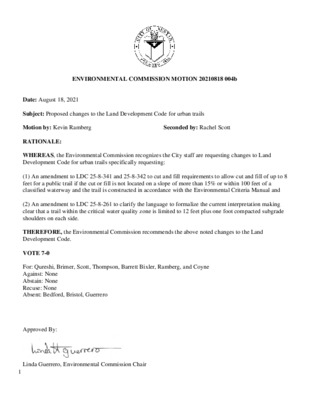
1 ENVIRONMENTAL COMMISSION MOTION 20210818 004b Date: August 18, 2021 Seconded by: Rachel Scott Subject: Proposed changes to the Land Development Code for urban trails Motion by: Kevin Ramberg RATIONALE: WHEREAS, the Environmental Commission recognizes the City staff are requesting changes to Land Development Code for urban trails specifically requesting: (1) An amendment to LDC 25-8-341 and 25-8-342 to cut and fill requirements to allow cut and fill of up to 8 feet for a public trail if the cut or fill is not located on a slope of more than 15% or within 100 feet of a classified waterway and the trail is constructed in accordance with the Environmental Criteria Manual and (2) An amendment to LDC 25-8-261 to clarify the language to formalize the current interpretation making clear that a trail within the critical water quality zone is limited to 12 feet plus one foot compacted subgrade shoulders on each side. THEREFORE, the Environmental Commission recommends the above noted changes to the Land Development Code. VOTE 7-0 For: Qureshi, Brimer, Scott, Thompson, Barrett Bixler, Ramberg, and Coyne Against: None Abstain: None Recuse: None Absent: Bedford, Bristol, Guerrero Approved By: Linda Guerrero, Environmental Commission Chair
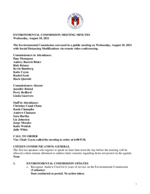
ENVIRONMENTAL COMMISSION MEETING MINUTES Wednesday, August 18, 2021 The Environmental Commission convened in a public meeting on Wednesday, August 18, 2021 with Social Distancing Modifications via remote video conferencing. Commissioners in Attendance: Pam Thompson Audrey Barrett Bixler Rick Brimer Kevin Ramberg Katie Coyne Rachel Scott Haris Qureshi Commissioners Absent: Jennifer Bristol Perry Bedford Linda Guerrero Staff in Attendance: Christine Canal Chute Kaela Champlin Andrew Clamann Sara Hartley Liz Johnston Jorge Morales Katie Wettick Julie White CALL TO ORDER Vice Chair Coyne called the meeting to order at 6:00 P.M. CITIZEN COMMUNICATION: GENERAL The first ten speakers who register to speak no later than noon the day before the meeting will be allowed a three-minute allotment to address their concerns regarding items not posted on the agenda. None 1. ENVIRONMENTAL COMMISSION UPDATES a. Recognize Andrew Creel for 6 years of service on the Environmental Commission (5 minutes) Item conducted as posted. No action taken. 1 2. 3. 4. b. New Environmental Commission member welcome and introduction (5 minutes) Item conducted as posted. No action taken. APPROVAL OF MINUTES AND ACTION a. Approval of the August 4, 2021 Environmental Commission Meeting Minutes (5 minutes) A motion to approve the August 4, 2021 Environmental Commission Meeting Minutes was approved on Commissioner Ramberg’s motion, Commissioner Brimer’s second on a 6-0 vote. Commissioner Scott were off the dais. Commissioners Bristol, Bedford, and Guerrero were absent. BRIEFINGS a. Update on School Year 2020-2021 WPD Youth Education Report—Susan Wall, Conservation Program Coordinator, Watershed Protection Department (15 minutes) Item conducted as posted. No action taken. b. Updating the Texas Commission on Environmental Quality (TCEQ) Total Maximum Daily Load (TMDL) Implementation Plan for Waller, Walnut, Taylor Slough South, and the Spicewood Tributary of Shoal Creek—Julie White, Environmental Program Coordinator and Andrew Clamann, Environmental Scientist Senior, Watershed Protection Department (30 minutes) Item conducted as posted. No action taken. ITEMS FOR CONSIDERATION AND POSSIBLE ACTION a. Joint presentation on the Programing, Operations and Maintenance Agreement between the Parks and Recreation Department (PARD) and The Trail Foundation (TTF)— Christine Canal Chute, Program Manager II, PARD, Heidi Anderson, CEO, TTF and Al Godfrey, TTF Board Member (30 minutes) Commissioner Coyne recused on Item 4a. Item conducted as posted. No action taken. b. Discuss and consider proposed changes to the Land Development Code for Urban Trails including: 1. Amendment to LDC 25-8-341 and 25-8-342 to cut and fill requirements to allow cut and fill …
Electrical Board August 18, 2021 @10:00 AM Electrical Board to be held August 18, 2021 at 10:00 am with Social Distancing Modifications Public comment will be allowed via telephone; no in-person input will be allowed. All speakers must register in advance (Tuesday August 17, 2021 by noon). All public comment will occur at the beginning of the meeting. To speak remotely at the August 18, Electrical Board Meeting, residents must: •Call or email the board liaison at Rick Arzola at 512-974-2417 no later than noon, (the day before the meeting). The information required is the speaker name, item number(s) they wish to speak on, whether they are for/against/neutral, and a telephone number or email address. •Once a request to speak has been called in or emailed to the board liaison, residents will receive either an email or phone call providing the telephone number to call on the day of the scheduled meeting. •Speakers must call in at least 15 minutes prior to meeting start in order to speak, late callers will not be accepted and will not be able to speak. •Speakers will be placed in a queue until their time to speak. •Handouts or other information may be emailed to rick.arzola@austintexas.gov by Noon the day before the scheduled meeting. This information will be provided to Board and Commission members in advance of the meeting. •If this meeting is broadcast live, residents may watch the meeting here: http://www.austintexas.gov/page/watch- atxn-live Tabla eléctrica 18 de agosto de 2021 a las 10:00 a.m. El tablero eléctrico se llevará a cabo el 18 de agosto de 2021 a las 10:00 a.m. con modificaciones de distanciamiento social Se permitirán comentarios públicos por teléfono; no se permitirá ninguna entrada en persona. Todos los ponentes deben registrarse con anticipación (martes 17de agosto de 2021 antes del mediodía). Todos los comentarios públicos se producirán al comienzo de la reunión. Para hablar de forma remota en la reunión de la Junta Eléctrica del 18 de agosto los residentes deben: • Llame o envíe un correo electrónico al enlace de la junta en Rick Arzola al 512-974-2417 a más tardar al mediodía (el día antes de la reunión). La información requerida es el nombre del orador, los números de artículo sobre los que desean hablar, si están a favor / en contra / neutrales, y un número de teléfono o dirección de correo electrónico. Una vez que se haya llamado …
REGULAR CALLED MEETING Electric Board APPROVED MINUTES The Electric Board convened in a Regular Called Board Meeting on August 18, 2021 via Web Ex Video Conference at 10:05 am. Board Members in Attendance: Gabe Flores, Delwin Goss, Rogelio Wallace, David Johnson, David Adamson, Michael King and Randy Pomikahl Members Not in Attendance: Nicole Stasek and Ben Brenneman Staff in Attendance: Rick Arzola (DSD), Mitchell Tolbert (DSD), Marty Starrett (DSD) and Jordan Word (DSD) August 18, 2021 1. CITIZEN COMMUNICATION: There was no registration of citizens to speak at this Electrical Board. 2. APPROVAL OF MINUTES: The minutes from the May 19, 2020 regular called meeting was approved with modifications. Board member Johnson made a motion to approve the minutes as amended, Board member Goss second the motion, and the motion passed 7-0. 2 DISCUSSION a. Austin Criteria Manual Update- Commercial Electrical Supervisor Marty Starrett provide information to the board the topics of discussion: work in the flood plain, back feed into the network, change of ownership and edits and clearances to some tables in the criteria manual. Not much else was discussed and other topics of the meeting were shelved due to the metering department staff being absent. So not much else got discussed but are presently working on solar design criteria changes with AE and are discussing a new coalition agreement between AE and DSD involving solar. Chairman has put in the request for board members Johnson and himself to be involved at the next meeting due to many issues that he is hearing with scheduling of shutdowns and opening of meter and CT cans. b. Tentative Interim Agreement- Board member Johnson updated the board that the new TIA has passed panel 2 by a 12-1 vote and has pass the correlating committee by an l1-1 vote and awaits Standard council for the final vote. HBA are appealing to the standard council in the coming days to include their TIA that got voted down to include that all HVAC units not to be protected by GFCI until all details have been compromised. A ruling should be out by the end of the month which leaves the State of Texas free from protecting all HVAC units from GFCI. c. Legislature Update- Staff believes that this involves a house bill concerning contractor registration. DSD are in a process working out details for General Contractor registration. Vice Chair Johnson is requesting a …
Versión en español a continuación. DOWNTOWN COMMISSION Meeting of AUGUST 18, 2021 Downtown Commission Meeting to be held AUGUST 18, 2021 with Social Distancing Modifications Public comment will be allowed via telephone; no in-person input will be allowed. All speakers must register in advance (August 17, 2021 by noon). All public comment will occur at the beginning of the meeting. To speak remotely at the August 18, 2021 Downtown Commission Meeting, members of the public must: •Call or email the board liaison at Mona Sanchez (512) 974-7864, mona.sanchez@austintexas.gov no later than noon, (the, day before the meeting). The following information is required: speaker name, item number(s) they wish to speak on, whether they are for/against/neutral, email address and telephone number (must be the same number that will be used to call into the meeting). •Once a request to speak has been made to the board liaison, the information to call on the day of the scheduled meeting will be provided either by email or phone call. •Speakers must call in at least 15 minutes prior to meeting start time in order to speak, late callers will not be accepted and will not be able to speak. •Speakers will be placed in a queue until their time to speak. •Handouts or other information may be emailed to mona.sanchez@austintexas.gov by noon the day before the scheduled meeting. This information will be provided to Board and Commission members in advance of the meeting. •If the meeting is broadcast live, it may be viewed here: http://www.austintexas.gov/page/watch-atxn-live Reunión del DOWNTOWN COMMISSION FECHA de la reunion (AUGUST 18, 2021) La junta se llevará con modificaciones de distanciamiento social Se permitirán comentarios públicos por teléfono; no se permitirá ninguna entrada en persona. Todos los oradores deben registrarse con anticipación (August 17, 2021 antes del mediodía). Todos los comentarios públicos se producirán al comienzo de la reunión. Para hablar de forma remota en la reunión, los miembros del público deben: • Llame o envíe un correo electrónico al enlace de la junta en Mona Sanchez, (512) 974-7864, mona.sanchez@austintexas.gov a más tardar al mediodía (el día antes de la reunión). Se requiere la siguiente información: nombre del orador, número (s) de artículo sobre el que desean hablar, si están a favor / en contra / neutral, dirección de correo electrónico (opcional) y un número de teléfono (debe ser el número que se utilizará para llamar ). • Una vez …
Great Streets Recommendations on Fee-in-lieu Options “Planning for the transportation as a component of the development of an active and vibrant downtown must begin with the premise that ‘Streets are for people.’” From: 1991 AIA Regional/Urban Design Assistance Team (R/UDAT) Goals and Objectives of Great Streets Balance use of the public right-of-way Create Streets as Places Create Interactive Streets Occupy the wider sidewalk zone with an array of well designed, functional elements Encourage private sector initiatives to activate the street scenes Public Art Goals and Objectives of Great Streets The Great Streets program is the main source for providing: • Shade trees to incentivize an active and safe pedestrian realm for walkability • Specific street furniture: benches, bike racks, trash receptacles • Consistent street lighting These elements work as part of an infrastructure system Fee-in-lieu Recommendations Applicability of Great Streets Standards Certain properties in Downtown are eligible to participate in the Downtown Density Bonus Program (the Program) as outlined in 25-2-586. In accordance with Program requirements, the applicant is required to execute a restrictive covenant committing to provide streetscape improvements along all public street frontages, consistent with the Great Street Standards (the Standards). General Boundary of Great Streets with locations of improvements highlighted Conflict with extra-jurisdictional control • Properties in the Rainey St. Subdistrict of the Waterfront Overlay are eligible to participate in the Program per 25-2-739. • Certain properties in the subdistrict front on Texas Department of Transportation (TxDOT) right-of-way (ROW). • On such portion where properties front said ROW, the City of Austin has no jurisdiction to require streetscape improvements. Any proposed improvements outside private property on said frontage are to be coordinated with TxDOT. Downtown Austin with Capitol View Corridors TxDOT ROW and jurisdiction: 5,584 linear feet outside of CVC Council Direction Resolution No. 20200312-040 • Recommendations for creating FIL option • Applies to specific projects • Establishing an administrative process • Establish a fund to collect FIL contributions to be used for Great Streets Staff Recommendations • • Specify an initial range costs average of $55-$60 per square foot for construction of Great Streets improvements based on calculations used for the South-Central Waterfront initiative which will be implementing Great Streets. Include an additional amount of 10% of the cost for construction ($5.50-$6 per square foot) to cover maintenance of any Great Streets improvements, including landscape elements, trash receptacles, benches, bike infrastructure, and streetlights. This additional amount …
ZONING CHANGE REVIEW SHEET CASE: C14-2021-0100 (Luby’s Site) DISTRICT: 10 ADDRESS: 8176 North MoPac Expressway ZONING FROM: LR TO: MF-6 SITE AREA: 2.38 acres PROPERTY OWNER: Luby's Fuddruckers Restaurants, LLC (Bill Gordon) AGENT: Armbrust & Brown, PLLC (Michael Whellan) CASE MANAGER: Sherri Sirwaitis (512-974-3057, sherri.sirwaitis@austintexas.gov) STAFF RECOMMENDATION: Staff recommends MF-6, Multifamily Residence-Highest Density district, zoning. ZONING AND PLATTING COMMISSION ACTION / RECOMMENDATION: August 3, 2021: Motion to reopen the public hearing and postpone the case to August 17, 2021 (8-0); H. Smith-1st, R. Woody-2nd. August 17, 2021 ORDINANCE NUMBER: CITY COUNCIL ACTION: ISSUES: The applicant has provided new information related to the conditions for this property (Please see Horizon Environmental Report - Luby's Site - Exhibit F). This information was shared with the Watershed Protection Department for an initial consultation in May. The Watershed Protection Department staff has stated that they are aware of the environmental constraints associated with the Luby’s site. The Watershed Protection staff will review the conditions on this property to insure compliance with the City’s Land Development Code regarding protection of any critical environmental features, such as a cave, that are present on the site during the site plan review process. In addition, the applicant has executed a private restrictive covenant with the Northwest Austin Civic Association. The restrictive covenant includes provisions concerning Exterior Materials, Garage Screening, Building Height, Monument Signage, Affordable Housing, Parkland Dedication fees in-lieu, and water quality (Please see private RC with NWACA - Exhibit G). 1 of 88B-2 2 CASE MANAGER COMMENTS: The property in question is a 2.38 acre lot that contains a restaurant use (Luby’s Cafeteria) located on the southwest corner of the Mopac Expressway Service Road and Steck Avenue. The tracts of land to the north and south are zoned LO/LR and are developed with office complexes. To the east is a highway, North MoPac Expressway. The lot to the west is developed with a multifamily use (La Montreaux Apartments). In this application, the applicant is requesting to rezone this property from LR, Neighborhood Commercial district, zoning to MF-6, Multifamily Residence-Highest Density district, zoning to redevelop this site with a 275-unit multifamily apartment complex, which would include 10 percent of total units (28 units) available as long-term Affordable housing units at 80 percent of Median Family Income (MFI) (Please see Applicant’s Request Letter – Exhibit C). The staff recommends MF-6, Multifamily Residence-Highest Density district, zoning because the site under …
ZONING CHANGE REVIEW SHEET CASE: C14-2021-0040 – 1501 Crozier Lane Zoning ZONING FROM: I-RR ADDRESS: 1501 Crozier Lane PROPERTY OWNER: Old Man City, LLC DISTRICT: 2 ZONING TO: CS-CO SITE AREA: 32.93 acres (Lauren Carson) AGENT: Kimley-Horn (Amanda Brown) CASE MANAGER: Wendy Rhoades (512-974-7719, wendy.rhoades@austintexas.gov) STAFF RECOMMENDATION: The Staff recommendation is to grant general commercial services – conditional overlay (CS-CO) combining district zoning. The Conditional Overlay: 1) prohibits the following uses: automotive rentals, automotive repair services, automotive sales, automotive washing (of any type), bail bond services, building maintenance services, campground, commercial blood plasma center, construction sales and services, convenience storage, drop-off recycling collection facility, electronic prototype assembly, electronic testing, equipment repair services, equipment sales, exterminating services, indoor crop production, kennels, laundry services, maintenance and service facilities, monument retail sales, service station, transportation terminal, and veterinary services; 2) establishes custom manufacturing and plant nursery as conditional uses, and 3) establishes that Chapter 25-2, Article 10 (Compatibility Standards) applies along the south property line adjacent to a mobile home residence. For a summary of the basis of Staff’s recommendation, see case manager comments. ZONING AND PLATTING COMMISSION ACTION / RECOMMENDATION: August 17, 2021: CITY COUNCIL ACTION: September 30, 2021: ORDINANCE NUMBER: ISSUES: In late-March 2021, the Applicant met to discuss the zoning case with residents of the Capitol Manor Mobile Home Park. CASE MANAGER COMMENTS: The subject irregular-shaped, undeveloped tract was annexed into the Full-Purpose City limits in September 2001 and zoned interim – rural residence (I-RR) district. Carson Creek 1 of 13B-3 C14-2021-0040 Page 2 flows through the westernmost portion of the property towards the Colorado River which forms the northeast property line. A driveway extends from the intersection of Crozier Lane and Thornberry Road. There is undeveloped property and a brewery on Crozier Lane to the east (I-RR; LI-CO), a commercial-off street parking facility serving ABIA patrons to the southeast that takes access to East State Highway 71 (CS-CO), the Capitol Manor Mobile Home Park and the Carson Creek Addition single family and duplex subdivision to the south (I-RR; SF-3), and low density residential uses across Carson Creek to the west (County). The property is located in the Airport Overlay Zone 3 which does not allow for new residential use to occur. Please refer to Exhibits A (Zoning Map) and A-1 (Aerial View). The Applicant proposes to zone the property to the general commercial services – conditional overlay (CS-CO) district …
ZONING CHANGE REVIEW SHEET CASE: C14-2021-0093 – HoltCAT Site Improvements DISTRICT: 5 ZONING FROM: I-RR; I-SF-2; LI-CO ADDRESS: 9601 South IH 35 Service Road Northbound SITE AREA: 16.63 acres PROPERTY OWNER: Holt Machinery Company (A.J. Shedrock, Jr.) ZONING TO: CS-CO AGENT: Kimley-Horn and Associates, Inc. (Luke Caraway) CASE MANAGER: Wendy Rhoades (512-974-7719, wendy.rhoades@austintexas.gov) STAFF RECOMMENDATION: The Staff recommendation is to grant general commercial services – conditional overlay (CS-CO) combining district zoning. The Conditional Overlay prohibits the following uses: automotive rentals, automotive repair services, automotive sales, automotive washing (of any type), campground, commercial off-street parking, drop-off recycling collection facility, monument retail sales, pawn shop services, recreation equipment maintenance and storage, recreation equipment sales, and vehicle storage. For a summary of the basis of Staff’s recommendation, see Page 2. ZONING AND PLATTING COMMISSION ACTION / RECOMMENDATION: August 17, 2021: CITY COUNCIL ACTION: September 30, 2021: ORDINANCE NUMBER: ISSUES: None at this time. CASE MANAGER COMMENTS: The zoning and rezoning area consists of more recently annexed lots that have direct access to the northbound IH 35 service road and contains an equipment sales and services use that predates annexation into the City limits. Eastern portions of the property are located within the City’s assumed 100-year floodplain of Onion Creek. Most of the Property is zoned interim – rural residence (I-RR) and interim – single family residence-standard lot (I-SF-2) districts through annexation into the City limits in November 2017. The northwest corner of the Property is zoned limited industrial services – conditional overlay (LI-CO) by way of a 1995-96 rezoning case. To the north there is undeveloped land with an approved site plan for 1 of 15B-4 C14-2021-0093 Page 2 approximately 80,000 sf of general retail use (GR-CO); to the east is the single family residential subdivision (SF-4A); and to the south is a TXDOT office / warehouse facility (GO-CO). Please refer to Exhibits A (Zoning Map) and A-1 (Aerial View). The Applicant requests general commercial services – conditional overlay (CS-CO) district zoning consistent with the existing equipment sales and services use. There is also a site plan in process that proposes the addition of a gravel parking area and water quality / detention ponds to treat the existing and proposed impervious cover, and results in the need to change the zoning. Please refer to Exhibit B (Site Plan in Process). The Applicant’s proposed Conditional Overlay is for the same list of prohibited uses …
ZONING CHANGE REVIEW SHEET CASE: C14-2021-0107 – Parkside Apartments ZONING FROM: I-RR ADDRESS: 5200 McKinney Falls Parkway PROPERTY OWNER: PAP Realty Partnership / MVE Venture & The WP & AP Ltd. DISTRICT: 2 ZONING TO: MF-4 SITE AREA: 13.96 acres (C. Dean Goodnight) AGENT: Husch Blackwell LLP (Nikelle Meade) CASE MANAGER: Wendy Rhoades (512-974-7719, wendy.rhoades@austintexas.gov) STAFF RECOMMENDATION: The Staff recommendation is to grant multifamily residence – moderate-high density (MF-4) district zoning. For a summary of the basis of Staff’s recommendation, see case manager comments. ZONING AND PLATTING COMMISSION ACTION / RECOMMENDATION: August 17, 2021: CITY COUNCIL ACTION: September 2, 2021: ORDINANCE NUMBER: ISSUES: A Resolution related to the proposed development, application, and allocation of housing tax credits and private activity bonds was adopted by City Council on June 3, 2021. Please refer to Attachment A. CASE MANAGER COMMENTS: The subject triangular-shaped undeveloped tract was annexed into the Full-Purpose City limits on June 14, 2021 and zoned interim – rural residence (I-RR) district. Onion Creek flows through the southernmost portion of the property and access is taken by way of Texas Parks & Wildlife Boulevard (an existing driveway apron) and McKinney Falls Parkway. The property is across the street from Del Valle ISD’s Ojeda Middle School to the north (County); a City lime residuals disposal facility across McKinney Falls Parkway to the east (P); Onion Creek and undeveloped land to south (I-RR; County), and the Texas Parks and Wildlife Headquarters to the west (DR). Please refer to Exhibits A (Zoning Map) and A-1 (Aerial View). 1 of 14B-5 C14-2021-0107 Page 2 The Applicant proposes to zone the property to the multifamily residence – moderate-high density (MF-4) district so that it may be developed with approximately 252 apartment units, with buildings up to 3 stories in height. The site plan in process shows that driveway access would be taken to both Texas Parks & Wildlife Boulevard and McKinney Falls Parkway, and a proposed pond located at the south portion of the property. Please refer to Exhibit B (Site Plan in Process). BASIS OF RECOMMENDATION: 1. The proposed zoning should be consistent with the purpose statement of the district sought. The multifamily residence – moderate-high density (MF-4) district is intended for residential and multi-family use with a maximum density of up to 54 units per acre, depending on unit size and mix. This district is appropriate for multi-family residential areas located near supporting …
ZONING CHANGE REVIEW SHEET CASE: C14-2021-0090 (620 Hill Country Center) DISTRICT: 6 ADDRESS: 11624 ½ Anderson Mill Road ZONING FROM: I-RR, LO-CO, LR-CO, GR-CO TO: GR-MU SITE AREA: Tract 1: 1.84 acres Tract 2: 3.57 acres 5.409 acres PROPERTY OWNER: Magna Properties, LTD (Elias Sarkas) AGENT: Mathias Company (Richard Mathias) CASE MANAGER: Sherri Sirwaitis (512-974-3057, sherri.sirwaitis@austintexas.gov) STAFF RECOMMENDATION: Staff recommends GR-MU-CO, Community Commercial-Mixed Use-Conditional Overlay Combining District, zoning. The conditional overlay will prohibit the following uses on the property: Automotive Rentals, Automotive Repair Services, Automotive Sales, Automotive Washing (of any type), Drop Off Recycling Collection Facility, Exterminating Services, Funeral Services, Service Station, Outdoor Entertainment and Outdoor Sports and Recreation. In addition, the owner shall maintain a 50-foot wide landscape buffer along the eastern property line adjacent to the single-family residential lots. ZONING AND PLATTING COMMISSION ACTION / RECOMMENDATION: July 20, 2021: Approved neighborhood postponement request to August 17, 2021 by consent (9-0, J. Kiolbassa and E. Ray-absent ); H. Smith-1st, C. Acosta-2nd. August 17, 2021 ORDINANCE NUMBER: CITY COUNCIL ACTION: 1 of 34B-6 2 ISSUES: N/A CASE MANAGER COMMENTS: The property in question is an undeveloped area that takes access Anderson Mill Road. The lots to the north are developed with single family residences. To the south, across Anderson Mill Road, there is a commercial retail center (Plaza Volente). To the east, there is a water tower and single-family residences (Anderson Mill Neighborhood). The property to the west fronting N. FM 620 Road is developed with a pharmacy (CVS), an general retail sales- convenience use (Advanced Auto Parts), two financial services uses (BVVA Compass Bank, Wells Fargo Bank), a food sales/services station use (7-Eleven) and an automotive repair business (Tuffy’s). The applicant is requesting to zone/rezone the property to the GR-MU district to develop retail uses on Tract 1 and a maximum of 72 multifamily residential units on Tract 2. The staff recommends GR-MU-CO, Community Commercial-Mixed Use-Conditional Overlay District, zoning. The property meets the intent of the GR-MU combining district designation as it is proposed to be developed with a combination of office, retail, commercial, and residential uses that will provide services to meet surrounding neighborhood and community needs. The property will take access to an arterial roadway, Anderson Mill Road, and is located adjacent to commercial uses that front FM 620 Road to the south and west. The proposed multifamily development on Tract 2 will provide for additional housing …
ZONING CHANGE REVIEW SHEET CASE: C14-2021-0012 (Research Park Rezoning) DISTRICT: 6 ADDRESS: 12455, 12501 Research Boulevard North Bound, 12489, 12515 ½, 12517 ½ Research Boulevard Service Road NB, 12220 ½ Riata Trace Parkway ZONING FROM: LI TO: LI-PDA The applicant is requesting a rezoning to add a Planned Development Area overlay with the following conditions: Applicable Site Development Regulations A. Unless otherwise modified herein development of Lot 11 shall comply with applicable City of Austin rules, regulations and ordinances. B. If there is a conflict between this Ordinance and applicable City of Austin rules, regulations and ordinances, this Ordinance including the Exhibits shall control. Authorized Uses A. All Limited Industrial (LI) uses are permitted uses of Lot 11, except as set forth in Subsection B of this Section. The following are additional permitted uses: B. The following uses are prohibited as principal uses of Lot 11: Multi-Family Residential Research Testing Services Research Warehousing Services Automotive Repair Services Campground Drop-Off Recycling Collection Facility Funeral Services Kennels Pedicab Storage and Dispatch Recycling Center Resource Extraction Scrap and Salvage Service Station Theater Site Development Regulations A. Base District Regulations 1) Development of the Property shall conform to the site development regulations authorized for the Limited Industrial Services (LI) district as set forth in the City Code, except as provided for in this Ordinance. 2) The following development regulations shall apply only to Lot 11. a) The minimum lot size is 5,750 square feet. 1 of 33B-7 C14-2021-0012 2 b) The minimum lot width is 50 feet. c) There is no minimum interior side yard, rear yard, front yard, or street yard setbacks. d) The maximum height is 60 feet. e) The maximum impervious cover and maximum building coverage is set forth by the applicable watershed limitation. f) The maximum floor-to-area ratio is 2:1. SITE AREA: 179.14 acres PROPERTY OWNER: Karlin Research Park Development, LLC, Karlin Research Park, LLC (Matthew Schwab) AGENT: Armbrust & Brown, PLLC (Richard T. Suttle) CASE MANAGER: Sherri Sirwaitis (512-974-3057, sherri.sirwaitis@austintexas.gov) STAFF RECOMMENDATION: Staff recommends LI-PDA, Limited Industrial-Planned Development Area Combining District, zoning. ZONING AND PLATTING COMMISSION ACTION / RECOMMENDATION: August 17, 2021 CITY COUNCIL ACTION: ORDINANCE NUMBER: 2 of 33B-7 C14-2021-0012 3 ISSUES: N/A CASE MANAGER COMMENTS: The property in question is a 179+ tract of land that has access onto McNeil Drive and onto the frontage road of Research Boulevard/U.S. Highway 183 Northbound. The property is developed with …
ZONING CHANGE REVIEW SHEET CASE: C14-2019-0114 – 12183 Windy Ridge Road DISTRICT: 6 ZONING FROM: DR TO: SF-1 ADDRESS: 12183 Windy Ridge Road SITE AREA: 5.014 acres PROPERTY OWNER: Penny Leppin CASE MANAGER Mark Graham (512-974-3574, mark.graham@austintexas.gov ) STAFF RECOMMENDATION: The Staff recommendation is to grant single family residence - large lot (SF-1) district zoning. For a summary of the basis of staff’s recommendation, see case manager comments on page 2. ZONING AND PLATTING COMMISSION ACTION / RECOMMENDATION: August 17, 2021 CITY COUNCIL ACTION: September 02, 2021 ORDINANCE NUMBER: ISSUES No issues have been identified for this case. 1 of 9B-8 C14-2021-0114 2 CASE MANAGER COMMENTS: The area was annexed into Austin Limited Purpose Jurisdiction in 1986. The subject site is south of Anderson Mill Road and west of FM 620. Access to the site from FM 620 to Windy Ridge Road heading west then bending north for about 0.8 miles. The rezoning tract is located on the west side of Windy Ridge Road where it currently terminates. The area around the subject site is within the Austin Limited Purpose Jurisdiction on three sides and zoned Development Reserve (DR). The land contiguous to the western property line is in the Austin ETJ and not zoned. The area is mixed woodland, scrub and open areas. There is CS-CO zoning east of the subject tract, across Windy Ridge Road and 200 feet to the east. That site is developed with mini-storage and has frontage on FM 620. Note that FM 620 is almost 1,200 to the east. Windy Ridge Road is a paved road without curbs, gutters or sidewalks. Detached residences on large lots are visible along the road from where it splits with Hanging Valley Drive and bends northward. The Applicant is requesting zoning for a similar use, a single family residence - large lot (SF-1) district zoning for the 5.014 acre (218,409 square foot) tract. Applicant intends to subdivide the tract into two residential building sites. While a 10,000 square foot site is the minimum lot size for SF-1 in some areas, this location, over the Edwards Aquifer Recharge Zone, allows 1 residential unit per 2 net acres. There are neither floodplains nor creek buffers on the site. BASIS OF RECOMMENDATION: Staff recommends single-family residence - large lot (SF-1) district zoning as the applicant requested. 1. The proposed zoning should be consistent with the purpose statement of the district sought. …
C14-2021-0092 1 ZONING CHANGE REVIEW SHEET CASE: C14-2021-0092 – Rezoning of 1901 William Cannon Dr ZONING FROM: GR DISTRICT: 5 TO: CS-1 ADDRESS: 1901 W. William Cannon Dr. Suite 147 SITE AREA: 0.203 acres (8,832 sq. ft. footprint) PROPERTY OWNER: Field Realty Partners (James Grady Field) APPLICANT: Betsy’s Billiards, (Betsy Dees) AGENT: Keepers Land Planning, (Ricca Keepers) CASE MANAGER: Mark Graham (512-974-3574, mark.graham@austintexas.gov ) STAFF RECOMMENDATION: The Staff recommendation is to grant commercial-liquor sales (CS-1) district zoning. For a summary of the basis of staff’s recommendation, see case manager comments on page 2. ZONING AND PLATTING COMMISSION ACTION / RECOMMENDATION: August 17, 2021: CITY COUNCIL ACTION: September 02, 2021 ORDINANCE NUMBER: 1 of 17B-9 C14-2021-0092 2 ISSUES None at this time. CASE MANAGER COMMENTS: The subject zoning site is south of West William Cannon Drive and east of Manchaca Road. The Towne Square Center has three large multiple tenant buildings. The current zoning of the shopping center is primarily community commercial (GR) with one commercial – liquor sales (CS-1) footprint and one commercial – liquor sales – conditional overlay (CS-1-CO) footprint. The Church’s Chicken and River City Donut buildings are pad sites under separate ownership. The rezoning tract is the former CVS Drug store leasehold, an 8,832 square foot leased space in the south-most building on the Manchaca end of the building. The applicant is the owner and operator of the restaurant and pool hall. The proposal is to continue the operation of the restaurant and pool hall and to add liquor sales. BASIS OF RECOMMENDATION: 1. Commercial-liquor sales district is intended predominately for commercial and industrial activities of a service nature which typically have operating characteristics or traffic service requirements generally incompatible with residential environments, and specifically includes liquor sales as a permitted use. The existing restaurant and billiards hall is located in a shopping center bounded by two major roadways: West William Cannon Drive is a street level 4; and Manchaca Road is a street level 3 in the ASMP (Austin Strategic Mobility Plan). 2. Zoning should promote the policy of locating retail and more intensive zoning near the intersections of arterial roadways or at the intersections of arterials and major collectors Both W. William Cannon Dr. and Manchaca Rd. are arterial roads and the requested CS-1 zoning would be consistent with locating intensive zoning near a two-arterial intersection. 3. Zoning should not constitute a grant of special …
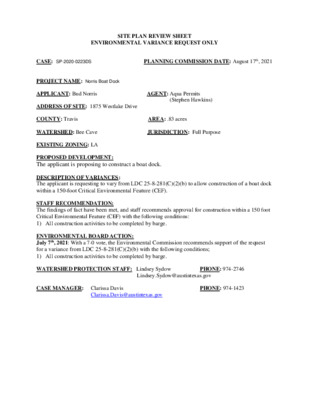
SITE PLAN REVIEW SHEET ENVIRONMENTAL VARIANCE REQUEST ONLY AREA: .83 acres PLANNING COMMISSION DATE: August 17th, 2021 CASE: SP-2020-0223DS PROJECT NAME: Norris Boat Dock APPLICANT: Bud Norris AGENT: Aqua Permits (Stephen Hawkins) ADDRESS OF SITE: 1875 Westlake Drive COUNTY: Travis WATERSHED: Bee Cave JURISDICTION: Full Purpose EXISTING ZONING: LA PROPOSED DEVELOPMENT: The applicant is proposing to construct a boat dock. DESCRIPTION OF VARIANCES: The applicant is requesting to vary from LDC 25-8-281(C)(2)(b) to allow construction of a boat dock within a 150-foot Critical Environmental Feature (CEF). STAFF RECOMMENDATION: The findings of fact have been met, and staff recommends approval for construction within a 150 foot Critical Environmental Feature (CEF) with the following conditions: 1) All construction activities to be completed by barge. ENVIRONMENTAL BOARD ACTION: July 7th, 2021: With a 7-0 vote, the Environmental Commission recommends support of the request for a variance from LDC 25-8-281(C)(2)(b) with the following conditions; 1) All construction activities to be completed by barge. WATERSHED PROTECTION STAFF: Lindsey Sydow PHONE: 974-2746 Lindsey.Sydow@austintexas.gov CASE MANAGER: Clarissa Davis Clarissa.Davis@austintexas.gov PHONE: 974-1423 ENVIRONMENTAL COMMISSION MOTION 20210707 003a Date: July 7, 2021 Subject: Norris Boat Dock, SP-2020-0223DS Motion by: Kevin Ramberg RATIONALE: WHEREAS, the Environmental Commission recognizes the applicant is requesting a variance from LDC 25- 8-281(C)(2)(B) to allow construction within 150-feet of Critical Environmental Feature (Rimrock). WHEREAS, the Environmental Commission recognizes that staff recommends this variance (with one condition) having determined the required Findings of Fact have been met. Seconded by: Andrew Creel THEREFORE, the Environmental Commission recommends the variance request with the following Staff Condition: 1. Construction to be completed by barge. VOTE 7-0 For: Creel, Thompson, Brimer, Ramberg, Barrett Bixler, Bristol, and Guerrero Against: None Abstain: None Recuse: None Absent: Coyne and Bedford Approved By: Linda Guerrero, Environmental Commission Chair 1 ITEM FOR ENVIRONMENTAL COMMISSION AGENDA July 7, 2021 Norris Boat Dock SP-2020-0223DS Stephen Hawkins, Aqua Permits, LLC COMMISSION MEETING DATE: NAME & NUMBER OF PROJECT: NAME OF APPLICANT OR ORGANIZATION: LOCATION: ENVIRONMENTAL REVIEW STAFF: WATERSHED: REQUEST: COUNCIL DISTRICT: District #10 1875 Westlake Dr. Lindsey Sydow, P.G. Lake Austin and Bee Creek Watershed, Water Supply Rural, Drinking Water Protection Zone Request to vary from LDC 25-8-251(C)(2)(b) to allow construction of a boat dock within 150 feet of a Canyon Rimrock Critical Environmental Feature (CEF). STAFF RECOMMENDATION: Staff recommends this variance with conditions, having determined the findings of fact to have been met. STAFF CONDITION: All construction …
1875 WESTLAKE DR NORRIS BOAT DOCK SP-2020-0223DS Lindsey Sydow Hydrogeologic Reviewer Watershed Protection Department PROPERTY DATA • BEE CREEK WATERSHED • WATER SUPPLY RURAL CLASSIFICATION • CANYON RIMROCK CRITICAL ENVIRONMENTAL FEATURE ON SITE • COUNCIL DISTRICT 10 BACKGROUND • • • BOAT DOCK ON LAKE AUSTIN (BEE CREEK) DOWNSLOPE FROM CANYON RIMROCK UPDATING OLD BOAT DOCK CODE REFERENCE •TITLE 25 – LAND DEVELOPMENT CODE, CHAPTER 25-8-281(C)(2)(B). VARIANCE REQUEST REQUEST TO VARY FROM LDC 25-8- 281(C)(2)(B) TO ALLOW CONSTRUCTION WITHIN A CRITICAL ENVIRONMENTAL FEATURE (CEF) BUFFER. Canyon Rimrock Rimrock extends onto neighboring property • Dock construction is proposed at bottom of slope, with Limits of Construction (orange) as far from Rimrock CEF (purple) as is feasible. • No new shoreline access is proposed between house and new dock. VARIANCE RECOMMENDATION FINDING OF FACTS HAVE BEEN MET. STAFF RECOMMENDS THE APPROVAL OF THIS VARIANCE WITH THE CONDITION THAT ALL CONSTRUCTION BE COMPLETED BY BARGE. QUESTIONS? Existing Conditions
Regular Meeting of the Zoning and Platting Commission August 17, 2021 Zoning and Platting Commission to be held August 17, 2021 with Social Distancing Modifications Public comment will be allowed via telephone; no in-person input will be allowed. All speakers, including applicants and representatives, must register in advance (Day before the scheduled meeting, August 16, 2021 by noon. ) To speak remotely at the August 17, 2021 Zoning and Platting Commission Meeting, residents must: Preferably email Commission Liaison, Andrew Rivera at andrew.rivera@austintexas.gov or call 512-974-6508 (the day before the meeting). The following information is required: 1. The speaker name. 2. Item number(s) they wish to speak on. 3. Whether they are for/against/neutral. 4. Mailing address. 5. Telephone number. Must be the number that will be used to call-in. Failure to provide the required information by noon August 16, 2021 shall render a request null and void. automatically roll over. A registered speaker may not sign up another speaker. Previous registration on an item does not •Once a request to register to speak has been called in or emailed to the board liaison, residents will receive either an email or phone call with additional information regarding the call in process. •Handouts or other information must be emailed to andrew.rivera@austintexas.gov by 1:00 PM Tuesday August 17, 2021. This information will be provided to Commission members in advance of the meeting. •Residents may watch the meeting here: http://www.austintexas.gov/page/watch-atxn-live Time Allotment: Speakers: 3 minutes. Applicant: 6 minutes and 3 minutes rebuttal. Postponement requests must be submitted to the case manager and Andrew Rivera by 5PM Monday, August 16, 2021. Reunión de la Comisión de Zoning and Platting Fecha 17 de agosto de 2021 La Comisión de Zoning and Platting se reunirá el 17 de agosto de 2021 modificaciones de distanciamiento soial. Se permitirán comentarios públicos por teléfono; no se permitirá ninguna entrada en persona. Llame o envíe un correo electrónico al enlace de la junta en 512-974-6508 andrew.rivera@austintexas.gov a más tardar al mediodía (el día antes de la reunion, 16 de agosto 2021 . ) 1. El nombre del orador. 2. Número (s) de artículo sobre el que desean hablar. 3. Si están a favor / en contra / neutrales. 4. Dirección postal. 5. Número de teléfono. Debe ser el número que se utilizará para llamar a la persona que desea hablar. Si la información solicitada no se envía antes del mediodía del 16 …