Final Budget Proposal for Enhanced Climate Resilience in Austin WHEREAS, The Human Rights Commission recognizes that access to clean air, water, and a stable climate is a fundamental human right, and Austin is experiencing increasingly severe climate impacts. In 2024, the city recorded the highest number of 100°F+ days in its history. WHEREAS, These extreme weather events, including destructive flooding, prolonged drought, and dangerous heat waves, affect disproportionately vulnerable communities. Austin's most vulnerable populations are largely concentrated on the east side, a result of early 20th-century segregation policies and the legacy of discriminatory practices. These communities are more likely to experience adverse outcomes due to socioeconomic status, race, ethnicity, and age, making them more susceptible to climate-related disasters. WHEREAS, Austin has committed to climate neutrality by 2040 through the Austin Climate Equity Plan, yet current funding levels are insufficient to meet this goal, and environmental injustice—the disproportionate exposure of marginalized communities, particularly low-income communities and communities of color, to environmental hazards, along with their systemic exclusion from environmental decision-making—further exacerbates these challenges; and the 2023 Annual Highlights report from the Office of Sustainability notes that the city surpassed $1 million in funds provided to Austin-area schools through the Bright Green Future Grants program, supporting 555 projects since 2012; however, more substantial investments are needed to accelerate progress toward climate neutrality. WHEREAS, Austin Energy's transition to renewable energy currently stands at 43% of its energy portfolio, falling short of the interim goal of 65% renewable energy by 2025. The 2020 generation plan indicates an aim to achieve 375 MW of local solar by the end of 2030, with 200 MW targeted for customer-sited installations. To meet these targets, increased investment in renewable energy infrastructure is essential. WHEREAS, Extreme weather events have exposed vulnerabilities in Austin's infrastructure. The Central Texas Extreme Weather and Climate Change Vulnerability Assessment highlights that future climate scenarios predict increased heavy rain events and severe droughts, potentially shifting Austin's climate to resemble the arid Southwest. This underscores the urgent need for investments in climate resilience and energy independence. WHEREAS, Rising temperatures and extended heat waves pose significant public health risks. Data indicates that 32.3% of residents reported five or more poor mental health days in 2021, up from 17% in 2011, highlighting the mental health challenges exacerbated by climate stressors. The National Weather Service reports that Austin has been warming at a rate of about 0.4°F per decade …
BOARD/COMMISSION RECOMMENDATION Human Rights Commission Recommendation Number: (YYYYMMDD-XXX) (XXX is the agenda item number): Budget Proposal for Increased Emergency Housing Assistance WHEREAS, the City of Austin is facing a housing affordability crisis as data reports show that the overall median rent is now $1,995.00, with the median rent for a one bedroom at $1,387.00 which is 6.4% more expensive than the national average. WHEREAS, even though median rent has fallen in the past year, rental prices are still unsustainable; especially given that the cost of living for Austinites has continued to increase due to national trends such as soaring healthcare costs, grocery bills, and child and dependent care. WHEREAS, Eviction filings in Austin JP Courts reached a record high of 13,210 filings in a single year in 2024, an increase of 26% from 2023, and the State Legislature is currently advancing a bill to weaken what little rights tenants already possess in the state of Texas. WHEREAS, per the Eviction Lab at Princeton University, eviction filings in Austin have soared to over 50% higher than the pre-pandemic average rate, with communities of color drastically more at risk of eviction in a state with some of the country’s weakest protections for renters. WHEREAS, a record 2.1 million renters, more than half of the state’s renter households, are “cost burdened,” meaning they spend more than 30% of their income on rent and utilities per a recent Harvard University study. WHEREAS, the State of Texas shuttered its statewide rent relief program in the summer of 2023 leaving it up to municipalities to act on the growing rental crisis. Austin has stepped up to the plate, most recently in last year’s budget cycle with a $8 million rental assistance and eviction support program through the City of Austin Housing Department’s “I Belong in Austin” program. NOW, THEREFORE, BE IT RESOLVED that the Human Rights Commission encourages the Austin City Council to allocate at least another $8 million dollars in rental relief funds and explore all available means in order to create short, medium, and long term solutions for individuals at risk of eviction in Austin. Date of Approval: _____________________________ Record of the vote: Attest: _____________________________________________
This template is a guide for liaisons. COMMISSION RECOMMENDATION Human Rights Commission Recommendation Number: (20250324-TBD): Budget Recommendation Providing Funding for Community Dialogues in the City of Austin WHEREAS, the City Charter outlines that the Austin Human Rights Commission shall “initiate and facilitate discussions and negotiations between individuals and groups to lessen tensions and improve understanding in the community”; and, WHEREAS, the City Charter also outlines that the Austin Human Rights Commission shall, “institute and conduct educational programs to promote equal treatment, opportunity and understanding”; and, WHEREAS, the City Charter further outlines that the Austin Human Rights Commission shall “sponsor meetings, institutes, forums, and courses of instruction to lead to a clearer understanding and solution of human relations problems”; and, WHEREAS, pursuant to the City Charter, the Human Rights Commission formed a working group, the Intergroup Relations Working Group, for these purposes on January 27, 2025; and, WHEREAS, the working group shall propose that a series of up to 8 community dialogue sessions which will provide training, resources, and opportunities to bridge divides around topics related to immigration- based and other kinds of discrimination; and, WHEREAS, these dialogues have the potential to incur costs related to venue, travel, supplies, snacks, printing, and other preparatory materials. NOW, THEREFORE, BE IT RESOLVED that the Human Rights Commission encourages the Austin City Council to allocate $7,500 from the FY25 budget to aid in hosting up to 8 community dialogue sessions that promote greater understanding among members of our community who face discrimination related to immigration and other marginalized identities.
COMMISSION RECOMMENDATION Human Rights Commission Recommendation Number: (YYYYMMDD-XXX) (XXX - agenda item number): Budget Recommendation Providing Funding for Printing and Distribution of "Know Your Rights" Red Cards at Austin Public Library Sites WHEREAS, the City Charter outlines that the Austin Human Rights Commission shall “initiate and facilitate discussions and negotiations between individuals and groups to lessen tensions and improve understanding in the community”; and, WHEREAS, the City Charter also outlines that the Austin Human Rights Commission shall “institute and conduct educational programs to promote equal treatment, opportunity and understanding”; and, WHEREAS, public libraries serve as trusted and accessible community spaces where residents can receive critical information about their rights, particularly those related to immigration, law enforcement interactions, and workplace protections; and, WHEREAS, organizations such as the Immigrant Legal Resource Center and other advocacy groups have developed "Know Your Rights" red cards to help individuals understand their constitutional rights in various situations, including interactions with law enforcement and immigration officials; and, WHEREAS, ensuring that all Austin Public Library locations have printed "Know Your Rights" red cards available in multiple languages will empower community members with important legal information and contribute to greater public awareness and safety; and, WHEREAS, the costs associated with printing and distributing these materials include design, translation, printing, and distribution across all Austin Public Library branches. BE IT FURTHER RESOLVED, that the Human Rights Commission encourages the Austin City Council to allocate $25,000 from the FY25 budget to the Austin Public Library for the printing and distribution of "Know Your Rights" red cards at all library locations, ensuring that critical legal information is accessible to all community members. Date of Approval: ___________________________ Record of the vote: __________________________ Attest: _____________
Budget Proposal for a High School to Technical/Trade School to City Workforce Pipeline Program WHEREAS, The City of Austin has implemented programs like the Austin Youth Development (AYD) Program, which provides youth development services focusing on personal development and employability skills for youth aged 17-22, including educational and developmental activities within a year-long City work experience. WHEREAS, The Economic Development Department’s Workforce Development Program manages multiple, multiyear service delivery contracts with local nonprofit organizations to provide free or low-cost workforce training to individuals pursuing self-sustaining employment. WHEREAS, The Austin Chamber of Commerce supports funding for student success and programs that enhance workforce training, including a high school internship program with Austin ISD. WHEREAS, This initiative directly supports the mission of the Austin Human Rights Commission by promoting equal employment opportunities and reducing systemic barriers to workforce access for historically marginalized communities. WHEREAS, Despite these initiatives, there remains a need for a structured pipeline that directly connects high school students to technical/trade schools and subsequently to employment within City of Austin departments, addressing both workforce needs and providing clear career paths for students. WHEREAS, Other cities have successfully implemented similar programs. For instance: ● Philadelphia introduced a program that gives job priority to students in trade schools, leading to successful hires within city departments. ● New Orleans established the New Orleans Career Center (NOCC), offering career and technical education to high school students, providing training and certifications in fields such as building trades, culinary arts, digital media, and healthcare. ● Chicago’s City Colleges launched the College to Careers program, partnering with industry leaders to align curricula with workforce needs, effectively creating a pipeline from education to employment in high-demand sectors. NOW, THEREFORE, BE IT RESOLVED: The Human Rights Commission of the City of Austin recommends that the City Council allocate $2.5 million to establish a High School to Technical/Trade School to City Workforce Pipeline Program to: 1. Create Paid Apprenticeships & Pre-Apprenticeship Programs – $1,000,000 a. Establish paid internships and apprenticeships within city departments for high school juniors and seniors interested in skilled trades. b. Provide summer pre-apprenticeship programs for students exploring public works, electrical, HVAC, plumbing, cybersecurity, transportation, emergency services, and other high-demand fields. c. Offer stipends and tuition assistance for students enrolling in trade schools and certification programs at Austin Community College and local technical institutions. 2. Expand Dual Credit & Trade School Partnerships – $750,000 a. Partner with …
Budget Proposal for Improving the Accuracy and Effectiveness of the Austin Point-In-Time (PIT) Count WHEREAS, The annual PIT Count is a critical tool for assessing the scale of homelessness in Austin and securing federal funding, yet it has long been criticized for undercounting due to methodological challenges, volunteer limitations, and the transitory nature of homelessness. WHEREAS, Unhoused individuals in non-sheltered locations—such as encampments, wooded areas, and vehicles—are often missed, leading to inaccurate data that impacts funding and resource distribution. WHEREAS, The COVID-19 pandemic, housing crisis, and economic instability have increased the number of people experiencing homelessness, making accurate data collection more essential than ever. WHEREAS, Community organizations, advocacy groups, and policy leaders have called for more precise, real-time data collection efforts to better understand the causes, demographics, and needs of Austin’s unhoused population. NOW, THEREFORE, BE IT RESOLVED The Human Rights Commission of the City of Austin recommends the City Council allocate $750,000 in funding to improve the methodology, accuracy, and impact of the PIT Count through the following initiatives: 1. Enhanced Technology and Real-Time Data Collection – $250,000 a. Develop and deploy a mobile app for PIT Count volunteers to capture real-time data, geotag encampment locations, and ensure accuracy. b. Expand the use of AI and machine learning in collaboration with local universities and tech partners to predict trends in homelessness and improve counting methods. c. Fund heatmaps and GIS tools to better identify high-density areas and track displacement patterns throughout the year. 2. Expanded Volunteer Training and Outreach – $200,000 a. Provide stipends to train outreach teams and ensure PIT Count volunteers are well-prepared to engage with unhoused individuals. b. Expand collaboration with lived experience consultants (unhoused/formerly unhoused individuals) to refine data collection approaches and improve survey effectiveness. Increase partnerships with community-based organizations, such as Mobile Loaves & Fishes and ECHO Austin, to ensure better outreach and participation. c. 3. Incentives for Participation and Data Accuracy – $150,000 a. Implement a small compensation program (e.g., gift cards, meals, or basic supplies) for unhoused individuals who participate in the survey to encourage honest responses. b. Provide funding for follow-up surveys throughout the year, ensuring a more continuous and accurate count rather than a one-time snapshot. 4. Specialized Focus on Uncounted Populations – $150,000 a. Expand PIT Count efforts beyond traditional methods to capture harder-to-reach b. Individuals in informal housing situations (couch-surfing, motels, car-living, etc.). c. Youth and LGBTQ+ unhoused …
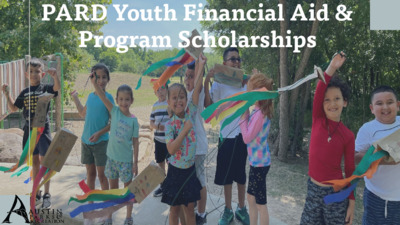
PARD Youth Financial Aid & Program Scholarships Goal: Increase Low-income Access to PARD Programs Establishment of Parks & Libraries Fund PARD began offering Financial Aid to qualified residents – 50% discount on registration fees Introduction of Youth Scholarship – additional 25% discount on youth programs Introduction of AE CAP program and auto-renewals 2014 2015 2016 2020 2023 2024 Moved to a revenue forgiveness model Moved to a 2-year renewal cycle. Application available in 5 additional languages Increase scholarship amounts to $700/child 2 Accomplishments Partnerships • Austin Energy: Auto-Renewals w/Customer Assistance Program • Austin Parks Foundation: Significant donation to fund • AISD: Community Eligibility Provision for auto-enrollment Reduction of Barriers • Two-year renewal cycle along with auto-renewals • Online application • Multi-Language application • Early registration process for summer camp programs Expanded Opportunities • Increase scholarship amounts • Removed limits on scholarship funds 3 • New scholarship payment option with online registration Early Enrollment Trends Year 2022 2023 2024 2025 % FA 16% 18% 29% 42% 4 Scholarship Funds Utilization Year 2022 2023 2024 Utilization Rate 64% 25% 81% 5 Impact in Numbers (Insert increase in total households enrolled in financial aid program) 1,105 participants approved for Financial Aid 400%more families awarded scholarships than in 2022 $700 equals 10 Weeks of summer camp programs 42% of early summer camp enrollment (needs rewording) $100,000 yearly donation by Austin Parks Foundation ____ households receive auto-renewals in the program 6 19% of program enrollments receive financial assistance “We really appreciated receiving the scholarship. It helped out a lot, and early registration allowed us to get what we needed. We both work, so summers are tough, and our son loves your camps!” Thank you! “I'm very thankful that the city offers this. It's a huge stress relief knowing that I can afford summer camp and basketball for my kids.” “This was a lifesaver at a very difficult time in our lives. I was unemployed, our house was under construction, and we unexpectedly took in a fourth child who was extremely emotionally unstable. Being able to afford programs that would offer consistency to the kids was huge.” “Me and my child were fortunate and very grateful to be able to participate in the scholarship program. Without that he wouldn’t have been able to go to camp. Thank you again and I really appreciate the opportunity.” “This helped my family so much. Thank you, it’s a blessing!” …
Ball and Soccer Field Contracts Special Request Presentation to the Parks and Recreation Board Monday March 24, 2025 Background • Parks Board issued related recommendation in October 2024 (20241028-5) • CM Pool and MPT Fuentes sponsored the special request project • Special requests are designed to answer specific questions to assist Council in decision-making • We do not draw conclusions or make recommendations in these reports Objective 1. 2. 3. Provide information about the existing contracts and associated amendments between the City and external organizations that manage, maintain, or use City-owned baseball and soccer fields, including: a) b) c) Number of contracts in effect; Organizations or entities with which the City is contracting; and Start and end dates of each contract and any options for renewal or extension. Provide information about the terms of each contract and associated amendments related to public and community access, including: a) Details in the contracts about level and schedule of access to the general public and how the public is notified about access; and, Details in the contracts as to how often the fields are available to the general public versus reserved for the contracted organization. b) Provide information about the terms and conditions in each contract and associated amendments related to breaches of contract and any procedures for terminating contracts in the event of a material breach, especially related to community access. 5questions Questions 1 & 2 How many active contracts does PARD have related to use of ball and soccer fields? 28 contracts Which organizations or entities does the City contract with to support recreation opportunities at ball and soccer fields? 25 organizations Question 3 What are the start and end dates for each contract? What are the options for renewal or extension for each contract? Contract Type Average Contract Length Minimum Contract Length Maximum Contract Length Contract Length in Years Athletic Field Use Agreements with Youth Sports Organizations Contractor Instructor Programs Facility Use & Maintenance Agreements Parkland Improvement & Land Use Agreements Youth Field Agreement for Athletic Facility Use 1.0 1.1 1.3 18.3 11.5 1.0 1.0 0.5 5.5 3.0 1.0 1.3 3.0 25.0 20.0 Start and End Dates Renewals and Extensions Athletic Field Use Agreements with Youth Sports Organizations Contractor Instructor Programs Facility Use and Maintenance Agreements Parkland Improvement and Land Use Agreements Question 4 Youth Field Agreement for Athletic Facility Use According to the contract language, how often are the …
PARKS AND RECREATION BOARD RECOMMENDATION 20250324-003 Project SAFE March 24, 2025 Seconded By: Holly Reed Date: Subject: Motioned By: Nicole Merritt Recommendation The Parks and Recreation Board recommends that Austin City Council approve the negotiation and execution of an interlocal agreement between the City of Austin and the Austin Independent School District for Project SAFE, a swim lesson and water safety education program that includes opportunities for students to continue their education by joining either paid or free swim lessons during the summer months when AISD is not in session. Rationale: This recommendation was referred to the Parks and Recreation Board by the Contracts and Concessions Committee on a 4-0 vote. Vote: The motion to recommend that Austin City Council approve the negotiation and execution of an interlocal agreement between the City of Austin and the Austin Independent School District for Project SAFE, a swim lesson and water safety education program that includes opportunities for students to continue their education by joining either paid or free swim lessons during the summer months when AISD is not in session was approved on Board Member Merritt’s motion, Board Member Reed’s second on 6-0 vote. Board Member Abou-Amara abstaining. Board Members Orme, Taylor and Villalobos absent. Stephanie Bazan, Lane Becker, Kathryn Flowers, Jennifer Franklin, Nicole Merritt, Holly Reed. Against: None. Abstain: Luai Abou-Emara. Absent: Shelby Orme, Kim Taylor, Pedro Villalobos. Attest: Tim Dombeck, Board and Council Liaison, Parks and Recreation Department. For:
PARKS AND RECREATION BOARD RECOMMENDATION 20250324-004 March 24, 2025 Seconded By: Nicole Merritt ACC Welding Interlocal Agreement Date: Subject: Motioned By: Lane Becker Recommendation The Parks and Recreation Board recommends that Austin City Council authorize the negotiation and execution of an interlocal agreement between the City of Austin and Austin Community College for restoration of the historic iron fencing surrounding family lots at Oakwood Cemetery. Rationale: This recommendation was referred to the Parks and Recreation Board by the Contracts and Concessions Committee on a 4-0 vote. Vote: The motion to recommend that Austin City Council authorize the negotiation and execution of an interlocal agreement between the City of Austin and Austin Community College for restoration of the historic iron fencing surrounding family lots at Oakwood Cemetery was approved on Board Member Becker’s motion, Board Member Merritt’s second on a 7-0 vote with one vacancy. Board Members Orme, Taylor and Villalobos absent. For: Luai Abou-Emara, Stephanie Bazan, Lane Becker, Kathryn Flowers, Jennifer Franklin, Nicole Merritt, Holly Reed. Against: None. Abstain: None. Absent: Shelby Orme, Kim Taylor, Pedro Villalobos. Attest: Tim Dombeck, Board and Council Liaison, Parks and Recreation Department.
Hotel Occupancy Tax Update Arts Commission Meeting March 24, 2025 Hotel Occupancy Tax – February 2025 Approved Budget Amended Budget February w/ Encumb Year-to-date w/Encumb Year-End Estimate Total Revenue $169,901,585 $169,901,585 $11,419,305 $73,124,589 $165,225,852 Transfer to Cultural Arts Fund $16,217,879 $16,217,879 $1,108,764 $7,001,619 $15,987,726 • Total HOT Collections February 2025 = $11,419,305 • 44% of FY25 Approved Budget of $169,901,585 • Cultural Arts Fund February 2025 = $1,108,764 C I TY O F A U S T I N HOT Cultural Arts Fund - FY25 C I TY O F A U S T I N Approved Budget for FY25: $16,217,879 FY25 HOT Cultural Arts Fund to date: $7,001,619 HOT Collections (FY22 – FY25) C I TY O F A U S T I N Questions? C I TY O F A U S T I N
Cultural Arts Funding Update March 24, 2025 Agenda 1. Contracts & Payments 2. FY 25 Cultural Funding Updates 3. Grant Funded Activities C I T Y O F A U S T I N Contracts & Payments FY23 Elevate FY23 Nexus (Fall/Winter) FY24 Nexus (Spring/ Summer) FY23-24 Thrive (Year 1) FY23-24 Thrive (Year 2) Contracts & Payments (As of 3/19/25) Total Contracts Signed & Processed Contracts Test payments issued & verified Payment 1 Issued Payment 2 Issued Payment 3 Issued 199 199 (100%) 199 (100%) 199 (100%) 197 (98%) 181 (91%) 51 51 (100%) 51 (100%) 51 (100%) 49 (96%) n/a 51 51 (100%) 51 (100%) 51 (100%) 44 (86%) n/a 36 36 (100%) 36 (100%) 36 (100%) 36 (100%) n/a See year 1 N/A N/A 35 (97%) 35 (100%) n/a Total Dist. to date Total Allocation $6,127,692 (96%) $6,250,000 $254,000 (99%) $255,000 $251,500 (100%) $255,000 $3,901,500 (100%) $3,901,500 (100%) $3,901,500 $3,901,500 *Each grant has a different reporting deadline. Final Payments are issued upon successful close out of Final Report. C I T Y O F A U S T I N FY 25 Cultural Funding Updates 551 applications received 100 grants 18% acceptance rate Awards announced mid- April Nexus Update 4 Spanish applications 547 English applications C I T Y O F A U S T I N FY 25 Nexus Timeline January 28, 2025 May 1, 2025 May 30, 2026 Nexus application opens Nexus activities begin Latest Nexus Final Report due date Nexus application closes Last day for Nexus activities March 6, 2025 April 30, 2026 C I T Y O F A U S T I N Elevate Update Limit Potential Funding Disruptions Launch goal of early Fall Maintain Goals established during Cultural Funding Review Process (Pilot Year 3) Address Legislative Impacts (State/Federal) Meaningfully Engage Community and Commission C I T Y O F A U S T I N Community Engagement Update Elevate • 6 participants • 5 responses Nexus Thrive • 16 participants • 10 responses • 12 participants • 3 responses Candice Cooper • ACME Chief of Staff • Community Engagement lead C I T Y O F A U S T I N Grant Funded Activities FY 24-25 Cultural Funding Grantee Activities Red Light Lit Austin: Visions • March 27 • Red Light Lit Austin – Propaganda HQ (Dist 2) Steven Hough: A Solo Piano Recital • March 28 • ATX Chamber Music …
Rally Austin Update March 2025 Commissions WHO WE ARE MISSION Facilitating equitable development for economic growth while preserving Austin's unique culture. VISION A culturally resilient and economically integrated Austin where diverse communities thrive without risk of displacement. LEADING INVESTMENTS IN OUR COMMUNITY, AS A COMMUNITY Rally will focus its efforts to unite and drive progress across three critical areas of development in Central Texas: ARTS, MUSIC & CULTURE COMPLETE COMMUNITIES CATALYTIC DEVELOPMENT 2 WHO WE ARE OUR COMMUNITY AT WORK Board of Directors Collaboration of community leaders and nominating bodies who represent local organizations and asset holders. 7 City Of Austin Representatives: • Music Commission • Arts Commission • Historic Landmark • +City Directors 3 INVESTMENT HIGHLIGHTS RALLY AUSTIN MILESTONES Council begins to explore collaboration Austin Economic Development Corporation established Signed Interlocal agreement for initial projects 21-person board created, CEO and Staff search begin Strategic Plan provides Board Structure and Mission $2.4M for two creative space projects on City owned property AEDC recognized as 501c3 Non- Profit Organization $4.5M announced for Austin Playhouse $1.6M Iconic Venue Funding for The Hole in the Wall AEDC rebrands as Rally Austin Austin City Council Approves Developer Selection, Urban Renewal Agency recommendation for Blocks 16 & 18 $2.5M for Museum of Human Achievement Council approves a 30% increase in the Interlocal Agreement 2014 2020 2021 2022 2023 2024 Arts, Music & Culture Complete Communities Catalytic Development 4 DEVELOPMENT FOR PURPOSE Critical Areas of Development for Central Texas COMPLETE COMMUNITIES ARTS, MUSIC & CULTURE CATALYTIC DEVELOPMENT 5 DEVELOPMENT FOR PURPOSE BLOCK 16 & 18 EAST 11th ST Development of complete communities that improve quality of life for Austinites and focus on equitable development in underserved areas. Blocks 16 & 18 in the African American Cultural Heritage District with the Urban Renewal Board Philanthropic partnerships with Wells Fargo, C3 Presents, and Six Square “ We are proud partners of the Rally Austin team and their transformative work ensuring communities throughout Austin can flourish. — CHRIS RIOS, WELLS FARGO REGIONAL VP OF PHILANTHROPY & COMMUNITY IMPACT ” 6 DEVELOPMENT FOR PURPOSE ARTS, MUSIC & CULTURE AUSTIN CULTURAL TRUST IMPACT $11M in five projects valued at $24.2M $11M $24.2M $48.4M to $60.5M Rally Investment Project Value Projected Economic Impact INVESTMENTS $1.6M Hole in the Wall $2M Permitting and Development Center $400K Millenium Youth Entertainment Complex $4.5M Austin Playhouse $2.5M Museum of Human Achievement $400K Millennium Youth Entertainment Complex …
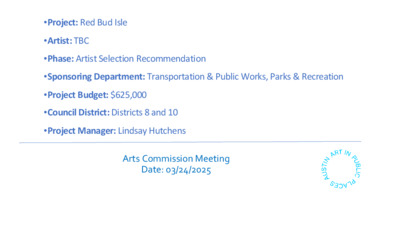
•Sponsoring Department: Transportation & Public Works, Parks & Recreation •Project: Red Bud Isle •Artist: TBC •Phase: Artist Selection Recommendation •Project Budget: $625,000 •Council District: Districts 8 and 10 •Project Manager: Lindsay Hutchens Arts Commission Meeting Date: 03/24/2025 Red Bud Isle Project Background Red Bud Isle is located off Redbud Trail between Lake Austin Boulevard and Stratford Drive. Red Bud Isle was formed in 1900 by the catastrophic collapse of the Great Granite Dam that contained Lake McDonald (now known as Lake Austin), killing several dozen people. Nearby is Tom Miller Dam that forms Lake Austin, the city’s primary source for drinking water. In 1940, the LCRA completed the dam as part of the Highland Lakes system, designed to manage floodwaters and bring electricity to the Texas Hill Country. Previous attempts to control the extreme flows of the Colorado had failed. In both 1900 and 1915 previous dams were devastated by floods. Granite boulders from those structures can still be found on Red Bud Isle. The Redbud Trail Bridge Project has been years in the making and is the result of increasing strains on the bridge due to flooding, population growth, the number of vehicles on the road and heightened use. The bridge, built in 1948, does not meet current roadway standards for traffic volume, bicycle and pedestrian amenities. The bridge is also nearing the end of its operational life. Construction of the new bridge is designed to handle current-day loading conditions, increasing vehicular traffic, and increased safety and multi-modal transportation options for bicyclists and pedestrians. The community stated a preference for artwork inspired by the history and nature of the site. Artists familiar with local ecology and/or the Red Bud Isle user community are highly encouraged to apply. Potential artwork locations are designated above, as well as other possible locations. Artwork may be considered for the bridge itself, however artwork may not pose any obstructions that block views of the water, impacts sight distance, interferes with pedestrian and vehicle activity, or the utility grate. AIPP in the area Red Bud Isle Budget – $625,000 Sponsor Department – Transportation & Public Works Selection Criteria • Technical quality and aesthetic appeal of Artwork Goals • A work of art of redeeming quality that advances public past work • Dedicated and consistent artistic practice • Authenticity, creativity, and innovation of work as presented • Communication of ideas and intentions • Ability and enthusiasm …
PARKS AND RECREATION BOARD RECOMMENDATION 20250324-005 March 24, 2025 Date: Subject: Motioned By: Kathryn Flowers Recommendation Fiscal Year 2025-2026 Budget Seconded By: Stephanie Bazan WHEREAS, the City of Austin Parks and Recreation Board Budget Working Group met over the course of several months, taking into account both Board member and resident input, as well as input from City of Austin Parks and Recreation Department (PARD) staff, and provided the Parks and Recreation Board with its unanimous recommendations; and WHEREAS, the Parks and Recreation Board notes that no finalized PARD FY 2026 Operating Budget is yet available, and as of now no Under Resourced Service Expectations are being solicited by PARD during this process; WHEREAS, the Parks and Recreation Board recognizes the demand for Parks and Recreation facilities, maintenance, programming, and safety measures will continue to grow significantly during the 2026 fiscal year, as it has the past several years; WHEREAS, Park Rangers had 41,914 contacts and managed 505 directed patrols at 36 different parks in FY24; WHEREAS, the City of Austin PARD has 378 parks in its system (excluding cemeteries), of which 36 parks represent only 9.5% of the system; WHEREAS, cemetery maintenance continues to be a challenge for existing PARD staff and the department is consistently understaffed for the maintenance requirements of the cemeteries under their purview, with 32 FTEs currently across the entire division and 7 vacancies; WHEREAS, according to a 2024 report by CoreLogic, Austin ranks fifth in number of homes with moderate or greater wildfire risk, with a reconstruction cost value of over $40 billion, and the number of homes at risk in the city is the highest of any metropolitan area outside of California; WHEREAS, most city parkland natural areas have not been managed for ecosystem health and are degraded, and as a result are threatened by heat, drought, disease, and wildfire and present safety risks to both park users and neighbors; WHEREAS, land management efforts within City of Austin PARD have been very successful where they have occurred and are ready for additional scaling to more quickly address areas of need across the system; WHEREAS, in 2020 PARD created a Land Management Program, which developed a land management plan approved by City Council in 2023 to guide the restoration of natural areas to improve climate resilience and reduce wildfire risk; WHEREAS, this Land Management Program program is currently underfunded, with a budget of only …