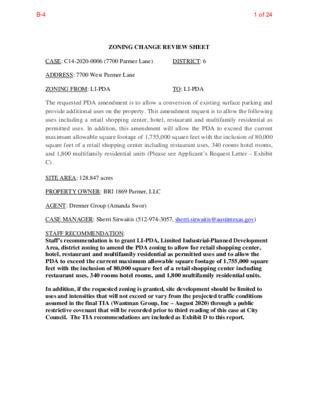
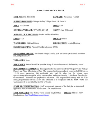
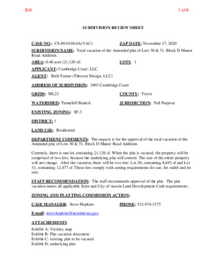
ZONING CHANGE REVIEW SHEET CASE: C14-2020-0111 (Vineyard Christian Fellowship of Austin, Texas, Inc.) DISTRICT: 6 ZONING FROM: I-RR ADDRESS: 13208 Morris Road SITE AREA: 8.47 acres (368,953.2 sq. ft.) TO: Tract 1: MF-2 Tract 2: GR PROPERTY OWNER: Vineyard Christian Fellowship of Austin, Texas, Inc. (Benjamin Koch) AGENT: Mathias Company (Richard Mathias) CASE MANAGER: Sherri Sirwaitis (512-974-3057, sherri.sirwaitis@austintexas.gov) STAFF RECOMMENDATION: Staff recommends MF-2, Multifamily Residence-Low Density District, zoning for Tract 1 and LO-MU, Limited Office-Mixed Use Combining District, zoning for Tract 2. ZONING AND PLATTING COMMISSION ACTION / RECOMMENDATION: November 17, 2020: Postponed to December 15, 2020 at the neighborhood's request by consent (10-0), N. Barrera-Ramirez-1st, A. Denkler-2nd. December 15, 2020 CITY COUNCIL ACTION: ORDINANCE NUMBER: 1 of 21B-1 C14-2020-0111 ISSUES: 2 The applicant provided the following additional information regarding the property (Exhibit C): 1. This property was subdivided in 2008 (C8J-2008-0107.0A - please see Related Cases below) and dedicated nearly 17 feet of land area for the future expansion of Morris Road. This dedication was to accommodate a planned 70-foot ROW for Morris Road and included 35 feet from the existing centerline. 2. At the time of Plat, a sidewalk was required along the entire frontage of Morris Road. This sidewalk has been built and is existing. 3. At the time of Plat, the owner of the property posted fiscal for future improvements to Morris Road. 4. The Plat that was approved by the City of Austin restricts land uses to non-residential only. See plat note 22. The applicant will be re-subdividing this property and that note will be removed or amended to allow the multi-family portion to be developed. CASE MANAGER COMMENTS: The property in question consists of two tracts of land that front onto Morris Road. Tract 1 (4.91 acres) is an undeveloped area and Tract 2 (3.25 acres) is developed with a religious assembly use with associated parking. To the north of the property there is an Outdoor Sports and Recreation (Town & Country Sports - Miracle Field) that is does not have permanent zoning (I-RR). The lot to the south is zoned GR-CO and is developed with a commercial retail center. The properties to the east and west are developed with single family/duplex residential uses (I-SF-2). The staff recommends MF-2, Multifamily Residence-Low Density District, zoning for Tract 1 and LO-MU, Limited Office-Mixed Use Combining District, zoning for Tract 2. The property in question is located …
ZAP COMMISSION DATE: 12/15/2020 SITE PLAN REVIEW SHEET ENVIRONMENTAL VARIANCE REQUEST ONLY AGENT: Tammi Migl CASE: SP-2020-0321C PROJECT NAME: Applied Materials Logistics Service Center APPLICANT: Migl Engineering ADDRESS OF SITE: 9614 E US 290 Hwy, Austin, TX, 78724 COUNTY: Travis WATERSHED: Decker Creek EXISTING ZONING: LI / LI-CO / PUD PROPOSED DEVELOPMENT: Warehouse with associated improvements DESCRIPTION OF VARIANCE: The applicant requests the following: JURISDICTION: Full Purpose AREA: 1. Request to vary from LDC25-8-341 to allow cut to 12 feet. 44.5 acres (LOC) STAFF RECOMMENDATION: Staff finds that the required findings of fact have been met and recommends the variance request. Staff recommends the following condition: applicant will stockpile and preserve topsoil for reuse in landscape, wetland mitigation, and/or biofiltration areas. ENVIRONMENTAL BOARD ACTION: 12/2/2020: The Environmental Board voted to recommend the variance request, with the staff condition, nine (9) favor, zero (0) against, zero (0) absentia. ZONING AND PLATTING COMMISSION ACTION: ENVIRONMENTAL REVIEW STAFF: Pamela Abee-Taulli CASE MANAGER: Anaiah Johnson PHONE: 512-974-2932 PHONE: 512-974-1879 1 of 38B-2 ENVIRONMENTAL COMMISSION MOTION 20201202 002c Subject: Applied Materials Logistics Service Center, SP-2020-0321C Motion by: Kevin Ramberg Seconded by: Pam Thompson Date: December 2, 2020 RATIONALE: WHEREAS, the Environmental Commission recognizes the applicant is requesting a variance from LDC 25-8-341 to allow cut to 12 feet; and WHEREAS, the Environmental Commission recognizes that staff recommends this variance (with one staff condition) having determined the required Findings of Fact have been met. THEREFORE, the Environmental Commission recommends the variance request with the following; 1. Applicant will stockpile and preserve topsoil for reuse in landscape, wetland mitigation, and/or biofiltration areas. Staff Condition: VOTE 9-0 For: Smith, Thompson, Neely, Coyne, Maceo, Ramberg, Guerrero, Gordon, Bedford Against: None Abstain: None Recuse: None Absent: Creel, Nill Approved By: Linda Guerrero, Environmental Commission Chair 1 2 of 38B-2 Development Services Department Staff Recommendations Concerning Required Findings Project Name: Ordinance Standard: Watershed Protection Ordinance Variance Request: Applied Materials Logistics Service Center Vary from LDC 25-8-341 to allow cut to 12 feet Include an explanation with each applicable finding of fact. A. Land Use Commission variance determinations from Chapter 25-8-41 of the City Code: 1. The requirement will deprive the applicant of a privilege available to owners of similarly situated property with approximately contemporaneous development subject to similar code requirements. Yes The applicant intends to combine multiple warehouses into one consolidated warehouse at this location. Automated robotic equipment and human operated …
ZONING AND PLATTING COMMISSION SITE PLAN VARIANCE AND COMMISSION APPROVAL REVIEW SHEET SPC-03-0005C(R2) ZAP DATE: 12/15/2020 3602-1/2 Redbud Trail Unit C Bee Creek, Little Bee Creek, Lake Austin (Suburban) City of Austin MWM Design (512) 689-3289 CASE NUMBER: PROJECT NAME: Albert H. Ullrich Water Treatment Plant ADDRESS: APPLICANT: AGENT: CASE MANAGER: Jeremy Siltala (512) 974-2945 or jeremy.siltala@austintexas.gov WATERSHED: APPLICATION REQUEST: The applicant is requesting 7 environmental variances for proposed improvements including critical upgrades to replace aging equipment, improve environmental controls and safety. Additionally, sites zoned Public (P) with limits of construction greater than one acre in size are a Conditional Use that require Land Use Commission approval according to LDC section 25-2-625. PROJECT DESCRIPTION: The applicant is proposing installation of Process Drain and Support Services and Low Service Pump Station Electrical Feed Renewal Project. SUMMARY STAFF COMMENT: This is an urgent City project to replace aging critical infrastructure. STAFF RECOMMENDATION: Staff recommends approval of the variances and conditional use permit request. The site plan will comply with all other requirements of the Land Development Code prior to its release. PROJECT INFORMATION: SITE AREA ZONING LAND USE BUILDING HEIGHT F.A.R VEHICULAR ACCESS PARKING 141.29 acres or 6,154,546 SF Public (P) Water Treatment Plant N/A N/A N/A 44 automobile NEIGHBORHOOD ORGANIZATIONS: Austin Lost and Found Pets Austin Neighborhoods Council Bike Austin City of Rollingwood Friends of Austin Neighborhoods Neighborhood Empowerment Foundation Preservation Austin SELTexas Save Barton Creek Assn. Save Our Springs Alliance Sierra Club, Austin Regional Group TNR BCP - Travis County Natural Resources 1 of 4 SPC-03-0005C(R2) CONDITIONAL USE PERMIT REVIEW AND EVALUATION CRITERIA The following evaluation is included to provide staff position on each point of the conditional use permit criteria. Section 25-5-145 of the Land Development Code states: “The Commission shall determine whether the proposed development or use of a conditional use site plan complies with the requirements of this section. Albert H. Ullrich Water Treatment Plant Page 2 A conditional use site plan must: title. 1. Comply with the requirements of this title; Staff response: This application complies with the requirements of this 2. Comply with the objectives and purposes of the zoning district; Staff response: This application complies with the objectives and purposes of the zoning district. 3. Have building height, bulk, scale, setback, open space, landscaping, drainage, access, traffic circulation, and use that are compatible with the use of an abutting site; Staff response: This application …
1 ENVIRONMENTAL COMMISSION MOTION 20201120 003b Subject: Albert H. Ullrich Water Treatment Plant, Revision 2, SPC-03-0005C(R2) Motion by: Kevin Ramberg Seconded by: Perry Bedford Date: November 20, 2020 RATIONALE: WHEREAS, the Environmental Commission recognizes the applicant is requesting seven variances from code including: 1) LDC 25-8-261 to allow development in the Critical Water Quality Zone, and by extension in the Water Quality Transition Zone of a Water Supply Rural watershed in the Edwards Aquifer Recharge Zone South [LDC 25-8-452] for: a) Phase 2: switchgear enclosure, duct bank and access drive, and b) Phase 3: containment basin, electric building and related duct banks, sludge changeover facility, 6” water line; 2) LDC 25-8-281 to allow construction within a rimrock Critical Environmental Feature buffer for: a) Phase 2: duct bank and access drive; 3) LDC 25-8-301 to allow construction of a driveway on a slope with a gradient of more than 15 percent for: a) Phase 2: duct bank and access drive; 4) LDC 25-8-302(A)(1) to allow construction of a building on a slope with a gradient of more than 25 percent for: a) Phase 2: switchgear enclosure and b) Phase 3: sludge change-over facility; 5) LDC 25-8-341 to allow cut to sixteen (16) feet for: a) Phase 3: containment basin; 6) LDC 25-8-342 to allow fill to twelve (12) feet for: a) Phase 2: duct bank and access drive; and 7) LDC 25-8-423(C)(1)(a) to allow impervious cover to exceed the 20 percent limit for development in the uplands of a Water Supply Suburban watershed. WHEREAS, the Environmental Commission recognizes that Staff recommends this variance (with conditions) having determined the required Findings of Fact have been met. THEREFORE, the Environmental Commission recommends the variance request with the following; 1 of 42 Staff Conditions: electric station. VOTE 9-0 1. Applicant has designed permanent diversion and dissipation for the existing concentrated flow from the 2. Applicant has designed the rain gardens to avoid and preserve significant trees and has agreed to revegetate the rain gardens with native plants. 3. Applicant has redesigned the proposed road to preserve the wetland at the base of the rimrock. For: Gordon, Nill, Neely, Bedford, Thompson, Smith, Guerrero, Coyne, Ramberg Against: None Abstain: None Recuse: None Absent: Creel, Maceo Approved By: Linda Guerrero, Environmental Commission Chair 2 2 of 42 MEMORANDUM TO: Linda Guerrero, Chair, Environmental Commission FROM: Pamela Abee-Taulli, Environmental Review, DSD DATE: October 21, 2020 SUBJECT: Albert H. …
ZONING AND PLATTING COMMISSION SITE PLAN CONDITIONAL USE PERMIT REVIEW SHEET ZAP DATE: December 15, 2020 SPC-2020-0261A CASE NUMBER: PROJECT NAME: Dell Children's Medical Center North ADDRESS OF APPLICATION: 9010 North Lake Creek Parkway APPLICANT: Ascension Seton 1300 West 34th Street Austin, TX 78705 AGENT: GarzaEMC, LLC. , Joe M. Farias 9442 N Cap. Of Texas Hwy Plaza 1, Ste 315 Austin, TX 78759 (512) 298-3284 23.73 acres (512) 974-2784 Buttercup Creek (Suburban) Rosemary.avila@austintexas.gov CASE MANAGER: Rosemary Avila AREA: COUNCIL DISTRICT: 6 WATERSHED: WATERSHED ORDINANCE: Comprehensive Watershed Ordinance C.I.P. STATUS: N/A T.I.A.: N/A CAPITOL VIEW: N/A PROPOSED DEVELOPMENT: The applicant is requesting a Conditional Use Permit for Hospital Services (General) land use. All construction for this site will be permitted under a separate B site plan permit, this application is for the approval of the the land use only. The development consists of one hospital building, one medical office building, parking, sidewalks, and other associated improvements. The proposed medical office use is a permitted use in the zoning district, only the hospital services use is a conditional use. The hospital services building will be 3 stories in height, 142,600 sq ft, and 36 beds. STAFF RECOMMENDATION: Staff recommends approval of the Conditional Use Permit for the proposed hospital services use. This site plan will comply with all Land Development Code requirements. PROJECT INFORMATION: 23.73 acres ALLOWED F.A.R.: 2:1 MAX. BLDG. COVERAGE: 95% MAX. IMPERVIOUS CVRG.: 95% REQUIRED PARKING: 398 PROPOSED ACCESS: North Lakecreek Parkway and US 183 SUMMARY COMMENTS ON SITE PLAN: Land Use: The proposed land use Hospital Services (General) is a conditional use in the CS (Commercial Services) base zoning district. All comments will be cleared prior to a land use permit is issued. This permit approval is pending the approval of the subdivision replat. This site is not subject to compatibility standards. EXIST. ZONING: CS- MU PROPOSED F.A.R.: 0.20:1 PROPOSED BLDG. CVRG: 8.9% PROPOSED IMPERVIOUS CVRG: 52.8% PROVIDED PARKING: 610 1 of 11B-7 ABUTTING STREETS North: East: South: West: Street IH 183 Avery Ranch Blvd North Lake Creek Parkway Hema Drive SPC-2020-0261A Dell Children's Medical Center North 2 Environmental: The site is located in the Butter Creek watershed, which is classified as Suburban. The site is in the Desired Development Zone. All environmental comments have been cleared. Transportation: All comments are cleared. SURROUNDING CONDITIONS: Zoning (Land Use) Avery Ranch Blvd, then MF-4 (multifamily) North Lake Creek Parkway, …
Regular Meeting of the Zoning and Platting Commission December 15, 2020 Zoning and Platting Commission to be held December 15, 2020 with Social Distancing Modifications Public comment will be allowed via telephone; no in-person input will be allowed. All speakers, including applicants and representatives, must register in advance (Day before the scheduled meeting, December 14, 2020 by noon. ) To speak remotely at the December 15, 2020 Zoning and Platting Commission Meeting, residents must: Preferably email Commission Liaison, Andrew Rivera at andrew.rivera@austintexas.gov or call 512-974-6508 (the day before the meeting). The following information is required: 1. The speaker name. 2. Item number(s) they wish to speak on. 3. Whether they are for/against/neutral. 4. Mailing address. 5. Telephone number. Must be the number that will be used to call-in. Failure to provide the required information by noon December 14, 2020 shall render a request null and void. automatically roll over. A registered speaker may not sign up another speaker. Previous registration on an item does not •Once a request to register to speak has been called in or emailed to the board liaison, residents will receive either an email or phone call with additional information regarding the call in process. •Handouts or other information must be emailed to andrew.rivera@austintexas.gov by 1:00 PM Tuesday December 15, 2020. This information will be provided to Commission members in advance of the meeting. •Residents may watch the meeting here: http://www.austintexas.gov/page/watch-atxn-live Time Allotment: Speakers: 3 minutes. Applicant: 6 minutes and 3 minutes rebuttal. Monday, December 14, 2020 Postponement requests must be submitted to the case manager and Andrew Rivera by 5PM Reunión de la Comisión de Zoning and Platting Fecha 15 de diciembre de 2020 La Comisión de Zoning and Platting se reunirá el 15 de diciembre de 2020 con modificaciones de distanciamiento soial. Se permitirán comentarios públicos por teléfono; no se permitirá ninguna entrada en persona. Llame o envíe un correo electrónico al enlace de la junta en 512-974-6508 andrew.rivera@austintexas.gov a más tardar al mediodía (el día antes de la reunion, 14 de diciembre de 2020). 1. El nombre del orador. 2. Número (s) de artículo sobre el que desean hablar. 3. Si están a favor / en contra / neutrales. 4. Dirección postal. 5. Número de teléfono. Debe ser el número que se utilizará para llamar a la persona que desea hablar. Si la información solicitada no se envía antes del mediodía del 14 …
Case No.: (City use only) Environmental Resource Inventory For the City of Austin Related to LDC 25-8-121, City Code 30-5-121, ECM 1.3.0 & 1.10.0 The ERI is required for projects that meet one or more of the criteria listed in LDC 25-8-121(A), City Code 30-5-121(A). 1. SITE/PROJECT NAME: 2. COUNTY APPRAISAL DISTRICT PROPERTY ID (#’s): 3. ADDRESS/LOCATION OF PROJECT: 4. WATERSHED: 5. THIS SITE IS WITHIN THE (Check all that apply) Edwards Aquifer Recharge Zone* (See note below) .................. YES No Edwards Aquifer Contributing Zone*.................................. YES No Edwards Aquifer 1500 ft Verification Zone* ....................... YES No Barton Spring Zone* .......................................................... YES No *(as defined by the City of Austin – LDC 25-8-2 or City Code 30-5-2) Note: If the property is over the Edwards Aquifer Recharge zone, the Hydrogeologic Report and karst surveys must be completed and signed by a Professional Geoscientist Licensed in the State of Texas. 6. DOES THIS PROJECT PROPOSE FLOODPLAIN MODIFICATION?.......YES** NO If yes, then check all that apply: (1) The floodplain modifications proposed are necessary to protect the public health and safety; (2) The floodplain modifications proposed would provide a significant, demonstrable environmental benefit, as determined by a functional assessment of floodplain health as prescribed by the Environmental Criteria Manual (ECM), or (3) The floodplain modifications proposed are necessary for development allowed in the critical water quality zone under LDC 25-8-261 or 25-8-262, City Code 30-5-261 or 30-5-262. (4) The floodplain modifications proposed are outside of the Critical Water Quality Zone in an area determined to be in poor or fair condition by a functional assessment of floodplain health. ** If yes, then a functional assessment must be completed and attached to the ERI (see ECM 1.7 and Appendix X for forms and guidance) unless conditions 1 or 3 above apply. 7. IF THE SITE IS WITHIN AN URBAN OR SUBURBAN WATERSHED, DOES THIS PROJECT PROPOSE A UTILITY LINE PARALLEL TO AND WITHIN THE CRITICAL WATER QUALITY ZONE? ......................................................... YES*** NO ***If yes, then riparian restoration is required by LDC 25-8-261(E) or City Code 30-5-261(E) and a functional assessment must be completed and attached to the ERI (see ECM1.5 and Appendix X for forms and guidance). 8. There is a total of (#’s) Critical Environmental Feature(s)(CEFs) on or within150 feet of the project site. If CEF(s) are present, attach a detailed DESCRIPTION of the CEF(s), color PHOTOGRAPHS, the CEF WORKSHEET and …
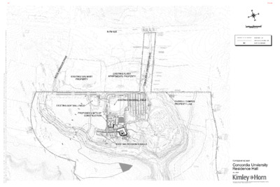
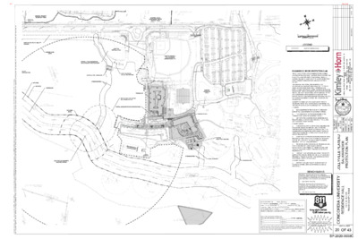
ZAP COMMISSION DATE: 12/15/20 SITE PLAN REVIEW SHEET ENVIRONMENTAL VARIANCE REQUEST ONLY AGENT: Brandon Hamman, P.E., LEED AP CASE: SP-2020-0038C PROJECT NAME: Concordia University Campus Residence Hall APPLICANT: Concordia University ADDRESS OF SITE: 11400 Concordia University Drive, 78726 COUNTY: WATERSHED: Bull Creek, Water Supply Suburban EXISTING ZONING: R&D-PDA PROPOSED DEVELOPMENT: Residence hall, associated parking lot and improvements. DESCRIPTION OF VARIANCE: The applicant requests the following: Request to vary from Lake Austin Watershed Ordinance No. 840301-F: JURISDICTION: Full Purpose AREA: 360.8 acres Travis - Section 9-10-409(a) – for a fill exceeding four feet - Section 9-10-409(b) – for a cut exceeding four feet STAFF RECOMMENDATION: Staff recommends that the required findings of fact have been met. ENVIRONMENTAL BOARD ACTION: 11/20/2020: The Environmental Board voted in (8) favor, (0) against, (1) recusal, (1) absentia ZONING AND PLATTING COMMISSION ACTION: ENVIRONMENTAL REVIEW STAFF: Kristy Nguyen, Environmental Review Specialist Senior, Development Services Department PHONE: 512-974-3035 CASE MANAGER: Renee Johns, Senior Planner, Development Services Department PHONE: 512-974-2711 1 of 34B-5 ENVIRONMENTAL COMMISSION MOTION 20201120 003a Subject: Concordia University Campus Residence Hall, SP-2020-0038C Motion by: Katie Coyne Seconded by: Wendy Gordon Date: November 20, 2020 RATIONALE: WHEREAS, the Environmental Commission recognizes the applicant is requesting a variance from the Lake Austin Watershed Ordinance No. 840301-F, LDC Chapter 9-10, Section 9-10-409(b) - for a cut exceeding four feet; WHEREAS, the Environmental Commission recognizes the applicant is requesting a variance from Lake Austin Watershed Ordinance No. 840301-F, LDC Chapter 9-10, Section 9-10-409(a) – for fill exceeding four feet; and WHEREAS, the Environmental Commission recognizes that staff recommends these variances (with conditions) having determined the required Findings of Fact have been met. THEREFORE, the Environmental Commission recommends the variance request with the following; Staff Conditions: 1. Subject to the Void and Water Flow Mitigation Rule (City Environmental Criteria Manual 1.12.0 and City Standards Specification Manual No. 658S) provision that all trenching greater than 5 feet deep must be inspected by a qualified Texas Professional Geoscientist or their representative; 2. Preserve the top 10 inches of topsoil to be used onsite; and 3. Increased tree mitigation and landscaping for areas of fill to stabilize erosion as shown on landscape plan submitted in this variance packet. VOTE 8-0 For: Gordon, Nill, Neely, Bedford, Thompson, Smith, Guerrero, Coyne Against: None Abstain: None Recuse: Ramberg Absent: Creel, Maceo 1 2 of 34B-5 Approved By: Linda Guerrero, Environmental Commission Chair 2 3 of 34B-5 …
N FM 620 E RIV D R U O B R A H K C O R R O C D O K ( 7 C 0 # ' H 2 R A 0 . 0 O R 0 . B 0 0 W O 0 . 2 W U 5 I R D T O H ) D P R T C R I V E R D O O C C # K 2 0 H 0 5 0 0 A R 2 B 7 O 5 O R P R D T R C . EXISTING WALMART PROPERTY EXISTING ALARA APARTMENTS PROPERTY E V I R D Y T I S R E V I N U A I D R O C N O C EXISTING SOFTBALL FIELD D V O R O A L I P R . N T 9 C 0 A 8 G 2 E , P E G A . 6 S 2 5 E M E N T PROPOSED LIMITS OF CONSTRUCTION D R A I N V A O L G . E 9 0 E 8 A S 2 , E M E O P P G R . 6 N T T 2 5 C P D R O E C S # E O 2 R P 0 V R 0 E 7 T T 1 C 0 R 6 A 6 1 3 C T F L 1 8 " R C R P ( I M S E = ) 9 = 9 5 4 4 8 . . 0 5 ± ± D F R I L M F F L L 1 2 8 = 4 " 9 1 8 " " R 5 R R C P C 3 . C P 2 P ( ± ( ( N S N E E ) W ) = = 9 ) = 9 4 9 4 4 6 6 . . 8 6 8 ± . 8 ± ± D F R I L M 1 = 8 " 9 R 5 C 5 . P 0 ± ( S W ) = 9 5 1 . 1 ± ET T TT T T T T T E E ET D R F I L M 1 = 8 " 9 R 3 C P 9 . 4 ± ( S W …
SEDIMENTATION WATER QUALITY/ EXISTING LIVE WATER QUALITY CHANNEL ORANGE ZONE (300 M) EXISTING SOFTBALL FIELD EXISTING BASEBALL FIELD, DUGOUTS, GRANDSTANDS, ETC. 150' CEF SPRING BUFFER 50' CWQZ 100' WQTZ CENTERLINE SOFTBALL FIELD UNDERDRAIN WATER QUALITY PRETREATMENT EXISTING LEVEL SPREADER EXISTING PARTIAL BIO-FILTRATION POND STREAM BUFFER PARKING LOT 150' RIM ROCK CEF BUFFER AND SPRING BUFFER PARTIAL SEDIMENTATION/FILTRATION POND EXISTING DETENTION POND RED ZONE (80 M) FILTRATION BASIN SEDIMENTATION BASIN DETENTION POND RESIDENCE HALL VAN T T U P EXISTING PARTIAL SED/FILL POND 2 ( D 0 ' O P C . U N . E . O . _ _ _ _ _ _ _ _ _ _ _ _ ) B I O F I L T R A T I O N B A S I N S E D I M E N T A T I O N B A S I N D E T E N T I O N P O N D PARTIAL BIO-FILTRATION POND JOLLYVILLE SALAMANDER OCCUPIED SPRING STREAM BUFFER LEVEL SPREADER STREAM BUFFER 3. WATER QUANTITY: 00 100' 200' GRAPHIC SCALE 100' LEGEND LIMITS OF CONSTRUCTION ENDANGERED SPECIES PROTECTION PLAN THE JOLLYVILLE PLATEAU SALAMANDER OCCUPIES A SPRING LOCATED ON THE CONCORDIA UNIVERSITY TEXAS PROPERTY AND IS LOCATED +/-800 FEET WEST OF THE SOFTBALL FIELD IN A NATURAL DRAINAGE CHANNEL LOCATED IN EXISTING PRESERVE LANDS OWNED BY CONCORDIA AND MANAGED BY TRAVIS COUNTY. THE ENGINEER, THE OWNER, AND ENVIRONMENTAL CONSULTANT, ACI, HAVE MET WITH USFWS AND THE CITY OF AUSTIN (COA) TO WORK TOGETHER IN DETERMINING AN EFFECTIVE SOLUTION FOR PROTECTING THE JOLLYVILLE PLATEAU SALAMANDER. THIS SALAMANDER IS LISTED AS AN ENDANGERED SPECIES. IMPLEMENTING THE MEASURES REQUIRED IN THE CITY OF GEORGETOWN'S WATER QUALITY MANAGEMENT PLAN (WQMP) EXHIBIT 'A' WAS DISCUSSED WITH THE USFWS AND CITY OF AUSTIN AS PROVIDING SUFFICIENT PROTECTION FOR THE SALAMANDER. IN ORDER TO COMPLY WITH THE WQMP AND TO PROVIDE ADDITIONAL PROTECTION FOR THE SALAMANDER SPRING SITE, THE FOLLOWING HAS BEEN IMPLEMENTED INTO THIS SITE PLAN: 1. BUFFERS: a. NO DEVELOPMENT IS PROPOSED IN THE “RED ZONE.” (80M UP AND DOWN STREAM FROM CENTER OF SPRING). b. THE DEVELOPMENT IS PROPOSED OUTSIDE OF THE “ORANGE ZONE” (300M FROM CENTER OF SPRING). c. 100-FOOT STREAM BUFFERS FROM CENTERLINE HAVE BEEN PROVIDED, WHICH COINCIDE WITH THE CITY OF AUSTIN WATER QUALITY TRANSITION ZONE. 2. WATER QUALITY: a. A LIVE CHANNEL THAT MEETS THE TCEQ REQUIREMENTS FOR CHANNEL DESIGN …
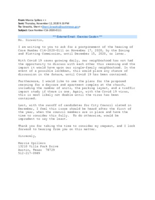
Dear Recipient, In May 2020, the City Council of the City of Austin passed a resolution regarding community resilience building and comprehensive resilience planning in order to create a more resilient Austin. As we work to amplify the City’s efforts universally to address societal shocks and stressors relevant to our community, we have begun to meet with community members so that together, we can begin to give shape to the comprehensive resilience planning effort of the City of Austin. I am writing to extend an invitation to your board, commission, or city group to attend our upcoming Community is Resilience event on December 16, 2020. At the event we will: 1) Provide an update on City of Austin resilience efforts, 2) Engage in interactive activities on shocks and stressors, and equity in comprehensive resilience planning. This event is part of a series of events with community members that will inform the focus and design of the City of Austin’s comprehensive resilience planning process. We invite you to send up to three members of your group to represent your group at this event. Because our mandate is to center equity in the comprehensive resilience planning process, we ask that whenever possible you select for attendance members of your boards, commissions and city groups that: • Are themselves from communities/groups that are most affected by societal shocks and stressors, • Work directly with communities/groups that are most affected by societal shocks and stressors, • Operate with/are versed in a strong equity lens. Title: Resilience Is Community – A Conversation with Austin Boards and Commissions Date: Wednesday, December 16, 2020 Time: 6:00 p.m. – 8:00 p.m. (CST) IS Resilience in Community A conversation w/ Austin Boards and Commissions Hosted by the City of Austin Resilience Wednesday, December 16, 2020 6:00 p.m. - 8:00 p.m. CST IN 2020, the City of Austin City Council passed a resolution on comprehensive community resilience building to create a more resilient Austin. Please join us for an update on the new resilience portfolio and interactive dialogue on Austin's resilience context that will help us shape comprehensive resilience planning in Austin! Registration Link: https://zoom.us/j/98849510988? pwd=T0xTMkNUU003RDF0d2t4bVFYaitPdz09
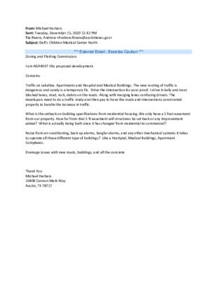
From: Michael Harbers Sent: Tuesday, December 15, 2020 12:42 PM To: Rivera, Andrew <Andrew.Rivera@austintexas.gov> Subject: Dell's Children Medical Center North *** External Email - Exercise Caution *** Zoning and Platting Commission I am AGAINIST this proposed development. Concerns Traffic on Lakeline. Apartments and Hospital and Medical Buildings. The new routing of traffic is dangerous and surely is a temporary fix. Drive the intersection for your proof. I drive it daily and incur blocked lanes, mud, rock, debris on the roads. Along with merging lanes confusing drivers. The developers need to do a traffic study and then pay to have the roads and intersections constructed properly to handle the increase in traffic. What is the setback on building specifications from residential housing. We only have a 5 foot easement from our property. How far from that 5 ft easement will structures be set back or any improvement added? What is actually being built since it has changed from residential to commercial? Noise from air conditioning, back up alarms, burglar alarms, and any other mechanical systems it takes to operate all these different type of buildings? Like a Hostiptal, Medical Buildings, Apartment Complexes. Drainage issues with new roads, buildings, and all the concrete Thank You Michael Harbers 10408 Cannon Mark Way Austin, TX 78717
Request for Initiation of Rezoning: 6610 Shelton Road December 15, 2020 Located in Districts 1 & 3 Not in Neighborhood Plan Area Current/Requested Entitlements Current Zoning: • SF-2 (Single-Family Residence Standard Lot) • Per §25-2-56, an SF-2 district is the designation for a moderate density single-family residential use. Proposed Zoning: • P (Public) • Per §25-2-145, a P district the designation for a governmental, civic, public service, or public institution use. A P district designation may be applied to a use located on property used or reserved for a civic or public institutional purpose or for a major public facility. is Site Summary Property Size: Access: • 1.53 acres, or approximately 66,603 SF • Shelton Drive • Local City Street roadway classification Environmental Features: • 100- and 500-year floodplain • Critical Water Quality Zone • Erosion Hazard Zone Easements: • Channel easement • Drainage easement • 20-foot-wide gas pipeline easement (unspecified location) Critical Water Quality Zone Floodplain Erosion Hazard Zone Drainage Easements LI-NP Regiene Rd. PDA Proposed Rezoning Property Size: - 15.69 acres (xx acres of developable land) - Easements - Compatibility - Topography Proposed Rezoning From: - SF-2-NP (Single-Family Residence Standard Lot – Neighborhood Plan) and LI-NP (Limited Industrial Services – Neighborhood Plan) To: - LI-PDA, Limited Industrial Services – Planned Development Area Uses: - Multifamily - Commercial - Light Industrial/Maker space Regiene Rd. Compatibility Impact Austin Energy Transmission Tower Austin Energy Easement Zoning Initiation Process Per LDC §25-2-242, a Land Use Commission may initiate the rezoning of a property. Initiation > Staff Review > ZAP Hearing > City Council Hearing Request We respectfully request that Zoning and Platting Commission initiate the rezoning of 6610 Shelton Road to “P” Public zoning designation.
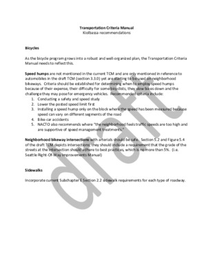
Transportation Criteria Manual Kiolbassa recommendations Bicycles As the bicycle program grows into a robust and well-organized plan, the Transportation Criteria Manual needs to reflect this. Speed humps are not mentioned in the current TCM and are only mentioned in reference to automobiles in the draft TCM (section 3.3.0) yet are starting to be used on neighborhood bikeways. Criteria should be established for determining when to employ speed humps because of their expense, their difficulty for some bicyclists, they slow bikes down and the challenge they may pose for emergency vehicles. Recommended criteria include: 1. Conducting a safety and speed study 2. Lower the posted speed limit first 3. Installing a speed hump only on the block where the speed has been measured because speed can vary on different segments of the road 4. Bike-car accidents 5. NACTO also recommends where “the neighborhood feels traffic speeds are too high and are supportive of speed management treatments.” Neighborhood bikeway intersections with arterials should be safe. Section 5.2 and Figure 5.4 of the draft TCM depicts intersections; they should include a requirement that the grade of the streets at the intersection should adhere to best practices, which is no more than 5%. (i.e. Seattle Right-Of-Way Improvements Manual) Sidewalks Incorporate current Subchapter E Section 2.2 sidewalk requirements for each type of roadway. From: To: Subject: Date: King, David - BC Rivera, Andrew Re: Item C-3 - Transportation Criteria Manual - Comments Friday, December 11, 2020 1:51:37 PM Andrew, I corrected the Council meeting date in item 1 in the email below that I just sent you. Thank you, David From: King, David - BC Sent: Friday, December 11, 2020 1:49 PM To: Rivera, Andrew <Andrew.Rivera@austintexas.gov> Subject: Item C-3 - Transportation Criteria Manual - Comments Hello, Andrew, Please include the following comments with ZAP commissioners' feedback for item C-3, Transportation Criteria Manual, on the agenda for our meeting on Tuesday, December 15, 2020. Transportation Criteria Manual (TCM): 1. How will the new street impact fee program and ordinance approved by the Austin City Council on December 10, 2020, affect the proposed TCM? 2. How will the Project Connect Bond and Anti-Displacement Funding approved by Austin voters this past November affect the proposed TCM? Can projects funded by Project Connect bonds override or receive exemptions from or modifications to any parts of the TCM? 3. Has the Equity Office reviewed the proposed TCM and provided feedback …
Special Meeting of the Zoning and Platting Commission December 1, 2020 Zoning and Platting Commission to be held December 1, 2020 with Social Distancing Modifications Public comment will be allowed via telephone; no in-person input will be allowed. All speakers, including applicants and representatives, must register in advance (Day before the scheduled meeting, November 30, 2020 by noon. ) To speak remotely at the December 1, 2020 Zoning and Platting Commission Meeting, residents must: Preferably email Commission Liaison, Andrew Rivera at andrew.rivera@austintexas.gov or call 512-974-6508 (the day before the meeting). The following information is required: 1. The speaker name. 2. Item number(s) they wish to speak on. 3. Whether they are for/against/neutral. 4. Mailing address. 5. Telephone number. Must be the number that will be used to call-in. Failure to provide the required information by noon November 30 2020 shall render a request null and void. automatically roll over. A registered speaker may not sign up another speaker. Previous registration on an item does not •Once a request to register to speak has been called in or emailed to the board liaison, residents will receive either an email or phone call with additional information regarding the call in process. •Handouts or other information must be emailed to andrew.rivera@austintexas.gov by 1:00 PM Tuesday November 30 2020. This information will be provided to Commission members in advance of the meeting. •Residents may watch the meeting here: http://www.austintexas.gov/page/watch-atxn-live Time Allotment: Speakers: 3 minutes. Applicant: 6 minutes and 3 minutes rebuttal. Monday, November 30 2020 Postponement requests must be submitted to the case manager and Andrew Rivera by 5PM Reunión de la Comisión de Zoning and Platting Fecha 1 de diciembre de 2020 La Comisión de Zoning and Platting se reunirá el 1 de diciembre de 2020 con modificaciones de distanciamiento soial. Se permitirán comentarios públicos por teléfono; no se permitirá ninguna entrada en persona. Llame o envíe un correo electrónico al enlace de la junta en 512-974-6508 andrew.rivera@austintexas.gov a más tardar al mediodía (el día antes de la reunion, 30 de Noviembre de 2020). 1. El nombre del orador. 2. Número (s) de artículo sobre el que desean hablar. 3. Si están a favor / en contra / neutrales. 4. Dirección postal. 5. Número de teléfono. Debe ser el número que se utilizará para llamar a la persona que desea hablar. Si la información solicitada no se envía antes del mediodía del 30 …
ZONING CHANGE REVIEW SHEET CASE: C14-2020-0116 – 10304 Old San Antonio Road ZONING FROM: I-RR ADDRESS: 10304 Old San Antonio Road TOTAL SITE AREA: 13.92 acres PROPERTY OWNERS: Bernadette M. Rainosek, Frank A. Miller, Walter John Miller AGENT: McLean & Howard, LLP (Jeffrey S. Howard) DISTRICT: 5 ZONING TO: MF-3 CASE MANAGER: Wendy Rhoades (512-974-7719, wendy.rhoades@austintexas.gov) STAFF RECOMMENDATION: The Staff recommendation is to grant multifamily residence – low density (MF-2) district zoning. For a summary of the basis of Staff’s recommendation, see case manager comments. ZONING AND PLATTING COMMISSION ACTION / RECOMMENDATION: December 1, 2020: November 17, 2020: APPROVED A POSTPONEMENT REQUEST BY STAFF TO DECEMBER 1, 2020 CITY COUNCIL ACTION: December 10, 2020: ORDINANCE NUMBER: [A. DENKLER; H. SMITH – 2ND] (11-0) ISSUES: The Applicant is in agreement with the Staff recommendation. Watershed Protection Department staff has provided a status report of the low water crossing project on Old San Antonio Road (just west of its intersection with the IH 35 service road), located at the back of this report. A cul de sac across from the northeast corner of the zoning area is estimated for construction in Spring 2021 and would be used to prevent access to the low water crossing during flooding events. There are approved striping plans for the improvement of Old San Antonio Road and construction of Brezza Lane located near the southeast corner of Akins High School (SP- C14-2020-0116 Page 2 2019-0161D – Brezza Lane Extension). The project was approved by the City on August 31, 2020 and included: - Southbound Left turn lane from Old San Antonio Road to its intersection with FM 1626 - 6’ sidewalks and a 7’ shoulder on both sides of Old San Antonio Road from FM 1626 to approximately where Old San Antonio Road splits from Brezza Lane - Northbound Left turn lane from Brezza Lane onto Old San Antonio Road. Please refer to approved plan sheets at the back of this report. There are no submitted or approved development permits for other sections of Old San Antonio north of the area described above. Assessment of required transportation mitigation, including the potential dedication of right-of-way and easements, and participation in roadway and other multi-modal improvements, will occur at the time of site plan application. CASE MANAGER COMMENTS: The property is 13.92 acres and located on Old San Antonio Road, a two-lane roadway just west of IH-35 approximately one …
DISTRICT: 6 ZONING TO: CH ZONING CHANGE REVIEW SHEET CASES: C14-2020-0124 – Gemini Tract A C14-2020-0125 – Gemini Tract B C14-2020-0126 – Gemini Tract C C14-2020-0127 – Gemini Tract D ZONING FROM: CS-MU ADDRESS: 14231 North 183A Highway Service Road Northbound TOTAL SITE AREA: 24.6705 acres C14-2020-0124 – 19.1167 acres; C14-2020-0126 – 0.1834 acres (7,989 sf); PROPERTY OWNER: Ascension Seton (Scott Herndon) AGENT: Metcalfe Wolff Stuart & Williams, LLP (Michele Rogerson Lynch) C14-2020-0125 – 5.2978 acres C14-2020-0127 – 0.0726 acres (3,162 sf) CASE MANAGER: Wendy Rhoades (512-974-7719, wendy.rhoades@austintexas.gov) STAFF RECOMMENDATION: The Staff recommendation is to grant commercial highway services (CH) district zoning. For a summary of the basis of Staff’s recommendation, see case manager comments. ZONING AND PLATTING COMMISSION ACTION / RECOMMENDATION: December 1, 2020: CITY COUNCIL ACTION: December 10, 2020: ORDINANCE NUMBER: ISSUES: None at this time. CASE MANAGER COMMENTS: The subject four rezoning areas are undeveloped and separated by dedicated, unbuilt right-of- way and zoned general commercial services – mixed use (CS-MU) district. The property is located at the intersection of Avery Ranch Boulevard and North 183A Highway Service Road Northbound and will have frontage on an unbuilt section of North Lake Creek Parkway along the northeast property line. For context, Lakeline Boulevard is approximately 900 feet to the south. There is undeveloped property across Avery Ranch Boulevard to the north (I- C14-2020-0124_0127 Page 2 RR, MF-4), undeveloped property across the unbuilt North Lake Creek Parkway right-of- way to the east (MF-4), undeveloped property to the south (MF-4, CS-MU), and the North 183A Service Road Northbound and main lanes to the west. Please refer to Exhibits A and A-1 – Zoning Map and Aerial Exhibit. The Applicant proposes to rezone the property to the commercial highway services (CH) district so that it may be developed with a hospital (general) use, and related driveways, parking areas and open space. Please refer to Exhibit B for the Master Site Plan showing the campus layout and location of each rezoning case. BASIS OF RECOMMENDATION: The proposed zoning should be consistent with the purpose statement of the district sought. Commercial highway services (CH) district is the designation for a use that has operating and traffic generation characteristics that require that the use be located at the intersection of State maintained highways other than scenic arterial roadways. A CH district designation may be applied to a single major mixed use development of a …
DISTRICT: 6 ZONING TO: CH ZONING CHANGE REVIEW SHEET CASES: C14-2020-0124 – Gemini Tract A C14-2020-0125 – Gemini Tract B C14-2020-0126 – Gemini Tract C C14-2020-0127 – Gemini Tract D ZONING FROM: CS-MU ADDRESS: 14231 North 183A Highway Service Road Northbound TOTAL SITE AREA: 24.6705 acres C14-2020-0124 – 19.1167 acres; C14-2020-0126 – 0.1834 acres (7,989 sf); PROPERTY OWNER: Ascension Seton (Scott Herndon) AGENT: Metcalfe Wolff Stuart & Williams, LLP (Michele Rogerson Lynch) C14-2020-0125 – 5.2978 acres C14-2020-0127 – 0.0726 acres (3,162 sf) CASE MANAGER: Wendy Rhoades (512-974-7719, wendy.rhoades@austintexas.gov) STAFF RECOMMENDATION: The Staff recommendation is to grant commercial highway services (CH) district zoning. For a summary of the basis of Staff’s recommendation, see case manager comments. ZONING AND PLATTING COMMISSION ACTION / RECOMMENDATION: December 1, 2020: CITY COUNCIL ACTION: December 10, 2020: ORDINANCE NUMBER: ISSUES: None at this time. CASE MANAGER COMMENTS: The subject four rezoning areas are undeveloped and separated by dedicated, unbuilt right-of- way and zoned general commercial services – mixed use (CS-MU) district. The property is located at the intersection of Avery Ranch Boulevard and North 183A Highway Service Road Northbound and will have frontage on an unbuilt section of North Lake Creek Parkway along the northeast property line. For context, Lakeline Boulevard is approximately 900 feet to the south. There is undeveloped property across Avery Ranch Boulevard to the north (I- C14-2020-0124_0127 Page 2 RR, MF-4), undeveloped property across the unbuilt North Lake Creek Parkway right-of- way to the east (MF-4), undeveloped property to the south (MF-4, CS-MU), and the North 183A Service Road Northbound and main lanes to the west. Please refer to Exhibits A and A-1 – Zoning Map and Aerial Exhibit. The Applicant proposes to rezone the property to the commercial highway services (CH) district so that it may be developed with a hospital (general) use, and related driveways, parking areas and open space. Please refer to Exhibit B for the Master Site Plan showing the campus layout and location of each rezoning case. BASIS OF RECOMMENDATION: The proposed zoning should be consistent with the purpose statement of the district sought. Commercial highway services (CH) district is the designation for a use that has operating and traffic generation characteristics that require that the use be located at the intersection of State maintained highways other than scenic arterial roadways. A CH district designation may be applied to a single major mixed use development of a …
DISTRICT: 6 ZONING TO: CH ZONING CHANGE REVIEW SHEET CASES: C14-2020-0124 – Gemini Tract A C14-2020-0125 – Gemini Tract B C14-2020-0126 – Gemini Tract C C14-2020-0127 – Gemini Tract D ZONING FROM: CS-MU ADDRESS: 14231 North 183A Highway Service Road Northbound TOTAL SITE AREA: 24.6705 acres C14-2020-0124 – 19.1167 acres; C14-2020-0126 – 0.1834 acres (7,989 sf); PROPERTY OWNER: Ascension Seton (Scott Herndon) AGENT: Metcalfe Wolff Stuart & Williams, LLP (Michele Rogerson Lynch) C14-2020-0125 – 5.2978 acres C14-2020-0127 – 0.0726 acres (3,162 sf) CASE MANAGER: Wendy Rhoades (512-974-7719, wendy.rhoades@austintexas.gov) STAFF RECOMMENDATION: The Staff recommendation is to grant commercial highway services (CH) district zoning. For a summary of the basis of Staff’s recommendation, see case manager comments. ZONING AND PLATTING COMMISSION ACTION / RECOMMENDATION: December 1, 2020: CITY COUNCIL ACTION: December 10, 2020: ORDINANCE NUMBER: ISSUES: None at this time. CASE MANAGER COMMENTS: The subject four rezoning areas are undeveloped and separated by dedicated, unbuilt right-of- way and zoned general commercial services – mixed use (CS-MU) district. The property is located at the intersection of Avery Ranch Boulevard and North 183A Highway Service Road Northbound and will have frontage on an unbuilt section of North Lake Creek Parkway along the northeast property line. For context, Lakeline Boulevard is approximately 900 feet to the south. There is undeveloped property across Avery Ranch Boulevard to the north (I- C14-2020-0124_0127 Page 2 RR, MF-4), undeveloped property across the unbuilt North Lake Creek Parkway right-of- way to the east (MF-4), undeveloped property to the south (MF-4, CS-MU), and the North 183A Service Road Northbound and main lanes to the west. Please refer to Exhibits A and A-1 – Zoning Map and Aerial Exhibit. The Applicant proposes to rezone the property to the commercial highway services (CH) district so that it may be developed with a hospital (general) use, and related driveways, parking areas and open space. Please refer to Exhibit B for the Master Site Plan showing the campus layout and location of each rezoning case. BASIS OF RECOMMENDATION: The proposed zoning should be consistent with the purpose statement of the district sought. Commercial highway services (CH) district is the designation for a use that has operating and traffic generation characteristics that require that the use be located at the intersection of State maintained highways other than scenic arterial roadways. A CH district designation may be applied to a single major mixed use development of a …
DISTRICT: 6 ZONING TO: CH ZONING CHANGE REVIEW SHEET CASES: C14-2020-0124 – Gemini Tract A C14-2020-0125 – Gemini Tract B C14-2020-0126 – Gemini Tract C C14-2020-0127 – Gemini Tract D ZONING FROM: CS-MU ADDRESS: 14231 North 183A Highway Service Road Northbound TOTAL SITE AREA: 24.6705 acres C14-2020-0124 – 19.1167 acres; C14-2020-0126 – 0.1834 acres (7,989 sf); PROPERTY OWNER: Ascension Seton (Scott Herndon) AGENT: Metcalfe Wolff Stuart & Williams, LLP (Michele Rogerson Lynch) C14-2020-0125 – 5.2978 acres C14-2020-0127 – 0.0726 acres (3,162 sf) CASE MANAGER: Wendy Rhoades (512-974-7719, wendy.rhoades@austintexas.gov) STAFF RECOMMENDATION: The Staff recommendation is to grant commercial highway services (CH) district zoning. For a summary of the basis of Staff’s recommendation, see case manager comments. ZONING AND PLATTING COMMISSION ACTION / RECOMMENDATION: December 1, 2020: CITY COUNCIL ACTION: December 10, 2020: ORDINANCE NUMBER: ISSUES: None at this time. CASE MANAGER COMMENTS: The subject four rezoning areas are undeveloped and separated by dedicated, unbuilt right-of- way and zoned general commercial services – mixed use (CS-MU) district. The property is located at the intersection of Avery Ranch Boulevard and North 183A Highway Service Road Northbound and will have frontage on an unbuilt section of North Lake Creek Parkway along the northeast property line. For context, Lakeline Boulevard is approximately 900 feet to the south. There is undeveloped property across Avery Ranch Boulevard to the north (I- C14-2020-0124_0127 Page 2 RR, MF-4), undeveloped property across the unbuilt North Lake Creek Parkway right-of- way to the east (MF-4), undeveloped property to the south (MF-4, CS-MU), and the North 183A Service Road Northbound and main lanes to the west. Please refer to Exhibits A and A-1 – Zoning Map and Aerial Exhibit. The Applicant proposes to rezone the property to the commercial highway services (CH) district so that it may be developed with a hospital (general) use, and related driveways, parking areas and open space. Please refer to Exhibit B for the Master Site Plan showing the campus layout and location of each rezoning case. BASIS OF RECOMMENDATION: The proposed zoning should be consistent with the purpose statement of the district sought. Commercial highway services (CH) district is the designation for a use that has operating and traffic generation characteristics that require that the use be located at the intersection of State maintained highways other than scenic arterial roadways. A CH district designation may be applied to a single major mixed use development of a …
ZONING CHANGE REVIEW SHEET CASE NUMBER: C14H-2020-0133 HLC DATE: ZAP DATE: CC DATE: October 26, 2020 November 16, 2020 December 1, 2020 December 10, 2020 APPLICANT: Historic Landmark Commission HISTORIC NAME: David C. Graeber House WATERSHED: Taylor Slough North ADDRESS OF PROPOSED ZONING CHANGE: 4509 Balcones Drive ZONING FROM: SF-3 to SF-3-H COUNCIL DISTRICT: 10 SUMMARY STAFF RECOMMENDATION: Recommend historic zoning based on the house’s architecture and association with David C. Graeber. QUALIFICATIONS FOR LANDMARK DESIGNATION: Architecture, historical association HISTORIC LANDMARK COMMISSION ACTION: October 26, 2020: Initiated historic zoning. November 16, 2020: Recommended historic zoning to Zoning and Platting Commission, 11-0-0. ZONING AND PLATTING COMMISSION ACTION: N/A DEPARTMENT COMMENTS: The house is beyond the bounds of any City survey to date. CITY COUNCIL DATE: December 10, 2020 ACTION: N/A ORDINANCE READINGS: 1st, 2nd, 3rd ORDINANCE NUMBER: N/A CASE MANAGER: Kalan Contreras PHONE: 974-2727 NEIGHBORHOOD ORGANIZATION: Highland Park West Balcones Area Neighborhood Assn. BASIS FOR RECOMMENDATION: Architecture: The building is constructed in the Contemporary style (McAlester, 2017). Its use of natural materials, its low-slung form that blends into the hillside, its continuous expanses of glass, and its Japanese-inspired detailing—deep roof overhangs with exposed rafters, styled wood railings and gable ornamentation, “panelized” walls and windows, and the building’s overall orientation around a semi-interior courtyard—exemplify the style.The split-level house has horizontal and vertical wood siding; fixed and sliding undivided full- height and ribbon windows; a cross-gabled roof with gable-end detailing, exposed rafter tails, deep eaves, and triangular brackets; and Japanese-inspired decorative wood details at railings, roofline, and fenestration. The site is terraced with masonry retaining walls that follow the contours of its topography, softening the transition between house and landscape. B-061 of 20 Historical Associations: The building at 4509 Balcones Drive was constructed in 1959 by architect David C. Graeber as his personal dwelling. Graeber, who moved to Austin to attend the UT School of Architecture after building homes with his father’s lumber business in San Antonio, joined Kuhne, Brooks, and Barr in 1957. He became a firm partner in 1961. When they began consulting for the University of Texas in 1962, Graeber led the design teams for all new university buildings for the next four years. He established Graeber, Simmons, and Cowan in 1978. Notable projects throughout Graeber’s career include the Lyndon Baines Johnson Presidential Library, the All Faiths Chapel of the Austin State Supported Living Center, the Johnson Space Center in …
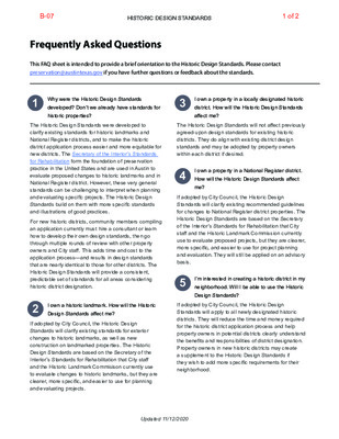
Frequently Asked Questions This FAQ sheet is intended to provide a brief orientation to the Historic Design Standards. Please contact preservation@austintexas.gov if you have further questions or feedback about the standards. 1 Why were the Historic Design Standards I own a property in a locally designated historic developed? Don’t we already have standards for district. How will the Historic Design Standards 3 historic properties? affect me? The Historic Design Standards were developed to clarify existing standards for historic landmarks and National Register districts, and to make the historic district application process easier and more equitable for new districts. The Secretary of the Interior’s Standards for Rehabilitation form the foundation of preservation practice in the United States and are used in Austin to evaluate proposed changes to historic landmarks and in National Register district. However, these very general standards can be challenging to interpret when planning and evaluating specific projects. The Historic Design Standards build on them with more specific standards and illustrations of good practices. For new historic districts, community members compiling an application currently must hire a consultant or learn how to develop their own design standards, then go through multiple rounds of review with other property owners and City staff. This adds time and cost to the application process—and results in design standards that are nearly identical to those for other districts. The Historic Design Standards will provide a consistent, predictable set of standards for all areas considering historic district designation. 2 I own a historic landmark. How will the Historic Design Standards affect me? If adopted by City Council, the Historic Design Standards will clarify existing standards for exterior changes to historic landmarks, as well as new construction on landmarked properties. The Historic Design Standards are based on the Secretary of the Interior’s Standards for Rehabilitation that City staff and the Historic Landmark Commisison currently use to evaluate changes to historic landmarks, but they are clearer, more specific, and easier to use for planning and evaluating projects. The Historic Design Standards will not affect previously agreed-upon design standards for existing historic districts. They do align with existing district design standards and may be adopted by property owners within each district if desired. 4 I own a property in a National Register district. How will the Historic Design Standards affect me? If adopted by City Council, the Historic Design Standards will clarify existing recommended guidelines for changes to …
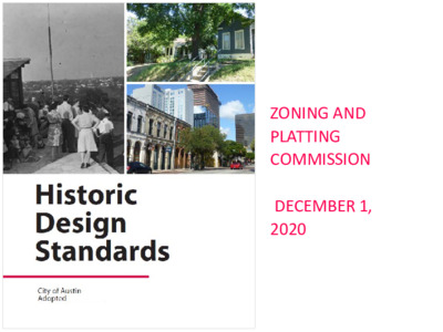
Historic Design Standards City of Austin Adopted _________ Welcome In Austin, historic preservation encourages the preservation of historic buildings, structures, sites, and districts; promotes awareness of cultural and architectural heritage; and helps shape a more sustainable, equitable, and livable place. As the city grows, these Historic Design Standards will help property owners, designers, builders, and historic preservation professionals make consistent decisions about how to meet present-day needs while stewarding local built heritage and achieving larger goals. Clear standards and graphics show good practices, as well as changes to avoid. The Historic Design Standards were created by a working group representing property owners, designers, developers, advocates, and the Historic Landmark Commission. The working group sought to develop locally relevant standards grounded in national preservation principles. Many members are laypeople, and readability was a key concern: the standards needed to be understandable by property owners and neighbors considering whether to apply for historic district designation, as well as by architects. A Maintenance and Preservation chapter and illustrated glossary support those who want to learn more about architectural elements and materials. The Historic Design Standards promote long-term sustainability by supporting the retention and repair of existing buildings, which keep tons of old-growth wood and other material in use and out of the landfill. They also support sustainable solutions for making buildings more energy efficient now, from high-impact improvements like attic insulation and duct sealing to DIY changes such as weather-stripping around windows and doors. Historic Preservation Office staff are available to answer questions and provide feedback on proposed projects. Reach out to preservation@austintexas.gov or call (512) 974-3393. Left cover image: People looking out over Austin, ca. 1940s Acknowledgments Design Standards Working Group The Historic Landmark Commission created the Design Standards Working Group on September 24, 2018 to create a new set of historic design standards, with the goals of providing clear, user-friendly standards and guidelines for all historic property owners and of simplifying the historic district application process. This document is the product of the working group’s efforts and is modeled on the Preservation Austin design standards template produced through a community initiative in April 2011. David Carroll, AIA Urban Design Commission, preservation architect Janet Beinke Historic district property owner Cara Bertron Historic Preservation Office staff Madeline Clites Preservation consultant Angela Gaudette Historic Preservation Office staff Laura Keating Urban Design staff Marie Oehlerking-Read Texas Historical Commission staff (prev.) Misael Ramos Representative from potential …
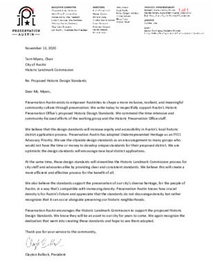
November 13, 2020 Terri Myers, Chair City of Austin Historic Landmark Commission Re: Proposed Historic Design Standards Dear Ms. Myers, Preservation Austin exists to empower Austinites to shape a more inclusive, resilient, and meaningful community culture through preservation. We write today to respectfully support Austin's Historic Preservation Office's proposed Historic Design Standards. We commend the time-intensive and community-focused efforts of the working group and the Historic Preservation Office staff. We believe that the design standards will increase equity and accessibility in Austin’s local historic district application process. Preservation Austin has adopted Underrepresented Heritage as an FY21 Advocacy Priority. We see the citywide design standards as an encouragement to many groups who would not have the time or money to develop unique standards for their proposed district. We are optimistic the design standards will encourage new local district applications. At the same time, these design standards will streamline the Historic Landmark Commission process for city staff and advocates alike by providing clear and consistent standards. We believe this will create a more efficient and effective process for the benefit of all. We also believe the standards support the preservation of our city's diverse heritage, for the people of Austin, in a way that's compatible with increasing density. Preservation Austin knows how crucial density is for Austin's future and appreciate that the standards do not discourage density but rather recognizes that it can occur alongside preserving our historic neighborhoods. Preservation Austin encourages the Historic Landmark Commission to support the proposed Historic Design Standards. We know they will be an asset to our city for years to come. We again recognize the dedication that went into creating these standards and hope to see them adopted. Thank you for your service to the community, Clayton Bullock, President 1 of 1B-16
ZONING AND PLATTING COMMISSION DECEMBER 1, 2020 Historic preservation is a tool to steward change. Historic preservation is a tool to steward change. Design standards provide a clear, objective way to evaluate proposed changes. WHY HISTORIC DESIGN STANDARDS? 1. 2. Increase equity by reducing resources required for the historic district application. Increase predictability for property owners in potential districts. 3. Take a common-sense approach to design standards by recognizing underlying principles. WHY HISTORIC DESIGN STANDARDS? 4. Provide clearer standards for historic landmark owners and National Register district property owners. 5. Provide an educational tool for all historic property owners. 6. Provide consistent standards for project review by commissioners and staff. 7. Follow good practices in preservation. SECRETARY’S STANDARDS FOR REHABILITATION 1. 2. 3. 4. 5. 6. 7. 8. 9. 10. A property will be used as it was historically or be given a new use that requires minimal change to its distinctive materials, features, spaces, and spatial relationships. The historic character of a property will be retained and preserved. The removal of distinctive materials or alteration of features, spaces, and spatial relationships that characterize a property will be avoided. Each property will be recognized as a physical record of its time, place, and use. Changes that create a false sense of historical development, such as adding conjectural features or elements from other historic properties, will not be undertaken. Changes to a property that have acquired historic significance in their own right will be retained and preserved. Distinctive materials, features, finishes, and construction techniques or examples of craftsmanship that characterize a property will be preserved. Deteriorated historic features will be repaired rather than replaced. Where the severity of deterioration requires replacement of a distinctive feature, the new feature will match the old in design, color, texture, and, where possible, materials. Replacement of missing features will be substantiated by documentary and physical evidence. Chemical or physical treatments, if appropriate, will be undertaken using the gentlest means possible. Treatments that cause damage to historic materials will not be used. Archeological resources will be protected and preserved in place. If such resources must be disturbed, mitigation measures will be undertaken. New additions, exterior alterations, or related new construction will not destroy historic materials, features, and spatial relationships that characterize the property. The new work will be differentiated from the old and will be compatible with the historic materials, features, size, scale and proportion, and …
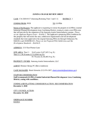
ZONING CHANGE REVIEW SHEET TO: LI-PDA CASE: C14-2020-0117 (Samsung Rezoning Tract 1 and 3-1) DISTRICT: 1 ZONING FROM: PUD Nature of the Request: The applicant is requesting to rezone the property to LI-PDA, Limited Industrial-Planned Development Area Combining District, zoning to create a new PDA area that will provide for the expansion of the Samsung Austin Semiconductor campus. Please see the Applicant Request Letter – Exhibit C. The applicant is proposing PDA conditions for this property that will mirror the uses, subdivision requirements and site development standards that were approved in the original Samsung PDA site through Ordinances No. 960229-L and 20190509-031. Please see the Proposed PDA Subdivision and Site Development Standards – Exhibit D. ADDRESS: 3215 East Parmer Lane SITE AREA: Tract 1: 56.42 acres (2,457,655.2 sq. ft.) Tract 3-1: 39.28 acres (1,711,036.8 sq. ft.) 95.70 acres (4,168,692.0 sq. ft.) PROPERTY OWNER: Samsung Austin Semiconductor, LLC AGENT: Drenner Group, PC (Dave Anderson) CASE MANAGER: Sherri Sirwaitis (512-974-3057, sherri.sirwaitis@austintexas.gov) STAFF RECOMMENDATION: Staff recommends LI-PDA, Limited Industrial-Planned Development Area Combining District, zoning with conditions. ZONING AND PLATTING COMMISSION ACTION / RECOMMENDATION: December 1, 2020 CITY COUNCIL ACTION: December 10, 2020 ORDINANCE NUMBER: ISSUES: C14-2020-0117 2 An amendment to the Pioneer Crossing Planned Unit Development (PUD) will be deferred. A condition of the approval for this case is a PUD amendment will be initiated to address the removal of this land area from the Pioneer Crossing PUD. CASE MANAGER COMMENTS: This property in question comprised of two undeveloped tracts of land located on the southeast corner of East Parmer Lane and Samsung Boulevard. This 95.98 acre site is to the east of the Samsung Semiconductor industrial campus across Samsung Boulevard. The original Samsung Austin Semiconductor plant is a 300-acre tract of land that fronts onto East Parmer Lane. The property was zoned LI-PDA in zoning case C14-96-0007 through Ordinance No. 960229-L. Surrounding land uses in the Pioneer Crossing Planned Unit Development (PUD) include undeveloped tracts of land directly to the north, south, east and west. There is a single-family residential neighborhood further to the south (Pioneer East). In this request, the applicant is requesting to remove land from the Pioneer Crossing PUD to rezone it to LI-PDA to create a new Planned Development Area (PDA) that will consistent with the zoning of the existing Samsung campus. The proposed PDA agreement will reflect almost the same conditions approved on the current Samsung Austin …
ZONING CHANGE REVIEW SHEET TO: LI-PDA CASE: C14-2020-0118 (Samsung Rezoning Tracts 2 and 3) DISTRICT: 1 ZONING FROM: PUD Nature of the Request: The applicant is requesting to rezone the property to LI-PDA, Limited Industrial-Planned Development Area Combining District, zoning to create a new PDA area that will provide for the expansion of the Samsung Austin Semiconductor campus. Please see the Applicant Request Letter – Exhibit C. The applicant is proposing PDA conditions for this property that will mirror the uses, subdivision requirements and site development standards that were approved in the original Samsung PDA site through Ordinances No. 960229-L and 20190509-031. Please see the Proposed PDA Subdivision and Site Development Standards – Exhibit D. ADDRESS: 2001 - 2821 East Parmer Lane and 11600 - 12161 Samsung Boulevard SITE AREA: Tract 2: 27.80 acres (1,210,968 sq. ft.) Tract 3: 81.45 acres (3,547,962 sq. ft.) 109.25 acres (4,758,930 sq. ft.) PROPERTY OWNER: Samsung Austin Semiconductor, LLC AGENT: Drenner Group, PC (Dave Anderson) CASE MANAGER: Sherri Sirwaitis (512-974-3057, sherri.sirwaitis@austintexas.gov) STAFF RECOMMENDATION: Staff recommends LI-PDA, Limited Industrial-Planned Development Area Combining District, zoning with conditions. ZONING AND PLATTING COMMISSION ACTION / RECOMMENDATION: December 1, 2020 CITY COUNCIL ACTION: December 10, 2020 ORDINANCE NUMBER: ISSUES: C14-2020-0118 2 An amendment to the Pioneer Crossing Planned Unit Development (PUD) will be deferred. A condition of the approval for this case is a PUD amendment will be initiated to address the removal of this land area from the Pioneer Crossing PUD. CASE MANAGER COMMENTS: The property in question is two undeveloped tracts of land, consisting of 109.237 acres, which abut the Samsung Semiconductor industrial campus to the west and south. The original Samsung Austin Semiconductor plant is a 300-acre tract of land that fronts onto East Parmer Lane. The property was zoned LI-PDA in zoning case C14-96-0007 through Ordinance No. 960229-L. Surrounding land uses in the Pioneer Crossing Planned Unit Development (PUD) include undeveloped tracts of land directly to the north, south, east and west. There are single-family residential neighborhoods further to the south (Pioneer East) and west (Pioneer Crossing West). In this request, the applicant is requesting to remove land from the Pioneer Crossing PUD to rezone it to LI-PDA to create a new Planned Development Area (PDA) that will consistent with the zoning of the existing Samsung campus. The proposed PDA agreement will reflect almost the same conditions approved on the current Samsung Austin Semiconductor site …
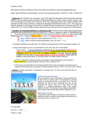
November 30, 2020 Memorandum for Zoning and Platting Commission Chair Kiolbassa and Members (Jolene.Kiolbassa@austintexas.gov) Subject: Against Staff Basis of Recommendation—No Bus for Samsung Rezoning (B-08: C14-2020-0117, B-09: C14-2020-0118) 1. Background: FM 734/Parmer Lane is car-centric. June 8, 2020 Capital Area Metropolitan Planning Organization reallocated $633M to I-35 Capital Express Central, eliminating 3 Northeast MetroRapid Lines (Parmer, Dessau, Decker)—funding, in part, Oak Hill (southwest least minorities) with no discourse. $7.1B Prop A disregarded 425-acre East Village development; 5,500 apartment units within 2 miles of Samsung—Imagine Austin Dessau/Parmer Neighborhood Center (p. A-31). “The county's most expensive agreement is with Samsung; Travis County has rebated $65 million in property taxes to Samsung since 2009,” KUT reported July 31, 2019. In light of $65M tax rebate, request Samsung provide Uber/Lyft cards to expand jobs to transit minorities. 2. Opposition - No Transit (Route 392/Dessau: 3-mile Samsung walk): “Staff recommends LI-PDA, Limited Industrial-Planned Development Area Combining District, zoning with conditions” (p. 2). However, I disagree with “BASIS OF RECOMMENDATION: 2. . . . The staff recommends the applicant’s request for LI-PDA zoning as the property is located on an arterial roadway, East Parmer Lane, which is a designated Activity Corridor as shown on the Imagine Austin Growth Concept Map” (p. 2). Backup - B-08 (C14-2020-0117 (Samsung Rezoning Tract 1).pdf (16.3MB) Backup - B-09 (C14-2020-0118 (Samsung Rezoning Tracts 2 and 3).pdf (15.3MB) a. Connectivity: Staff Report accurately notes, “The mobility and connectivity options in this area are below average” (p. 12). b. Imagine Austin (Adopted June 15, 2012; Amended 2013, 2014, 2015, 2016, 2017, 2018) definition: “Activity corridors . . . To improve mobility along an activity corridor, new and redevelopment should reduce per capita car use and increase walking, bicycling, and transit use. Intensity of land use should correspond to the availability of quality transit, public space, and walkable destinations. Site design should use building arrangement and open space to reduce walking distance to transit and destinations, achieve safety and comfort, and draw people outdoors” (p. 106). [Note: Unsafe = No sidewalk: Dessau to Samsung] LUT P20. Locate industry, warehousing, logistics, manufacturing, and other freight intensive uses in proximity to adequate transportation and utility infrastructure. (See also E P16) (p. 136/348) [p. 120] E P16. Expand connectivity within the Texas Triangle (Dallas/Fort Worth, Austin, San Antonio, and Houston) in order to facilitate movement of ideas, goods, and people for economic prosperity. (See also …
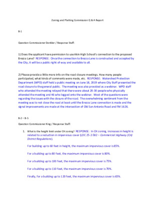
Zoning and Platting Commission Q & A Report B-1 Question Commissioner Denkler / Response Staff: 1) Does the applicant have permission to use Akin High School's connection to the proposed Brezza Lane? RESPONSE: Once the connection to Brezza Lane is constructed and accepted by the City, it will be a public right-of-way and available to all. 2) Please provide a little more info on the road closure meetings. How many people participated, what kinds of comments were made, etc. RESPONSE: Watershed Protection Department (WPD) staff held a public meeting on June 18, 2019 where City Staff presented the road closure to the general public. The meeting was also provided as a webinar. WPD staff who attended the meeting relayed that there were about 20-30 people who physically attended the meeting and 46 who logged onto the webinar. Most of the questions were regarding the issues with the closure of the road. The overwhelming sentiment from the meeting was to not close the road at least until the Brezza Lane connection is made and the signal improvements are made at the intersection of Old San Antonio Road and FM 1626. B-2 – B-5 Question Commissioner King / Response Staff: 1. What is the height limit under CH zoning? RESPONSE: In CH zoning, increases in height is related to a reduction in impervious cover (LDC 25-2-582 – Commercial Highway (CH) District Regulations). For building up to 60 feet in height, the maximum impervious cover is 85%. For a building up to 80 feet, the maximum impervious cover is 80%. For a building up to 100 feet, the maximum impervious cover is 75%. For a building up to 110 feet, the maximum impervious cover is 70%. Finally, for a building up to 120 feet, the maximum impervious cover is 65%. Note: Watershed regulations for impervious cover may be more restrictive than those cited above and would take precedence. The Gemini Tract sites are located in a Suburban watershed which limits impervious cover to 65% for commercial uses. 2. What hospital uses are allowed under CH zoning but not allowed under the current CS-MU zoning? RESPONSE: The hospital (general) use (includes overnight stays) is a conditional use in both CS and CH zoning. The hospital (limited) use is permitted in both the CH and CS-MU zoning districts. 3. As I understand, this site is exempt from transportation impact analysis (TIA). RESPONSE: Correct. If this …
Special Meeting of the Zoning and Platting Commission November 17, 2020 Zoning and Platting Commission to be held November 17, 2020 with Social Distancing Modifications Public comment will be allowed via telephone; no in-person input will be allowed. All speakers, including applicants and representatives, must register in advance (Day before the scheduled meeting, November 16, 2020 by noon. ) To speak remotely at the November 17, 2020 Zoning and Platting Commission Meeting, residents must: Preferably email Commission Liaison, Andrew Rivera at andrew.rivera@austintexas.gov or call 512-974-6508 (the day before the meeting). The following information is required: 1. The speaker name. 2. Item number(s) they wish to speak on. 3. Whether they are for/against/neutral. 4. Mailing address. 5. Telephone number. Must be the number that will be used to call-in. Failure to provide the required information by noon November 16 2020 shall render a request null and void. automatically roll over. A registered speaker may not sign up another speaker. Previous registration on an item does not •Once a request to register to speak has been called in or emailed to the board liaison, residents will receive either an email or phone call with additional information regarding the call in process. •Handouts or other information must be emailed to andrew.rivera@austintexas.gov by 1:00 PM Tuesday November 17 2020. This information will be provided to Commission members in advance of the meeting. •Residents may watch the meeting here: http://www.austintexas.gov/page/watch-atxn-live Time Allotment: Speakers: 3 minutes. Applicant: 6 minutes and 3 minutes rebuttal. Monday, November 16 2020 Postponement requests must be submitted to the case manager and Andrew Rivera by 5PM Reunión de la Comisión de Zoning and Platting Fecha 17 de Noviembre de 2020 La Comisión de Zoning and Platting se reunirá el 17 de Noviembre de 2020 con modificaciones de distanciamiento social. Se permitirán comentarios públicos por teléfono; no se permitirá ninguna entrada en persona. Llame o envíe un correo electrónico al enlace de la junta en 512-974-6508 andrew.rivera@austintexas.gov a más tardar al mediodía (el día antes de la reunion, 16 de Noviembre de 2020). 1. El nombre del orador. 2. Número (s) de artículo sobre el que desean hablar. 3. Si están a favor / en contra / neutrales. 4. Dirección postal. 5. Número de teléfono. Debe ser el número que se utilizará para llamar a la persona que desea hablar. Si la información solicitada no se envía antes del mediodía del 16 …
ZONING CHANGE REVIEW SHEET CASE: C14-2020-0116 – 10304 Old San Antonio Road ZONING FROM: I-RR ADDRESS: 10304 Old San Antonio Road TOTAL SITE AREA: 13.92 acres PROPERTY OWNERS: Bernadette M. Rainosek, Frank A. Miller, Walter John Miller AGENT: McLean & Howard, LLP (Jeffrey S. Howard) DISTRICT: 5 ZONING TO: MF-3 CASE MANAGER: Wendy Rhoades (512-974-7719, wendy.rhoades@austintexas.gov) STAFF RECOMMENDATION: The Staff recommendation is to grant multifamily residence – low density (MF-2) district zoning. For a summary of the basis of Staff’s recommendation, see case manager comments. ZONING AND PLATTING COMMISSION ACTION / RECOMMENDATION: November 17, 2020: CITY COUNCIL ACTION: December 10, 2020: ORDINANCE NUMBER: ISSUES: The Applicant is in agreement with the Staff recommendation. CASE MANAGER COMMENTS: The property is 13.92 acres and located on Old San Antonio Road, a two-lane roadway just west of IH-35 approximately one mile south of Slaughter Lane. For context, the Southpark Meadows development is further north (CS-CO). The property slopes gradually towards Slaughter Creek which generally follows the west property line, contains several groupings of trees and one single family residence. The property has been zoned interim – rural residence (I-RR) district since annexation into the City limits in 1997. Please refer to Exhibits A and A-1 – Zoning Map and Aerial Exhibit. The property is surrounded by an undeveloped tract and recently occupied Park and Recreation Department (PARD) offices to the north (GR-MU-CO; P; P-H); apartments and Akins High School football fields to the east (MF-2; MF-2-CO; I-RR); one single family 1 of 12B-1 C14-2020-0116 Page 2 residence and the Akins High School campus to the south (I-RR); and Slaughter Creek and apartments to the west (GR-MU-CO; MF-2-CO). The Applicant proposes to zone the property to the multi-family residence – medium density (MF-3) district so that it may be developed with approximately 197 apartment units. BASIS OF RECOMMENDATION: The proposed zoning should be consistent with the purpose statement of the district sought. Staff Recommendation: The multi-family residence low density (MF-2) district is intended to accommodate multifamily use with a maximum density of 23 units per acre, depending on unit size. This district is appropriate for multifamily residential areas located near single family neighborhoods or in an area for which low density multifamily use is desired. The Applicant is in agreement to the Staff recommendation. 1. 2. Zoning changes should promote compatibility with adjacent and nearby uses. 3. Zoning should be consistent with approved and …
ZONING CHANGE REVIEW SHEET CASE: C14-2020-0090 (Johnny Morris Road Rezoning) DISTRICT: 1 ZONING FROM: SF-2 TO: GR-MU* *Please see applicant’s request to amend the rezoning application to GR-MU-CO in the Issues section below and in Exhibit C. ADDRESS: 7008 Johnny Morris Road SITE AREA: 4.059 acres PROPERTY OWNER: Arabon Real Estate, LLC AGENT: Thrower Design LLC (A. Ron Thrower) CASE MANAGER: Sherri Sirwaitis (512-974-3057, sherri.sirwaitis@austintexas.gov) STAFF RECOMMENDATION: Staff recommends LO-MU, Limited Office-Mixed Use Combining District, zoning. ZONING AND PLATTING COMMISSION ACTION / RECOMMENDATION: November 17, 2020 CITY COUNCIL ACTION: ORDINANCE NUMBER: B-21 of 12 ISSUES: On November 11, 2020, the applicant sent an e-mail to the staff stating that they wanted to amend their rezoning request to GR-MU-CO (see Exhibit C). The applicant is proposing a conditional overlay to prohibit the following uses: • Automotive Rentals • Automotive Repair Services • Automotive Sales • Automotive Washing (of any type) • Exterminating Services • Pawn Shop Services • Drive-thru fast-food CASE MANAGER COMMENTS: The property in question is 4+ acre tract of land that is currently zoned SF-2 and developed with a single family residence fronting onto Johnny Morris Road. To the north, there is the Walnut Creek Greenbelt that is zoned P and lots that are developed with single-family residences zoned SF-4A. The lots to the east, across Johnny Morris Road, are also developed with single-family residential uses zoned SF-2. To the south, there is a developing multifamily use with amenities that was recently zoned GR-MU-CO through case C14-2018- 0117 – please see Area Case Histories below (Loyola Loft Apartments). The tract of land to the west contains a single-family home and undeveloped area. The applicant stated in their rezoning application that they are requesting GR-MU zoning to develop an office use at this location. The staff recommends LO-MU zoning for the site under consideration. The property meets the intent of the purpose statement for the Limited Office-Mixed Use Combining District as the LO district is intended for office and civic uses that serve neighborhood or community needs. The proposed MU combining district will permit any combination of office, retail, commercial, and residential uses within a single development. The proposed Limited Office-Mixed Use zoning will provide for a transition in the intensity of permitted uses/site development standards along Johnny Morris Road from the GR-MU- CO zoning at the arterial intersection of Loyola Lane and Johnny Morris Road to the SF-2 …
ZONING CHANGE REVIEW SHEET CASE: C14-2020-0111 (Vineyard Christian Fellowship of Austin, Texas, Inc.) DISTRICT: 6 ZONING FROM: I-RR ADDRESS: 13208 Morris Road SITE AREA: 8.47 acres (368,953.2 sq. ft.) PROPERTY OWNER: Vineyard Christian Fellowship of Austin, Texas, Inc. TO: Tract 1: MF-2 Tract 2: GR (Benjamin Koch) AGENT: Mathias Company (Richard Mathias) CASE MANAGER: Sherri Sirwaitis (512-974-3057, sherri.sirwaitis@austintexas.gov) STAFF RECOMMENDATION: Staff recommends MF-2, Multifamily Residence-Low Density District, zoning for Tract 1 and LO-MU, Limited Office-Mixed Use Combining District, zoning for Tract 2. ZONING AND PLATTING COMMISSION ACTION / RECOMMENDATION: November 17, 2020 CITY COUNCIL ACTION: ORDINANCE NUMBER: 1 of 18B-3 C14-2020-0111 ISSUES: 2 The applicant provided the following additional information regarding the property (Exhibit C): 1. This property was subdivided in 2008 (C8J-2008-0107.0A - please see Related Cases below) and dedicated nearly 17 feet of land area for the future expansion of Morris Road. This dedication was to accommodate a planned 70-foot ROW for Morris Road and included 35 feet from the existing centerline. 2. At the time of Plat, a sidewalk was required along the entire frontage of Morris Road. This sidewalk has been built and is existing. 3. At the time of Plat, the owner of the property posted fiscal for future improvements to Morris Road. 4. The Plat that was approved by the City of Austin restricts land uses to non-residential only. See plat note 22. The applicant will be re-subdividing this property and that note will be removed or amended to allow the multi-family portion to be developed. CASE MANAGER COMMENTS: The property in question consists of two tracts of land that front onto Morris Road. Tract 1 (4.91 acres) is an undeveloped area and Tract 2 (3.25 acres) is developed with a religious assembly use with associated parking. To the north of the property there is an Outdoor Sports and Recreation (Town & Country Sports - Miracle Field) that is does not have permanent zoning (I-RR). The lot to the south is zoned GR-CO and is developed with a commercial retail center. The properties to the east and west are developed with single family/duplex residential uses (I-SF-2). The staff recommends MF-2, Multifamily Residence-Low Density District, zoning for Tract 1 and LO-MU, Limited Office-Mixed Use Combining District, zoning for Tract 2. The property in question is located on Level 1, residential street and does not have frontage on Anderson Mill Road. Therefore, LO-MU zoning and MF-2 …
From: Marcia Spillers < > Sent: Thursday, November 12, 2020 9:33 PM To: Sirwaitis, Sherri <Sherri.Sirwaitis@austintexas.gov> Subject: Case Number C14‐2020‐0111 *** External Email - Exercise Caution *** Ms. Sirwaitis, I am writing to you to ask for a postponement of the hearing of Case Number C14-2020-0111 on November 17, 2020, by the Zoning and Platting Commission, until December 15, 2020, or later. With Covid 19 cases growing daily, our neighborhood has not had the opportunity to discuss with each other this rezoning and the impact it would have upon our single-family neighborhood. In the event of a possible lockdown, this would place any chance of discussion in the future, until Covid 19 has been contained. Furthermore, I would like to see the plans for the proposed rezoning for a daycare and apartment complex at the church, including the number of units, the parking layout, and a traffic impact study if there is one. Again, with the Covid 19 virus, this is most likely not doable until the virus has been contained. Last, with the runoff of candidates for City Council slated in December, I feel this issue should be heard after the first of the year, when the council members are in place and have the time to consider this fully. To do otherwise, would be imprudent to say the least. Thank you for taking the time to consider my request, and I look forward to hearing from you on this matter. Sincerely, Marcia Spillers 13210 Villa Park Drive Austin, Texas 78729 512-217-0989
ZONING CHANGE REVIEW SHEET TO: LI-PDA DISTRICT: 6 CASE: C14-2020-0006 (7700 Parmer Lane) ADDRESS: 7700 West Parmer Lane ZONING FROM: LI-PDA The requested PDA amendment is to allow a conversion of existing surface parking and provide additional uses on the property. This amendment request is to allow the following uses including a retail shopping center, hotel, restaurant and multifamily residential as permitted uses. ln addition, this amendment will allow the PDA to exceed the current maximum allowable square footage of 1,755,000 square feet with the inclusion of 80,000 square feet of a retail shopping center including restaurant uses, 340 rooms hotel rooms, and 1,800 multifamily residential units (Please see Applicant’s Request Letter – Exhibit C). SITE AREA: 128.847 acres PROPERTY OWNER: BRI 1869 Parmer, LLC AGENT: Drenner Group (Amanda Swor) CASE MANAGER: Sherri Sirwaitis (512-974-3057, sherri.sirwaitis@austintexas.gov) STAFF RECOMMENDATION: Staff’s recommendation is to grant LI-PDA, Limited Industrial-Planned Development Area, district zoning to amend the PDA zoning to allow for retail shopping center, hotel, restaurant and multifamily residential as permitted uses and to allow the PDA to exceed the current maximum allowable square footage of 1,755,000 square feet with the inclusion of 80,000 square feet of a retail shopping center including restaurant uses, 340 rooms hotel rooms, and 1,800 multifamily residential units. In addition, if the requested zoning is granted, site development should be limited to uses and intensities that will not exceed or vary from the projected traffic conditions assumed in the final TIA (Wantman Group, Inc – August 2020) through a public restrictive covenant that will be recorded prior to third reading of this case at City Council. The TIA recommendations are included as Exhibit D to this report. 1 of 24B-4 2 ZONING AND PLATTING COMMISSION ACTION / RECOMMENDATION: November 17, 2020 CITY COUNCIL ACTION: ORDINANCE NUMBER: 2 of 24B-4 3 ISSUES: N/A CASE MANAGER COMMENTS: The property in question is a 128.84 acre tract of land located on the southeast corner of West Parmer Lane/State Highway 734 and Anderson Mill Road. The site is currently developed with an industrial office campus which contains four large multi-story office buildings. This tract land is surrounded by undeveloped areas to the north, south, and east. There is a single- family residential neighborhood (Rattan Creek Neighborhood) to the west, across Parmer Lane. This site was granted PDA-ID, Planned Development Area and an Industrial District zoning in 1994, though Ordinance No. 940317-G. In …
SUBDIVISION REVIEW SHEET LOT(S): 384 COUNTY: Travis AGENT: Judd Willmann) ZAP DATE: November 17, 2020 JURISDICTION: Limited Purpose CASE NO.: C8J-2018-0151 SUBDIVISION NAME: Whisper Valley Village Phase 3 & Phase 4 AREA: 112.28 acres OWNER/APPLICANT: WVV1P3 & P4 LP ADDRESS OF SUBDIVISION: Braker and Petrichor Blvd. GRIDS: T-25 WATERSHED: Gilleland Creek EXISTING ZONING: Planned Unit Development (PUD) PROPOSED LAND USE: Residential- Single Family; park and landscape/sidewalk easement lots, and public ROW VARIANCES: None SIDEWALKS: Sidewalks will be provided along all internal streets and the boundary street. DEPARTMENT COMMENTS: The request is for the approval of the Whisper Valley Village Phase 3 and Phase 4 Preliminary Plan. The proposed preliminary plan is comprised of 384 lots on 112.28 acres, proposing 364 for private open space/drainage/joint use/pubic utility easement lots, and approximately 13,699 linear feet of right- of-way/streets. Sidewalks are proposed on all streets. The proposed lots comply with the PUD zoning requirements for use and lot size. Parkland is in compliance with the PUD. Water and wastewater will be provided by the City of Austin. STAFF RECOMMENDATION: Staff recommends approval of the final plat as it meets all applicable State, County and City of Austin LDC requirements. CASE MANAGER: Sue Welch, Travis County Single Office Email address: Sue.Welch@traviscountytx.gov PHONE: 512-854-7637 lots, and 20 other residential lots 1 of 2B-5 OLD HWY 20 D O R R B KIM D S R N O S R A P US HWY 290 B L A K E M A N O R R D VILLAGE 1 PHASE 1 3 7 9 M F B R A L A K E R N E PROJECT LOCATION A L C O N N D D E V GN N I S U L T 20 H 130 N S VILLAGE 1 PHASE 2 ELLS E C R N R L O L Y A T R O N A M D R E V E RLE Y R D VICINITY MAP CITY OF AUSTIN GRID: T-25 MAPSCO: 589(C), 589(D) 2 of 2B-5
SUBDIVISION REVIEW SHEET CASE NO.: C8-89-0104.0A(VAC) ZAP DATE: November 17, 2020 SUBDIVISION NAME: Total vacation of the Amended plat of Lots 30 & 31, Block D Manor Road Addition. AREA: 0.48 acre (21,120 sf) LOTS: 1 APPLICANT: Cambridge Court, LLC AGENT: Beth Turner (Thrower Design, LLC) ADDRESS OF SUBDIVISION: 3403 Cambridge Court GRIDS: ML23 COUNTY: Travis WATERSHED: Tannehill Branch JURISDICTION: Full Purpose EXISTING ZONING: SF-3 DISTRICT: 1 LAND USE: Residential DEPARTMENT COMMENTS: The request is for the approval of the total vacation of the Amended plat of Lots 30 & 31, Block D Manor Road Addition. Currently, there is one lot containing 21,120 sf. When the plat is vacated, the property will be comprised of two lots, because the underlying plat will control. The size of the entire property will not change. After the vacation, there will be two lots: Lot 30, containing 8,643 sf and Lot 31, containing 12,477 sf. These lots comply with zoning requirements for use, lot width and lot size. STAFF RECOMMENDATION: The staff recommends approval of the plat. The plat vacation meets all applicable State and City of Austin Land Development Code requirements. ZONING AND PLATTING COMMISSION ACTION: CASE MANAGER: Steve Hopkins PHONE: 512-974-3175 E-mail: steve.hopkins@austintexas.gov ATTACHEMENTS Exhibit A: Vicinity map Exhibit B: Plat vacation document Exhibit C: existing plat to be vacated Exhibit D: underlying plat 1 of 6B-6 Legend Street Labels Jurisdiction FULL PURPOSE LIMITED PURPOSE EXTRATERRITORIAL JURISDICTION 2 MILE ETJ AGRICULTURAL AGREEMENT OTHER CITY LIMITS OTHER CITIES ETJ 0.2 0 0.08 0.2 Miles NAD_1983_StatePlane_Texas_Central_FIPS_4203_Feet Date Printed: This product is for informational purposes and may not have been prepared for or be suitable for legal, engineering, or surveying purposes. It does not represent an on-the-ground survey. This product has been produced by the City of Austin for the sole purpose of geographic reference. No warranty is made by the City of Austin regarding specific accuracy or completeness. 1: 4,800 Notes 2 of 6B-6 TOTAL VACATION OF AMENDED PLAT OF LOTS 30 & 31, BLOCK D, MANOR ROAD ADDITION LOT All lots OWNER Cambridge Court Austin LLC THE STATE OF TEXAS COUNTY OF TRAVIS Whereas Albert J. Walker, owner of 0.48 acres, did heretofore subdivide the same into the subdivision designated AMENDED PLAT OF LOTS 30 & 31, BLOCK D, MANOR ROAD ADDITION, the plat of which is recorded in Book 88, Page 344 of the Travis County, Texas Official Public Records, and WHEREAS, …