20220706-002: C814-09-0139.03 Bull Creek PUD Amendment Zoning Packet 2 of 2 — original pdf
Backup
Backup
Play video
1 ENVIRONMENTAL COMMISSION MOTION 20220706-003 Date: July 6, 2022 Subject: Mercedes Benz South Austin (SP-2021-0127C) Motion by: Jennifer L. Bristol RATIONALE: Seconded by: Pam Thompson WHEREAS, the Environmental Commission recognizes the applicant is requesting a variance from LDC 25- 8-261 to allow a private driveway access point to the site through a Critical Water Quality Zone buffer. WHEREAS, the Environmental Commission recognizes the site is located in the Onion Creek, Suburban Watershed, and the Desired Development Zone; and WHEREAS, the Environmental Commission recognizes having determined the required Findings of Fact have been met that Staff recommends this variance with the following conditions. THEREFORE, the Environmental Commission recommends the variance request with the following: Staff Conditions: 1. Increase Critical Water Quality Zone buffer averaged area to enhance overall preservation. 2. Revegetate throughout the entire Critical Water Quality Zone within the property thus maintaining the existing channel. 3. Add tree plantings in the vehicle storage lot islands. and the following Environmental Commission Conditions: 1. VOTE 9-0 Include water quality measures, including a raingarden and water quality pond. For: Bedford, Qureshi, Schott, Thompson, Barrett Bixler, Nickells, Bristol, Aguirre, and Brimer Against: None Abstain: None Recuse: None Absent: Schiera and Ramberg Approved By: Perry Bedford, Environmental Commission Vice Chair 2
Regular Meeting of the Environmental Commission June 15, 2022 at 6:00 P.M. Permitting and Development Center, Events Center, Room 1406 6310 Wilhelmina Delco Drive, Austin, Texas 78752 Some members of the Environmental Commission will be participating by videoconference. The meeting may be viewed online at: http://www.austintexas.gov/page/watch-atxn-live Public comment will be allowed in-person or remotely by telephone. Speakers may only register to speak on an item once either in-person or remotely and will be allowed up to three minutes to provide their comments. Registration no later than noon the day before the meeting is required for remote participation. To register to speak remotely, call or email the Jackie Ramos, Watershed Protection Department, at (512) 964-9366, Jacqueline.Ramos@austintexas.gov, no later than noon, (the day before the meeting). The following information is required: speaker name, item number(s) they wish to speak on, whether they are for/against/neutral, email address and telephone number (must be the same number that will be used to call into the meeting). COMMISSIONERS: Haris Qureshi (D-1) Rachel Scott (D-2) Pam Thompson (D-3) Melinda Schiera (D-4) Kevin Ramberg (D-8) Chair Audrey Barrett Bixler (D-5) Ana Aguirre (D-9) Colin Nickells (D-6) Richard Brimer (D-10) Jennifer Bristol (D-7) Secretary Perry Bedford (Mayor) Vice-Chair _________________________________________________________________________________ Agenda CALL TO ORDER PUBLIC COMMUNICATION: GENERAL The first 10 speakers who register to speak no later than noon the day before the meeting will be allowed a three-minute allotment to address their concerns regarding items not posted on the agenda. 1 1. 2. 3. APPROVAL OF MINUTES AND ACTION a. Approval of the June 1, 2022 Environmental Commission Regular Meeting Minutes (5 minutes) STAFF BRIEFINGS a. Update on Austin’s reservoirs monitoring and management efforts—Brent Bellinger, Environmental Scientist, Watershed Protection Department (30 minutes) b. Update on resolution relating to environmental protections and water quality; and initiating amendments to the City Code—Liz Johnston, Deputy Environmental Officer, Watershed Protection Department (30 minutes) COMMITTEE REPORTS a. Urban Forestry Committee – Richard Brimer (Committee Chair), Pam Thompson, b. Report on the Joint Sustainability Committee – Haris Qureshi (member) and Richard Rachel Scott, and Colin Nickells Brimer (alternate member) Committee – Jennifer Bristol c. Report on the Balcones Canyonlands Conservation Plan Citizen’s Advisory d. Report on the Joint Committee of the Environmental Commission and Parks and Recreation Board –Pam Thompson, Rachel Scott, Perry Bedford, and Haris Qureshi e. Report on the South Central Waterfront Advisory Board – Ana Aguirre FUTURE AGENDA ITEMS 5. ADJOURNMENT The …
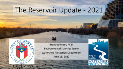
The Reservoir Update - 2021 Brent Bellinger, Ph.D. Environmental Scientist Senior Watershed Protection Department June 15, 2022 2021/2022 Projects • On-going Projects • Reservoir monitoring – Austin Lakes Index (ALI) of Lake Austin, Lady Bird Lake, Lake Walter Long • Lake Austin native plant restoration • Collaboration with TPWD fishery monitoring • Zebra Mussel monitoring • Harmful Algal Proliferation (HAP) monitoring • With added sites • New Projects mitigation • Lady Bird nutrient management toward HAP • Collaboration with UT toward sediment bedform mapping and microplastic observations Austin Lakes Index (ALI) Current reservoir condition • Water quality, sediments, aquatic vegetation generally above average • Benthic invertebrates, habitat, eutrophication generally below average ReservoirLake AustinLady Bird LakeWalter E. Long LakeScore020406080100Water qualityBenthic invertebratesAquatic vegetationSediment chemistryHabitat structureEutrophicationOverall scoreExcellentVery goodGoodMarginalPoorBadFair Temporal Trends • Although overall scores appear steady, sub-index components can have large variability Year2010201220142016201820202022Overall lakes Index020406080100Lake AustinLady Bird LakeWalter E. Long LakeExcellentVery goodVery badBadPoorMarginalFairGood2010201220142016201820202022Water quality index405060708090Year2010201220142016201820202022Invertebrate index304050607080 Re-vegetation Efforts • Macrophytes doing well in cages in both reservoirs, thriving outside of cages in LBL • Maintained existing pens in both reservoirs, added new pens to Lake Austin Zebra Mussel Populations • “Ecosystem engineers” that have altered water quality, alter food webs • For example, water clarity correlated with densities L. Austin Flow LBL Year2018201920202021#/m210100100010000Lake AustinLady BirdBig Horn Dr.Kollmeyer Dr.Oppo. CommmonsOppo. Emma LongOpp. MananaRivercrestNalleHoldsworthWalsh#/m21101001000100002018 2019 2020 2021 Red Bud WestMoPac CageRailroad BridgeBoardwalk u. I-35Snake IslandHolly Peninsula#/m2110100100010000 Harmful Algal Proliferations (HAPs) Jessica Hollis Park – 3 positives Emma Long – 0 positives Jessica Hollis Park = 0.06 ± 0.03 mg ATX/kg Walsh Ramp = 1.56 ± 3.03 mg ATX/kg Red Bud – 9 positives Walsh Ramp – 3 positives Red Bud = 0.11 ± 0.13 mg ATX/kg Aud. shores = 0.007 ± 0.013 mg ATX/kg Festival Ramp = 0.002 ± 0.004 mg ATX/kg 19.68 ± 34.53 mg CYN/kg Auditorium Shores – 3 positives Festival Beach – 3 positives Nutrient Mitigation Pilot Project • Background: We are limited in the environmental drivers of HAPs that can be effectively managed • One of the most important drivers is Phosphorus (P) • Hypothesis being tested: Reducing available sediment P will negatively impact HAP growth and toxicity • Sediments of Lady Bird Lake are very P-rich Phoslock • Toward that end, we secured a multi-year contract with SePRO to apply lanthanum- modified bentonite toward sediment P management • Phoslock utilized globally to mitigate excess P that may be released from …
Motion Sheet CM Kelly June 9th, 2022 Item 61 I motion to add the following to line 120: BE IT FURTHER RESOLVED: The City Manager is directed to come back with recommendations and considerations in the form of a memorandum of required city staff hours to initiate the completion of this resolution by September 1st, 2022.
6/9 Item 61 Water Quality CM Vela Amendment 1 - V4 Proportionate Standards for Missing Middle Housing Add the following WHEREAS: WHEREAS, small scale missing middle housing projects (projects with approximately 3 to 12 units) are required to comply with the same procedures and requirements for review of water quality protections and site plans as large scale multifamily residential projects, while single family homes are not subject to those requirements, creating an incentive for developers to build single family homes over missing middle housing to avoid water quality regulations, contributing to suburban sprawl and the housing affordability crisis. Insert the following language after line 153: The City Council directs the City Manager to account for differences in the additional cost of compliance resulting from these code amendments between single family homes, small scale missing middle projects and larger multifamily projects, so that such costs are proportionate to the scale of the project, and do not disincentivize the construction of small scale missing middle projects in favor of single family homes. Add the following BE IT FURTHER RESOLVED: BE IT FURTHER RESOLVED: The City Council initiates City Code amendments and directs the City Manager to provide recommendations for changes to the City Code to ensure that the cost of compliance with water quality, drainage, and Site Plan requirements relating to single family homes and small scale missing middle projects is proportionate to the scale of the project, and does not disincentivize the construction of small scale missing middle projects in favor of single family homes, including applying some water quality and drainage requirements to single-family development as proposed during the LDC Revision.
6/9 Item 61 Water Quality CM Vela Amendment 1 - V4 to V5 Additions Bolded Proportionate Standards for Missing Middle Housing Add the following WHEREASes: WHEREAS, small scale missing middle housing projects (projects with approximately 3 to 12 units) are required to comply with the same procedures and requirements for review of water quality protections and site plans as large scale multifamily residential projects, while single family homes are not subject to those requirements, creating an incentive for developers to build single family homes over missing middle housing to avoid water quality regulations, contributing to suburban sprawl and the housing affordability crisis; WHEREAS, a large single family home can actually have more impervious cover than a multi-unit development, and the amount of impervious cover for a project is one of the key factors affecting drainage regardless of project type and should be taken into account when evaluating water quality and drainage requirements for site plans; Insert the following language after line 153: The City Council directs the City Manager to account for differences in the additional cost of compliance resulting from these code amendments between single family homes, small scale missing middle projects and larger multifamily projects, so that such costs are proportionate to the scale of the project and the amount of impervious cover, and do not disincentivize the construction of small scale missing middle projects in favor of single family homes. Add the following BE IT FURTHER RESOLVED: BE IT FURTHER RESOLVED: The City Council initiates City Code amendments and directs the City Manager to provide recommendations for changes to the City Code to ensure that the cost of compliance with water quality, drainage, and Site Plan requirements is proportionate to the amount of impervious cover for a project, and does not disincentivize the construction of small scale missing middle projects in favor of single family homes, including applying some water quality and drainage requirements to single-family development as proposed during the LDC Revision.
1 2 3 4 5 6 7 8 9 10 11 12 13 14 15 16 17 18 19 20 21 22 23 RESOLUTION NO. WHEREAS, protecting our environment is the foundation for sustaining our planet, community, and economy; and WHEREAS, the City of Austin’s “State of Our Environment: 2020 Annual Report,” showed that creeks in the Desired Development Zone scored on average 10 points lower than those in the Drinking Water Protection Zone; and WHEREAS, the Drinking Water Protection Zone designation located on the west side of Austin has restricted development through regulations creating positive environmental outcomes, while the Desired Development Zone, located in Central and East Austin, has more permissive regulations that have resulted in some negative outcomes; and WHEREAS, properties located in the Desired Development Zone have more permissive development regulations with regard to the size of creek buffers, impervious cover limits, cut and fill, and construction on slopes; and WHEREAS, extensive empirical literature links exposure to nature with better health, and creeks provide city-wide opportunities to experience nature; and WHEREAS, current code allows for structures such as in-channel detention basins and concrete wastewater manholes to be placed in creeks, which can cause erosion and other severe, often long-lasting consequences that can be expensive to reverse; and WHEREAS, the City is faced with the existing and growing threat of industrial discharges that can negatively impact creeks and communities located primarily on the east side of the City of Austin; and Page 1 of 8 24 25 26 27 28 29 30 31 32 33 34 35 36 37 38 39 40 41 42 43 44 45 46 47 WHEREAS, there has been a steady increase in the amount of land area in Austin covered by impervious surfaces and a corresponding steady decrease in the amount of pervious land area capable of absorbing rainfall; and WHEREAS, one result of the historically high rates of development is a rise in the amount of runoff that flows off-site from developed properties and into older, undersized stormwater drain systems, creeks, rivers, and lakes, contributing to increases in flooding severity, damage to private property, loss of life, and water pollution; and WHEREAS, currently City Code allows redeveloped sites to use existing impervious cover as a baseline for drainage calculations, resulting in increased runoff and contributing to flooding and erosive flows downstream; and WHEREAS, a U.S. Geological Survey study found that using green …
June 9, 2022 Item 61 Mayor Adler CM Harper-Madison CM Ellis MOTION SHEET I move to amend Item 61 as follows: Insert at Line 35: WHEREAS, increasing density reduces sprawl and thereby reduces traffic congestion, pollution, and development of open spaces and agricultural land; and The City Council initiates other code amendments, as necessary, to Insert at Line 150: accomplish the goals of this Resolution. Beginning at Line 154: The City Manager shall present these code amendments for Council consideration no later than September 15, 2022, except for amendments regarding the greenfield conditions as a baseline for redevelopments and steep slope protections. The City Council directs the City Manager to engage stakeholders and develop recommendations that would seek to offset the impact on affordability and capacity of requiring greenfield conditions as a baseline and steep slope protections on properties where they are not currently required. Offsets could include additional entitlements or waivers for impacted tracts. The City Manager shall present these recommended code amendments for Council consideration no later than December 8, 2022.
June 9, 2022 Item 61 Motion Sheet CM Renteria Amend the Be It Resolved clause beginning at line 163 to read: BE IT FURTHER RESOLVED: The City Council directs the City Manager to conduct an Affordability Impact Analysis and a Fiscal Impact Analysis for each proposed code or process change resulting from this resolution. The City Council directs the City Manager to provide the results of these analyses to Council at least two weeks prior to the implementation of any process change or the presentation of proposed code amendments for Council consideration. The City Council directs the City Manager to include these analyses as part of the Council agenda back up when an item resulting from this resolution is presented to Council for its consideration. Additionally, the City Council directs the City Manager to address the estimated costs of doing nothing to further protect against water pollution, localized flooding, and the heat island effect; of stabilizing creeks and shorelines after scouring and erosive floods; mitigating algae and bacteria in creeks and lakes; and increasing stormwater infrastructure throughout the City.
2022 Environmental Code Amendments Briefing to the Environmental Commission J u n e 1 5 , 2 0 2 2 C I T Y O F A U S T I N W A T E R S H E D P R O T E C T I O N D E P A R T M E N T Council Resolution #20220609-061 D i r e c t s C i t y M a n a g e r t o a c t o n e nv i ro n m e n t a l a n d d r a i n a g e c o n c e r n s a n d eva l u a t e i m p a c t s o f p ro p o s e d p ro c e s s a n d c o d e c h a n g e s o n a f f o r d a b i l i t y, h o u s i n g, a n d c o s t • • • Bring forth a plan to address environmental equity Increase monitoring of high risk/industrial sites Process improvements to better address high bacteria levels in creeks related to leaky wastewater infrastructure Bring forth code amendments related to environmental protection and flood reduction: • Subset of code changes identified by previous Land Development Code revision process • • Minor revisions and inconsistencies • • Improve protections for Colorado River downstream of the Longhorn Dam Evaluate impacts to housing C I T Y O F A U S T I N W A T E R S H E D P R O T E C T I O N D E P A R T M E N T 2 Affected Land Development Code (LDC) Chapters L D C C h a p t e r 2 5- 2 ( Z o n i n g ) • Landscape requirements (Functional Green) • DSD is lead department L D C 2 5- 7 ( D r a i n a g e ) • No adverse impact (greenfield detention requirements) 2 5- 8 S u b c h a p t e r A ( Wa t e r Q u a l i t y ) …
Play video
Regular Meeting of the Environmental Commission June 1, 2022 at 6:00 P.M. Permitting and Development Center, Events Center, Room 1405 6310 Wilhelmina Delco Drive, Austin, Texas 78752 Some members of the Environmental Commission will be participating by videoconference. The meeting may be viewed online at: http://www.austintexas.gov/page/watch-atxn-live Public comment will be allowed in-person or remotely by telephone. Speakers may only register to speak on an item once either in-person or remotely and will be allowed up to three minutes to provide their comments. Registration no later than noon the day before the meeting is required for remote participation. To register to speak remotely, call or email the board liaison Kaela Champlin, (512) 974-3443, Kaela.Champlin@austintexas.gov, no later than noon, (the day before the meeting). The following information is required: speaker name, item number(s) they wish to speak on, whether they are for/against/neutral, email address and telephone number (must be the same number that will be used to call into the meeting). COMMISSIONERS: Haris Qureshi (D-1) Rachel Scott (D-2) Pam Thompson (D-3) Melinda Schiera (D-4) Kevin Ramberg (D-8) Chair Audrey Barrett Bixler (D-5) Ana Aguirre (D-9) Colin Nickells (D-6) Richard Brimer (D-10) Jennifer Bristol (D-7) Secretary Perry Bedford (Mayor) Vice-Chair _________________________________________________________________________________ Agenda CALL TO ORDER PUBLIC COMMUNICATION: GENERAL The first 10 speakers who register to speak no later than noon the day before the meeting will be allowed a three-minute allotment to address their concerns regarding items not posted on the agenda. 1 1. 2. 3. APPROVAL OF MINUTES AND ACTION a. Approval of the May 18, 2022 Environmental Commission Regular Meeting Minutes (5 minutes) ITEMS FOR CONSIDERATION AND POSSIBLE ACTION a. Briefing on the 517 Lamar PUD Development Assessment—Heather Chaffin, Housing and Planning Department (30 minutes) PUBLIC HEARINGS a. Consider a proposed annexation of approximately 5.03 acres into Travis County Water Control and Improvement District No. 10, C12M-2022-0001—Andrei Lubomudrov, Housing and Planning Department (30 minutes) b. Name: Sky Mountain, SP-2021-0079C Applicant: Reese Hurley, LJA Engineering, Inc. Location: 8722 W SH 71, Austin, TX 78735 Council District: District 8 Staff: Pamela Abee-Taulli, Environmental Program Coordinator, Development Services Department and Miranda Reinhard, Watershed Protection Department Watershed: Williamson Creek, Barton Springs Zone, Drinking Water Protection Zone Requests: Request to vary from LDC 25-8-341to allow cut over 4 feet to 16 feet. Staff Recommendation: Recommended with conditions (15 minutes) c. Name: 8020 Parmer Lane SH 130 NW, C8J-2021-0141.0A Applicant: Pape-Dawson Engineers, Travis Moltz Location: 8106 E …
BRIEFING SUMMARY SHEET DEVELOPMENT ASSESSMENT CASE NUMBER: CD-2022-0001 REQUEST: Presentation of a Development Assessment report for the 517 South Lamar Planned Unit Development (PUD) located at 517 South Lamar Boulevard. The property is located southeast of the intersection of Barton Springs Road and South Lamar Boulevard in the West Bouldin Creek Watershed. DISTRICT: 5 DEPARTMENT COMMENTS: The applicant proposes to rezone a 1.87 acre property from General Commercial Services-Vertical Mixed Use (CS-V) to Planned Unit Development (PUD) zoning. The property is currently developed with commercial land uses including limited retail and medical services. The applicant proposes the property be redeveloped with a 9- story building with approximately 400 multifamily residential units above approximately 10,000 square feet of ground floor mixed commercial land use and underground parking. The proposed rezoning would use CS-V as its base zoning district, with some modifications via the PUD rezoning. The applicant has stated that the project will comply with all Tier One PUD development standards, as well as several Tier Two standards. Tier Two standards proposed include: providing a minimum of 10% of multifamily units for families earning less than 60% of the annual Median Family Income (MFI), placing 95% of parking in a subsurface parking garage, reducing impervious cover, burying overhead utilities along Lamar Boulevard, improving local drainage conditions, utilizing green water quality controls, improved landscaping standards, rainwater irrigation, achieving a 3-star Green Building rating, increased bicycle parking, and other improvements. The applicant proposes the following Code modifications: allow the optional supplemental zone between the building and clear zone to increase from a maximum of 30 feet to 68 feet; allow a building height of 102 feet; waive Compatibility Standards as related to building height; modify scale and clustering requirements; and allow PUD zoning on a site less than 10 acres. OWNERS: Adelaide Murphey and Jack S. Gray APPLICANT: Armbrust & Brown, PLLC (Richard Suttle) ENVIRONMENTAL COMMISSION BRIEFING DATE: June 1, 2022 CITY COUNCIL BRIEFING DATE: June 14, 2022 ASSIGNED STAFF: Heather Chaffin ATTACHMENTS: EXHIBIT A: Zoning map EXHIBIT B: Aerial Exhibit EXHIBIT C: Proposed Land Use Plan EXHIBIT D: Requested variance table EXHIBIT E: Proposed Tier 1 and Tier 2 superiority table Email: heather.chaffin@austintexas.gov Phone: 512-974-2122 P T O O M E Y R D CS-1 CS PUD P W RIVERSIDE DR P-NP CS MF-6-CO CS SF-3 SF-3-H N L N M E G H A SF-3 VIR GINIA A V E SF-3 …
MEMORANDUM TO: Chair and Members of the Environmental Commission FROM: Andrei Lubomudrov Housing and Planning Department DATE: May 25, 2022 RE: Proposed annexation of one property (approximately 5.03 acres) into Travis County Water Control and Improvement District No. 10 (District); case: C12M-2022-0001 On April 13, 2022, the City received an application requesting the City’s consent to the annexation of approximately 5.03 acres located at 4315 Dunning Lane in Austin’s extraterritorial jurisdiction (ETJ) and in the Lake Austin Watershed. The District includes properties in western Travis County and located either in the City of Austin’s ETJ or the City of West Lake Hills. The property to be annexed into the District is located in the Lake Austin Watershed. A map identifying the tract to be annexed into the District and its location relative to existing District boundaries and City jurisdictions is attached. Applicant’s Proposal The applicant seeks annexation into WCID 10 to acquire water service for about half of an existing 10-acre property, or approximately 5.03 acres. If annexation approval is granted, the property owner will subdivide the existing 10-acre property and seek to serve the 5-acre portion of the replatted lot through WCID 10. The balance of the property will be in Austin Water’s service area. As part of the Annexation into a Water District process, case number C12M-2022-0001 will go before Austin’s Commissions as well as Austin City Council. Upon City Council approval, the property will then be annexed by the District. Representatives of the property owners appeared before the District’s Board of Directors at its meeting on January 12, 2022, and the District Board approved the annexation request contingent upon receiving the City’s approval of the District’s annexation of the property. 1 City Review Process The Agreement Concerning Creation of the Travis County Water Control and Improvement District No. 10 (Consent Agreement) requires City approval for the annexation of land by the District. The District is considered a “noncity service district” and as such, the City is not authorized to place restrictions or conditions on this consent. If the City fails or refuses to consent within 90 days of receipt of a written request, the owner may petition the City to make available those services to be provided by the District. Failure to execute a mutually agreeable contract for services within 120 days constitutes authorization for inclusion of land within the District. Requests for annexation into a water …

Proposed Annexation into Travis County Water Control and Improvement District No. 10 Environmental Commission June 1, 2022 Consider a request for City consent to annexation of one property totaling 5.03 acres into Travis County Water Control and Improvement District No. 10 (District) Overview City Review Process Applicant’s Proposal Staff Recommendation The Environmental Commission is asked to make a recommendation on the request for City consent to the proposed annexation 2 City Review Process City Code requires staff and commission review prior to Council action Evaluation in terms of: Impact on the City’s annexation program Land Use impacts Austin Water’s ability to provide direct water service Terms of City contracts with the District Environmental impacts Whether the annexation would induce development within the Drinking Water Protection Zone (DWPZ) beyond what would occur otherwise 3 Applicant’s Proposal Owner is requesting annexation into the District which will allow the District to provide water service The District Board has approved the annexation request contingent upon receiving the City’s approval Proposed annexation is partially within WCID 10 currently Annexation would allow subdivision to formally separate large and small lot configuration into two similar-sized lots 4 Subject Tract Approximately 5.03 acres, currently undeveloped Located at 4315 Dunning Lane; west of the intersection of Westlake Dr and Dunning Lane; just east of the border of Lake Austin and Bee Creek watersheds Lake Austin Watershed 5 Subject Tract 6 7 8 9 Basis for Staff Recommendation property Annexation of this tract into the District will not affect Austin’s annexation plans and staff does not anticipate any negative land use impacts on adjacent property Austin Water would not otherwise provide service to the Regulations for development will follow the same rules and processes currently in effect if the District annexes the tract 10 Staff and Commission Recommendation Staff recommends consent to the annexation into the Travis County Water Control and Improvement District No. 10 The Environmental Commission is asked to make a recommendation on the request for City consent to the proposed annexation 11
Proposed Annexation into Travis County Water Control and Improvement District No. 10 Environmental Commission June 1, 2022 Consider a request for City consent to annexation of one property totaling 5.03 acres into Travis County Water Control and Improvement District No. 10 (District) Overview City Review Process Applicant’s Proposal Staff Recommendation The Environmental Commission is asked to make a recommendation on the request for City consent to the proposed annexation 2 City Review Process City Code requires staff and commission review prior to Council action Evaluation in terms of: Impact on the City’s annexation program Land Use impacts Austin Water’s ability to provide direct water service Terms of City contracts with the District Environmental impacts Whether the annexation would induce development within the Drinking Water Protection Zone (DWPZ) beyond what would occur otherwise 3 Applicant’s Proposal Owner is requesting annexation into the District which will allow the District to provide water service The District Board has approved the annexation request contingent upon receiving the City’s approval Proposed annexation is partially within WCID 10 currently Annexation would allow subdivision to formally separate large and small lot configuration into two similar-sized lots 4 Subject Tract Approximately 5.03 acres, currently undeveloped Located at 4315 Dunning Lane; west of the intersection of Westlake Dr and Dunning Lane; just east of the border of Lake Austin and Bee Creek watersheds Lake Austin Watershed 5 Subject Tract 6 7 8 9 Basis for Staff Recommendation property Annexation of this tract into the District will not affect Austin’s annexation plans and staff does not anticipate any negative land use impacts on adjacent property Austin Water would not otherwise provide service to the Regulations for development will follow the same rules and processes currently in effect if the District annexes the tract 10 Staff and Commission Recommendation Staff recommends consent to the annexation into the Travis County Water Control and Improvement District No. 10 The Environmental Commission is asked to make a recommendation on the request for City consent to the proposed annexation 11
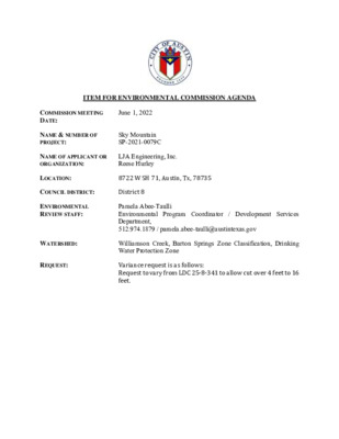
ITEM FOR ENVIRONMENTAL COMMISSION AGENDA COMMISSION MEETING DATE: June 1, 2022 NAME & NUMBER OF PROJECT: Sky Mountain SP-2021-0079C NAME OF APPLICANT OR ORGANIZATION: LJA Engineering, Inc. Reese Hurley LOCATION: 8722 W SH 71, Austin, Tx, 78735 COUNCIL DISTRICT: District 8 ENVIRONMENTAL REVIEW STAFF: WATERSHED: REQUEST: Pamela Abee-Taulli Environmental Program Coordinator / Development Services Department, 512.974.1879 / pamela.abee-taulli@austintexas.gov Williamson Creek, Barton Springs Zone Classification, Drinking Water Protection Zone Variance request is as follows: Request to vary from LDC 25-8-341 to allow cut over 4 feet to 16 feet. STAFF RECOMMENDATION: Staff recommends this variance, having determined the findings of fact to have been met. STAFF CONDITION: Staff recommends the following conditions: 1. All grading over 8 feet will be contained with terracing or engineered walls. 2. Around the perimeter of the limits of construction, and in areas where more than 3’ of vertical rise is proposed, 3:1 slopes will have erosion control matting applied immediately after final grade is achieved. 3. Disturbance in the stormwater irrigation fields will be minimized by restricting the LOC and routing the irrigation lines to preserve existing trees to the greatest extent possible. Page 2 of 2 Development Services Department Staff Recommendations Concerning Required Findings Project Name: Ordinance Standard: Watershed Protection Ordinance Variance Request: Sky Mountain Request to vary from LDC 25-8-341 to allow cut over 4 feet to 16 feet. Include an explanation with each applicable finding of fact. A. City Code: Land Use Commission variance determinations from Chapter 25-8-41 of the 1. The requirement will deprive the applicant of a privilege available to owners of similarly situated property with approximately contemporaneous development subject to similar code requirements. Yes The existing site conditions include areas of previously imported fill material that occurred prior to the adoption of developmental regulations requiring site plan applications. According to aerial information, the fill dates back to the early 1980s. As such the existing conditions do not represent the grades that would have occurred naturally. Because the fill has very steep slopes and is not compacted, it is not suitable for building on. This is why the applicant proposes to cut back the fill to such a degree. 2. The variance: a) Is not necessitated by the scale, layout, construction method, or other design decision made by the applicant, unless the design decision provides greater overall environmental protection than is achievable without the variance; Yes The variance is not …

ITEM FOR ENVIRONMENTAL COMMISSION AGENDA COMMISSION MEETING DATE: June 1, 2022 NAME & NUMBER OF PROJECT: 8020 Parmer Lane SH 130 NW C8J-2021-0141.0A NAME OF APPLICANT OR ORGANIZATION: Pape-Dawson Engineers, Travis Moltz LOCATION: 8106 E PARMER LN, Manor, TX 78653 COUNCIL DISTRICT: Council District does not apply in Extraterritorial Jurisdiction ENVIRONMENTAL REVIEW STAFF: Pamela Abee-Taulli, Environmental Program Coordinator Development Services Department Pamela.abee-taulli@austintexas.gov, 512.974.1879 WATERSHED: REQUEST: Gilleland Creek and Harris Branch Creek Watersheds, Suburban Classification, Desired Development Zone Variance request is as follows: 1. Request to vary from LDC 30-5-341 to allow fill over 4 feet to 15 feet. 2. Request to vary from 30-5-261(G) modification in a critical water quality zone buffer. to allow floodplain STAFF RECOMMENDATION: Staff recommends this variance, having determined the findings of fact to have been met. STAFF CONDITION: Staff recommends the following conditions: 1. The applicant will pay into the Riparian Zone Mitigation Fund for both the area of Zone 1 (Floodplain outside of the CWQZ) and the area of Zone 2 (Floodplain within the CWQZ) using the appropriate ratios per ECM 1.7.6. 2. Development of the site will be carried out as described in Exhibits 1-6, attached in the staff variance packet. Page 1 of 46 Development Services Department Staff Recommendations Concerning Required Findings Project Name: Ordinance Standard: Watershed Protection Ordinance Variance Request: 8020 Parmer Lane SH 130 NW Request to vary from LDC 30-5-341 to allow fill over 4 feet to 15. Include an explanation with each applicable finding of fact. A. City Code: 1. Land Use Commission variance determinations from Chapter 25-8-41 of the The requirement will deprive the applicant of a privilege available to owners of similarly situated property with approximately contemporaneous development subject to similar code requirements. Yes Two roads border the site, SH 130 and Parmer Ln. SH 130 cannot be used for access, because there is a Restriction of Access recorded for SH 130, which TxDOT will not support lifting or modifying for a full access driveway. Regarding Parmer Ln., the entirety of the Parmer Ln. frontage is located within floodplain and creek buffer. In addition, access is blocked by wetlands. Variances have been granted in similarly restrictive circumstances to allow necessary access to a site. The fill variance is required in order for the applicant to access the site with a bridge spanning wetlands, floodplain, and creek buffer. 2. The variance: a) Is not necessitated by the …
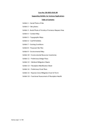
Case No. C8J-2021-0141.0A Supporting Exhibits for Variance Applications Table of Contents Exhibit 3 - Aerial Photo of Vicinity of Variance Request Area Exhibit 1 – Aerial Photo of Site Exhibit 2 – Site photos Exhibit 4 – Context Map Exhibit 5 – Topographic Maps Exhibit 6 – Cut/Fill Exhibits Exhibit 7 – Existing Conditions Exhibit 8 – Proposed Site Plan Exhibit 9 – Environmental Map Exhibit 10 – Environmental Resource Inventories Exhibit 11 – Preliminary Bridge Plans Exhibit 12 – Wetland Mitigation Sheets Exhibit 13 – Floodplain Modification Sheet Exhibit 14 – Preliminary Pond Plans Exhibit 15 – Riparian Zone Mitigation Fund Q7 form Exhibit 16 – Functional Assessment of Floodplain Health Backup page 1 of 188 EXHIBIT 1 – AERIAL PHOTO OF SITE Backup page 2 of 188 E N A L R E M R A P . E TEXAS 130 TEXAS 130 S A L L A D I H T R O W T R O F I N O T S U O H I O I N O T N A N A S I N I T S U A 1 1 7 4.8 5 2.4 1 5 I 9 5 7 8 7 X T TIN, S U A I 0 0 2 E T S 3, G D L B Y, P X E C A P O M N 1 0 8 0 1 1 0 8 8 2 0 0 1 # N O I T A R T S I G E R M R I F S L P B T I 0 7 4 # N O I T A R T S I G E R M R I F E P B T I I T B H X E O T O H P L A R E A I / W N 0 3 1 H S R E M R A P 0 2 0 8 S A X E T , I N T S U A 01 OF 01 Backup page 3 of 188 EXHIBIT 2 – SITE PHOTOS Backup page 4 of 188 ±14.34-ACRE PARMER MF Environmental Resource Inventory Date: 03-30-2021 Photo No. 1 Description: View of the paved portion of the project site facing southeast, on the southeastern corner of the project site. Date: 03-30-2021 Photo No. 2 Description: A typical view of upland habitat that bordered …
ITEM FOR ENVIRONMENTAL COMMISSION AGENDA June 1, 2022 COMMISSION MEETING DATE: NAME & NUMBER OF PROJECT: NAME OF APPLICANT OR ORGANIZATION: Austin Ready Mix Wastewater Service Extension Request #5313 Danny Miller, P.E., LJA Engineering, Inc. LOCATION: 8738 W US 290 Hwy, Austin, Texas 78736 COUNCIL DISTRICT: Austin 2-Mile Extraterritorial Jurisdiction PROJECT FILING DATE: March 29, 2022 WPD/ENVIRONMENTAL STAFF: Kaela Champlin, Environmental Program Coordinator, Watershed Protection Department (512) 974-3443, kaela.champlin@austintexas.gov WATERSHED: REQUEST: STAFF DETERMINATION: Slaughter Creek Watershed, Barton Springs Zone, Edwards Aquifer Contributing Zone, Drinking Water Protection Zone Wastewater Service Extension Staff recommends the wastewater service extension 1 MEMORANDUM TO: FROM: Kevin Ramberg, Chair, and Members of the Environmental Commission Kaela Champlin, Environmental Program Coordinator, Watershed Protection Department May 25, 2022 DATE: SUBJECT: Austin Ready Mix Wastewater Service Extension Request #5313 Service Extension Requests (SER) located in the Drinking Water Protection Zone and outside of the City of Austin’s full purpose jurisdiction require Council approval and review by the Environmental Commission. Watershed Protection Department (WPD) staff have completed the review for 8738 US Hwy 290 West wastewater SER #5313 and recommend the request. Site Overview The site consists of one tract of approximately 4.44 acres, located at 8738 W US 290 Highway in the City of Austin’s 2-mile Extraterritorial Jurisdiction. The applicant is proposing to build an 82,000 square foot warehouse building with 21 Living Unit Equivalents (LUEs). At the time of this review, a site plan has not yet been submitted to the City of Austin. Environmental Impacts The property is in the Slaughter Creek Watershed, the Barton Springs Zone, the Edwards Aquifer Contributing Zone, and the Drinking Water Protection Zone. The site is subject to the Save Our Springs (SOS) Ordinance. An Environmental Resource Inventory was conducted by the applicant, and no known recharge environmental features or critical environmental features were found on site. The site does not contain a critical water quality zone or water quality transition zone and does not drain to known occupied salamander habitat. Development Impacts Water: The applicant is not requesting a water SER for this site. There is a 12-inch water main on-site to connect to Circle Drive that would meet the fire and domestic needs for the proposed development. 2 Wastewater: The applicant is proposing to construct approximately 810 feet of appropriately size force main from the existing 8-inch gravity wastewater main located in Circle Drive near South Bend Avenue west along …
Austin Ready Mix Wastewater Service Extension Request #5313 What is an SER? • A service extension request, or SER, is an application for City water or wastewater service from a property owner or developer. • SERs are required when a property is located more than 100 feet from an accessible water or wastewater system, or when existing infrastructure isn't adequate for the proposed project demands. • Service may involve the construction of a new line or an associated facility or upgrades to existing lines or facilities. • The applicant pays for the associated infrastructure, as outlined in the SER. SER Process • Per the Land Development Code, SERs require Council approval if the property is in the Drinking Water Protection Zone and outside of the City's full purpose jurisdiction. • Environmental Commission and Water & Wastewater Commission review and make recommendations on SERs that require Council approval. • No conditions can be put on approval of SERs. Request Summary • 4.44 acres • 2-Mile ETJ • Slaughter Creek Watershed, Barton Springs Zone • Located in the Edwards Aquifer Contributing Zone • Drinking Water Protection Zone (DWPZ) • Subject to Save Our Springs (SOS) Ordinance Request Summary • Living Unit Equivalent (LUE) is the typical flow that would be produced by a single-family residence located in a typical subdivision. Standard conversions are applied depending on the proposed use to determine the number of LUEs a project will generate. • 82,000² ft warehouse building with 21 LUEs SER #5313 Site Location Austin City Limits Austin ETJ Edwards Aquifer Recharge Zone Edwards Aquifer Contributing Zone Site Location Site Location Limited Purpose 2 Mile ETJ SER #5313 Environmental Impacts • No known Critical Environmental Features • No Critical Water Quality Zone or Water Quality Transition Zones onsite • Does not drain to occupied salamander habitat SER #5313 Proposed Wastewater Extension Map provided by Austin Water Water Service • This SER does not require water service. • There is a 12-inch water main on site to connect to in Circle Drive that would meet the fire and domestic needs for the proposed development. SER #5313 Alternative Wastewater Service If service is not extended, the applicant would have a few other options: 1. On-Site Sewage Facility (OSSF) would be a feasible alternative for the estimated amount of flow. 2. Apply for a Subsurface Area Drip Dispersal System (SADDS) issued by TCEQ. This would require 1.91 acres …
Regular Meeting of the Environmental Commission June 1, 2022 at 6:00 P.M. Permitting and Development Center, Events Center, Room 1405 6310 Wilhelmina Delco Drive, Austin, Texas 78752 Some members of the Environmental Commission will be participating by videoconference. The meeting may be viewed online at: http://www.austintexas.gov/page/watch-atxn-live Public comment will be allowed in-person or remotely by telephone. Speakers may only register to speak on an item once either in-person or remotely and will be allowed up to three minutes to provide their comments. Registration no later than noon the day before the meeting is required for remote participation. To register to speak remotely, call or email the board liaison Kaela Champlin, (512) 974-3443, Kaela.Champlin@austintexas.gov, no later than noon, (the day before the meeting). The following information is required: speaker name, item number(s) they wish to speak on, whether they are for/against/neutral, email address and telephone number (must be the same number that will be used to call into the meeting). COMMISSIONERS: Haris Qureshi (D-1) Rachel Scott (D-2) Pam Thompson (D-3) Melinda Schiera (D-4) Kevin Ramberg (D-8) Chair Audrey Barrett Bixler (D-5) Ana Aguirre (D-9) Colin Nickells (D-6) Richard Brimer (D-10) Jennifer Bristol (D-7) Secretary Perry Bedford (Mayor) Vice-Chair _________________________________________________________________________________ Revised Agenda CALL TO ORDER PUBLIC COMMUNICATION: GENERAL The first 10 speakers who register to speak no later than noon the day before the meeting will be allowed a three-minute allotment to address their concerns regarding items not posted on the agenda. 1 1. 2. 3. APPROVAL OF MINUTES AND ACTION a. Approval of the May 18, 2022 Environmental Commission Regular Meeting Minutes (5 minutes) ITEMS FOR CONSIDERATION AND POSSIBLE ACTION a. Briefing on the 517 Lamar PUD Development Assessment—Heather Chaffin, Housing and Planning Department (30 minutes) PUBLIC HEARINGS a. Consider a proposed annexation of approximately 5.03 acres into Travis County Water Control and Improvement District No. 10, C12M-2022-0001—Andrei Lubomudrov, Housing and Planning Department (30 minutes) b. Name: Sky Mountain, SP-2021-0079C Applicant: Reese Hurley, LJA Engineering, Inc. Location: 8722 W SH 71, Austin, TX 78735 Council District: District 8 Staff: Pamela Abee-Taulli, Environmental Program Coordinator, Development Services Department and Miranda Reinhard, Watershed Protection Department Watershed: Williamson Creek, Barton Springs Zone, Drinking Water Protection Zone Requests: Request to vary from LDC 25-8-341to allow cut over 4 feet to 16 feet. Staff Recommendation: Recommended with conditions (15 minutes) c. Name: 8020 Parmer Lane SH 130 NW, C8J-2021-0141.0A Applicant: Pape-Dawson Engineers, Travis Moltz Location: 8106 …
ITEM FOR ENVIRONMENTAL COMMISSION AGENDA COMMISSION MEETING DATE: June 1, 2022 NAME & NUMBER OF PROJECT: 8020 Parmer Lane SH 130 NW C8J-2021-0141.0A NAME OF APPLICANT OR ORGANIZATION: Pape-Dawson Engineers, Travis Moltz LOCATION: 8106 E PARMER LN, Manor, TX 78653 COUNCIL DISTRICT: Council District does not apply in Extraterritorial Jurisdiction ENVIRONMENTAL REVIEW STAFF: Pamela Abee-Taulli, Environmental Program Coordinator Development Services Department Pamela.abee-taulli@austintexas.gov, 512.974.1879 WATERSHED: REQUEST: Gilleland Creek and Harris Branch Creek Watersheds, Suburban Classification, Desired Development Zone Variance request is as follows: 1. Request to vary from LDC 30-5-342 to allow fill over 4 feet to 15 feet. 2. Request to vary from 30-5-261(G) modification in a critical water quality zone buffer. to allow floodplain STAFF RECOMMENDATION: Staff recommends this variance, having determined the findings of fact to have been met. STAFF CONDITION: Staff recommends the following conditions: 1. The applicant will pay into the Riparian Zone Mitigation Fund for both the area of Zone 1 (Floodplain outside of the CWQZ) and the area of Zone 2 (Floodplain within the CWQZ) using the appropriate ratios per ECM 1.7.6. 2. Development of the site will be carried out as described in Exhibits 1-6, attached in the staff variance packet. Page 1 of 46 Development Services Department Staff Recommendations Concerning Required Findings Project Name: Ordinance Standard: Watershed Protection Ordinance Variance Request: 8020 Parmer Lane SH 130 NW Request to vary from LDC 30-5-342 to allow fill over 4 feet to 15. Include an explanation with each applicable finding of fact. A. City Code: 1. Land Use Commission variance determinations from Chapter 30-5-41 of the The requirement will deprive the applicant of a privilege available to owners of similarly situated property with approximately contemporaneous development subject to similar code requirements. Yes Two roads border the site, SH 130 and Parmer Ln. SH 130 cannot be used for access, because there is a Restriction of Access recorded for SH 130, which TxDOT will not support lifting or modifying for a full access driveway. Regarding Parmer Ln., the entirety of the Parmer Ln. frontage is located within floodplain and creek buffer. In addition, access is blocked by wetlands. Variances have been granted in similarly restrictive circumstances to allow necessary access to a site. The fill variance is required in order for the applicant to access the site with a bridge spanning wetlands, floodplain, and creek buffer. 2. The variance: a) Is not necessitated by the …
Pamela Abee-Taulli Environmental Program Coordinator Development Services Department SKY MOUNTAIN 8722 W SH 71 SP-2021-0079C PROJECT LOCATION 2 [ PROJECT LOCATION 3 [ PROPERTY DATA • Williamson Creek Watershed • Barton Springs Zone Classification • Drinking Water Protection Zone • Full Purpose Jurisdiction • Council District 8 4 [ SITE CONSTRAINTS Existing slopes from 5 to 15% grade. SITE CONSTRAINTS Existing slopes from 5 to 15% grade. SITE CONSTRAINTS Existing slopes from 5 to 15% grade. Created by fill placed on site around 1980. 1976 SITE CONSTRAINTS Existing slopes from 5 to 15% grade. Created by fill placed on site around 1980. 1984 SITE CONSTRAINTS Existing slopes from 5 to 15% grade. Created by fill placed on site around 1980. 1997 SITE CONSTRAINTS Existing slopes from 5 to 15% grade. Created by fill placed on site around 1980. Fill was not compacted as it was placed and is infeasible to build on. 2021 VARIANCE REQUEST § 25-8-341 - CUT REQUIREMENTS. (A) Cuts on a tract of land may not exceed four feet of depth. 1. The variance request is to allow cut over 4 feet to16 feet. 11 GRADING EXHIBIT 12 VARIANCE RECOMMENDATION Removal of the fill and development of the site will reduce the potential for future erosion on these steep, artificially constructed slopes. Staff recommends the variance, with the following conditions. 1. All grading over 8 feet will be contained with terracing or engineered walls. 2. Around the perimeter of the limits of construction, and in areas where more than 3’ of vertical rise is proposed, 3:1 slopes will have erosion control matting applied immediately after final grade is achieved. 3. Disturbance in the stormwater irrigation fields will be minimized by restricting the LOC and routing the irrigation lines to preserve existing trees to the greatest extent possible. THANK YOU Questions?
Pamela Abee-Taulli Environmental Program Coordinator DSD Miranda Reinhard Environmental Scientist Senior WPD 8020 PARMER LANE SH 130 NW 8106 E PARMER LN C8J-2021-0141.0A PROJECT LOCATION 2 PROPERTY DATA • Gilleland Creek & Harris Branch Creek Watersheds • Suburban Classification • Desired Development Zone • Extraterritorial Jurisdiction (Travis County) • Council District: NA 3 PROPERTY DATA • Environmental features: • Critical Water Quality Zone • Wetlands • Wetland Setback • Floodplain 4 SITE CONSTRAINT • Environmental features: • Critical Water Quality Zone • Wetlands • Wetland Setback • Floodplain • The only allowable site access is from Parmer Ln. • A driveway at this location must cross the CWQZ, wetlands, and floodplain in order to access the site. 5 CWQZ Wetlands Wetland Setback Floodplain Access VARIANCE REQUESTS §30-5-342 FILL REQUIREMENTS. Fill on a tract of land may not exceed four feet of depth. 1. The variance request is to vary from LDC 30-5-342 to allow fill over 4 feet to 15 feet. § 30-5-261 (G) – CRITICAL WATER QUALITY ZONE DEVELOPMENT. (G) Floodplain modifications prohibited in the CWQZ unless one of the exemptions is met. 2. The variance request is to allow floodplain modification for development within the CWQZ. 6 VARIANCE REQUEST 1 §30-5-342 Fill over 4 feet to 15 feet. • Access from SH 130 is prohibited by TXDOT. • Access from Parmer Ln. requires a bridge to cross CWQZ, wetlands, & floodplain The fill is the minimum necessary to build the bridge high enough for safe access over the 100-yr. flood elevation. 7 SH 130 Access PROPOSED BRIDGE 100-YR FLOOD ELEVATION EXISTING GRADE FILL 4’-8’ FILL > 8’ VARIANCE REQUEST 2 § 30-5-261(G) • Floodplain modifications are prohibited in the CWQZ Bridge VARIANCE REQUEST 2 § 30-5-261(G) • Floodplain modifications are prohibited in the CWQZ 10 VARIANCE REQUEST 2 Functional Assessment of Floodplain Health (ECM Appendix X): • Floodplain is in “Fair” condition • Excellent Good Fair Poor 11 VARIANCE REQUEST 2 Floodplain Restoration/Mitigation • Not enough area to restore on-site due to highly constrained site • Mitigation fee 12 VARIANCE REQUEST 2 Floodplain Modification ECM 1.7.6 Mitigation Ratios Total Modification Area: 2.69 Acres • • Zone 1 (Floodplain outside the CWQZ) 0.192 acres (Mitigated) • Zone 2 (Floodplain within the CWQZ) • 0.064 acres • Fair 3:1 • • 2.626 acres • Fair 6:1 • 15.756 acres (Mitigated) • Total Mitigation Area: 15.948 Acres 13 …

ITEM FOR ENVIRONMENTAL COMMISSION AGENDA June 1, 2022 COMMISSION MEETING DATE: NAME & NUMBER OF PROJECT: NAME OF APPLICANT OR ORGANIZATION: Austin Ready Mix Wastewater Service Extension Request #5313 Danny Miller, P.E., LJA Engineering, Inc. LOCATION: 8738 W US 290 Hwy, Austin, Texas 78736 COUNCIL DISTRICT: Austin 2-Mile Extraterritorial Jurisdiction PROJECT FILING DATE: March 29, 2022 WPD/ENVIRONMENTAL STAFF: Kaela Champlin, Environmental Program Coordinator, Watershed Protection Department (512) 974-3443, kaela.champlin@austintexas.gov WATERSHED: REQUEST: STAFF DETERMINATION: Slaughter Creek Watershed, Barton Springs Zone, Edwards Aquifer Contributing Zone, Drinking Water Protection Zone Wastewater Service Extension Staff recommends the wastewater service extension 1 MEMORANDUM TO: FROM: Kevin Ramberg, Chair, and Members of the Environmental Commission Kaela Champlin, Environmental Program Coordinator, Watershed Protection Department June 1, 2022 DATE: SUBJECT: Austin Ready Mix Wastewater Service Extension Request #5313 Service Extension Requests (SER) located in the Drinking Water Protection Zone and outside of the City of Austin’s full purpose jurisdiction require Council approval and review by the Environmental Commission. Watershed Protection Department (WPD) staff have completed the review for 8738 US Hwy 290 West wastewater SER #5313 and recommend the request. Site Overview The site consists of one tract of approximately 4.44 acres, located at 8738 W US 290 Highway in the City of Austin’s 2-mile Extraterritorial Jurisdiction. The applicant is proposing to build an 82,000 square foot warehouse building with 21 Living Unit Equivalents (LUEs). At the time of this review, a site plan has not yet been submitted to the City of Austin. Environmental Impacts The property is in the Slaughter Creek Watershed, the Barton Springs Zone, the Edwards Aquifer Contributing Zone, and the Drinking Water Protection Zone. The site is subject to the Save Our Springs (SOS) Ordinance. An Environmental Resource Inventory was conducted by the applicant, and no known recharge environmental features or critical environmental features were found on site. The site does not contain a critical water quality zone or water quality transition zone and does not drain to known occupied salamander habitat. Development Impacts Water: The applicant is not requesting a water SER for this site. There is a 12-inch water main on-site to connect to Circle Drive that would meet the fire and domestic needs for the proposed development. 2 Wastewater: The applicant is proposing to construct approximately 810 feet of appropriately size force main from the existing 8-inch gravity wastewater main located in Circle Drive near South Bend Avenue west along …
Austin Ready Mix Wastewater Service Extension Request #5313 What is an SER? • A service extension request, or SER, is an application for City water or wastewater service from a property owner or developer. • SERs are required when a property is located more than 100 feet from an accessible water or wastewater system, or when existing infrastructure isn't adequate for the proposed project demands. • Service may involve the construction of a new line or an associated facility or upgrades to existing lines or facilities. • The applicant pays for the associated infrastructure, as outlined in the SER. SER Process • Per the Land Development Code, SERs require Council approval if the property is in the Drinking Water Protection Zone and outside of the City's full purpose jurisdiction. • Environmental Commission and Water & Wastewater Commission review and make recommendations on SERs that require Council approval. • No conditions can be put on approval of SERs. Request Summary • 4.44 acres • 2-Mile ETJ • Slaughter Creek Watershed, Barton Springs Zone • Located in the Edwards Aquifer Contributing Zone • Drinking Water Protection Zone (DWPZ) • Subject to Save Our Springs (SOS) Ordinance Request Summary • Living Unit Equivalent (LUE) is the typical flow that would be produced by a single-family residence located in a typical subdivision. Standard conversions are applied depending on the proposed use to determine the number of LUEs a project will generate. • 82,000² ft warehouse building with 21 LUEs SER #5313 Site Location Austin City Limits Austin ETJ Edwards Aquifer Recharge Zone Edwards Aquifer Contributing Zone Austin City LimitsETJRechargeContributingAustin City LimitsETJRechargeContributing Site Location Site Location Limited Purpose 2 Mile ETJ SER #5313 Environmental Impacts • No known Critical Environmental Features • No Critical Water Quality Zone or Water Quality Transition Zones onsite • Does not drain to occupied salamander habitat SER #5313 Proposed Wastewater Extension Map provided by Austin Water Water Service • This SER does not require water service. • There is a 12-inch water main on site to connect to in Circle Drive that would meet the fire and domestic needs for the proposed development. SER #5313 Alternative Wastewater Service If service is not extended: 1. On-Site Sewage Facility (OSSF) would not be a feasible alternative for the estimated amount of flow. 2. Apply for a Subsurface Area Drip Dispersal System (SADDS) issued by TCEQ. This would require 1.91 acres for a …
Play video
ENVIRONMENTAL COMMISSION MOTION 20220601 003a Date: June 1, 2022 Subject: Proposed annexation of approximately 5.03 acres into Travis County Water Control and Improvement District No. 10, C12M-2022-0001 Motion by: Jennifer Bristol Seconded by: Melinda Schiera RATIONALE: WHEREAS, the Environmental Commission recognizes the annexation into the District will not affect the City of Austin’s annexation plans and staff does not anticipate any negative land use impacts on adjacent property; WHEREAS, the Environmental Commission recognizes that staff finds that direct water and wastewater service is not feasible given the location of the property in relation to Austin Water’s system with water and wastewater services approximately 1.25 miles away from the site; and WHEREAS, the Environmental Commission recognizes that the regulations for development will follow the same rules and processes currently in effect if the District annexes the tract. THEREFORE, the Environmental Commission recommends consent to the proposed annexation of the 5.03- acre tract into the Travis County Water Control and Improvement District No. 10. VOTE 9-0 For: Scott, Thompson, Schiera, Nickells, Bristol, Ramberg, Aguirre, Brimer, Bedford Against: None Abstain: None Recuse: Note Absent: Qureshi and Barrett Bixler Approved By: Kevin Ramberg, Environmental Commission Chair 1
1 ENVIRONMENTAL COMMISSION MOTION 20220601 003b Date: June 1, 2022 Subject: Sky Mountain, SP-2021-0079C Seconded by: Kevin Ramberg Motion by: Jennifer L. Bristol RATIONALE: WHEREAS, the Environmental Commission recognizes the applicant is requesting a variance from LDC 25- 8-341 to allow cut over 4 feet to 16 feet; and WHEREAS, the Environmental Commission recognizes the site is located in the Williamson Creek, Barton Springs Zone Classification, Drinking Water Protection Zone; and WHEREAS, the Environmental Commission recognizes that Staff recommends this variance, (with three staff conditions) having determined the required Findings of Fact have been met. THEREFORE, the Environmental Commission recommends the variance request with the following: Staff Conditions: 1. All grading over 8 feet will be contained with terracing or engineered walls. 2. Around the perimeter of the limits of construction, and in areas where more than 3’ of vertical rise is proposed, 3:1 slopes will have erosion control matting applied immediately after final grade is achieved. 3. Disturbance in the stormwater irrigation fields will be minimized by restricting the LOC and routing the irrigation lines to preserve existing trees to the greatest extent possible. VOTE 8-0 Approved By: For: Thompson, Schiera, Nickells, Bristol, Ramberg, Aguirre, Brimer, Bedford Against: None Abstain: None Recuse: None Absent: Qureshi, Scott, and Barrett Bixler Kevin Ramberg, Environmental Commission Chair
1 ENVIRONMENTAL COMMISSION MOTION 20220601 003c Date: June 1, 2022 Seconded by: Ana Aguirre Subject: 8020 Parmer Lane, SH 130 NW C8J-2021-0141.0A Motion by: Jennifer Bristol RATIONALE: WHEREAS, the Environmental Commission recognizes the applicant is requesting a variance from LDC 30- 5-342 to allow fill over 4 feet to 15 feet and to vary from 30-5-261(G) to allow floodplain modification in a critical water quality zone buffer; and WHEREAS, the Environmental Commission recognizes the site is located in the Gilleland Creek and Harris Branch Creek Watersheds, Suburban Classification, Desired Development Zone; and WHEREAS, the Environmental Commission recognizes that Staff recommends this variance, (with two staff conditions) having determined the required Findings of Fact have been met. THEREFORE, the Environmental Commission recommends the variance request with the following: Staff Conditions: 1. The applicant will pay into the Riparian Zone Mitigation Fund for both the area of Zone 1 (Floodplain outside of the CWQZ) and the area of Zone 2 (Floodplain within the CWQZ) using the appropriate ratios per ECM 1.7.6. 2. Development of the site will be carried out as described in Exhibits 1-6, attached in the staff variance packet. VOTE 9-0 Approved By: For: Scott, Thompson, Schiera, Nickells, Bristol, Ramberg, Aguirre, Bristol, Bedford Against: None Abstain: None Recuse: None Absent: Qureshi and Barrett Bixler Kevin Ramberg, Environmental Commission Chair
1 ENVIRONMENTAL COMMISSION MOTION 20220601 003d Date: June 1, 2022 Subject: Austin Ready Mix Wastewater Service Extension Request #5313 Motion by: Jennifer Bristol Seconded by: Perry Bedford RATIONALE: WHEREAS, the Environmental Commission recognizes the applicant is requesting a Wastewater Service Extension; and WHEREAS, the Environmental Commission recognizes the site is located in the Slaughter Creek Watershed, Barton Springs Zone, Edwards Aquifer Contributing Zone, Drinking Water Protection Zone; and WHEREAS, the Environmental Commission recognizes that staff recommends the wastewater service extension. THEREFORE, the Environmental Commission recommends wastewater Service Extension Request #5313. VOTE 6-3 For: Thompson, Schiera, Nickells, Ramberg, Aguirre, Bedford Against: None Abstain: Scott, Bristol, Brimer Recuse: None Absent: Qureshi, Barrett Bixler Approved By: Kevin Ramberg, Environmental Commission Chair
Regular Meeting of the Environmental Commission May 18, 2022 at 6:00 P.M. Permitting and Development Center, Events Center, Room 1406 6310 Wilhelmina Delco Drive, Austin, Texas 78752 Some members of the Environmental Commission will be participating by videoconference. The meeting may be viewed online at: http://www.austintexas.gov/page/watch-atxn-live Public comment will be allowed in-person or remotely by telephone. Speakers may only register to speak on an item once either in-person or remotely and will be allowed up to three minutes to provide their comments. Registration no later than noon the day before the meeting is required for remote participation. To register to speak remotely, call or email the board liaison Kaela Champlin, (512) 974-3443, Kaela.Champlin@austintexas.gov, no later than noon, (the day before the meeting). The following information is required: speaker name, item number(s) they wish to speak on, whether they are for/against/neutral, email address and telephone number (must be the same number that will be used to call into the meeting). COMMISSIONERS: Haris Qureshi (D-1) Rachel Scott (D-2) Pam Thompson (D-3) Melinda Schiera (D-4) Kevin Ramberg (D-8) Chair Audrey Barrett Bixler (D-5) Ana Aguirre (D-9) Colin Nickells (D-6) Richard Brimer (D-10) Jennifer Bristol (D-7) Secretary Perry Bedford (Mayor) Vice-Chair _________________________________________________________________________________ Agenda CALL TO ORDER PUBLIC COMMUNICATION: GENERAL The first 10 speakers who register to speak no later than noon the day before the meeting will be allowed a three-minute allotment to address their concerns regarding items not posted on the agenda. 1 1. 2. 3. 4. APPROVAL OF MINUTES AND ACTION a. Approval of the May 4, 2022 Environmental Commission Regular Meeting Minutes (5 minutes) ENVIRONMENTAL OFFICER UPDATES a. Update on Samsung wastewater spill—Katie Coyne, Environmental Officer, Watershed Protection Department (5 minutes) ITEMS FOR CONSIDERATION AND POSSIBLE ACTION a. Discuss and consider an ordinance amending Title 25 of the City Code related to floodplain regulations. City Staff: Kevin Shunk and Jameson Courtney, Watershed Engineering Division Manager, Watershed Protection Department (30 minutes) b. Discuss and consider a recommendation on proposed changes to City Land Development Code Title 25 (§ 25-1, § 25-2, § 25-8) to address challenges to the successful design and construction of public mobility projects in the right-of-way (30 minutes) PUBLIC HEARINGS a. Name: 1881 Westlake Drive, SP-2021-0349D Applicant: Joseph William Lee Location: 1881 Westlake Drive, Austin, Texas 78746 Council District: District 8 Staff: Eric Brown, Senior Environmental Scientist, Watershed Protection Department Watershed: Lake Austin and Bee Creek watersheds, Water Supply …
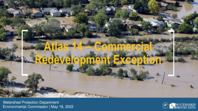
Atlas 14 – Commercial Redevelopment Exception Watershed Protection Department Environmental Commission | May 18, 2022 Floodplain Regulations Update What floodplain rules did we update? What floodplain rules do we recommend updating now? 2 What floodplain rules did we update? Most significant update to our floodplain rules in their 36-year history Goal of updated rules: Protect our residents from flooding based on a better understanding of flood risk with new rainfall information Updated four basic elements of rules • Floodplain definitions • Residential redevelopment exception • Colorado River exception • Freeboard 3 Floodplain Definitions Regulatory 100-yr floodplain = Current FEMA 500-yr floodplain Regulatory 25-yr floodplain = Old COA 100-yr floodplain • Maintain the City’s level of flood protection • Limit construction of new buildings in areas with known flood risk during re- mapping process • Interim definitions until floodplains are re-mapped in 2 - 3 years 4 Residential Redevelopment Exception Administrative approval process floodplain if: 1. Replacement or modification of an existing residential building 2. Does not increase number of dwelling units 3. Finished floor elevation is at least 2 feet above the 100-year floodplain 4. No adverse flooding impact If these 4 conditions are met, the safe access requirement is waived Purpose • Incentivizes development that decreases flood risk • 80% of buildings in the 100-year floodplain are residential • Doesn’t increase the number of dwelling units at risk of flooding • Opens up opportunity for grant Existing condition Re-developed condition funding 5 Option for Minor Improvements to Residential Buildings Administrative approval process for an addition to a residential building in the floodplain if: 1. Finished floor elevation of the addition is at least 2 feet above the 100-year floodplain 2. Not a substantial improvement 3. No adverse flooding impact If these 3 conditions are met, the safe access requirement is waived 6 Colorado River Exception The previous exception allowed for a building to encroach in the 100-year floodplain if it was: • Downstream of Longhorn Dam • Along Lady Bird Lake New rule expands this exception to include: • Lake Austin • Lake Travis (within COA jurisdiction) Lake Travis Purpose • Provide uniform regulations along Colorado River • Colorado River flooding is not flash flooding like rest of City Lake Austin Lady Bird Lake Colorado River downstream of Longhorn Dam 7 7 Freeboard Increase the minimum height between a building’s finished floor and the 100-year floodplain from 1 ft …
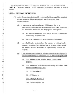
1 2 3 4 5 6 7 8 9 10 11 12 13 14 15 16 17 18 19 20 21 22 23 24 25 26 DRAFT HAS NOT RECEIVED FINAL REVIEW BY LAW DEPARTMENT PART 1. City Code Section 25-7-93 (General Exceptions) is amended to read as follows: § 25-7-93 GENERAL EXCEPTIONS. (A) A development application with a proposed building or parking area that encroaches on the 100-year floodplain may be approved if the encroachment is: (1) a parking area that is smaller than 5,000 square feet or an unoccupied structure that has an area of less than 1,000 square feet, and the director determines that the proposed development: (a) will not have an adverse effect on the 100-year floodplain or surrounding properties; and (b) otherwise complies with the requirements of this title; (2) a new building for residential use that replaces an existing legally constructed building for residential use on the same property and that does not increase the number of legal dwelling units on the property; (3) a new building for commercial use that replaces an existing legally constructed building for commercial use on the same property and: (a) (b) does not increase the building square footage on the property; does not include the following uses as they are defined in the International Building Code: (i) E (Educational); (ii) F (Factory); (iii) H (High Hazard); or (iv) I (Institutional); and Page 1 of 4 1 2 3 4 5 6 7 8 9 10 11 12 13 14 15 16 17 18 19 20 21 22 23 24 25 DRAFT HAS NOT RECEIVED FINAL REVIEW BY LAW DEPARTMENT (c) does not increase the flood level of parking spaces within the 100-year floodplain unless additional parking is required by another section of this title. (4)[(3)] a building authorized by a waterway development permit issued under Chapter 9-10 before September 25, 1983; or (5)[(4)] a building in the 100-year floodplain of: (b) the Colorado River downstream from Longhorn Dam; (a) Lady Bird Lake; (c) Lake Austin; or (d) Lake Travis. (B) To be approved under this section, development must: (1) be no lower than two feet above the 100-year floodplain, as measured from the lowest floor elevation of any proposed building; (2) (3) (4) comply with the requirements in Chapter 25-12, Article 1, Section 25-12-3 Appendix G (Flood Resistant Construction) and Section 1612 (Flood Loads); compensate for the floodplain …
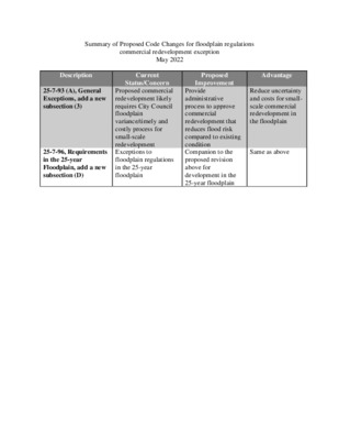
Summary of Proposed Code Changes for floodplain regulations commercial redevelopment exception May 2022 Description 25-7-93 (A), General Exceptions, add a new subsection (3) 25-7-96, Requirements in the 25-year Floodplain, add a new subsection (D) Current Status/Concern Proposed commercial redevelopment likely requires City Council floodplain variance/timely and costly process for small-scale redevelopment Exceptions to floodplain regulations in the 25-year floodplain Proposed Improvement Provide administrative process to approve commercial redevelopment that reduces flood risk compared to existing condition Companion to the proposed revision above for development in the 25-year floodplain Advantage Reduce uncertainty and costs for small- scale commercial redevelopment in the floodplain Same as above
RESOLUTION NO. 20220303-028 WHEREAS, in August 2016, City Council approved Resolution No. 20160818-07 4 that expressed Council's intent to contract with voters for a Mobility Bond election in November 2016 and directed the City Managerto analyze existing capital project delivery systems and processes in order to recommend potential changes and resource requirements to complete the bond program within eight years from initiation; and WHEREAS, in March 2019, City Council approved Resolution No. 20190328-040 that affirmed the City of Austin's desire to construct as many miles of progressive multi-modal mobility infrastructure as quickly as it can to facilitate congestion relief, safety, and environmental stewardship, and encouraged the City Manager to form a steering committee of representatives from relevant departments to align resources, priorities, and policies that support an accelerated timetable for planned bicycle, scooter, transit, sidewalks, and tier one urban trail and, infrastructure projects; WHEREAS, in August 2019, City Council approved Resolution N o. 20190808-081 that directed the City Manager to analyze and report on options for the City to leverage resources to support the creation, operation, and maintenance of a high-capacity transit system; and, WHEREAS, in August 2020, City Council approved Resolution N o. 20200807-003 that expressed Council's intent to contract with the voters for a citywide rapid transit system (to be known as "Project Connect") that will include four MetroRapid lines to be constructed and operational within five years, and two light rail lines to be constructed within and operational ten years; and, Page 1 of 5 WHEREAS, in August 2020, City Council approved Resolution No. 20200812-011 that expressed Council's intent to contract with the voters fora Mobility Bond election in November 2020, and directed the City Manager to analyze existing capital project delivery systems and processes in order to recommend potential changes and resource requirements to accelerate project delivery and maximize the number ofprojects to be completed within six years; and, WHEREAS, in October 2021, City Council approved Resolution No. 20211029-003 that directed the City Manager to review City Code, including, but not limited to, the Land Development Code, Criteria Manuals, and permitting procedures to identify impediments to the design, construction, implementation, and operation of Project Connect, and to present any Code amendments necessary to City Council no later than April 2022; and, WHEREAS, public mobility projects in the right-of-way offer tremendous community benefits, including improved multimodal access and accessibility for individuals with disabilities, enhanced life safety, greater …
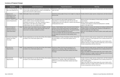
Summary of Proposed Changes Type of Change Clarify (Exemptions) of City Code Chapter 25-2, amend Subchapter E 3 25-8-211 (Water Quality Control Requirement) 4 25-8-214 (Optional Payment Instead of Structural Controls in Urban Watersheds) Description Current Status/Concern Proposed Improvement Advantage 1 25-1-112 Fiscal Security, add a new Subsection (F) Fiscal security is primarily intented for private development. The City has other existing mechanisms in place to accomplish the intent of this section for public projects. Clarify that a public project is not required to post fiscal security under this title. Provides clarity for project sponsors, design teams, and Code reviewers. 2 Section 1.2.4. Clarify Public right-of-way is not zoned land. Provides clarity for project sponsors, design teams, and Code reviewers. Clarify that roadway rights-of-way are not subject to zoning and land use rules. Policy Current requirements for calculating impervious cover do not allow a credit for removal of existing impervious. Calculations are done on a "site" basis, translation of site to linear projects in the right-of-way needed. A single mobility project may cross multiple watersheds. Policy Roadway projects have limited land area available to provide space for water quality controls within the right-of-way and vacant land is not always available for purchase. Revise procedure for water quality calculations to be determined on a watershed basis rather than for the total mobility project area and to allow for a credit for the removal of existing impervious cover. Removes barriers to the delivery of critical safety and mobility improvements. Reduces reliance on waivers and variances. Translates code written for commercial development to mobility projects in the right-of-way. 5 25-8-262 (Critical Water Quality Zone Street Crossings) Clarify Current requirements are not clear that rail lines, like roadways, are able to cross critical water quality zones. Creates a Public Mobility Projects Structural Control Fund for payment-in-lieu of built improvements in all watersheds of the City except the Barton Springs Zone. The payment shall be based on a formula established by the Council. As funds accumulate, they City can best direct the use of funds for the design and construction of water quality control facilities. Clarify definitions of types of roadways and that railways have the same ability to cross critical water quality zones as roadways. 6 25-8-341 (Cut Requirements) Clarify Current requirements are not clear that rail lines, like roadways, are able to cross critical water quality zones. Clarify that railways have the …