20220601-003b: Sky Mountain SP-2021-0079C variance packet — original pdf
Backup
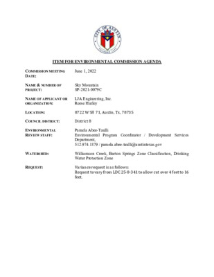
ITEM FOR ENVIRONMENTAL COMMISSION AGENDA COMMISSION MEETING DATE: June 1, 2022 NAME & NUMBER OF PROJECT: Sky Mountain SP-2021-0079C NAME OF APPLICANT OR ORGANIZATION: LJA Engineering, Inc. Reese Hurley LOCATION: 8722 W SH 71, Austin, Tx, 78735 COUNCIL DISTRICT: District 8 ENVIRONMENTAL REVIEW STAFF: WATERSHED: REQUEST: Pamela Abee-Taulli Environmental Program Coordinator / Development Services Department, 512.974.1879 / pamela.abee-taulli@austintexas.gov Williamson Creek, Barton Springs Zone Classification, Drinking Water Protection Zone Variance request is as follows: Request to vary from LDC 25-8-341 to allow cut over 4 feet to 16 feet. STAFF RECOMMENDATION: Staff recommends this variance, having determined the findings of fact to have been met. STAFF CONDITION: Staff recommends the following conditions: 1. All grading over 8 feet will be contained with terracing or engineered walls. 2. Around the perimeter of the limits of construction, and in areas where more than 3’ of vertical rise is proposed, 3:1 slopes will have erosion control matting applied immediately after final grade is achieved. 3. Disturbance in the stormwater irrigation fields will be minimized by restricting the LOC and routing the irrigation lines to preserve existing trees to the greatest extent possible. Page 2 of 2 Development Services Department Staff Recommendations Concerning Required Findings Project Name: Ordinance Standard: Watershed Protection Ordinance Variance Request: Sky Mountain Request to vary from LDC 25-8-341 to allow cut over 4 feet to 16 feet. Include an explanation with each applicable finding of fact. A. City Code: Land Use Commission variance determinations from Chapter 25-8-41 of the 1. The requirement will deprive the applicant of a privilege available to owners of similarly situated property with approximately contemporaneous development subject to similar code requirements. Yes The existing site conditions include areas of previously imported fill material that occurred prior to the adoption of developmental regulations requiring site plan applications. According to aerial information, the fill dates back to the early 1980s. As such the existing conditions do not represent the grades that would have occurred naturally. Because the fill has very steep slopes and is not compacted, it is not suitable for building on. This is why the applicant proposes to cut back the fill to such a degree. 2. The variance: a) Is not necessitated by the scale, layout, construction method, or other design decision made by the applicant, unless the design decision provides greater overall environmental protection than is achievable without the variance; Yes The variance is not necessitated by design decisions made by the applicant. The variance is necessitated by up to 20 feet of uncompacted fill that was placed on the site in the early 1980s, before this area was annexed by the City. The fill was placed in an uncontrolled manner that is not viable to build on, making it infeasible to develop the property without removing much of it. The removal of the fill and development of the site in will reduce the potential for erosion on these man-made steep slopes. Is the minimum deviation from the code requirement necessary to allow a reasonable use of the property; Yes The proposed grading is the minimum necessary to develop the site. The placement of fill on the property within the subject area created an un-natural embankment that cannot be developed upon. The man-made slopes have a gradient as steep as 50 percent and are steeper than desirable for development. Moreover, the fill contains unsuitable material. The development proposed cut up to 16 feet, which is the minimum necessary to level and stabilize the site. Does not create a significant probability of harmful environmental consequences. Yes The development would not create a probability of harmful environmental consequences. It would improve the environment by minimizing erosion and removing improperly compacted fill. Although the subject area has naturally revegetated over time, the possibility of harmful erosion occurring is still a valid concern if the slopes are left. Code-compliant erosion and sedimentation controls will be provided both during and after construction activities. All grading will be permanently stabilized in a code- complaint fashion. 3. Development with the variance will result in water quality that is at least equal to the water quality achievable without the variance. Yes Water quality will be provided in accordance with current City of Austin standards, therefore it will be equal to the water quality that would be provided without the variance. Because this site is in the Barton Springs Zone, water quality controls will meet the “non-degradation” standard required by the Save Our Springs ordinance. This means that runoff from the site shall cause no net increase in average annual pollutant load compared to existing conditions. Storm water detention for ATLAS-14 flood flows is also being provided. b) c) B. The Land Use Commission may grant a variance from a requirement of Section 25-8-422 (Water Supply Suburban Water Quality Transition Zone), Section 25-8- 452 (Water Supply Rural Water Quality Transition Zone), Section 25-8-482 (Barton Springs Zone Water Quality Transition Zone), Section 25-8-368 (Restrictions on Development Impacting Lake Austin, Lady Bird Lake, and Lake Walter E. Long), or Article 7, Division 1 (Critical Water Quality Zone Restrictions ), after determining that:: 1. 2. 3. The criteria for granting a variance in Subsection (A) are met; NA The requirement for which a variance is requested prevents a reasonable, economic use of the entire property; NA The variance is the minimum deviation from the code requirement necessary to allow a reasonable, economic use of the entire property. NA Staff Determination: Staff determines that the findings of fact have been met. Staff recommends the following conditions: 1. All grading over 8 feet will be contained with terracing or engineered walls. 2. Around the perimeter of the limits of construction, and in areas where more than 3’ of vertical rise is proposed, 3:1 slopes will have erosion control matting applied immediately after final grade is achieved. 3. Disturbance in the stormwater irrigation fields will be minimized by restricting the LOC and routing the irrigation lines to preserve existing trees to the greatest extent possible. Environmental Reviewer (DSD) Environmental Review Manager (DSD) Deputy Environmental Officer (WPD) __________________ (Pamela Abee-Taulli) __________________ (Mike McDougal) __________________ (Liz Johnston) Date: 4/27/22 Date: 5/6/22 Date: 05/23/2020 April 22, 2022 ENVIRONMENTAL COMMISSION VARIANCE APPLICATION FORM Street Address LJA Engineering, 7500 Rialto Blvd, Bldg 2, Ste 100 PROJECT DESCRIPTION Applicant Contact Information Name of Applicant S. Danny Miller, P.E. City State ZIP Code Austin, TX 78735 Work Phone (512) 439-4700 E-Mail Address dmiller@LJA.com Variance Case Information Case Name Sky Mountain Case Number SP-2021-0079C Address or Location 8722 W. SH 71, Austin, TX 78735 Environmental Reviewer Name Environmental Resource Management Reviewer Name Pamela Abee-Taulli Applicable Ordinance Watershed Protection Ordinance / Current code Watershed Name Williamson Creek Watershed Classification ☐Urban ☐ Suburban ☐Water Supply Suburban ☐Water Supply Rural X Barton Springs Zone City of Austin | Environmental Commission Variance Application Guide 1 April 22, 2022 Edwards Aquifer Recharge Zone ☐ Barton Springs Segment ☐ Northern Edwards Segment X Not in Edwards Aquifer Zones Edwards Aquifer Contributing Zone Distance to Nearest Classified Waterway Water and Waste Water service to be provided by X Yes ☐ No Approximately 130’ to the east. Austin Water Request The variance request is as follows (Cite code references): Request to vary from LDC §25-8-341 Cut Requirements to allow cut above 4 feet in the subject area within the Barton Springs Zone. The below reported impervious cover is that just for the northern part of the project, as explained in the provided summary letter. Impervious cover square footage: acreage: percentage: Provide general description of the property (slope range, elevation range, summary of vegetation / trees, summary of the geology, CWQZ, WQTZ, CEFs, floodplain, heritage trees, any other notable or outstanding characteristics of the property) Existing 0 SF 0 AC. 0% Proposed 184,888 4.244 AC. 24.28% The subject area within the overall project that dictates this required variance is approximately 6.72 acres in size and is located within the existing Mountain Shadows Subdivision. Existing earthen slopes in the subject area range from 5% up to 50% as shown on the existing slope map exhibit. Approximately 75% of the existing slopes within the overall subject were created by the placement of fill that occurred sometime during the early 1980’s. A high elevation of 1,013 ft-msl occurs in the SE corner of existing Lot Q of Mountain Shadows Subdivision with a low elevation of approximately 955 ft-msl on existing Lot P of Mountain Shadows Subdivision. The subject property is characterized by Edward Plateau, Deciduous Oak/Evergreen Motte and Woodland, Ashe Juniper Motte and Woodland, and Ashe Juniper - Live Oak Shrubland (TPWD, 2020). The majority of the vegetation on the subject property are Ashe Juniper, Sugar Hackberry, and Cedar Elm. There are two Heritage Trees within the subject area that will not be affected by the proposed grading of the site. There is not an existing or required City of Austin 100-Year Floodplain delineation or waterway on the property dictating a required CWQZ and WQTZ. There is not an applicable FEMA 100-Year Floodplain per FEMA FIRM No. 48453C0420J, dated 01/22/2020. As indicated in the ERI, there are no applicable CEF’s. City of Austin | Environmental Commission Variance Application Guide 2 April 22, 2022 FINDINGS OF FACT Project: Sky Mountain Ordinance: 20131017-046 A. 1. Clearly indicate in what way the proposed project does not comply with current Code (include maps and exhibits) The proposed project would not be able to meet the cut requirements of 25-8-341. The project must remove a substantial amount of fill that was placed by previous owners in the early 1980’s. The removal of the fill in the subject area will exceed the maximum allowed 4’ cut requirement per COA LDC 25-8-341 as shown by the attached cut and fill exhibit and cross sections. Additionally, the required amount of cut cannot be allowed by an administrative variance per COA LDC 25-8-42 and the project is located in the BSZ. As required in LDC Section 25-8-41, in order to grant a variance the Land Use Commission must make the following findings of fact: Include an explanation with each applicable finding of fact. Land Use Commission variance determinations from Chapter 25-8-41 of the City Code: The requirement will deprive the applicant of a privilege available to owners of similarly situated property with approximately contemporaneous development subject to similar code requirements. Yes, because the placement of uncompacted fill in the subject area created unnatural embankments with fills up to approximately 20’ in the worst-case areas that were not the result of any action performed by the current landowner, thus causing a condition that makes it infeasible to develop the property without removing up to 20’ of fill material in the worst-case areas. Additionally, this material was placed in an uncontrolled manner that is not viable to build on. 2. The variance: a) Is not necessitated by the scale, layout, construction method, or other design decision made by the applicant, unless the design decision provides greater overall environmental protection than is achievable without the variance; Yes, the variance is not necessitated because of scale, layout, construction method, or design decision but because of previously placed fill that has caused City of Austin | Environmental Commission Variance Application Guide 3 April 22, 2022 a hardship on the property for purposes of the proposed development. Not granting the variance would require the development to occur on land that is currently proposed to remain natural, versus being located on previously disturbed land. The proposed design of the project will provide water quality controls for the entire proposed project in accordance with current City of Austin Regulations for projects located in the Barton Springs Zone (SOS Standards). The removal of the placed fill and development of the site in general will reduce the potential for erosion on the man-made steep slopes. Is the minimum deviation from the code requirement necessary to allow a reasonable use of the property; Yes, the placement of fill on the property within the subject area created an un- natural embankment and associated slopes in the subject area that cannot be developed upon. The property is to be developed with multifamily apartments and associated site improvements. If the variance is not approved the site becomes undevelopable due to a private restrictive covenant with the adjacent community that prohibits access to Mountain Shadows Drive. Non approval of the variance would require disturbance of existing natural area rather than previously disturbed area. Does not create a significant probability of harmful environmental consequences. Yes, development with the variance does not create a probability of harmful environmental consequences. The development would in fact improve the environment by minimizing erosion and removing improperly compacted fill. The project will remove a substantial amount of fill that was placed on the site in the early 1980’s which was not conditioned and therefore is not suitable for development purposes. Although the subject area has naturally revegetated over time, the man-made slopes that were created in the subject area are steeper than desirable for development and contain unsuitable material. The possibility of harmful erosion occurring over time is still a valid concern on the man-made slopes if left to remain. b) c) Code-compliant erosion and sedimentation controls will be provided both during and after construction activities. All grading will be permanently stabilized in a code-complaint fashion. 3. Development with the variance will result in water quality that is at least equal to the water quality achievable without the variance. Yes, water quality will be provided in accordance with current City of Austin standards, therefore code-compliant and equal to the water quality that would be provided without the variance. Because this site is in the Barton Springs Zone, water quality controls will meet the “non-degradation” standard required City of Austin | Environmental Commission Variance Application Guide 4 April 22, 2022 by the Save Our Springs ordinance. This means that runoff from the site shall cause no net increase in average annual pollutant load compared to existing conditions. Storm water detention for ATLAS-14 flows is also being provided. B. Additional Land Use Commission variance determinations for a requirement of Section 25-8-422 (Water Quality Transition Zone), Section 25-8-452 (Water Quality Transition Zone), Article 7, Division 1 (Critical Water Quality Zone Restrictions), or Section 25-8-368 (Restrictions on Development Impacting Lake Austin, Lady Bird Lake, and Lake Walter E. Long): 1. 2. 3. The criteria for granting a variance in Subsection (A) are met; Not Applicable The requirement for which a variance is requested prevents a reasonable, economic use of the entire property; Not Applicable The variance is the minimum deviation from the code requirement necessary to allow a reasonable, economic use of the entire property. Not Applicable **Variance approval requires all above affirmative findings. City of Austin | Environmental Commission Variance Application Guide 5 April 22, 2022 A Exhibits for Commission Variance Aerial Site Exhibit Aerial Vicinity Exhibit Context Map Exhibit Topographic Exhibit Environmental Exhibits Cut & Fill Exhibit with Cross Sections Existing Site conditions Exhibit Overall Site Exhibit Environmental Resource Inventory including site photos. Variance request letter City of Austin | Environmental Commission Variance Application Guide 6 SKY MOUNTAIN DRMOUNTAIN SHADOWS DRMOUNTAINSHADOWSCVMOUNTAIN CREST DRPath: K:\GIS\LJA Austin\Due Diligence Report\A439-0401\A439.0401.aprxTHIS PRODUCT IS FOR INFORMATIONAL PURPOSES AND MAY NOTHAVE BEEN PREPARED FOR OR BE SUITABLE FOR LEGAL,ENGINEERING, OR SURVEYING PURPOSES. IT DOES NOTREPRESENT AN ON-THE-GROUND SURVEY AND REPRESENTSONLY THE APPROXIMATE RELATIVE LOCATION OF PROPERTYBOUNDARIES.AERIAL PHOTOGRAPH DATE: NEARMAP 2022TRAVISCOUNTY010020050FEETDATA SOURCE: AUSTIN CITY LIMITS - TRAVIS COUNTYSITE BOUNDARYLEGENDAPRIL 2022AUSTIN CITY LIMITSAERIAL - SITE EXHIBITAPPROX. 22 AC.A439-0401SKY MOUNTAIN TRACTNORTH TRACTNORTH TRACTSOUTH TRACT ³±71SUNSET RDGSMOKEYHILLRDOLDBEECAVESRDSKY MOUNTAIN DRMEDICINECREEKDRMOUNTAIN SHADOWS DRSILVERMINEDRCOVEREDBRIDGEDRREHOBETHCIRTRAVISHILLSDRSHUMARDOAKTRLCEDARELMTRLRACCOONRUNTRAVIS COOK RDBELL DRMOUNTAIN CREST DRFORTBENTONDRPath: K:\GIS\LJA Austin\Due Diligence Report\A439-0401\A439.0401.aprxTHIS PRODUCT IS FOR INFORMATIONAL PURPOSES AND MAY NOTHAVE BEEN PREPARED FOR OR BE SUITABLE FOR LEGAL,ENGINEERING, OR SURVEYING PURPOSES. IT DOES NOTREPRESENT AN ON-THE-GROUND SURVEY AND REPRESENTSONLY THE APPROXIMATE RELATIVE LOCATION OF PROPERTYBOUNDARIES.AERIAL PHOTOGRAPH DATE: NEARMAP 2022TRAVISCOUNTY05001,000250FEETDATA SOURCE: AUSTIN CITY LIMITS - TRAVIS COUNTYSITE BOUNDARYLEGENDAPRIL 2022AUSTIN CITY LIMITSAERIAL - VICINITY EXHIBITAPPROX. 22 AC.A439-0401SKY MOUNTAIN TRACTNORTH TRACTNORTH TRACTSOUTHTRACT TRAVISCOUNTYMUD 8TRAVISCOUNTYMUD 5TRAVISCOUNTYMUD 9TRAVISCOUNTYMUD 7TRAVISCOUNTYMUD 6TRAVISCOUNTYMUD 3TRAVIS COUNTY MUD4 SEWERTRAVIS COUNTYMUD 4 SEWERTRAVIS COUNTYMUD 4 SEWERHIGH VALLEY WSCBARTONCREEK WSCTRAVISCOUNTYWCID 19CITY OFAUSTINCITY OF AUSTINCITY OFAUSTINWEST TRAVISCOUNTY PUBLICUTILITY AGENCYWEST TRAVISCOUNTY PUBLICUTILITY AGENCY£¤290³±71OLDBEECAVESRDLEDGESTONETERSUNSETRDGBLUEHILLDRWIER HILLS RDTHUNDERBIRDRDCIRCLE DRRAWHIDETRLTHOMASSPRINGSRDPEAKRIDGEDRSCHOOLRDVEGAAVEHENRYMARXLNLOSTCREEKBLVDLENAPETRLSANDIALOOPWIER LOOP RDBARTONCREEKBLVDEMILLNVIEWRDTERRAVISTADRBELL DRKAYLNROD RDWILLIAMCANNONDRWEIRLOOPCIREIGERRDSOUTHWESTPKWYVIKKITERLAURIE LNSELWAYDRRIALTOBLVDROAN LNCHINOOKDRSOUTH VIEW RDELREYBLVDCLAXTON DRWESTVIEW RDTARALNRIMSTONETRLREYNOLDSRDLAURALANDRMIRADORDRDORELLALNSAMCARTERDRESCALADRPROPOSED FWY 6PROPOSED FWY 6PROPOSEDEXISTINGPROPOSEDFWY6PROPOSEDMAD4PROPOSEDEXISTINGPROPOSEDMAD4PROPOSEDEXISTINGPROPOSED FWY 6PROPOSEDEXISTINGPath: K:\GIS\LJA Austin\Due Diligence Report\A439-0401\A439.0401.aprxTHIS PRODUCT IS FOR INFORMATIONAL PURPOSES AND MAY NOTHAVE BEEN PREPARED FOR OR BE SUITABLE FOR LEGAL,ENGINEERING, OR SURVEYING PURPOSES. IT DOES NOTREPRESENT AN ON-THE-GROUND SURVEY AND REPRESENTSONLY THE APPROXIMATE RELATIVE LOCATION OF PROPERTYBOUNDARIES.AERIAL PHOTOGRAPH DATE: NEARMAP 2022TRAVISCOUNTY2,00001,000FEET*DISTRICT BOUNDARIES FROM OFFICAL DATARELEASE ARE OFTEN SHIFTED FROM ACTUALBOUNDARY.DATA SOURCE: SCHOOL DISTRICTS - TEA, CCNS - PUC, RTP -CAMPO, MUDS - TCEQSITE BOUNDARYREGIONAL TRANSPORTATION PLANCCN SEWER BOUNDARIES*CCN WATER BOUNDARIES*LEGENDAPRIL 2022CONTEXT EXHIBITAPPROX. 22 AC.A439.0401SKY MOUNTAIN TRACT 9429489169548949749681026936916960956910962908924990944978942940988992986926101495895690493092210421002900970932100410301006946918994103291492210069529789469981036100894410361010100093893410109568869789389329909569949501006898996888898948920936900924936100010329841006958100495293810129069289888949349909669129969189529489449161040924904972920972926934914906102289088610161002103010329869708969781034100296010101004916936958960984922942970946922964960924100898296210368849689221024103890890692010149029189729029049409769409289809349729881034976974962966998942906956962968958100896695095296093097096410109409449649269461032984942952956992948946898950918101297810309521012920990102893095497299491493491210281022992966962910968964100895210269369389869609281028103093092895010108881026954982102810189129481024102010169321006980976100210229741014100894294495292694495493694095094610009561024938958966960962968996964101297297093293410141008101810161020994101293493210109409429301004100289299810009969949929909369889869449849829389809769489781020974950972902101610149409529449549421018918956962964966960910908968958964960968962966970970948100691295095495699610049989941000972976982984980974978986990992988WILLIAMSONCREEK³±71MEDICINECREEKDROLDBEECAVESRDSUNSET RDGSKY MOUNTAIN DRMOUNTAIN SHADOWS DRCOVEREDBRIDGEDRTRAVISHILLSDRREHOBETHCIRSHUMARDOAKTRLCEDARELMTRLOLEANDERTRLTRAVIS COOK RDBELL DRMOUNTAINCRESTDRFORTBENTONDRCopyright nearmap 2015Path: K:\GIS\LJA Austin\Due Diligence Report\A439-0401\A439.0401.aprxTHE AUTHORS OF THIS EXHIBIT HAVE USED THEIR BEST EFFORTS IN ITS PREPARATION. THESE EFFORTS INCLUDE THE DEVELOPMENT, RESEARCH, AND TESTING OF THE THEORIES AND PROGRAMS TO DETERMINE THEIR EFFECTIVENESS. HOWEVER, NEITHER THE AUTHORSNOR THE U.S. GOVERNMENT NOR ANY AGENCY THEREOF, NOR ANY OF THEIR EMPLOYEES, NOR ANY OF THEIR CONTRACTORS, SUBCONTRACTORS, OR THEIR EMPLOYEES, MAKE ANY WARRANTY EXPRESS OR IMPLIED, OR ASSUME ANY LEGAL LIABILITY OR RESPONSIBILITY FORTHE ACCURACY, COMPLETENESS, OR USEFULNESS OF ANY INFORMATION APPARATUS, ALGORITHM, PRODUCT, OR PROCESS DISCLOSED, OR REPRESENT THAT ITS USE WOULD NOT INFRINGE ON PRIVATELY OWNED RIGHTS.THIS PRODUCT IS FOR INFORMATIONAL PURPOSES AND MAY NOTHAVE BEEN PREPARED FOR OR BE SUITABLE FOR LEGAL,ENGINEERING, OR SURVEYING PURPOSES. IT DOES NOTREPRESENT AN ON-THE-GROUND SURVEY AND REPRESENTSONLY THE APPROXIMATE RELATIVE LOCATION OF PROPERTYBOUNDARIES.AERIAL PHOTOGRAPH: NEARMAP 2022TRAVISCOUNTY05001,000250FEETDATA SOURCE: CHANNELS - FEMA, CONTOURS (2FT) - TNRISSITE BOUNDARYCHANNELSCONTOURSLEGENDAPRIL 2022TOPOGRAPHIC EXHIBITAPPROX. AC.A439-0401SKY MOUNTAIN TRACT EDWARDS AQUIFERCONTRIBUTING ZONEWILLIAMSONCREEK³±71MEDICINECREEKDROLDBEECAVESRDSUNSET RDGSKY MOUNTAIN DRMOUNTAIN SHADOWS DRCOVEREDBRIDGEDRTRAVISHILLSDRREHOBETHCIRSHUMARDOAKTRLCEDARELMTRLOLEANDERTRLTRAVIS COOK RDBELL DRMOUNTAINCRESTDRFORTBENTONDR¬«886¬«883¬«913¬«918¬«940¬«906¬«901¬«894¬«898Copyright nearmap 2015Path: K:\GIS\LJA Austin\Due Diligence Report\A439-0401\A439.0401.aprxTHIS PRODUCT IS FOR INFORMATIONAL PURPOSES AND MAY NOTHAVE BEEN PREPARED FOR OR BE SUITABLE FOR LEGAL,ENGINEERING, OR SURVEYING PURPOSES. IT DOES NOTREPRESENT AN ON-THE-GROUND SURVEY AND REPRESENTSONLY THE APPROXIMATE RELATIVE LOCATION OF PROPERTYBOUNDARIES.AERIAL PHOTOGRAPH DATE: NEARMAP 2022TRAVISCOUNTY05001,000250FTDATA SOURCE: FLOODPLAIN DATA - FEMA, EDWARDS AUIFER -TCEQ, EROSION BUFFER AREA, CEF BUFFER - CITY OFAUSTIN, GCW HABITAT OVERLAY - USFWSBFECHANNELS100 YEAR500 YEARZONE ASITE BOUNDARYEDWARDS AQUIFERCONTRIBUTING ZONEEROSION HAZARDBUFFER AREACRITICALENVIRONMENTFEATURE BUFFERLOW QUALITY GCWHABITATMEDIUM QUALITYGCW HABITATHIGH QUALITY GCWHABITATLEGENDAPRIL 2022ENVIRONMENTAL EXHIBITAPPROX. 22 AC.A439-0401SKY MOUNTAIN TRACT IR IR IR IR IR IR IR IR IR IR IR IR 5' INTERIOR SETBACK IR IR IR IR IR I R 5' INTERIOR SETBACK NUMBER MIN ELEV MAX ELEV COLOR I R I R 2 0 X E T E E H S E E S R I R I A 995 990 5 8 9 1+00 15' WL ESMT DOC. NO. __________ WATER QUALITY / DETENTION ESMT DOC. NO. __________ B 1+00 1+50 2+00 2+50 3+00 3+50 4+00 4+50 5+00 5+50 6+00 6+50 7+00 B IRRIGATION AREA B R I I R IR MOUNTAIN SHADOWS DR. . I R D N A T N U O M Y K S I R 15' STREET SIDE SETBACK I R IR IR IR IR I R I R IR IR PARKLAND ESMT. DOC. NO. __________ IRRIGATION AREA A WATER QUALITY / DETENTION ESMT DOC. NO. __________ I R I R K C A B T E S R O R E T N I I ' 5 IR I R I R I R I R IR IR IR IR I R I R I R I R IR IR IR IR IR IR IR IR IR I R I R I R I R I R I R IR I R PROPOSED D.E. DOC. #____________ BY PLAT I R I R IR IR I R IR IR I R I R I R I R IR R I R I 15' WL ESMT DOC. NO. __________ I R 25' JOINT ACCESS ESMT DOC. NO. __________ IR IR IR IR 5 8 9 10' D.E. DOC. NO. __________ 0 8 9 9 7 5 K C A B T E S R O I R E T N I ' 5 0 8 9 3+50 4+00 5 7 9 5+50 5 6 9 4+50 5+00 6+00 6+50 7+00 A D R 0 7 9 9 7 0 9 7 5 0 8 9 6 # G D L B 1 9 . 6 7 9 = F F 1 9 . 5 7 9 = F F 1 9 . 7 7 9 = F F 5 1 . 5 6 9 = F F 5 1 . 6 6 9 = F F 5 1 . 7 6 9 = F F 9 7 6 9 8 0 9 6 5 5 6 9 C D SCR F 5 6 9 975 970 0 6 9 0 6 9 5 1 . 1 6 9 = F F 7 # G D L B 0 6 9 I R I R I R IR WATER QUALITY / DETENTION ESMT DOC. NO. __________ I R I R D.E. W/ PVT. MAINT. DOC. NO. __________ IR IR IR IR IR IR IR IR IR IR IR IR R I R I I R IR IR IR R I R I 7 4 9 0 5 9 0 5 9 7 4 9 I R I R I R I R I R IR I R I R 5 4 9 0 4 9 9 4 0 N TIO N D B TIO N N E N O T E E P T D E Y / D LIT A U R Q T M S O. _ E C. N O D _ _ _ _ _ _ _ _ _ 9 4 0 E T A W 5 ' I N T E R I O R S E T B A C K 9 4 5 9 4 5 9 4 0 IR I R I R I R I R I R I R I R I R IR 948 0 6 9 5 5 9 2 5 9 0 5 9 960 960 0 5 9 947 0 5 9 I R 9 4 0 9 4 9 5 4 5 I R 9 8 0 9 8 5 9 9 0 9 7 9 5 7 9 9 6 5 FDC RETENTION - IRRIGATION POND B 1+50 9 8 9 9 8 9 2+00 992 988990 25' JOINT ACCESS ESMT DOC. NO. __________ EXCLUSIVE WL VAULT ESMT DOC. NO. __________ BLDG #8 FF = 993.00 15' WL ESMT DOC. NO. __________ 2+50 985 3+00 9 9 0 990 C D F R C S 0 0 . 1 8 9 = F F 6 7 . 1 9 9 = F F 9 8 0 995 9 9 8 9 9 5 0 0 0 1 K C A B T E S R O R E T N I I ' 5 6 7 . 2 9 9 = F F 4 # G D L B 0 0 . 2 8 9 = F F 6 7 . 3 9 9 = F F 0 0 . 3 8 9 = F F 3 3 . 7 8 9 = F F 5 # G D L B 3 3 . 8 8 9 = F F C D SCRF 9 0 . 8 9 9 = F F 9 0 . 9 9 9 = F F 9 9 0 10' REAR SETBACK WW ESMT DOC. NO. __________ 10' REAR SETBACK 10' REAR SETBACK N T A I N C R E S T M O U N T A I N C R E S T I R I R I R I R IR IR I R IR I R I R IR I R WATER QUALITY / DETENTION ESMT DOC. NO. __________ I R I R DEEDED PARKLAND DOC. NO. __________ . R D T S E R C N A T N U O M I K C A B T E S D R A Y T N O R F ' 5 2 PARKLAND ESMT DOC. NO. __________ 5' INTERIOR SETBACK 50 25 0 50 100 SCALE IN FEET LEGEND PROPOSED EXISTING 800 PROPOSED CONTOURS SURVEY CONTOURS BOUNDARY MANMADE SLOPES / SUBJECT AREA ELEVATIONS TABLE -100.000 -16.000 -16.000 -14.000 -14.000 -12.000 -12.000 -10.000 -10.000 -8.000 -8.000 -6.000 -4.000 0.000 4.000 8.000 -6.000 -4.000 0.000 4.000 8.000 10.000 1 2 3 4 5 6 7 8 9 10 11 I N A T N U O M Y K S T N E M P O L E V E D E T S R O F S N A L P I O P O T Y E V R U S N O S S Y L A N A L L F I I / T U C S A X E T , I N T S U A , 1 7 H S W 2 2 7 8 I S N O S V E R I E T A D Y B I I N O T P R C S E D . O N 2 2 0 2 2 2 3 / / : E T A D T U C - 1 0 4 0 - 9 3 4 A I S S Y L A N A L L F I Y E V R U S W . G W D O P O T : E M A N G N W A R D I H B R K L J : Y B D E N G S E D I : Y B N W A R D H B R : Y B D E K C E H C NOT FOR CONSTRUCTION FOR REVIEW PURPOSES ONLY 6 8 3 1 - F - N R F 6 1 7 4 . 9 3 4 . 2 1 5 x a F 0 0 7 4 . 9 3 4 . 2 1 5 e n o h P . c n I , i g n i r e e n g n E A J L l d r a v e u o B o t l i a R 0 0 5 7 0 0 1 e t i u S , I I g n d i l i u B 5 3 7 8 7 s a x e T , n i t s u A LOCATION OF EXISTING UNDERGROUND AND OVERHEAD UTILITIES ARE APPROXIMATE LOCATIONS ONLY. THE CONTRACTOR SHALL DETERMINE THE EXACT LOCATION OF ALL EXISTING UTILITIES PRIOR TO BEGINNING WORK AND SHALL BE FULLY RESPONSIBLE FOR ANY AND ALL DAMAGES WHICH MIGHT OCCUR. JOB NUMBER: A439-0401 EX01 R SHEET NO. Know what's below. Call before you dig. OF 13 SHEETS SP-2021-0079C ROW DEDICATION AND FUTURE MOUNTAIN SHADOWS DRIVE IMPROVEMENTS BY OTHERS 25' JOINT ACCESS ESMT DOC. NO. __________ IR IR WW ESMT DOC. NO. __________ IR 9 8 0 EXCLUSIVE WL VAULT ESMT DOC. NO. __________ FDC SCR I R I R 25' BLDG SETBACK IR IR IR IR IR 9 5 5 IR IR IR IR 9 6 IR 0 IR IR IR IR IR IR IR 9 7 0 IR IR IR 25' BLDG SETBACK IR IR IR 9 7 5 9 5 0 9 5 5 V A N BLDG #1 FF = 949.00 FF = 952.00 FF = 955.00 FF = 958.00 9 6 5 D D 9 6 0 R C S C D F 0 6 9 A K C O L B , 1 T O L I I I N O S V D B U S T S E R C N A T N U O M I V A N 1 - F M : I G N N O Z FDC SCR 5 7 9 9 9 . 4 6 9 = F F 2 # G D L B 5 7 . 5 7 9 = F F 4 2 . 3 7 9 = F F 3 # G D L B 0 0 . 4 8 9 = F F 950 0 5 9 955 5 5 9 10' REAR SETBACK 960 5 6 0 7 3 7 5 7 9 0 8 9 9 8 5 9 4 0 RETENTION - IRRIGATION POND A 9 4 1 25' JOINT ACCESS ESMT DOC. NO. __________ 9 3 9 DETENTION POND A WATER QUALITY / DETENTION ESMT DOC. NO. __________ 9 4 0 941 945 946 9 4 7 9 4 6 9 4 6 ___ AC. D.E. DOC. NO. __________ K C A B T E S ' 5 2 940 945 946 945 ) W O R ' 0 5 1 ( 1 7 H S W _ _ _ _ _ _ _ _ _ _ . O N . C O D E U P ' 5 1 945 945 944 940 939 9 4 9 0 4 1 9 4 2 943 944 945 946 6 5 4 4 4 9 9 4 9 5 4 9 6 4 9 9 4 7 7 4 9 8 4 9 0 5 9 9 4 8 9 4 9 _ _ _ _ _ _ _ _ _ _ . O N . C O D T M S E S S E C C A T N O J ' I 5 2 S W O D A H S N A T N U O M I 50 25 0 50 100 SCALE IN FEET LEGEND PROPOSED EXISTING 800 PROPOSED CONTOURS SURVEY CONTOURS BOUNDARY MANMADE SLOPES / SUBJECT AREA NUMBER MIN ELEV MAX ELEV COLOR ELEVATIONS TABLE -100.000 -16.000 -16.000 -14.000 -14.000 -12.000 -12.000 -10.000 -10.000 -8.000 -8.000 -6.000 -4.000 0.000 4.000 8.000 -6.000 -4.000 0.000 4.000 8.000 10.000 1 2 3 4 5 6 7 8 9 10 11 R I R I 15' WL ESMT DOC. NO. __________ WATER QUALITY / DETENTION ESMT DOC. NO. __________ IR IR IR IR IR IR IR IR IR 995 990 5 8 9 1+00 1+50 9 8 9 9 8 9 2+00 E E S 992 988990 1 0 X 25' JOINT ACCESS ESMT DOC. NO. __________ E EXCLUSIVE WL VAULT ESMT T DOC. NO. __________ E E H S BLDG #8 FF = 993.00 15' WL ESMT DOC. NO. __________ 2+50 985 3+00 9 9 0 990 C D F R C S 6 7 . 1 9 9 = F F I N A T N U O M Y K S T N E M P O L E V E D E T S R O F S N A L P I O P O T Y E V R U S N O S S Y L A N A L L F I I / T U C S A X E T , I N T S U A , 1 7 H S W 2 2 7 8 I S N O S V E R I E T A D Y B I I N O T P R C S E D . O N 1 2 0 2 4 2 2 / / : E T A D T U C - 1 0 4 0 - 9 3 4 A I S S Y L A N A L L F I Y E V R U S W . G W D O P O T : E M A N G N W A R D I H B R K L J : Y B D E N G S E D I : Y B N W A R D H B R : Y B D E K C E H C NOT FOR CONSTRUCTION FOR REVIEW PURPOSES ONLY 6 8 3 1 - F - N R F 6 1 7 4 . 9 3 4 . 2 1 5 x a F 0 0 7 4 . 9 3 4 . 2 1 5 e n o h P . c n I , i g n i r e e n g n E A J L l d r a v e u o B o t l i a R 0 0 5 7 0 0 1 e t i u S , I I g n d i l i u B 5 3 7 8 7 s a x e T , n i t s u A LOCATION OF EXISTING UNDERGROUND AND OVERHEAD UTILITIES ARE APPROXIMATE LOCATIONS ONLY. THE CONTRACTOR SHALL DETERMINE THE EXACT LOCATION OF ALL EXISTING UTILITIES PRIOR TO BEGINNING WORK AND SHALL BE FULLY RESPONSIBLE FOR ANY AND ALL DAMAGES WHICH MIGHT OCCUR. JOB NUMBER: A439-0401 EX02 R SHEET NO. Know what's below. Call before you dig. OF 23 SHEETS SP-2021-0079C SECTION A-A 7 . 4 % 3.8% 2.9% 0.5% -1.7% -1.7% -1.7% -6.9% -9.5% -11.4% -9.0% -5.0% EXISTING GROUND (SURVEY) 4' CUT LINE -2.0% -6.3% FINISHED GROUND -10.7% EXISTING GROUND (1976 TOPO) -8.0% 1008 1000 992 984 976 968 960 952 944 1008 1000 992 984 976 968 960 952 944 E N I L Y T R E P O R P I E N L Y T R E P O R P E N I L R E T N E C Y A W E V R D I I E N L R E T N E C Y A W E V R D I I E N L R E T N E C Y A W E V R D I 0+90 1+00 2+00 3+00 4+00 5+00 6+00 6+95 BUILDING 4 BUILDING 6 SECTION B-B EXISTING GROUND (SURVEY) 4' CUT LINE FINISHED GROUND EXISTING GROUND (1976 TOPO) 0+90 1+00 2+00 3+00 4+00 5+00 6+00 6+95 E N I L R E T N E C Y A W E V R D I E N I L R E T N E C Y A W E V R D I SCALE: 1" = 20' HOR 1" = 10' VERT E N I L R E T N E C Y A W E V R D I -6.0% -5.0% -4.7% -4.7% I E N L R E T N E C Y A W E V R D I SCALE: 1" = 20' HOR 1" = 10' VERT I E N L R E T N E C Y A W E V R D I 1008 1000 992 984 976 968 960 952 944 992 984 976 968 960 952 944 I S N O S V E R I 1008 1000 E T A D Y B I I N O T P R C S E D . O N 2 2 0 2 1 2 4 / / : E T A D I N A T N U O M Y K S T N E M P O L E V E D E T S R O F S N A L P I I - S N O T C E S S S O R C S S Y L A N A L L F I I / T U C S A X E T N T S U A I , 1 7 H S W 2 2 7 8 T U C - 1 0 4 0 - 9 3 4 A I S S Y L A N A L L F I Y E V R U S W . G W D O P O T : E M A N G N W A R D I H B R K L J : Y B D E N G S E D I : Y B N W A R D H B R : Y B D E K C E H C NOT FOR CONSTRUCTION FOR REVIEW PURPOSES ONLY 6 8 3 1 - F - N R F 6 1 7 4 . 9 3 4 . 2 1 5 x a F 0 0 7 4 . 9 3 4 . 2 1 5 e n o h P . c n I , i g n i r e e n g n E A J L l d r a v e u o B o t l i a R 0 0 5 7 0 0 1 e t i u S , I I g n d i l i u B 5 3 7 8 7 s a x e T , n i t s u A LOCATION OF EXISTING UNDERGROUND AND OVERHEAD UTILITIES ARE APPROXIMATE LOCATIONS ONLY. THE CONTRACTOR SHALL DETERMINE THE EXACT LOCATION OF ALL EXISTING UTILITIES PRIOR TO BEGINNING WORK AND SHALL BE FULLY RESPONSIBLE FOR ANY AND ALL DAMAGES WHICH MIGHT OCCUR. JOB NUMBER: A439-0401 EX03 R SHEET NO. Know what's below. Call before you dig. OF 33 SHEETS SP-2021-0079C ) W O R ' 0 5 1 ( 1 7 H S W N TIO C E S R E T IN 7 1 1 9 1 O F O F O F ZONING:AG-NP K C A B T E S ' 5 2 5 1 0 0 9 6 H F 6 0 0 0 9 6 3 1 0 0 9 6 N W O N K N U 2 0 2 4 2 N TIO C E S R E T IN N TIO C E S R E T IN N W O N K N U 4 7 2 4 3 2 0 8 2 4 3 2 1 8 2 4 3 2 5 8 2 4 3 2 6 8 2 4 3 2 H F O F O F O F ROW DEDICATION AND FUTURE MOUNTAIN SHADOWS DRIVE IMPROVEMENTS BY OTHERS ZONING: AG-NP INTERSECTION 11070 ZONING: MF-1-NP INTERSECTION 19650 MOUNTAIN SHADOWS DR. 226024 INTERSECTION 23376 INTERSECTION 9047 ZONING: MF-1-NP ZONING: MF-1-NP ZONING: RR-NP 25' BLDG SETBACK 25' BLDG SETBACK 15' STREET SIDE SETBACK LOT 1, BLOCK A MOUNTAIN CREST SUBDIVISION ZONING: LR-MU-NP S W O D A H S N A T N U O M I ZONING: MF-1 F-1 G: M NIN O Z F-1 G: M NIN O Z F-1 G: M NIN O Z 5' INTERIOR SETBACK F-1 G: M NIN O Z P R-N G: R NIN O Z K C A B T E S R O R E T N I I ' 5 ZONING: MF-1 N28°12'59"E 404.99' PROPOSED D.E. DOC. #____________ BY PLAT K C A B T E S R O I R E T N I 5' ZONING: MF-1 5' INTERIOR SETBACK ZONING: MF-1-NP ZONING:MF-1 ZONING: MF-1 . I R D N A T N U O M Y K S K C A B T E S R O R E T N I I ' 5 ' . 5 0 5 2 3 ' W " 7 0 3 5 ° 1 6 N ' . 1 0 5 2 5 ' W " 7 4 2 5 ° 1 6 N ' 2 9 . 4 2 3 ' E " 1 5 2 5 ° 1 6 S S28°14'30"W 399.04' N28°17'57"E 381.31' 5' INTERIOR SETBACK ZONING: MF-1-NP 5 ' I N T E R I O R S E T B A C K ZONING: CS-NP ZONING: RR 100 50 0 100 200 SCALE IN FEET INTERSECTION 11068 O L D B E E C A V E S BELL DR. M O U N T A I N C R E S T . R D T S E R C N A T N U O M I K C A B T E S D R A Y T N O R F ' 5 2 ZONING: LO-CO N TIO C E S R E T IN 1 8 3 3 2 P O-N O-C G:W/ L NIN O Z P O-N O-C G: W/L NIN O Z N TIO C E S R E T IN 2 8 3 3 2 10' REAR SETBACK ZONING: GR-NP ZONING: GR-NP 1.25 - ACRES CUT / FILL AND CONSTRUCTION ON SLOPES REGULATED BY RCA (DOC. #2020164458) COVERED BRIDGE DR. 10' REAR SETBACK 418.41' 25.68' 24.98' 450.13' ZONING: MF-1 10' REAR SETBACK INTERSECTION 26854 INTERSECTION 26853 TRAVIS COOK RD. I N A T N U O M Y K S T N E M P O L E V E D E T S R O F S N A L P I I I I I T B H X E S N O T D N O C G N T S X E I I S A X E T , I N T S U A , 1 7 H S W 2 2 7 8 I S N O S V E R I E T A D Y B I I N O T P R C S E D . O N 9 1 0 2 2 1 7 / / : E T A D I I G N T S X E - 1 0 4 0 - 9 3 4 A . G W D S N O T D N O C I I : E M A N G N W A R D I H B R K L J : Y B D E N G S E D I : Y B N W A R D H B R : Y B D E K C E H C NOT FOR CONSTRUCTION FOR REVIEW PURPOSES ONLY 6 8 3 1 - F - N R F 6 1 7 4 . 9 3 4 . 2 1 5 x a F 0 0 7 4 . 9 3 4 . 2 1 5 e n o h P . c n I , i g n i r e e n g n E A J L l d r a v e u o B o t l i a R 0 0 5 7 0 0 1 e t i u S , I I g n d i l i u B 5 3 7 8 7 s a x e T , n i t s u A LEGEND EXISTING W OU E E T F T G CONTOUR LINE CONCRETE SIDEWALK STORM SEWER LINE WASTEWATER LINE WATER LINE WATER VALVE FIRE HYDRANT WASTEWATER MANHOLE STORMSEWER MANHOLE WATER METER UTILITY POLE OVERHEAD UTILITIES ELEC. UTILITY ELEC. MANHOLE LIGHT POLE TELEPHONE UTILITY 1/2" REBAR FOUND (OR AS NOTED) CH 1/2" REBAR WITH CAP FOUND 1/2" REBAR WITH CHAPARRAL CAP SET UNDERGROUND FIBER OPTIC MARKER TELEPHONE MANHOLE UNDERGROUND GAS MARKER CHAIN LINK FENCE LOCATION OF EXISTING UNDERGROUND AND OVERHEAD UTILITIES ARE APPROXIMATE LOCATIONS ONLY. THE CONTRACTOR SHALL DETERMINE THE EXACT LOCATION OF ALL EXISTING UTILITIES PRIOR TO BEGINNING WORK AND SHALL BE FULLY RESPONSIBLE FOR ANY AND ALL DAMAGES WHICH MIGHT OCCUR. JOB NUMBER: A439-0401 EX01 R SHEET NO. Know what's below. Call before you dig. OF 11 SHEETS SP-2021-0079C /// / / / /// /// /// / / / / / / / / / / / / / / / / / / / / / ZONING: MF-1-NP X /// /// /// /// /// MOUNTAIN SHADOWS DR F-1 G: M NIN O Z F-1 G: M NIN O Z P R-N G: R NIN O Z F-1 G: M NIN O Z 15' STREET SIDE SETBACK /// /// / / / / / / / / / / / / / / / / / / / / / / / / / / / / / / /// K C A B T E S R O R E T N I I ' 5 K C A B T E S Y T L B T A P M O C I I I ' 0 0 1 ZONING: MF-1-NP ZONING: MF-1-NP ZONING: RR-NP X X X X X X X X /// /// /// /// /// /// /// /// /// /// /// /// /// /// /// /// /// /// /// /// /// /// /// /// /// /// /// /// /// /// /// 5' INTERIOR SETBACK 25' COMPATIBILITY SETBACK 50' COMPATIBILITY SETBACK 100' COMPATIBILITY SETBACK D R ZONING:MF-1 ' 5 0 . 5 2 3 ' W " 7 0 3 5 ° 1 6 N ' 1 0 . 5 2 5 ' W " 7 4 2 5 ° 1 6 N ' 2 9 . 4 2 3 ' E " 1 5 2 5 ° 1 6 S 300' COMPATIBILITY SETBACK C D F R C S C D SCRF ZONING: MF-1 N28°12'59"E 404.99' PROPOSED D.E. DOC. #____________ BY PLAT ZONING: MF-1 7 4 9 0 5 9 0 5 9 7 4 9 2 5 9 0 5 9 ZONING: MF-1 S28°14'30"W 399.04' N28°17'57"E 381.31' 540' COMPATIBILITY SETBACK ZONING: MF-1-NP FDC 540' COMPATIBILITY SETBACK C D SCR F 0 5 9 947 0 5 9 5 4 9 0 4 9 948 9 4 0 9 4 5 9 4 5 9 4 0 9 4 0 9 4 5 9 4 5 9 4 0 5 ' I N T E R I O R S E T B A C K ZONING: CS-NP 10' REAR SETBACK // // 418.41' // // // // 25.68' 24.98' // // // // 450.13' // // // // 10' REAR SETBACK 10' REAR SETBACK K C A B T E S R O I R E T N I ' 5 ZONING: MF-1 / / / /// /// / / / /// /// / / / 5' INTERIOR SETBACK 25' COMPATIBILITY SETBACK 50' COMPATIBILITY SETBACK ZONING: MF-1-NP 100' COMP SETBACK / / / l l K C A B T E S D R A Y T N O R F ' 5 2 / / / / / / / / / / / / / / / / / / / / / / / / / / / / / / / / / / / / / / / / / / / / / / / / / / / / / / / / / / / / / / / / / / / / / / / / / / / / / / O O O O O O O O O O O O O O O O O O O O O O O O O O O O 300' COMPATIBILITY SETBACK 5' INTERIOR SETBACK E 50 25 0 50 100 SCALE IN FEET LEGEND PROPOSED EXISTING 872 CONTOUR LINE ST WW WL RWL IR WW ST CONCRETE SIDEWALK PERVIOUS SIDEWALK SIDEWALK RAMP HANDICAPPED PARKING SPACE & SIDEWALK RAMP CROSSWALK STORM SEWER LINE WASTEWATER LINE WASTEWATER SERVICE WATER LINE WATER SERVICE CONDENSATE RECOVERY IRRIGATION LINE TREE TO REMAIN PROTECTED TREE TO REMAIN HERITAGE TREE TO REMAIN TREE TO BE REMOVED WATER VALVE FIRE HYDRANT WASTEWATER MANHOLE STORMSEWER MANHOLE CURB INLET GRATE INLET 1/2" REBAR FOUND (OR AS NOTED) CH 1/2" REBAR WITH CAP FOUND 1/2" REBAR WITH CHAPARRAL CAP SET W OU E E T F T G WATER METER UTILITY POLE OVERHEAD UTILITIES ELEC. UTILITY ELEC. MANHOLE LIGHT POLE TELEPHONE UTILITY UNDERGROUND FIBER OPTIC MARKER TELEPHONE MANHOLE UNDERGROUND GAS MARKER CHAIN LINK FENCE NOTES : 1. PROTECTED TREES ARE DEFINED AS SINGLE TRUNK TREES WITH TRUNK DIAMETER OF 19 INCHES OR LARGER, OR MULTI-TRUNK TREES WITH A COMBINED TRUNK DIAMETER OF 19 INCHES OR LARGER. 2. HERITAGE TREES ARE DEFINED AS SINGLE TRUNK TREES WITH TRUNK DIAMETER OF 24 INCHES OR LARGER, OR MULTI-TRUNK TREES WITH A COMBINED TRUNK DIAMETER OF 24 INCHES OR LARGER. 3. SEE SHEET TL01 FOR TREE LIST. 4. OFFSITE TREES TO BE PROTECTED. 5. CONTOUR SOURCE: CITY OF AUSTIN LIDAR, 2' INTERVAL ZONING: LO-CO P O-N O-C G:W/ L NIN O Z P O-N O-C G: W/L NIN O Z I N A T N U O M Y K S T N E M P O L E V E D E T S R O F S N A L P I I 1 N A L P E T S L L A R E V O S A X E T , I N T S U A , 1 7 H S W 2 2 7 8 I S N O S V E R I E T A D Y B I I N O T P R C S E D . O N 1 2 0 2 4 2 2 / / : E T A D L L A R E V O - 1 0 4 0 - 9 3 4 A . G W D N A L P E T S I : E M A N G N W A R D I H B R K L J : Y B D E N G S E D I : Y B N W A R D H B R : Y B D E K C E H C NOT FOR CONSTRUCTION FOR REVIEW PURPOSES ONLY 6 8 3 1 - F - N R F 6 1 7 4 . 9 3 4 . 2 1 5 x a F 0 0 7 4 . 9 3 4 . 2 1 5 e n o h P . c n I , i g n i r e e n g n E A J L l d r a v e u o B o t l i a R 0 0 5 7 0 0 1 e t i u S , I I g n d i l i u B 5 3 7 8 7 s a x e T , n i t s u A /// /// /// /// /// /// /// /// /// /// /// /// /// /// /// /// LOCATION OF EXISTING UNDERGROUND AND OVERHEAD UTILITIES ARE APPROXIMATE LOCATIONS ONLY. THE CONTRACTOR SHALL DETERMINE THE EXACT LOCATION OF ALL EXISTING UTILITIES PRIOR TO BEGINNING WORK AND SHALL BE FULLY RESPONSIBLE FOR ANY AND ALL DAMAGES WHICH MIGHT OCCUR. JOB NUMBER: A439-0401 OSP01 R SHEET NO. 13 SHEETS SP-2021-0079C Know what's below. Call before you dig. OF K C A B T E S Y T L B T A P M O C I I I ' 0 5 K C A B T E S Y T L B T A P M O C I I I ' 5 2 2 0 P S O T E E H S E E S X X X X X X X X X X X X K C A B T E S R O R E T N I I ' 5 / / / / / / / / / / / / / / / / / / / / / / / / / / / / / / / / / / / / / / / / / / / / / /// / / / / / / /// / / / /// /// T S E W 1 7 Y A W H G H I ) . . W O R . ' 0 5 1 ( / / / / / / / / / / / / / / / / / / / / / / / / / / / / / / / / / / / / / / / / / / / / / / / / / / / / / / / / / / / / / / / / / / / / / / / / / / / O F O F O F / / / O F O F O F / / / O F / / / O F / / / ZONING: AG-NP ROW DEDICATION AND FUTURE MOUNTAIN SHADOWS DRIVE IMPROVEMENTS BY OTHERS X X X X X X X X X X X X ZONING:AG-NP K C A B T E S ' 25' COMPATIBILITY SETBACK 9 4 0 9 4 1 5 2 50' COMPATIBILITY SETBACK 9 3 9 945 946 940 100' COMPATIBILITY SETBACK 9 4 0 941 945 25' BLDG SETBACK 25' BLDG SETBACK LOT 1, BLOCK A MOUNTAIN CREST SUBDIVISION ZONING: LR-MU-NP D D FDC SCR K C A B T E S Y T L B T A P M O C I I I ' 0 5 K C A B T E S Y T L B T A P M O C I I I ' 5 2 FDC SCR K C A B T E S Y T L B T A P M O C I I I ' 0 0 1 R C S C D F 10' REAR SETBACK /// / / / ZONING: GR-NP ZONING: GR-NP 1.25 - ACRES CUT / FILL AND CONSTRUCTION ON SLOPES REGULATED BY RCA (DOC. #2020164458) V C S W O D A H S N A T N U O M I / / / / / / / / / / / / / / / / / / / / / / / / / / / /// /// /// /// /// /// / / / /// / / / /// / / / / / / / / / / / / / / / / / / / / / F-1 G: M NIN O Z MOUNTAIN SHADOWS DR F-1 G: M NIN O Z F-1 G: M NIN O Z 5' INTERIOR SETBACK 25' COMPATIBILITY SETBACK 50' COMPATIBILITY SETBACK 100' COMPATIBILITY SETBACK C D F R C S ZONING: F-1 G: M NIN O Z P R-N G: R NIN O Z /// /// /// /// /// 1 0 P S O T E E H S E E S X X ZONING: MF-1 50 25 0 50 100 SCALE IN FEET LEGEND PROPOSED EXISTING 872 CONTOUR LINE ST WW WL RWL IR WW ST CONCRETE SIDEWALK PERVIOUS SIDEWALK SIDEWALK RAMP HANDICAPPED PARKING SPACE & SIDEWALK RAMP CROSSWALK STORM SEWER LINE WASTEWATER LINE WASTEWATER SERVICE WATER LINE WATER SERVICE CONDENSATE RECOVERY IRRIGATION LINE TREE TO REMAIN PROTECTED TREE TO REMAIN HERITAGE TREE TO REMAIN TREE TO BE REMOVED WATER VALVE FIRE HYDRANT WASTEWATER MANHOLE STORMSEWER MANHOLE CURB INLET GRATE INLET 1/2" REBAR FOUND (OR AS NOTED) CH 1/2" REBAR WITH CAP FOUND 1/2" REBAR WITH CHAPARRAL CAP SET W OU E E T F T G WATER METER UTILITY POLE OVERHEAD UTILITIES ELEC. UTILITY ELEC. MANHOLE LIGHT POLE TELEPHONE UTILITY UNDERGROUND FIBER OPTIC MARKER TELEPHONE MANHOLE UNDERGROUND GAS MARKER CHAIN LINK FENCE NOTES : 1. PROTECTED TREES ARE DEFINED AS SINGLE TRUNK TREES WITH TRUNK DIAMETER OF 19 INCHES OR LARGER, OR MULTI-TRUNK TREES WITH A COMBINED TRUNK DIAMETER OF 19 INCHES OR LARGER. 2. HERITAGE TREES ARE DEFINED AS SINGLE TRUNK TREES WITH TRUNK DIAMETER OF 24 INCHES OR LARGER, OR MULTI-TRUNK TREES WITH A COMBINED TRUNK DIAMETER OF 24 INCHES OR LARGER. 3. SEE SHEET TL01 FOR TREE LIST. 4. OFFSITE TREES TO BE PROTECTED. 5. CONTOUR SOURCE: CITY OF AUSTIN LIDAR, 2' INTERVAL I N A T N U O M Y K S T N E M P O L E V E D E T S R O F S N A L P I I 2 N A L P E T S L L A R E V O S A X E T , I N T S U A , 1 7 H S W 2 2 7 8 I S N O S V E R I E T A D Y B I I N O T P R C S E D . O N 1 2 0 2 4 2 2 / / : E T A D L L A R E V O - 1 0 4 0 - 9 3 4 A . G W D N A L P E T S I : E M A N G N W A R D I H B R K L J : Y B D E N G S E D I : Y B N W A R D H B R : Y B D E K C E H C NOT FOR CONSTRUCTION FOR REVIEW PURPOSES ONLY 6 8 3 1 - F - N R F 6 1 7 4 . 9 3 4 . 2 1 5 x a F 0 0 7 4 . 9 3 4 . 2 1 5 e n o h P . c n I , i g n i r e e n g n E A J L l d r a v e u o B o t l i a R 0 0 5 7 0 0 1 e t i u S , I I g n d i l i u B 5 3 7 8 7 s a x e T , n i t s u A LOCATION OF EXISTING UNDERGROUND AND OVERHEAD UTILITIES ARE APPROXIMATE LOCATIONS ONLY. THE CONTRACTOR SHALL DETERMINE THE EXACT LOCATION OF ALL EXISTING UTILITIES PRIOR TO BEGINNING WORK AND SHALL BE FULLY RESPONSIBLE FOR ANY AND ALL DAMAGES WHICH MIGHT OCCUR. JOB NUMBER: A439-0401 OSP02 R SHEET NO. 23 SHEETS SP-2021-0079C Know what's below. Call before you dig. OF I N A T N U O M Y K S T N E M P O L E V E D E T S R O F S N A L P I I T S L E E R T S A X E T , I N T S U A , 1 7 H S W 2 2 7 8 I S N O S V E R I E T A D Y B I I N O T P R C S E D . O N 1 2 0 2 4 2 2 / / : E T A D L L A R E V O - 1 0 4 0 - 9 3 4 A . G W D N A L P E T S I : E M A N G N W A R D I H B R K L J : Y B D E N G S E D I : Y B N W A R D H B R : Y B D E K C E H C NOT FOR CONSTRUCTION FOR REVIEW PURPOSES ONLY 6 8 3 1 - F - N R F 6 1 7 4 . 9 3 4 . 2 1 5 x a F 0 0 7 4 . 9 3 4 . 2 1 5 e n o h P . c n I , i g n i r e e n g n E A J L l d r a v e u o B o t l i a R 0 0 5 7 0 0 1 e t i u S , I I g n d i l i u B 5 3 7 8 7 s a x e T , n i t s u A LOCATION OF EXISTING UNDERGROUND AND OVERHEAD UTILITIES ARE APPROXIMATE LOCATIONS ONLY. THE CONTRACTOR SHALL DETERMINE THE EXACT LOCATION OF ALL EXISTING UTILITIES PRIOR TO BEGINNING WORK AND SHALL BE FULLY RESPONSIBLE FOR ANY AND ALL DAMAGES WHICH MIGHT OCCUR. JOB NUMBER: A439-0401 TL01 R SHEET NO. Know what's below. Call before you dig. OF 33 SHEETS SP-2021-0079C September 2, 2020 Braxton Adamson Development Manager - Texas 500 N. Akard St. Suite 3400 Dallas, Texas 75201 Subject: Dear Mr. Adamson, Environmental Resource Inventory 21.25±acre Tract of Land, 8732 State Highway 71 (SH 71), Austin, Travis County, Texas InControl Technologies was retained by Lennar Multi-Family Communities, LLC to conduct an Environmental Resource Inventory and Threatened and Endangered Species analysis for an undeveloped tract of land located at 8732 State Highway 71 (SH 71) in the City of Austin, Travis County, Texas. The subject property is located between SH 71 to the south and Mountain Crest Drive to the north, on the east side of Mountain Shadows Drive. InControl Technologies completed the City of Austin Environmental Resource Inventory (Attachment A) as part of this assessment. This letter summarizes the major findings from our assessment. The 21.25±acre subject property consists of three (3) tracts that are primarily undeveloped wooded land. Sky Mountain Drive separates the property into northern and southern sections. The southern 4.53±acre tract fronts SH 71. The central 6.44±acre tract is located on the south side of Sky Mountain Drive. The northern 10.28±acre tract is located north of Sky Mountain Drive, east of Mountain Shadows Drive and south of Mountain Crest Drive. Portions of the property can be accessed by dirt roads. City water and sewer connections are currently available to the subject property but some of the structures on the property pre- date the installation of these utilities. The remains of a metal sided shed were noted on the southern tract. The concrete foundation of a mobile home and several sheds including a well house and a chicken coop, all of which are in various stages of disrepair, are located on the southern portion of the central tract. A one-story stone/wood residence is located on the north side of the northern tract with an entrance off Mountain Crest Drive. The interior of the building was not inspected as part of this assessment. The subject property is located in the Edwards Aquifer Contributing Zone which is the area or watershed where runoff from precipitation flows to the recharge zone of the Edwards Aquifer. A contributing zone plan that outlines best management practices to be implemented to protect water quality is required for any regulated activity over 5-acres proposed within the Edwards Aquifer Contributing Zone. The plan is 14731 Pebble Bend, Houston, Texas 77068 * (281) 580-8892 * FAX (281) 580-8853 Braxton Adamson, Lennar Multi-Family Communities Environmental Resource Inventory September 2, 2020 Page 2 submitted to the Texas Commission on Environmental Quality (TCEQ) for their review and approval. Information regarding which activities are regulated is contained in 30 TAC 213.21. The subject property is not located within a flood plain. The property slopes to the southwest and northeast from a topographic high near the center of the property. There was no evidence of springs, seeps, point recharge features, bluffs, canyon rimrocks or wetlands on the property. One limestone outcrop feature was identified in the northern portion of the property north of the riverine feature. The limestone feature was characterized by three sides measuring approximately 50 feet in length trending northeast to southwest, 20-feet in width northwest to southeast with a depth of approximately 7-feet at its deepest point. Based on our review of historical aerial photography, the surface expression of the limestone outcrop was not present in historical aerial photographs prior to 1997. The 1997 aerial photograph indicates the present of a small above ground storage tank in the area of the limestone outcrop. A building is evident in the aerial, but no surface expression for this feature. Disturbed soils within the aera of the outcrop are noted in the 2002 aerial. The outcrop appears to be surrounded by bermed soil acting to retain the ponded water. It was concluded that the limestone surface expression was a manmade feature in the surface topography of the site. No water was present in the feature at the time of inspection. There was no evidence of a seep or spring emanating from this feature. The ground within the feature is loose dry soil. There was no evidence of wetland vegetation or hydric soil. Therefore, InControl Technologies concluded that the limestone outcrop was not a Critical Environmental Feature. The northern portion of the subject property is heavily vegetated with an abundance of Ash Juniper. This portion of the property is mapped within the Balcones Canyonlands Conservation Plan (BCCP) Unconfirmed Habitat Zone 2 for the Golden Cheek Warbler. At the time of this site assessment, the Golden Cheek Warbler had migrated south following the mating season ending in June. Therefore, no Golden Cheek Warblers were observed on the property. In addition, no nests were observed on the property. Before any development occurs on this property, A more comprehensive Golden Cheek Warbler assessment should be conducted. While no threatened and endangered species habitats or biologic resource buffers as defined by USACE and USFWS were identified on the subject property, portions of tracts 101503, 101502, 101505, 101501, and a small portion of 101512 fall within the Balcones Canyonlands Conservation Plan (BCCP) Unconfirmed Habitat Zone 2 (fee zone) for the Golden-Cheeked Warbler. The fees cost $2,750 per acre of land. We have estimated that the area of the Sky Mountain Development in this Zone is approximately 10 acres. A BCCP Permit Application is required and can be obtained from the BCCP website. We can help you complete this form if you decide to move forward with this project. There is no fee to apply for a BCCP permit. Habitat determinations are provided within three weeks of the receipt of a completed application. Neither submitting a BCCP permit application nor receiving a habitat determination letter from the County obligates an applicant to obtain a BCCP permit. Landowners always have the option to consult with the U.S. Fish & Wildlife Service (USFWS) to address mitigation concerns. Applicants who choose to obtain a BCCP permit will be required to sign a contract. The BCCP permit and contract, entered into between the applicant and the BCCP Coordinating Committee, will be recorded in Travis County's real property records. BCCP permits and contracts run in perpetuity with the land, similar to an easement. After the participation contract is signed and a BCCP permit (sometimes referred to as InControl Technologies Braxton Adamson, Lennar Multi-Family Communities Environmental Resource Inventory September 2, 2020 Page 3 BCCP Participation Certificate) is issued, the permittee is free to begin clearing for construction. However, clearing is subject to the terms and conditions of the contract and may be limited from March 1 through August 31 on properties containing golden-cheeked warbler habitat. While not expected on the subject property, if construction activities uncover new caves or significant karst features, such work must cease and the local USFWS Ecological Services office should be notified to check the cave for endangered species. Landowners may get assistance from karst geological or biological consultants to assist in expediting USFWS clearance for construction to resume. The BCCP permit must be posted at the construction site from the time clearing begins until construction is completed. The full Environmental Resource Inventory is included as Attachment A. It is our opinion that limestone feature is a historical artifact likely enhanced to collect rainwater. The feature no longer has the capability to hold water. In addition, the feature has no evidence of recent water from either seeps or springs. InControl Technologies does not consider this feature to be a significant environmental resource for the subject property. As always, if you have any comments or questions regarding the information contained within this document, please do not hesitate to call us at (281) 580-8892. Sincerely, InControl Technologies, Inc. Michael F. Marcon, PG, CAPM Vice President InControl Technologies Braxton Adamson, Lennar Multi-Family Communities Environmental Resource Inventory Attachment A September 2, 2020 Attachments Environmental Resource Inventory Sky Mountain Development, Austin, Texas Updated 02/2020 InControl Technologies PRELIMINARY DRAFT PENDING SITE DEVELOPMENT PLANS Environmental Resource Inventory For the City of Austin Related to LDC 25-8-121, City Code 30-5-121, ECM 1.3.0 & 1.10.0 Case No.: (City use only) The ERI is required for projects that meet one or more of the criteria listed in LDC 25-8-121(A), City Code 30-5-121(A). 1. SITE/PROJECT NAME: Sky Mountain Development 2. COUNTY APPRAISAL DISTRICT PROPERTY ID (#’s): 101501, 101502, 101503, 101505, 101510, 101512, 304775, 304776 3. ADDRESS/LOCATION OF PROJECT: Sky Mountain Drive 4. WATERSHED: Williamson Creek (Barton Springs Zone) 5. THIS SITE IS WITHIN THE (Check all that apply) Edwards Aquifer Recharge Zone* (See note below) .................. (cid:133)YES (cid:133)No Edwards Aquifer Contributing Zone*.................................. (cid:133)YES (cid:133)No Edwards Aquifer 1500 ft Verification Zone* ....................... (cid:133)YES (cid:133)No Barton Spring Zone* .......................................................... (cid:133)YES (cid:133)No *(as defined by the City of Austin – LDC 25-8-2 or City Code 30-5-2) ✔ ✔ ✔ ✔ Note: If the property is over the Edwards Aquifer Recharge zone, the Hydrogeologic Report and karst surveys must be completed and signed by a Professional Geoscientist Licensed in the State of Texas. 6. DOES THIS PROJECT PROPOSE FLOODPLAIN MODIFICATION?.......(cid:133)YES** (cid:133)NO ✔ If yes, then check all that apply: Note: To be confirmed based on site development plans. (cid:13) (1) The floodplain modifications proposed are necessary to protect the public health and safety; (cid:13) (2) The floodplain modifications proposed would provide a significant, demonstrable environmental benefit, as determined by a functional assessment of floodplain health as prescribed by the Environmental Criteria Manual (ECM), or (cid:13) (3) The floodplain modifications proposed are necessary for development allowed in the critical water quality zone under LDC 25-8-261 or 25-8-262, City Code 30-5-261 or 30-5-262. (cid:13) (4) The floodplain modifications proposed are outside of the Critical Water Quality Zone in an area determined to be in poor or fair condition by a functional assessment of floodplain health. ** If yes, then a functional assessment must be completed and attached to the ERI (see ECM 1.7 and Appendix X for forms and guidance) unless conditions 1 or 3 above apply. 7. IF THE SITE IS WITHIN AN URBAN OR SUBURBAN WATERSHED, DOES THIS PROJECT PROPOSE A UTILITY LINE PARALLEL TO AND WITHIN THE CRITICAL WATER QUALITY ZONE? ......................................................... (cid:133)YES*** (cid:133)NO ✔ ***If yes, then riparian restoration is required by LDC 25-8-261(E) or City Code 30-5-261(E) and a functional assessment must be completed and attached to the ERI (see ECM1.5 and Appendix X for forms and guidance). 0 8. There is a total of (#’s) Critical Environmental Feature(s)(CEFs) on or within150 feet of the project site. If CEF(s) are present, attach a detailed DESCRIPTION of the CEF(s), color PHOTOGRAPHS, the CEF WORKSHEET and provide DESCRIPTIONS of the proposed CEF buffer(s) and/or wetland mitigation. Provide the number of each type of CEFs on or within 150 feet of the site (Please provide the number of CEFs ): 0 0 0 (#’s) Point Recharge Feature(s) (#’s) Spring(s)/Seep(s) 0 0 (#’s) Canyon Rimrock(s) (#’s) Wetland(s) (#’s) Bluff(s) Note: Standard buffers for CEFs are 150 feet, with a maximum of 300 feet for point recharge features. Except for wetlands, if the standard buffer is not provided, you must provide a written request for an administrative variance from LDC 25-8-281(C)(1) and provide written findings of fact to support your request. Request forms for administrative variances from requirements stated in LDC 25-8-281 are available from Watershed Protection Department. 9. The following site maps are attached at the end of this report (Check all that apply and provide): All ERI reports must include: (cid:13) Site Specific Geologic Map with 2-ft Topography X (cid:13) Historic Aerial Photo of the Site X (cid:13) Site Soil Map X (cid:13) Critical Environmental Features and Well Location Map on current X Aerial Photo with 2-ft Topography Only if present on site (Maps can be combined): (cid:13) Edwards Aquifer Recharge Zone with the 1500-ft Verification Zone(cid:3) (cid:3) (cid:3) (Only if site is over or within 1500 feet the recharge zone) (cid:13) Edwards Aquifer Contributing Zone(cid:3) X (cid:13) Water Quality Transition Zone (WQTZ) (cid:13) Critical Water Quality Zone (CWQZ)(cid:3) (cid:13) City of Austin Fully Developed Floodplains for all water courses with (cid:3) (cid:3) (cid:3) (cid:3) (cid:3) (cid:3) (cid:3) (cid:3) (cid:3) (cid:3) up to 64-acres of drainage 10. HYDROGEOLOGIC REPORT – Provide a description of site soils, topography, and site specific geology below (Attach additional sheets if needed): Surface Soils on the project site is summarized in the table below and uses the SCS Hydrologic Soil Groups*. If there is more than one soil unit on the project site, show each soil unit on the site soils map. Soil Series Unit Names, Infiltration Characteristics & Thickness *Soil Hydrologic Groups Definitions (Abbreviated) Soil Series Unit Name & Subgroup** Group* Thickness (feet) BlD - Brackett-Rock Outcrop VoD - Volente Silty Clay Loam D C 1.5 5 A. Soils having a high infiltration rate when thoroughly wetted. B. Soils having a moderate infiltration rate when thoroughly wetted. C. Soils having a slow infiltration rate when thoroughly wetted. D. Soils having a very slow infiltration rate when thoroughly wetted. **Subgroup Classification – See Classification of Soil Series Table in County Soil Survey. WPD ERM ERI-2014-01 Page 2 of 6 Description of Site Topography and Drainage (Attach additional sheets if needed): The ground surface slopes to the southwest and to the northeast from the topographic high in the approximate center of the property. The elevation at the center of the property is approximately 1,000 feet (ft) above mean seal level (AMSL), 940 ft AMSL at the southwest property boundary, and 960 ft AMSL at the northeast boundary The northeastern portion of the property is bisected by a draw that runs northwest to southeast at elevations of 948 ft to 932 ft AMSL, respectively. Drainage on the subject property travels by sheetflow to a drainage culvert along Hwy 71 to the southwest or to the draw to the northeast, and eventually to Williamson Creek. The National Wetlands Inventory (NWI) Mapper identifies a riverine adjacent and parallel to the draw (USFWS, 2020). However, this area was dry at the time of the site assessment and no hydrophytic plant species or hydric soils were observed. The soils consist of Bracket-Rock Outcrop Complex (1.5 ft in thickness) and Volente Silty Clay Loam (5 ft in thickness), which are characterized by very slow and slow infiltration rates, respectively (USDA, 2020). List surface geologic units below: Group Trinity Group Geologic Units Exposed at Surface Formation Upper Glen Rose Limestone Member -- Brief description of site geology (Attach additional sheets if needed): The geology at the surface of the subject property consists of the Upper Glen Rose Limestone (Kgru) (USGS, 2020). Based on the Geologic Atlas of Texas (Austin Sheet), the Upper Glen Rose Limestone is located above and updip of the Edwards Formation; the subject property is separated from the Edwards Formation by one fault. The Upper Glen Rose Limestone is comprised of limestone, dolomite, and marl in alternating recessive beds that form a stair-step topography. The limestone (calcium carbonate) ranges from aphanitic (very fine-grained) and hard to softer marl (calcium carbonate-rich mudstone with variable amounts of clay and silt). The dolomite (calcium carbonate with a high percentage of magnesium) is also fine-grained. Rock outcropping of the Upper Glen Rose Limestone was observed on the subject property during the site assessment. The thickness of the Upper Glen Rose Limestone is approximately 220 feet. No sensitive geologic features, including springs, seeps, point recharge features, bluffs, canyon rimrocks or wetlands, were observed on the subject property during the site assessment. Further discussion of the site geology is provided in Attachment A. Wells – Identify all recorded and unrecorded wells on site (test holes, monitoring, water, oil, unplugged, capped and/or abandoned wells, etc.): There are (#) wells present on the project site and the locations are shown and labeled 1 0 1 0 0 (#’s)The wells are not in use and have been properly abandoned. (#’s)The wells are not in use and will be properly abandoned. (#’s)The wells are in use and comply with 16 TAC Chapter 76. There are (#’s) wells that are off-site and within 150 feet of this site. WPD ERM ERI-2014-01 Page 3 of 6 11. THE VEGETATION REPORT – Provide the information requested below: Brief description of site plant communities (Attach additional sheets if needed): The subject property is characterized by Edwards Plateau: Deciduous Oak/Evergreen Motte and Woodland, Ashe Juniper Motte and Woodland, and Ashe Juniper - Live Oak Shrubland (TPWD, 2020). The majority of the vegetation on the subject property are Ashe Juniper, Sugar Hackberry, and Cedar Elm. Due to the abundance of Ashe Juniper, the northwestern portion of the property is within the Balcones Canyonlands Conservation Plan (BCCP) Unconfirmed Habitat Zone 2 for the Golden- Cheeked Warbler. At the time of the site assessment, the Golden-Cheeked Warbler had migrated to south following the mating season ending in June and none were observed, including no nests. The property is not located in the USFWS Critical Habitat for Threatened & Endangered Species. There is woodland community on site …………………….(cid:133)YES (cid:133) NO (Check one). If yes, list the dominant species below: ■ Woodland species There is grassland/prairie/savanna on site……………..(cid:133)YES (cid:133) NO (Check one). If yes, list the dominant species below: ■ Grassland/prairie/savanna species Common Name Ashe Juniper Cedar Elm Japanese Privet Texas Oak Sugar Hackberry Common Name Bermudagrass Prickly Pear Johnson Grass Scientific Name Juniperus ashei Ulmus crassifolia Ligustrum japonicum Quercus buckleyi Celtis laevigata Scientific Name Cynodn dactylon Opuntia Sorghum halpense King Ranch Bluestem Bothriochloa ischaemum There is hydrophytic vegetation on site ………………..(cid:133)YES (cid:133) NO (Check one). If yes, list the dominant species in table below (next page): ■ WPD ERM ERI-2014-01 Page 4 of 6 Hydrophytic plant species Common Name Scientific Name NA NA Wetland Indicator Status NA A tree survey of all trees with a diameter of at least eight inches measured four and one- half feet above natural grade level has been completed on the site. (cid:3) (cid:133)YES (cid:133) NO (Check one). X 12. WASTEWATER REPORT – Provide the information requested below. Wastewater for the site will be treated by (Check of that Apply): (cid:13) On-site system(s) (cid:13) City of Austin Centralized sewage collection system X (cid:13) Other Centralized collection system Note: To be confirmed based on site development plans. Note: All sites that receive water or wastewater service from the Austin Water Utility must comply with City Code Chapter 15-12 and wells must be registered with the City of Austin The site sewage collection system is designed and will be constructed to in accordance to all State, County and City standard specifications. (cid:3) (cid:133)YES (cid:133) NO (Check one). ■ Calculations of the size of the drainfield or wastewater irrigation area(s) are attached at the end of this report or shown on the site plan. (cid:133)YES (cid:133) NO (cid:133) Not Applicable (Check one). ■ Wastewater lines are proposed within the Critical Water Quality Zone? (cid:3) (cid:133)YES (cid:133) NO (Check one). If yes, then provide justification below: ■ NA WPD ERM ERI-2014-01 Page 5 of 6 Is the project site is over the Edwards Aquifer? (cid:133)YES (cid:133) NO (Check one). ■ If yes, then describe the wastewater disposal systems proposed for the site, its treatment level and effects on receiving watercourses or the Edwards Aquifer. NA 13. One (1) hard copy and one (1) electronic copy of the completed assessment have been provided. Date(s) ERI Field Assessment was performed: 29 August 2020 Date(s) My signature certifies that to the best of my knowledge, the responses on this form accurately reflect all information requested. Clint Weaver Print Name Clint Weaver Signature SQ Environmental, LLC Name of Company Digitally signed by Clint Weaver Date: 2020.09.03 09:26:08 -05'00' 8067739326 Telephone c.weaver@sqenv.com Email Address 9/3/2020 Date For project sites within the Edwards Aquifer Recharge Zone, my signature and seal also certifies that I am a licensed Professional Geoscientist in the State of Texas as defined by ECM 1.12.3(A). P.G. Seal WPD ERM ERI-2014-01 Page 6 of 6 City of Austin Environmental Resource Inventory - Critical Environmental Feature Worksheet Project Name: Sky Mountain Development Project Address: Sky Mountain Dr, Austin, TX 78735 Site Visit Date: 29 August 2020 Environmental Resource Inventory Date: 3 September 2020 1 2 3 4 9 FEATURE TYPE {Wetland,Rimrock, Bluffs,Recharge Feature,Spring} FEATURE ID (eg S-1) FEATURE LONGITUDE (WGS 1984 in Meters) FEATURE LATITUDE (WGS 1984 in Meters) WETLAND DIMENSIONS (ft) RIMROCK/BLUFF DIMENSIONS (ft) coordinate notation coordinate notation Length Avg Height RECHARGE FEATURE DIMENSIONS Y Z Trend X Springs Est. Discharge cfs None -- -- -- -- -- -- -- -- -- -- -- X -- Y -- Primary Contact Name: Clint Weaver Phone Number: 806-773-9326 Prepared By: Clint Weaver Email Address: c.weaver@sqenv.com 5 6 7 8 -- City of Austin Use Only CASE NUMBER: For rimrock, locate the midpoint of the segment that describes the feature. For wetlands, locate the approximate centroid of the feature and the estimated area. For a spring or seep, locate the source of groundwater that feeds a pool or stream. DMS DD YES NO Wetland Rimrock Recharge Feature Spring Seep Please state the method of coordinate data collection and the approximate precision and accuracy of the points and the unit of measurement. Method Accuracy GPS Surveyed Other sub-meter (cid:3508) (cid:3508) (cid:3508) Professional Geologists apply seal below (cid:3508) (cid:3508) (cid:3508) > 1 meter meter 9/3/2020 WPD ERM ERI-CEF-01 Page 1 of 1 101505 15 14 13 101503 101502 101501 12 8 11 101512 101510 10 9 304775 2 1 3 5 2 7 6 304776 4 N LEGEND SUBJECT PROPERTY BOUNDARIES, APPROXIMATE WATER WELL IN WELLHOUSE (WITH ELECTRICAL POLE & LINE) TCAD PARCEL No. 101501 1. ELECTRICAL CONNECTION (SUBGRADE) 2. DEBRIS (LARGE CONCRETE COUPLINGS, PVC LINES, ETC.) 3. DUMPED WET ASPHALT (HARDENED) 4. ELECTRICAL & WATER CONNECTIONS (SUBGRADE) 5. DEBRIS (FORMER MOBILE HOME TRAILER LOCATION) 6. SHED, ELECTRICAL POLE & LINE, CONCRETE FOUNDATION 7. FORMER CHICKEN COOPS, DEBRIS (PVC IRRIGATION LINES) 8. FORMER DWELLING 9. DEBRIS (PARTIALLY FULL DRUMS, ETC.) 10. ABANDONED DUMP TRUCK IMAGERY SOURCE: GOOGLE EARTH, 11/22/2019 11. ABANDONED GOOSE-NECK TRAILER 12. ABANDONED VAN, EARTHEN ROADBLOCK 13. STORMWATER DRAINAGE CONVEYANCE (DRY) 14. AREA OF POTENTIAL LIMESTONE FEATURE 15. CURRENT RESIDENCE FIGURE 1 PROPERTY LAYOUT MAP 0 150 300 SQ Environmental, LLC SKY MOUNTAIN DEVELOPMENT AUSTIN, TEXAS 78735 SCALE IN FEET SCALE: DATE: 1 IN = 300 FT SEPT 2020 PN: 1131.003.001 BlD VoD BlD BlD VoD LEGEND IMAGERY SOURCE: USDA SOIL SURVEY MAPPER SUBJECT PROPERTY BOUNDARIES, APPROXIMATE SOIL BOUNDARY BlD - BRACKETT-ROCK OUTCROP COMPLEX, CLAY LOAM, 1-12% SLOPES, VERY SLOW INFILTRATION RATE, UP TO 18 INCHES THICK VoD - VOLENTE SILTY CLAY LOAM, 1-8% SLOPES, SLOW INFILTRATION RATE, UP TO 59 INCHES THICK QU - QUARRY PIT N FIGURE 2 SITE SOIL MAP 0 250 500 SQ Environmental, LLC SKY MOUNTAIN DEVELOPMENT AUSTIN, TEXAS 78735 SCALE IN FEET SCALE: DATE: 1 IN = 500 FT SEPT 2020 PN: 1131.003.001 POTENTIAL LIMESTONE FEATURE STEEP GRADIENT (<60°) LEGEND IMAGERY SOURCE: COA PROPERTY PROFILE MAPPER SUBJECT PROPERTY BOUNDARIES, APPROXIMATE WATER WELL CREEK CENTERLINE 2-FT TOPOGRAPHIC CONTOUR CRITICAL WATER QUALITY ZONE (CWQZ) CRITICAL ENVIRONMENTAL FEATURE (CEF) SETBACK N SPRING FIGURE 3 CRITICAL ENVIRONMENTAL FEATURES & WATER WELL MAP SKY MOUNTAIN DEVELOPMENT AUSTIN, TEXAS 78735 WETLAND; RIVERINE, USFWS NATIONAL WETLAND INVENTORY (NOT OBSERVED) STORMWATER FLOW DIRECTION NOTE: SUBJECT PROPERTY IS LOCATED WHOLLY WITHIN EDWARDS AQUIFER CONTRIBUTING ZONE AND THE BARTON SPRINGS ZONE WATERSHED. 0 175 350 SQ Environmental, LLC SCALE IN FEET SCALE: DATE: 1 IN = 350 FT SEPT 2020 PN: 1131.003.001 Kgru Qal LEGEND SUBJECT PROPERTY BOUNDARIES, APPROXIMATE IMAGERY SOURCE: USGS TX GEOLOGY VIEWER Kgru - UPPER GLEN ROSE LIMESTONE, APPROXIMATELY 220 FT THICK Qal - ALLUVIUM; FLOODPLAIN DEPOSITS, CLAY, SILT, SAND, GRAVEL N FIGURE 4 GEOLOGIC MAP 0 700 1,400 SQ Environmental, LLC SKY MOUNTAIN DEVELOPMENT AUSTIN, TEXAS 78735 NOTE: SUBJECT PROPERTY IS LOCATED WHOLLY WITHIN EDWARDS AQUIFER CONTRIBUTING ZONE. SCALE IN FEET SCALE: DATE: 1 IN = 1,400 FT SEPT 2020 PN: 1131.003.001 LEGEND SUBJECT PROPERTY BOUNDARIES, APPROXIMATE URBAN LOW INTENSITY EDWARDS PLATEAU: DECIDUOUS OAK / EVERGREEN MOTTE AND WOODLAND N EDWARDS PLATEAU: ASHE JUNIPER - LIVE OAK SHRUBLAND EDWARDS PLATEAU: ASHE JUNIPER MOTTE AND WOODLAND EDWARDS PLATEAU: SAVANNA GRASSLAND IMAGERY SOURCE: TPWD ECOSYSTEM MAPPER FIGURE 5 VEGETATION MAP 0 250 500 SQ Environmental, LLC SKY MOUNTAIN DEVELOPMENT AUSTIN, TEXAS 78735 SCALE IN FEET SCALE: DATE: 1 IN = 500 FT SEPT 2020 PN: 1131.003.001 POTENTIAL LIMESTONE FEATURE NOT PRESENT LEGEND SUBJECT PROPERTY BOUNDARIES, APPROXIMATE IMAGERY SOURCE: USDA, FLIGHT DATE: 1/18/1973 N FIGURE 6 1973 HISTORICAL AERIAL PHOTOGRAPH SKY MOUNTAIN DEVELOPMENT AUSTIN, TEXAS 78735 0 300 600 SQ Environmental, LLC SCALE IN FEET SCALE: DATE: 1 IN = 600 FT SEPT 2020 PN: 1131.003.001 LEGEND IMAGERY SOURCE: BCCP PERMIT & HABITAT ZONES MAPPER SUBJECT PROPERTY BOUNDARIES, APPROXIMATE NOT KNOWN TO BE HABITAT ZONE 3 (NO FEE ZONE) UNCONFIRMED HABITAT ZONE 2 (FEE ZONE); GOLDEN-CHEEKED WARBLER HABITAT N BCCP & USFWS 10A PERMITS (MITIGATED PROJECTS) FIGURE 7 BALCONES CANYONLANDS CONSERVATION PLAN HABITAT ZONE MAP SKY MOUNTAIN DEVELOPMENT AUSTIN, TEXAS 78735 0 350 700 SQ Environmental, LLC SCALE IN FEET SCALE: DATE: 1 IN = 700 FT SEPT 2020 PN: 1131.003.001 ENVIRONMENTAL RESOURCE INVENTORY SKY MOUNTAIN DEVELOPMENT, AUSTIN, TEXAS ATTACHMENT A SITE GEOLOGY (CONTINUED) As discussed, no sensitive geologic features, including springs, seeps, point recharge features, bluffs, canyon rimrocks or wetlands, nor any faults, caves, streams, fractures, solution zones, vugs, or cavities were observed on the property during the site assessment. Although a steep gradient is present in the central portion of the property, adjacent south of Sky Mountain Dr, the gradient is less than 60 degrees and is not classified as a canyon rimrock. A potential limestone feature at ground surface was observed in the northern portion of the property at the residential parcel located at 8703 Mountain Crest Dr. The potential limestone feature was characterized by three sides measuring approximately 50 ft in length trending northeast to southwest and 20 ft in width northwest to southeast, with a depth of approximately 7 ft at the lowest point. The floor of the feature contains loose soil, and the sidewalls are fractured or stacked limestone (not massive limestone). No water was present at the time of the site assessment, and the area appeared to have been dry for a long period of time. The sidewall on the southwestern portion appeared to be naturally eroded and was not present; a wooden deck/boardwalk was located on the southeast side. Additionally, no fractures or solution zones were observed in or near the potential feature. The potential limestone feature is not present in the historical aerial photograph dated 18 January 1973. In an aerial photograph dated 1997, the low area/potential feature does not appear to be present and there is a small, aboveground, artificial container of water in the area of where the feature would be located. See attached historical aerial photographs. Based on these aerials, as early as 2003 the feature is present and contains water. Narrow drainage culverts appear to have been created in the adjacent limestone to the northwest, originating from the upgradient area of the house to the southwest toward the draw; a shorter culvert originates from the feature and intersects the aforementioned culvert. From 2003 to mid-2017, the low area intermittently contained water. Prior to 2017, the southwestern sidewall appears to no longer be present, and the area does not contain water. This potential limestone feature may be a sinkhole that historically ponded water runoff, or a former seep (based on the presence of water in historical aerials). As discussed above, the southwestern sidewall is no longer present and therefore the feature does not hold water (although the area appears to be dry and no evidence of a current or recent seep or spring were observed). No hydrophytic vegetation or hydric soils were observed at the time of the site assessment, which would be an indicator of a seep. The potential limestone feature is not considered a Critical Environmental Feature (CEF) due to its presence only recently in geologic terms, the lack of water, the lack of hydrophytic vegetation and hydric soils, and probability of man-induced creation or alteration. 9/3/2020 __________________________ Clint Weaver, P.G. HISTORICAL AERIAL PHOTOGRAPHS Legend Addresses TCAD Parcels Planimetrics 2015 Contours Year- 2017 2 Ft Contours 10 Ft Contours Creek Buffers/Waterway Setbacks Critical Water Quality Zone Water Quality Transition Zone Spring Wetland Rimrock/Bluff Creek Centerlines Lakes 0.0 0 0.01 0.0 Miles NAD_1983_StatePlane_Texas_Central_FIPS_4203_Feet Date Printed: This product is for informational purposes and may not have been prepared for or be suitable for legal, engineering, or surveying purposes. It does not represent an on-the-ground survey. This product has been produced by the City of Austin for the sole purpose of geographic reference. No warranty is made by the City of Austin regarding specific accuracy or completeness. 1: 600 Notes Legend Addresses TCAD Parcels Planimetrics 2015 Contours Year- 2017 2 Ft Contours 10 Ft Contours Creek Centerlines Lakes 0.0 0 0.01 0.0 Miles NAD_1983_StatePlane_Texas_Central_FIPS_4203_Feet Date Printed: This product is for informational purposes and may not have been prepared for or be suitable for legal, engineering, or surveying purposes. It does not represent an on-the-ground survey. This product has been produced by the City of Austin for the sole purpose of geographic reference. No warranty is made by the City of Austin regarding specific accuracy or completeness. 1: 600 Notes Legend Addresses TCAD Parcels Planimetrics 2015 Contours Year- 2017 2 Ft Contours 10 Ft Contours Creek Centerlines Lakes 0.0 0 0.01 0.0 Miles NAD_1983_StatePlane_Texas_Central_FIPS_4203_Feet Date Printed: This product is for informational purposes and may not have been prepared for or be suitable for legal, engineering, or surveying purposes. It does not represent an on-the-ground survey. This product has been produced by the City of Austin for the sole purpose of geographic reference. No warranty is made by the City of Austin regarding specific accuracy or completeness. 1: 600 Notes Legend Addresses TCAD Parcels Planimetrics 2015 Contours Year- 2017 2 Ft Contours 10 Ft Contours Creek Centerlines Lakes 0.0 0 0.01 0.0 Miles NAD_1983_StatePlane_Texas_Central_FIPS_4203_Feet Date Printed: This product is for informational purposes and may not have been prepared for or be suitable for legal, engineering, or surveying purposes. It does not represent an on-the-ground survey. This product has been produced by the City of Austin for the sole purpose of geographic reference. No warranty is made by the City of Austin regarding specific accuracy or completeness. 1: 600 Notes Legend Addresses TCAD Parcels Planimetrics 2015 Contours Year- 2017 2 Ft Contours 10 Ft Contours Creek Centerlines Lakes 0.0 0 0.01 0.0 Miles NAD_1983_StatePlane_Texas_Central_FIPS_4203_Feet Date Printed: This product is for informational purposes and may not have been prepared for or be suitable for legal, engineering, or surveying purposes. It does not represent an on-the-ground survey. This product has been produced by the City of Austin for the sole purpose of geographic reference. No warranty is made by the City of Austin regarding specific accuracy or completeness. 1: 600 Notes Legend Addresses TCAD Parcels Planimetrics 2015 Contours Year- 2017 2 Ft Contours 10 Ft Contours Creek Centerlines Lakes 0.0 0 0.01 0.0 Miles NAD_1983_StatePlane_Texas_Central_FIPS_4203_Feet Date Printed: This product is for informational purposes and may not have been prepared for or be suitable for legal, engineering, or surveying purposes. It does not represent an on-the-ground survey. This product has been produced by the City of Austin for the sole purpose of geographic reference. No warranty is made by the City of Austin regarding specific accuracy or completeness. 1: 600 Notes Legend Addresses TCAD Parcels Planimetrics 2015 Contours Year- 2017 2 Ft Contours 10 Ft Contours Creek Centerlines Lakes 0.0 0 0.01 0.0 Miles NAD_1983_StatePlane_Texas_Central_FIPS_4203_Feet Date Printed: This product is for informational purposes and may not have been prepared for or be suitable for legal, engineering, or surveying purposes. It does not represent an on-the-ground survey. This product has been produced by the City of Austin for the sole purpose of geographic reference. No warranty is made by the City of Austin regarding specific accuracy or completeness. 1: 600 Notes Legend Addresses TCAD Parcels Planimetrics 2015 Contours Year- 2017 2 Ft Contours 10 Ft Contours Creek Centerlines Lakes 0.0 0 0.01 0.0 Miles NAD_1983_StatePlane_Texas_Central_FIPS_4203_Feet Date Printed: This product is for informational purposes and may not have been prepared for or be suitable for legal, engineering, or surveying purposes. It does not represent an on-the-ground survey. This product has been produced by the City of Austin for the sole purpose of geographic reference. No warranty is made by the City of Austin regarding specific accuracy or completeness. 1: 600 Notes Legend Addresses TCAD Parcels Planimetrics 2015 Contours Year- 2017 2 Ft Contours 10 Ft Contours Creek Centerlines Lakes 0.0 0 0.01 0.0 Miles NAD_1983_StatePlane_Texas_Central_FIPS_4203_Feet Date Printed: This product is for informational purposes and may not have been prepared for or be suitable for legal, engineering, or surveying purposes. It does not represent an on-the-ground survey. This product has been produced by the City of Austin for the sole purpose of geographic reference. No warranty is made by the City of Austin regarding specific accuracy or completeness. 1: 600 Notes