20220601-002a: 517 South Lamar PUD CD-2022-0001 Development Assessment — original pdf
Backup
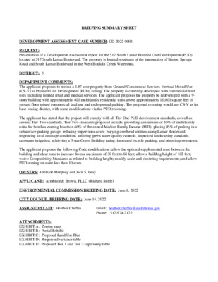
BRIEFING SUMMARY SHEET DEVELOPMENT ASSESSMENT CASE NUMBER: CD-2022-0001 REQUEST: Presentation of a Development Assessment report for the 517 South Lamar Planned Unit Development (PUD) located at 517 South Lamar Boulevard. The property is located southeast of the intersection of Barton Springs Road and South Lamar Boulevard in the West Bouldin Creek Watershed. DISTRICT: 5 DEPARTMENT COMMENTS: The applicant proposes to rezone a 1.87 acre property from General Commercial Services-Vertical Mixed Use (CS-V) to Planned Unit Development (PUD) zoning. The property is currently developed with commercial land uses including limited retail and medical services. The applicant proposes the property be redeveloped with a 9- story building with approximately 400 multifamily residential units above approximately 10,000 square feet of ground floor mixed commercial land use and underground parking. The proposed rezoning would use CS-V as its base zoning district, with some modifications via the PUD rezoning. The applicant has stated that the project will comply with all Tier One PUD development standards, as well as several Tier Two standards. Tier Two standards proposed include: providing a minimum of 10% of multifamily units for families earning less than 60% of the annual Median Family Income (MFI), placing 95% of parking in a subsurface parking garage, reducing impervious cover, burying overhead utilities along Lamar Boulevard, improving local drainage conditions, utilizing green water quality controls, improved landscaping standards, rainwater irrigation, achieving a 3-star Green Building rating, increased bicycle parking, and other improvements. The applicant proposes the following Code modifications: allow the optional supplemental zone between the building and clear zone to increase from a maximum of 30 feet to 68 feet; allow a building height of 102 feet; waive Compatibility Standards as related to building height; modify scale and clustering requirements; and allow PUD zoning on a site less than 10 acres. OWNERS: Adelaide Murphey and Jack S. Gray APPLICANT: Armbrust & Brown, PLLC (Richard Suttle) ENVIRONMENTAL COMMISSION BRIEFING DATE: June 1, 2022 CITY COUNCIL BRIEFING DATE: June 14, 2022 ASSIGNED STAFF: Heather Chaffin ATTACHMENTS: EXHIBIT A: Zoning map EXHIBIT B: Aerial Exhibit EXHIBIT C: Proposed Land Use Plan EXHIBIT D: Requested variance table EXHIBIT E: Proposed Tier 1 and Tier 2 superiority table Email: heather.chaffin@austintexas.gov Phone: 512-974-2122 P T O O M E Y R D CS-1 CS PUD P W RIVERSIDE DR P-NP CS MF-6-CO CS SF-3 SF-3-H N L N M E G H A SF-3 VIR GINIA A V E SF-3 E Y AV SF-3 SF-3 E N KIN SF-3 CS CS-1 MF-6-CO LR HIL L M O N T S T B V L D N R B A M A S L PUD CS CS-H CS-1 R N D O T R A E B LE P B U TLE T SIE S S JE CS CS-V R R D T E S HIN P E S JO CS-V B V L D S R B A M A S L CS-V CS-1-V CS-V CS-1-V CS-V CS-1 CS-V CS MF-5 CS-1-NP P-NP CS CS-1-V-NP CS-1-V-NP MF-3-NP SF-3-NP BARTON SPRINGS RD CS-V-NP E V DIN A DA NIEL D R MF-3-NP L U O B SF-3-NP P O S T O A K ST SF-3-NP MF-3-NP SF-3-NP T D S R S 3 SF-3-NP D R N O S W A D R ETA M A ST SF-3-NP EB O N Y ST SF-3-NP SF-3-H-NP SF-3-H-NP SF-3-NP MF-3-NP RA M O NA ST SF-3-NP SF-3-NP MF-2-NP H C SF-3-H-NP T H S T S 5 RISTO P H E R ST SF-3-NP C O LU M B U S S T SF-3-NP C H RISTO P H E R ST SF-3-NP SF-6-CO-NP GR-MU-CO-NP SF-3 SF-3 CS BLUFF ST CS-V T EL S H T E SF-3 T SIE S S JE SF-3 CS JULIE SF-3 T S T SF-3 CS MF-6-CO P-NP SF-3-NP SF-3 SF-3 T E S HIN P E S O J T R E A D W ELL S T CS-V MF-6-CO CS GR-V CS-V CS-V D LV R B A M A S L CS SF-3 T H S T S 8 SF-3 CS-1-V CS-1-V-CO CS CS-V CS-MU-V-CO CS T H S T S 7 TR E A D W P-NP P-NP ELL S T T H S T S 6 CS ± SUBJECT TRACT ZONING BOUNDARY DEVELOPMENT ASSESSMENT CASE#: CD-2022-0001 This product is for informational purposes and may not have been prepared for or be suitable for legal, engineering, or surveying purposes. It does not represent an on-the-ground survey and represents only the approximate relative location of property boundaries. 1 " = 400 ' This product has been produced by the Housing and Planning Department for the sole purpose of geographic reference. No warranty is made by the City of Austin regarding specific accuracy or CS C14-2008-0060 H22 V. N O C T SIE S CS-1 S JE CS-V C14-2008-0060 O F C. CS T. S E R 5 8 5-1 P-8 S C14-2008-0060 CS-V GAS CS-1-V G KIN R A P P 89-0039 C14-2008-0060 GOLF COURSE CS-V FAST FOOD R D N O T R A B E E L CS-1-V C14-2008-0060 CS-V C14-2008-0060 D V L R B A M A S L FAST FOOD 58-084 50-113 MINI-GOLF CS OFC. SUPPLY MUSICAL INSTRUMENTS OFC. APTS CS C14-68-274 P81-053 ( ( HIL L M ( ( ( ( ( O N T S T ( ( ( ( ( MF-5 ( ( ( ( SF-3 ( ( ( ( JO SEP HIN E ST ( ( ( ( ( ( ( SF-3 ( ( ( JU LIE SF-3 T S ( T ( CS C14-2008-0060 ( CS ( ( P-98-0469 S C ( ( SF-3 ( BLUFF ST A U T O ( GLASS SH O P MF-6-CO C14-00-2234 C14-2011-0153 CS-V ( ( ( ( S E L A S C14-2008-0060 CS O T U A CD-2022-0001 H21 SP95-02185CS W H S E/O F C. C14-2008-0060 CS-V PA R KIN G REST. SUPPLY ( OFC. OFC. B E A U SP95-0285CS TY S H O P ( A U NTIQ RESTAU E S 87-162 S RANT P-03-0095 C C14-2011-0047 C14-2017-0026 C14-02-0031 NPA-2017-0013.01 P RIVATE CLU B SF-3-NP C14P-72-061 P-NP P-NP ART CENTER BARTON SPRINGS RD CS-1-V-NP C14-2007-0220 C14P-84-108 C14-2007-0220 ( SP-06-0440C MF-3-NP APTS. NPA-2013-0013.01 ( ( ( D R N O S W A D ( ( ( SF-3-NP ( ( ( ( SF-3-NP ( R ( M ETA ( A ST ( ( SF-3-NP ( ( ± 1 " = 200 ' SUBJECT TRACT ZONING BOUNDARY ! ! ! ! ! ! PENDING CASE CREEK BUFFER 517 S Lamar Boulevard CASE#: LOCATION: SUBJECT AREA: GRID: MANAGER: CD-2022-0001 517 S Lamar Blvd 1.87 Acres H21 Heather Chaffin This product has been produced by the Housing and Planning Department for the sole purpose of geographic reference. No warranty is made by the City of Austin regarding specific accuracy or completeness. Created: 5/24/2022 200' S ETB A C CS K - 50' M A X H EIG H T 3 0 0 ' S E T B A C K - 6 0 ' M A X H E I G H T BARTON SPRING ROAD (R.O.W. VARIES) 4 0 0 ' S E T B A C K - 8 5 ' M A X H E I G H T CS-V CS-V 1.87 ACRES T H EIG X H A 0' M K - 6 C A B T E 0' S 0 3 CS-V USE: COMMERICAL ZONING MAX HT: 60 FT CS-V CS-V UNION PACIFIC RAILROAD MF-3-NP T H EIG X H A 0' M K - 5 C A B T E 0' S 0 2 MF-3-NP T H EIG X H A 0' M K - 4 P-NP C A B T E 0' S 0 1 100' S ETB A C K - 40' M A X H EIG H T MF-5 SF-3 CS SF-3 SF-3 SF-3 CS SF-3 D R A S) V RIE E L U A O H V R B A M A H L T U O S (R.O.W. WID T LEGEND BARTON SPRINGS SCENIC ROADWAY OVERLAY COMPATIBILITY SETBACKS EASEMENT PROPERTY LINE SUBJECT PROPERTY LINE 100 YEAR FLOODPLAIN CRITICAL WATER QUALITY ZONE MF-3-NP 2 9 5 2 - 8 9 2 ) 2 1 5 ( x a F 4 8 2 3 - 8 9 2 ) 2 1 5 ( . l e T 2 2 0 2 t h g i r y p o C © C L L , C M E a z r a G 9 2 6 4 1 - F # E P B T 5 2 1 e t i u S , . l d v B o t l i a R 8 0 7 7 5 3 7 8 7 s a x e T , n i t s u A I I S N O T D N O C G N T S X E I I R A M A L H T U O S 7 1 5 S A X E T , I N T S U A , R A M A L H T U O S 7 1 5 5 2 0 0 0 - 1 3 2 1 0 1 : . O N T C E J O R P 3 : Y B D E N G S E D I : Y B N W A R D : C Q / A Q SHEET 1 i M P 0 4 : 4 2 2 , 6 2 n a J n o r e h c s d k y b d e i f i d o m g w d . D N O C X E - 5 2 0 0 0 - 1 3 2 1 0 1 \ S T B H X E D U P S T B H X E D A C - 0 0 \ l i - I I I \ I \ i \ v C 5 2 0 0 0 - 1 3 2 1 0 1 \ : V CS BARTON SPRING ROAD (R.O.W. VARIES) SUBMITTAL DATE : JANUARY 27TH, 2022 CS-V CS-V MF-5 SF-3 CS SF-3 SF-3 SF-3 CS SF-3 D R A S) V RIE E L U A O H V R B A M A H L T U O S (R.O.W. WID T PUD USE: MIXED USE ZONING MAX HT: 102 FT CS-V UNION PACIFIC RAILROAD P-NP MF-3-NP MF-3-NP 2 9 5 2 - 8 9 2 ) 2 1 5 ( x a F 4 8 2 3 - 8 9 2 ) 2 1 5 ( . l e T 2 2 0 2 t h g i r y p o C © C L L , C M E a z r a G 9 2 6 4 1 - F # E P B T 5 2 1 e t i u S , . l d v B o t l i a R 8 0 7 7 5 3 7 8 7 s a x e T , n i t s u A E S U D N A L R A M A L H T U O S 7 1 5 S A X E T , I N T S U A , R A M A L H T U O S 7 1 5 5 2 0 0 0 - 1 3 2 1 0 1 : . O N T C E J O R P 3 : Y B D E N G S E D I : Y B N W A R D : C Q / A Q SHEET 2 l - M A 7 4 : 1 1 2 2 , 8 2 n a J n o a r b a e d p y b d e i f i d o m g w d . E S U D N A L - 5 2 0 0 0 - 1 3 2 1 0 1 \ S T B H X E D U P S T B H X E D A C - 0 0 \ l i I \ I I I \ i \ v C 5 2 0 0 0 - 1 3 2 1 0 1 \ : V 2 9 5 2 - 8 9 2 ) 2 1 5 ( x a F 4 8 2 3 - 8 9 2 ) 2 1 5 ( . l e T 2 2 0 2 t h g i r y p o C © C L L , C M E a z r a G 9 2 6 4 1 - F # E P B T 5 2 1 e t i u S , . l d v B o t l i a R 8 0 7 7 5 3 7 8 7 s a x e T , n i t s u A S E T O N E S U D N A L R A M A L H T U O S 7 1 5 S A X E T , I N T S U A , R A M A L H T U O S 7 1 5 5 2 0 0 0 - 1 3 2 1 0 1 : . O N T C E J O R P 3 : Y B D E N G S E D I : Y B N W A R D : C Q / A Q SHEET 3 l M P 2 3 : 4 2 2 , 8 2 n a J n o a r b a e d p y b d e i f i d o m g w d . E T O N - 5 2 0 0 0 - 1 3 2 1 0 1 \ S T B H X E D U P S T B H X E D A C - 0 0 \ l i I \ I \ I I i \ v C 5 2 0 0 0 - 1 3 2 1 0 1 \ : V 517 SOUTH LAMAR PLANNED UNIT DEVELOPMENT CODE MODIFICATION TABLE CODE REFERENCE Section 25-2-144(D) Chapter 25-2, Subchapter B, Article 2, Division 5, Section 2.3.1(L) CURRENT CODE LANGUAGE PROPOSED PUD LANGUAGE/CODE MODIFICATION REASON FOR CODE MODIFICATION 25-2-144(D): A PUD District Must include at least 10 acres of land, unless the property is characterized by special circumstances, including unique topographic constraints. Section 25-2-144(D) and Section 25-2, Subchapter B, Article 2, Division 5, Section 2.3.1(L) is modified to allow the PUD to include less than 10 acres of land. 25-2, Subchapter B, Article 2, Division 5, Section 2.3.1(L): All PUDs must include at least 10 acres of land, unless the property is characterized by special circumstances, including unique topographic constraints. The Property is approximately 1.87 acres. The PUD proposes a mixed use project with approximately 399 multi-family residential units and retail/restaurant uses at the ground level. PUD zoning is the only zoning district under current code that allows for a mixed use project to exceed a maximum height of 60-ft. Chapter 25-2, Subchapter E, Section 2.2.2.C.1 If a supplemental zone is provided, up to 30 percent of the linear frontage of the supplemental zone may be a maximum of 30-ft wide, and the remainder of the supplemental zone shall be a maximum of 20-ft wide. Chapter 25-2, Subchapter E, Section 2.2.2.C.1 is modified to allow the supplemental zone to be a maximum depth of 68 feet. The code modification is requested to allow for patio space to be located at the northwest corner of the site along a portion of South Lamar Boulevard. Section 25-2-1063(C) (C) The height limitations for a structure are: (1) two stories and 30 feet, if the structure is 50 feet or less from property: (a) in an SF-5 or more restrictive zoning district; or (b)on which a use permitted in an SF-5 or more restrictive zoning district is located; or Section 25-2-1063(C) is modified such that the height and setback limitations shall not apply to the property. (2) three stories and 40 feet, if the structure is more than 50 feet and not more than 100 feet from property: (a)in an SF-5 or more restrictive zoning district; or (b)on which a use permitted in an SF-5 or more restrictive zoning district is located; (3) for a structure more than 100 feet but not more than 300 feet from property zoned SF- 5 or more restrictive, 40 feet plus one foot for each 10 feet of distance in excess of 100 feet from the property zoned SF-5 or more restrictive; or (4) for a structure more than 300 feet but not more than 540 feet from property zoned SF- 5 or more restrictive, 60 feet plus one foot for each four feet of distance in excess of 300 The proposed building height is 102-ft. Compatibility is triggered by an SF- 3 zoned property to the east of the site and located at 700 Dawson Road. The eastern triggering property is currently classified as a club/lodge use and is occupied by High Road which is a member based non-profit charity organization. Compatibility is also triggered by the single-family homes located to the west of the site accross South Lamar Boulevard which is classified as a Core Transit Corridor. The closest SF-3 property is located approximately ±158 feet from the site. The SF-3 lots are elevated approximately 38-ft above the proposed finished floor elevation of the site. The purpose of compatibility is to prevent buildings from towering over adjoining single family lots. Given the site's proximity and intervening roadway bisecting the SF-3 lots to the west, the proposed development meets the intent of the Compatibility Standards. Furthermore, if approved the additional height proposed as part of the PUD will provide more affordable housing units to help meet the City of Austin's 10 year affordability goals established by the Austin Strategic Housing Blueprint. Section 25-2-1065 Section 25-2-1065 (Scale and Clustering Requirements ) shall not apply to the PUD. The PUD proposes one building to be located on the property. In order to provide additional affordable units as noted above, we are requesting to modify this code section to allow for increased density on the site. (A) The massing of buildings and the appropriate scale relationship of a building to another building may be accomplished by: (1) avoiding the use of a continuous or unbroken wall plane; (2) using an architectural feature or element that: (a) creates a variety of scale relationships; (b) creates the appearance or feeling of a residential scale; or (c) is sympathetic to a structure on an adjoining property; or (3) using material consistently throughout a project and that is human in scale; or (4) using a design technique or element that: (a) creates a human scale appropriate for a residential use; or (b) prevents the construction of a structure in close proximity to a single-family residence zoning district that is: (i) significantly more massive than a structure in a single-family residence zoning district; or (ii) antithetical to an appropriate human scale; and (c) allows the construction of a structure, including a multi-family structure, that exhibits a human scale and massing that is appropriate for a residential use. (B) Except for good cause, the first tier of buildings in a multi-family or mixed use project must be clustered in a group that is not more than 50 feet wide, as measured along the side of the buildings that are most parallel to the property line of the site. (C) The depth of the first tier of buildings described under Subsection (B) may not exceed: (1) two units; or (2) 60 feet. (D) A building must be at least 10 feet apart from another building, as measured from wall face to wall face. (E) Subsections (B), (C), and (D) do not apply to a: (1)private or public primary educational facility; (2)private or public secondary educational facility; or (3)a college or university. (F) In Subsection (B), good cause may be shown by compliance with Subsection (A). Section 25-7-92 (Encroachment on Floodplain Prohibited) Development in the 25-year and 100-year floodplain is allowed per Section 25-7-92(C), except that compensation of the floodplain volume displaced by the development shall not be required. The property is currently developed with almost 100% impervious cover with such improvements located within the existing floodplain. The PUD proposes to enhance the existing conditions by making necessary drainage improvements to help compensate for the proposed development. The project proposes to allow the building columns to be located within the 100-year floodplain located in the northwest corner of the property. The project also proposes to provide a supplemental zone that will include pavers and outdoor seating within the floodplain area. The improvements proposed by the PUD will not create a situation that adversly impacts the existing conditions. Furthermore as part of the PUD areas within the floodplain will be restored in accordance with the Environmental Criteria Manual. (A) Except as provided in Section 25-7-96 (Exceptions in the 25-Year Floodplain), a development application may not be approved if a proposed building or parking area encroaches on the 25-year floodplain. (B) Except as provided in Sections 25-7-93 (General Exceptions), 25-7-94 (Exceptions in Central Business Area), and 25-7-95 (Exceptions for Parking Areas), a development application may not be approved if a proposed building or parking area encroaches on the 100-year flood plain. (C) The director may grant a variance to Subsection (A) or (B) if the director determines that: (1) the finished floor elevation of a proposed building is at least two feet above the 100-year floodplain; (2) normal access to a proposed building is by direct connection with an area above the regulatory flood datum, as prescribed by Chapter 25-12, Article 1 (Building Code); (3) a proposed building complies with the requirements in Chapter 25-12, Article 3 (Flood Hazard Areas); (4) the development compensates for the floodplain volume displaced by the development; (5) the development improves the drainage system by exceeding the requirements of Section 25-7-61 (Criteria for Approval of Development Applications), as demonstrated by a report provided by the applicant and certified by an engineer registered in Texas; (6) the variance is required by unique site conditions; and (7) development permitted by the variance does not result in additional adverse flooding impact on other property. (D)The director shall prepare written findings to support the grant or denial of a variance request under this section. Section 25-8-261 (Critical Water Quality Zone Restrictions) Critical Water Quality Zone Restrictions Section 25-2-261 is modified to allow for the following improvements within the Critical Water Quality Zone: patio pavers, outdoor seating areas, building columns, streetscape improvements, storm infrastructure, and below grade parking structures. The area within the CWQZ is currently developed with surface parking and impervious surfaces. This code modification is requested to allow for the various improvements to be located within the CWQZ. It should be noted that a minimum of 750 square feet of impervious cover currently within the critical will be removed and restored with various plantings and vegetation. Section 25-8-281(C)(2) (Critical Environmental Features) Within a buffer zone described in this subsection: (a) the natural vegetative cover must be retained to the maximum extent practicable; (b) construction is prohibited; and (c) wastewater disposal or irrigation is prohibited. Section 25-8-281(C )(2) is modified to allow for the following improvements within the CEF buffer zone: drainage/storm infrastructure, access drives, water quality infrastucture. The code modification is requested to allow for improvements to be located within the CEF buffer zone established by a rimrock CEF located offsite to the east of the property across the rail road tracks. Tier One Requirement Meet the objectives of the City Code Provide for development standards that achieve equal or greater consistency with the goals in Section 1.1 (General Intent) than development under the regulations in the Land Development Code. Section 1.1 states that "[t]his division provides the procedures and minimum requirements for a planned unit development zoning district to implement the goals of preserving the natural environment, encouraging high quality development and innovative design, and ensuring adequate public facilities and services." Provide a total amount of open space that equals or exceeds 10 percent of the residential tracts, 15 percent of the industrial tracts, and 20 percent of the nonresidential tracts within the PUD, except that: 1.a detention or filtration area is excluded from the calculation unless it is designed and maintained as an amenity; and 2. the required percentage of open space may be reduced for urban property with characteristics that make open space infeasible if other community benefits are provided. Comply with the City's Planned Unit Development Green Building Program Be consistent with applicable neighborhood plans, neighborhood combining district regulations, historic area and landmark regulations, and compatible with adjacent property and land uses Open Space Green Building Neighborhood Plans, Historic Areas, Compatibility Environmental Preservation Public Facilities Provide for environmental preservation and protection relating to air quality, water quality, trees, buffer zones and greenbelt areas, critical environmental features, soils, waterways, topography, and the natural and traditional character of the land. Provide for public facilities and services that are adequate to support the proposed development including school, fire protection, emergency service, and police facilities. Exceed the minimum landscaping requirements of the City Code. Landscaping Transportation, Connectivity Provide for appropriate transportation and mass transit connections to areas adjacent to the PUD district and Prohibit Gated Roadways Historical Preservation PUD Size Commercial Design Standards Open Space mitigation of adverse cumulative transportation impacts with sidewalks, trails, and roadways. Prohibit gated roadways Protect, enhance, and preserve areas that include structures or sites that are of architectural, historical, archaeological, or cultural significance Include at least 10 acres of land, unless the property is characterized by special circumstances, including unique topographic constraints Comply with Chapter 25-2, Subchapter E (Design Standards and Mixed Use) Inside the urban roadway boundary depicted in Figure 2, Subchapter E, Chapter 25-2 (Design Standards and Mixed Use), comply with the sidewalk standards in Section 2.2.2., (Core Transit Corridors: Sidewalks And Building Placement) Contain pedestrian-oriented uses as defined in Section 25-2-691(C) (Waterfront Overlay District Uses) on the first floor of a multi-story commercial or mixed use building. Tier Two Requirement Provides open space at least 10% above the requirements of Section 2.3.1.A. ( Minimum Requirements ). Alternatively, within the urban roadway boundary established in Figure 2 of Subchapter E of Chapter 25-2 (Design Standards and Mixed Use), provide for proportional enhancements to existing or planned trails, parks, or other recreational common open space in consultation with the Director of the Parks and Recreation Department. Required: Equals or exceeds 10 percent of the residential tracts, 15 percent of the industrial tracts, and 20 percent of the nonresidential tracts within the PUD 517 South Lamar PUD Tier 1 & Tier 2 Superiority Table Superior The PUD meets the objectives of City Code. The PUD encourages high quality development, innovative design, and encourages the provision of adequate public facilities and services. The PUD will include 0.302 acres of open space (10.9%) which will consist of a publically accessible patio space along South Lamar Boulevard, a private courtyard space for residents,and a rooftop amenity deck. The publically accessible patio space will include outdoor seating. The PUD will achieve a 3-Star Austin Energy Green Building rating. The Property is not located within an adopted neighborhood planning area. The PUD proposes a 399-multi-family project with ground level retail/restaurant uses which is consistent with the surrounding land uses which include a mixture of multi-family uses, office uses, commercial uses, restaurant uses, and single-family residences which are situated at a higher elevation on the bluff across South Lamar Boulevard. The existing development currently does not provide any on-site water quality. The proposed development will improve off-site drainage conditions in the area and provide additional water quality in order to preserve and protect the character of the land. The public facilities and services in the area are adequate to support the proposed development. Adequate access to the site will be provided for emergency services and fire protection. The PUD will exceed the minimum landscaping requirements of the City Code. The PUD will enhance the pedestrian realm by providing sidewalk and streetscape improvments consistent with what is proposed under the South Lamar Boulevard Corridor Mobility Plan. The PUD will not include any gated public right-of-ways. There are no existing structures on the Property that are of architectural, historical, archaelogical, or cultural significance. The Property is approximately 1.87 acres. The PUD proposes a mixed-use project with approximately 399 multi-family residential units and restaurant/retail uses at the ground level. There are currently no zoning districts under current code that allow for a mixed use project to exceed 60-ft in height except for PUD zoning. The PUD will comply with Subchapter E of the City's Land Development Code, except as modified by the PUD. The Street Section for South Lamar Boulevard will be enhanced to meet the intent of the South Lamar Corridor Mobility Plan. We are currently coordinating with ATD and the Corridor Program Office to determine the cross section that will be required along South Lamar Boulevard in accordance with the South Lamar Corridor Mobility Plan. The PUD will incorporate pedestrian-oriented uses as defined in Section 25-2-691(C) on the ground floor of the building. Superior Environment/Drainage Complies with current code instead of asserting entitlement to follow older code provisions by application of law or agreement. Provides water quality controls superior to those otherwise required by code. The PUD will comply with current code except where as modified by the PUD. Uses green water quality controls as described in the Environmental Criteria Manual to treat at least 50 percent of the water quality volume required by code. Provides water quality treatment for currently untreated, developed off-site areas of at least 10 acres in size. Reduces impervious cover by five percent below the maximum otherwise allowed by code or includes off-site measures that lower overall impervious cover within the same watershed by five percent below that allowed by code. Provides minimum 50-foot setback for at least 50 percent of all unclassified waterways with a drainage area of 32 acres. Provides volumetric flood detention as described in the Drainage Criteria Manual. Provides drainage upgrades to off-site drainage infrastructure that does not meet current criteria in the Drainage or Environmental Criteria Manuals, such as storm drains and culverts that provide a public benefit. Proposes no modifications to the existing 100-year floodplain. Uses natural channel design techniques as described in the Drainage Criteria Manual. Restores riparian vegetation in existing, degraded Critical Water Quality Zone areas. A minimum of 8,100 cubic feet of water quality volume will be provided through onsite water quality controls. In addition, a minimum of 50% of the required water quality volume for the site will be provided using green water quality controls. The PUD proposes to utilize green water quality controls as described in Section 1.6.7 of the Environmental Criteria Manual to treat a minimum of 50% of the water quality volume required by code. The base zoning district for the PUD is CS-V which allows for a maximum of 95% impervious cover on the site. Under existing conditions, the property is comprised of 99.67% impervious cover. The PUD will reduce the maximum impervious cover and building coverage allowed on the site to 90% which is a 9.67% reduction in impervious cover. Not Applicable. There are no unclassified waterways on the property. Detention is not proposed due to the overall reduction of impervious cover on the site. Due to the off-site drainage improvements being undersized, under existing conditions water sheet flows through the site and enters the right-of-way of South Lamar Boulevard before entering into an inlet on South Lamar. The PUD proposes to improve the off-site drainage conditions throughout the area by constructing a box culvert to collect and capture storm runoff at the southern property line and reroute flows along the eastern and northern property line before connecting to the existing system downstream. Not applicable. Proposed drainage will be captured and conveyed via a box culvert along the eastern and northern property lines. No channels are proposed onsite. Approximately 5,042 square feet (0.11 acres) of the property is currently located within the Critical Water Quality Zone ("CWQZ") with 100% of the area developed as a surface parking lot. The PUD proposes to remove a minimum of 750 square feet of impervious cover within the CWQZ and restore the area with plantings and riparian vegetation. Removes existing impervious cover from the Critical Water Quality Zone. Preserves all heritage trees; preserves 75% of the caliper inches associated with native protected size trees; and preserves 75% of all of the native caliper inches. Tree plantings use Central Texas seed stock native and with adequate soil volume. The PUD proposes to remove a minimum of 750 square feet of impervious cover within the CWQZ. Not applicable. There are no existing trees located on-site. All required tree plantings shall utilize native tree species selected from Appendix F of the Environmental Criteria Manual Appendix (Descriptive Categories of Tree Species) and utilize central texas native seed stock. Additionally, all street trees shall be a minimum of 3 caliper inches. The PUD will provide at least 1,000 cubic feet of soil volume per tree for the required inches of street trees within the PUD. Up to 25% of the soil volume may be shared and adjusted for trees in continuous plantings. Load-bearing soil cells shall be used to meet the soil volume requirement if necessary. The City Arborist may reduce the minimum soil volume requirement if necessary due to utility conflicts or other contractability issues. Austin Energy Green Building Provides an Austin Energy Green Building Rating of three stars or above. The PUD will achieve a 3-Star Austin Energy Green Building rating. Provides at least a 50 percent increase in the minimum waterway and/or critical environmental feature setbacks required by code. Clusters impervious cover and disturbed areas in a manner that preserves the most environmentally sensitive areas of the site that are not otherwise protected. Provides porous pavement for at least 20 percent or more of all paved areas for non-pedestrian in non-aquifer recharge areas. Provides porous pavement for at least 50 percent or more of all paved areas limited to pedestrian use. Provides rainwater harvesting for landscape irrigation to serve not less than 50% of the landscaped areas. Directs stormwater runoff from impervious surfaces to a landscaped area at least equal to the total required landscape area. Employs other creative or innovative measures to provide environmental protection. Art Great Streets Community Amenities Provides art approved by the Art in Public Places Program in open spaces, either by providing the art directly or by making a contribution to the City's Art in Public Places Program or a successor program. Complies with City's Great Streets Program, or a successor program. Applicable only to commercial, retail, or mixed-use development that is not subject to the requirements of Chapter 25-2, Subchapter E (Design Standards and Mixed Use ). Provides community or public amenities, which may include spaces for community meetings, community gardens or urban farms, day care facilities, non-profit organizations, or other uses that fulfill an identified community need. Transportation Provides publicly accessible multi-use trail and greenway along creek or waterway. Provides bicycle facilities that connect to existing or planned bicycle routes or provides other multi-modal transportation features not required by code. Building Design Parking Structure Frontage Affordable Housing Exceeds the minimum points required by the Building Design Options of Section 3.3.2. of Chapter 25-2, Subchapter E (Design Standards and Mixed Use). In a commercial or mixed-use development, at least 75 percent of the building frontage of all parking structures is designed for pedestrian-oriented uses as defined in Section 25-2-691(C) (Waterfront Overlay District Uses) in ground floor spaces. Provides for affordable housing or participation in programs to achieve affordable housing. 100% of all landscaping on-site will be irrigated by either stormwater run-off conveyed to rain gardens, collection of air condition condensate, or through the use of rainwater harvesting (or through a combination of the above); provided however that the applicant shall have the right to supplement such landscape irrigation with potable water if necessary. The PUD will provide an Integrated Pest Management Plan at the time of site plan following the guidelines of the City of Austin Grow Green Program. Street yard landscaping will exceed the minimum requirements by an additional 15% for a total of 35%. 100% of all non-turf landscape plant materials shall be selected from either the Environmental Criteria Manual Appendix N (City of Austin Preferred Plant List ), the "Grow Green Native and Adaptive Plants Guide", and/or the City of Austin Rain Garden Plant List. The PUD shall participate in the Art in Public Places program either by locating art within the property or by making a financial contribution to the City of Austin. The PUD will comply with the requirements of Chapter 25-2, Subchapter E (Design Standards and Mixed Use) except where as modified by the PUD. Additionally, we are coordinating with the Corridor Program Office to determine the required cross-section for streetscape improvements in accordance with the South Lamar Boulevard Corridor Mobility Plan. Not Applicable. There are no creeks or waterways located on the property. The PUD will provide bicycle parking for patrons of the project at a level equal to or exceeding the greater of (1) 120% of code required bicycle parking spaces or (2) 10 bicycle parking spaces. All bicycle parking will be located within the structured parking garage and/or within the planting or supplemental zone along South Lamar Boulevard. A minimum of 50% of the required parking will be located within the planting or supplemental zone. Additionally, a bike locker will be provided for residents of the development. The PUD will provide direct access to the shared use path proposed by the South Lamar Corridor Mobility Plan to allow for multi-modal transportation to and from the site. Bicycle facilities along South Lamar Boulevard will be reviewed at the time of site plan and construction shall be required in accordance with the South Lamar Boulevard Corridor Mobility Plan. The PUD will achieve a minimum of nine (9) points under the Building Design Options of Section 3.3.2 of Chapter 25-2, Subchapter E (Design Standards and Mixed Use) A minimum of 95% of the required parking will be provided in a below grade parking structure in order to allow a minimum of 75% of the building frontage along South Lamar Boulevard to be designated for pedestrian-oriented uses at the ground level. No more than 5% of the required parking will be provided at grade. The Austin Strategic Housing Blueprint (the "ASHP") was adopted by City Council in 2017 to address the City's affodable housing challenges. As part of the ASHP, the City established a 10-year goal of providing approximately 135,000 housing units within the City of Austin. Of the 135,000 housing units, 60,000 of those housing units are to be for households earning no more than 80% of the median family income (MFI). Additionally, the ASHP provides that at least 75% of the new housing units are to be located within 1/2 mile of an Imagine Austin Center and Corridor and 90% of newly built or preserved affordable housing to be located within 3/4 of a mile of transit service. To help meet this goal the City Council identified specific affordable housing goals within each Council District and along transit corridors. This PUD is located within Council District No. 5 which has a goal of providing approximately 4,473 units at or below 80% MFI. In an effort to help meet the goals established by the City in the ASHP, the PUD will meet the affordability requirements established in VMU Ordinance No. 20081016-049 by reserving a minimum of 10% of the overall proposed rental units on the Property as affordable for households earning no more than 60% of the Annual Median Family Income. This is far superior to the requirements outlined in Section 2.5 (Development Bonus ) requirements. By providing affordable housing in accordance with the VMU requirements, this project has the potential to provide up to 40 affordable units based on the overall proposed units. Historic Preservation Preserves historic structures, landmarks, or other features to a degree exceeding applicable legal requirements. Not Applicable. There are no historic structures or landmarks located on the property. Accessibility Provides for accessibility for persons with disabilities to a degree exceeding applicable legal requirements. Provides space at affordable rates to one or more independent retail or restaurant small businesses whose principal place of business is within the Austin metropolitan statistical area. Local Small Business Project Specific Superiority Items - Utilities Project Specific Superiority Items - EV Charging Stations All above grade utilities along the property's frontage will be buried underground in order to enhance the pedestrian realm at the ground level. The PUD will provide two Electric Vehicle charging stations within the parking garage. The Electric Vehicle charging stations will be available for use by residents, tenants, and patrons of the retail space.