PLANNING COMMISSION RECOMMENDATION 20221115-19 Date: November 15, 2022 Subject: Code Amendment - Compatibility and Parking Requirements along Certain Roadways. Seconded By: Commissioner Azhar Motioned By: Commissioner Thompson Recommendation Recommend an ordinance amending City Code Title 25 to create a new overlay that modifies compatibility and parking requirements along certain roadways and include the following amendments: 1. § 25-2-769.04 (D), Strike out "two stories" and "three stories" in this section and remove the reference to stories from all other parts of the ordinance. To read as follows: “The height limitation for a structure is: (1) two stories and 35 feet, if the structure is 50 feet or less from a triggering property; (2) three stories and 45 feet, if the structure is more than 50 feet and not more than 100 feet from a triggering property; or” 2. § 25-2-769.06 (F), Fee in lieu funds must be used within 0.25 miles of a corridor. 3. § 25-2-769.06 (F) (2) and (3), and § 25-2-769.04 (B) (2), Allow the same compatibility standards on both light rail and large corridors. This standard should be the following: - a structure can reach allowable height if the structure is located at least 100 feet from a triggering property if it is participating in an affordable housing program. - a structure can reach allowable height if the structure is located at least 200 feet from a triggering property if it is not participating in an affordable housing program. 4. § 25-2-769.06 (F) (4), and § 25-2-769.04 (B) (2), The compatibility standards for medium corridors should be the following: - a structure can reach a maximum height of 65 ft if the structure is located at least 100 feet from a triggering property if it is participating in an affordable housing program. - a structure can reach a maximum height of 85 ft if the structure is located at least 150 feet from a triggering property if it is participating in an affordable housing program. - a structure can reach the allowable height if the structure is located at least 200 feet from a triggering property, whether it is participating in an affordable housing program or not. 1 of 2 5. § 25-2-769.04 (C), Define what is or is not allowed in the 25 foot compatibility setback. We should ensure that refuse uses such as dumpsters are not allowed and buildings, meaning covered spaces which a human …
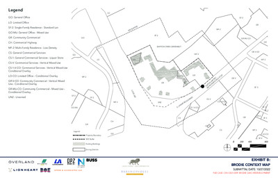
Legend GO: General Office LO: Limited Office SF-2: Single-Family Residence - Standard Lot GO-MU: General Office - Mixed Use GR: Community Commercial CH: Commercial Highway GO MF-2: Multi-Family Residence - Low Density CS: General Commercial Services CS-1: General Commercial Services - Liquor Store CS-V: Commercial Services - Vertical Mixed Use GO CS-1-V-CO: Commercial Services - Vertical Mixed Use Conditional Overlay LO-CO: Limited Office - Conditional Overlay MF-2 GR-V-CO: Community Commercial - Vertical Mixed Use - Conditional Overlay GR-MU-CO: Community Commercial - Mixed Use - Conditional Overlay UNZ - Unzoned SF-2 SF-2 GO-MU LO R E F F U 0 ’ B 0 5 SF-2 LO CS BARTON CREEK GREENBELT MF-4 L O O P 3 6 0 MF-2 UNZ CS-1-V-CO CS-1 GR GR CS U S S T O P O E T R R A PID B GR-V A PIT A L M E T R O M C CS-V D R A V E L U O R B A CS-1-V-CO M A S . L CS CH GO GR Legend: Property Boundary 500’ Buffer Existing Buildings Zoning Districts MF-2 SF-2 GR GR-MU-CO GR-V-CO GR MF-2 SF-3 SF-5 SF-3 GR SF-6 SF-3 CS-1-V CS CS MF-2 LO-CO SF-6 0 200 400 800 EXHIBIT B: BRODIE CONTEXT MAP SUBMITTAL DATE: 10/27/2022 PUD CASE: C814-2021-0099 BRODIE OAKS REDEVELOPMENT SITE METRICS 37.6 Acres / 1,637,856 Sq. Ft. 56% NSA; 54% GSA 5,750 Sq. Ft. 50 feet Total Site Area Proposed Impervious Cover Minimum Lot Size Minimum Lot Width Minimum Setbacks Front Street Side Yard Interior Side Yard Rear Yard 0 feet 0 feet 0 feet 0 feet LAND USE AREA METRICS Acres Building Cover Impervious Cover* Non- Residential Maximum Hotel Maximum Residential Max. % Max. Sq. Ft. Keys Sq. Ft. Units Sq. Ft. 1,400,000 200 200,000 1,700 1,500,000 11.7 .5% 5,000 -- -- -- -- Max. 95% 25.9 Land Use Area 1 Land Use Area 2 Site Total 37.6 95% 7.5% 56% *Maximum impervious cover is based on Net Site Area (NSA) and will be tracked by site plan in compliance with Exhibit H - Brodie Oaks Redevelopment Phasing Plan. Impervious Cover will be higher on a site-by-site basis. Maximum floor-to-area ratio is not applicable to the Brodie Oaks Redevelopment. L O O P 3 6 0 BARTON CREEK GREENBELT Legend: Property Boundary Private Streets with Public Access Easements Land Use Area 1 Land Use Area 2 U S S T …
ZONING CHANGE REVIEW SHEET CASES: C814-2021-0099 – Brodie Oaks Redevelopment PUD DISTRICT: 5 C14R-81-033(RCA) – Brodie Oaks Restrictive Covenant Amendment ZONING FROM: Unzoned; GR; CS; CS-1 TO: PUD ADDRESS: 4021, 4025, 4107, 4109, 4115, and 4141 South Capital of Texas Highway Northbound; 3940, 4006, 4024 - 4040, 4200, 4220, 4236 South Lamar Boulevard Southbound SITE AREA: 37.606 acres PROPERTY OWNER: Lionstone Investments, LCFRE Austin Brodie Oaks LLC (John Schaefer) AGENT: Lionheart Places (Rebecca Leonard) CASE MANAGER: Wendy Rhoades (512-974-7719, wendy.rhoades@austintexas.gov) STAFF RECOMMENDATIONS: The Staff recommendation is to grant planned unit development (PUD) district zoning, as shown in the Land Use Plan as provided Exhibits C, D, E, F, G, H, I, J, and K. For a summary of the basis of Staff’s recommendation, see pages 3 - 14. The Restrictive Covenant includes all recommendations listed in the Transportation Impact Analysis Memo, dated August 31, 2022, as provided in Attachment A. The Staff recommendation is to grant an amendment of the 1981 Restrictive Covenant and terminate the height limitations for Tracts A1, A2, A3, A4, and B as it applies to this property. For a summary of the basis of Staff’s recommendation, see pages 3 - 14. PARKS AND RECREATION BOARD: September 26, 2022: RECOMMENDED TO THE CITY COUNCIL THE BRODIE OAKS PUD AS SUPERIOR IF THE APPLICANT AGREES TO: 1) WORK WITH STAFF AND ATD TO PROVIDE 10 FREE PARKING SPACES TO THE NEIGHBORHOOD PARK SITE; 2) AMEND THE APPLICATION TO STATE THERE WILL BE A PUBLICLY AVAILABLE RESTROOM AT THE NEIGHBORHOOD PARK; 3) CONTINUE TO WORK WITH THE HILL COUNTRY CONSERVANCY AND AUSTIN PARKS FOUNDATION TO ENSURE THIS IS A SUSTAINABLE TRAIL ACCESSING THE BARTON CREEK GREENBELT, AND 4) INVESTIGATE AND REPORT BACK ON METHODS TO FUND OFF-SITE BARTON CREEK GREENBELT PRESERVATION AND MANAGEMENT THROUGH COMMERCIAL DEVELOPMENT AT THE SITE (refer to Attachment C) [S. FAUST; N. BARNARD – 2ND] (9-0) D. LEWIS AND K. TAYLOR – ABSENT 21 of 103 ENVIRONMENTAL COMMISSION RECOMMENDATION: November 2, 2022: PLANNING COMMISSION ACTION: November 8, 2022: May 24, 2022: APPROVED AN INDEFINITE POSTPONEMENT REQUEST BY STAFF R. SCHNEIDER; J. THOMPSON – 2ND] (9-0) Y. FLORES, C. HEMPEL, J. MUSHTALER – ABSENT December 14, 2021: APPROVED AN INDEFINITE POSTPONEMENT REQUEST BY STAFF [A. AZHAR; R. SCHNEIDER – 2ND] (11-0) P. HOWARD – OFF THE DAIS; J. SHIEH – ABSENT CITY COUNCIL ACTION: December 1, 2022: ORDINANCE NUMBER: ISSUES: Austin Energy has requested that …
ZONING CHANGE REVIEW SHEET C14R-81-033(RCA) – Brodie Oaks Restrictive Covenant Amendment CASES: C814-2021-0099 – Brodie Oaks Redevelopment PUD DISTRICT: 5 ZONING FROM: Unzoned; GR; CS; CS-1 ADDRESS: 4021, 4025, 4107, 4109, 4115, and 4141 South Capital of Texas Highway Northbound; 3940, 4006, 4024 - 4040, 4200, 4220, 4236 South Lamar Boulevard Southbound SITE AREA: 37.606 acres PROPERTY OWNER: Lionstone Investments, LCFRE Austin Brodie Oaks LLC TO: PUD (John Schaefer) AGENT: Lionheart Places (Rebecca Leonard) CASE MANAGER: Wendy Rhoades (512-974-7719, wendy.rhoades@austintexas.gov) STAFF RECOMMENDATIONS: The Staff recommendation is to grant planned unit development (PUD) district zoning, as shown in the Land Use Plan as provided Exhibits C, D, E, F, G, H, I, J, and K. For a summary of the basis of Staff’s recommendation, see pages 3 - 14. The Restrictive Covenant includes all recommendations listed in the Transportation Impact Analysis Memo, dated August 31, 2022, as provided in Attachment A. The Staff recommendation is to grant an amendment of the 1981 Restrictive Covenant and terminate the height limitations for Tracts A1, A2, A3, A4, and B as it applies to this property. For a summary of the basis of Staff’s recommendation, see pages 3 - 14. PARKS AND RECREATION BOARD: September 26, 2022: RECOMMENDED TO THE CITY COUNCIL THE BRODIE OAKS PUD AS SUPERIOR IF THE APPLICANT AGREES TO: 1) WORK WITH STAFF AND ATD TO PROVIDE 10 FREE PARKING SPACES TO THE NEIGHBORHOOD PARK SITE; 2) AMEND THE APPLICATION TO STATE THERE WILL BE A PUBLICLY AVAILABLE RESTROOM AT THE NEIGHBORHOOD PARK; 3) CONTINUE TO WORK WITH THE HILL COUNTRY CONSERVANCY AND AUSTIN PARKS FOUNDATION TO ENSURE THIS IS A SUSTAINABLE TRAIL ACCESSING THE BARTON CREEK GREENBELT, AND 4) INVESTIGATE AND REPORT BACK ON METHODS TO FUND OFF-SITE BARTON CREEK GREENBELT PRESERVATION AND MANAGEMENT THROUGH COMMERCIAL DEVELOPMENT AT THE SITE (refer to Attachment C) [S. FAUST; N. BARNARD – 2ND] (9-0) D. LEWIS AND K. TAYLOR – ABSENT 31 of 103 C814-2021-0099 / C14R-81-033(RCA) Page 2 ENVIRONMENTAL COMMISSION RECOMMENDATION: November 2, 2022: PLANNING COMMISSION ACTION: November 8, 2022: May 24, 2022: APPROVED AN INDEFINITE POSTPONEMENT REQUEST BY STAFF R. SCHNEIDER; J. THOMPSON – 2ND] (9-0) Y. FLORES, C. HEMPEL, J. MUSHTALER – ABSENT December 14, 2021: APPROVED AN INDEFINITE POSTPONEMENT REQUEST BY STAFF [A. AZHAR; R. SCHNEIDER – 2ND] (11-0) P. HOWARD – OFF THE DAIS; J. SHIEH – ABSENT CITY COUNCIL ACTION: December 1, 2022: ORDINANCE NUMBER: ISSUES: …
ITEM FOR ENVIRONMENTAL COMMISSION AGENDA November 2, 2022 Brodie Oaks Redevelopment PUD C814-2021-0099 Armbrust & Brown (David Armbrust) 4107 S Capital of Texas Highway COMMITTEE MEETING DATE: NAME & NUMBER OF PROJECT: NAME OF APPLICANT OR ORGANIZATION: LOCATION: COUNCIL DISTRICT: 5 ENVIRONMENTAL REVIEW STAFF: Leslie Lilly, Environmental Program Coordinator, (512)535- 8914, Leslie.lilly@austintexas.gov WATERSHED: Barton Creek Watershed/Barton Springs Zone REQUEST: PUD zoning for the property STAFF RECOMMENDATION: STAFF CONDITION: Staff recommended with conditions A. Development associated with C814-2021-0099, located at 4107 S Capital of Texas Highway, shall comply with 25-8, Subchapter A, Article 13 (Save Our Springs Initiative) at the time of permit application except as modified below. a. Section A of 25-8-514 (Pollution Prevention Required) shall be modified to allow a maximum impervious cover for the site of 56% net site area. B. Development associated with C814-2021-0099, located at 4107 S Capital of Texas Highway, shall comply with 25-8 Section A (Water Quality) at the time of permit application except as modified by the PUD ordinance. a. ECM 1.6.7.5 (D) shall be modified to allow captured runoff for beneficial reuse b. 25-8-341 shall be modified to allow cut not to exceed a maximum of fourteen (14) feet. c. 25-8-342 shall be modified to allow fill not to exceed a maximum of fourteen (14) feet. d. 25-8-281 shall be modified to allow encroachment into CEFs as indicated on Exhibit F. C. Additionally, development associated with C814-2021-0099, located at 4107 S Capital of Texas Highway, shall comply with the following requirements a. Reduction in impervious cover from 84% NSA to 56% NSA b. Bring the site into compliance with SOS water quality treatment requirements c. Clustering impervious cover and disturbance 75’-250’ away from Barton Creek Greenbelt d. Restoring 2 acres of the tract to native vegetation e. Provide 100% GSI for water quality controls. f. Provide rainwater harvesting for landscape irrigation of not less than 50% of the landscaped area. g. Provide superior tree protections. h. Comply with Austin Green Building 3-star rating i. Exceed landscaping requirements. j. Provide superior open space and parkland dedication. COMMITTEE MEETING DATE: NAME & NUMBER OF PROJECT: NAME OF APPLICANT OR ORGANIZATION: LOCATION: ENVIRONMENTAL REVIEW STAFF: WATERSHED: REQUEST: COUNCIL DISTRICT: 5 STAFF RECOMMENDATION: STAFF CONDITION: ITEM FOR ENVIRONMENTAL COMMISSION AGENDA November 2, 2022 Brodie Oaks Redevelopment Site Specific SOS Amendment C814-2021-0099 Armbrust & Brown (David Armbrust) 4107 S Capital of Texas Highway Leslie Lilly, Environmental Program …
City of Austin Housing and Plannin g Department P.O. Box 1088, Austin, TX 78767 -1088 (512) 974-3100 ♦ Fax (512) 974-3112 ♦ www .c ity o fau s tin .o rg/ h ou s in g MEMORANDUM TO: Todd W. Shaw, Chair & Planning Commission Members November 1, 2022 Maureen Meredith, Senior Planner, Inclusive Planning Division Housing and Planning Department NPA-2022-0007.01_10810 Newmont Rd North Austin Civic Association Neighborhood Planning Area FROM: DATE: RE: Staff requests a postponement of this case from the November 8, 2022 Planning Commission hearing to the November 15, 2022 hearing date so the plan amendment case can be on the same agenda as the associated zoning case. The postponement request was made in a timely manner and meets the Planning Commission’s policy. Attachment: Plan Amendment Map Zoning Map The City of Austin is committed to compliance with the Americans with Disabilities Act and will provide reasonable modifications and equal access to communications upon request. 1 of 25 The City of Austin is committed to compliance with the Americans with Disabilities Act and will provide reasonable modifications and equal access to communications upon request. 2 of 25
Planning Commission: November 8, 2022 NEIGHBORHOOD PLAN AMENDMENT REVIEW SHEET DATE FILED: June 29, 2022 (out-of-cycle) NEIGHORHOOD PLAN: East Cesar Chavez CASE#: NPA-2022-0002.01 PROJECT NAME: 1700 E. 2nd Street PC DATE: November 8, 2022 ADDRESS/ES: 1700 E. 2nd Street & 205 Chalmers Ave. DISTRICT AREA: SITE AREA: 0.51 acres OWNER/APPLICANT: 2nd Street, LLC AGENT: Drenner Group, PC (Leah M. Bojo) CASE MANAGER: Maureen Meredith STAFF EMAIL: Maureen.Meredith@austintexas.gov TYPE OF AMENDMENT: Change in Future Land Use Designation 3 From: Multifamily Residential To: Mixed Use Base District Zoning Change Related Zoning Case: C14-2022-0091 From: CS-MU-CO-NP To: CS-MU-V-NP NEIGHBORHOOD PLAN ADOPTION DATE: May 13, 1999 CITY COUNCIL DATE: December 8, 2022 PLANNING COMMISSION RECOMMENDATION: November 8, 2022 - ACTION: PHONE: (512) 974-2695 1 of 296 Planning Commission: November 8, 2022 STAFF RECOMMENDATION: Staff supports the applicant’s request to change the future land use map from Multifamily Residential to Mixed use. BASIS FOR STAFF’S RECOMMENDATION: Staff supports the applicant’s request for Mixed Use land use because there is existing Mixed Use land use to the north and south of the property. The property is located near public transportation and numerous commercial uses. It is approximately 0.4 miles from the Plaza Saltillo TOD Station. The property is in an area where a mixed use is appropriate. Mixed Use Mixed Use Mixed Use Below are sections of the East Cesar Chavez Neighborhood plan that supports the applicant’s request. 2 2 of 296 Planning Commission: November 8, 2022 LAND USE DESCRIPTIONS EXISTING LAND USE ON THE PROPERTY Multifamily Residential - Higher-density housing with 3 or more units on one lot. 1. Preserve existing multifamily and affordable housing; 2. Maintain and create affordable, safe, and well-managed rental housing; and 3. Make it possible for existing residents, both homeowners and renters, to continue to live in their neighborhoods. 4. Applied to existing or proposed mobile home parks. Purpose Application 1. Existing apartments should be designated as multifamily unless designated as mixed use; 2. Existing multifamily-zoned land should not be recommended for a less intense land use category, unless based on sound planning principles; and 3. Changing other land uses to multifamily should be encouraged on a case-by-case basis PROPOSED LAND USE ON THE PROPERTY Mixed Use - An area that is appropriate for a mix of residential and non‐residential uses. Purpose 1. Encourage more retail and commercial services within walking distance of residents; 2. Allow live‐work/flex space on existing …
ZONING CHANGE REVIEW SHEET CASE: C14-2022-0091 1700 E. 2nd Street DISTRICT: 3 ZONING FROM: CS-MU-CO-NP TO: CS-MU-V-NP ADDRESS: 1700 East 2nd Street and 205 Chalmers Avenue SITE AREA: 0.51 acres PROPERTY OWNER: 2nd Street, LLC AGENT: Drenner Group, PC (Leah Bojo) CASE MANAGER: Heather Chaffin (512-974-2122, heather.chaffin@austintexas.gov) STAFF RECOMMENDATION: Staff supports CS-MU-V-CO-NP with the following conditions: 1. The following uses are prohibited: Adult oriented businesses, Commercial off-street parking, Convenience storage, Equipment repair services, Kennels, Residential treatment, Outdoor entertainment, Campground, Communication service facilities, Drop-off recycling collection facilities, Equipment sales, Pawn shop services, Vehicle storage and Transportation terminal. 2. The following uses are conditional: Agricultural sales and services, Automotive repair services, Automotive washing (of any type), College and university facilities, Construction sales and services, Electronic prototype assembly, Guidance services, Hotel-motel, Limited warehousing and distribution, Off-site accessory parking, Research services, Restaurant (limited), Service station, Club or lodge, Automotive rentals, Automotive sales, Building maintenance services, Communications services, Custom manufacturing, Exterminating services, Hospital services (limited), Indoor entertainment, Local utility services, Outdoor sports and recreation, Restaurant (drive- in, fast food), Restaurant (general), Hospital services (general) and Transitional housing. For a summary of the basis of staff’s recommendation, see case manager comments on page 2. PLANNING COMMISSION ACTION / RECOMMENDATION: November 8, 2022: CITY COUNCIL ACTION: December 8, 2022: ORDINANCE NUMBER: 1 of 87 C14-2022-0091 2 ISSUES: The Applicant is proposing to remove two of the existing conditional overlays on the site and retain the remainder of conditions, as listed in the Staff Recommendation on Page 1 of this report. The Applicant proposes removing the 40’ height limit and removing townhouse use from the list of prohibited uses. CASE MANAGER COMMENTS: The subject property is located at the northeast corner of Chalmers Avenue and East 2nd Street. The property is zoned CS-MU-CO-NP and is developed with two buildings. Land uses on the site include Food sales and Personal services. The lot immediately north of the property is zoned CS-MU-CO-NP and contains Indoor and Outdoor entertainment uses. The lot immediately east of the property is also zoned CS-MU-CO-NP and is developed with a mix of commercial uses. Across Chalmers Avenue to the west is Austin Academy, zoned CS, and Pathways at Chalmers Court, a MF-4-NP zoned property developed with affordable multifamily units. Across 2nd Street to the south is property zoned CS-MU-CO-NP that is used for Vehicle storage. Capital Metro bus route 490 is adjacent to the site …
No NEIGHBORHOOD PLAN AMENDMENT REVIEW SHEET DATE FILED: July 29, 2022 (In-cycle) NEIGHORHOOD PLAN: Holly CASE#: NPA-2022-0010.03 PROJECT NAME: Holly Mixed Use PC DATE: November 8, 2022 ADDRESS/ES: 2309 E. 2nd St.; 2320 E. Cesar Chavez S.t; 2315 E. 2nd S.t; 2403 E. 2nd St.; 2405 E. 2nd St.; 2409 E. 2nd St; 2411 E. 2nd St. DISTRICT AREA: 3 SITE AREA: 1.1066 acres OWNERS/APPLICANTS: 2309 2nd St./2320 E. Cesar Chavez St.: 2324 ECC-Arc LLC, a Delaware limited liability company; 2315 E. 2nd St.: 2400 ECC-Arc LLC, a Delaware limited liability company; 2403 E. 2nd Street: Steven Yarak, Larry Yarak, Brenda Blair; 2405 E. 2nd Street: Danielle Murray; 2409 E. 2nd Street: Eleanore Bacon; 2411 E. 2nd Street: Ricardo David Rojo AGENT: Armbrust and Brown, PLLC (Ferris Clements) CASE MANAGER: Maureen Meredith STAFF EMAIL: Maureen.Meredith@austintexas.gov TYPE OF AMENDMENT: Change in Future Land Use Designation PHONE: (512) 974-2695 From: Single Family and Civic Base District Zoning Change Related Zoning Case: (not filed) From: To: Mixed Use To: NEIGHBORHOOD PLAN ADOPTION DATE: December 13, 2001 CITY COUNCIL DATE: December 1, 2022 ACTION: 1 of 288 No PLANNING COMMISSION RECOMMENDATION: November 8, 2022 - STAFF RECOMMENDATION: Staff supports the applicant’s request for Mixed Use land use. BASIS FOR STAFF’S RECOMMENDATION: Staff supports the applicant’s request because the properties abut Mixed Use land use to the south. Extending the Mixed Use land use north to E. 2nd Street is appropriate. East Cesar Chavez Street is an activity corridor and is directly south of the properties. No zoning case has been filed at this time. This project is proposed to be developed with previously filed NPA and Zoning cases associated with the property outlined in red below. The case numbers for that those cases are NPA-2021-0010.01 (Mixed Use request) and C14-2021-0121 (CS-MU-V-NP request). These previously filed cases have not been acted upon by Planning Commission or City Council at this time. Multifamily Residential NPA-2021-0010.01 will be developed with this project for NPA-2022-0010.03 Mixed Use LAND USE DESCRIPTIONS EXISTING LAND USE ON THE PROPERTY Civic - Any site for public or semi public facilities, including governmental offices, police, fire facilities, hospitals, and public and private schools. Includes major religious facilities and other religious activities that are of a different type and scale than surrounding uses. Purpose 1. Allow flexibility in development for major, multi community; functional institutional uses that serve the greater ‐ ‐ 2 of …
City of Austin Housing and Plannin g Department P.O. Box 1088, Austin, TX 78767 -1088 (512) 974-3100 ♦ Fax (512) 974-3112 ♦ www .c ity o fau s tin .o rg/ h ou s in g MEMORANDUM TO: FROM: DATE: RE: Todd W. Shaw, Chair & Planning Commission Members Maureen Meredith, Senior Planner, Inclusive Planning Division Housing and Planning Department November 1, 2022 NPA-2021-0005.02_2601 Montopolis Dr., 6700 & 6800 E. Ben White Blvd (Montopolis Multifamily) No zoning application has not been filed at this time The applicant requests a postponement of this case from the November 8, 2022 Planning Commission hearing to the December 13, 2022 hearing date. Please see Victoria Haase’s attached email. The postponement request was made in a timely manner and meets the Planning Commission’s policy. Attachments: Email from Victoria Haase, Thrower Design Plan Amendment Map The City of Austin is committed to compliance with the Americans with Disabilities Act and will provide reasonable modifications and equal access to communications upon request. 1 of 309 From: Victoria Sent: Tuesday, November 1, 2022 9:19 AM To: Meredith, Maureen <Maureen.Meredith@austintexas.gov> Cc: Ron Thrower Subject: NPA-2021--0005.01_2601 Montopolis Drive *** External Email - Exercise Caution *** Maureen – We request a postponement of this case from the November 8, 2022, agenda to the December 13, 2022 agenda. We remain working with the Neighborhood and the City of Austin (Austin Fire Department and ATD) regarding matters related to the proposed development. Thank you, Victoria Haase www.throwerdesign.com 512-998-5900 Cell 512-476-4456 Office Mail: P.O. Box 41957 Austin, Texas 78704 The City of Austin is committed to compliance with the Americans with Disabilities Act and will provide reasonable modifications and equal access to communications upon request. 2 of 309 The City of Austin is committed to compliance with the Americans with Disabilities Act and will provide reasonable modifications and equal access to communications upon request. 3 of 309 The City of Austin is committed to compliance with the Americans with Disabilities Act and will provide reasonable modifications and equal access to communications upon request. 4 of 309 Planning Commission: November 8, 2022 NEIGHBORHOOD PLAN AMENDMENT REVIEW SHEET DATE FILED: July 27, 2021 (In-cycle) NEIGHORHOOD PLAN: Montopolis CASE#: NPA-2021-0005.02 PROJECT NAME: Montopolis Multifamily PC DATES: November 8, 2022 October 11, 2022 August 23, 2022 July 12, 2022 May 24, 2022 April 26, 2022 March 22, 2022 February 22, 2022 February 8, 2022 January 11, 2022 ADDRESS/ES: …
PLANNING COMMISSION AGENDA Tuesday, November 8, 2022 The Planning Commission will convene at 6:00 PM on Tuesday, November 8, 2022 at City Hall, Council Chambers 1001 301 W. Second Street, Austin, TX. Some members of the Planning Commission may be participating by videoconference. The meeting may be viewed online at: http://www.austintexas.gov/page/watch-atxn-live Greg Anderson Awais Azhar Grayson Cox Yvette Flores – Secretary Claire Hempel – Vice-Chair Patrick Howard Jennifer Mushtaler Carmen Llanes Pulido Robert Schneider Todd Shaw – Chair James Shieh – Parliamentarian Jeffrey Thompson District 2 - Vacant Ex-Officio Members Arati Singh – AISD Board of Trustees Jessica Cohen – Chair of Board of Adjustment Spencer Cronk - City Manager Richard Mendoza - Director of Public Works EXECUTIVE SESSION (No public discussion) The Planning Commission will announce it will go into Executive Session, if necessary, pursuant to Chapter 551 of the Texas Government Code, to receive advice from Legal Counsel on matters specifically listed on this agenda. The Commission may not conduct a closed meeting without the approval of the city attorney. Private Consultation with Attorney – Section 551.071 Attorney: Steven Maddoux, 512-974-6080 Commission Liaison: Andrew Rivera, 512-974-6508 PUBLIC COMMUNICATION The first four (4) speakers signed up prior to the commencement of the meeting will each be allowed a three-minute allotment to address their concerns regarding items not posted on the agenda. APPROVAL OF MINUTES 1. Approve the minutes of October 25, 2022. PUBLIC HEARINGS 2. Zoning and C814-2021-0099 - Brodie Oaks Redevelopment PUD; District 5 Rezoning: Location: Owner/Applicant: Agent: Request: Staff Rec.: Staff: 3. Restrictive Covenant Amendment: Location: Owner/Applicant: Agent: Request: Staff Rec.: Staff: 4021, 4025, 4107, 4109, 4115, and 4141 South Capital of Texas Highway Northbound; 3940, 4006, 4024 - 4040, 4200, 4220, 4236 South Lamar Boulevard Southbound, Barton Creek Watershed – Barton Springs Zone Lionstone Investments, LCFRE Austin Brodie Oaks LLC (John Schaefer) Lionheart Places (Rebecca Leonard) Unzoned; GR; CS; CS-1 to PUD Recommended, with conditions Wendy Rhoades, 512-974-7719, wendy.rhoades@austintexas.gov Housing and Planning Department C14R-81-033(RCA) - Brodie Oaks Restrictive Covenant Amendment; District 5 4021, 4025, 4107, 4109, 4115, and 4141 South Capital of Texas Highway Northbound; 3940, 4006, 4024 - 4040, 4200, 4220, 4236 South Lamar Boulevard Southbound, Barton Creek Watershed – Barton Springs Zone; South Lamar Combined (Barton Hills) (Suspended) NP Area Lionstone Investments, LCFRE Austin Brodie Oaks LLC (John Schaefer) Armbrust & Brown, PLLC (Jewels Cain) Amend the existing Restrictive Covenant for Lots A and …
ITEM FOR ENVIRONMENTAL COMMISSION AGENDA November 2, 2022 Brodie Oaks Redevelopment PUD C814-2021-0099 Armbrust & Brown (David Armbrust) 4107 S Capital of Texas Highway COMMITTEE MEETING DATE: NAME & NUMBER OF PROJECT: NAME OF APPLICANT OR ORGANIZATION: LOCATION: COUNCIL DISTRICT: 5 ENVIRONMENTAL REVIEW STAFF: Leslie Lilly, Environmental Program Coordinator, (512)535- 8914, Leslie.lilly@austintexas.gov WATERSHED: Barton Creek Watershed/Barton Springs Zone REQUEST: PUD zoning for the property STAFF RECOMMENDATION: STAFF CONDITION: Staff recommended with conditions A. Development associated with C814-2021-0099, located at 4107 S Capital of Texas Highway, shall comply with 25-8, Subchapter A, Article 13 (Save Our Springs Initiative) at the time of permit application except as modified below. a. Section A of 25-8-514 (Pollution Prevention Required) shall be modified to allow a maximum impervious cover for the site of 56% net site area. B. Development associated with C814-2021-0099, located at 4107 S Capital of Texas Highway, shall comply with 25-8 Section A (Water Quality) at the time of permit application except as modified by the PUD ordinance. a. ECM 1.6.7.5 (D) shall be modified to allow captured runoff for beneficial reuse b. 25-8-341 shall be modified to allow cut not to exceed a maximum of fourteen (14) feet. c. 25-8-342 shall be modified to allow fill not to exceed a maximum of fourteen (14) feet. d. 25-8-281 shall be modified to allow encroachment into CEFs as indicated on Exhibit F. C. Additionally, development associated with C814-2021-0099, located at 4107 S Capital of Texas Highway, shall comply with the following requirements a. Reduction in impervious cover from 84% NSA to 56% NSA b. Bring the site into compliance with SOS water quality treatment requirements c. Clustering impervious cover and disturbance 75’-250’ away from Barton Creek Greenbelt d. Restoring 2 acres of the tract to native vegetation e. Provide 100% GSI for water quality controls. f. Provide rainwater harvesting for landscape irrigation of not less than 50% of the landscaped area. g. Provide superior tree protections. h. Comply with Austin Green Building 3-star rating i. Exceed landscaping requirements. j. Provide superior open space and parkland dedication. COMMITTEE MEETING DATE: NAME & NUMBER OF PROJECT: NAME OF APPLICANT OR ORGANIZATION: LOCATION: ENVIRONMENTAL REVIEW STAFF: WATERSHED: REQUEST: COUNCIL DISTRICT: 5 STAFF RECOMMENDATION: STAFF CONDITION: ITEM FOR ENVIRONMENTAL COMMISSION AGENDA November 2, 2022 Brodie Oaks Redevelopment Site Specific SOS Amendment C814-2021-0099 Armbrust & Brown (David Armbrust) 4107 S Capital of Texas Highway Leslie Lilly, Environmental Program …
ENVIRONMENTAL COMMISSION MOTION 20221102-002 Date: November 2, 2022 Subject: Brodie Oaks Redevelopment PUD, C814-2021-0099 Seconded by: Kevin Ramberg Motion by: Jennifer Bristol WHEREAS, the Environmental Commission recognizes the applicant is Request PUD zoning for the property and; WHEREAS, the Environmental Commission recognizes that the applicant is proposing 11 acres of parkland dedication, although the density dictates 29 acres, and the applicant is proposing to address the additional 18 acres with a pay in lieu fee, and the Environmental Commission recognizes the environmental fragility of the area; and WHEREAS, the Environmental Commission recognizes the site is located in the Barton Creek Watershed and the Barton Springs Zone; and WHEREAS, the Environmental Commission recognizes that Staff recommends this PUD with conditions. THEREFORE, the Environmental Commission recommends the Brodie Oaks Redevelopment PUD with the following conditions: Staff Conditions: A. Development associated with C814-2021-0099, located at 4107 S Capital of Texas Highway, shall comply with 25-8, Subchapter A, Article 13 (Save Our Springs Initiative) at the time of permit application except as modified below. a. Section A of 25-8-514 (Pollution Prevention Required) shall be modified to allow a maximum impervious cover for the site of 56% net site area. B. Development associated with C814-2021-0099, located at 4107 S Capital of Texas Highway, shall comply with 25-8 Section A (Water Quality) at the time of permit application except as modified by the PUD ordinance. a. ECM 1.6.7.5 (D) shall be modified to allow captured runoff for beneficial reuse b. 25-8-341 shall be modified to allow cut not to exceed a maximum of fourteen (14) feet. c. 25-8-342 shall be modified to allow fill not to exceed a maximum of fourteen (14) feet. d. 25-8-281 shall be modified to allow encroachment into CEFs as indicated on Exhibit F. C. Additionally, development associated with C814-2021-0099, located at 4107 S Capital of Texas Highway, shall comply with the following requirements 1 a. Reduction in impervious cover from 84% NSA to 56% NSA b. Bring the site into compliance with SOS water quality treatment requirements c. Clustering impervious cover and disturbance 75-250’ away from Barton Creek Greenbelt d. Restoring 2 acres of the tract to native vegetation e. Provide 100% GSI for water quality controls f. Provide rainwater harvesting for landscape irrigation of not less than 50% of the landscaped area g. Provide superior tree protections h. Comply with Austin Green Building 3-star rating i. Exceed landscaping requirements j. …
ENVIRONMENTAL COMMISSION MOTION 20221102-003 Seconded by: Kevin Ramberg Date: November 2, 2022 Subject: Brodie Oaks Redevelopment Site Specific SOS Amendment, C814-2021-0099 Motion by: Jennifer Bristol WHEREAS, the Environmental Commission recognizes the applicant is making a request in response to Council Resolution 20221011-076, consider a site-specific amendment to City Code Chapter 25-8, Subchapter A, Article 13 (Save Our Springs Initiative), as minimally required to allow for limits to impervious cover as proposed in application C814-2021-0099 for the Brodie Oaks PUD development. The proposed site-specific amendment should be included as part of the discussion and consideration of the Brodie Oaks PUD development and; WHEREAS, the Environmental Commission recognizes the site is located in the Barton Creek Watershed and the Barton Springs Zone; and WHEREAS, the Environmental Commission recognizes that Staff recommends this Site Specific SOS Amendment with conditions. THEREFORE, the Environmental Commission recommends the Brodie Oaks Redevelopment Site Specific SOS Amendment with the following conditions: Staff Conditions: A. Development associated with C814-2021-0099, located at 4107 S Capital of Texas Highway, shall comply with 25-8, Subchapter A, Article 13 (Save Our Springs Initiative) at the time of permit application except as modified below. a. Section A of 25-8-514 (Pollution Prevention Required) shall be modified to allow a maximum impervious cover for the site of 56% net site area. B. Development associated with C814-2021-0099, located at 4107 S Capital of Texas Highway, shall comply with 25-8 Section A (Water Quality) at the time of permit application except as modified by the PUD ordinance. a. ECM 1.6.7.5 (D) shall be modified to allow captured runoff for beneficial reuse b. 25-8-341 shall be modified to allow cut not to exceed a maximum of fourteen (14) feet. c. 25-8-342 shall be modified to allow fill not to exceed a maximum of fourteen (14) feet. d. 25-8-281 shall be modified to allow encroachment into CEFs as indicated on Exhibit F. C. Additionally, development associated with C814-2021-0099, located at 4107 S Capital of Texas Highway, shall comply with the following requirements 1 a. Reduction in impervious cover from 84% NSA to 56% NSA b. Bring the site into compliance with SOS water quality treatment requirements c. Clustering impervious cover and disturbance 75-250’ away from Barton Creek Greenbelt d. Restoring 2 acres of the tract to native vegetation e. Provide 100% GSI for water quality controls f. Provide rainwater harvesting for landscape irrigation of not less than 50% of the …
Planning Commission: November 8, 2022 DATE FILED: July 20, 2022 (Out of cycle) NEIGHBORHOOD PLAN AMENDMENT REVIEW SHEET November 8, 2022 406 and 428 E. Alpine Rd. 406 and 428 E. Alpine Rd. NEIGHORHOOD PLAN: Greater South River City Combined (St. Edwards) CASE#: NPA-2022-0022.01 PROJECT NAME: PC DATES: ADDRESSES: DISTRICT AREA: SITE AREA: OWNER/APPLICANT: Austin Memorial Home of Austin AGENT: CASE MANAGER: Kathleen Fox, Housing & Planning Dept. (512) 974-7877 STAFF EMAIL: TYPE OF AMENDMENT: Change in Future Land Use Designation David Hartman, DuBois Bryant & Campbell Kathleen.Fox@austintexas.gov 1.982 acres 3 From: Office To: Mixed Use Base District Zoning Change Related Zoning Case: C14-2022-0101 From: GO-CO-NP To: GO-MU-CO-NP September 29, 2005 NEIGHBORHOOD PLAN ADOPTION DATE: CITY COUNCIL DATE: Date pending PLANNING COMMISSION RECOMMENDATION: Pending STAFF RECOMMENDATION: Staff recommends the applicant’s request for Mixed Use land use. BASIS FOR STAFF’S RECOMMENDATION: The property is situated on a 1.982 -acre tract of land that has been used as a VFW Hall, while the remainder of the property is vacant ACTION: 1 of 1610 Planning Commission: November 8, 2022 land with tree and vegetation. The site is located on the north side of E. Alpine Road, which is located within the Greater South River City Combined Neighborhood Plan (St. Edwards). The subject property is also located within the St. Edwards Neighborhood Center, which supports new housing and redevelopment. The applicant proposes to change the land use on the future land use map from Office to Mixed Use for up to 40-unit townhouse project, or a multifamily building. To the north is Multifamily, to the south is Industrial, Recreation & Open Space, and Industrial, to the west is Industrial and to the east is Recreation & Open Space. The applicant’s request for mixed use land use, which would add missing middle housing to the area, supports the Strategic Housing Blueprint by creating more housing choice. This proposed residential project is also located near St. Edwards University, and within a half of a mile of a planned metro rail stop, making the site an acceptable location for housing, despite being adjacent to light industrial uses to the west, and south. Staff noted the lack of public sidewalks, the light industrial nature along this portion of E. Alpine Road, and the lack of any affordable units in this proposed project. Below are policies taken from the Greater South River City Neighborhood Plan document that also supports …
ZONING CHANGE REVIEW SHEET CASE: C14-2022-0101 – 406 and 428 E. Alpine Road Rezoning DISTRICT: 3 ZONING FROM: GO-CO-NP ADDRESS: 406 and 428 East Alpine Road PROPERTY OWNER: Austin Memorial Home of Austin, Texas (Donald P. Dorsey) SITE AREA: 1.982 acres ZONING TO: GO-MU-CO-NP AGENT: DuBois, Bryant & Campbell, L.L.P. (David Hartman) CASE MANAGER: Wendy Rhoades (512-974-7719, wendy.rhoades@austintexas.gov) STAFF RECOMMENDATION: The Staff recommendation is to grant general office – mixed use – conditional overlay – neighborhood plan (GO-MU-CO-NP) combining district zoning. The Conditional Overlay is for a 50-foot wide vegetative buffer beginning at the centerline of Blunn Creek. PLANNING COMMISSION ACTION / RECOMMENDATION: November 8, 2022: CITY COUNCIL ACTION: December 1, 2022: ORDINANCE NUMBER: ISSUES: The Greater South River City Combined Neighborhood Plan Contact Team has requested postponement to December 13, 2022 and the Applicant does not object. The Applicant has met with the South River City Citizens Neighborhood Association and the Greater South River City Citizens Combined Neighborhood Plan Contact Team. Correspondence from representatives of South River City Citizens, Inc. and Blunn Creek Partnership is attached at the back of this report. CASE MANAGER COMMENTS: The subject rezoning area consists of a platted lot on East Alpine Road that contains a vacant VFW post as well as undeveloped, unplatted acreage to the east. Although right-of-way has been dedicated, East Alpine Road is unpaved east of the existing VFW post. The easternmost portion of the property contains a documented creek buffer of Blunn Creek. The property was zoned general office – conditional overlay – neighborhood plan (GO-CO-NP) district through the Greater South River City Citizens Neighborhood Plan rezonings 1 of 1511 C14-2022-0101 Page 2 approved by Council in September 2005. The -CO, conditional overlay is for a 50-foot wide vegetative buffer beginning at the centerline of Blunn Creek (C14-05-0138, Tract 121). There are apartments (a large complex on Willow Springs Road and four-plexes on Willow Run Drive) to the north (MF-2-NP), a detention pond to the east (P-NP), a detention pond and an AISD warehouse to the south (P-NP), and a warehouse for a parts, distribution and supply company to the west at the intersection of East Alpine and Willow Springs. Please refer to Exhibits A (Zoning Map) and A-1 (Aerial Exhibit). The Applicant has filed a request to rezone the property to the general office – mixed use – conditional overlay – neighborhood plan (GO-MU-CO-NP) district in order to …
City of Austin Housing and Plannin g Department P.O. Box 1088, Austin, TX 78767 -1088 (512) 974-3100 ♦ Fax (512) 974-3112 ♦ www .c ity o fau s tin .o rg/ h ou s in g MEMORANDUM TO: FROM: DATE: RE: Todd W. Shaw, Chair & Planning Commission Members Maureen Meredith, Senior Planner, Inclusive Planning Division Housing and Planning Department November 1, 2022 NPA-2022-0020.01_Industrial Blvd & Terry O Lane 439-511 & 515 INDUSTRIAL BLVD (odd #s only) & 4208 Terry O Lane South Congress Combined Neighborhood Planning Area Staff requests a postponement of this case from the November 8, 2022 Planning Commission hearing to the December 13, 2022 hearing date to allow staff additional time to review the application. The postponement request was made in a timely manner and meets the Planning Commission’s policy. Attachment: Plan Amendment Map The City of Austin is committed to compliance with the Americans with Disabilities Act and will provide reasonable modifications and equal access to communications upon request. 1 of 212 The City of Austin is committed to compliance with the Americans with Disabilities Act and will provide reasonable modifications and equal access to communications upon request. 2 of 212
Planning Commission: November 8, 2022 NEIGHBORHOOD PLAN AMENDMENT REVIEW SHEET DATE FILED: July 22, 2022 (In-cycle) NEIGHORHOOD PLAN: St. John/Coronado Hills Combined CASE#: NPA-2022-0029.01 PROJECT NAME: 7601 Cameron Road PC DATE: November 8, 2022 ADDRESS/ES: 7601 and 7601 ½ Cameron Road DISTRICT AREA: 1 SITE AREA: 1.60 acres OWNER/APPLICANT: Area 51st, LLC AGENT: Drenner Group, PC (Leah Bojo) CASE MANAGER: Maureen Meredith STAFF EMAIL: Maureen.Meredith@austintexas.gov TYPE OF AMENDMENT: Change in Future Land Use Designation From: Commercial Base District Zoning Change To: Mixed Use PHONE: (512) 974-2695 Related Zoning Case: C14-2022-0094 From: GR-CO-NP To: GR-MU-V-CO-NP NEIGHBORHOOD PLAN ADOPTION DATE: April 26, 2012 CITY COUNCIL DATE: December 8, 2022 PLANNING COMMISSION RECOMMENDATION: November 8, 2022 - ACTION: 1 of 3813 Planning Commission: November 8, 2022 STAFF RECOMMENDATION: Staff supports the applicant’s request for Mixed Use land use. BASIS FOR STAFF’S RECOMMENDATION: Staff supports the applicant’s request to change the land use from Commercial to Mixed Use because the property fronts on Cameron Road an activity corridor where mixed use is appropriate. The proposed project is 23 multifamily units with ground floor retail. Ten percent of the residential units will be available to people earning 60% MFI for a proposed three units. Below are sections from the neighborhood plan that supports the applicant’s request. LAND USE DESCRIPTIONS EXISTING LAND USE ON THE PROPERTY Commercial -Lots or parcels containing retail sales, services, hotel/motels and all recreational services that are predominantly privately owned and operated for profit (for example, theaters and bowling alleys). Included are private institutional uses (convalescent homes and rest homes in which medical or surgical services are not a main function of the institution), but not hospitals. Purpose 1. Encourage employment centers, commercial activities, and other non‐ residential development to locate along major thoroughfares; and 2. Reserve limited areas for intense, auto‐oriented commercial uses that are generally not compatible with residential or mixed use environments. Application 2 2 of 3813 Planning Commission: November 8, 2022 1. Focus the highest intensity commercial and industrial activities along freeways and major highways; and 2. Should be used in areas with good transportation access such as frontage roads and arterial roadways, which are generally not suitable for residential development. PROPOSED LAND USE ON THE PROPERTY Mixed Use - An area that is appropriate for a mix of residential and non‐residential uses. Purpose 1. Encourage more retail and commercial services within walking distance of residents; 2. Allow …
DISTRICT: 1 TO: GR-MU-V-CO-NP AGENT: Drenner Group, PC (Leah Bojo) ZONING CHANGE REVIEW SHEET CASE: C14-2022 7601 Cameron Rd. ZONING FROM: GR-CO-NP ADDRESS: 7601 and 7601-1/2 Cameron Road SITE AREA: 1.60 Acres PROPERTY OWNER: Area 51st, LLC (Trevor Titman) CASE MANAGER: Heather Chaffin (512-974-2122, heather.chaffin@austintexas.gov) STAFF RECOMMENDATION: Staff supports the Applicant’s request for rezoning to GR-MU-V-CO-NP. The conditional overlay states: A 25-foot wide vegetative buffer shall be provided and maintained along the eastern property line of the tract. Vegetative screening within the buffer zone must comply with the Screening Standards under Section 2.9.1 of the Environmental Criteria Manual. Improvements permitted within the vegetative buffer zone are limited to screening, drainage, underground utility improvements or those improvements that may be otherwise required by the City of Austin or specifically authorized in this ordinance. For a summary of the basis of staff’s recommendation, see case manager comments on page 2. PLANNING COMMISSION ACTION / RECOMMENDATION: November 8, 2022: CITY COUNCIL ACTION: December 8, 2022: ORDINANCE NUMBER: C14-2022-0094 2 ISSUES: No issues at this time. CASE MANAGER COMMENTS: The subject property is located on the east side of Cameron Road Approximately 500 feet south of the eastbound frontage road of Anderson Road / US 183. The undeveloped property is mostly open, with several trees on the southern and eastern portions of the tract. The property is currently zoned GR-CO- NP, with the conditional overlay requiring a vegetative buffer along the eastern boundary of the property. The Applicant does not propose removing the conditional overlay. North of the property are single family residential properties SF-5-NP, SF-3-NP and RR-NP. The RR-NP zoned area is adjacent to Buttermilk Branch Creek; the RR-NP encompasses the 100- year floodplain and creek buffers. Further north, at the intersection with the frontage road, is property zoned CS-NP that contains limited restaurant, limited retail, and a gas station. East of the property is the single family neighborhood of Coronado Hills, which is zoned SF-3-NP. Southwest of the property, along Cameron Road, are GR-NP properties that contain a mix of office and commercial uses. Across Cameron Road to the west are properties zoned GR-NP, GR-CO-NP and SF-3-NP that are developed with daycare and single family uses. Also to the west is property zoned MF-3-NP that is developed with multifamily residences. Please see Exhibits A and B- Zoning Map and Aerial Exhibit. Staff has received correspondence regarding the rezoning request. Please see Exhibit …
ZONING CHANGE REVIEW SHEET DISTRICT: 7 TO: CS-MU-V-NP CASE: C14-2022-0111 (Burnet & 183) ADDRESS: 8909 & 9034 Burnet Road ZONING FROM: CS-NP SITE AREA: 2.57 acres (34,356 sq. ft.) PROPERTY OWNER: PCD BURNET LTD (PCD BURNET LLC) (Peter L. Donovan, Manager) AGENT: Armbrust & Brown, PLLC (Michael J. Whellan) CASE MANAGER: Sherri Sirwaitis (512-974-3057, sherri.sirwaitis@austintexas.gov) STAFF RECOMMEDATION: Staff recommends CS-MU-V-NP, General Commercial Services-Mixed Use-Vertical Mixed Use Building-Neighborhood Plan Combining District, zoning. PLANNING COMMISSION ACTION / RECOMMENDATION: November 8, 2022 CITY COUNCIL ACTION: ORDINANCE NUMBER: 1 of 1415 C14-2022-0111 2 ISSUES: N/A CASE MANAGER COMMENTS: The property in question is a 2.57 acre lot located at the southeast corner of Research Boulevard (U.S. Highway-183 Southbound Service Road) and Burnet Road that is currently developed with an Indoor Sports and Recreation use (Highland Lanes Bowling Alley). There are commercial uses (Colonnade Retail Center) to the north, across Research Boulevard/U.S. Highway 183, that are zoned NBG-CMU-NP. To the south, there are restaurant (Olive Garden) and retail sales uses (Cavender’s Boot City) zoned CS-NP. The lot to the east contains a Retail Sales-General use (Furniture Row) and a Cocktail Lounge (Emerald Tavern Games and Café) that are zoned CS-NP and CS-1-CO-NP respectively. Across Burnet Road to the west, there is another retail center (Crossroads Shopping Center) that is zoned CS. The applicant is requesting CS-MU-V-NP zoning to redevelop the site under consideration with a 300-unit multifamily residential use. The agent has stated that the intent is to construct a Vertical Mixed Use (VMU2) project with 12% of the unit to be income restricted as affordable housing units for households earning up to 60% MFI. (please see Applicant’s Summary Letter- Exhibit C). The staff recommends General Commercial Services-Mixed Use-Vertical Mixed Use Building-Neighborhood Plan Combining District, zoning as the site meets the intent of the zoning district. The property is within the Burnet Road Activity Corridor, as identified on the Growth Concept Map in the Imagine Austin Comprehensive Plan. In addition, the property takes access to Burnet Road, a Level 3 arterial roadway, and is located along the Burnet Road Enhanced Metro Rapid Route according to the System Plan that was adopted by Capital Metro and the Austin City Council in 2020. The North Burnet/Gateway Neighborhood Plan and Transit Oriented District (TOD) is directly to the north across U.S. Highway 183/ Research Boulevard. Currently, the NBG-CMU-NP zoning on the tract of land to the north will …