B-01 NPA-2022-0014.01 - 3111 and 3112 Caseybridge Court; District 2.pdf — original pdf
Backup
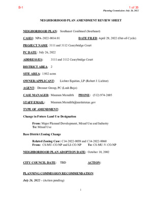
Planning Commission: July 26, 2022 NEIGHBORHOOD PLAN AMENDMENT REVIEW SHEET DATE FILED: April 29, 2022 (Out-of-Cycle) 3111 and 3112 Caseybridge Court NEIGHORHOOD PLAN: Southeast Combined (Southeast) CASE#: NPA-2022-0014.01 PROJECT NAME: 3111 and 3112 Caseybridge Court PC DATE: July 26, 2022 ADDRESS/ES: DISTRICT AREA: 2 SITE AREA: 1.982 acres OWNER/APPLICANT: Lichter Equities, LP (Robert J. Lichter) AGENT: Drenner Group, PC (Leah Bojo) CASE MANAGER: Maureen Meredith STAFF EMAIL: Maureen.Meredith@austintexas.gov TYPE OF AMENDMENT: Change in Future Land Use Designation PHONE: (512) 974-2695 From: Major Planned Development, Mixed Use and Industry To: Mixed Use Base District Zoning Change To: CS-MU-V-CO-NP Related Zoning Case: C14-2022-0059 and C14-2022-0060 From: CS-MU-CO-NP and LI-CO-NP NEIGHBORHOOD PLAN ADOPTION DATE: October 10, 2002 CITY COUNCIL DATE: TBD PLANNING COMMISSION RECOMMENDATION: July 26, 2022 – (Action pending) ACTION: 1 1 of 35B-1 Planning Commission: July 26, 2022 STAFF RECOMMENDATION: Staff supports the applicant’s request for Mixed Use land use. BASIS FOR STAFF’S RECOMMENDATION: Staff supports the applicant’s request for Mixed Use land use in large part because most of the property is currently zoned CS-MU- CO-NP. A small portion at the northwest corner is zoned LI-CO-NP. The proposed zoning of CS-MU-V-CO-NP is consistent with the proposed Mixed Use land use on the two tracts. In 2020 City Council approved the rezoning of 18 acres directly to the east for MF-4-NP zoning with a FLUM change to Multifamily Residential. This area is transitioning to include residential uses. Current future land uses E. Ben White Blvd SVR East Bound Industry Mixed Use Major Planned Development Multifamily Residential Below are sections for the Southeast Combined Neighborhood Plan for the area along E. Ben White where this property is located. 2 2 of 35B-1 Planning Commission: July 26, 2022 LAND USE DESCRIPTIONS EXISTING LAND USE ON THE PROPERTY Major Planned Developments - Master‐planned developments for large multi‐acre tracts that incorporate a wide variety of land uses that may include, but are not limited to, single family and multifamily residential, commercial, and clean industrial. Purpose 1. Provides flexibility in development for large sites but ensures compatibility between uses and good design. Application 1. Generally used to designate pre‐existing Planned Unit Developments or Planned Development Areas, or in response to proposed multiuse developments for large sites; 3 3 of 35B-1 Planning Commission: July 26, 2022 2. By designating an area for this land use, the neighborhood plan signifies its support for the entire range of land uses included in the definition; and This designation should not be applied to single‐use developments of any type. Industry - Areas reserved for manufacturing and related uses that provide employment but are generally not compatible with other areas with lower intensity use. Industry includes general warehousing, manufacturing, research and development, and storage of hazardous materials. Purpose 1. To confine potentially hazardous or nuisance‐creating activities to defined districts; 2. To preserve areas within the city to increase employment opportunities and increased tax base; 3. To protect the City’s strategic advantage as a high-tech job center; and 4. To promote manufacturing and distribution activities in areas with access to major transportation systems. Application 1. Make non‐industrial properties in areas with a dominant industrial character compatible with the prevailing land use scheme; 2. Where needed, require a buffer area for industrial property that abuts residentially used land; 3. Industry should be applied to areas that are not appropriate for residential or mixed use development, such as land within the Airport Overlay; 4. In general, mixed use and permanent residential activities are not appropriate in industrial areas. An exception may be the edge of an industrial area along the interface with an area in which residential activities are appropriate. Such exceptions should be considered case by case, with careful attention to both land use compatibility and design; 5. Industry should not be either adjacent to or across the road from single family residential or schools; 6. Use roadways and/or commercial or office uses as a buffer between residential and industry; and 7. Smaller scale “local manufacturing” districts may be appropriate in some locations to preserve employment opportunities and cottage industries of local artisans. In these areas, 4 4 of 35B-1 Planning Commission: July 26, 2022 hazardous industrial uses (i.e. basic industry, recycling centers, and scrap yards) should be prohibited. Mixed Use - An area that is appropriate for a mix of residential and non‐residential uses. Purpose 1. Encourage more retail and commercial services within walking distance of residents; 2. Allow live‐work/flex space on existing commercially zoned land in the neighborhood; 3. Allow a mixture of complementary land use types, which may include housing, retail, offices, commercial services, and civic uses (with the exception of government offices) to encourage linking of trips; 4. Create viable development opportunities for underused center city sites; 5. Encourage the transition from non‐residential to residential uses; 6. Provide flexibility in land use standards to anticipate changes in the marketplace; 7. Create additional opportunities for the development of residential uses and affordable housing; and 8. Provide on‐street activity in commercial areas after 5 p.m. and built‐in customers for local businesses. Application 1. Allow mixed use development along major corridors and intersections; 2. Establish compatible mixed‐use corridors along the neighborhood’s edge 3. The neighborhood plan may further specify either the desired intensity of commercial uses (i.e. LR, GR, CS) or specific types of mixed use (i.e. Neighborhood Mixed Use Building, Neighborhood Urban Center, Mixed Use Combining District); 4. Mixed Use is generally not compatible with industrial development, however it may be combined with these uses to encourage an area to transition to a more complementary mix of development types; 5. The Mixed Use (MU) Combining District should be applied to existing residential uses to avoid creating or maintaining a non‐conforming use; and 6. Apply to areas where vertical mixed use development is encouraged such as Core 5 5 of 35B-1 Planning Commission: July 26, 2022 Transit Corridors (CTC) and Future Core Transit Corridors. PROPOSED LAND USE ON THE PROPERTY Mixed Use - An area that is appropriate for a mix of residential and non‐residential uses. Purpose 1. Encourage more retail and commercial services within walking distance of residents; 2. Allow live‐work/flex space on existing commercially zoned land in the neighborhood; 3. Allow a mixture of complementary land use types, which may include housing, retail, offices, commercial services, and civic uses (with the exception of government offices) to encourage linking of trips; 4. Create viable development opportunities for underused center city sites; 5. Encourage the transition from non‐residential to residential uses; 6. Provide flexibility in land use standards to anticipate changes in the marketplace; 7. Create additional opportunities for the development of residential uses and affordable housing; and 8. Provide on‐street activity in commercial areas after 5 p.m. and built‐in customers for local businesses. Application 1. Allow mixed use development along major corridors and intersections; 2. Establish compatible mixed‐use corridors along the neighborhood’s edge 3. The neighborhood plan may further specify either the desired intensity of commercial uses (i.e. LR, GR, CS) or specific types of mixed use (i.e. Neighborhood Mixed Use Building, Neighborhood Urban Center, Mixed Use Combining District); 4. Mixed Use is generally not compatible with industrial development, however it may be combined with these uses to encourage an area to transition to a more complementary mix of development types; 5. The Mixed Use (MU) Combining District should be applied to existing residential uses to avoid creating or maintaining a non‐conforming use; and 6 6 of 35B-1 Planning Commission: July 26, 2022 6. Apply to areas where vertical mixed use development is encouraged such as Core Transit Corridors (CTC) and Future Core Transit Corridors. Yes Imagine Austin Decision Guidelines Yes Complete Community Measures Imagine Austin Growth Concept Map: Located within or adjacent to an Imagine Austin Activity Center, Imagine Austin Activity Corridor, or Imagine Austin Job Center as identified the Growth Concept Map. Name(s) of Activity Center/Activity Corridor/Job Center: • The property is within the Kinney Center Job Center Mobility and Public Transit: Located within 0.25 miles of public transit stop and/or light rail station. • The property is ~0.75 miles east of public transportation on Montopolis Drive and ~0.50 miles west of public transportation on E. Riverside Drive. Yes Mobility and Bike/Ped Access: Adjoins a public sidewalk, shared path, and/or bike lane. • There are sidewalks along E. Ben White Blvd Service Road and on Caseybridge Ct. Yes Connectivity, Good and Services, Employment: Provides or is located within 0.50 miles to goods and services, and/or employment center. Connectivity and Food Access: Provides or is located within 0.50 miles of a grocery store/farmers market. Connectivity and Education: Located within 0.50 miles from a public school or university. Yes Connectivity and Healthy Living: Provides or is located within 0.50 miles from a recreation area, park or walking trail. • Approximately 0.40 miles directly south is an urban trail. Connectivity and Health: Provides or is located within 0.50 miles of health facility (ex: hospital, urgent care, doctor’s office, drugstore clinic, and/or specialized outpatient care.) Yes Housing Affordability: Provides a minimum of 10% of units for workforce housing (80% MFI or less) and/or fee in lieu for affordable housing. • 10% of the proposed ~200 dwelling units will be affordable at 60% of regional medium family income. Yes Housing Choice: Expands the number of units and housing choice that suits a variety of household sizes, incomes, and lifestyle needs of a diverse population (ex: apartments, triplex, granny flat, live/work units, cottage homes, and townhomes) in support of Imagine Austin and the Strategic Housing Blueprint. Yes Mixed use: Provides a mix of residential and non-industrial uses. • Proposed first-floor commercial uses and ~200 residential uses. Culture and Creative Economy: Provides or is located within 0.50 miles of a cultural resource (ex: library, theater, museum, cultural center). Culture and Historic Preservation: Preserves or enhances a historically and/or culturally significant site. Creative Economy: Expands Austin’s creative economy (ex: live music venue, art studio, film, digital, theater.) Workforce Development, the Economy and Education: Expands the economic base by creating permanent jobs, especially in industries that are currently not represented in particular area or that promotes a new technology, and/or promotes educational opportunities and workforce development training. Industrial Land: Preserves or enhances industrial land. Number of “Yes’s” 7 Imagine Austin Priority Program PUD Specific Bonus Features Public Space Features and Public Art: Incorporates public space features and/or public art into project (Ex: plazas, streetscapes, gardens, and other people-friendly spaces where different ages can socially interact). Integrates and/or Expands Green Infrastructure: Preserves or expands Austin’s green infrastructure (ex: parkland, community gardens, green streets, creeks, stormwater features that mimic natural hydrology) into the urban environment and transportation network. Protects the Environment: Reduces greenhouse gas emissions, water, energy usage, and/or increases waste diversion. Protects Environmentally Sensitive Lands: Protects Austin’s natural resources and environmental systems by limiting land use and transportation development over or near environmentally sensitive areas, preserves open space, and protects natural resources more than ordinance requirements. 7 7 of 35B-1 Water/Wastewater Infrastructure: Sustainably manages Austin’s water resources and stream corridors through on-site use of storm water, effective landscaping, flood mitigation, and other low-impact development techniques more than ordinance requirements. Total Number of “Yes’s” Planning Commission: July 26, 2022 Proximity to Imagine Austin Activity Centers and Corridors 8 8 of 35B-1 Proximity to Public Parks Planning Commission: July 26, 2022 9 9 of 35B-1 Planning Commission: July 26, 2022 Proximity to Public Transportation IMAGINE AUSTIN GROWTH CONCEPT MAP Definitions Neighborhood Centers - The smallest and least intense of the three mixed-use centers are neighborhood centers. As with the regional and town centers, neighborhood centers are walkable, bikable, and supported by transit. The greatest density of people and activities in neighborhood centers will likely be concentrated on several blocks or around one or two intersections. However, depending on localized conditions, different neighborhood centers can be very different places. If a neighborhood center is designated on an existing commercial area, such as a shopping center or mall, it could represent redevelopment or the addition of housing. A new neighborhood center may be focused on a dense, mixed-use core surrounded by a mix of housing. In other instances, new or redevelopment may occur incrementally and concentrate people and activities along several blocks or around one or two intersections. Neighborhood centers will be more locally focused than either a regional or a town center. Businesses and services—grocery and department stores, doctors and dentists, shops, branch libraries, dry cleaners, hair salons, schools, restaurants, and other small and local businesses—will generally serve the center and surrounding neighborhoods. 10 10 of 35B-1 Planning Commission: July 26, 2022 Town Centers - Although less intense than regional centers, town centers are also where many people will live and work. Town centers will have large and small employers, although fewer than in regional centers. These employers will have regional customer and employee bases, and provide goods and services for the center as well as the surrounding areas. The buildings found in a town center will range in size from one-to three-story houses, duplexes, townhouses, and rowhouses, to low-to midrise apartments, mixed use buildings, and office buildings. These centers will also be important hubs in the transit system. Regional Centers - Regional centers are the most urban places in the region. These centers are and will become the retail, cultural, recreational, and entertainment destinations for Central Texas. These are the places where the greatest density of people and jobs and the tallest buildings in the region will be located. Housing in regional centers will mostly consist of low to high-rise apartments, mixed use buildings, row houses, and townhouses. However, other housing types, such as single-family units, may be included depending on the location and character of the center. The densities, buildings heights, and overall character of a center will depend on its location. Activity Centers for Redevelopment in Sensitive Environmental Areas - Five centers are located over the recharge or contributing zones of the Barton Springs Zone of the Edwards Aquifer or within water-supply watersheds. These centers are located on already developed areas and, in some instances, provide opportunities to address long-standing water quality issues and provide walkable areas in and near existing neighborhoods. State-of-the-art development practices will be required of any redevelopment to improve stormwater retention and the water quality flowing into the aquifer or other drinking water sources. These centers should also be carefully evaluated to fit within their infrastructural and environmental context. Job Centers - Job centers accommodate those businesses not well-suited for residential or environmentally- sensitive areas. These centers take advantage of existing transportation infrastructure such as arterial roadways, freeways, or the Austin-Bergstrom International airport. Job centers will mostly contain office parks, manufacturing, warehouses, logistics, and other businesses with similar demands and operating characteristics. They should nevertheless become more pedestrian and bicycle friendly, in part by better accommodating services for the people who work in those centers. While many of these centers are currently best served by car, the growth Concept map offers transportation choices such as light rail and bus rapid transit to increase commuter options. Corridors - Activity corridors have a dual nature. They are the connections that link activity centers and other key destinations to one another and allow people to travel throughout the city and region by bicycle, transit, or automobile. Corridors are also characterized by a variety of activities and types of buildings located along the roadway — shopping, restaurants and cafés, parks, schools, single-family houses, apartments, public buildings, houses of worship, mixed-use buildings, and offices. Along many corridors, there will be both large and small redevelopment sites. These redevelopment opportunities may be continuous along stretches of the corridor. There may also be a series of small neighborhood centers, connected by the roadway. Other corridors may have fewer redevelopment 11 11 of 35B-1 Planning Commission: July 26, 2022 opportunities, but already have a mixture of uses, and could provide critical transportation connections. As a corridor evolves, sites that do not redevelop may transition from one use to another, such as a service station becoming a restaurant or a large retail space being divided into several storefronts. To improve mobility along an activity corridor, new and redevelopment should reduce per capita car use and increase walking, bicycling, and transit use. Intensity of land use should correspond to the availability of quality transit, public space, and walkable destinations. Site design should use building arrangement and open space to reduce walking distance to transit and destinations, achieve safety and comfort, and draw people outdoors. BACKGROUND: The application was filed on April 29, 2022 which is out-of-cycle for neighborhood planning areas located on the east side of I.H.-35. The Southeast Combined Neighborhood Planning Contact Team submitted a letter to allow the application to be filed outside of the July open filing period for planning areas located on the east side of I.H.-35. The applicant proposes to change the land use on the future land use map from Major Planned Development and Industry to Mixed Use. A portion of the property already has Mixed Use land use. The applicant proposes to change the zoning on the property from CS-CO-MU-NP to CS-V- MU-CO-NP for a mixed use project to include approximately 200 residential units with first floor pedestrian-oriented uses. Of the ~200 residential units, 10% of the units will be affordable housing at 60% of the regional Median Family Income. For more information on the zoning request, please see the zoning case reports for C14-2022-0059 and C14-2022- 0060. PUBLIC MEETING: The ordinance-required community meeting was virtually held on June 22, 2022. The recorded meeting can be viewed at https://www.speakupaustin.org/npa. Approximately 409 community meeting notices were mailed to people who own property or have a City utility account within 500 feet of the property in addition to neighborhood and environmental groups who requested notification for the area. Two city staff members attended, Maureen Meredith and Susan Watkins, in addition to the applicant’s agents Leah Bojo and Drew Raffaele from Drenner Group, PC. No one from Southeast Combined Neighborhood Plan Contact Team or from the surrounding properties attended the meeting. Leah Bojo provided the following information on the proposed project. Her presentation from the community meeting is included at the end of this report. • The land area is 1.98 acres • The project includes two vacant tracts of land • Proposed are approximately 200 residential units with first floor pedestrian-oriented uses • Of the ~200 residential units, 10% of the units will be affordable for housing at 60% of the regional Median Family Income 12 12 of 35B-1 • 0.9-mile walk to Capital Metro Route 20. Buses arrive every 15 minutes (6 am – 8 Planning Commission: July 26, 2022 • Current zoning is CS-MU-CO-NP. The conditional overlay prohibits Adult Oriented Businesses, Convenience Storage, Vehicle Storage. A site plan or building permit may not be approved or issued if traffic generated exceeds 2,000 trips/day. • Current zoning is also LI-CO-NP. The conditional overlay is a site plan or building permit may not be approved or issued if traffic generated exceeds, 2,000 trips/day. • The requested zoning is CS-MU-V-CO-NP. The CO prohibiting Adult Oriented Businesses, Convenience Storage and Vehicle Storage will continue. pm) 13 13 of 35B-1 Applicant Summary Letter from Application Planning Commission: July 26, 2022 14 14 of 35B-1 Planning Commission: July 26, 2022 15 15 of 35B-1 Out-of-Cycle Authorization Letter from Southeast Combined NPCT Planning Commission: July 26, 2022 16 16 of 35B-1 Letter of Recommendation from the Neighborhood Plan Contact Team (NPCT) Planning Commission: July 26, 2022 (No letter as of July 19, 2022) From: Meredith, Maureen Sent: Thursday, July 14, 2022 4:12 PM To: a-aguirre@prodigy.net Cc: Leah Bojo <lbojo@drennergroup.com>; Drew Raffaele <draffaele@drennergroup.com>; Rhoades, Wendy <Wendy.Rhoades@austintexas.gov> Subject: SE Comb NPCT Rec: NPA-2022-0014.01_Caseybridge Ct Importance: High Hi, Ana: NPA-2022-0014.01 and zoning cases C14-2022-0059 and C14-2022-0060 for 3111 and 3112 Caseybridge Court is scheduled for the July 26 PC hearing. If you’d like the Southeast Combined NPCT’s letter of recommendation added to the staff case report, please email it to me no later than Tuesday, July 19, 2022 by 4:30 pm. If we get it after then, we will submit it as late back-up. Thanks. Maureen 17 17 of 35B-1 Planning Commission: July 26, 2022 Site 18 18 of 35B-1 Planning Commission: July 26, 2022 19 19 of 35B-1 Planning Commission: July 26, 2022 20 20 of 35B-1 Planning Commission: July 26, 2022 21 21 of 35B-1 Planning Commission: July 26, 2022 22 22 of 35B-1 Planning Commission: July 26, 2022 23 23 of 35B-1 Planning Commission: July 26, 2022 24 24 of 35B-1 Planning Commission: July 26, 2022 25 25 of 35B-1 Leah Bojo’s presentation at the June 22, 2022 Community Meeting Planning Commission: July 26, 2022 26 26 of 35B-1 Planning Commission: July 26, 2022 27 27 of 35B-1 Planning Commission: July 26, 2022 28 28 of 35B-1 Planning Commission: July 26, 2022 29 29 of 35B-1 Planning Commission: July 26, 2022 30 30 of 35B-1 Planning Commission: July 26, 2022 31 31 of 35B-1 Planning Commission: July 26, 2022 32 32 of 35B-1 Planning Commission: July 26, 2022 33 33 of 35B-1 Planning Commission: July 26, 2022 34 34 of 35B-1 Planning Commission: July 26, 2022 35 35 of 35B-1