09 C8J-2022-0177 - Easton Park Section 4B Preliminary Plan; District 2.pdf — original pdf
Backup
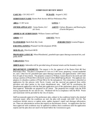
SUBDIVISION REVIEW SHEET LOT(S): 3 COUNTY: Travis AGENT: Carlson, Brigance, and Doering,Inc (AJ Zorn) PC DATE: August 9, 2022 JURISDICTION: Limited Purpose (Charles Brigance) CASE NO.: C8J-2022-0177 SUBDIVISION NAME: Easton Park Section 4B East Preliminary Plan AREA: 21.067 acres OWNER/APPLICANT: Carma Easton, LLC ADDRESS OF SUBDIVISION: William Cannon and Finial GRIDS: L12 WATERSHED: North Fork Dry Creek EXISTING ZONING: Planned Unit Development (PUD) MUD PLAN: Pilot Knob MUD PROPOSED LAND USE: Mixed Residential, greenbelt/open space/drainage easement lots, and public ROW VARIANCES: None SIDEWALKS: Sidewalks will be provided along all internal streets and the boundary street. DEPARTMENT COMMENTS: The request is for the approval of the Easton Park 4B East Preliminary Plan. The plan is comprised of 3 lots on 21.067 acres, proposing 1 mixed residential lot, and 2 other lots for greenbelt/open space/drainage easement, and approximately 1,905 linear feet of right-of-way/streets. The property connects to William Cannon Road to the north and will realign a portion of Finial Drive (formerly named Colton Bluff Springs Road). The applicant also proposes to abandon a portion of Finial Drive for the realignment. The owners have submitted an application for this process with Travis County, and has received pre-approval from utility providers and other parties to the street abandonment area. Staff will be coordinating the abandonment application with the final plat application (out of this preliminary plan) to Court for final approval. Sidewalks are proposed on all streets. The proposed lots comply with the PUD zoning requirements for use and lot size. Parkland will be in compliance with the PUD. Water and wastewater will be provided by the City of Austin. Staff recommends approval of the preliminary plan, subject to the conditions listed in the attached comment report. After the conditions are met, the plan will comply with LDC 30-2-84. The conditions include remove or update notes, update engineer’s report and drainage information, etc. These are administrative actions that require no discretionary review. An application that has been approved with conditions may be updated to address those conditions until the application expires and the plan does not need to be heard before the Commission again. STAFF RECOMMENDATION: Staff recommends approval of the preliminary plan, subject to the conditions listed in the comment report dated August 3, 2022 and attached as Exhibit C. CASE MANAGER: Sue Welch, Travis County Single Office Email address: Sue.Welch@traviscountytx.gov Exhibit A: Easton Park 4B East Preliminary Plan Exhibit B: Easton Park 4B Location Map Exhibit C: Easton Park 4B East Preliminary Plan Comment Report PHONE: 512-854-7637 CITY OF AUSTIN – TRAVIS COUNTY – SINGLE SUBDIVISION OFFICE SUBDIVISION APPLICATION – MASTER COMMENT REPORT July 11, 2022 UPDATE: PHONE #: U0 512-854-7637 C8J-2022-0177 00 Easton Park 4B East Preliminary Plan 7508 FM 1625 RD CASE NUMBER: REVISION #: CASE MANAGER: Sue Welch PROJECT NAME: LOCATION: SUBMITTAL DATE: REPORT DUE DATE: August 9, 2022 FINAL REPORT DATE: August 3, 2022 STAFF REPORT: This report includes all staff comments received to date concerning your most recent subdivision application submittal. The comments may include requirements, recommendations, or information. The requirements in this report must be addressed by an updated submittal. The subdivision application will be approved when all requirements from each review discipline have been addressed. If you have any questions, concerns or if you require additional information about this report, please contact your case manager at the phone number listed above or by using the contact information listed for each reviewer in this report. Any change to the plan/plat shall not cause noncompliance with any applicable code or criteria. In addition, any change to the plat may trigger new comments. UPDATE DEADLINE (LDC 30-2-56; 30-2-82): All comments must be addressed by filing an updated submittal prior to the update deadline of (90 days from submittal) which is October 10, 2022. Otherwise, the application will expire. If this date falls on a weekend or City of Austin holiday, the next City of Austin workday will be the deadline. Extension of Review Period, Extension of Update Deadline and Tolling of Application Period do not apply to applications for preliminary plan, plat or subdivision construction plans (LDC). UPDATE SUBMITTAL INSTRUCTIONS (LDC 30-1-113): A formal update submittal is required. 1. 2. a. b. 3. list of approved submittal dates. REVIEWERS: Planner 1 : Sophia Briones Addressing: Janny Phung AW Utility Development Services: Derek Tucker Environmental Review: Mel Fuechec Floodplain: Kena Pierce PARD: Robynee Heymans Travis Co. Subdivision: Sue Welch Applicants must contact Intake Staff (974-1770) in order to submit an update. Your update must include the following items: The revised plat/plan in pdf format A letter that addresses each comment in the master comment report Updates must be submitted on an approved submittal date. Refer to the submittal calendar for a 911 Addressing Review - Janny Phung - janny.phung@austintexas.gov AD1: This plat review is rejected for the following: AD2: Please remove the punctuation marks from the following: 1. COLTON BLUFF SPRINGS RD in the vicinity map 2. THAXTON RD in the vicinity map AD3: Please label streets in the ROW. The vicinity map does not show where the ROW segments are, only the labels AD4: Please update labels for the following: 1. MC KINNEY FALLS PKWY is the correct street name for this project 2. E WILLIAM CANNON DR the directional E must be included 3. FM 1625 RD street type must be included AD5: Please update COTA VISTA DR (Proposed) as it reads here for the unbuilt section. Please update COTA VISTA DR (Existing) for the built section. AD6: Vacation of the approximately 1000 ft of FINIAL DR west of FLATBUSH DR breaks street name continuity. If you are going to proceed, then a new name will be needed for the 1,060 ft of FINIAL DR between FLATBUSH DR and FM 1625 RD. Since the street is already dedicated as FINIAL DR, then one of actions below need to be performed: 1. Submit a street name change process with the City of Austin for the portion of FINIAL DR between FLATBUSH DR and FM 1625 RD 2. Replat the Right-of-Way portion of FINIAL DR between FLATBUSH DR and FM 1625 RD with a new name which has been reviewed, approved, and reserved NOTE: Punctuation or diacritical marks cause confusion for first responders NOTE: MC KINNEY FALLS PKWY is incorrectly labeled as MCKINNEY FALLS PKWY on all sheets. NOTE: Proposed ROW’s must be labeled to distinguish built from unbuilt ROW’s The standards applied to all new street names in Travis County can be found at this link: http://www.austintexas.gov/sites/default/files/files/Information_Technology/911Addressing/Street_Name_ Standards.pdf Active streets and address points can be viewed on Property Profile https://maps.austintexas.gov/GIS/PropertyProfile/ NOTE: After this plat has been Recorded, please submit your request for addresses by using the link below. https://subdivisionaddressrequest.azurewebsites.net/ Addressing Management Services has up to 15 working days to complete the assignment of addresses for a recorded plat. §30-2-155 End of Comment PARD / Planning & Design Review - Robynne Heymans - 512-974-9549 08/03/2022 Update - per Ordinance No. 20151217-080 PR 1: Please clarify if lot 2, block B is intended to be part of the greenbelt. If it part of the system please amend the label to ‘open space/greenbelt park’ and amend note 10 on to the plans: Parkland dedication is required per Ordinance No. 20151217-080 prior to approval of a final plat in this subdivision. The area to be dedicated as parkland is shown on this preliminary plan as Lot 2, Block B and Lot 3 Block F. PR 2: Please provide a trails exhibit to show how the trail will connect to sections east and west of the plans. PR 3: Please amend the label on Lot 3 F to read ‘open space/ greenbelt park’. PR 4: Define the boundaries of the drainage easement and water quality easement on the greenbelt park/open space blocks. Defining the easements areas is required so that park areas are not at risk of being lost by “blanket” easements. Also credited park acres needs to be determined to include Lot 2 Block B PR5: Provide a table on sheet 2 similar to previous preliminary plans (this table shows credited park acres). Be sure to include the 11+ acres from Lot 2, Block B Parkland dedication credits Uplands 100 yr flood plain 25 yr flood plain Drainage/ WQ easement # acres # acres # acres # acres PR 6: Please show on an updated tracking table for the whole PUD that you are up XX acres of parkland for the number of units on preliminary plans so far. This is separate from the open space tables submitted with this updated, those need to be updated as well to include acres from Lot 2, Block B.(Acres determined after step in PR 4). PR 7: Contact a PARD reviewer or engineer’s of prior prelims to obtain the format for tracking tables for this prelim. Referenced as a Pilot Knob PUD Open Space Summary Table. Robynne.heymans@austintexas.gov Flood Plain Review - Kena Pierce - 512-978-1832 Applicant must remedy all compliance issues without creating additional compliance issues with the LDC and/or Criteria manuals. A response that fails to correct an issue, or which creates other issues does not comply with the LDC and is insufficient to address the comments. The comments provided describe an issue that must be remedied in order for the application to be approved. Any specific examples are provided as a courtesy and are not intended as an exhaustive list, especially as the site may be updated to have additional compliance issues. Contact this reviewer if you have any questions at kena.pierce@austintexas.gov Reviewer’s Notes: Previously reviewed under C8J-2021-0043 cases. For some reason all of those show up as expired (Looks like AWU rejected the Prelim and the subsequent ones died in CC). Modeling has been previously reviewed for this site. Information pertaining to the floodplain study part of the project is contained within the appendices of the engineer’s report. Only Detention Pond model is included in the DSD files. FP on plans in report is specifically called out as A14. RAS/HMS models provided to Intake at U0. Case previously reviewed – it is resubmitted because the last application expired. Currently the plan is to leave Finial/Colton Bluff Road in place albeit it will be abandoned. HMS model matches model provided with SP-2021-0235 and SP-2021-0360. RAS PostProject matches the same above-listed cases; the Pre project is different (when using a diffing program to initially see where any differences are proposed). FP 1. The site, as shown on the plan provided, is not in compliance with the following sections of the Land Development Code. Please correct your application to be in compliance with Code 25-7-8/ 30-4-7 – Computation of Storm Runoff. a. Please submit the latest approved modeling to intake. b. RAS: In Pre project plan – XS 1250 should have blocked obstruction for the pond/low area on the right overbank. Also confirm downstream reach lengths as they are different between Pre and Post conditions but the cross sections are in the same location & orientation and are not changing. FP 2. The site, as shown on the plan provided, is not in compliance with the following sections of the Land Development Code. Please correct your application to be in compliance with Code 25-7-33 /30-4-33 – Floodplain Maps, Delineation, and Depiction. a. Please confirm or update the regulatory floodplain delineated by the latest approved modeling. b. Applicant must provide grading exhibit from the subdivision plans upstream of, and adjacent to, Cota Vista to prove that rises in WSEL are contained to existing drainage easement. If the rises are not contained to drainage easement, easement will need to be obtained prior to Subdivision Construction of this plan. The reason this is asked for now is to be able to easily carry forward a comment so we don’t have to re-review the models at subdivision construction unless there are changes to the grading that aren’t shown in the models here. The following are FYI comments from the model review. FYI: Geometries on Trib 1 are significantly different – though in most cases it looks like the part that is changing is outside the FP area or in the fringe and may be accurate per proposed grading for the development on either side, it still makes it hard to visually compare both geometries against each other. As such, review is limited to the area around the changing crossings instead. FYI: post project does not account for area 5A (this isn’t an issue for this case, just a statement for tracking purposes) FYI: RAS: Pre project conditions has different flows for Trib 1 than post project conditions. Confirm this is accurate (based on recent conversations, the applicant is using fully developed post project modeling HMS for both pre and post conditions to get an apples-to-apples comparison for water surface impacts while it is the drainage reviewer’s job to ensure that flows leaving the site are less than or equal to pre project conditions). Be aware that if it IS accurate that more flow is leaving the site in post project conditions than in pre project conditions, this project is considered non-compliant with code and cannot be administratively approved. • Per updated modeling provided at 1030 am on 7/28/2022, this issue has been addressed and the flows match in both versions and match HMS modeling. Modeling needs to be submitted at next update through DSD Intake so that there is a cohesive and complete case file. FYI: RAS Trib 2 – XS 837 should have the proposed detention pond in the right overbank, but since the proposed pond is outside the floodplain, there would be no change to the model results if they pond is entered. FYI: Correcting for the flows issue and the blocked obstruction issue listed above reduces the rises in water surface elevation to only occur upstream of Cota Vista and on Easton Park property. Applicant must confirm that rises in WSEL will be contained to drainage easement (I’m mostly concerned about the rises immediately upstream of Cota Vista on the right side as the floodplain is coincident with single family residential lots. Not correcting the flows/blocked obstruction/DS reach length results in larger rises in WSEL between pre and post.) AW Utility Development Services - Derek Tucker - 512-972-0077 AW1. Per Utility Criteria Manual Section 2, §15-9, §30-2, §25-5, §25-9, and the Uniform Plumbing Code: The landowner intends to serve each lot with City of Austin water and wastewater utilities. Each lot must have a separate water and wastewater utility connection and no existing or proposed plumbing may cross lot lines. The landowner, at own expense, will be responsible for providing the water and wastewater utility improvements, offsite main extensions, system upgrades, utility relocations and or abandonments to serve each lot. AW2. Per Utility Criteria Manual Section 2, §15-9, §30-2, §25-5, §25-9: Provide document numbers for the proposed water and wastewater easements shown on the preliminary plan. AW3. Per Utility Criteria Manual Section 2, §25-4: Add the following note to the plat: THE WATER AND/OR WASTEWATER EASEMENTS INDICATED ON THIS PLAT ARE FOR THE PURPOSE OF CONSTRUCTION, OPERATION, MAINTENANCE, REPAIR, REPLACEMENT, UPGRADE, DECOMMISSIONING AND REMOVAL OF WATER AND/OR WASTEWATER FACILITIES AND APPURTENANCES. NO OBJECTS, INCLUDING BUT NOT LIMITED TO, BUILDINGS, RETAINING WALLS, TREES OR OTHER STRUCTURES ARE PERMITTED IN WATER AND/OR WASTEWATER EASEMENTS EXCEPT AS APPROVED BY AUSTIN WATER. FYI. The landowner must pay the tap and impact fee once the landowner makes an application for a City of Austin water and wastewater utility tap permit. Water Quality Review - Don Heisch – (512) 978-1736 - Don.Heisch@austintexas.gov Release of this application does not constitute a verification of all data, information, and calculations supplied by the applicant. The engineer of record is solely responsible for the completeness, accuracy, and adequacy of his/her submittal, whether or not the application is reviewed for code compliance by city engineers. No Comments Wetlands Biologist Review - Leslie Lilly - Leslie.lilly@austintexas.gov No Wetland Biologist review comments at this time. Travis Co. Subdivision Review - Sue Welch - 512-854-7637 1. Provide a current tax certificate showing all taxes have been paid for 2021. 30-1-113 2. Add the case number in the lower right-hand corner of each page. Please contact this reviewer about information in the approval block. 30-1-113 3. It is this reviewer understand the owner wants to phase the preliminary plan into two plats. Please contact this reviewer – a phasing agreement or alternative fiscal agreement may be required with Travis County. Update note #38 to state “a portion of Finial will be vacate prior to final plat as depicted on this plan.” 30-1-113 4. Please upload the most current status of the requirements in the TNR TIA mitigation agreement with Travis County recorded in 20211173434, specifically the mitigation required under section 4b for applications submitted after 9/21/21 Travis Co. Transportation Review - Christine Connor - 512-854-7215 Travis Co. Drainage Construction Review - Christine Connor - 512-854-7215 No comments No comments Site Plan Plumbing - Cory Harmon - 512-974-2882 APPROVED The proposed preliminary plan (C8J-2022-0177) is approved from a plumbing code perspective. Electric Review - Andrea Katz - 512-322-6957 No Review Required. Out of Austin Energy service area, served by Bluebonnet Electric Cooperative, Inc. Drainage Engineering Review - Don Heisch – (512) 978-1736 - Don.Heisch@austintexas.gov Release of this application does not constitute a verification of all data, information, and calculations supplied by the applicant. The engineer of record is solely responsible for the completeness, accuracy, and adequacy of his/her submittal, whether or not the application is reviewed for code compliance by city engineers. No Comments Environmental Review - Mel Fuechec - mel.fuechec@austintexas.gov ADMINISTRATIVE VARIANCE [LDC 25-8, Article 1 / 30-5] EV 1 An Administrative Environmental Variance is required to vary the requirements of the following: • Section 25-8-341/30-5-341 (Cut Requirements) • Section 25-8-342/30-5-342 (Fill Requirements) Complete the following to proceed with the variance: • Contact this reviewer at mel.fuechec@austintexas.gov for a copy of the administrative variance • Complete the form and identify the scope / extent of the Administrative Environmental Variances request form; request; • Return the form to this reviewer; • Add a note to the cover sheet stating: “An administrative variance has been granted in accordance with LDC 25-8-42/ 30-5-42 to allow: CUT AND FILL FROM 4 TO 8 FEET IN DDZ [LDC 25-8-342/30-5-342] • Pay the Administrative Environmental Variance fee at Intake. For questions regarding fee amount, call 512-974-1770 or email LURIntake@austintexas.gov; • Provide receipt of payment in order to clear this comment. [LDC 25-8, Article 1 /30-5] END OF REPORT 13SHEETOFJOB NUMBERDATEDESIGNEDBY:DRAFTEDBY:BDFIRM ID #F3791Carlson, Brigance & Doering, Inc.CJOB NAME:PROJECT:SHEET NAME:Main Office5501 West William Cannon Dr.Austin, Texas 78749Phone No. (512) 280-5160Civil Engineering SurveyingNorth Office12129 RR 620 N., Ste. 600Austin, Texas 78750www.cbdeng.com5307EASTON PARK 4B EAST PLATPRELIMINARY PLANCBCPJULY 20227/1/2022 23SHEETOFJOB NUMBERDATEDESIGNEDBY:DRAFTEDBY:BDFIRM ID #F3791Carlson, Brigance & Doering, Inc.CJOB NAME:PROJECT:SHEET NAME:Main Office5501 West William Cannon Dr.Austin, Texas 78749Phone No. (512) 280-5160Civil Engineering SurveyingNorth Office12129 RR 620 N., Ste. 600Austin, Texas 78750www.cbdeng.com5307EASTON PARK 4B EAST PLATPRELIMINARY PLANCBCPJULY 20227/1/2022 33SHEETOFJOB NUMBERDATEDESIGNEDBY:DRAFTEDBY:BDFIRM ID #F3791Carlson, Brigance & Doering, Inc.CJOB NAME:PROJECT:SHEET NAME:Main Office5501 West William Cannon Dr.Austin, Texas 78749Phone No. (512) 280-5160Civil Engineering SurveyingNorth Office12129 RR 620 N., Ste. 600Austin, Texas 78750www.cbdeng.com5307EASTON PARK 4B EAST PLATPRELIMINARY PLANCBCPJULY 20227/1/2022 Easton Park 4B East Location Map Legend County Jurisdiction FULL PURPOSE LIMITED PURPOSE OTHER CITY LIMITS OTHER CITIES ETJ TCAD Parcels Jurisdiction FULL PURPOSE LIMITED PURPOSE OTHER CITY LIMITS OTHER CITIES ETJ Zoning Text EXTRATERRITORIAL JURISDICTION 2 MILE ETJ AGRICULTURAL AGREEMENT EXTRATERRITORIAL JURISDICTION 2 MILE ETJ AGRICULTURAL AGREEMENT Site 0.3 2-2-21 NAD_1983_StatePlane_Texas_Central_FIPS_4203_Feet 0 0.15 0.3 Miles This product is for informational purposes and may not have been prepared for or be suitable for legal, engineering, or surveying purposes. It does not represent an on-the-ground survey. This product has been produced by the City of Austin for the sole purpose of geographic reference. No warranty is made by the City of Austin regarding specific accuracy or completeness. 1: 9,600 Notes Easton Park 4B Location