City of Austin Housing and Plannin g Department P.O. Box 1088, Austin, TX 78767 -1088 (512) 974-3100 ♦ Fax (512) 974-3112 ♦ www .c ity o fau s tin .o rg/ h ou s in g MEMORANDUM TO: Todd W. Shaw, Chair & Planning Commission Members July 7, 2022 NPA-2021-0021.02 _1406-1506 Parker Lane C14-2021-0139_1406-1506 Parker Lane Maureen Meredith, Senior Planner, Inclusive Planning Division Heather Chaffin, Senior Planner, Current Planning Division Housing and Planning Department FROM: DATE: RE: The staff requests a postponement of the above-referenced cases from the July 12, 2022 Planning Commission hearing date to the August 23, 2022 hearing date to allow additional time for the applicant to work on the property’s drainage issue. This postponement request was made in a timely manner and meets the Planning Commission’s policy. Attachments: Plan Amendment Map Zoning Map The City of Austin is committed to compliance with the Americans with Disabilities Act and will provide reasonable modifications and equal access to communications upon request. 1 of 3B-3 The City of Austin is committed to compliance with the Americans with Disabilities Act and will provide reasonable modifications and equal access to communications upon request. 2 of 3B-3 The City of Austin is committed to compliance with the Americans with Disabilities Act and will provide reasonable modifications and equal access to communications upon request. 3 of 3B-3
City of Austin Ho using a nd P l a nning Depar tm ent P.O. Box 1088, Austin, TX 78767 -1088 (512) 974-3100 ♦ Fax (512) 974-3112 ♦ w w w .ci ty ofau s ti n .org/hou s i n g MEMORANDUM TO: Todd W. Shaw, Chair & Planning Commission Members July 12, 2022 Maureen Meredith, Senior Planner, Inclusive Planning Division Heather Chaffin, Senior Planner, Current Planning Division Housing and Planning Department NPA-2022-0023.01.SH_5107, 5109, 5111, 5113, & 5115 Lancaster Ct. C14-2022-0018.SH_5107, 5109, 5111, 5113, & 5115 Lancaster Ct. University Hills/Windsor Park Neighborhood Planning Area FROM: DATE: RE: Staff requests a postponement of the above referenced cases from the July 12, 2022 Planning Commission hearing to the July 26, 2022 hearing date. Staff is waiting for information from the Applicant regarding their SMART Housing application. This information is necessary prior to making recommendations on the NPA and rezoning applications. Attachments: Zoning Map Plan Amendment Map The City of Austin is committed to compliance with the Americans with Disabilities Act and will provide reasonable modifications and equal access to communications upon request. 1 of 3B-4 The City of Austin is committed to compliance with the Americans with Disabilities Act and will provide reasonable modifications and equal access to communications upon request. 2 of 3B-4 The City of Austin is committed to compliance with the Americans with Disabilities Act and will provide reasonable modifications and equal access to communications upon request. 3 of 3B-4
City of Austin Ho using a nd P l a nning Depar tm ent P.O. Box 1088, Austin, TX 78767 -1088 (512) 974-3100 ♦ Fax (512) 974-3112 ♦ w w w .ci ty ofau s ti n .org/hou s i n g MEMORANDUM TO: Todd W. Shaw, Chair & Planning Commission Members July 12, 2022 Maureen Meredith, Senior Planner, Inclusive Planning Division Heather Chaffin, Senior Planner, Current Planning Division Housing and Planning Department NPA-2022-0023.01.SH_5107, 5109, 5111, 5113, & 5115 Lancaster Ct. C14-2022-0018.SH_5107, 5109, 5111, 5113, & 5115 Lancaster Ct. University Hills/Windsor Park Neighborhood Planning Area FROM: DATE: RE: Staff requests a postponement of the above referenced cases from the July 12, 2022 Planning Commission hearing to the July 26, 2022 hearing date. Staff is waiting for information from the Applicant regarding their SMART Housing application. This information is necessary prior to making recommendations on the NPA and rezoning applications. Attachments: Zoning Map Plan Amendment Map The City of Austin is committed to compliance with the Americans with Disabilities Act and will provide reasonable modifications and equal access to communications upon request. 1 of 3B-5 The City of Austin is committed to compliance with the Americans with Disabilities Act and will provide reasonable modifications and equal access to communications upon request. 2 of 3B-5 The City of Austin is committed to compliance with the Americans with Disabilities Act and will provide reasonable modifications and equal access to communications upon request. 3 of 3B-5
Planning Commission: July 12, 2022 DATE FILED: April 4, 2022 (Out-of-Cycle) NEIGHBORHOOD PLAN AMENDMENT REVIEW SHEET 917 & 923 Shady Ln and 830 & 838 Airport Blvd NEIGHORHOOD PLAN: Govalle/Johnston Terrace Combined (Govalle) CASE#: NPA-2022-0016.01 PROJECT NAME: 830 Airport PC DATE: July 12, 2022 ADDRESS/ES: DISTRICT AREA: 3 SITE AREA: 2.48 acres OWNER/APPLICANT: Sam’s Radiator, Inc. and 838 Airport 2017, LP AGENT: Clinton Sayers CASE MANAGER: Maureen Meredith STAFF EMAIL: Maureen.Meredith@austintexas.gov TYPE OF AMENDMENT: Change in Future Land Use Designation From: Commercial and Single Family To: Mixed Use Base District Zoning Change To: CS-V-MU-CO-NP Related Zoning Case: C14-2022-0054 From: CS-CO-NP and SF-3-NP NEIGHBORHOOD PLAN ADOPTION DATE: March 2003 CITY COUNCIL DATE: July 28, 2022 PLANNING COMMISSION RECOMMENDATION: July 12, 2022 – (action pending) ACTION: PHONE: (512) 974-2695 1 of 30B-6 Planning Commission: July 12, 2022 STAFF RECOMMENDATION: Staff supports the applicant’s request for Mixed Use land use. BASIS FOR STAFF’S RECOMMENDATION: Staff supports the applicant’s request for Mixed Use land use because the property has frontage on Airport Blvd which is an activity corridor where mixed use zoning and land use is appropriate. The applicant proposes a mixed-use development that includes commercial services with residential units, 10% of which will be affordable to households earning 60% of the median family income (MFI). The proposed development will increase the number and variety of housing units to the city and the planning area. Below are sections of the Govalle/Johnston Terrace Combined Neighborhood Plan that supports the applicant’s request. 2 2 of 30B-6 Planning Commission: July 12, 2022 LAND USE DESCRIPTIONS EXISTING LAND USE ON THE PROPERTY Single family - Detached or two family residential uses at typical urban and/or suburban densities. Purpose 1. Preserve the land use pattern and future viability of existing neighborhoods; 2. Encourage new infill development that continues existing neighborhood patterns of development; and 3. Protect residential neighborhoods from incompatible business or industry and the loss of existing housing. Application 1. Existing single‐family areas should generally be designated as single family to preserve established neighborhoods; and 2. May include small lot options (Cottage, Urban Home, Small Lot Single Family) and two‐family residential options (Duplex, Secondary Apartment, Single Family Attached, Two‐Family Residential) in areas considered appropriate for this type of infill development. Commercial -Lots or parcels containing retail sales, services, hotel/motels and all recreational services that are predominantly privately owned and operated for profit (for example, theaters and bowling alleys). …
Planning Commission: July 12, 2022 DATE FILED: April 4, 2022 (Out-of-Cycle) NEIGHBORHOOD PLAN AMENDMENT REVIEW SHEET 917 & 923 Shady Ln and 830 & 838 Airport Blvd NEIGHORHOOD PLAN: Govalle/Johnston Terrace Combined (Govalle) CASE#: NPA-2022-0016.01 PROJECT NAME: 830 Airport PC DATE: July 12, 2022 ADDRESS/ES: DISTRICT AREA: 3 SITE AREA: 2.48 acres OWNER/APPLICANT: Sam’s Radiator, Inc. and 838 Airport 2017, LP AGENT: Clinton Sayers CASE MANAGER: Maureen Meredith STAFF EMAIL: Maureen.Meredith@austintexas.gov TYPE OF AMENDMENT: Change in Future Land Use Designation From: Commercial and Single Family To: Mixed Use Base District Zoning Change To: CS-V-MU-CO-NP Related Zoning Case: C14-2022-0054 From: CS-CO-NP and SF-3-NP NEIGHBORHOOD PLAN ADOPTION DATE: March 2003 CITY COUNCIL DATE: July 28, 2022 PLANNING COMMISSION RECOMMENDATION: July 12, 2022 – (action pending) ACTION: PHONE: (512) 974-2695 1 of 30B-7 Planning Commission: July 12, 2022 STAFF RECOMMENDATION: Staff supports the applicant’s request for Mixed Use land use. BASIS FOR STAFF’S RECOMMENDATION: Staff supports the applicant’s request for Mixed Use land use because the property has frontage on Airport Blvd which is an activity corridor where mixed use zoning and land use is appropriate. The applicant proposes a mixed-use development that includes commercial services with residential units, 10% of which will be affordable to households earning 60% of the median family income (MFI). The proposed development will increase the number and variety of housing units to the city and the planning area. Below are sections of the Govalle/Johnston Terrace Combined Neighborhood Plan that supports the applicant’s request. 2 2 of 30B-7 Planning Commission: July 12, 2022 LAND USE DESCRIPTIONS EXISTING LAND USE ON THE PROPERTY Single family - Detached or two family residential uses at typical urban and/or suburban densities. Purpose 1. Preserve the land use pattern and future viability of existing neighborhoods; 2. Encourage new infill development that continues existing neighborhood patterns of development; and 3. Protect residential neighborhoods from incompatible business or industry and the loss of existing housing. Application 1. Existing single‐family areas should generally be designated as single family to preserve established neighborhoods; and 2. May include small lot options (Cottage, Urban Home, Small Lot Single Family) and two‐family residential options (Duplex, Secondary Apartment, Single Family Attached, Two‐Family Residential) in areas considered appropriate for this type of infill development. Commercial -Lots or parcels containing retail sales, services, hotel/motels and all recreational services that are predominantly privately owned and operated for profit (for example, theaters and bowling alleys). …
ZONING CHANGE REVIEW SHEET CASE: C14-2022-0055 (803 /803 ½ West Ave) DISTRICT: 9 ADDRESS: 803 and 803 ½ West Avenue ZONING FROM: MF-4 TO: GO DMU* *On June 15, 2022, the applicant submitted a letter amending their request from GO to DMU (please see Applicant’s Amendment Request Letter - Exhibit D). SITE AREA: 0.3085 acres PROPERTY OWNER: Helen Ingram and Edsam Ingram AGENT: Harrison Pearson & Assoc. Inc. (Samuel T. Pritchard) CASE MANAGER: Sherri Sirwaitis (512-974-3057, sherri.sirwaitis@austintexas.gov) STAFF RECOMMEDATION: Staff recommends DMU-CO, Downtown Mixed Use-Conditional Overlay Combining District, zoning. The conditional overlay will limit the height on the property to a maximum of 60 feet. PLANNING COMMISSION ACTION / RECOMMENDATION: July 12, 2022 CITY COUNCIL ACTION: ORDINANCE NUMBER: B-81 of 15 C14-2022-0055 ISSUES: N/A CASE MANAGER COMMENTS: 2 The two lots under consideration are developed with single family residential homes. There are Personal Services (West End Salon and Crimson Hair Salon) to the north and west. The lots to the east are developed with office uses. To the south, there is an office use and a residence. The applicant is requesting DMU zoning to redevelop these lots with office uses. The property is located within the Northwest District in the Downtown Area Plan. The Downtown Area Plan calls for DMU 60 for these tracts (please see attached Exhibit D- Downtown Austin Plan Exhibits). The staff recommends DMU-CO, Downtown Mixed Use-Conditional Overlay Combining district, zoning. The proposed zoning is compatible and consistent with surrounding land uses and zoning patterns in this area and with the recommendations of the Downtown Area Plan. The applicant agrees with the staff’s recommendation. BASIS OF RECOMMENDATION: 1. The proposed zoning should be consistent with the purpose statement of the district sought. Downtown Mixed Use district is intended for areas on the periphery of CBD classifications in the central core area, permitting a variety of uses compatible with downtown Austin and allowing intermediate densities as a transition from the commercial core to surrounding districts. Site development regulations are intended to permit combinations of office, retail, commercial, and residential uses within a single development. 2. The proposed zoning should promote consistency and orderly planning. The proposed DMU zoning would be consistent with the DMU-CO zoning located to the north of this site. There are office and low intensity commercial uses to the north, south, east and west of the property under consideration. This property is located within the …
ZONING CHANGE REVIEW SHEET DISTRICT: 3 CASE: C14-2022-0001 2409 Town Lake Circle ZONING FROM: East Riverside Corridor (ERC) district - Neighborhood Mixed Use (NMU) subdistrict ZONING TO: East Riverside Corridor (ERC) district - Corridor Mixed Use (CMU) subdistrict ADDRESS: 2409 and 2413 Town Lake Circle SITE AREA: 3.308 acres PROPERTY OWNER: 2409 Town Lake Circle, LLC CASE MANAGER: Heather Chaffin (512-974-2122, heather.chaffin@austintexas.gov) STAFF RECOMMENDATION: Staff supports the Applicant’s request of ERC-CMU. For a summary of the basis of staff’s recommendation, see case manager comments on page 2. AGENT: Drenner Group, PC (Amanda Swor) PLANNING COMMISSION ACTION / RECOMMENDATION: July 12, 2022: CITY COUNCIL ACTION: July 28, 2022: ORDINANCE NUMBER: 1 of 11B-9 C14-2022-0001 2 CASE MANAGER COMMENTS: The subject property is located on the south side of Town Lake Circle in the East Riverside Corridor (ERC) planning area. The property is in the Neighborhood Mixed Use (NMU) subdistrict and is developed with 120 multifamily units that are approximately 36 years old. All of the other properties on the same side of Town Lake Circle are also developed with multifamily land uses. While the subject property and the property immediately to the west are in the NMU subdistrict, the remainder of the properties on the street are in the Corridor Mixed Use (CMU) subdistrict. Across Town Lake Circle is property that was previously developed with apartments that were demolished in 2008-2010 that is also in the CMU subdistrict. To the east and southeast of the subject property (along Pleasant Valley Drive) are other CMU subdistrict properties that include multifamily land use, undeveloped property, and retail-limited (HEB grocery) land uses. To the west and southwest (along East Riverside Drive) are properties that are in the NMU and CMU subdistricts. These properties are developed with commercial shopping centers with uses including restaurant-limited, retail, pawn shop and other uses. Please see Exhibits A, B, and C- Zoning Map, Aerial Exhibit and ERC Subdistrict Map. The ERC Regulating Plan states that the NMU subdistrict that is currently designated for the subject property, “provides for mid-rise residential with neighborhood-oriented retail and smaller employers. It is intended to have opportunities for attached residential and smaller-scale commercial uses.” The Regulating Plan also states that the proposed CMU subdistrict, “is the highest density district designation within the East Riverside Corridor and will typically consist of mixed use buildings such as residential or office uses over retail or office ground …
ZONING CHANGE REVIEW SHEET CASE: C14-2022-0047 – 701 and 703 Highland Ave Rezoning DISTRICT: 9 ZONING FROM: MF-4-HD-NP ADDRESS: 701 and 703 Highland Avenue TO: SF-4A-HD-NP SITE AREA: 0.2067 acres (9,003 square feet) (Steven Minor) AGENT: Gray Engineering, Inc. PROPERTY OWNER: Tracy Malone CASE MANAGER: Wendy Rhoades (512-974-7719, wendy.rhoades@austintexas.gov) STAFF RECOMMENDATION: The Staff recommendation is to grant single family residence-small lot – historic area – neighborhood plan (SF-4A-HD-NP) combining district zoning. The basis of Staff’s recommendation is provided on page 2. PLANNING COMMISSION ACTION / RECOMMENDATION: July 12, 2022: June 14, 2022: APPROVED A POSTPONEMENT REQUEST BY THE NEIGHBORHOOD TO JULY 12, 2022. [C. HEMPEL; J. SHIEH – 2ND] VOTE: 10-0, COMMISSIONERS HOWARD, MUSHTALER, AND THOMPSON – ABSENT CITY COUNCIL ACTION: July 28, 2022: ORDINANCE NUMBER: ISSUES: The Applicant has discussed this case with representatives of the Old West Austin Neighborhood Association (OWANA) Zoning Committee. Correspondence from the OWANA Zoning Committee is attached at the back of this report. CASE MANAGER COMMENTS: The subject platted lot is located at the north corner of Highland Avenue and the unbuilt Bellemont Street, and within the Smoot / Terrace Park Historic District. The subject lot is zoned multifamily residence – moderate-high density – historic area – neighborhood plan (MF-4-HD-NP) combining district zoning, and contains one single family residence on the south side and an undeveloped area on the north side. There is a single family residence and 1 of 15B-10 C14-2022-0047 Page 2 a triplex to the north, and single family residences to the east, south and west (MF-4-HD-NP; MF-4-H-HD-NP; SF-3-HD-NP; SF-3-H-HD-NP). Please refer to Exhibits A (Zoning Map) and A-1 (Aerial Exhibit). The Applicant has requested the single family residence-small lot – historic area – neighborhood plan (SF-4A-HD-NP) district in order to facilitate a resubdivision of the lot and build a single family residence on the north side of the rezoning area on a new lot. Changes are not proposed to the existing single family residence. The existing lot does not meet the minimum size required for a resubdivision to occur under the family residence (SF- 3) base zoning district (11,500 square feet would be needed), hence the need for the SF-4A base zoning district which has a minimum lot size of 3,600 square feet. BASIS FOR RECOMMENDATION 1. The proposed zoning should be consistent with the purpose statement of the district sought. The single family residence-small lot (SF-4A) district is intended …
CODE AMENDMENT INITIATION REVIEW SHEET Amendment: Consider initiation of amendments to Title 25 of the City Code related to the South Central Waterfront planning area. Description: The South Central Waterfront Vision Framework Plan was adopted by Council in 2016. Among the items included in the Framework Plan were community benefits and developer incentives; these items will be codified in the LDC as a voluntary, opt-in bonus program that will allow developers additional entitlements (above existing entitlements) in return for community benefits. Anticipated community benefits: • Affordable housing • Enhanced streetscapes • Pedestrian frontages • Reduced parking • Enhanced open space Anticipated developer incentives: • Additional height • Additional floor area • Additional land uses • Reduced parking required Proposed Language: TBD (draft ordinance language will be brought to PC for a recommendation before going to Council for final approval). Background: Initiation recommended by Codes and Ordinances Subcommittee on May 5, 2022. Staff Recommendation: NA Board and Commission Actions: Council Action: Ordinance Number: NA City Staff: Greg Dutton Phone: (512) 974-3509 Email: greg.dutton@austintexas.gov 1 1 of 1B-11
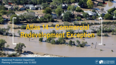
Atlas 14 – Commercial Redevelopment Exception Watershed Protection Department Planning Commission| July 12 2022 B-121 of 24 Floodplain Regulations Update What floodplain rules did we update? What floodplain rules do we recommend updating now? 2 B-122 of 24 What floodplain rules did we update? Most significant update to our floodplain rules in their 36-year history Goal of updated rules: Protect our residents from flooding based on a better understanding of flood risk with new rainfall information Updated four basic elements of rules • Floodplain definitions • Residential redevelopment exception • Colorado River exception • Freeboard 3 B-123 of 24 Residential Redevelopment Exception Administrative approval process floodplain if: 1. Replacement or modification of an existing residential building 2. Does not increase number of dwelling units 3. Finished floor elevation is at least 2 feet above the 100-year floodplain 4. No adverse flooding impact If these 4 conditions are met, the safe access requirement is waived Purpose • Incentivizes development that decreases flood risk • 80% of buildings in the 100-year floodplain are residential • Doesn’t increase the number of dwelling units at risk of flooding • Opens up opportunity for grant Existing condition Re-developed condition funding B-124 of 24 Result of Collaborative Code Revision Process Contacted more than 2,700 people at 110 different meetings City Council approved the new rules on November 14, 2019 Staff pledged to develop draft rules regarding commercial redevelopment B-125 of 24 What floodplain rules do we recommend updating now? Commercial Redevelopment Exception 6 B-126 of 24 Commercial Redevelopment exception Goal: Create an administrative approval process for commercial redevelopment that decreases flood risk compared to the existing conditions Considerations: Building use; square footage; occupant load; parking flood risk; building height 7 B-127 of 24 Proposed commercial redevelopment exception Administrative approval process for a commercial building in the floodplain if: 1. Replaces or modifies an existing commercial building 2. Finished floor elevation is at least 2 feet above the 100-year floodplain 4. Does not include the following uses: E (Educational); F (Factory); H (High Hazard); or I (Institutional) 5. Does not increase the number or flood level of parking spaces within the floodplain on the property unless otherwise required; and 3. Does not increase the building square 6. No adverse flooding impact footage on the property If these conditions are met, the safe access requirement is waived B-128 of 24 Proposed commercial redevelopment exception example: Existing conditions 14 …
C20-2022-002 ORDINANCE AMENDMENT REVIEW SHEET Amendment: C20-2022-002 Commercial Parkland Dedication Description: Consider an amendment to Title 25-1 of the City Code to require parkland dedication for commercial developments. Proposed Language: See attached draft ordinance. Summary of proposed code amendment • Parkland dedication would apply to new commercial developments, specifically office, retail, industrial/warehouse, and hotel uses. This would be in addition to the existing residential requirements currently in effect. The commercial requirement would use the current formula of 9.4 acres of parkland per 1,000 new users of the parks system. The commercial uses would be calculated based on the number of employees per square foot, discounted by hours of operation, occupancy rate, and commuter percentage rates. Criteria for dedication and fee in-lieu would remain the same as for residential developments. • • Background: Initiated by City Council Resolution 20220407-042 On April 7, 2022, Council approved resolution No. 20220407-042, which initiated code amendments to the Parkland Dedication Ordinance in City Code Chapter 25- I (General Requirements and Procedures) to require parkland dedication for office, industrial, and commercial developments; and directed the City Manager to place the code amendment on an upcoming Council agenda that provides Council with sufficient time to adopt the ordinance and place the fee into the Fiscal Year 2023 budget; a 10-0 vote with Council Member Harper-Madison off the dais. Staff Recommendation: Staff brings forward the amendment with recommendation. Board and Commission Actions July 12, 2022: To be reviewed by the Planning Commission. July 25, 2022: To be reviewed by the Parks and Recreation Board. Council Action June 16, 2022: A public hearing has been scheduled for July 28, 2022 Ordinance Number: NA City Staff: Randy Scott Email: Randy.Scott@austintexas.gov Phone: 512-974-9484 1 1 of 75B-13 PROPOSED CHANGES TO ARTICLE 14 (PARKLAND DEDICATION) ADDING COMMERCIAL PARKLAND DEDICATION REQUIREMENTS DRAFT SUBJECT TO ADDITIONAL CHANGES ARTICLE 14. PARKLAND DEDICATION.1 § 25-1-601 GENERAL PROVISIONS. (A) The City of Austin has determined that recreational areas in the form of public parks are necessary for the well-being of residents and employees. The City has further determined that the approval of new residential and commercial development is reasonably related to the need for additional parkland and park amenities to serve new development. This article establishes a fair method for determining parkland dedication, or the payment of a fee in-lieu of dedication, to be required as a condition to the approval of new development in an amount …
TO: FROM: DATE: SUBJECT: M E M O R A N D U M Andrew Rivera, Planning Commission Jacquelyn Armstrong, Property Agent Senior Land Management, Development Services Department July 05, 2022 F#2021-155370 LM Street Right-of-Way Encroachments of aerial 2nd floor balcony as well as amenity and lobby areas on floors 13-16. Attached is the Application Packet and Master Comment Report pertaining to a request to encroach into the right-of- way of East 2nd Street. The right of way is fully paved and heavily traveled by vehicles and pedestrians. The proposed encroachments are for a 182 square foot area to be used for a 2nd floor restaurant balcony and an 886 square foot area to be used for an amenity and lobby encroachment on floors 13-16. The abutting properties are owned by 2nd Street Development LLC. Per the transmittal letter dated March 16, 2022, received by the City of Austin, the applicant states: the proposed encroachments support the Priority Programs identified in the Imagine Austin Comprehensive Plan. The abutting tract is currently associated with the site plan under SP-2021-0172C. All affected departments and private utility franchise stakeholders have reviewed the application and recommend approval, subject to the reviewers’ conditions shown on the attached Master Comment Report. Per City Code §14-11-54 – Notice to any registered neighborhood organization whose boundaries are within all or a portion of the encroachment area. A neighborhood plan contact team or registered neighborhood organization whose boundaries are within all or a portion of the encroachment area may submit comments regarding the proposed encroachment. No comments were received by staff. The applicant has requested that this item be submitted for placement on the July 12, 2022, Planning Commission Agenda. Staff contact: Jacquelyn Armstrong, Land Management, Property Agent Senior Development Services Department, 512-974-7149, jacquelyn.armstrong@austintexas.gov Harrison M. Hudson/Kimley Horn 737-202-3202/Harrison.hudson@kimley-horn.com Applicant: Abutting Landowner: 2nd Street Development LLC. The applicant and/or property owner’s representative will be present at the meeting to answer any questions regarding future development and encroachment request. Attachments: Summary of Review Comments Report and Application Packet 1 of 55B-14 Page 1 Mashell Smith City of Austin Development Services Department 6310 Wihelmina Delco Dr. Austin, TX 78752 03/16/2022 RE: Encroachment Agreement Application Transmittal Letter 307 E 2nd Street - SP-2021-0172C On behalf of our clients, Knight Family Partnership LTD. and M.M Reynolds 67 M.OM. Trust, Kimley Horn is submitting an encroachment agreement application to construct and maintain above grade …
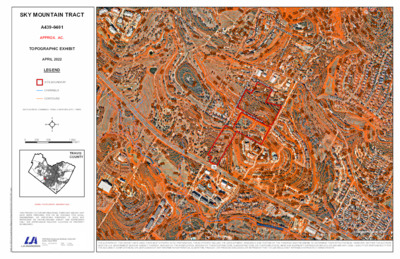
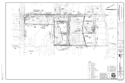
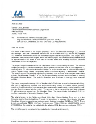
SITE PLAN REVIEW SHEET ENVIRONMENTAL VARIANCE REQUEST ONLY CASE: SP-2021-0079C P.C. COMMISSION DATE: July 12, 2022 COUNCIL DISTRICT: 8 PROJECT NAME: Sky Mountain APPLICANT: LJA Engineering, Inc. AGENT: Reese Hurley ADDRESS OF SITE: 8722 W SH 71, Austin, Tx, 78735 COUNTY: Travis WATERSHED: Williamson Creek AREA: West Oak Hill JURISDICTION: Full Purpose EXISTING ZONING: LR-MU-NP, MF-1-NP PROPOSED DEVELOPMENT: Multi-family with associated improvements DESCRIPTION OF VARIANCE: The applicant requests the following: 1. Request to vary from LDC 25-8-341 to allow cut over 4 feet to 16 feet. STAFF RECOMMENDATION: Staff recommends the variance, having found that the required findings of fact have been met. ENVIRONMENTAL BOARD ACTION: 06/01/2022: The Environmental Board voted in (8) favor for the approval of the requested variance, (0) in denial of the requested variance, (3) absent. ZONING AND PLATTING COMMISSION ACTION: ENVIRONMENTAL REVIEW STAFF: Pamela Abee-Taulli PHONE: 512-974-1879 CASE MANAGER: Kate Castles PHONE: 512-974-4555 1 of 14 1 ENVIRONMENTAL COMMISSION MOTION 20220601 003b Date: June 1, 2022 Subject: Sky Mountain, SP-2021-0079C Seconded by: Kevin Ramberg Motion by: Jennifer L. Bristol RATIONALE: WHEREAS, the Environmental Commission recognizes the applicant is requesting a variance from LDC 25- 8-341 to allow cut over 4 feet to 16 feet; and WHEREAS, the Environmental Commission recognizes the site is located in the Williamson Creek, Barton Springs Zone Classification, Drinking Water Protection Zone; and WHEREAS, the Environmental Commission recognizes that Staff recommends this variance, (with three staff conditions) having determined the required Findings of Fact have been met. THEREFORE, the Environmental Commission recommends the variance request with the following: Staff Conditions: 1. All grading over 8 feet will be contained with terracing or engineered walls. 2. Around the perimeter of the limits of construction, and in areas where more than 3’ of vertical rise is proposed, 3:1 slopes will have erosion control matting applied immediately after final grade is achieved. 3. Disturbance in the stormwater irrigation fields will be minimized by restricting the LOC and routing the irrigation lines to preserve existing trees to the greatest extent possible. VOTE 8-0 Approved By: For: Thompson, Schiera, Nickells, Bristol, Ramberg, Aguirre, Brimer, Bedford Against: None Abstain: None Recuse: None Absent: Qureshi, Scott, and Barrett Bixler Kevin Ramberg, Environmental Commission Chair 2 of 14 Development Services Department Staff Recommendations Concerning Required Findings Project Name: Ordinance Standard: Watershed Protection Ordinance Variance Request: Sky Mountain Request to vary from LDC 25-8-341 to allow cut over 4 feet …
9429489169548949749681026936916960956910962908924990944978942940988992986926101495895690493092210421002900970932100410301006946918994103291492210069529789469981036100894410361010100093893410109568869789389329909569949501006898996888898948920936900924936100010329841006958100495293810129069289888949349909669129969189529489449161040924904972920972926934914906102289088610161002103010329869708969781034100296010101004916936958960984922942970946922964960924100898296210368849689221024103890890692010149029189729029049409769409289809349729881034976974962966998942906956962968958100896695095296093097096410109409449649269461032984942952956992948946898950918101297810309521012920990102893095497299491493491210281022992966962910968964100895210269369389869609281028103093092895010108881026954982102810189129481024102010169321006980976100210229741014100894294495292694495493694095094610009561024938958966960962968996964101297297093293410141008101810161020994101293493210109409429301004100289299810009969949929909369889869449849829389809769489781020974950972902101610149409529449549421018918956962964966960910908968958964960968962966970970948100691295095495699610049989941000972976982984980974978986990992988WILLIAMSONCREEK³±71MEDICINECREEKDROLDBEECAVESRDSUNSET RDGSKY MOUNTAIN DRMOUNTAIN SHADOWS DRCOVEREDBRIDGEDRTRAVISHILLSDRREHOBETHCIRSHUMARDOAKTRLCEDARELMTRLOLEANDERTRLTRAVIS COOK RDBELL DRMOUNTAINCRESTDRFORTBENTONDRCopyright nearmap 2015Path: K:\GIS\LJA Austin\Due Diligence Report\A439-0401\A439.0401.aprxTHE AUTHORS OF THIS EXHIBIT HAVE USED THEIR BEST EFFORTS IN ITS PREPARATION. THESE EFFORTS INCLUDE THE DEVELOPMENT, RESEARCH, AND TESTING OF THE THEORIES AND PROGRAMS TO DETERMINE THEIR EFFECTIVENESS. HOWEVER, NEITHER THE AUTHORSNOR THE U.S. GOVERNMENT NOR ANY AGENCY THEREOF, NOR ANY OF THEIR EMPLOYEES, NOR ANY OF THEIR CONTRACTORS, SUBCONTRACTORS, OR THEIR EMPLOYEES, MAKE ANY WARRANTY EXPRESS OR IMPLIED, OR ASSUME ANY LEGAL LIABILITY OR RESPONSIBILITY FORTHE ACCURACY, COMPLETENESS, OR USEFULNESS OF ANY INFORMATION APPARATUS, ALGORITHM, PRODUCT, OR PROCESS DISCLOSED, OR REPRESENT THAT ITS USE WOULD NOT INFRINGE ON PRIVATELY OWNED RIGHTS.THIS PRODUCT IS FOR INFORMATIONAL PURPOSES AND MAY NOTHAVE BEEN PREPARED FOR OR BE SUITABLE FOR LEGAL,ENGINEERING, OR SURVEYING PURPOSES. IT DOES NOTREPRESENT AN ON-THE-GROUND SURVEY AND REPRESENTSONLY THE APPROXIMATE RELATIVE LOCATION OF PROPERTYBOUNDARIES.AERIAL PHOTOGRAPH: NEARMAP 2022TRAVISCOUNTY05001,000250FEETDATA SOURCE: CHANNELS - FEMA, CONTOURS (2FT) - TNRISSITE BOUNDARYCHANNELSCONTOURSLEGENDAPRIL 2022TOPOGRAPHIC EXHIBITAPPROX. AC.A439-0401SKY MOUNTAIN TRACT1 of 5 EDWARDS AQUIFERCONTRIBUTING ZONEWILLIAMSONCREEK³±71MEDICINECREEKDROLDBEECAVESRDSUNSET RDGSKY MOUNTAIN DRMOUNTAIN SHADOWS DRCOVEREDBRIDGEDRTRAVISHILLSDRREHOBETHCIRSHUMARDOAKTRLCEDARELMTRLOLEANDERTRLTRAVIS COOK RDBELL DRMOUNTAINCRESTDRFORTBENTONDR¬«886¬«883¬«913¬«918¬«940¬«906¬«901¬«894¬«898Copyright nearmap 2015Path: K:\GIS\LJA Austin\Due Diligence Report\A439-0401\A439.0401.aprxTHIS PRODUCT IS FOR INFORMATIONAL PURPOSES AND MAY NOTHAVE BEEN PREPARED FOR OR BE SUITABLE FOR LEGAL,ENGINEERING, OR SURVEYING PURPOSES. IT DOES NOTREPRESENT AN ON-THE-GROUND SURVEY AND REPRESENTSONLY THE APPROXIMATE RELATIVE LOCATION OF PROPERTYBOUNDARIES.AERIAL PHOTOGRAPH DATE: NEARMAP 2022TRAVISCOUNTY05001,000250FTDATA SOURCE: FLOODPLAIN DATA - FEMA, EDWARDS AUIFER -TCEQ, EROSION BUFFER AREA, CEF BUFFER - CITY OFAUSTIN, GCW HABITAT OVERLAY - USFWSBFECHANNELS100 YEAR500 YEARZONE ASITE BOUNDARYEDWARDS AQUIFERCONTRIBUTING ZONEEROSION HAZARDBUFFER AREACRITICALENVIRONMENTFEATURE BUFFERLOW QUALITY GCWHABITATMEDIUM QUALITYGCW HABITATHIGH QUALITY GCWHABITATLEGENDAPRIL 2022ENVIRONMENTAL EXHIBITAPPROX. 22 AC.A439-0401SKY MOUNTAIN TRACT2 of 5 IR IR IR IR IR IR IR IR IR IR IR IR 5' INTERIOR SETBACK IR IR IR IR IR I R 5' INTERIOR SETBACK NUMBER MIN ELEV MAX ELEV COLOR I R I R 2 0 X E T E E H S E E S R I R I A 995 990 5 8 9 1+00 15' WL ESMT DOC. NO. __________ WATER QUALITY / DETENTION ESMT DOC. NO. __________ B 1+00 1+50 2+00 2+50 3+00 3+50 4+00 4+50 5+00 5+50 6+00 6+50 7+00 B IRRIGATION AREA B R I I R IR MOUNTAIN SHADOWS DR. . I R D N A T N U O M Y K S I R 15' STREET SIDE SETBACK I R IR IR IR IR I R I R IR IR PARKLAND ESMT. DOC. NO. __________ IRRIGATION AREA A WATER QUALITY / DETENTION …
) W O R ' 0 5 1 ( 1 7 H S W N TIO C E S R E T IN 7 1 1 9 1 O F O F O F ZONING:AG-NP K C A B T E S ' 5 2 5 1 0 0 9 6 H F 6 0 0 0 9 6 3 1 0 0 9 6 N W O N K N U 2 0 2 4 2 N TIO C E S R E T IN N TIO C E S R E T IN N W O N K N U 4 7 2 4 3 2 0 8 2 4 3 2 1 8 2 4 3 2 5 8 2 4 3 2 6 8 2 4 3 2 H F O F O F O F ROW DEDICATION AND FUTURE MOUNTAIN SHADOWS DRIVE IMPROVEMENTS BY OTHERS ZONING: AG-NP INTERSECTION 11070 ZONING: MF-1-NP INTERSECTION 19650 MOUNTAIN SHADOWS DR. 226024 INTERSECTION 23376 INTERSECTION 9047 ZONING: MF-1-NP ZONING: MF-1-NP ZONING: RR-NP 25' BLDG SETBACK 25' BLDG SETBACK 15' STREET SIDE SETBACK LOT 1, BLOCK A MOUNTAIN CREST SUBDIVISION ZONING: LR-MU-NP S W O D A H S N A T N U O M I ZONING: MF-1 F-1 G: M NIN O Z F-1 G: M NIN O Z F-1 G: M NIN O Z 5' INTERIOR SETBACK F-1 G: M NIN O Z P R-N G: R NIN O Z K C A B T E S R O R E T N I I ' 5 ZONING: MF-1 N28°12'59"E 404.99' PROPOSED D.E. DOC. #____________ BY PLAT K C A B T E S R O I R E T N I 5' ZONING: MF-1 5' INTERIOR SETBACK ZONING: MF-1-NP ZONING:MF-1 ZONING: MF-1 . I R D N A T N U O M Y K S K C A B T E S R O R E T N I I ' 5 ' 5 0 . 5 2 3 ' W " 7 0 3 5 ° 1 6 N ' 1 0 . 5 2 5 ' W " 7 4 2 5 ° 1 6 N ' 2 9 . 4 2 3 ' E " 1 5 2 5 ° 1 6 S S28°14'30"W 399.04' N28°17'57"E 381.31' 5' INTERIOR SETBACK ZONING: MF-1-NP 5 ' I N T E R I O R S …
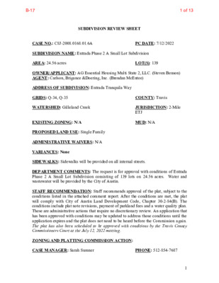
SUBDIVISION REVIEW SHEET CASE NO.: C8J-2008.0168.01.6A PC DATE: 7/12/2022 SUBDIVISION NAME: Entrada Phase 2 A Small Lot Subdivision AREA: 24.56 acres LOT(S): 139 OWNER/APPLICANT: AG Essential Housing Multi State 2, LLC. (Steven Benson) AGENT: Carlson, Brigance &Doering, Inc. (Brendan McEntee) ADDRESS OF SUBDIVISION: Entrada Tranquila Way GRIDS: Q-34, Q-35 COUNTY: Travis WATERSHED: Gilleland Creek JURISDICTION: 2-Mile ETJ EXISTING ZONING: N/A MUD: N/A PROPOSED LAND USE: Single Family ADMINISTRATIVE WAIVERS: N/A VARIANCES: None SIDEWALKS: Sidewalks will be provided on all internal streets. DEPARTMENT COMMENTS: The request is for approval with conditions of Entrada Phase 2 A Small Lot Subdivision consisting of 139 lots on 24.56 acres. Water and wastewater will be provided by the City of Austin. STAFF RECOMMENDATION: Staff recommends approval of the plat, subject to the conditions listed in the attached comment report. After the conditions are met, the plat will comply with City of Austin Land Development Code, Chapter 30-2-84(B). The conditions include plat note revisions, payment of parkland fees and a water quality plan. These are administrative actions that require no discretionary review. An application that has been approved with conditions may be updated to address those conditions until the application expires and the plat does not need to be heard before the Commission again. The plat has also been scheduled to be approved with conditions by the Travis County Commissioners Court at the July 12, 2022 meeting. ZONING AND PLATTING COMMISSION ACTION: CASE MANAGER: Sarah Sumner PHONE: 512-854-7687 1 1 of 13B-17 Email address: sarah.sumner@traviscountytx.gov 2 2 of 13B-17 CONSUMER PROTECTION NOTICE FOR HOMEBUYERS. IF YOU ARE BUYING A LOT IN THIS SUBDIVISION, YOU SHOULD DETERMINE WHETHER THE SUBDIVISION AND THE LAND AROUND IT ARE INSIDE OR OUTSIDE THE CITY LIMITS. THIS CAN AFFECT THE ENJOYMENT AND VALUE OF YOUR HOME. DEPENDING ON STATE LAW AND OTHER FACTORS, LAND OUTSIDE THE CITY LIMITS MAY BE SUBJECT TO FEWER LOCAL GOVERNMENT CONTROLS OVER THE DEVELOPMENT AND USE OF LAND THAN INSIDE THE CITY LIMITS. THE SUBDIVISION'S RESTRICTIVE COVENANTS MAY CREATE PRIVATELY ENFORCEABLE RESTRICTIONS AGAINST INCOMPATIBLE LAND USES WITHIN THE SUBDIVISION, WHETHER IT IS INSIDE OR OUTSIDE THE CITY LIMITS. DEPENDING ON STATE LAW AND OTHER FACTORS, HOWEVER OUTSIDE THE CITY LIMITS NEITHER PRIVATE NOR GOVERNMENTAL RESTRICTIONS MAY BE AVAILABLE TO (1) RESTRICT EITHER THE NATURE OR EXTENT OF DEVELOPMENT NEAR THE SUBDIVISION, OR (2) PROHIBIT LAND USES NEAR THE SUBDIVISION THAT ARE INCOMPATIBLE WITH A RESIDENTIAL NEIGHBORHOOD. …
Please accept this note as GEI’s formal request for postponement of zoning case C14-2022-0047 at 701 – 703 Highland Avenue. We would like to request to be postponed to the next available meeting, on July 26th. TO: City of Austin Planning Commission FROM: Steven Minor, P.E. DATE: July 11, 2022 Re: Zoning Case C14-2022-0047 Postponement Planning Commission Members, Thanks, Steven Minor, P.E. Gray Engineering, Inc. --- Consulting Engineers TBPELS Firm 2946 8834 N. Capital of Texas Highway, Suite 140 Austin, TX 78759 Phone: 512.452.0371 Fax: 512.454.9933
Good afternoon, Chairman Shaw and Commissioners – I am reaching out to ask that the Planning Commission postpone Item B-12 Flood Regulations to require that planning staff ensure 1. all federal and state floodplain management standards are met, 2. federal and state review procedures have been followed, 3. that the City will be fully compliant with all FEMA requirements so citizens can obtain federal flood insurance, and 4. to institutionally design governance checks and balances so that “director determination” does not risk establishing a de facto policy making process with a single point of influence. It is in all interests to postpone this proposed ordinance change to ensure engagement with all stakeholders and compliance with all federal and state regulations, statutes, and laws. Once finalized, outreach should be carried out to ensure that Austinites know LDC code changes will not put them in flooding danger or prevent them from buying affordable flood insurance. What is most troubling about this proposed ordinance change is Section A (1) and (2): § 25-7-93 GENERAL EXCEPTIONS. 4 (A) A development application with a proposed building or parking area that 5 encroaches on the 100-year floodplain may be approved if the encroachment is: (1) a parking area that is smaller than 5,000 square feet or an unoccupied structure that has an area of less than 1,000 square feet, and the director determines that the proposed development: (a) will not have an adverse effect on the 100-year floodplain or surrounding properties; and (b) otherwise complies with the requirements of this title; Without ensuring the first three concerns listed above are met, staff is not mitigating the peril that: • Austin will fail to meet FEMA requirements for citizens to be able to buy federally subsidized • Allow additional impervious cover that will potentially cause flooding downstream in the flood flood insurance, and plain. It was only last week that the proposed revised ordinance became available to the public. All that has been posted in Backup is last week’s ordinance draft and a slide deck. The slide deck makes no mention of carrying out policy analysis to ensure that concerns 1-3 above have been met. In the procedures followed section of the deck, there is no mention of when federal or state review will occur or recognition of federal and state stakeholders. There is no mention of SWOT analysis (Strengths, Weaknesses, Opportunities, Threats) having been done, much …