SITE PLAN REVIEW SHEET ENVIRONMENTAL VARIANCE REQUEST ONLY CASE: SP-2021-0079C P.C. COMMISSION DATE: July 12, 2022 COUNCIL DISTRICT: 8 PROJECT NAME: Sky Mountain APPLICANT: LJA Engineering, Inc. AGENT: Reese Hurley ADDRESS OF SITE: 8722 W SH 71, Austin, Tx, 78735 COUNTY: Travis WATERSHED: Williamson Creek AREA: West Oak Hill JURISDICTION: Full Purpose EXISTING ZONING: LR-MU-NP, MF-1-NP PROPOSED DEVELOPMENT: Multi-family with associated improvements DESCRIPTION OF VARIANCE: The applicant requests the following: 1. Request to vary from LDC 25-8-341 to allow cut over 4 feet to 16 feet. STAFF RECOMMENDATION: Staff recommends the variance, having found that the required findings of fact have been met. ENVIRONMENTAL BOARD ACTION: 06/01/2022: The Environmental Board voted in (8) favor for the approval of the requested variance, (0) in denial of the requested variance, (3) absent. ZONING AND PLATTING COMMISSION ACTION: ENVIRONMENTAL REVIEW STAFF: Pamela Abee-Taulli PHONE: 512-974-1879 CASE MANAGER: Kate Castles PHONE: 512-974-4555 1 of 14 1 ENVIRONMENTAL COMMISSION MOTION 20220601 003b Date: June 1, 2022 Subject: Sky Mountain, SP-2021-0079C Seconded by: Kevin Ramberg Motion by: Jennifer L. Bristol RATIONALE: WHEREAS, the Environmental Commission recognizes the applicant is requesting a variance from LDC 25- 8-341 to allow cut over 4 feet to 16 feet; and WHEREAS, the Environmental Commission recognizes the site is located in the Williamson Creek, Barton Springs Zone Classification, Drinking Water Protection Zone; and WHEREAS, the Environmental Commission recognizes that Staff recommends this variance, (with three staff conditions) having determined the required Findings of Fact have been met. THEREFORE, the Environmental Commission recommends the variance request with the following: Staff Conditions: 1. All grading over 8 feet will be contained with terracing or engineered walls. 2. Around the perimeter of the limits of construction, and in areas where more than 3’ of vertical rise is proposed, 3:1 slopes will have erosion control matting applied immediately after final grade is achieved. 3. Disturbance in the stormwater irrigation fields will be minimized by restricting the LOC and routing the irrigation lines to preserve existing trees to the greatest extent possible. VOTE 8-0 Approved By: For: Thompson, Schiera, Nickells, Bristol, Ramberg, Aguirre, Brimer, Bedford Against: None Abstain: None Recuse: None Absent: Qureshi, Scott, and Barrett Bixler Kevin Ramberg, Environmental Commission Chair 2 of 14 Development Services Department Staff Recommendations Concerning Required Findings Project Name: Ordinance Standard: Watershed Protection Ordinance Variance Request: Sky Mountain Request to vary from LDC 25-8-341 to allow cut over 4 feet …
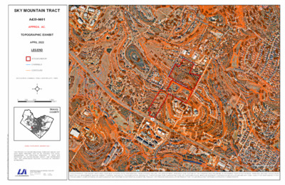
9429489169548949749681026936916960956910962908924990944978942940988992986926101495895690493092210421002900970932100410301006946918994103291492210069529789469981036100894410361010100093893410109568869789389329909569949501006898996888898948920936900924936100010329841006958100495293810129069289888949349909669129969189529489449161040924904972920972926934914906102289088610161002103010329869708969781034100296010101004916936958960984922942970946922964960924100898296210368849689221024103890890692010149029189729029049409769409289809349729881034976974962966998942906956962968958100896695095296093097096410109409449649269461032984942952956992948946898950918101297810309521012920990102893095497299491493491210281022992966962910968964100895210269369389869609281028103093092895010108881026954982102810189129481024102010169321006980976100210229741014100894294495292694495493694095094610009561024938958966960962968996964101297297093293410141008101810161020994101293493210109409429301004100289299810009969949929909369889869449849829389809769489781020974950972902101610149409529449549421018918956962964966960910908968958964960968962966970970948100691295095495699610049989941000972976982984980974978986990992988WILLIAMSONCREEK³±71MEDICINECREEKDROLDBEECAVESRDSUNSET RDGSKY MOUNTAIN DRMOUNTAIN SHADOWS DRCOVEREDBRIDGEDRTRAVISHILLSDRREHOBETHCIRSHUMARDOAKTRLCEDARELMTRLOLEANDERTRLTRAVIS COOK RDBELL DRMOUNTAINCRESTDRFORTBENTONDRCopyright nearmap 2015Path: K:\GIS\LJA Austin\Due Diligence Report\A439-0401\A439.0401.aprxTHE AUTHORS OF THIS EXHIBIT HAVE USED THEIR BEST EFFORTS IN ITS PREPARATION. THESE EFFORTS INCLUDE THE DEVELOPMENT, RESEARCH, AND TESTING OF THE THEORIES AND PROGRAMS TO DETERMINE THEIR EFFECTIVENESS. HOWEVER, NEITHER THE AUTHORSNOR THE U.S. GOVERNMENT NOR ANY AGENCY THEREOF, NOR ANY OF THEIR EMPLOYEES, NOR ANY OF THEIR CONTRACTORS, SUBCONTRACTORS, OR THEIR EMPLOYEES, MAKE ANY WARRANTY EXPRESS OR IMPLIED, OR ASSUME ANY LEGAL LIABILITY OR RESPONSIBILITY FORTHE ACCURACY, COMPLETENESS, OR USEFULNESS OF ANY INFORMATION APPARATUS, ALGORITHM, PRODUCT, OR PROCESS DISCLOSED, OR REPRESENT THAT ITS USE WOULD NOT INFRINGE ON PRIVATELY OWNED RIGHTS.THIS PRODUCT IS FOR INFORMATIONAL PURPOSES AND MAY NOTHAVE BEEN PREPARED FOR OR BE SUITABLE FOR LEGAL,ENGINEERING, OR SURVEYING PURPOSES. IT DOES NOTREPRESENT AN ON-THE-GROUND SURVEY AND REPRESENTSONLY THE APPROXIMATE RELATIVE LOCATION OF PROPERTYBOUNDARIES.AERIAL PHOTOGRAPH: NEARMAP 2022TRAVISCOUNTY05001,000250FEETDATA SOURCE: CHANNELS - FEMA, CONTOURS (2FT) - TNRISSITE BOUNDARYCHANNELSCONTOURSLEGENDAPRIL 2022TOPOGRAPHIC EXHIBITAPPROX. AC.A439-0401SKY MOUNTAIN TRACT1 of 5 EDWARDS AQUIFERCONTRIBUTING ZONEWILLIAMSONCREEK³±71MEDICINECREEKDROLDBEECAVESRDSUNSET RDGSKY MOUNTAIN DRMOUNTAIN SHADOWS DRCOVEREDBRIDGEDRTRAVISHILLSDRREHOBETHCIRSHUMARDOAKTRLCEDARELMTRLOLEANDERTRLTRAVIS COOK RDBELL DRMOUNTAINCRESTDRFORTBENTONDR¬«886¬«883¬«913¬«918¬«940¬«906¬«901¬«894¬«898Copyright nearmap 2015Path: K:\GIS\LJA Austin\Due Diligence Report\A439-0401\A439.0401.aprxTHIS PRODUCT IS FOR INFORMATIONAL PURPOSES AND MAY NOTHAVE BEEN PREPARED FOR OR BE SUITABLE FOR LEGAL,ENGINEERING, OR SURVEYING PURPOSES. IT DOES NOTREPRESENT AN ON-THE-GROUND SURVEY AND REPRESENTSONLY THE APPROXIMATE RELATIVE LOCATION OF PROPERTYBOUNDARIES.AERIAL PHOTOGRAPH DATE: NEARMAP 2022TRAVISCOUNTY05001,000250FTDATA SOURCE: FLOODPLAIN DATA - FEMA, EDWARDS AUIFER -TCEQ, EROSION BUFFER AREA, CEF BUFFER - CITY OFAUSTIN, GCW HABITAT OVERLAY - USFWSBFECHANNELS100 YEAR500 YEARZONE ASITE BOUNDARYEDWARDS AQUIFERCONTRIBUTING ZONEEROSION HAZARDBUFFER AREACRITICALENVIRONMENTFEATURE BUFFERLOW QUALITY GCWHABITATMEDIUM QUALITYGCW HABITATHIGH QUALITY GCWHABITATLEGENDAPRIL 2022ENVIRONMENTAL EXHIBITAPPROX. 22 AC.A439-0401SKY MOUNTAIN TRACT2 of 5 IR IR IR IR IR IR IR IR IR IR IR IR 5' INTERIOR SETBACK IR IR IR IR IR I R 5' INTERIOR SETBACK NUMBER MIN ELEV MAX ELEV COLOR I R I R 2 0 X E T E E H S E E S R I R I A 995 990 5 8 9 1+00 15' WL ESMT DOC. NO. __________ WATER QUALITY / DETENTION ESMT DOC. NO. __________ B 1+00 1+50 2+00 2+50 3+00 3+50 4+00 4+50 5+00 5+50 6+00 6+50 7+00 B IRRIGATION AREA B R I I R IR MOUNTAIN SHADOWS DR. . I R D N A T N U O M Y K S I R 15' STREET SIDE SETBACK I R IR IR IR IR I R I R IR IR PARKLAND ESMT. DOC. NO. __________ IRRIGATION AREA A WATER QUALITY / DETENTION …
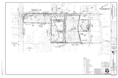
) W O R ' 0 5 1 ( 1 7 H S W N TIO C E S R E T IN 7 1 1 9 1 O F O F O F ZONING:AG-NP K C A B T E S ' 5 2 5 1 0 0 9 6 H F 6 0 0 0 9 6 3 1 0 0 9 6 N W O N K N U 2 0 2 4 2 N TIO C E S R E T IN N TIO C E S R E T IN N W O N K N U 4 7 2 4 3 2 0 8 2 4 3 2 1 8 2 4 3 2 5 8 2 4 3 2 6 8 2 4 3 2 H F O F O F O F ROW DEDICATION AND FUTURE MOUNTAIN SHADOWS DRIVE IMPROVEMENTS BY OTHERS ZONING: AG-NP INTERSECTION 11070 ZONING: MF-1-NP INTERSECTION 19650 MOUNTAIN SHADOWS DR. 226024 INTERSECTION 23376 INTERSECTION 9047 ZONING: MF-1-NP ZONING: MF-1-NP ZONING: RR-NP 25' BLDG SETBACK 25' BLDG SETBACK 15' STREET SIDE SETBACK LOT 1, BLOCK A MOUNTAIN CREST SUBDIVISION ZONING: LR-MU-NP S W O D A H S N A T N U O M I ZONING: MF-1 F-1 G: M NIN O Z F-1 G: M NIN O Z F-1 G: M NIN O Z 5' INTERIOR SETBACK F-1 G: M NIN O Z P R-N G: R NIN O Z K C A B T E S R O R E T N I I ' 5 ZONING: MF-1 N28°12'59"E 404.99' PROPOSED D.E. DOC. #____________ BY PLAT K C A B T E S R O I R E T N I 5' ZONING: MF-1 5' INTERIOR SETBACK ZONING: MF-1-NP ZONING:MF-1 ZONING: MF-1 . I R D N A T N U O M Y K S K C A B T E S R O R E T N I I ' 5 ' 5 0 . 5 2 3 ' W " 7 0 3 5 ° 1 6 N ' 1 0 . 5 2 5 ' W " 7 4 2 5 ° 1 6 N ' 2 9 . 4 2 3 ' E " 1 5 2 5 ° 1 6 S S28°14'30"W 399.04' N28°17'57"E 381.31' 5' INTERIOR SETBACK ZONING: MF-1-NP 5 ' I N T E R I O R S …
SUBDIVISION REVIEW SHEET CASE NO.: C8J-2008.0168.01.6A PC DATE: 7/12/2022 SUBDIVISION NAME: Entrada Phase 2 A Small Lot Subdivision AREA: 24.56 acres LOT(S): 139 OWNER/APPLICANT: AG Essential Housing Multi State 2, LLC. (Steven Benson) AGENT: Carlson, Brigance &Doering, Inc. (Brendan McEntee) ADDRESS OF SUBDIVISION: Entrada Tranquila Way GRIDS: Q-34, Q-35 COUNTY: Travis WATERSHED: Gilleland Creek JURISDICTION: 2-Mile ETJ EXISTING ZONING: N/A MUD: N/A PROPOSED LAND USE: Single Family ADMINISTRATIVE WAIVERS: N/A VARIANCES: None SIDEWALKS: Sidewalks will be provided on all internal streets. DEPARTMENT COMMENTS: The request is for approval with conditions of Entrada Phase 2 A Small Lot Subdivision consisting of 139 lots on 24.56 acres. Water and wastewater will be provided by the City of Austin. STAFF RECOMMENDATION: Staff recommends approval of the plat, subject to the conditions listed in the attached comment report. After the conditions are met, the plat will comply with City of Austin Land Development Code, Chapter 30-2-84(B). The conditions include plat note revisions, payment of parkland fees and a water quality plan. These are administrative actions that require no discretionary review. An application that has been approved with conditions may be updated to address those conditions until the application expires and the plat does not need to be heard before the Commission again. The plat has also been scheduled to be approved with conditions by the Travis County Commissioners Court at the July 12, 2022 meeting. ZONING AND PLATTING COMMISSION ACTION: CASE MANAGER: Sarah Sumner PHONE: 512-854-7687 1 1 of 13B-17 Email address: sarah.sumner@traviscountytx.gov 2 2 of 13B-17 CONSUMER PROTECTION NOTICE FOR HOMEBUYERS. IF YOU ARE BUYING A LOT IN THIS SUBDIVISION, YOU SHOULD DETERMINE WHETHER THE SUBDIVISION AND THE LAND AROUND IT ARE INSIDE OR OUTSIDE THE CITY LIMITS. THIS CAN AFFECT THE ENJOYMENT AND VALUE OF YOUR HOME. DEPENDING ON STATE LAW AND OTHER FACTORS, LAND OUTSIDE THE CITY LIMITS MAY BE SUBJECT TO FEWER LOCAL GOVERNMENT CONTROLS OVER THE DEVELOPMENT AND USE OF LAND THAN INSIDE THE CITY LIMITS. THE SUBDIVISION'S RESTRICTIVE COVENANTS MAY CREATE PRIVATELY ENFORCEABLE RESTRICTIONS AGAINST INCOMPATIBLE LAND USES WITHIN THE SUBDIVISION, WHETHER IT IS INSIDE OR OUTSIDE THE CITY LIMITS. DEPENDING ON STATE LAW AND OTHER FACTORS, HOWEVER OUTSIDE THE CITY LIMITS NEITHER PRIVATE NOR GOVERNMENTAL RESTRICTIONS MAY BE AVAILABLE TO (1) RESTRICT EITHER THE NATURE OR EXTENT OF DEVELOPMENT NEAR THE SUBDIVISION, OR (2) PROHIBIT LAND USES NEAR THE SUBDIVISION THAT ARE INCOMPATIBLE WITH A RESIDENTIAL NEIGHBORHOOD. …
Please accept this note as GEI’s formal request for postponement of zoning case C14-2022-0047 at 701 – 703 Highland Avenue. We would like to request to be postponed to the next available meeting, on July 26th. TO: City of Austin Planning Commission FROM: Steven Minor, P.E. DATE: July 11, 2022 Re: Zoning Case C14-2022-0047 Postponement Planning Commission Members, Thanks, Steven Minor, P.E. Gray Engineering, Inc. --- Consulting Engineers TBPELS Firm 2946 8834 N. Capital of Texas Highway, Suite 140 Austin, TX 78759 Phone: 512.452.0371 Fax: 512.454.9933
Good afternoon, Chairman Shaw and Commissioners – I am reaching out to ask that the Planning Commission postpone Item B-12 Flood Regulations to require that planning staff ensure 1. all federal and state floodplain management standards are met, 2. federal and state review procedures have been followed, 3. that the City will be fully compliant with all FEMA requirements so citizens can obtain federal flood insurance, and 4. to institutionally design governance checks and balances so that “director determination” does not risk establishing a de facto policy making process with a single point of influence. It is in all interests to postpone this proposed ordinance change to ensure engagement with all stakeholders and compliance with all federal and state regulations, statutes, and laws. Once finalized, outreach should be carried out to ensure that Austinites know LDC code changes will not put them in flooding danger or prevent them from buying affordable flood insurance. What is most troubling about this proposed ordinance change is Section A (1) and (2): § 25-7-93 GENERAL EXCEPTIONS. 4 (A) A development application with a proposed building or parking area that 5 encroaches on the 100-year floodplain may be approved if the encroachment is: (1) a parking area that is smaller than 5,000 square feet or an unoccupied structure that has an area of less than 1,000 square feet, and the director determines that the proposed development: (a) will not have an adverse effect on the 100-year floodplain or surrounding properties; and (b) otherwise complies with the requirements of this title; Without ensuring the first three concerns listed above are met, staff is not mitigating the peril that: • Austin will fail to meet FEMA requirements for citizens to be able to buy federally subsidized • Allow additional impervious cover that will potentially cause flooding downstream in the flood flood insurance, and plain. It was only last week that the proposed revised ordinance became available to the public. All that has been posted in Backup is last week’s ordinance draft and a slide deck. The slide deck makes no mention of carrying out policy analysis to ensure that concerns 1-3 above have been met. In the procedures followed section of the deck, there is no mention of when federal or state review will occur or recognition of federal and state stakeholders. There is no mention of SWOT analysis (Strengths, Weaknesses, Opportunities, Threats) having been done, much …
Planning Commission: June 28, 2022 NEIGHBORHOOD PLAN AMENDMENT REVIEW SHEET NEIGHORHOOD PLAN: Central West Austin Combined (Windsor Road) CASE#: NPA-2022-0027.01 PROJECT NAME: SHQ W 35th PC DATE: June 28, 2022 June 14, 2022 DATE FILED: February 6, 2022 (In-cycle) ADDRESS/ES: 1809 W. 35th Street DISTRICT AREA: 10 SITE AREA: 0.27 acs / 11,767 sq. ft. OWNER/APPLICANT: MEA Real Estate Ventures, LLC AGENT: Thrower Design, LLC (Ron Thrower and Victoria Haase) CASE MANAGER: Maureen Meredith STAFF EMAIL: Maureen.Meredith@austintexas.gov TYPE OF AMENDMENT: Change in Future Land Use Designation PHONE: (512) 974-2695 From: Neighborhood Commercial To: Neighborhood Mixed Use Base District Zoning Change Related Zoning Case: C14-2022-0021 From: LR-NP To: LO-MU-NP NEIGHBORHOOD PLAN ADOPTION DATE: September 23, 2010 CITY COUNCIL DATE: TBD PLANNING COMMISSION RECOMMENDATION: ACTION: 1 1 of 30B-1 Planning Commission: June 28, 2022 June 28, 2022 – June 14, 2022 – Postponed to June 28, 2022 on the consent agenda at the request of the neighborhood. [R. Schneider 1st; J. Thompson- 2nd] Vote: 9-0 [Y. Flores, C. Hempel, J. Mushtaler and J. Shieh absent]. STAFF RECOMMENDATION: Recommended BASIS FOR STAFF’S RECOMMENDATION: Staff supports the applicant’s request for Neighborhood Mixed Use land use to accommodate the inclusion of four residential units to the office use. The property is located with frontage on W. 35th Street, which is an activity corridor where mixed use developments are encouraged. The Central West Austin Neighborhood Plan supports small neighborhood-serving businesses and apartments. Objective 2: Preserve or enhance, as appropriate, existing multifamily housing and neighborhood-serving commercial districts. L.2.7 The residential scale and character along W. 35 th Street should be preserved, and in particular its existing building by building, horizontal collection of small neighborhood-serving businesses, stores, and apartments. Harmony with the abutting single-family houses on the south side of this block, facing 34th Street, should be maintained. Objective 3: All redevelopment should be compatible with the character of the adjacent neighborhood and should be guided by green design principles. (Note these are guidelines, not standards) LAND USE DESCRIPTIONS EXISTING LAND USE ON THE PROPERTY Neighborhood Commercial Lots or parcels containing small‐scale retail or offices, professional services, convenience retail, and shopfront retail that serve a market at a neighborhood scale. Purpose neighborhoods; and 1. Accommodate low‐intensity commercial services that serve surrounding 2. Encourage small‐scale retail within walking distance from residential areas. 2 2 of 30B-1 Application 1. Appropriate for areas such as minor arterials and collectors, small parcels …
ZONING CHANGE REVIEW SHEET SITE AREA: 0.27 acres DISTRICT: 10 ZONING TO: LO-MU-NP CASE: C14-2022-0021 -- SHQ @ W 35th ZONING FROM: LR-NP ADDRESS: 1809 West 35th Street PROPERTY OWNER: MEA Real Estate Ventures, LLC (Mehrdad Ebrahimi) AGENT: Thrower Design (Ron Thrower & Victoria Haase) CASE MANAGER: Heather Chaffin (512-974-2122) heather.chaffin@austintexas.gov STAFF RECOMMENDATION: Staff supports the applicant’s request of LO-MU-NP zoning. For a summary of the basis of staff’s recommendation, see case manager comments on page 2. PLANNING COMMISSION ACTION / RECOMMENDATION: June 28, 2022: June 14, 2022: To postpone to June 28, 2022 as requested by neighborhood, on consent. CITY COUNCIL ACTION: TBD ORDINANCE NUMBER: 1 of 9B-2 C14-2022-0021 Page 2 ISSUES: No issues at this time. CASE MANAGER COMMENTS: The subject property is located on the south side of West 35th Street between Oakmont Boulevard and Jefferson Street. The LR-NP zoned property is currently developed with a retail store and one residential unit. The residential use is not permitted in the current LR-NP zoning. Properties to the west are also zoned LR-NP and are developed with personal services and retail land uses. The lot immediately east of the property is also zoned LR-NP; the next 5 lots to the east are zoned LO-NP and the last lot on this block is zoned CS-NP. The LO-NP properties are developed with a mix of personal repair services, medical offices, multifamily and other uses. The CS-NP property is developed with financial services land use. South of the rezoning tract is a residential neighborhood zoned SF-3-NP. Across West 35th Street to the north are properties zoned LO, LR and MF-3 that are developed with personal services, retail, medical office, multifamily and retail land uses. Please refer to Exhibits A and B (Zoning Map and Aerial Exhibit). The applicant has stated that they are requesting the downzoning from LR to LO is because it would allow an additional 0.2 floor to area ratio (FAR). The FAR under LO would allow approximately 2,300 additional square feet of building square footage. The request of mixed use (MU) is because the existing residential use on the property is a currently a non- conforming land use and is not permitted by Code in LR zoning. The applicant has stated their intent to develop the property with residential and office land uses permitted in LO- MU-NP. Please refer to Exhibit C- Applicant Correspondence. Staff supports the rezoning request. …
City of Austin Housing and Plannin g Department P.O. Box 1088, Austin, TX 78767 -1088 (512) 974-3100 ♦ Fax (512) 974-3112 ♦ www .c ity o fau s tin .o rg/ h ou s in g MEMORANDUM TO: Todd W. Shaw, Chair & Planning Commission Members June 22, 2022 Maureen Meredith, Senior Planner, Inclusive Planning Division Heather Chaffin, Senior Planner, Current Planning Division Housing and Planning Department NPA-2022-0023.01.SH_5107, 5109, 5111, 5113, & 5115 Lancaster Ct. C14-2022-0018.SH_5107, 5109, 5111, 5113, & 5115 Lancaster Ct. University Hills/Windsor Park Neighborhood Planning Area FROM: DATE: RE: Staff requests a postponement of the above referenced cases from the June 28, 2022 Planning Commission hearing to the July 12, 2022 hearing date. Staff needs additional time to finalize the staff recommendation. The postponement request was made in a timely manner and meets the Planning Commission’s policy. Attachments: Zoning Map Plan Amendment Map The City of Austin is committed to compliance with the Americans with Disabilities Act and will provide reasonable modifications and equal access to communications upon request. 1 of 4B-3 The City of Austin is committed to compliance with the Americans with Disabilities Act and will provide reasonable modifications and equal access to communications upon request. 2 of 4B-3 The City of Austin is committed to compliance with the Americans with Disabilities Act and will provide reasonable modifications and equal access to communications upon request. 3 of 4B-3 The City of Austin is committed to compliance with the Americans with Disabilities Act and will provide reasonable modifications and equal access to communications upon request. 4 of 4B-3
City of Austin Housing and Plannin g Department P.O. Box 1088, Austin, TX 78767 -1088 (512) 974-3100 ♦ Fax (512) 974-3112 ♦ www .c ity o fau s tin .o rg/ h ou s in g MEMORANDUM TO: Todd W. Shaw, Chair & Planning Commission Members June 22, 2022 Maureen Meredith, Senior Planner, Inclusive Planning Division Heather Chaffin, Senior Planner, Current Planning Division Housing and Planning Department NPA-2022-0023.01.SH_5107, 5109, 5111, 5113, & 5115 Lancaster Ct. C14-2022-0018.SH_5107, 5109, 5111, 5113, & 5115 Lancaster Ct. University Hills/Windsor Park Neighborhood Planning Area FROM: DATE: RE: Staff requests a postponement of the above referenced cases from the June 28, 2022 Planning Commission hearing to the July 12, 2022 hearing date. Staff needs additional time to finalize the staff recommendation. The postponement request was made in a timely manner and meets the Planning Commission’s policy. Attachments: Zoning Map Plan Amendment Map The City of Austin is committed to compliance with the Americans with Disabilities Act and will provide reasonable modifications and equal access to communications upon request. 1 of 4B-4 The City of Austin is committed to compliance with the Americans with Disabilities Act and will provide reasonable modifications and equal access to communications upon request. 2 of 4B-4 The City of Austin is committed to compliance with the Americans with Disabilities Act and will provide reasonable modifications and equal access to communications upon request. 3 of 4B-4 The City of Austin is committed to compliance with the Americans with Disabilities Act and will provide reasonable modifications and equal access to communications upon request. 4 of 4B-4
MEMORANDUM ************************************************************************ TO: Planning Commission Members FROM: Sherri Sirwaitis Housing and Planning Department DATE: June 14, 2022 RE: C14-2021-0191 (Domain Central – 11500 Alterra Parkway) Postponement Request ************************************************************************ The staff would like to request an indefinite postponement of the above mentioned case. The staff is asking for this postponement to complete our review of this MI-PDA rezoning request. The postponement request was made in a timely manner and meets the Planning Commission’s policy. 1 of 1B-5
ZONING CHANGE REVIEW SHEET DISTRICT: 9 TO: SF-3 CASE: C14-2022-0057 – 1215 W Mary St. ZONING FROM: CS; SF-3 ADDRESS: 1215 W Mary Street SITE AREA: 0.2100 acres (9,148 square feet) PROPERTY OWNER: Bruce Riley AGENT: Permit Solutions, LLC (Crystal Lemus) CASE MANAGER: Michael Dietz; michael.dietz@austintexas.gov; (512) 974-7617 STAFF RECOMMENDATION: The Staff recommendation is to grant family residence (SF-3) district zoning. For a summary of the basis of Staff’s recommendation, see the Case Manager Comments section of this report. PLANNING COMMISSION ACTION / RECOMMENDATION: June 28, 2022 CITY COUNCIL ACTION: July 28, 2022 ORDINANCE NUMBER: ISSUES: None at this time. CASE MANAGER COMMENTS: The subject rezoning area consists of one platted lot, which is located near the middle of the block and currently zoned as general commercial services; family residence (CS; SF-3). The subject site is currently developed with a single-family residence, with a pergola and storage shed in the rear yard. Mary Street contains a broad range of residential and commercial uses, and intersects with a major arterial in South Lamar Boulevard to the west of the subject property. There are apartments to the west of the site (CS), a condominium community to the east and south, due to its unique lot shape (SF-6-CO), and an automotive repair use across the street (CS). Please refer to Exhibits A (Zoning Map) and A-1 (Aerial Exhibit). 1 of 9B-6 C14-2022-0057 Page 2 The applicant has requested family residence (SF-3) district zoning. Demolition of the existing structure has not been proposed at this time. The proposed rezoning would allow for the potential future development of one single-family residence, in addition to a second detached unit that would not exceed 1,100 square feet or a floor-to-area ratio of .15:1, whichever is smaller. The detached unit would be limited to two stories, or 30 feet, in height, and if a second story would be constructed for the unit, it would not be permitted to exceed 550 square feet in size. BASIS OF RECOMMENDATION: 1. The proposed zoning should be consistent with the purpose statement of the district sought. Zoning changes should promote compatibility with adjacent and nearby uses. The family residence (SF-3) district is the designation for a moderate density single-family residential use and a duplex use on a lot that is a minimum of 5,750 square feet. An SF-3 district designation may be applied to a use in an existing single-family neighborhood with …
ZONING CHANGE REVIEW SHEET TO: MF-2 DISTRICT: 3 CASE: C14-2022-0034 – South 3rd Street ZONING FROM: SF-3 ADDRESS: 400 feet south of the intersection of West Oltorf Street and South 3rd Street SITE AREA: 0.273 acres (11,892 square feet) PROPERTY OWNER: Third Street Austin LLC (Mark Whaling) AGENT: Metcalfe, Wolff, Stuart & Williams LLP (Michele R. Lynch) CASE MANAGER: Wendy Rhoades (512-974-7719, wendy.rhoades@austintexas.gov) STAFF RECOMMENDATION: The Staff recommendation is to grant multifamily residence – low density (MF-2) district zoning. The basis of Staff’s recommendation is provided on page 2. PLANNING COMMISSION ACTION / RECOMMENDATION: June 28, 2022: CITY COUNCIL ACTION: July 28, 2022: ORDINANCE NUMBER: ISSUES: The Applicant has discussed this case with representatives of the Galindo Elementary Neighborhood Association. CASE MANAGER COMMENTS: The subject unplatted, undeveloped tract is located south of a driveway that extends east to South 1st Street and intersects with South 2nd and South 3rd Streets to the north, both of which extend to Oltorf Street further north. The tract is zoned family residence (SF-3) district and has been purchased by the owner of the adjacent 6 unit apartment building to the west (MF- 2) which has driveway access to South 3rd Street. There are single family residences to the north and east, and private elementary and high school facilities, and a religious assembly use to the south (LO-CO; LO-V-CO; SF-3). Please refer to Exhibits A (Zoning Map) and A-1 (Aerial Exhibit). 1 of 12B-7 C14-2022-0034 Page 2 The Applicant has requested the multifamily residence – low density (MF-2) zoning district in order to facilitate redevelopment of the subject tract in conjunction with the abutting MF-2 tract to the west and build up to 18 residential units across both tracts. BASIS FOR RECOMMENDATION 1. The proposed zoning should be consistent with the purpose statement of the district sought. The multi-family residence – low density (MF-2) district is intended to accommodate multifamily use with a maximum density of 23 units per acre, depending on unit size and has a maximum height of 40 feet. This district is appropriate for multifamily residential areas located near single family neighborhoods or in an area for which low density multifamily use is desired. The Applicant’s proposal to prepare the tract for development of multifamily residences would be consistent with the purpose statement of the district sought. 2. Zoning changes should promote an orderly and compatible relationship among land uses. Based on …
ZONING CHANGE REVIEW SHEET DISTRICT: 3 CASE: C814-95-0001.02 – South Austin Medical Center ZONING FROM / TO: PUD-NP to PUD-NP, to change a condition of zoning ADDRESS: 901, 1001 West Ben White Boulevard, and 4210, 4214, 4300, 4302, 4304, 4306 James Casey Street SITE AREA: 17.30 acres PROPERTY OWNER: St. David’s Healthcare Partnership, LP, LLP (Mark Worsham) AGENT: Armbrust & Brown, PLLC (Michael Whellan) CASE MANAGER: Wendy Rhoades (512-974-7719, wendy.rhoades@austintexas.gov) STAFF RECOMMENDATION: The Staff recommendation is to grant an amendment to planned unit development (PUD) district zoning as shown in the Revised Zoning Exhibit for the Proposed Height Increase (Attachment A). For a summary of the basis of Staff’s recommendation, see pages 2 and 3. PLANNING COMMISSION ACTION: June 28, 2022: CITY COUNCIL ACTION: July 28, 2022: ORDINANCE NUMBER: ISSUES: The Southwood Neighborhood Association supports the proposed PUD amendment. Please refer to correspondence attached to the back of this Staff report. EXHIBITS AND ATTACHMENTS TO THE STAFF REPORT: Exhibits A and A-1: Zoning Map and Aerial Applicant’s Summary Letter and Revised Zoning Exhibit for the Proposed Height Increase (Attachment A) 1998 Amended Land Use Plan (Attachment B), and Original and Amended PUD Ordinances (Attachment C) 1 of 32B-8 C814-95-0001.02 Page 2 Correspondence Received CASE MANAGER COMMENTS: The South Austin Medical Center PUD is bounded by West Ben White Boulevard Eastbound Service Road and main lanes to the north, medical offices across James Casey Street to the east (LO-V-NP; LR-V-NP), medical offices to the south (GO-V-NP; LO-V-NP; LO-NP), and the Union Pacific Railroad tracks to the west. The PUD and surrounding properties to the east and south are located within the Hospital Special District established by the South Austin Combined (South Manchaca) Neighborhood Plan approved by Council in November 2014. Please refer to Exhibits A (Zoning Map) and A-1 (Aerial View). The PUD was approved by Council in June 1996 and is limited to uses allowed in the general office (GO) zoning district, along with hospital services (general) as an additional permitted use of the property, and established specific development standards including height (C814- 95-0001). The first amendment to the PUD was approved by Council in October 1998 and resulted in the addition of three adjacent lots along James Casey Street. The purpose of the PUD amendment is to facilitate the creation of additional capacity for more than 140 hospital beds. Specifically, the proposed PUD amendment would increase the allowable height …
ZONING CHANGE REVIEW SHEET PC DATE: June 28, 2022 CASE NUMBER: C14H-2022-0072 HLC DATE: May 4, 2022; June 1, 2022 APPLICANT: Historic Landmark Commission (owner-opposed) HISTORIC NAME: Carlson-Colunga House WATERSHED: Urban—Waller Creek ADDRESS OF PROPOSED ZONING CHANGE: 902 E. 7th Street ZONING CHANGE: TOD-NP to TOD-H-NP COUNCIL DISTRICT: 1 STAFF RECOMMENDATION: Staff recommends that the Historic Landmark Commission consider recommendation of the proposed zoning change from transit-oriented development-neighborhood plan (TOD-NP) to transit-oriented development-neighborhood plan-historic landmark (TOD-H-NP) combining district zoning. QUALIFICATIONS FOR LANDMARK DESIGNATION: The 2016 East Austin Historic Resource Survey recommends the property as eligible for designation as a local landmark for architecture and historical associations, individually eligible for listing in the National Register of Historic Places, and contributing to potential local and National Register historic districts. HISTORIC LANDMARK COMMISSION ACTION: May 4, 2022: initiate historic zoning based on architecture and historical associations (Koch, Little; 7-0). June 1, 2022: recommend historic zoning based on survey findings of architecture and historical associations (Koch, Valenzuela; 10-0). PLANNING COMMISSION ACTION: CASE MANAGER: Kalan Contreras NEIGHBORHOOD ORGANIZATIONS: Austin Independent School District, Austin Lost and Found Pets, Austin Neighborhoods Council, Del Valle Community Coalition, East Austin Conservancy, El Concilio Mexican-American Neighborhoods, Friends of Austin Neighborhoods, Greater East Austin Neighborhood Association , Guadalupe Association for an Improved Neighborhood, Guadalupe Neighborhood Development Corporation, Homeless Neighborhood Association, Neighborhood Empowerment Foundation, Neighbors United for Progress, Organization of Central East Austin Neighborhoods , Plaza Saltillo TOD Staff Liaison, Preservation Austin, SELTexas, Sierra Club, Austin Regional Group, Waterloo Greenway DEPARTMENT COMMENTS: The 2016 East Austin Historic Resource Survey recommends the property as eligible for designation as a local landmark, individually eligible for listing in the National Register of Historic Places and contributing to potential local and National Register historic districts. BASIS FOR RECOMMENDATION: § 25-2-352(3)(c)(i) Architecture. The property embodies the distinguishing characteristics of a recognized architectural style, type, or method of construction; exemplifies technological innovation in design or construction; displays high artistic value in representing ethnic or folk art, architecture, or construction; represents a rare example of an architectural style in the city; serves as an outstanding example of the work of an architect, builder, or artisan who significantly contributed to the development of the city, state, or nation; possesses cultural, historical, or architectural value as a particularly fine or unique example of a utilitarian or vernacular structure; or represents an architectural curiosity or one-of-a-kind building. CITY COUNCIL ACTION: PHONE: 512-974-2727 …
ZONING CHANGE REVIEW SHEET CASE NUMBER: C14H-2022-0071 HLC DATE: February 28, 2022; March 28, 2022; May 4, 2022; June 1, 2022 ADDRESS OF PROPOSED ZONING CHANGE: 1403 E. Cesar Chavez St. PC DATE: June 28, 2022 APPLICANT: Historic Landmark Commission (owner-opposed) HISTORIC NAME: Tofie and Bertha Balagia House WATERSHED: Urban—Lady Bird Lake NEIGHBORHOOD PLAN: East Cesar Chavez ZONING CHANGE: CS-1-MU-CO-NP to CS-1-MU-CO-H-NP COUNCIL DISTRICT: 3 STAFF RECOMMENDATION: Recommend the proposed zoning change from commercial liquor sales – mixed use – conditional overlay – neighborhood plan (CS-1-MU-CO-NP) to commercial liquor sales – mixed use – conditional overlay – historic landmark – neighborhood plan (CS-1-MU-CO-H-NP) combining district zoning. QUALIFICATIONS FOR LANDMARK DESIGNATION: Architecture and historical associations HISTORIC LANDMARK COMMISSION ACTION: June 1, 2022: recommend historic zoning based on survey findings of architecture and historical associations (Koch, Myers; 10-0). May 4, 2022: Postpone the public hearing. March 28, 2022: Postpone the public hearing at the owner’s request (Koch-Heimsath, 11-0). February 28, 2022: Initiate historic zoning based on architecture and historical associations and keep the public hearing open (Koch-Castillo, 10-0-1). PLANNING COMMISSION ACTION: CITY COUNCIL ACTION: CASE MANAGER: Kimberly Collins, 512-974-1801 NEIGHBORHOOD ORGANIZATIONS: Austin Independent School District, Austin Lost and Found Pets, Austin Neighborhoods Council, Del Valle Community Coalition, East Austin Conservancy, East Cesar Chavez IBIZ District, East Cesar Chavez Neighborhood Association, East Cesar Chavez Neighborhood Plan Contact Team, East Town Lake Citizens Neighborhood Association, El Concilio Mexican-American Neighborhoods, Friends of Austin Neighborhoods, Greater East Austin Neighborhood Association, Guadalupe Neighborhood Development Corporation, Homeless Neighborhood Association, Neighborhood Empowerment Foundation, Neighbors United for Progress, Preservation Austin, SELTexas, Sierra Club, Austin Regional Group, Tejano Town DEPARTMENT COMMENTS: The 2016 East Austin Survey report recommends that the property is eligible as a local landmark and contributes to a potential local historic district. BASIS FOR RECOMMENDATION: Architecture: The house embodies the distinguishing characteristics and is an excellent example of Craftsman-style architecture. It is of single-story residential construction with cross gable roofline built circa 1925. The roof has one triangular knee brace in the apex of each gable. The porch supports are composed of brick masonry piers with sloping sides. On top of the piers rest the decorative wooden support columns which appear to take cues from Orientalist design principles. The wooden porch railing is almost Stick in its patterned styling lending to the Western Stick reference known for some Craftsman styles. The structure has horizontal wood siding, and the …
SUBDIVISION REVIEW SHEET Total Plat Vacation CASE NO.: C8-71-51(VAC) Planning Commission DATE: June 28.2022 MUD: N/A LOT(S): 46 Lots COUNTY: Travis JURISDICTION: 2-Mile ETJ SUBDIVISION NAME: Linda Vista Subdivision – Total Plat Vacation AREA: 28.89 acres OWNER/APPLICANT: TSWG 130, LLC (John Gurasich) AGENT: Pape-Dawson Engineers, Inc. ADDRESS OF SUBDIVISION: FM 973 GRIDS: N/A WATERSHED: Onion and Dry E Creek EXISTING ZONING: N/A PROPOSED LAND USE: N/A ADMINISTRATIVE WAIVERS: None VARIANCES: None SIDEWALKS: N/A DEPARTMENT COMMENTS: The request is for approval of a total plat vacation of the Linda Vista Subdivision final plat consisting of 46 lots on 28.89 acres. The vacation will take this to raw land. COUNTY COMMENTS This property is located in the 2-Mile, ETJ (Extra-Territorial Jurisdiction) of the City of Austin. The Texas Local Government prohibits the city and the county from regulating land uses, lot size, density, height and building coverage in the ETJ to name a few. ISSUES: Staff has not received any inquiries from anyone on this plat vacation. STAFF RECOMMENDATION: As this final plat vacation meets all Title 30 requirements; staff recommends approval. 1 of 4B-14 ZONING AND PLATTING COMMISSION ACTION: CASE MANAGER: Jose Luis Arriaga Email address: joe.arriaga@traviscountytx.gov PHONE: 512-854-7562 2 of 4B-14 3 of 4B-14 4 of 4B-14
CASE NO.: C8J-2021-0154.0A SUBDIVISION REVIEW SHEET Planning Commission DATE: June 28.2022 MUD: N/A LOT(S): 8 Lots COUNTY: Travis JURISDICTION: 2-Mile ETJ SUBDIVISION NAME: Majestic Decker Lane - Final Plat AREA: 79.96 acres OWNER/APPLICANT: Majestic Timmermann LLC AGENT: Kimley-Horn and Associates, Inc. (Luke Caraway) ADDRESS OF SUBDIVISION: Decker Lane GRIDS: N/A WATERSHED: Decker Creek EXISTING ZONING: N/A PROPOSED LAND USE: N/A ADMINISTRATIVE WAIVERS: None VARIANCES: None SIDEWALKS: N/A DEPARTMENT COMMENTS: The request is for approval of a final plat consisting of 8 total non-residential lots on 79.96 acres. The proposed subdivision will take access from Decker Lane and is located in the city’s 2-Mile ETJ. Water and wastewater will be provided by City of Austin. The development does not plan for any residential uses at this time. COUNTY COMMENTS This property is located in the 2-Mile, ETJ (Extra-Territorial Jurisdiction) of the City of Austin. The Texas Local Government prohibits the city and the county from regulating land uses, lot size, density, height and building coverage in the ETJ to name a few. ISSUES: Staff has not received any inquiries from anyone on this proposed subdivision STAFF RECOMMENDATION: As this final plat meets all Title 30 requirements; staff recommends approval. 1 of 7B-15 ZONING AND PLATTING COMMISSION ACTION: CASE MANAGER: Jose Luis Arriaga Email address: joe.arriaga@traviscountytx.gov PHONE: 512-854-7562 2 of 7B-15 VICINITY MAP OPRTC NORTH NOT TO SCALE ACCESS EASEMENT DOC# 2021101898 OPRTC 44.90' IRSC F 4 F 4 T 2 O T 1 O E E H S E E H S 26.44' (45' WIDE) JOINT ACCESS EASEMENT DOC# 2021089381 OPRTC 18.56' OHE S79°54'56"E 951.34' OHE ' 9 7 . 9 PERMANENT ACCESS EASEMENT DOC# 2021101898 OPRTC OHE 905.67' (30.50') WATER LINES AND WASTEWATER LINES EASEMENT DOC# 2021221195 OPRTC 954.73' S79°54'56"E 1094.09' OHE ' 0 5 . 2 7 OHE EXISTING ELECTRIC TRANSMISSION LINE WITH ELECTRIC UTILITY EASEMENT VOL. 12782, PG.0687 RPRTC ' 0 8 . 0 5 1 LOT 8 OHE BLOCK A IRSC CITY OF AUSTIN WIDTH (PRIVATE) CITY OF AUSTIN REGULATORY FLOODPLAIN 1/2" IRFC 139.36' OHE IRSC OHE IRSC 0' 0.0 7 45.67' QUITCLAIM DEED FROM SOUTHERN PACIFIC TRASPORTATION COMPANY TO CITY OF AUSTIN VOL.9870, PG.877 DRTC T.B.M.#101 OHE OHE C1 OHE IRSC OHE S62°08'17"E N62°08'15"W 235.38' 240.34' 382.15' LOT 5 20.056 ACRES 873,639 SQ. FT. BLOCK A MIN. F.F.E. 581' M.S.E. EXCLUSIVE WATER LINES VAULT EASEMENT DOC# 2021221194 OPRTC (45' WIDE) JOINT ACCESS EASEMENT DOC# 2021089381 OPRTC …