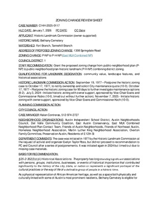
ZONING CHANGE REVIEW SHEET CASE NUMBER: C14H-2025-0117 HLC DATE: January 7, 2026 PC DATE: CC Date: APPLICANT: Historic Landmark Commission (owner-supported) HISTORIC NAME: Bethany Cemetery WATERSHED: Fort Branch, Tannehill Branch ADDRESS OF PROPOSED ZONING CHANGE: 1308 Springdale Road ZONING CHANGE: P-NP to P-H-NP (East MLK Combined NP) COUNCIL DISTRICT: 1 STAFF RECOMMENDATION: Grant the proposed zoning change from public-neighborhood plan (P- NP) to public-neighborhood plan-historic landmark (P-H-NP) combining district zoning. QUALIFICATIONS FOR LANDMARK DESIGNATION: community value, landscape features, and historical associations HISTORIC LANDMARK COMMISSION ACTION: September 19, 1977 – Postpone the historic zoning case to October 17, 1977, to notify ownership and solicit City maintenance quote (10-0). October 17, 1977 – Postpone the historic zoning case for 90 days to further investigate maintenance options (8-2). July 3, 2024 – Initiate historic zoning with owner support, sponsored by Vice-Chair Evans and Commissioner Rubio (10-0, timed out without further action). November 7, 2025 - Initiate historic zoning with owner support, sponsored by Vice-Chair Evans and Commissioner Koch (10-0). PLANNING COMMISSION ACTION: CITY COUNCIL ACTION: CASE MANAGER: Kalan Contreras, 512-974-2727 NEIGHBORHOOD ORGANIZATIONS: Austin Independent School District, Austin Neighborhoods Council, Del Valle Community Coalition, East Austin Conservancy, East MLK Combined Neighborhood Plan Contact Team, Friends of Austin Neighborhoods, Friends of Northeast Austin, Homeless Neighborhood Association, Martin Luther King Neighborhood Association, Overton Family Committee, Preservation Austin, Residents of E 12th St DEPARTMENT COMMENTS: The case was initiated in 1977 by the Historic Landmark Commission at the request of activist and organizer Evelyn Taylor Ross, but did not proceed to recommendation to PC and Council after a series of postponements. It was initiated again in 2024 but timed out due to missing case materials. BASIS FOR RECOMMENDATION: § 25-2-352(3)(c)(ii) Historical Associations. The property has long-standing significant associations with persons, groups, institutions, businesses, or events of historical importance that contributed significantly to the history of the city, state, or nation or represents a significant portrayal of the cultural practices or the way of life of a definable group of people in a historic time. As a physical representation of African American heritage, as well as a space both physically and culturally linked with some of Austin’s most prominent residents, Bethany Cemetery is eligible for designation as a City of Austin historic landmark. Historian Emily Payne describes the cemetery’s importance in her 2025 narrative: The individuals associated with Bethany Cemetery include the founders of the Bethany Cemetery Company, …
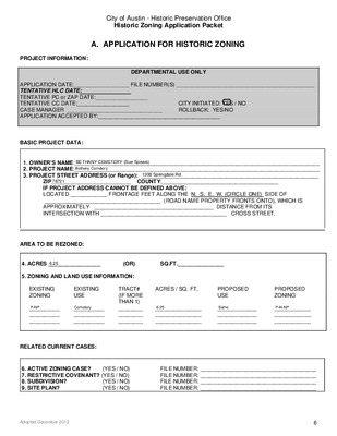
City of Austin - Historic Preservation Office Historic Zoning Application Packet A. APPLICATION FOR HISTORIC ZONING PROJECT INFORMATION: DEPARTMENTAL USE ONLY APPLICATION DATE:__________________ FILE NUMBER(S) _____________________________________________ TENTATIVE HLC DATE: TENTATIVE PC or ZAP DATE:_________________ TENTATIVE CC DATE:_________________ CASE MANAGER _______________________________ APPLICATION ACCEPTED BY:________________________________________ CITY INITIATED: YES / NO ROLLBACK: YES/NO BASIC PROJECT DATA: 1. OWNER’S NAME:________________________________________________________________________________ 2. PROJECT NAME:________________________________________________________________________________ 3. PROJECT STREET ADDRESS (or Range): __________________________________________________________ ZIP__________________________ COUNTY:______________________________________ IF PROJECT ADDRESS CANNOT BE DEFINED ABOVE: LOCATED ____________ FRONTAGE FEET ALONG THE N. S. E. W. (CIRCLE ONE) SIDE OF ______________________________________ (ROAD NAME PROPERTY FRONTS ONTO), WHICH IS APPROXIMATELY _______________________________________ DISTANCE FROM ITS INTERSECTION WITH _________________________________________ CROSS STREET. AREA TO BE REZONED: 4. ACRES _________________ (OR) SQ.FT._______________ 5. ZONING AND LAND USE INFORMATION: EXISTING ZONING EXISTING USE __________ __________ __________ __________ __________ __________ TRACT# (IF MORE THAN 1) ________ ________ ________ ACRES / SQ. FT. PROPOSED USE PROPOSED ZONING _______________ _______________ _______________ _____________ _____________ _____________ ____________ ____________ ____________ RELATED CURRENT CASES: (YES / NO) 6. ACTIVE ZONING CASE? 7. RESTRICTIVE COVENANT? (YES / NO) (YES / NO) 8. SUBDIVISION? (YES / NO) 9. SITE PLAN? FILE NUMBER: ______________________________________ FILE NUMBER: ______________________________________ FILE NUMBER: ______________________________________ FILE NUMBER: ______________________________________ Adopted December 2012 6 BETHANY CEMETERY (Sue Spears)Bethany Cemetery1308 Springdale Rd.787216.25P-NPCemetery6.25SameP-H-NP City of Austin - Historic Preservation Office Historic Zoning Application Packet C: Tax Certificate Adopted December 2012 Page C-1 City of Austin - Historic Preservation Office Historic Zoning Application Packet John M. Holland was born around 1850 in Marshall, Texas.2 By 1880, census records indicate that he was working as a farmer in rural Travis County. By 1900, John M. Holland and his family lived in Austin at 1409 San Bernard Street (house no longer extant), and he was working as a sexton at a church.3 Other sources indicate that John M. Holland also worked as a real estate agent.4 By 1920, John M. Holland and his family lived at present-day 1193 ½ San Bernard Street (then addressed as 1189 San Bernard Street).5 William H. Holland—likely the brother of John M. Holland—was born around 1849 in Marshall, Texas.6 William H. Holland went on to become “the superintendent of the Deaf, Dumb and Blind Institute for Colored Youths of Texas.”7 By 1889, city directories indicate that he lived “about 2 ½ miles northwest” of downtown Austin, “north of Mt. Bonnell road.”8 Additional biographical detail regarding William Holland is quoted below: In 1849, …
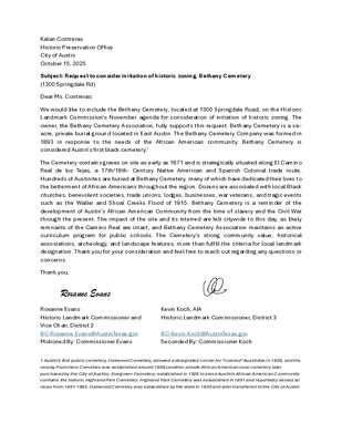
Kalan Contreras Historic Preservation Office City of Austin October 15, 2025 Subject: Request to consider initiation of historic zoning, Bethany Cemetery (1300 Springdale Rd) Dear Ms. Contreras: We would like to include the Bethany Cemetery, located at 1300 Springdale Road, on the Historic Landmark Commission’s November agenda for consideration of initiation of historic zoning. The owner, the Bethany Cemetery Association, fully supports this request. Bethany Cemetery is a six- acre, private burial ground located in East Austin. The Bethany Cemetery Company was formed in 1893 in response to the needs of the African American community. Bethany Cemetery is considered Austin’s first black cemetery.1 The Cemetery contains graves on site as early as 1871 and is strategically situated along El Camino Real de los Tejas, a 17th/18th- Century Native American and Spanish Colonial trade route. Hundreds of Austinites are buried at Bethany Cemetery, many of which have dedicated their lives to the betterment of African Americans throughout the region. Dozens are associated with local Black churches, benevolent societies, trade unions, lodges, businesses, war veterans, and tragic events such as the Waller and Shoal Creeks Flood of 1915. Bethany Cemetery is a reminder of the development of Austin’s African American Community from the time of slavery and the Civil War through the present. The impact of the site and its interred are felt citywide to this day, as likely remnants of the Camino Real are intact, and Bethany Cemetery Association maintains an active curriculum program for public schools. The Cemetery’s strong community value, historical associations, archeology, and landscape features, more than fulfill the criteria for local landmark designation. Thank you for your consideration and feel free to reach out regarding any questions or concerns. Thank you, Roxanne Evans Roxanne Evans Historic Landmark Commissioner and Vice Chair, District 2 BC-Roxanne.Evans@AustinTexas.gov Motioned By: Commissioner Evans Kevin Koch, AIA Historic Landmark Commissioner, District 3 BC-Kevin.Koch@AustinTexas.gov Seconded By: Commissioner Koch 1 Austin’s first public cemetery, Oakwood Cemetery, allowed a designated corner for “colored” Austinites in 1856, and the nearby Plummers Cemetery was established around 1898 (another private African American rural cemetery later purchased by the City of Austin). Evergreen Cemetery, established in 1926 to serve Austin’s African American Community contains the historic Highland Park Cemetery. Highland Park Cemetery was established in 1891 and reportedly served all races from 1891-1893. Oakwood Cemetery was established by the state in 1839 and later transferred to the City of Austin …
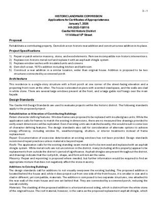
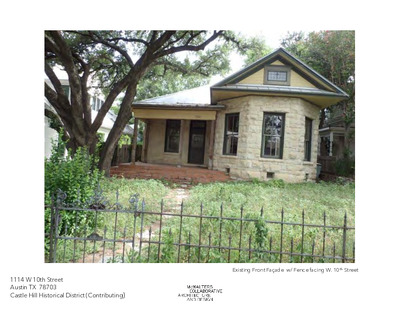
HISTORIC LANDMARK COMMISSION Applications for Certificates of Appropriateness January 7, 2026 HR-2025-158116 Castle Hill Historic District 1114 West 10th Street 3 – 1 Proposal Rehabilitate a contributing property. Demolish a non-historic rear addition and construct a new addition in its place. Project Specifications 1) Repair or patch exterior masonry, stone, and wood elements. Remove incompatible non-historic interventions. 2) Replace non-historic metal roof and replace it with an asphault shingle system. 3) Replace window sashes with insulated units and screens 4) Demolish a rear, 1970s addition including kitchen and bathroom. 5) Construct a rear addition in a similar location, wider than original house. Addition is proposed to be two structures connected by a screened porch. Architecture This residence is a single-story structure with a front porch at one corner of the street-facing elevation and a projecting front room at the other. The house is elevated on piers with a vented crawlspace, and the walls are clad in white stone. There are several large windows present at the front, and a large gable roof hangs over the main façade. Design Standards The Castle Hill Design Standards are used to evaluate projects within the historic district. The following standards apply to the proposed project: Rehabilitation or Alteration of Contributing Buildings Retain character defining features: Window frames are proposed to be replaced with insulted glass units. While the application calls for frames to match the existing in dimensions, there are no measured line drawings provided to verify exact dimensions will be replicated. Even if existing units are matched exactly, this would result is some loss of character defining features. The design standards also call for consideration of alternate options to achieve energy efficiency, including window fil,, weatherstripping, shutters, or interior treatments instead of frame replacement. Repair: Documentation of excessive deterioration at existing windows has not been provided. Design standards recommend repair practices unless material is beyond repair. Roofs: The application calls for the existing standing-seam metal roof to be removed and replaced with an asphalt shingle system. While metal roofs are not uncommon in the district, many (including at this property) appear to be replacements from outside the district’s period of significance. Asphalt shingles are present throughout the district, and drawings indicate that the roof pitch, shape, and form will remain the same. Masonry: Repair and repointing is proposed where needed, but further information would be required to find an appropriate mixture that does …
1114 W 10th Street Austin TX 78703 Castle Hill Historical District (Contributing) Existing Front Façade w/ Fence facing W. 10th Street 1114 W 10th Street Austin TX 78703 Castle Hill Historical District (Contributing) Existing (Not Original, estimated 1970s)) Front Porch facing W 10th St. Existing (Original) Front Door with Transom at Front Porch Existing (Original) Door Opening and Transom; Replacment Door at Side Elevation of Front Porch 1114 W 10th Street Austin TX 78703 Castle Hill Historical District (Contributing) Existing (estimated 1970s ?) Rear Addition 1114 W 10th Street Austin TX 78703 Castle Hill Historical District (Contributing) Existing (estimated 1970s ?) Rear Addition 1114 W 10th Street Austin TX 78703 Castle Hill Historical District (Contributing) Existing (Original) Limestone, Window, Eave, Soffit and Trim 1114 W 10th Street Austin TX 78703 Castle Hill Historical District (Contributing) Existing (Original) Limestone, Window, Eave, with Porch Addition 1114 W 10th Street Austin TX 78703 Castle Hill Historical District (Contributing) (P) T-3 T-2 T-1 9 7 T-7 8 7 T-7 6 7 T-7 7 7 T-7 5 7 T-7 A Existing Site Plan Scale: as noted 4 7 T-7 (H) PROJECT NORTH TRUE NORTH (P) T-3 T-2 T-1 EXTG AC PAD NEW AC PAD CAT WINE TRASH N D WASH DRY MECH ACCESS ABOVE REF DW TRASH MICRO 4 7 T-7 (H) 74.6" W 192.5" L 71.6" H P U P M A R SLOPE UP 8.5' x 17' MIN SPACE 74.6" W 192.5" L 71.6" H 8.5' x 17' MIN SPACE NEW GENERATOR PAD 6 7 T-7 7 7 T-7 B Proposed Site Plan Scale: as noted PROJECT NORTH TRUE NORTH SITE PLANS EXISTING / PROPOSED Sketch No. sk-SCHELL-HLC-Rvw-site-plans-S01 Project Name The Schell Residence 1114 West 10th Street Austin, TX 78703 Date: Scale: Ref: 11 DEC 2025 1/8" = 1'-0" ROSE COPYRIGHT McWALTERS COLLABORATIVE 2025 McWALTERS COLLABORATIVE ARCHITECTURE AND DESIGN 1604 Nueces Street Austin, TX 78701 21'-0" EX CARPORT 12'-3 5/8" EX SHED / GUEST 10'-4 1/4" EX BREEZEWAY 20'-3 1/2" EX ADDITION 40'-9 1/4" EX STONE HOUSE " 2 / 1 6 - ' 6 K L A W D E R E V O C X E " 0 - ' 8 1 T R O P R A C X E SHED CARPORT GUEST " 4 / 3 0 - ' 3 X E D E H S " 3 - ' 3 X E " 0 - ' 8 2 …
HISTORIC LANDMARK COMMISSION Applications for Certificates of Appropriateness January 7, 2026 HR-2025-158169 Confederate Woman’s Home 3710 Cedar Street 4 – 1 Proposal Construct two courtyard additions at a City of Austin landmark. Project Specifications 1) At the interior courtyard, construct a two-story addition behind the main structure of the Confederate Women’s Home. 2) Construct a rear addition at the rear, Home Ln. facing service structure. 3) Replace windows as required due to failure or deterioration. Design Standards The City of Austin’s Historic Design Standards (March 2021) are based on the Secretary of the Interior’s Standards for Rehabilitation and are used to evaluate projects at historic landmarks. The following standards apply to the proposed project: Repair and alterations 5. Windows, doors, and screens The application states that windows and some doors will be replaced on the main building, but detail drawings or a window schedule have not been provided, so the amount of replacements proposed, as well as the existing conditions, cannot be commented on at this time. Residential additions 1. Location Bothadditions are to be located at the rear of their respective buildings. The main building faces Cedar Street and West 38th Street, and the rear heating plant/storage facility faces Home Lane. However, due to the narrow block layout of the site, as well as the two buildings forming an incomplete loop, both rear additions will be visible from the street. 2. Scale, massing, and height The addition to the main building will be two stories in height, and the addition at the heating/storage building will be mostly a single-story with some second floor buildout. The massing of the living space is generally acceptable, but the proposed roof at the main addition will extend the overall roofline above the existing and will create visibility issues at Cedar Street and possibly West 38th Street. Due to this being a landamrked building, this visual interruption would not meet Standard 2.2. The massing at the heating/storage building is less of a concern given the utilitarian nature of the structure and numerous changes that have occurred at that location. 3. Design and style Additions are generally simple in design and deferantial to the historic buildings. However, details such as the height ot the roof peaks and potential incompatible stone cladding on the first floor may create a visually clashing appearance when placed next to the historic age building, which is clad in destinctive clad …
W 3 7 T H S T R E E T 6" PVC T 6" VC D T E E R T S H T 5 3 W 6 " V C 6 " C I 6 " C I ) . 6" DI W VAN . W O R . ' 0 6 ( 6 " C I 6 " V C 6 " V C I I F R E R S E R R O O M D 6 " C I 8 " C I A L L E Y W A Y 8 " C I Portion of site with H designation. Existing buildings shown with any extensions G HOME LANE (R.O.W. VARIES) 00 20' 40' GRAPHIC SCALE 20' LEGEND PROPERTY LINE PROPOSED EASEMENT ROW DEDICATION FIRE LANE PROPOSED WALL BUILDING NUMBER BUILDING TYPE X TYPE X 0 5 1 E T U S I , 2 1 3 G N D L I U B I , D A O R N O S E L R U B 0 0 8 6 4 4 7 8 7 X T , I N T S U A 2 4 9 9 - 6 1 6 - 2 1 5 : E N O H P ( 1 5 ' . R O W . . ) G BLDG 2 BLDG 2 ADDITION . - M O C N R O H Y E L M K W W W I . . C N I , I S E T A C O S S A D N A N R O H Y E L M K 5 2 0 2 - I C Y B E T A D I S N O S V E R I . o N 8 2 9 . o N m r i F E P B T VAN BLDG 1 ADDITION W W W BLDG 1 ADDITION BLDG 1 CEDAR STREET (R.O.W. VARIES) T E E R T S H T 8 3 W ) I S E R A V . . W O R . ( 10/9/2025 T C E J O R P A H K 2 1 3 9 7 2 9 6 0 E T A D 5 2 0 2 R E B O T C O N W O H S S A : E L A …
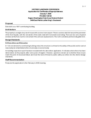
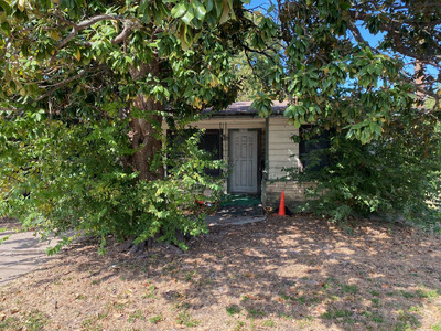
HISTORIC LANDMARK COMMISSION Application for Certificates of Appropriateness January 7, 2026 PR-2025-144142 Rogers Washington Holy Cross Historic District 2406 East Martin Luther King Jr. Boulevard 5 – 1 Proposal Demolish a ca. 1957 contributing building. Architecture The property is a single story ranch house with a corner inset carport. There is a stone clad skirt around the perimeter of the front façade, with the remainder of the walls clad with horizontal wood siding. There are two sets of paired windows at the front, but it is not certain if the units are replacements. The roof is a shallow pitched side gable form. Design Standards 9.0 Demolition and Relocation 9.1: Do not demolish a contributing building unless the structure is a threat to the safety of the public and/or cannot reasonably be rehabilitated either structurally or economically. An building inspection report has been included with this demolition application. It indicates where there has been deterioration at the property after some years of neglect. However, questions remain as to whether these issues reach the point of structural failure and meet the level of threat to public safety as written into the district design standards. Staff Recommendation Postpone the application to the February 4, 2026 meeting. Location Map 5 – 2 Property Information Photos 5 – 3 Demolition application, 2025 5 – 4 Aerial imagery, 1958 (top), and 1965 (bottom): note the building at 2406 E Martin Luther King Blvd (then 19th St.) at the left of the block between Maple Ave. and Cedar Ave. in the 1958 image. Occupancy History City Directory Research, November 2025 1960 1959 Benjamin Leslie Armstrong, renter; laboratory worker at the State Department of Health Address not listed Historical Information 5 – 5 Meeting minutes of Austin City Council, January 13, 1944. Marker for Benjamin Leslie and Sallie Ann Armstrong, Evergreen Cemetery Permits 5 – 6 Water service permit, 1959. City records indicate a sewer permit from the same year but no image is available.
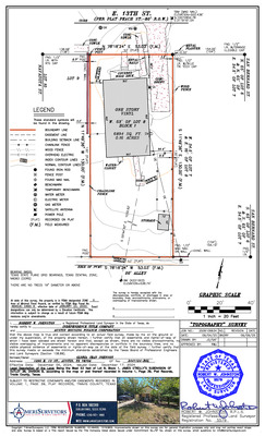
' . 0 0 1 LOT 16 UTILITY POLE N 80° 49' 00" E 101.40' ' 3 1 . LOT 15 LOT 14 ' 5 0 . 560 5' DRAINAGE, AERIAL OVERHANG, PUBLIC UTILITY EASEMENT 1/2" IRF ' 5 0 . CM 1/2" IRF 0.4' 562 561 8.1' 1 2 . 3 ' METAL SHED 7" HACKBERRY 10" MULTI-TRUNK HACKBERRY 0 6 5 ' 9 . 5 1 10.0' METAL SHED (NO FOUNDATION) WASHINGTON SUBDIVISION VOL. 9, PG. 121 P.R.T.C.T. 1.1' 9" ELM 1 6 5 10.8' ' 1 0 . 0 2 1 W " 0 0 ' 1 3 ° 8 0 N LOT 1 HOLY CROSS HEIGHTS 9 5 5 35.5' FINISHED FLOOR = 561.45' ' 3 . 4 1 EM ' 1 . 7.3' 4 3.8' ONE STORY FRAME RESIDENCE 2406 E. MARTIN LUTHER KING JR. BOULEVARD ' 4 . 4 3 560 ' 1 . 0 2 12.1' ' 1 . 4 12.3' 15" MULTI-TRUNK ELM 561 GUY ANCHORS 5 6 0 CLEANOUT 1/2" IRF TELE. VAULT UTILITY POLE 10.0' 559 9" SUGARBERRY SS STORM SEWER MANHOLE 5' PUBLIC UTILITY EASEMENTS LOT 2 E N I L T O L L A N G R O I I 558 12,252 SQ. FT. 0.281 AC. CLEANOUT GM UTILITY POLE ' . 0 0 0 2 1 E " 0 0 ' 1 1 LOTS 3 AND 4 2414 E. MLK CONDOMINIUMS DOC. NO. 2017065463 P.R.T.C.T. 0.5' 23" MULTI-TRUNK WHITEOAK ° 9 0 S 10' DRAINAGE & PUBLIC UTILITY EASEMENTS 55.5' 25' BUILDING LINE 20.0' ' 1 . 5 2 27" MAGNOLIA 5 5 9 GUY ANCHOR GUY ANCHOR 558 FOUND 5/8" SQUARE BOLT S 80° 49' 00" W 102.80' (REFERENCE BEARING) SS SANITARY SEWER MANHOLE WATER METER W LIGHT POLE STORM SEWER MANHOLE SS 1/2" IRF N 80° 49' 00" E 114.18' INLET SS CM 1/2" IRF P.C. OF LOT 8 N 80° 49' 00" E 205.54' E. MARTIN LUTHER KING JR. BOULEVARD (EAST 19TH STREET PER PLAT) (60' R.O.W.) TBM SET MAG NAIL ELEV. = 558.91' LEGEND: BARBWIRE FENCE CHAINLINK FENCE WROUGHT IRON FENCE WOOD FENCE VINYL FENCE ELECTRIC LINE ASPHALT = CONCRETE = GRAVEL = TILE = WOOD = GM = GAS METER EM = ELECTRIC METER IPF = IRON PIPE FOUND IRS = IRON ROD SET WITH "PREMIER" CAP IRF = IRON ROD FOUND CM = CONTROLLING MONUMENT (WOOD) RAILROAD TIE = STONE …
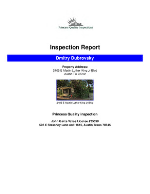
Inspection Report Dmitry Dubrovsky Property Address: 2406 E Martin Luther King Jr Blvd Austin TX 78702 2406 E Martin Luther King Jr Blvd Princess Quality inspection John Garza Texas License #25098 505 E Stassney Lane unit 1616, Austin Texas 78745 PROPERTY INSPECTION REPORT FORM Dmitry Dubrovsky Name of Client 2406 E Martin Luther King Jr Blvd, Austin, TX 78702 Address of Inspected Property John Garza Name of Inspector 10/23/2025 Date of Inspection Texas License #25098 TREC License # Name of Sponsor (if applicable) TREC License # PURPOSE OF INSPECTION A real estate inspection is a visual survey of a structure and a basic performance evaluation of the systems and components of a building. It provides information regarding the general condition of a residence at the time the inspection was conducted. It is important that you carefully read ALL of this information. Ask the inspector to clarify any items or comments that are unclear. RESPONSIBILTY OF THE INSPECTOR This inspection is governed by the Texas Real Estate Commission (TREC) Standards of Practice (SOPs), which dictates the minimum requirements for a real estate inspection. The inspector IS required to: • use this Property Inspection Report form for the inspection; • • • inspect only those components and conditions that are present, visible, and accessible at the time of the inspection; indicate whether each item was inspected, not inspected, or not present; indicate an item as Deficient (D) if a condition exists that adversely and materially affects the performance of a system or component OR constitutes a hazard to life, limb or property as specified by the SOPs; and • explain the inspector’s findings in the corresponding section in the body of the report form. The inspector IS NOT required to: identify all potential hazards; turn on decommissioned equipment, systems, utilities, or apply an open flame or light a pilot to operate any appliance; • • • climb over obstacles, move furnishings or stored items; • prioritize or emphasize the importance of one deficiency over another; • provide follow-up services to verify that proper repairs have been made; or • inspect system or component listed under the optional section of the SOPs (22 TAC 535.233). RESPONSIBILTY OF THE CLIENT While items identified as Deficient (D) in an inspection report DO NOT obligate any party to make repairs or take other actions, in the event that any further evaluations are needed, it is the …
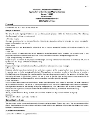
HISTORIC LANDMARK COMMISSION Application for Certificates of Appropriateness January 7, 2026 SB-2025-158077 Red River International House 3805 Red River Street 6 – 1 Proposal Construct a sign at a City of Austin landmark. Design Standards The City of Austin Signage Guidelines are used to evaluate projects within the historic district. The following standards apply to the proposed project: 1. Number of signs One sign is proposed at the corner of the lot. Historic sign guidelines allow for one sign per street frontage for properties located on a corner lot. 2. Sign types Freestanding signs are allowable for office/retail use in historic residential buildings, which is applicable for this property. 3. Sign size Current historic signage guidelines do not address size of freestanding signs. However, the size and scale of this proposal does not overwhelm the historic structure, nor does it limit views of neighboring properties. 4. Sign design, coloring and materials Simple shapes and materials are proposed for this sign. Coloring is limited to three colors, and is heavily influenced by the color and design of the landmarked building. 5. Lettering Proposed lettering is limited to two typefaces, and neither is too contemporary in design. 7. Neon signs Proposal calls for neon illumination which, while never present at this propserty when used as a residence, was frequently used in similarly designed buildings. The applicant presentation speaks to the influence of southern Florida Moderne architecture that was favored by the original owners and used by the architect of the Red River International House. In this limited context, the use of neon at the site, held as far from the house as possible, is approvable given the architecture of the landmark and the period in which it was built. 8. Sign placement Sign is to be located close to the street corner, which is as far from the main house as possible. The design elements described above allow for passersby to identify the sign with the landmark, but the sign does not visually interfere with sightlines or obscure the building in any way. The projecting front yard makes this an ideal place for s sign for maximum visibility from automobile and foot traffic while not detracting from the landmarked building. 9. Sign mounting The sign is standalone in design and will not need to be anchored to any historic material in any way. Summary The project meets the applicable standards. Committee Feedback …
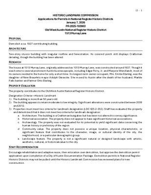
HISTORIC LANDMARK COMMISSION Applications for Permits in National Register Historic Districts January 7, 2026 PR-2025-103903 Old West Austin National Register Historic District 1513 Murray Lane 13 – 1 PROPOSAL Demolish a ca. 1927 contributing building. ARCHITECTURE Two-story stucco building with irregular roofline and fenestration. Its covered porch still displays Craftsman detailing, though the building has been altered. RESEARCH The house at 1513 Murray Lane, originally addressed as 1313 Murray Lane, was constructed around 1927. Though it was home to several prominent Austin businesspeople, including Edgar Perry, Jr. and Marjorie Wendlandt, most of its owners resided in the home for only a short time. Its longest-term owner-occupant, Mrs. Emilie Ebeling, was the daughter of New Braunfels mayor Adolph Giesecke. She moved to Austin after the death of her husband, Marble Falls banker and farmer Otto Ebeling. PROPERTY EVALUATION The property contributes to the Old West Austin National Register Historic District. Designation Criteria—Historic Landmark 1) The building is more than 50 years old. 2) The building appears to retain moderate to low integrity. Significant alterations were constructed between 2008 and 2012. 3) Properties must meet two criteria for landmark designation (LDC §25-2-352). Staff has evaluated the property and determined that it does not meet two criteria for landmark designation: a. Architecture. The building is a Craftsman bungalow but has been too altered to convey significance. b. Historical association. The property does not appear to have significant historical associations. c. Archaeology. The property was not evaluated for its potential to yield significant data concerning the human history or prehistory of the region. d. Community value. The property does not possess a unique location, physical characteristic, or significant feature that contributes to the character, image, or cultural identity of the city, the neighborhood, or a particular demographic group. e. Landscape feature. The property is not a significant natural or designed landscape with artistic, aesthetic, cultural, or historical value to the city. STAFF RECOMMENDATION Encourage rehabilitation and adaptive reuse, then relocation over demolition, but approve the demolition permit application upon completion of a City of Austin Documentation Package. Demolition permits in National Register Historic Districts may not be pulled until the Historic Landmark Commission has reviewed plans for new construction. LOCATION MAP 13 – 2 PROPERTY INFORMATION Photos 13 – 3 13 – 4 13 – 5 13 – 6 Occupancy History City Directory Research, September 2025 Demolition permit application, 2025 1959 1952 1944 1941 …
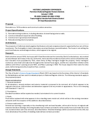
8 – 1 HISTORIC LANDMARK COMMISSION Permits in National Register Historic Districts January 7, 2026 PR-2025-143402; HR-2025-157653 Travis Heights-Fairview Park Historic District 811 East Riverside Drive Proposal Remodel a ca. 1918 residence and construct outdoor amenities. Project Specifications 1) Remodel existing residence, including alteration of street facing exterior walls. 2) Construct detached carport at side of building. 3) Construct an in-ground pool at backyard. 4) Relocate existing shed on property. Architecture The propoerty is Craftsman style bungalow that features a broad, wraparound porch supported by four sets of three wood posts. The front gable is clad in decorative wood and features several brackets. The house is set withing the porch and features several large windows, which appear to be original. Research Built sometime around 1918, the house at 811 East Riverside was first owned by Olin & Cordia Jackson, who worked as a bookkeeper and notary in the city. At the time, there were few residences built on this section of East Riverside, but it became more populated by 1922, when Arthur & Mary Yarrington bought the property. Arthur Yarrington worked as a merchant and salesman throughout the Central Texas region, and the two raised their children at the address until Arthur’s passing around 1950, and Mary’s passing in 1954. The house stayed in their name for a few years, before being owned by Josephine Pace, a widow. Design Standards The City of Austin’s Historic Design Standards (March 2021) are based on the Secretary of the Interior’s Standards for Rehabilitation and are used to evaluate projects in National Register districts. The following standards apply to the proposed project: Repair and alterations 1. General standards At all elevations, several windows and exterior material is proposed to be removed, all of which appears to be original to the house. Infill windows and alterations appear to be very modern in appearance. This is not in keeping with Standard 1.1 and 1.2. 2. Foundations Elevated foundation will be repaired as needed, but retained in its current location. 3. Roofs Roof will be replaced with what appears to be a standing seam metal roof, which will be in the existing orientation and pitch (with the exception of the additions described below). 4. Exterior walls and trim Several new openings, especially on the streetfacing north and east facades, will result in the loss of original wall material. Elevation drawings of existing facades have not been provided …
18 ANTECEDENTES EAST RIVERSIDE DR R 5 8'- 0 1/4 " ( F U L L C R Z ) 13" BURR OAK 204 7" BURR OAK 114 R A D ALMED RIVERSIDE DR RUTHERFORD PL AVONDALE RD E V A A A VIS T T L A ACADEMY DR EDGECLIFF TER Lady Bird Lake RIVERSIDE DR D V L S B T H EIG VIS H A R T 109 12" POST OAK LOCATION L A E S 10/09/2024 R 2 9'-0 1/4"(1/2 C R Z) " 0 - ' 5 2 218 236 GARDEN R14'-6"(1/4 CRZ) 58" LIVE OAK 51" LIVE OAK 1 0 8 ' - 8 1 / 4 " R12'-9"(1/4 CRZ) 60'-10 7/8" GARDEN EXISTING COVERED PORCH 463.69 SQ. FT. ROOF lvl. +18' 1/2" TERRACE lvl. +0.00 ADDITION STAIR CASE 34.86 SQ. FT. ROOF lvl. +20' 11 1/2" RIDGE ROOF EXISTING TWO STORY RESIDENCE 3BED/2.5BA 1,520.98 SQ. FT. A L T A V I S T A A V E 108 6" BURR OAK 107 9 1'- 2 1 / 8 " 106 8",8",6.5" CREPE MYRTLE R8'-0 1/4"(FULL CRZ) R4'(1/2 CRZ) R2'(1/4 CRZ) 8" PECAN R25'-6"(1/2 CRZ) 16" DEAD lvl. -1'-6" PERMEABLE FLOOR 152 POOL 184.76 SQ. FT. lvl. -5'-6" 5'-0" TERRACE PROPOSED DECK 785.82 SQ. FT. lvl. -1'-6" 176 lvl. -1'-6" lvl. +6'-10" RELOCATED EXISTING STORAGE 126.04 SQ. FT. ROOF lvl. -0'-6" ROOF lvl. +9'-6" PERMEABLE FLOOR EMPTY lvl. -0'-6" SETBACK PROPOSED CARPORT 505.53 SQ. FT. 15'-0" 1 0 ' - 0 " PROPERTY LINE 81'-3 7/8" R5'(1/4 CRZ) 196 R10'(1/2 CRZ) 11" HACKBERRY R20'(FULL CRZ) 20" LIVE OAK R2'-9"(1/4 CRZ) R5'-6"(1/2 C RZ) Z) R L C L U 1 3/4"(F 0'-1 1 R Z) R ULL C R50'-11 3/4"(F 0(cid:10)1(cid:10) 2(cid:10) 0(cid:10)1(cid:10) 3(cid:10) 4(cid:10) 7(cid:10) 8(cid:10) 15(cid:10) 20(cid:10) 35(cid:10) 30(cid:10) 65(cid:10) SURVEY 3(cid:18)32(cid:5)(cid:32)1(cid:10)(cid:16)0(cid:5) 2 SITE PLAN 3(cid:18)32(cid:5)(cid:32)1(cid:10)(cid:16)0(cid:5) 1 . C L L i , n g s e D e v i t a N n i t s u A f i i o n o s s m r e p n e t t i r w e h t t u o h t i w d e t i i b h o r p y l t c i r t s s i n o i t c u r t s n o c r e h o t y n a i g …
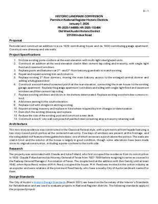
HISTORIC LANDMARK COMMISSION Permits in National Register Historic Districts January 7, 2026 PR-2025-144889; HR-2025-155496 Old West Austin Historic District 2310 Windsor Road 9 – 1 Proposal Remodel and construct an addition to a ca. 1929 contributing house and ca. 1930 contributing garage apartment. Construct new driveway and site walls. Project Specifications 1. Enclose existing porte-cochere at the east elevation with multi-light steel glazed units. 2. Construct an addition at the west elevation clad in fiber cement lap siding and masonry, with single-light fixed and casement windows. 3. Replace posts and balusters at 2nd- and 3rd-floor balcony guardrails to match existing. 4. Repair and repaint existing trim and columns. 5. Replace existing 3rd-floor dormers, moving the main balcony access to the enlarged central dormer and adding a fully glazed door. 6. Construct a wood-framed screened porch at the rear elevation, connecting the main house to the existing garage apartment. Replace the garage apartment’s windows and siding with single-light fixed and casement windows and fiber cement lap siding. 7. Replace existing windows and doors in-kind where deteriorated. Replace existing wood window screens in- kind. 8. Add a new awning to the south elevation. 9. Replace roof with shingles matching existing. 10. Repoint existing masonry and replace in-kind where required by trim changes or deterioration. 11. Demolish the existing driveway and replace. 12. Reduce the size of the existing pool and construct a new deck. 13. Construct a new 6’ site wall composed of painted steel screening atop a masonry retaining wall. Architecture This two-story residence was constructed in the Classical Revival style, with a symmetrical front façade featuring a two story curved porch portico at the centered main entry. Five bays of windows are present at this frontage, and the side gabled roof features three gabled windows, one of which accesses a porch above the portico. The walls are clad in brick and the exterior of the hosue is largely in good condition, though some alterations have been made since its original construction, including a porte-cochere to the north side. Research The property was associated with Claude and Julia Pollard, who first occupied the residence from its construction in 1929. Claude Pollard served as Attorney General of Texas from 1927-1929 before resigning to serve as counsel to the Railway General Managers’ Association of Texas. The couple lived at the address with their family until at least 1942, when Alyce Reed, widow of …
SHEET IS FORMATTED TO 24" X 36". SCALES ARE ONE HALF OF NOTED WHEN PRINTED TO 12" X 18". SHEET INDEX ADDED REVISED REMOVED SHEET A.000 A.101 A.102 A.103 A.104 A.201 A.202 A.203 A.204 A.205 A.206 A.207 A.208 A.301 A.302 A.303 A.304 A.305 A.306 A.307 TITLE TITLE DEMO SITE PLAN PROPOSED SITE PLAN TREE PROTECTION SITE PLAN IC CALCULATIONS DEMO FIRST FLOOR PLAN DEMO SECOND FLOOR PLAN DEMO THIRD FLOOR PLAN FIRST FLOOR PLAN SECOND FLOOR PLAN THIRD FLOOR PLAN GARAGE FLOOR PLAN & DEMO PLANS ROOF PLAN BUILDING ELEVATIONS BUILDING ELEVATIONS SECTION / ELEVATIONS HLC ELEVATIONS HLC ELEVATIONS HLC ELEVATIONS HLC ELEVATIONS ● ○ I T M R E P 5 2 / 7 0 / 1 1 ● ● ● ● ● ● ● ● ● ● ● ● ● ● ● ● ● ● ● ● BUILDING PERMIT #: GENERAL NOTES: ABBREVIATIONS: ABV ADA ADJ AFF ALUM ANOD APPROX ARND BATH BLW BLDG BRK BYND CBNT CH CIP CL CMU CONC CONT COVD CNTRTP DBL D FIR DN DRWR DTL DWG EA ELEC ELEV EQ EXIST EXT FD FG FL FO FT FXD GWB HB HT INSUL INT LVL MANF MARB MAX MEMB MIN MR MRGWB NG NIC NTS O/ OAE OC OSB PNL PT PTD QTY RCP REQ RM RVL SQFT SS STL STND SURF SUS STRUCT TB TBD T&G TOW TP TYP UON VIF W/ WD W / D WNDW WP WR WRB ABOVE AMERICANS WITH DISABILITIES ACT ADJACENT / ADJUSTABLE ABOVE FINISH FLOOR ALUMINUM ANODIZED APPROXIMATELY AROUND BATHROOM BELOW BUILDING BREAK OR BRAKE BEYOND SECTION CUT CABINET CEILING HEIGHT CAST IN PLACE CLEAR OR CENTERLINE CONCRETE MASONRY UNIT CONCRETE CONTINUOUS COVERED COUNTER TOP DOUBLE DOUGLAS FIR DOWN DRAWER DETAIL DRAWING EACH ELECTRIC / ELECTRICAL ELEVATION EQUAL EXISTING EXTERIOR FLOOR DRAIN FINISHED GRADE FLOOR FACE OF FEET FIXED GYPSUM WALL BOARD HOSE BIB - FROST FREE HEIGHT OR HAND TOWEL (BLOCKING) INSULATION INTERIOR LAMINATED VENEER LUMBER MANUFACTURER MARBLE MAXIMUM MEMBRANE MINIMUM MOISTURE RESISTANT MR GYPSUM WALL BOARD NATURAL GRADE NOT IN CONTRACT NOT TO SCALE OVER OR APPROVED EQUAL ON CENTER ORIENTED STRAND BOARD PANEL PRESSURE TREATED PAINTED QUANTITY REFLECTED CEILING PLAN REQUIRED ROOM REVEAL SQUARE FEET STAINLESS STEEL STEEL STAINED / CLEAR FINISHED SURFACE SUSPENDED STRUCTURAL ENGINEER TOWEL BAR (ADD BLOCKING) TO BE DETERMINED TONGUE & GROOVE TOP OF WALL TOILET PAPER HOLDER (BLOCKING) TYPICAL UNLESS OTHERWISE NOTED VERIFY IN FIELD WITH WOOD WASHER …
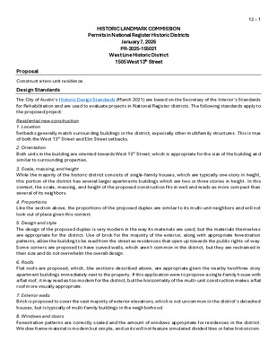
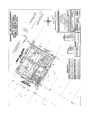
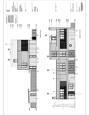
HISTORIC LANDMARK COMMISSION Permits in National Register Historic Districts January 7, 2026 PR-2025-155021 West Line Historic District 1505 West 13th Street 12 – 1 Proposal Construct a two-unit residence. Design Standards The City of Austin’s Historic Design Standards (March 2021) are based on the Secretary of the Interior’s Standards for Rehabilitation and are used to evaluate projects in National Register districts. The following standards apply to the proposed project: Residential new construction 1. Location Setbacks generally match surrounding buildings in the district, expecially other multifamily structures. This is true of both the West 13th Street and Elm Street setbacks. 2. Orientation Both units in the building are oriented towards West 13th Street, which is appropriate for the size of the building and similar to surrounding properties. 3. Scale, massing, and height While the majority of the historic district consists of single-family houses, which are typically one-story in height, this portion of the district has several larger apartments buildings which are two or three stories in height. In this context, the scale, massing, and height of the proposed construction fits in well and reads as more compact than several of its neighbors. 4. Proportions Like the section above, the proportions of the proposed duplex are similar to its multi-unit neighbors and will not look out of place given this context. 5. Design and style The design of the proposed duplex is very modern in the way its materials are used, but the materials themselves are appropriate for the district. Use of brick for the majority of the exterior, along with appropriate fenestration patterns, allow the building to be read from the street as residences that open up towards the public rights-of-way. Some corners are proposed to have curved walls, which aren’t common in the district, but they are restrained in their size and do not overwhelm the overall design. 6. Roofs Flat roofs are proposed, which, like sections described above, are appropriate given the nearby two/three story apartment buildings immediately next to the property. If this application were to propose a single-family house with a flat roof, it may read as too modern for the district, but the horizontality of the multi-unit construction makes a flat roof more visually appropriate. 7. Exterior walls Brick is proposed to cover the vast majority of exterior elevations, which is not uncommon in the district’s detached houses, but is typically of multi-family buildings in the …
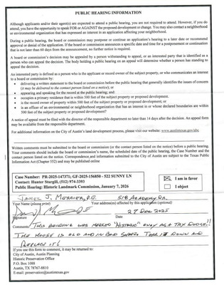
HISTORIC LANDMARK COMMISSION Permits in National Register Historic Districts January 7, 2026 PR-2025-147371 Travis Heights-Fairview Park Historic District 522 Sunny Lane 13 – 1 Proposal Demolish a ca. 1930 contributing structure. Architecture This house is a single-story residence with Tudor Revival details. The entire house is clad in buff brick and features a steeply pitched gable roof. The windows appear to be original, though some have been removed, and rafter tails are present at the sides of the building. Though it has some damage and loss of material, the exterior walls appear to be in decent condition. Research Upon construction, the house was first owned by Robert & Birdie Lundell, an auto mechanic in the city. It’s unclear exactly when, but during World War II it changed ownership to Jack & Ellen Ferrell, the former of whom served in the US Army. By 1949, the property was purchased by Forest & Dolores Cruse. Forest Cruse had a business selling imported cutlery and was an amateur chef who competed across the country. Together they raised a family and at least one son went into the family cutlery business. Property Evaluation The property contributes to the Travis Heights-Fairview Park National Register district. Designation Criteria—Historic Landmark 1) The building is more than 50 years old. 2) The building appears to retain moderate integrity. 3) Properties must meet two criteria for landmark designation (LDC §25-2-352). Staff has evaluated the property and determined that it does not meet two criteria for landmark designation: a. Architecture. The building is a decent example of residential architecture with Tudor Revival elements. b. Historical association. The property does not appear to have significant historical associations. c. Archaeology. The property was not evaluated for its potential to yield significant data concerning the human history or prehistory of the region. d. Community value. The property does not possess a unique location, physical characteristic, or significant feature that contributes to the character, image, or cultural identity of the city, the neighborhood, or a particular demographic group. e. Landscape feature. The property is not a significant natural or designed landscape with artistic, aesthetic, cultural, or historical value to the city. Staff Recommendation Encourage rehabilitation and adaptive reuse, relocation, or deconstruction and salvage over demolition, but approve the demolition permit application upon completion of a City of Austin Documentation Package. The Historic Landmark Commission must review plans for new construction in National Register districts …
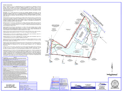
PROPERTY DESCRIPTION: BEING A PORTION OF LOT 70-A, RESUBDIVISION OF LOT 70, WOODLAWN, AN ADDITION TO TRAVIS COUNTY, TEXAS, ACCORDING TO THE PLAT THEREOF RECORDED IN VOLUME 8, PAGE 146, PLAT RECORDS, TRAVIS COUNTY, TEXAS, BEING THE REMAINDER OF THAT CERTAIN TRACT OF LAND CONVEYED IN DEED TO FIVE TWO TWO, LLC, AS RECORDED IN INSTRUMENT NO. 2022196840, OFFICIAL PUBLIC RECORDS, TRAVIS COUNTY, TEXAS, AND BEING MORE PARTICULARLY DESCRIBED BY METES AND BOUNDS AS FOLLOWS: BEGINNING AT A 1/2-INCH IRON ROD SET WITH CAP STAMPED “PREMIER SURVEYING” AT THE SOUTHWEST CORNER OF SAID LOT 70-A AND THE NORTHWEST CORNER OF LOT 10, WOODLAWN, AN ADDITION TO TRAVIS COUNTY, TEXAS, ACCORDING TO THE PLAT THEREOF RECORDED IN VOLUME 3, PAGE 130B, SAID PLAT RECORDS, SAID IRON ROD BEING ON THE EAST LINE OF SUNNY LANE (50 FOOT RIGHT-OF-WAY); THENCE NORTH 05° 08' 00” EAST, A DISTANCE OF 56.50 FEET ALONG SAID EAST LINE TO A SET MAG NAIL AT THE MOST SOUTHERLY NORTHWEST CORNER OF SAID LOT 70-A, THE WEST CORNER OF LOT 70-B, AFORESAID RESUBDIVISION, AND THE SOUTH CORNER OF THAT CERTAIN TRACT OF LAND DESCRIBED IN DEED TO MEHRAD YASREBI AND MARYAM NEDA YASREBI, AS RECORDED IN INSTRUMENT NO. 2019094928, AFORESAID OFFICIAL PUBLIC RECORDS; THENCE SOUTH 58° 34' 00” EAST, A DISTANCE OF 60.75 FEET ALONG THE COMMON LINE OF SAID LOTS 70-A AND 70-B TO A 1/2-INCH IRON ROD SET WITH CAP STAMPED “PREMIER SURVEYING” FROM WHICH A 1/2-INCH IRON ROD FOUND BEARS SOUTH 73° 12' 38” WEST - 1.98 FEET, SAID IRON ROD SET BEING THE SOUTH CORNER OF SAID LOT 70-B; THENCE NORTH 30° 58' 00” EAST, A DISTANCE OF 144.14 FEET ALONG SAID COMMON LINE TO A POINT FROM WHICH A FENCE CORNER BEARS NORTH 72° 57' EAST - 2.3 FEET, SAID POINT BEING ON THE SOUTHWEST LINE OF RIVERSIDE DRIVE (VARIABLE WIDTH RIGHT-OF-WAY), BEING THE BEGINNING OF A NON-TANGENT CURVE TO THE RIGHT HAVING A RADIUS OF 107.75 FEET; THENCE ALONG SAID SOUTHWEST LINE AND SAID CURVE AN ARC DISTANCE OF 60.74 FEET, HAVING A CHORD BEARING AND DISTANCE OF SOUTH 21° 12' 49” EAST - 59.94 FEET TO A SET MAG NAIL; THENCE SOUTH 05° 04' 00” EAST, A DISTANCE OF 11.00 FEET ALONG SAID SOUTHWEST LINE TO A 1/2-INCH IRON ROD SET WITH CAP STAMPED “PREMIER SURVEYING”; THENCE SOUTH 29° 30' 38” EAST, A DISTANCE OF 12.08 FEET ALONG SAID SOUTHWEST LINE …
HISTORIC LANDMARK COMMISSION Permits in National Register Historic Districts January 7, 2026 HR-2025-157977 West Line Historic District 1105 Maufrais Street 14 – 1 Proposal Construct a new house in a historic district. Research The house at 1105 Maufrais St. was built in 1937 for G. R. Ogletree, a lumber company who constructed several similar houses on Maufrais Street. Its first occupant was William A. Chanslor, an employee of the State Comptroller’s Department. It was soon sold by Chanslor and purchased by Jack P. and Lovie McKinney. Jack P. McKinney worked as a salesman. Most of the building’s owners throughout the period of significance sold the property after only a short occupancy. Design Standards The City of Austin’s Historic Design Standards (March 2021) are based on the Secretary of the Interior’s Standards for Rehabilitation and are used to evaluate projects in National Register districts. The following standards apply to the proposed project: Residential new construction 1. Location Proposed setback is in keeping with outher houses on the block and district. 2. Orientation The proposed orientation faces the street, like other contributing properties in the district. 3. Scale, massing, and height Design calls for a single-story house, with massing and height similar to its neighbors. 4. Proportions The proportions are very aligned with historic houses in the district generally and the block specifically. 5. Design and style While stylistically similar to contributing properties, the new construction reads as being outside the period of significance. Some elements, such as the stone skirt and paired wood posts, can read as contemporary but compatible. Brackets are present at the roofline but are simple in design to further indicate this compatibility with surrounding historic forms. 6. Roofs Roof form is simple and appropriate for the district. Materials proposed, such as composition shingle, do not create a false sense of history. 7. Exterior walls Proposed siding is mostly horizontal wood lap with a stone skirt at the front façade. While masonry skirting is not commonly found in the district, it fits the overall design and proportions of the house, though it is advised that the design avoid creating cabin-like appearance with the shape and proportion of its stones. 8. Windows and doors Window sizes and appearances are appropriate for the district. Especially at the front elevation, the windows are proposed to be hung units with appropriate depth and will not utilize false or simulated muntins or mullions. …
HISTORIC LANDMARK COMMISSION Applications for Permits in National Register Historic Districts January 7, 2026 PR-2025-157729; GF-2025-158085 Congress Avenue National Register Historic District 422 Congress Avenue 13 – 1 Proposal Demolish a ca. 1940 noncontributing building deemed eligible for contributing status in the 2025 Downtown Austin historic resources survey. Architecture Two-part commercial block. The 2025 survey notes that the building has been modified to include Mid-century Modern stylistic influences. Originally a masonry structure with decorative belt courses at the water table and second floor, with steel casement windows, it was drastically remodeled between 1967 and 1978 to add stucco and a projecting second floor. Per permits, two doors were added and the storefront relocated in 2004, and the rooftop structure was added in 2007 and expanded in 2015. Research The building at 422 Congress Avenue, originally addressed as 420-422 Congress Avenue, was constructed in 1940. It was the headquarters for the Texas Public Service Company’s natural gas division. By 1951, it was renamed as the company changed hands and became the headquarters for the Southern Union Gas Company. Property Evaluation The property does not currently contribute to the Congress Avenue National Register district, but the 2025 Downtown Austin historic resource survey lists it as a medium priority, recommends that the property be considered contributing in a future update to the 1978 National Register nomination, and identifies it as contributing to a potential local historic district. A 2015 staff report by former City of Austin Historic Preservation Officer Steve Sadowsky notes that the building does not have historic significance, though district eligibility was not considered at that time. Designation Criteria—Historic Landmark 1) The building is more than 50 years old. 2) The building appears to retain moderate to low integrity. Exterior walls were altered in 1967 and 1968 to include a projecting stucco second floor. A rooftop structure was added in 2007 and expanded in 2015. 3) Properties must meet two criteria for landmark designation (LDC §25-2-352). Staff has evaluated the property and determined that it does not meet two criteria for landmark designation: a. Architecture. The building is a two-part commercial block with Mid-century Modern stylistic influences. It does not retain sufficient integrity to convey architectural significance. b. Historical association. The property is associated with several natural gas businesses. c. Archaeology. The property was not evaluated for its potential to yield significant data concerning the human history or prehistory of the …
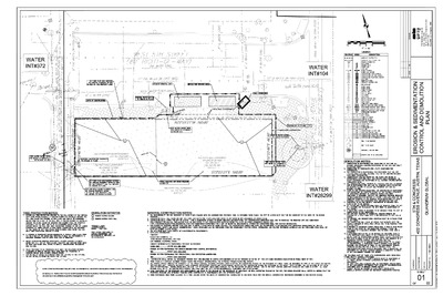
HISTORIC LANDMARK COMMISSION Applications for Permits in National Register Historic Districts January 7, 2026 PR-2025-157738; GF-2025-158191 Congress Avenue National Register Historic District 101-105 W. 5th Street 14 – 1 Proposal Demolish a ca. 1914 noncontributing building deemed eligible for contributing status in the 2025 Downtown Austin historic resources survey. Architecture The existing building is a one-part commercial block comprising three tenant spaces, first addressed only as 105 W. 5th Street and then expanded to include a service station and a double-tenant space at 101-103 W. 5th Street by 1916. It exists today as a small portion of the alley-facing rear entry adjacent to 416 Congress Ave. Selective demolition may expose original masonry behind the stucco slipcover, likely applied as early as 1933 and continually replenished since. Research The property spanning 101 to 105 W 5th St. was used early in the development of downtown as storage space for the early frame buildings at 420 and 422 Congress Avenue. By 1885, an outbuilding and a connected shed were present at the rear of the lot. In 1914 and 1915, John Dahlich, the owner of 422 Congress, constructed three new masonry buildings at the rear of his property. The westernmost building, used as a tire shop and mechanic, featured a plate glass window and bay door. The complex included a vulcanizing plant and underground gasoline tank. The property continued to serve automobile-related businesses until the 1930s, When it was occupied by a dry cleaner, a glass company, and a grinding and sharpening shop. During the ‘40s they were home to a sign shop, a sporting goods store, a children’s clothing shop, and a beauty salon. Several of these uses continued into the mid-20th century. Property Evaluation The property does not currently contribute to the Congress Avenue National Register district, but the 2025 Downtown Austin historic resource survey lists it as a medium priority, recommends that the property be considered contributing in a future update to the 1978 National Register nomination, and identifies it as contributing to a potential local historic district. A 2015 staff report by former City of Austin Historic Preservation Officer Steve Sadowsky notes that the building does not have historic significance, though district eligibility was not considered at that time. Designation Criteria—Historic Landmark 1) The building is more than 50 years old. 2) The building appears to retain moderate to low integrity. The 2025 Downtown Austin survey notes that …
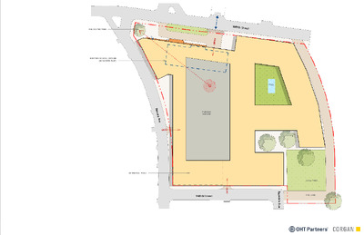
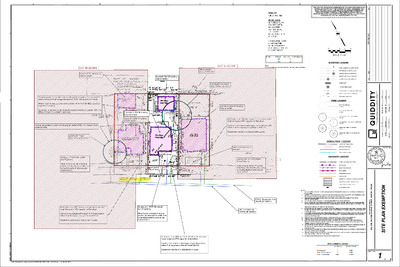
HISTORIC LANDMARK COMMISSION Applications for Demolition and Relocation Permits January 7, 2026 DA-2025-142965; GF-2025-146214 Rosedale School 2117 W. 49th Street 15 – 1 Proposal Deconstruct and reconstruct a portion of the historic-age façade of a ca. 1939 building for incorporation into a new apartment building. The remainder of the building will be demolished and five additional stories will be constructed atop the first-floor façade reconstruction. Architecture The Rosedale school is a one-story brick school building with Modern stylistic influences. The original portion of the building is a simple flat-roofed brick structure with decorative string courses and expansive multi-light casement windows. Additions, constructed between 1946 and 1949 by two firms (Kuehne, Giesecke, and Brooks and Page, Southerland, and Page), replaced the original entrance with glass block windows and shifted the new entrance eastwards. The new shed- and flat-roofed wings with multi-light casements, glass block ribbon windows, and brick veneer comprised 10 additional classrooms plus a gym and cafeteria/auditorium.1 A 1949 Austin Statesman article advertising the opening of the new addition notes that the “highly modern Rosedale school” is “considered a model of functional design” following Dr. Darrell B. Harmon’s principles for classroom design.2 The extensive use of glass block and retention of maximum natural lighting in four “experimental” classrooms was dictated by the design hypothesis developed by Harmon, Director of Educational Services in the State Health Department: The south side of Rosedale School will have special windows. …The blocks will promote even distribution of light, and the vision strip will allow the children to see out. The remaining four rooms will be equipped with auxiliary diffusers based on an original design by Dr. Harmon which are placed inside the windows. These diffusers obtain maximum benefit from direct sunlight without permitting excessive brightness and threw light upward and across the ceiling from which it is reflected downward on the child’s work. This will be the only school coordinating natural and artificial light…3 Harmon’s work on the “Rosedale model” of classroom illumination was influential to educational design on a national scale during the mid-20th century. In a 2008 article for the Journal of the Society of Architectural Historians, Amy Ogata describes the impact of the Rosedale model on American school design: The planning, forms, and materials of postwar schools reflected ongoing research into airflow, lighting, and reflectivity…Darell Boyd Harmon, an educator and director of school services at the Texas State Department of Health, …
RELOCATED TREE ' 3 EXISTING SCHOOL OUTLINE (IN DASHED BLUE) EXISTING CURB CUT PROPOSED ENTRY DRIVE (AS PER ATP REQUIREMENTS) W49th Street Y R T N E POOL R a m s e y A v e ENTRY PARKING GARAGE DETENTION POND Y R T N E W48th Street 0.46 ac PARD FIRE LANE R o s e d a l e A v e 2117 WEST 49th ST - Austin, TX
HISTORIC LANDMARK COMMISSION Demolition and Relocation Permits January 7, 2026 DA-2025-141132 906 West 22nd Street 16 – 1 Proposal Demolish a ca. 1927 building. Architecture The property at 906 West 22nd Street in the West Campus neighborhood is a two-story intact Folk Victorian house with an L-shaped plan. It features a front porch at the right half of the front façade which is recessed under the second floor and supported by three wood posts. The house is built on piers and sits a few feet above grade. At the left, one leg of the L projects toward the street and is covered with a steep pitched gable, which creates enough height to house living space within. There appears to have been alterations made to the original roof above the porch to create more living space, which was permitted in 1948. It is unknown how much alteration of the original roof took place at that time. Research This house was originally owned by Jesse and Emily Hornsby, who were farmers either at this address or further out from Austin, making this possibly a second property closer to the city. Jesse Hornsby passed away in 1933, with the funeral services taking place at the property. For a short time after, the house was vacant, but was purchased around 1941 by David and Irene Crenshaw. At time of purchase, David Crenshaw was employed as a clerk, but in the next few years, through the 1950s and possibly further, made their living renting out rooms to University of Texas students. The address is connected with numerous names in periodicals form the time, typically students and other short-term renters It was during this time that the conversion of the second floor into additional living quarters occurred. Property Evaluation The 2020 North Central Austin historic resource survey lists the property as individually eligible for the National Register of Historic Places as well as eligible for a Austin City landmark. Designation Criteria—Historic Landmark 1) The building is more than 50 years old. 2) The building appears to retain moderate-to-high integrity. 3) Properties must meet two criteria for landmark designation (LDC §25-2-352). Staff has evaluated the property and determined that it may meet two criteria for landmark designation: a. Architecture. The building is a good example of Folk Victorian architecture, even with 1948 alterations. b. Historical association. The property does not appear to have significant historical associations. c. …
THE LOCATION OF EXISTING UNDERGROUND UTILITIES ARE SHOWN IN AN APPROXIMATE WAY ONLY. THE CONTRACTOR SHALL DETERMINE THE EXACT LOCATION OF ALL EXISTING UTILITIES BEFORE COMMENCING WORK. HE AGREES TO BE FULLY RESPONSIBLE FOR ANY AND ALL DAMAGES WHICH MAY OCCUR BY HIS FAILURE TO EXACTLY LOCATE AND PRESERVE ANY AND ALL UNDERGROUND UTILITIES. . p p A I S N O S V E R I 20 0 10 20 SCALE: 1" = 20' EXISTING LEGEND W W WW WW FIRE HYDRANT W/ GATE VALVE WATERLINE W/ GATE VALVE WASTEWATER W/ MANHOLE WASTEWATER W/ CLEANOUT STORM SEWER W/ MANHOLE CURB INLET 4-SIDED AREA INLET t e a D . o N OHE Z OVERHEAD ELECTRIC W/POWER POLE 3504 700 PROPERTY STREET ADDRESS GROUND CONTOUR TREE LEGEND TREE TO REMAIN (8"-18") TREE TO BE REMOVED (8"-18") PROTECTED TREE TO REMAIN (19"-23") PROTECTED TREE TO BE REMOVED (19"-23") HERITAGE TREE TO REMAIN (24"+) HERITAGE TREE TO BE REMOVED (24"+) DEMOLITION LEGEND LIMITS OF DEMOLITION DEMOLITION AREA DEMOLITION LINE TREE PROTECTION EROSION LEGEND LIMITS OF CONSTRUCTION SILT FENCE INLET PROTECTION ROCK BERM TREE PROTECTION MULCH LOG STABILIZED CONSTRUCTION ENTRANCE CONSTRUCTION STAGING AREA TEMPORARY SPOILS AREA FLOW DIRECTION NOTES: 1. AE CUSTOMER SERVICE TO BE CONTACTED FOR DISCONNECTION OF ELECTRICAL SERVICES AT 512-494-9400 2. CAPPING AND PLUGGING OF WATER AND WASTEWATER SERVICES AS PER THE PLUMBING CODE ON PRIVATE PROPERTY WITHIN FIVE FEET (5') OF PROPERTY LINE. 3. EROSION AND SEDIMENTATION CONTROLS ARE TO BE PLACED OUTSIDE OF THE TREE PROTECTION FENCING. 4. SEE DETAIL 520S-2 ON SHEET 2 FOR ABANDONMENT OF W/WW SERVICES 5. TREE PROTECTION FENCING IS REQUIRED FOR ALL TREES WITHIN THE LIMITS OF DESTRUCTION ON SITE BEFORE DEMOLITION OCCURS. WHERE FENCING CANNOT BE PLACED TO PROTECT THE EXTENT OF THE CRZ WITH NATURAL GROUND COVER, PROVIDE AN 8” LAYER OF ORGANIC HARDWOOD MULCH OUTSIDE OF THE FENCING. 7. 6. STRAPPING 2X4 OR THICKER LUMBER (TO MATCH HEIGHT OF BUILDING) SECURELY AROUND TREE TRUNK, BUTTRESS ROOTS, AND ROOT FLARE, IS REQUIRED IF FENCING CANNOT GO AROUND THE ENTIRE HALF CRZ. IF PRUNING IS NECESSARY DURING DEMOLITION, IT SHOULD TAKE PLACE PRIOR TO THE START OF THE DEMOLITION PROCESS. IT MUST BE PERFORMED BY A QUALIFIED ARBORIST AND NO MORE THAN 25% IS PERMITTED. PROVIDE TREE PROTECTION FOR ALL TREES 8 INCHES OR GREATER IN DIAMETER. INSTALL TREE PROTECTION FENCING PRIOR TO ANY DEMOLITION ACTIVITIES. 8. 9. 10. CRITICAL ROOT ZONE …
HISTORIC LANDMARK COMMISSION Applications for Demolition and Relocation Permits January 7, 2026 PR-2025-138065; GF-2025-144692 907 East 13th Street 15 – 1 Proposal Demolish a house constructed between circa 1873 and 1884. Architecture One-story center passage National Folk Style building with horizontal wood siding, a partial width front porch supported by turned posts, a side-gabled roof clad with standing seam metal, and double hung wood windows. While the front door has been replaced, the trim and transom above the window remain. Research The house at 907 E 13th St, originally addressed as 907 E Peach St, was built between 1873 in 1885 by Julius H. Nitschke. Nitschke and his family immigrated from Saxony, Germany in 1855. He and his four brothers owned and operated Nitschke Brothers Cabinetmakers on Congress Ave. Nitschke married Louisa Phillips in 1871. He worked as a carpenter, cabinet maker, and carpet layer until his death in 1910. His son, J.H. Nitschke Jr., also worked as a carpenter and dabbled in car repair and railroad work before becoming a career fireman. He sold 907 E 13th St. to the Goins family between 1912 and 1920. Anna Liza Goins, formerly of Manor, lived in the home until her death in 1956. She worked as a cook and as a laundress while also renting out rooms. Her children and their spouses lived with her intermittently throughout the early 20th century. After her death, her daughter Roxy Tucker lived there until at least the 1960s. The home’s occupancy is emblematic of how the demographics of this East Austin neighborhood changed. European immigrant families, numerous at the turn of the century, gradually migrated elsewhere while African American families were forced to migrate eastwards during the era of segregation. However, all of the building’s occupants were working class people who innovated to support their families and to build communities in the face of inequality and segregation. Property Evaluation The 2016 East Austin survey lists the property as eligible for local landmark listing, individual listing on the National Register of Historic Places, contributing to a potential local historic district, and contributing to a potential National Register district. Designation Criteria—Historic Landmark 1) The building is more than 50 years old. 2) The building appears to retain moderate integrity. The original porch was modified during the period of significance; the provenance of the existing turned posts is unclear. The porch was rehabilitated and incompatible asbestos siding …
HISTORIC LANDMARK COMMISSION Demolition and Relocation Permits January 7, 2026 PR-2025-149298 1205 East 13th Street 18 – 1 Proposal Demolish a ca. 1900 house. Architecture House is a single-story residence clad in vinyl siding. The roof is a side-gable assembly set at a moderate pitch. If there were any decorative elements at the original house, they are no longer present or covered by previous repairs or cladding. At the front, there is a porhc that extends across the middle of the façade. There is a rear addition that was permitted in 1969. The building retains its original form, but it is unknown how much material has been lost since construction. Research Few details could be found about the property and its residents apart from city directory listings. The first occupants were listed as renters and worked as laborers, laudresses, a porter, and a horseshoer. A couple, Wiley & Daphne Thompson, later owned the house for several decades. After Wiley Thompson’s passing around 1940, Daphne continued living there until the early 1950s, after which it was purhcased by Rev. James & Louis McDonald. Property Evaluation The 2016 East Austin historic resource survey lists the property as contributing to a potential local or National Register historic district. Designation Criteria—Historic Landmark 1) The building is more than 50 years old. 2) The building appears to retain low integrity. 3) Properties must meet two criteria for landmark designation (LDC §25-2-352). Staff has evaluated the property and determined that it does not meet two criteria for landmark designation: a. Architecture. The building does not appear to convey architectural significance due to significant alterations. b. Historical association. The property does not appear to have significant historical associations. c. Archaeology. The property was not evaluated for its potential to yield significant data concerning the human history or prehistory of the region. d. Community value. The property does not possess a unique location, physical characteristic, or significant feature that contributes to the character, image, or cultural identity of the city, the neighborhood, or a particular demographic group. e. Landscape feature. The property is not a significant natural or designed landscape with artistic, aesthetic, cultural, or historical value to the city. Staff Recommendation Encourage rehabilitation and adaptive reuse, relocation, or deconstruction and salvage over demolition, but approve the demolition permit application upon completion of a City of Austin Documentation Package. Location Map 18 – 2 Property Information Photos 18 …
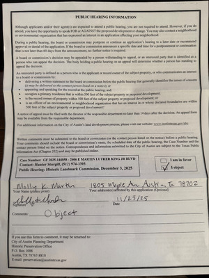
Sturgill, Hunter From: Sent: To: Cc: Subject: patricia calhoun Monday, December 1, 2025 3:06 PM Historic Preservation Office patricia calhoun; Brenda Malik; Misael Ramos; Marilyn Poole 2406 E MLK, Jr. Blvd Demolition Protest Importance: High You don't often get email from Learn why this is important External Email - Exercise Caution Good afternoon, Hunter, Thank you for returning my call today regarding the Certificate of Appropriateness for 2406 E. Martin Luther King, Jr. Blvd.. I am a resident of the Rogers-Washington-Holy Cross Historic District and I am in favor of a Postponement of this ruling pending plans or some type of document showing the use of this property. This property is adjacent to an original and well-known homeowner of this Historic District; I would strongly object to approval for demolition without site plans or other documentation showing that the structure is not suitable for rehab. Thank you, Patricia Calhoun, ASID, IIDA, RID Patricia Calhoun THE PERFECT ADDITION 972-814-6543 (Cell) CAUTION: This is an EXTERNAL email. Please use caution when clicking links or opening attachments. If you believe this to be a malicious or phishing email, please report it using the "Report Message" button in Outlook. For any additional questions or concerns, contact CSIRT at "cybersecurity@austintexas.gov". 1 Sturgill, Hunter From: Sent: To: Subject: Attachments: 1(713)6282228 <ctmavayaalerts@austintexas.gov> Tuesday, December 2, 2025 8:19 AM Historic Preservation Office [Transcribed] Voice Message From: 1 (713) 6282228 VoiceMsg[ID=1414728 G=40 F=228 A=588B9018-E3E0-4915-B196-27EE696E9546 C=1 CID= 1(713)6282228].wav Hello, my name is Marilyn Webb. I'm a neighbor of case number 20. G F 202-514-4858. The 2406 East Mar(cid:415)n Luther King junior Boulevard. I object to this applica(cid:415)on. The builder or whoever owns the property has has never discussed the cer(cid:415)ficate of appropriateness of a demoli(cid:415)on at this contribu(cid:415)ng property. I would like to see any alterna(cid:415)ves to pull demoli(cid:415)on. As it is a contribu(cid:415)ng property. Please give me a call, I'm going to make an a(cid:425)empt to file this objec(cid:415)on. Thank you. Yes. 1 Sturgill, Hunter From: Sent: To: Cc: Subject: Dear Mr. Sturgill, Ora Houston Tuesday, December 2, 2025 9:49 AM Historic Preservation Office 2406 E. Martin Luther King, Jr., Blvd. - Case # - PR-2025-144142; GF 2025-144858 External Email - Exercise Caution I am Ms. Ora Houston and I own property at 1902 Maple Avenue, 78722, Lot 8 Washington Subdivision. Am requesting that the Historic Landmark Commission grant a postponement regarding the Certificate of Appropriateness for the above …
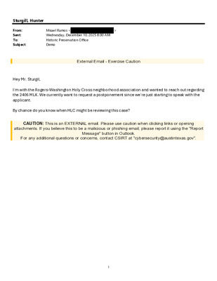
Sturgill, Hunter From: Sent: To: Subject: Misael Ramos < Wednesday, December 10, 2025 8:00 AM Historic Preservation Office Demo > External Email - Exercise Caution Hey Mr. Sturgil, I’m with the Rogers-Washington Holy Cross neighborhood association and wanted to reach out regarding the 2406 MLK. We currently want to request a postponement since we’re just starting to speak with the applicant. By chance do you know when HLC might be reviewing this case? CAUTION: This is an EXTERNAL email. Please use caution when clicking links or opening attachments. If you believe this to be a malicious or phishing email, please report it using the "Report Message" button in Outlook. For any additional questions or concerns, contact CSIRT at "cybersecurity@austintexas.gov". 1
Sturgill, Hunter From: Sent: To: Subject: Leslie Currens Monday, December 1, 2025 9:27 PM Historic Preservation Office Postpone the Demolition Permit Decision for Old Rosedale School You don't often get email from Learn why this is important External Email - Exercise Caution Dear Chairman Heimsath and commission members, As a neighbor near the Rosedale School, I request that you postpone a decision on the demolition of this property, as requested in case number: DA 25-142965. A legal fight over deed restrictions on the property is being waged in court, and it’s premature to consider a permit to demolish the building until the court case is resolved. The building itself may have useful life left on it. Until the future of the property is decided, it would be best not to demolish the building at this time. Sincerely, Leslie Currens 5615 Bull Creek Rd, Austin, TX 78756 CAUTION: This is an EXTERNAL email. Please use caution when clicking links or opening attachments. If you believe this to be a malicious or phishing email, please report it using the "Report Message" button in Outlook. For any additional questions or concerns, contact CSIRT at "cybersecurity@austintexas.gov". 1 Sturgill, Hunter From: Sent: To: Subject: Joshua Villarreal Monday, December 1, 2025 9:27 PM Historic Preservation Office Old Rosedale School You don't often get email from Learn why this is important External Email - Exercise Caution City of Austin Historic Landmark Commission, My name is Joshua Villarreal, I am a resident and owner of 4700 Rosedale Avenue, literally feet from the old Rosedale School. I am writing to express my concern as an Austin and Rosedale resident on the hearing tomorrow to decide the historical value and potential demolition of the school. It seems to be premature to hold this hearing while there is a court ruling in the balance on the site's existing deed restriction limiting a single residence per parcel, and the hearing should be postponed until there is clarity on what could be built on the site. There is also an active lawsuit from Austin Independent School District suing the Rosedale H homeowners, which includes myself and my wife. Pretty shocking to be sued by my own school district and feels like a breach of the social contract between citizens and their own government who is supposed to be for them, not against them. Thanks, -- Joshua Villarreal (210) 328-9679 CAUTION: This is an …
January 5, 2026 RE: Bethany Cemetery Historic Landmark Designation Dear Chair Heimsath, Vice Chair Evans, and Members of the Historic Landmark Commission Preservation Austin exists to empower Austinites to shape a more inclusive, resilient, and meaningful community culture through preservation. We write today in support of historic landmark designation for Bethany Cemetery for its community value, landscape features, and historical associations. Bethany Cemetery is one of Austin’s most significant sites of Black heritage, and we are honored to partner with the Bethany Cemetery Association and its leader, Sue Spears-Martin, in preparing this nomination. Established in 1893, Bethany Cemetery is the oldest known Black cemetery in Austin, providing burials to African Americans in Austin at a time when there were few options to do so. The cemetery encompasses hundreds of known burials, dating from 1879, before the official founding of the cemetery, to 1985. The people laid to rest at Bethany speak to the plurality of the African American experience in Austin, including stories of enslavement and emancipation, Buffalo Soldiers, State of Texas employees, religious leaders, domestic workers, entrepreneurs, and athletes. During an era when Black life was chronically under-documented in the official record, Bethany Cemetery provides a critical genealogical record for hundreds of lives. Bethany Cemetery exemplifies Black communal effort and perseverance in the absence of public support. With no municipal cemetery available to African Americans at the time, five Black businessmen established the Bethany Cemetery Company in 1893, purchasing the land and providing burials to Black Austinites. By the 1930s, Eva Taylor Ross led the effort to care for the cemetery, working to bring attention and remembrance to Bethany Cemetery until her passing in 1992. In the mid-1990s, the mantle was assumed by Sue Spears-Martin, current president of the Bethany Cemetery Association, whose leadership has mobilized community support, preserved Bethany’s stories, and sustained restoration efforts amid nearby development pressures. Bethany Cemetery provides a critical link to Austin’s Black past that must be preserved for generations to come. We are proud to support the designation of Bethany Cemetery as a City of Austin Landmark. Thank you for your consideration and your service to the City of Austin. Sincerely, Miriam Conner, President