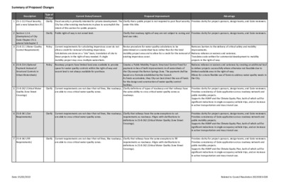
Summary of Proposed Changes Type of Change Clarify (Exemptions) of City Code Chapter 25-2, amend Subchapter E 3 25-8-211 (Water Quality Control Requirement) 4 25-8-214 (Optional Payment Instead of Structural Controls in Urban Watersheds) Description Current Status/Concern Proposed Improvement Advantage 1 25-1-112 Fiscal Security, add a new Subsection (F) Fiscal security is primarily intented for private development. The City has other existing mechanisms in place to accomplish the intent of this section for public projects. Clarify that a public project is not required to post fiscal security under this title. Provides clarity for project sponsors, design teams, and Code reviewers. 2 Section 1.2.4. Clarify Public right-of-way is not zoned land. Provides clarity for project sponsors, design teams, and Code reviewers. Clarify that roadway rights-of-way are not subject to zoning and land use rules. Policy Current requirements for calculating impervious cover do not allow a credit for removal of existing impervious. Calculations are done on a "site" basis, translation of site to linear projects in the right-of-way needed. A single mobility project may cross multiple watersheds. Policy Roadway projects have limited land area available to provide space for water quality controls within the right-of-way and vacant land is not always available for purchase. Revise procedure for water quality calculations to be determined on a watershed basis rather than for the total mobility project area and to allow for a credit for the removal of existing impervious cover. Removes barriers to the delivery of critical safety and mobility improvements. Reduces reliance on waivers and variances. Translates code written for commercial development to mobility projects in the right-of-way. 5 25-8-262 (Critical Water Quality Zone Street Crossings) Clarify Current requirements are not clear that rail lines, like roadways, are able to cross critical water quality zones. Creates a Public Mobility Projects Structural Control Fund for payment-in-lieu of built improvements in all watersheds of the City except the Barton Springs Zone. The payment shall be based on a formula established by the Council. As funds accumulate, they City can best direct the use of funds for the design and construction of water quality control facilities. Clarify definitions of types of roadways and that railways have the same ability to cross critical water quality zones as roadways. 6 25-8-341 (Cut Requirements) Clarify Current requirements are not clear that rail lines, like roadways, are able to cross critical water quality zones. Clarify that railways have the …
South Central Waterfront Regulating Plan Codes and Ordinances Joint Committee May 5, 2022 Greg Dutton – Housing and Planning Content Regulating Plan How will it work? What will it do? What will it not do? Gives and gets Other Considerations Next Steps 3 4 Framework Plan (2016) 5 Overall Process Regulating Plan Creation Incorporation into LDC (Adoption) 6 Regulating Plan: how will it work? Developer Provides: • On-site affordable housing • Fee-in-lieu affordable housing • Other public realm benefits Developer Gets: • Increased entitlements 7 Regulating Plan: how will it work? Opt-in, voluntary Works in conjunction with existing WFO (does not replace it) Mechanically similar to University Neighborhood Overlay (UNO) Amendment to the land development code 8 Regulating Plan: what will it do? Control physical buildout Lay out public benefits and developer incentives Include requirements for Affordable Housing provided by private developments that utilize bonus entitlements Open space, streetscape, frontage, building height, land uses, parking 9 Regulating Plan: what will it not do? Does not mandate participation Does not speak to financing, funding sources, or public-private Does not allow wiggle room or negotiating Part of a larger toolbox - will not achieve the framework vision by partnerships itself 1 0 Regulating Plan: gives and gets* Public goods: Additional entitlements: Affordable housing Height subdistricts up to On and off-site, 10%+ 400’ set aside Improved streetscape Enhanced open space Improved pedestrian experience *All properties in the district eligible to participate CBD land uses Additional floor area (FAR) No site area requirements No minimum parking required 1 1 Next Steps Regulating plan: Summary of plan: SCWAB 5/16/22 Regulating plan draft: SCWAB 6/20/22 SCWAB working groups? SCWAB recommendation 7/18/22 COJC recommendation 8/17/22 PC recommendation 8/23/22 Council adoption: 9/1/22 20% Affordable Housing Gap Finance 1 2 Other Considerations TIRZ in process Project Connect: Blue Line stop (above ground) + bridge Orange Line stop (underground) Acuña ruling 1 3
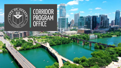
PROPOSED CODE AMENDMENTS FOR MOBILITY PROJECTS IN THE ROW Boards & Commissions Presenter: Susan Daniels May 2022 HISTORIC INVESTMENT IN MOBILITY INFRASTRUCTURE 3 connectivity improved level-of- service for all modes reduction in congestion MOBILITY PRIORITIES COMMUNITY CONSIDERATIONS improved effectiveness of transit operations preservation of existing affordable housing preservation of existing local businesses promotes healthy, equitable and complete communities opportunities for development of new affordable housing opportunities to facilitate mixed- income housing emphasizes livable, walkable, safe and transit- supportive corridors MOBILITY BONDS • • 2016 Bond • 2018 Bond Contract With Voters: Analyze capital project delivery 2020 Bond systems to recommend potential changes to accelerate bond program completion. PROJECT CONNECT 4 CORRIDOR PROGRAM SCALE Corridor Program alone is implementing 50 miles of critical safety and mobility improvements 5 CORRIDOR PROGRAM – FOCUSED ON OUTCOMES Corridor Construction Program Map • 10-15% Mode Shift • Average 25% Reduction in Vehicular Delay • 15%+ Reduction in Crashes • Complete Streets/ Complete Communities • 100 bike route connections • 75 miles of sidewalks or shared-use paths • 120 signal improvements • 13 of Austin’s Top Crash Intersections improved 6 CORRIDOR PROGRAM - MODE SHIFT The Austin Strategic Mobility Plan’s goal for managing traffic congestion is a 50/50 mode share. This means that we could maintain approximately the same number of cars as we have on the road today, while almost doubling in population by 2039. The Corridor Construction Program will achieve an estimated 10-15% mode shift with a reduction of 4.36 million vehicular trips annually. 7 CORRIDOR PROGRAM – CRASH REDUCTION Corridor Construction Program infrastructure is improving safety by an estimated reduction of 200 crashes annually. The Corridor Construction Program is improving 13 of Austin’s Top Crash Intersections across six Council Districts. 8 Austin’s average summer temperatures are expected to increase by at least two degrees by 2040. COMPLETE COMMUNITIES INFRASTRUCTURE Corridor Program improvements include rain gardens, landscape buffers, grass, and trees which all help to improve Austin’s quality of life by lessening exposure to heat. • Installing 2000 trees across multiple roadways • Constructing 22+ rain gardens 9 CORRIDOR PROGRAM – REDUCED EMISSIONS Transportation produces about 36% of all greenhouse gas emissions in the Austin metro area, with a 178% increase since 1990. “Every transportation decision is a climate decision.” – US Transportation Secretary Pete Buttigieg, SXSW 2022 The Corridor Construction Program is reducing emissions annually along 9 corridors by an estimated 20% or …
SPECIAL CALLED MEETING CODES AND ORDINANCES JOINT COMMITTEE MINUTES Thursday, May 5, 2022 The Codes and Ordinances Joint Committee convened in a regular meeting on Thursday, May 5, at 1000 E. 11th St, Street Jones Building, Room 400A, Austin, TX 78702. Vice Chair Hempel called the meeting to order at 6:10 pm. Subcommittee Members in Attendance: Ann Denkler Claire Hempel (Vice Chair) Awais Azhar Todd Shaw Jolene Kiolbassa City Staff in Attendance: Susan Daniels, Corridor Program Office Donna Galati, Project Connect Office Liz Johnston, Watershed Protection Katie Coyne, Watershed Protection CALL TO ORDER 3. NEW BUSINESS a. None. 4. OLD BUSINESS 1. PUBLIC COMMUNICATION: Speakers signed up prior to commencement of the meeting will be allowed to address their concerns regarding items not posted on the agenda. a. None. 2. APPROVAL OF MINUTES a. Approval of the March 16, 2022, meeting minutes. The item was postponed to a future agenda without objection. Facilitator: Commissioner Hempel, Vice Chair of COJC City Attorney: None 1 a. None. 5. POTENTIAL CODE AMENDMENTS: Proposed for Discussion and/or Initiation Potential amendments to the code are offered for discussion and/or possible recommendation for initiation. If initiated, Staff will research the proposal and report back to the subcommittee. a. South Central Waterfront Regulating Plan. Consider initiation of amendments to Title 25 of the City Code related to the South Central Waterfront planning area. City Staff: Greg Dutton, Housing and Planning and Department, (512) 974-3509, greg.dutton@austintexas.gov; (Discussion and/or Possible Action). Greg Dutton went over the need for an amendment to Title 25 to be initiated to implement the South Central Waterfront Regulating Plan, which is a bonus program that will be amended to the LDC, much the way the University Neighborhood Overlay works today. This item was combined with the briefing item on the same topic. A motion was made to recommend that the Planning Commission initiate the item, by Commissioner Azhar, seconded by Commissioner Shaw. Vote: 5-0. (Commissioner Barrera- Ramirez absent). An amendment to the motion was made by Commissioner Kiolbassa, seconded by Commissioner Denkler, vote 5-0 (Commissioner Barrera-Ramirez absent), to add the following items: - - A summary of differences in entitlements between baseline zoning and bonus entitlements - Exploration of possible funding to do outreach and community engagement Exploration of funding for an analysis of costs and benefits of the plan 6. REGULAR AGENDA: Previously Initiated Previously initiated amendments to the code are offered for …
Historic Landmark Commission Applications under Review for May 4, 2022 Meeting This list does not constitute a formal agenda and is subject to change. A final agenda will be posted at least 72 hours prior to the meeting. Public comment will be allowed in-person or remotely by telephone. Registration no later than noon the day before the meeting is required for remote participation. To register for remote participation: • Call or email the board liaison at (512) 974-3393 or preservation@austintexas.gov no later than noon, Tuesday, May 3, 2022 (the day before the meeting). The following information is required: speaker name, item number(s) they wish to speak on, whether they are for/against/neutral, email address and telephone number (must be the same number that will be used to call into the meeting). • Once a request to speak has been made to the board liaison, the information to call on the day of the scheduled meeting will be provided either by email or phone call. • Speakers must call in at least 15 minutes prior to meeting start time in order to speak, late callers will not be accepted and will not be able to speak. • Speakers will be placed in a queue until their time to speak. • Handouts or other information may be emailed to preservation@austintexas.gov by noon the day before the scheduled meeting. This information will be provided to Board and Commission members in advance of the meeting. • The live broadcast may be viewed here: http://www.austintexas.gov/page/watch-atxn- live A.1. A.2. A.3. A.4. B.1. B.2. B.3. Historic zoning applications 1505 Forest Trail – Commission-initiated historic zoning (postponed February 28, 2022) 1617 New York Avenue – Commission-initiated historic zoning (postponed March 28, 2022; applicant-requested postponement to June 1, 2022) 1403 E. Cesar Chavez Street – Commission-initiated historic zoning (postponed March 28, 2022) 301 W. 6th Street – Commission-initiated historic zoning 4314 Avenue H – Hyde Park Local Historic District – addition/remodel 2001 Rosewood – Rosewood Courts – Exterior restoration 2300 Windsor Road – McCrummen-Wroe House – side and rear addition/remodel Historic landmark and historic district applications National Register district permit applications C.1. C.2. C.3. C.4. C.5. C.6. C.7. C.8. C.9. D.1. D.2. D.3. D.4. D.5. D.6. D.7. D.8. 1411 Ethridge Avenue – Old West Austin National Register District – Demolish a contributing building (postponed November 15, 2021) 804 Rutherford Place – Travis Heights – Fairview Park National Register District – …
CITY OF AUSTIN COMMISSION FOR WOMEN REGULAR MEETING Wednesday, May 4, 2022, 12:00 p.m. Austin City Hall, Board & Commission Room, Room 1101 301 West 2nd Street, Austin, Texas 78701 Some members of Commission for Women may be participating by videoconference. The meeting may be viewed online at: http://www.austintexas.gov/page/watch-atxn-live. Public comment will be allowed in-person or remotely by telephone. Speakers may speak up to three minutes on an item only once either in-person or remotely. Registration no later than noon the day before the meeting is required for remote participation. To register call or email the board liaison at 512-974-3261 or email Juanita.martinez@austintexas.gov AGENDA CALL TO ORDER PUBLIC COMMUNICATION: GENERAL The first ten (10) speakers signed up prior to the meeting being called to order will each be allowed three minutes to address their concerns regarding items not posted on the agenda. a. Consider approval of the minutes from the Commission for Women regular meeting on Discussion and possible action regarding updates from the following working groups: 1. APPROVAL OF MINUTES April 6, 2022. 2. OLD BUSINESS a. Homelessness b. Safety c. Health d. Recognition of Equity for Women and Girls a. Discussion and possible action regarding updates from the Joint Inclusion Committee. b. Discussion and possible action regarding 2022 Commission Working Groups. c. Discussion and possible action regarding the City of Austin FY2022 & FY2023 budget. 3. NEW BUSINESS a. Presentation from the City Manager’s Office and Police Research Forum (PERF) regarding Resolution No. 20190131-077 on evaluation of Austin Police Department’s sexual assault investigations. b. Presentation on Homelessness from Officer Dianna Grey, Homeless Strategy. FUTURE AGENDA ITEMS ADJOURNMENT The City of Austin is committed to compliance with the American with Disabilities Act. Reasonable modifications and equal access to communications will be provided upon request. Meeting locations are planned with wheelchair access. If requiring Sign Language Interpreters or alternative formats, please give notice at least 2 days (48 hours) before the meeting date. Please contact Juanita Martinez, Office of Civil Rights, at 512-974-3261 or Juanita.Martinez@austintexas.gov, for additional information; TTY users route through Relay Texas at 711. For more information on the Commission for Women, please contact Juanita Martinez, Office of Civil Rights, at 512-974-3261or Juanita.Martinez@austintexas.gov.
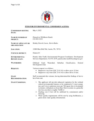
Regular Meeting of the Environmental Commission May 4, 2022 at 6:00 P.M. Permitting and Development Center, Events Center, Room 1406 6310 Wilhelmina Delco Drive, Austin, Texas 78752 Some members of the Environmental Commission will be participating by videoconference. The meeting may be viewed online at: http://www.austintexas.gov/page/watch-atxn-live Public comment will be allowed in-person or remotely by telephone. Speakers may only register to speak on an item once either in-person or remotely and will be allowed up to three minutes to provide their comments. Registration no later than noon the day before the meeting is required for remote participation. To register to speak remotely, call or email the board liaison Kaela Champlin, (512) 974-3443, Kaela.Champlin@austintexas.gov, no later than noon, (the day before the meeting). The following information is required: speaker name, item number(s) they wish to speak on, whether they are for/against/neutral, email address and telephone number (must be the same number that will be used to call into the meeting). COMMISSIONERS: Haris Qureshi (D-1) Rachel Scott (D-2) Pam Thompson (D-3) Melinda Scheira (D-4) Kevin Ramberg (D-8) Chair Audrey Barrett Bixler (D-5) Ana Aguirre (D-9) Colin Nickells (D-6) Richard Brimer (D-10) Jennifer Bristol (D-7) Secretary Perry Bedford (Mayor) Vice-Chair _________________________________________________________________________________ Agenda CALL TO ORDER PUBLIC COMMUNICATION: GENERAL The first 10 speakers who register to speak no later than noon the day before the meeting will be allowed a three-minute allotment to address their concerns regarding items not posted on the agenda. 1 1. 2. 3. 4. APPROVAL OF MINUTES AND ACTION a. Approval of the April 20, 2022 Environmental Commission Regular Meeting Minutes (5 minutes) ITEMS FOR CONSIDERATION AND POSSIBLE ACTION a. Discussion and recommendation of Austin Water Capital Improvement Projects located in the Drinking Water Protection Zone for approval to include in the 5-year Capital spending plan as required by Financial Policy #8—Aurora Pizano, Financial Manager II, Austin Water (15 minutes) b. Briefing on proposed changes to City Land Development Code Title 25 (§ 25-1, § 25-2, § 25-8) to address challenges to the successful design and construction of public mobility projects in the right-of-way—Susan Daniels, Deputy Director, Corridor Program Office. (30 minutes) PUBLIC HEARINGS a. Name: Pinnacle at Wildhorse Ranch, C8-2021-0152 Applicant: Kevin Burks, Kimley Horn & Associates Location: 12000 Blue Bluff Rd, Austin, TX 78724 Council District: District 1 Staff: Pamela Abee-Taulli, Environmental Program Coordinator, Development Services Department Watershed: Gilleland Creek Watershed, Suburban Classification, Desired Development Zone 1. Request …
Memorandum To: Boards and Commissions From: Greg Meszaros, Director, Austin Water Date: March 23, 2022 Subject: Board and Commission and Citizen Review of new Growth-related Capital Improvement Projects in Drinking Water Protection Zone The Austin City Council approved an amendment to Austin Water’s (AW) Financial Policy No. 8 to provide for enhanced Board and Commission and citizen reviews of AW’s new growth-related capital improvement projects (CIP) located in the Drinking Water Protection Zone (DWPZ). The previous ordinance (No. 20130117-017) took effect on January 28, 2013 and on August 11, 2021 ordinance (No. 20210811-001) amended the DWPZ financial policy. AW is presenting the new growth-related projects to Boards and Commissions as set forth in the ordinance. The revised Financial Policy No. 8 reads as follows: Capital improvement projects for new water and wastewater treatment plants, capital expansions, and growth-related projects that are located in the Drinking Water Protection Zone (DWPZ) will be identified and submitted, as part of the annual budget process, to the following Boards and Commissions: Water and Wastewater Commission, Resource Management Commission, and the Environmental Board. These Boards and Commissions will review growth-related DWPZ capital projects spending plans, obtain Board and Commission and citizen input, review consistency with Imagine Austin Comprehensive Plan, review effect on growth within the DWPZ, and make recommendations on project approval for inclusion in Austin Water's five-year capital spending plan. This summer, AW representatives will be distributing a brief report to the Commissions on the CIP projects located in the DWPZ related to the financial policy. Attachments: CIP Subprojects Summary CIP Subprojects Supplemental Information and Map The City of Austin is committed to compliance with the Americans with Disabilities Act. Reasonable modifications and equal access to communications will be provided upon request. Austin Water Infrastructure Management Financial Policy No. 8 Drinking Water Protection Zone Projects Summary FY23-27 CIP Plan Development Each year, as part of the City of Austin Budget approval process, Austin Water submits a plan for the capital improvements program (CIP) spending for the upcoming five-year period. Austin Water’s FY23-27 CIP Plan includes projects located across the Austin metropolitan area, including the Drinking Water Protection Zone (DWPZ). In compliance with Austin Water’s Financial Policy No. 8, the capital improvement projects for new water and wastewater treatment plants, capital expansions, and growth related projects that are located in the DWPZ are presented below for consideration by City of Austin Boards and Commissions. These …
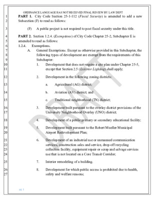
1 2 3 4 5 6 7 8 9 10 11 12 13 14 15 16 17 18 19 20 21 22 23 24 25 26 27 ORDINANCE LANGUAGE HAS NOT RECEIVED FINAL REVIEW BY LAW DEPT PART 1. City Code Section 25-1-112 (Fiscal Security) is amended to add a new Subsection (F) to read as follows: (F) A public project is not required to post fiscal security under this title. PART 2. Section 1.2.4. (Exemptions) of City Code Chapter 25-2, Subchapter E is amended to read as follows: 1.2.4. Exemptions. A. General Exemptions. Except as otherwise provided in this Subchapter, the following types of development are exempt from the requirements of this Subchapter: 1. Development that does not require a site plan under Chapter 25-5, except that Section 2.5 (Exterior Lighting) shall apply; 2. Development in the following zoning districts: Agricultural (AG) district; Aviation (AV) district; and a. b. c. Traditional neighborhood (TN) district; 3. Development built pursuant to the overlay district provisions of the University Neighborhood Overlay (UNO) district; 4. Development of a public primary or secondary educational facility; 5. Development built pursuant to the Robert Mueller Municipal Airport Redevelopment Plan; 6. Development of an industrial use or unmanned communication services, construction sales and service, drop-off recycling collection facility, equipment repair or scrap and salvage services use that is not located on a Core Transit Corridor; 7. Interior remodeling of a building. 8. Development for which public access is prohibited due to health, safety and welfare reasons; pg. 1 1 2 3 4 5 6 7 8 9 10 11 12 13 14 15 16 17 18 19 20 21 22 23 24 25 26 ORDINANCE LANGUAGE HAS NOT RECEIVED FINAL REVIEW BY LAW DEPT 9. Development of a warehouse if less than 25% of the gross floor area is used for a non-industrial use; 10. Sidewalk, shared use and urban trail projects managed by the City of Austin and processed under the City's General Permit program which are undertaken for the purpose of bringing existing facilities into compliance with the Americans With Disabilities Act; 11. A public mobility project in the right-of-way; and 12.[11.] Development built pursuant to any of the following adopted regulating plans: a. Transit-Oriented District Station Area Plan; b. North Burnet/Gateway (NBG) District; c. East Riverside Corridor; d. Waller Creek District; e. Downtown Austin Plan; or f. Airport Boulevard Corridor Plan. PART 3. City …
RESOLUTION NO. 20220303-028 WHEREAS, in August 2016, City Council approved Resolution No. 20160818-07 4 that expressed Council's intent to contract with voters for a Mobility Bond election in November 2016 and directed the City Managerto analyze existing capital project delivery systems and processes in order to recommend potential changes and resource requirements to complete the bond program within eight years from initiation; and WHEREAS, in March 2019, City Council approved Resolution No. 20190328-040 that affirmed the City of Austin's desire to construct as many miles of progressive multi-modal mobility infrastructure as quickly as it can to facilitate congestion relief, safety, and environmental stewardship, and encouraged the City Manager to form a steering committee of representatives from relevant departments to align resources, priorities, and policies that support an accelerated timetable for planned bicycle, scooter, transit, sidewalks, and tier one urban trail and, infrastructure projects; WHEREAS, in August 2019, City Council approved Resolution N o. 20190808-081 that directed the City Manager to analyze and report on options for the City to leverage resources to support the creation, operation, and maintenance of a high-capacity transit system; and, WHEREAS, in August 2020, City Council approved Resolution N o. 20200807-003 that expressed Council's intent to contract with the voters for a citywide rapid transit system (to be known as "Project Connect") that will include four MetroRapid lines to be constructed and operational within five years, and two light rail lines to be constructed within and operational ten years; and, Page 1 of 5 WHEREAS, in August 2020, City Council approved Resolution No. 20200812-011 that expressed Council's intent to contract with the voters fora Mobility Bond election in November 2020, and directed the City Manager to analyze existing capital project delivery systems and processes in order to recommend potential changes and resource requirements to accelerate project delivery and maximize the number ofprojects to be completed within six years; and, WHEREAS, in October 2021, City Council approved Resolution No. 20211029-003 that directed the City Manager to review City Code, including, but not limited to, the Land Development Code, Criteria Manuals, and permitting procedures to identify impediments to the design, construction, implementation, and operation of Project Connect, and to present any Code amendments necessary to City Council no later than April 2022; and, WHEREAS, public mobility projects in the right-of-way offer tremendous community benefits, including improved multimodal access and accessibility for individuals with disabilities, enhanced life safety, greater …
Pamela Abee-Taulli Environmental Program Coordinator Development Services Department PINNACLE AT WILDHORSE RANCH 12000 BLUE BLUFF RD, AUSTIN 78724 C8-2021-0152 PROJECT LOCATION Site Location Austin ETJ Austin City Limits Edwards Aquifer Recharge Zone Edwards Aquifer Contributing Zone 2 This product is for informational purposes and may not have been prepared for or be suitable for legal, engineering, or surveying purposes. It does not represent an on-the- ground survey and represents only the approximate relative location of property boundaries. This product has been produced by the Watershed Protection Department for the sole purpose of geographic reference. No warranty is made by the City of Austin regarding specific accuracy or completeness. [0510Miles PROJECT LOCATION Site Location 3 [ PROPERTY DATA • Gilleland Creek Watershed • Suburban Classification • Desired Development Zone • Full Purpose Jurisdiction • Not located over Edwards Aquifer Recharge Zone • 2 Wetland Critical Environmental Features • Council District 1 4 [ THE DEVELOPMENT • Single family residential lots. • Water quality and detention facilities. • Right of way. 5 [ VARIANCE REQUESTS § 25-8-341 - CUT REQUIREMENTS. (A) Cuts on a tract of land may not exceed four feet of depth. 1. The variance request is to allow cut over 4 feet to15 feet. § 25-8-342 - FILL REQUIREMENTS. (A) fill on a tract of land may not exceed four feet of depth. 2. The variance request is to allow fill over 4 feet to 15 feet. 6 VARIANCE REQUESTS Grading 1. Cut to 15 2. Fill to 15 7 [ VARIANCE REQUESTS Grading 1. Cut to 15 2. Fill to 15 8 [ VARIANCE REQUESTS Grading 1. Cut to 15 2. Fill to 15 9 [ VARIANCE REQUESTS Grading 1. Cut to 15 2. Fill to 15 10 [ VARIANCE REQUESTS BACKGROUND Constraints • Slopes at or exceeding 15 percent grade. Site Location 11 [ VARIANCE REQUESTS BACKGROUND Constraints • Slopes at or exceeding 15 percent grade. • Two wetland Critical Environmental Features (CEFs) Site Location Wetland Wetland buffer 12 [ • Similar variances have been granted for projects with similar code Is necessitated by topographic features, not design choice; Is the minimum deviation from the code; and Is unlikely to result in harmful environmental consequences. • Water quality will be equal to water quality without the variance. VARIANCE RECOMMENDATION requirements. The variance • • • • 13 VARIANCE CONDITIONS Staff recommends the variances, with the following conditions. …
ITEM FOR ENVIRONMENTAL COMMISSION AGENDA COMMISSION MEETING DATE: May 4, 2022 NAME & NUMBER OF PROJECT: Pinnacle at Wildhorse Ranch C8-2021-0152 NAME OF APPLICANT OR ORGANIZATION: Kimley Horn & Assoc., Kevin Burks LOCATION: 12000 Blue Bluff Rd, Austin, TX, 78724 COUNCIL DISTRICT: District #1 ENVIRONMENTAL REVIEW STAFF: WATERSHED: Pamela Abee-Taulli, Environmental Program Coordinator, Development Services Department, 512.974.1879, pamela.abee-taulli@austingexas.gov Gilleland Creek Watershed, Suburban Classification, Desired Development Zone REQUEST: Variance request is as follows: STAFF RECOMMENDATION: STAFF CONDITION: • Request to vary from LDC 25-8-341 to allow cut to 15 feet. • Request to vary from LDC 25-8-342 to allow fill to 15 feet. Staff recommends this variance, having determined the findings of fact to have been met. 1. The applicant will provide enhanced vegetation for the wetland critical environmental features, to be comprised of 1 (one) canopy tree and 2 (two) understory trees per 700 square feet, to be planted in clusters, with plants no closer than 3feet on center, in a generally tree-less area that is roughly 70,000 sf. 2. Grading over 8 feet will be stabilized by containment and/or terracing. 3. Water quality requirements will be met by using biofiltration, a green storm water quality infrastructure. Page 1 of 24 Development Services Department Staff Recommendations Concerning Required Findings Project Name: Ordinance Standard: Variance Request: Pinnacle at Wildhorse Ranch Comprehensive Watershed Ordinance as modified by Planned Unit Development (PUD) Ordinance 020214-28 Request to vary from LDC 25-8-341 to allow cut to 15 feet. Include an explanation with each applicable finding of fact. A. Land Use Commission variance determinations from Chapter 25-8-41 of the City Code: 1. The requirement will deprive the applicant of a privilege available to owners of similarly situated property with approximately contemporaneous development subject to similar code requirements. Grading variances have been deemed appropriate under similar Yes development circumstances for sites with multiple constraints. Blue Bluff/Saddle Ridge at Wildhorse Ranch (C8-2020-0033) also received variances for cut to 15 feet and fill to 15 feet. Both sites have topographical challenges, including slopes near or exceeding a grade of fifteen percent. This site has two wetland features as well. These constraints make it difficult to comply with Transportation Criteria Manual and Americans with Disabilities requirements for slopes, stopping sight distance, and block length maximums without variances to the Land Development Code grading regulations. 2. The variance: a) Is not necessitated by the scale, layout, construction method, or other design …
ITEM FOR ENVIRONMENTAL COMMISSION AGENDA COMMISSION MEETING DATE: May 4, 2022 NAME & NUMBER OF PROJECT: NAME OF APPLICANT OR ORGANIZATION: LOCATION: COUNCIL DISTRICT: ENVIRONMENTAL REVIEW STAFF: WATERSHED: REQUEST: STAFF RECOMMENDATION: STAFF CONDITION: Case No. C814-2009-0139.03; Bull Creek PUD Amendment #4 David Armbrust, Armbrust & Brown 5305, 5400, 5404, 5408, 5505, Paradox Cove; 4909, 4915-1/2, 4929 FM 2222 Road District 10 Leslie Lilly, Environmental Program Coordinator, Watershed Protection Department, Leslie.Lilly@austintexas.gov Bull Creek Watershed, Water Supply Suburban, Drinking Water Protection Zone To amend a Planned Unit Development (PUD) Staff recommended with conditions 1. This applicant completes the restoration plan prior to the conversion of the property to civic use as established by the PUD (and referenced in site plan SP- 2021-0249D) such that any further development or redevelopment is subject to current code at the time of site development permit application. 2. This project shall comply with 25-8, except for the relevant code modifications included in the PUD amendment. 3. This project shall comply with the environmental superiority elements included in the PUD amendment. Bull Creek PUD 5305, 5400, 5404, 5408, 5505, Paradox Cove; 4909, 4915-1/2, 4929 FM 2222 Road C814-2009-0139.03 (PUD Amendment) Leslie Lilly Environmental Program Coordinator Watershed Protection Planned Unit Development Amendment • A Planned Unit Development (PUD) is a type of site development and regulatory process established by city ordinance for a tract of land. • The Bull Creek PUD was approved by council in 2009, designating the type of development allowed for this single-family residential property. • The applicant is requesting a PUD Amendment to revise the Land Use Plan (exhibit C) and Restoration plan (exhibit F) for the property. Site Conditions • Located in Full Purpose Jurisdiction • The site is located at the confluence of Bull Creek and Lake Austin • In both the Bull Creek and Lake Austin Watersheds Environmental Features • The property has both rimrock CEFs and wetland CEFs • The SW portion of the property is in the 100-year floodplain • The SW bank was impounded before 1958 • The shoreline has a fringe of large cypress trees • The southern section of the property is dominated by bermuda grass lawn with heritage pecan trees Requested Code Modifications 1. 2. 3. 4. 5. Section 25-8-341 modified to allow cut to exceed 4 feet (up to 8 feet) to allow for the construction of habitat pond as shown in Exhibit J of …
ZONING CHANGE REVIEW SHEET Amendment #3 DISTRICT: 10 CASE: C814-2009-0139.03 – Bull Creek PUD ZONING FROM: PUD ADDRESS: 5305, 5400, 5404, 5408, 5505 Paradox Cove; 4909, 4915-1/2, 4929 FM 2222 Road SITE AREA: 54.70 acres PROPERTY OWNER: David G. Booth, Trustee for the David Booth Revocable Trust AGENT: Armbrust & Brown, PLLC (David Armbrust) TO: PUD, to change conditions of zoning CASE MANAGER: Wendy Rhoades (512-974-7719, wendy.rhoades@austintexas.gov) STAFF RECOMMENDATION: The Staff recommendation is to grant an amendment to planned unit development (PUD) district zoning as outlined in the redlined draft PUD amendment ordinance, and as shown in Exhibit C – the revised Land Use Plan, and supporting Exhibits F, J, K, N, and O. For a summary of the basis of Staff’s recommendation, please see pages 2 - 6. ENVIRONMENTAL COMMISSION ACTION: May 4, 2022: ZONING AND PLATTING COMMISSION ACTION: May 17, 2022: April 19, 2022: APPROVED A POSTPONEMENT REQUEST BY STAFF TO MAY 17, 2022, BY CONSENT March 1, 2022: APPROVED A POSTPONEMENT REQUEST BY STAFF TO APRIL 19, 2022 [J. KIOLBASSA; A. DENKLER – 2ND] (11-0) [H. SMITH; A. DENKLER – 2ND] (9-0) S. BOONE; R. WOODY – ABSENT January 18, 2022: APPROVED A POSTPONEMENT REQUEST BY STAFF TO MARCH 1, 2022 [H. SMITH; C. ACOSTA – 2ND] (10-0) R. WOODY – OFF THE DAIS August 4, 2020: APPROVED AN INDEFINITE POSTPONEMENT REQUEST BY STAFF [H. SMITH; D. KING – 2ND] (10-0) ONE VACANCY ON THE DAIS C814-2009-0139.03 Page 2 CITY COUNCIL ACTION: To be scheduled ORDINANCE NUMBER: ISSUES: The Applicant has discussed the proposed PUD amendment with Courtyard Homeowners Association, Cat Mountain Homeowners Association, North West Austin Civic Association, and 2222 Coalition of Neighborhood Associations (CONA). The Applicant is in agreement with the Staff recommendation. EXHIBITS AND ATTACHMENTS TO THE STAFF REPORT: Exhibits A and A-1: Zoning Map and Aerial Exhibit B: Applicant’s Summary Letter; Redlined, draft PUD Amendment Ordinance; Tier 1 / Tier 2 Chart; and Code Modifications Revised Exhibits to the PUD: Exhibit C: Land Use Plan Exhibit F: Restoration Plan and Details Exhibit J: Cut and Fill Exhibit K: Construction on Slopes Exhibit N: Critical Environmental Features Exhibit O: Tree Protection Attachment A: Environmental Commission support material Correspondence Received CASE MANAGER COMMENTS: The proposed third amendment to the Bull Creek Planned Unit Development (PUD) consists of a single family residence with several accessory structures located at the confluence of Lake Austin and Bull Creek. …
Versión en español a continuación. Historic Landmark Commission Meeting Wednesday, May 4, 2022, 6:00 PM Public comment will be allowed in-person or remotely by telephone. Registration no later than noon the day before the meeting is required for remote participation (Tuesday, May 3 by noon). To speak remotely at the Historic Landmark Commission Meeting, members of the public must: Call or email the board liaison at (512) 974-3393 or preservation@austintexas.gov no later than noon, Tuesday, May 3rd (the day before the meeting). The following information is required: speaker name, item number(s) they wish to speak on, whether they are for/against/neutral, email address and telephone number (must be the same number that will be used to call into the meeting). Once a request to speak has been made to the board liaison, the information to call on the day of the scheduled meeting will be provided either by email or phone call. Speakers must call in at least 15 minutes prior to meeting start time in order to speak, late callers will not be accepted and will not be able to speak. Speakers will be placed in a queue until their time to speak. Handouts or other information may be emailed to preservation@austintexas.gov by noon the day before the scheduled meeting. This information will be provided to Board and Commission members in advance of the meeting. If the meeting is broadcast live, it may be viewed here: http://www.austintexas.gov/page/watch-atxn-live Reunión del Historic Landmark Commission FECHA de la reunion (4 de mayo, 2022) Se permitirán comentarios públicos en persona o de forma remota por teléfono. Se requiere registro a más tardar al mediodía del día anterior a la reunión para la participación remota. (Domingo 4 de mayo al mediodía). Para hablar de forma remota en la reunión, los miembros del público deben: Llame o envíe un correo electrónico al enlace de la junta en (512) 974-3393 or preservation@austintexas.gov a más tardar al mediodía (el día antes de la reunión). Se requiere la siguiente información: nombre del orador, número (s) de artículo sobre el que desean hablar, si están a favor / en contra / neutral, dirección de correo electrónico (opcional) y un número de teléfono (debe ser el número que se utilizará para llamar ). Una vez que se haya realizado una solicitud para hablar con el enlace de la junta, la información para llamar …
HISTORIC LANDMARK COMMISSION MONDAY, February 28, 2022 – 6:00 PM CITY HALL - Council Chambers 301 W. 2nd Street Austin, TX 78701 Some members of the Commission may be participating by videoconference. The meeting may be viewed online at: http://www.austintexas.gov/page/watch-atxn-live. COMMISSION MEMBERS: x Terri Myers, Chair x Ben Heimsath, Vice Chair x Anissa Castillo x Witt Featherston x Kevin Koch x Carl Larosche x Kelly Little x Trey McWhorter x Blake Tollett x Beth Valenzuela x Caroline Wright DRAFT MINUTES CALL TO ORDER PUBLIC COMMUNICATION: GENERAL The first (10) speakers who register to speak no later than noon the day before the meeting will be allowed a three-minute allotment to address their concerns regarding items not posted on the agenda. Clifton Ladd spoke on the many demolitions happening in the Travis Heights-Fairview Park National Register district. Susan Armstrong Fischer spoke on the notification process for public hearings for demolitions in the Travis Heights-Fairview Park National Register district. 1. APPROVAL OF MINUTES A. January 24, 2022 – Offered for consent approval MOTION: Approve the minutes, per passage of the consent agenda, on a motion by Commissioner Koch. Commissioner Larosche seconded the motion. Vote: 11-0. 1 2. PRESENTATIONS, DISCUSSION, AND POSSIBLE ACTION A. No items. 3. PUBLIC HEARINGS A. Discussion and Possible Action on Applications for Historic Zoning, Discussion and Action on Applications for Historic District Zoning, and Requests to Consider Initiation of Historic Zoning Cases A.1. PR-2021-137925 – 1505 Forest Trl. – Consent postponement to April 25, 2022 Council District 10 Proposal: Commission-initiated historic zoning. Applicant: Carolina Escamilla City Staff: Elizabeth Brummett, Historic Preservation Office, 512-974-1264 Staff Recommendation: Grant the applicant’s postponement request. MOTION: Postpone the public hearing to April 25, 2022, per passage of the consent postponement agenda, on a motion by Commissioner Larosche. Commissioner Koch seconded the motion. Vote: 11-0. A.2. PR-2021-195456 – 1617 New York Ave. – Consent postponement to March 28, 2022 Council District 1 Proposal: Commission-initiated historic zoning. Applicant: Holly Arthur City Staff: Kalan Contreras, Historic Preservation Office, 512-974-2727 Committee Feedback: Relocate the chimney to avoid disrupting the existing gable end and window. Retain the historic-age window for later replacement. Staff Recommendation: Grant the applicant’s postponement request. MOTION: Postpone the public hearing to March 28, 2022, per passage of the consent postponement agenda, on a motion by Commissioner Larosche. Commissioner Koch seconded the motion. Vote: 11-0. B. Discussion and Possible Action on Applications for Certificates of …
HISTORIC LANDMARK COMMISSION MONDAY, March 28, 2022 – 6:00 PM City of Austin Permitting and Development Center 6310 Wilhelmina Delco Dr, Room 1405 Austin, TX 78752 Some members of the Commission may be participating by videoconference. The meeting may be viewed online at: http://www.austintexas.gov/page/watch-atxn-live. COMMISSION MEMBERS: x x x x x x Terri Myers, Chair Ben Heimsath, Vice Chair Anissa Castillo Witt Featherston Kevin Koch Carl Larosche x x x x x Kelly Little Trey McWhorter Blake Tollett Beth Valenzuela Caroline Wright DRAFT MINUTES CALL TO ORDER PUBLIC COMMUNICATION: GENERAL The first (10) speakers who register to speak no later than noon the day before the meeting will be allowed a three-minute allotment to address their concerns regarding items not posted on the agenda. Susan Armstrong Fischer spoke on the City of Austin notification policies and Austin History Center accessibility in reference to the Historic Landmark Commission document posting schedule. 1. APPROVAL OF MINUTES A. February 28, 2022 – Offered for consent approval MOTION: Approve the minutes, per passage of the consent agenda, on a motion by Commissioner Larosche. Commissioner Koch seconded the motion. Vote: 11-0. 1 2. PRESENTATIONS, DISCUSSION, AND POSSIBLE ACTION A. Revised 2022 Meeting Schedule Presenter: Elizabeth Brummett MOTION: Approve the revised 2022 meeting schedule, on a motion by Commissioner Heimsath. Commissioner Larosche seconded the motion. Vote: 11-0. B. Briefing on Art in Public Places Presenter: Frank Wick 3. PUBLIC HEARINGS A. Discussion and Possible Action on Applications for Historic Zoning, Discussion and Action on Applications for Historic District Zoning, and Requests to Consider Initiation of Historic Zoning Cases A.1. PR-2021-195456 – 1617 New York Ave. – Applicant-requested postponement (postponed February 28, 2022) Council District 1 Proposal: Commission-initiated historic zoning. Applicant: Holly Arthur City Staff: Kalan Contreras, Historic Preservation Office, 512-974-2727 Committee Feedback: Relocate the chimney to avoid disrupting the existing gable end and window. Retain the historic-age window for later replacement. Staff Recommendation: Postpone the public hearing to the commission’s next meeting on May 4, 2022 at City Hall Council Chambers. MOTION: Postpone the public hearing to May 4, 2022, per passage of the consent postponement agenda, on a motion by Commissioner Koch. Commissioner Heimsath seconded the motion. Vote: 11-0. A.2. PR-2021-014784 – 1403 E. Cesar Chavez Street. – Applicant-requested postponement Council District 3 Proposal: Commission-initiated historic zoning. Applicant: Robert Abbott City Staff: Kimberly Collins, Historic Preservation Office, 512-978-1801 Staff Recommendation: Postpone the public hearing to …
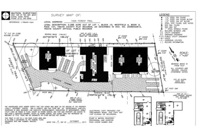
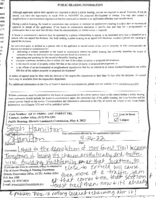
ZONING CHANGE REVIEW SHEET A.1 – 1 CASE NUMBER: TBD HLC DATE: December 17, 2021 PC DATE: January 24, 2022 February 28, 2022 May 4, 2022 APPLICANT: Historic Landmark Commission (owner-opposed) HISTORIC NAME: Charles E. Green House (El Rancho Verde) WATERSHED: Johnson Creek NEIGHBORHOOD PLAN: West Austin Neighborhood Group ADDRESS OF PROPOSED ZONING CHANGE: 1505 Forest Trail ZONING CHANGE: MF-3-NP to MF-3-H-NP COUNCIL DISTRICT: 10 STAFF RECOMMENDATION: Staff finds that the house meets the criteria for landmark designation for its unique architecture, landscape features, and historical association with Charles E. Green, editor of the Austin American-Statesman for over 30 years. The commission may want to consider the character of Green’s writings in making their recommendation. In consideration of the applicant’s withdrawal of the demolition permit application and intent to retain the historic house while constructing additional housing on site, staff recommends that the Commission not pursue historic zoning. QUALIFICATIONS FOR LANDMARK DESIGNATION: Architecture, historical associations, and landscape feature HISTORIC LANDMARK COMMISSION ACTION: May 4, 2022: April 25, 2022: Meeting rescheduled. Case re-notified for May 4, 2022. February 28, 2022: Postpone the public hearing to April 25, 2022, per passage of the consent postponement agenda, on a motion by Commissioner Larosche; Commissioner Koch seconded the motion. Vote: 11-0. January 24, 2022: Postpone the public hearing to February 28, 2022, on a motion by Commissioner Heimsath, seconded by Commissioner Tollett. Vote: 9-0, Commissioners Castillo and Little were absent. December 17, 2021: Initiate historic zoning based on architecture and historical associations, and reopen the public hearing, on a motion by Commissioner Koch, seconded by Commissioner Tollett. Vote: 10-0, Commissioner Wright was absent. PLANNING COMMISSION ACTION: DEPARTMENT COMMENTS: The 2011 MoPac reconnaissance survey report lists the property as contributing to a potential historic district. Note that the Historic Landmark Commission previously conducted a public hearing for demolition of this property but did not reach a resolution. The case was initially heard on January 23, 2017 (see staff report). After multiple applicant-requested postponements, the case did not reappear on the September 25, 2017 agenda. CITY COUNCIL ACTION: CASE MANAGER: Elizabeth Brummett PHONE: 512-974-1264 NEIGHBORHOOD ORGANIZATIONS: Austin Independent School District, Austin Lost and Found Pets, Austin Neighborhoods Council, Central West Austin Neighborhood Plan Contact Team, Friends of Austin Neighborhoods, Neighborhood Empowerment Foundation, Preservation Austin, SELTexas, Save Barton Creek Assn., Save Historic Muny District, Sierra Club, Austin Regional Group, TNR BCP – Travis County Natural Resources, Tarrytown …