ZONING CHANGE REVIEW SHEET CASE: 2002 Manor Road Rezoning (C14-2024-0077) DISTRICT: 9 ADDRESS: 2002 Manor Road ZONING FROM: CS-V-CO-NP TO: CS-V-DB90-CO-NP SITE AREA: approximately 0.66 acres (approximately 28,750 square feet) PROPERTY OWNER: Colonnetta Family Partnership AGENT: Thrower Design, LLC (Ron Thrower) CASE MANAGER: Jonathan Tomko (512) 974-1057, jonathan.tomko@austintexas.gov STAFF RECOMMEDATION: Staff recommends granting general commercial services-vertical mixed use building- density bonus 90-conditional overlay-neighborhood plan (CS-V-DB90-CO-NP) combining district zoning. As established in Ordinance No. 020801-92 the conditional overlay would prohibit drive- in service as an accessory to commercial uses. The conditional overlay would conditionally allow these 19 uses: - Automotive repair services - Building maintenance services - Business or trade school - College and university facilities - Communication service facilities - Communications services - Community recreation (private) - Electronic prototype assembly - Exterminating services - Hotel-motel - Indoor entertainment - Indoor sports and recreation - Laundry services - Local utility services - Off-site accessory parking - Outdoor sports and recreation - Pet services - Plant nursery - Veterinary services The conditional overlay would prohibit these 22 uses: - Agricultural sales and services - Adult oriented businesses - Automotive rentals - Automotive sales - Automotive washing (of any type) - Building maintenance services - Maintenance and service facilities - Monument retail services - Pawn shop services - Service station - Vehicle storage - Campground - Commercial blood plasma center - Commercial off-street parking - Construction sales and services - Convenience storage - Drop-off recycling collection facilities - Employee recreation - Equipment repair services - Equipment sales - Kennels - Limited warehousing and distribution For a summary of the basis of Staff’s recommendation, please see the basis of recommendation section below. C14-2024-0077 2 PLANNING COMMISSION ACTION / RECOMMENDATION: October 8, 2024: Neighborhood postponement request to November 12, 2024 granted. November 12, 2024: Case is scheduled to be heard by Planning Commission. CITY COUNCIL ACTION: TBD ORDINANCE NUMBER: N/A ISSUES: Rezoning: In December 2023, Ordinance No. 20220609-080, Ordinance No. 20221201-056 and Ordinance No. 20221201-055 were invalidated. On March 11, 2024, Ordinance No. 20240229-073, was enacted to create the “DB90” combining district, which amended City Code Title 25 (Land Development) to create a new zoning district for a density bonus program that grants 30 feet in height above the base zoning district, to a maximum of 90 feet, and modifies site development regulations including compatibility standards. Subsequently, the applicant submitted this new rezoning application to …
ZONING CHANGE REVIEW SHEET CASE: C14-2024-0139 (Rezoning for 11501 Burnet Road - City Initiated) ADDRESS: 11501 Burnet Road DISTRICT: 7 ZONING FROM: NBG-TOD(Gateway Zone)-NP TO: NBG-TOD(Gateway Zone)-NP* *To change a condition of zoning to remove Part 5 of zoning Ordinance No. 20180628-088. SITE AREA: 65.91 acres PROPERTY OWNER: Hitachi Vantara LLC, Lenovo US Inc, Broadmoor Austin Associates, HCL America Inc., CISCO Systems, New York Life Insurance, Clifton Larson Allen LLP, Brandywine Property, One Uptown Office Property LP, Kyndryl Inc and IBM Corporation APPLICANT/AGENT: City of Austin – Planning Department (Sherri Sirwaitis) CASE MANAGER: Sherri Sirwaitis (512-974-3057, sherri.sirwaitis@austintexas.gov) STAFF RECOMMEDATION: Staff recommends NBG-TOD(Gateway Zone)-NP, North Burnet/Gateway-Transit Oriented Development-Gateway Zone-Neighborhood Plan Combining District, zoning, to change a condition of zoning to remove conditions in the current zoning ordinance that state: A. The maximum height of a building or structure on the Property located within 200 feet of the Neighborhood Residential (NR) subdistrict shall be limited to 120 feet. B. The Property shall be developed according to the commercial mixed use (CMU) subdistrict regulations, unless a Capital Metropolitan Transportation Authority (Cap Metro) Commuter Rail Station is proposed arid construction commenced. Upon issuance to the contractor of a notice to proceed for the construction of a Cap Metro Commuter Rail Station on or adjacent to the Property, the Property may be developed in compliance with transit-oriented development (TOD) Gateway zoning subdistrict regulations. PLANNING COMMISSION ACTION / RECOMMENDATION: November 12, 2024 CITY COUNCIL ACTION: December 12, 2024 ORDINANCE NUMBER: C14-2024-0139 ISSUES: N/A CASE MANAGER COMMENTS: 2 The site under consideration is currently developed with an office complex (Broadmoor) containing seven-buildings with 1.1 million square feet of office space, a new office 348,000 sq. ft. structure known as One Uptown and a new 13-story residential tower with 341 apartment units (Solaris House). This Broadmoor campus is located within the North Burnet/Gateway Combined Neighborhood Planning Area. The property was originally developed for IBM, which has been the sole occupant since the campus was constructed in 1991. The site is located at the southeast corner of Burnet Road and Gault Lane and is zoned NBG with a Transit Oriented Development-Gateway Zone subdistrict designation (NBG- TOD-Gateway Zone) (please see Figure 4-1 TOD: NBG Zoning District General Site Development Standards – Attachment C). The tracts of land to the north contain a vacant lot, a cell tower and a multifamily use (Radius at the Domain Apartments). To the south there …
ZONING CHANGE REVIEW SHEET CASE: C14-2024-0129 (Burnet and Rutland) DISTRICT: 7 ADDRESS: 9901 and 10025 Burnet Road and 2416, 2500, 2500 1/2, 2502, 2510 and 2522 1/2 Rutland Drive ZONING FROM: NBG-CMU-NP, NBG-WMU-NP TO: NBG-CMU(Gateway Zone)-NP SITE AREA: 5.80 acres PROPERTY OWNER: Marquardt Family LP, Burnet Road Properties LLC, Get Investments LLC et al, Sanford Gottesman & Thomas D Simmons, Jr., Crow-Gottsman-Shafer #2 AGENT: Drenner Group, PC (Amanda Swor) CASE MANAGER: Sherri Sirwaitis (512-974-3057, sherri.sirwaitis@austintexas.gov) STAFF RECOMMENDATION: Staff recommends NBG-CMU(Gateway)-NP, North Burnet/Gateway-Commercial Mixed Use-Gateway Zone-Neighborhood Plan, district zoning. PLANNING COMMISSION ACTION / RECOMMENDATION: October 22, 2024: Approved staff's recommendation NBG-CMU(Gateway)-NP zoning on consent (13-0); A. Woods-1st, F. Maxwell-2nd. November 12, 2024: CITY COUNCIL ACTION: November 21, 2024 ORDINANCE NUMBER: C14-2024-0129Page 1 of 18 ISSUES: Due to a posting error on the October 22, 2024 Planning Commission agenda, this case will need to be reconsidered at the November 12, 2024 Planning Commission meeting. CASE MANAGER COMMENTS: The property in question consists of 5.80 acres that make up of six lots developed with restaurant (Turnstile Coffee Beer Cocktails and Burgers), commercial warehouse (The Steam Team), retail and office (formerly High-Tech Flooring & Design), billboard, and office/ warehouse (Capital Scientific, Inc. Lab Supplies) uses and a surface parking lot located at the northeast intersection of Burnet Road and Rutland Drive. The lots to the north are developed with office/warehouse uses (McKalla Business Park) zoned NBG-CMU-NP. To the south, across Rutland Drive, there is a restaurant, a retail center and a multi-tenant office/warehouse use (Rutland 9 Office Center) zoned NBG-CMU-NP. The lot to the east is multi-tenant office building (Epoch Building) zoned NBG-CMU(Gateway)-NP. Across Burnet Road to the west, there is a research and development use (University of Texas JJ Pickle Research Campus) zoned P. The applicant is requesting to rezone the property from NBG-NP (CMU Subdistrict) to NBG- NP (CMU-Gateway Zone Subdistrict) to allow for the development of a residential project with associated ground floor uses (please see Applicant’s Request Letter-Exhibit C). The CMU subdistrict allows an FAR of 3:1 and a maximum building height of up to 180 feet, with development bonuses. However, the CMU-Gateway Zone subdistrict allows for an FAR of 8:1 and a maximum building height of up of 308 feet, with development bonuses (please see North Burnet Gateway - CMU subdistrict General Site Development Standards-Exhibit D). Therefore, the proposed CMU-Gateway Zone subdistrict will allow for higher height and density …
ZONING CHANGE REVIEW SHEET DISTRICT: 4 TO: CS-MU-V-DB90-NP CASE: C14-2024-0138 (Burnet & 183 DB90) ADDRESS: 8909, 9030-1/2 and 9034 Burnet Road ZONING FROM: CS-MU-V-NP SITE AREA: 2.57 acres (34,356 sq. ft.) PROPERTY OWNER: PCD BURNET LTD (PCD BURNET LLC) (Peter L. Donovan, Manager) APPLICANT/AGENT: Armbrust & Brown, PLLC (Michael J. Whellan) CASE MANAGER: Sherri Sirwaitis (512-974-3057, sherri.sirwaitis@austintexas.gov) STAFF RECOMMEDATION: Staff recommends CS-MU-V-DB90-NP, General Commercial Services-Mixed Use- Vertical Mixed Use Building-Density Bonus 90-Neighborhood Plan Combining District, zoning. PLANNING COMMISSION ACTION / RECOMMENDATION: November 12, 2024 CITY COUNCIL ACTION: ORDINANCE NUMBER: C14-2024-0138 2 ISSUES: In December 2023, Ordinance No. 20220609-080, Ordinance No. 20221201-056 and Ordinance No. 20221201-055 were invalidated. On March 11, 2024, Ordinance No. 20240229- 073, was enacted to create the “DB90” combining district, which amended City Code Title 25 (Land Development) to create a new zoning district for a density bonus program that grants 30 feet in height above the base zoning district, to a maximum of 90 feet, and modifies site development regulations including compatibility standards. Subsequently, the applicant submitted this new rezoning application to request the -DB90 combining district. CASE MANAGER COMMENTS: The property in question is a 2.57-acre lot located at the southeast corner of Research Boulevard (U.S. Highway-183 Southbound Service Road) and Burnet Road that is currently developed with an Indoor Sports and Recreation use (Highland Lanes Bowling Alley). There are commercial uses (Colonnade Retail Center) to the north, across Research Boulevard/U.S. Highway 183, that are zoned NBG-CMU-NP. To the south, there are restaurant (Olive Garden) and retail sales uses (Cavender’s Boot City) zoned CS-NP. The lot to the east contains a Retail Sales-General use (Furniture Row) and a Cocktail Lounge (Emerald Tavern Games and Café) that are zoned CS-NP and CS-1-CO-NP respectively. Across Burnet Road to the west, there is another retail center (Crossroads Shopping Center) that is zoned CS. The agent has stated that after approval of the current CS-MU-V-NP through zoning case C14-2022-0111 the applicant immediately submitted a site plan to develop the property through the VMU2 program, including an estimated 273 units (including income-restricted affordable units) above ground-floor commercial space (please see Applicant’s Summary Letter- Exhibit C). Therefore, the applicant is asking to rezone this property to add DB90 as a replacement to the invalidated VMU2 program. In this case, the applicant is requesting general commercial services-mixed use-vertical mixed use building-density bonus 90- neighborhood plan (CS-MU-V-DB90-NP) combining district for a proposed development …
ZONING CHANGE REVIEW SHEET DISTRICT: 9 (6,534 sq. ft.) ZONING TO: SF-3-HD-NP CASE: C14-2024-0134 - 701 Baylor St Residence ZONING FROM: MF-4-HD-NP ADDRESS: 701 Baylor Street SITE AREA: 0.15 acres PROPERTY OWNER: Britten Avenue Properties LLC AGENT: Clean Tag Permits (Linda Sullivan) CASE MANAGER: Cynthia Hadri 512-974-7620, Cynthia.hadri@austintexas.gov STAFF RECOMMENDATION: The staff recommendation is to grant family residence – historic area – neighborhood plan (SF-3-HD-NP) combining district. PLANNING COMMISSION ACTION / RECOMMENDATION: November 12, 2024: CITY COUNCIL ACTION: ORDINANCE NUMBER: ISSUES: Please note that this property is zoned “HD” as part of a historic district overlay. Additional review by the Historic Preservation Office and Historic Landmark Commission is required prior to development on or changes to HD-zoned sites and structures. Approval of base zoning changes does not remove the historic district zoning overlay, nor does it remove the additional review requirements and design standards triggered by the historic district zoning overlay. Refer to the review process flowchart located at https://www.austintexas.gov/department/historic-preservation for information on review requirements for historic district properties. To ensure efficient public hearing scheduling, please begin the historic review process prior to the rezoning process if possible. C14-2024-134 2 CASE MANAGER COMMENTS: The property in question is approximately 0.15 acres, developed with one building, has access to Baylor Street Street (level 1) and is currently zoned multifamily residence (moderate-high density) - historic area - neighborhood plan district. The area is characterized as residential with single family residences, duplex residences and multifamily residences to the north, south and west (SF-3-HD-NP, SF-3-H-HD-NP, MF-4-HD-NP). There are various types of offices, retail and restaurants (CS-MU-V-CO-NP and CS) to the east. Please refer to Exhibits A (Zoning Map) and B (Aerial View). Staff is recommending the family residence – historic area – neighborhood plan (SF-3-HD- NP) combining district for the addition of more housing as the current zoning will not allow for any additional housing. Regarding the historic portion to this property, the front (main) building contributes to the historic district. The Historic Preservation Office and Historic Landmark Commission will need to review any changes to the front building or any new ground-up construction the applicant would add to the lot. BASIS OF RECOMMENDATION: 1. The proposed zoning should be consistent with the purpose statement of the district sought. The family residence district is the designation for a moderate density single-family residential use and a duplex use on a lot that is a minimum …
ZONING CHANGE REVIEW SHEET CASE: C14-2024-0135 (West Lynn Mixed Use) DISTRICT: 9 ADDRESS: 1013 and 1015 West Lynn Street; 1004 and 1006 Eason Street ZONING FROM: CS-MU-CO-NP & SF-3-NP TO: CS-MU-CO-NP change to a condition of zoning - 60 feet max height and a site-specific amendment to modify height and compatibility buffer standards in Article 10, Subchapter C of City Code Chapter 25-2 to allow for 60 feet in height within 50' and 25' of the compatibility triggering property. DESCRIPTION OF WAIVER: Waiver request is as follows: LDC Section 25-2-2061 COMPATIBILITY HEIGHT LIMITS sets out the height limits allowed proximate to triggering properties with subsection (C)(2) limiting height to no more than 40’ in the area essentially from 25’ to 50’ from a triggering property. The rezoning request seeking CS-MU-CO- NP zoning would allow for a maximum height of 60’ across the site other than the 40’ height limit between 25’ and 50’ of a triggering property. The area of 0’ to 25’ from a triggering property is defined as a Compatibility Buffer and is not allowed to have any vertical structures and this request is not seeking any site-specific amendments to a required Compatibility Buffer. This is a site-specific waiver as allowed by LDC Section 25-2-1054, which allows for the record landowner to initiate a site-specific amendment to adjust height limitations as set by LDC Section 25-2-2061. A diagram of the waiver request can be found in Exhibit D. SITE AREA: approximately 0.31 acres (approximately 13,500 square feet) PROPERTY OWNER: Clarksville Owl Nest, LLC AGENT: Thrower Design, LLC (Ron Thrower and Victoria Haase) CASE MANAGER: Jonathan Tomko (512) 974-1057, jonathan.tomko@austintexas.gov STAFF RECOMMEDATION: Staff recommends granting general commercial services-mixed use-conditional overlay- neighborhood plan (CS-MU-CO-NP) combining district zoning, with a change to a condition of zoning - allowing a maximum height of 60 feet on the western portion of the site, as requested, and a site-specific amendment to modify height and compatibility buffer standards in Article 10 (Compatibility Standards), Subchapter C of City Code Chapter 25-2 to allow for 60 feet in height within 50' and 25' of the compatibility triggering property. PLANNING COMMISSION ACTION / RECOMMENDATION: November 12, 2024: Case is scheduled to be heard by Planning Commission. CITY COUNCIL ACTION: TBD ORDINANCE NUMBER: N/A C14-2024-0135 2 ISSUES: The applicant is requesting a waiver to compatibility accompanying this rezoning request. There is a description of the waiver requested on page …
ZONING CHANGE REVIEW SHEET DISTRICT: 3 C14-72-204(RCA6) – 1500 Faro Drive-RCA CASES: C14-2024-0120 – 1500 Faro Drive ZONING FROM: East Riverside Corridor (ERC-Urban Residential Subdistrict) ZONING TO: East Riverside Corridor (ERC-Corridor Mixed Use Subdistrict), and to amend Figure 1-6 (East Riverside Corridor Hub Map) to include the entire lot in the Hub boundary and to Figure 1-8 (East Riverside Corridor Development Bonus Height Map), to increase the maximum building height up to 160 feet through participation in a density bonus program RESTRICTIVE COVENANT REQUEST: To amend a Restrictive Covenant ADDRESS: 1500 Faro Drive SITE AREA: 18.583 acres OWNER / APPLICANT: Fairfield Paradise Oaks LP (Cliff McDaniel) AGENT: Drenner Group, PC (Amanda Swor) CASE MANAGER: Nancy Estrada (512-974-7617, nancy.estrada@austintexas.gov) STAFF RECOMMENDATION: The Staff recommendation is to grant East Riverside Corridor – Corridor Mixed Use Subdistrict (ERC-CMU) district zoning, and to amend Figure 1-6 (East Riverside Corridor Hub Map) to include the entire lot in the Hub boundary, and to Figure 1-8 (East Riverside Corridor Development Bonus Height Map), to increase the maximum building height up to 160 feet through participation in a density bonus program. Staff recommends amending restrictive covenant C14-72-204, to remove the subject property from the restrictive covenant, which limits the number of dwelling units or the number of units per acre. For a summary of the basis of Staff’s recommendation, please see case manager comments on pages 2 - 4. PLANNING COMMISSION ACTION / RECOMMENDATION: November 12, 2024: CITY COUNCIL ACTION: Page 2 C14-2024-0120 C14-72-204(RCA6) ORDINANCE NUMBER: ISSUES: CASE MANAGER COMMENTS: The subject rezoning area is approximately 18.5 acres located at the intersection of Faro Drive and Crossing Place just north of East Riverside Drive. The property is currently developed with low-rise buildings of existing multifamily residences that include 248 units. This site is in the East Riverside Corridor (ERC) Regulating Plan within the Urban Residential (UR) subdistrict and is not located within the hub boundary. Multifamily residences are located to the north and west along Faro Drive and Crossing Place (ERC-CMU; MF-2; MF-3-NP). Single family residences are to the east across Faro Drive as well as condominiums along River Crossing Circle (MF-2-NP; PUD-NP). To the south across East Riverside Drive are single family residences and multifamily (ERC-UR & NMU; SF-3-NP). Please refer to Exhibits A, B (Zoning Maps) and C (Aerial Exhibit). The existing 248 multifamily units on the property are currently reserved as affordable for lease …
ZONING CHANGE REVIEW SHEET DISTRICT: 3 C14-72-204(RCA6) – 1500 Faro Drive-RCA CASES: C14-2024-0120 – 1500 Faro Drive ZONING FROM: East Riverside Corridor (ERC-Urban Residential Subdistrict) ZONING TO: East Riverside Corridor (ERC-Corridor Mixed Use Subdistrict), and to amend Figure 1-6 (East Riverside Corridor Hub Map) to include the entire lot in the Hub boundary and to Figure 1-8 (East Riverside Corridor Development Bonus Height Map), to increase the maximum building height up to 160 feet through participation in a density bonus program RESTRICTIVE COVENANT REQUEST: To amend a Restrictive Covenant ADDRESS: 1500 Faro Drive SITE AREA: 18.583 acres OWNER / APPLICANT: Fairfield Paradise Oaks LP (Cliff McDaniel) AGENT: Drenner Group, PC (Amanda Swor) CASE MANAGER: Nancy Estrada (512-974-7617, nancy.estrada@austintexas.gov) STAFF RECOMMENDATION: The Staff recommendation is to grant East Riverside Corridor – Corridor Mixed Use Subdistrict (ERC-CMU) district zoning, and to amend Figure 1-6 (East Riverside Corridor Hub Map) to include the entire lot in the Hub boundary, and to Figure 1-8 (East Riverside Corridor Development Bonus Height Map), to increase the maximum building height up to 160 feet through participation in a density bonus program. Staff recommends amending restrictive covenant C14-72-204, to remove the subject property from the restrictive covenant, which limits the number of dwelling units or the number of units per acre. For a summary of the basis of Staff’s recommendation, please see case manager comments on pages 2 - 4. PLANNING COMMISSION ACTION / RECOMMENDATION: November 12, 2024: CITY COUNCIL ACTION: Page 2 C14-2024-0120 C14-72-204(RCA6) ORDINANCE NUMBER: ISSUES: CASE MANAGER COMMENTS: The subject rezoning area is approximately 18.5 acres located at the intersection of Faro Drive and Crossing Place just north of East Riverside Drive. The property is currently developed with low-rise buildings of existing multifamily residences that include 248 units. This site is in the East Riverside Corridor (ERC) Regulating Plan within the Urban Residential (UR) subdistrict and is not located within the hub boundary. Multifamily residences are located to the north and west along Faro Drive and Crossing Place (ERC-CMU; MF-2; MF-3-NP). Single family residences are to the east across Faro Drive as well as condominiums along River Crossing Circle (MF-2-NP; PUD-NP). To the south across East Riverside Drive are single family residences and multifamily (ERC-UR & NMU; SF-3-NP). Please refer to Exhibits A, B (Zoning Maps) and C (Aerial Exhibit). The existing 248 multifamily units on the property are currently reserved as affordable for lease …
ZONING CHANGE REVIEW SHEET DISTRICT: 3 CASE: C14-2024-0133 – Burleson Forest ADDRESS: 3507 Burleson Road ZONING FROM: CS-MU-V-CO-NP TO: CS-MU-V-CO-DB90-NP SITE AREA: 10.875 acres PROPERTY OWNER: Stoneridge Capital Partners LTD (Michael Wong) AGENT: Armbrust & Brown PLLC (Michael J. Whellan) CASE MANAGER: Nancy Estrada (512-974-7617, nancy.estrada@austintexas.gov) STAFF RECOMMEDATION: The Staff recommendation is to grant general commercial services – mixed use – vertical mixed use building – conditional overlay – density bonus 90 – neighborhood plan (CS-MU-V-CO-DB90-NP) combining district zoning. The Conditional Overlay will include the following per Ordinance No. 20230720-172: 1) A building may not be constructed on Tract 2 within an area 150 feet west from the centerline of the creek described as a tributary of Country Club Creek, 2) A 150-foot wide vegetative buffer shall be provided and maintained along the north property line adjacent to the adjoining greenbelt parkland as shown in Exhibit "C". Improvements permitted within the buffer zone are limited to drainage, underground utility improvements or those improvements that may be otherwise required by the City of Austin or specifically authorized in this ordinance. Please refer to Exhibit B. For a summary of the basis of Staff’s recommendation, see pages 2-4. PLANNING COMMISSION ACTION / RECOMMENDATION: November 12, 2024: CITY COUNCIL ACTION: ORDINANCE NUMBER: C14-2024-0133 Page 2 ISSUES: Ordinance No. 20220609-080, Ordinance No. 20221201-056 and Ordinance No. 20221201- 055 were invalidated in December 2023. On March 11, 2024, Ordinance No. 20240229-073, was enacted to create the “DB90” combining district, which amended City Code Title 25 (Land Development) to create a new zoning district for a density bonus program that grants 30 feet in height above the base zoning district, to a maximum of 90 feet, and modifies site development regulations including compatibility standards. Subsequently, the applicant submitted this new rezoning application to request the (DB90) combining district. The conditions established in the Conditional Overlay for case number C14-2023-0052 will continue to be recommended in this new rezoning case. Planning Commission Previous Action June 27, 2023: Approved CS-MU-V-CO-NP combining district zoning as Staff recommended, by Consent [A. Azhar; F. Maxwell – 2nd] (9-0) N. Barrera-Ramirez, P. Howard, G. Anderson – Absent City Council Previous Action July 20, 2023: Approved CS-MU-V-CO-NP combining district zoning as Planning Commission recommended, by Consent VOTE: 10-0. Council Member Fuentes was off the dais. Prior Rezoning Case (C14-2023-0052) Ordinance No. 20230720-172 approved July 20, 2023 CASE MANAGER COMMENTS: The subject rezoning area …
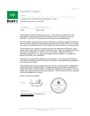
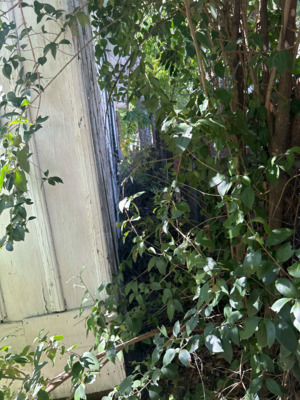
Page 1 of 1 Engineer’s Report SUBJECT: Foundation and framing performance and suitability for reuse 900 Spence Street, Austin, Texas 78702 JOB NUMBER: DATE OF SITE VISIT: 24045 May 1, 2024 At the request of builder Dominique Levesque, I visited the site to review the current performance of the building and to offer an opinion about its suitability for reuse in a renovation. This report is a summary of our discussion and my observations. Built in the 1960’s according to tax records, the house is a one-story bungalow style with a pier-and-beam foundation and wood-framed superstructure clad with siding. It is currently unoccupied and dilapidated. Most interior finishes have been removed to expose the studs. The foundations are a jumble of original cedar piers and replacement CMU piers of poor quality, which support 4x6 floor beams and 2x6 floor joists. Signs of damage from moisture and insects are widespread. The floor is not level, which is likely the result of soil movement and wood rot. The grade surrounding the house appears to be higher than grade in the middle of the crawlspace. The readily visible studs were generally in good condition. The ceiling and roof framing were mostly concealed by the wood ceiling, but through an opening the framing appeared to be 2x4 joists and rafters. The foundation piers must be replaced with piers built to current standards. Supplemental support in the form of additional piers and larger beams and joists may be necessary to support the weight of modern finishes. Crawlspace drainage must be corrected. All rotted beams, joists and studs must be found and replaced. The roof structure must be assessed and likely strengthened or replaced. Please call with any questions. SIGNED: Dennis Duffy, PE DISTRIBUTION: Dominique Levesque with Levesque & Co. Duffy Engineering, Inc. | 1402 Cuernavaca Drive N | Austin, Texas 78733 | phone: (512) 402-0074 | Texas Firm Registration No. F-8637 2300 Pasadena Dr St A Austin, TX 78757 office 512-452-2401 fax 512-452-3556 September 18, 2024 Dominique Levesque Levesque and Company RE: 900 Spence After inspecting the property for insect/rodent activity we found tons of damage to almost the whole house from Subterranean termites as well as rats. While we are not structural engineers my tech says the house does not feel safe to walk through. The termite damage is extraordinary. Massive amounts of termite damage to the front porch, the right side of the …
ZONING CHANGE REVIEW SHEET CASE NUMBER: PR-2024-026690; GF-2024-043975 HLC DATES: May 1, 2024; June 5, 2024; July 3,2024; August 7, 2024; September 4, 2024; October 2, 2024 PC DATES: November 12, 2024 APPLICANT: Historic Landmark Commission (owner-opposed) HISTORIC NAME: Romo-Johnson House WATERSHED: Lady Bird Lake ADDRESS OF PROPOSED ZONING CHANGE: 900 Spence Street ZONING CHANGE: SF-3-NP to SF-3-H-NP, East Cesar Chavez NP COUNCIL DISTRICT: 3 STAFF RECOMMENDATION: Grant historic zoning per the recommendation of the 2016 East Austin Historic Resource Survey. QUALIFICATIONS FOR LANDMARK DESIGNATION: The 2016 East Austin Historic Resource Survey recommends the building as meeting the criteria for architecture and historical associations. HISTORIC LANDMARK COMMISSION ACTION: June 5, 2024 – postpone the public hearing. July 3, 2024 – initiate historic zoning (9-0). September 4, 2024 – postpone the public hearing. October 2, 2024 – recommend historic zoning (10-0). PLANNING COMMISSION ACTION: CITY COUNCIL ACTION: CASE MANAGER: Kalan Contreras, 512-974-2727 NEIGHBORHOOD ORGANIZATIONS: Austin Independent School District, Austin Lost and Found Pets, Austin Neighborhoods Council, Del Valle Community Coalition, East Austin Conservancy, East Cesar Chavez Neighborhood Association, East Cesar Chavez Neighborhood Plan Contact Team, East Town Lake Citizens Neighborhood Association, El Concilio MexicanAmerican Neighborhoods, Friends of Austin Neighborhoods, Greater East Austin Neighborhood Association , Guadalupe Neighborhood Development Corporation, Homeless Neighborhood Association, Neighborhood Empowerment Foundation, Neighbors United for Progress, Preservation Austin, SELTexas, Sierra Club, Austin Regional Group, Tejano Town, Waterloo Greenway, Willow Spence Historic District Neighborhood Assn. DEPARTMENT COMMENTS: The 2016 East Austin Historic Resource Survey recommends the building as eligible for designation as a local landmark, contributing to a potential local historic district, and individually eligible for listing in the National Register of Historic Places. The survey notes that it is significant as an exemplar of Austin’s residential development at the start of the twentieth century, though the property does not appear to be associated with particular individuals, and that the house’s cumulative occupancy history is a good example of the overall settlement patterns of the district. BASIS FOR RECOMMENDATION: § 25-2-352(3)(c)(i) Architecture. The property embodies the distinguishing characteristics of a recognized architectural style, type, or method of construction; exemplifies technological innovation in design or construction; displays high artistic value in representing ethnic or folk art, architecture, or construction; represents a rare example of an architectural style in the city; serves as an outstanding example of the work of an architect, builder, or artisan who significantly contributed to the development …
MEMORANDUM TO: Chair and Members of the Planning Commission FROM: Sara Groff, Planning Department – Jurisdictional Matters DATE: November 5, 2024 RE: Proposed swap of approximately 13.8 acres from Austin’s extraterritorial jurisdiction (ETJ) with approximately 6.6 acres from Manor’s ETJ along Blue Bluff Road. The City of Manor, at the behest of the property owner, has requested the swap of approximately 13.8 acres of Austin’s ETJ with approximately 6.6 acres of Manor’s ETJ. The property in question is located along Blue Bluff Road at the intersection of Old HWY 20 and Blue Bluff Road in northeastern Travis County, outside Council District 1. Along with the request, the landowner has agreed to grant a conservation easement on the property leaving Austin’s ETJ. This request was distributed to the following staff: Planning, Watershed Protection Division, Austin Water, and Transportation for review. In accordance with the 2007 City Council adopted policy regarding ETJ adjustments, requests for ETJ release are typically reviewed by staff from several city departments and evaluated in terms of: • Annexation potential • Environmental impacts • • • Hardship or extenuating circumstances Impact on infrastructure investments Long-term effects of cumulative ETJ releases There is currently no request from the landowner for annexation into City of Austin’s Full Purpose Jurisdiction. Generally, Austin City Council looks for equivalent environmental protection to be provided on land released from the City’s jurisdiction. Staff from Watershed Protection have reviewed the proposed release and find it aggregable with the conversation easement. Austin Water is in the process of working with City of Manor and the PUC on a Water/Waterwater CCN transfer to align both City’s Water and Wastewater CCN boundaries along Blue Bluff Road to match what will be the new ETJ boundaries. Austin Water supports the ETJ swap. 1 Finally, agreeing to the ETJ swap would not negatively impact any existing or planned City investments in roadway infrastructure. The area is not served by City-maintained roads. Staff recommends the ETJ swap with the City of Manor in the interest of cleaner boundaries and regional cooperation with neighboring jurisdictions. City Council consideration of this request is tentatively scheduled for December 12, 2024. Attachments: A. Map of proposed release area B. Approved Manor City Council resolution 2023-45 officially requesting ETJ swap C. Proposed Conservation Easement D. ETJ Release Policy Evaluation 2 MANOR FULL PURPOSE From Manor to Austin Old HWY 20 AUSTIN 2 MILE ETJ d e …
To: From: Chair Hempel Vice Chair Azhar Planning Commission Members Brent Lloyd Development Officer Development Services Department Date: October 18, 2024 Subject: Case No. C20-2023-045 |Response to Questions re: Infill Plats & Site Plan Lite, Pt. 2 To assist the Planning Commission in considering the above-referenced item, this memo provides staff responses to questions sent to us by a commissioner earlier this week. (Each question, quoted from the commissioner’s email, is followed by a staff response.) An interdepartmental staff team will be available to address additional questions at the Planning Commission’s October 22, 2024 meeting. “You mentioned previously, the current draft language is a result of ‘a lot of input Question 1. and discussion from stakeholders that have occurred over the last several months.’ Please let me know which stakeholders have agreed to this draft, specifically which environmental groups or any specifically focused on flood controls?” Response: of the proposal. In general: Staff cannot speak to which stakeholder groups support or oppose the latest version Stakeholders associated with environmental groups have expressed concerns regarding flooding impacts, particularly with respect to the “Site Plan Lite” portion of the proposal. Staff from the Watershed Protect Department have addressed these concerns on several occasions, including at two stakeholder engagement sessions, two Environmental Commission meetings, and a meeting of the Housing & Planning Committee. Stakeholders associated with the infill development community have expressed concerns that the proposal does not sufficiently relax regulations. While differences remain, staff has made numerous changes to address practical concerns raised by these stakeholders. As discussed in the staff report, these changes will help to increase flexibility and reduce costs for residential infill projects while maintaining existing floodplain and water quality protections. “In your previous presentation, you cite this proposal will streamline the Question 2. development process for approximately 3,500 sites. Is that the total universe of which properties could utilize this streamlined process? Or an estimated number who DSD believes will use the streamlined process?” Under the Site Plan Lite (“SP-Lite”) proposal, no engineered drainage analysis or Response: onsite detention facilities would be required for 5-16 projects if: (1) the site is no greater than 0.50 acres; and (2) the applicant provides a topographic drainage plan demonstrating that water flows naturally to the street or storm drain system. Providing engineered drainage analysis and onsite detention facilities can account for at least 30-40% of total costs, so projects that meet …
C20-2024-039 Bollard Installation For Medical Facilities Danielle Morin | CIP Manager | November 12, 2024 Presentation Overview • Background • Council Resolution • Code Amendment • Criteria/Rule • Schedule • Questions/Answers 11/7/2024 2 City Council Resolution 20240718-092 BE IT RESOLVED BY THE CITY COUNCIL OF THE CITY OF AUSTIN: City Council initiates amendments to City Code, including Title 25 (Land Development), to require the installation of crash-rated bollards or other similar safety barriers to prevent vehicle-into-building crashes at the pedestrian entrances of medical facilities with nearby vehicular traffic. City Council Resolution 20240718-092 “BE IT FURTHER RESOLVED: When proposing amendments initiated by this Resolution, the City Manager is directed to explore: 1. the feasibility of requiring safety barriers in public right-of-way areas adjacent to medical facilities to enhance pedestrian safety and prevent vehicle crashes; 2. whether permit applications to expand, remodel, or upgrade existing facilities can trigger this requirement to install safety bollards; incentives for existing facilities to voluntarily comply with new City requirements to install bollards; 3. 4. 5. recommendations for the City's state and federal legislative agenda; and any other necessary changes that achieve the objectives of this resolution. BE IT FURTHER RESOLVED: The City Manager is directed to engage with stakeholders, including medical facility operators, with the goal of bringing about compliance with any new requirements City Council adopts.” Changes to Title 25 LDC Chapter 25-6, Transportation Modify LDC 25-6-1 (Definitions) (7) MEDICAL FACILITY means a building or structure where the primary purpose is for: (a) hospital services (general); (b) hospital services (limited); or (c) medical offices, if the building or structure is a walk-in clinic being used for the consultation, diagnosis, therapeutic, preventative, or medical care for minor illnesses and injuries. (9) PEDESTRIAN ENTRANCE means a functional entrance or door that is publicly accessible and designed for pedestrian use. Changes to Title 25 Create a new Section in 25-6 (Transportation) 25-6-324 PEDESTRIAN SAFETY BARRIERS FOR MEDICAL FACILITIES (A) This section applies to a development application for new construction of a medical facility. (B) An applicant is required to install security bollards in front of each pedestrian entrance to a medical facility in accordance with the Transportation Criteria Manual. (C) The installation of security bollards cannot obstruct accessible routes or accessible means of ingress and egress to the pedestrian entrance. (D) The director may waive this requirement if the applicant demonstrates the walkway to the pedestrian entrance is …
Case Number: C20-2024-021 ORDINANCE AMENDMENT REVIEW SHEET Amendment: C20-2024-021 Safety Bollards Description: Amend City Code Title 25 to require the installation of crash-rated bollards or other similar safety barriers to prevent vehicle-into-building crashes at the pedestrian entrances of medical facilities with nearby vehicular traffic. Background: Initiated by City Council Resolution No. 20240718-092. On July 18, 2024, City Council approved Resolution No. 20240718-092, to require the installation of crash-rated bollards or other similar safety barriers to prevent vehicle-into- building crashes at the pedestrian entrances of medical facilities with nearby vehicular traffic. The resolution directed staff to explore: the feasibility of requiring safety barriers in public right-of-way areas adjacent to medical facilities to enhance pedestrian safety and prevent vehicle crashes; whether permit applications to expand, remodel, or upgrade existing facilities can trigger this requirement; incentives for existing facilities to voluntarily comply; recommendations for the City's state and federal legislative agenda; and any other necessary changes that achieve the objectives of this resolution. Staff was also directed to engage with stakeholders, including medical facility operators, with the goal of bringing about compliance with any new requirements City Council adopts. Summary of Proposed Code Amendment: The proposed code amendment will: Amend City Code 25-6-1 (Definitions) to add new definitions for “medical facility” and “pedestrian entrance” and to renumber the remaining uses accordingly: 7) Medical Facility means a building or structure where the primary purpose is for: (a) hospital services (general); or (b) hospital services (limited); or (c) medical offices, if the building or structure is a walk-in clinic being used for the consultation, diagnosis, therapeutic, preventative, or medical care for minor illnesses and injuries; and (9) Pedestrian Entrance means a functional entrance or door that is publicly accessible and designed for pedestrian use. Create a new section of City Code (25-6-324 Pedestrian Safety Barrier for Medical Facilities) to describe requirements that apply to the new definitions, including that the code: • Applies to all new construction of pedestrian entrances on construction that meets the definition of a medical facility. 1 Case Number: C20-2024-021 • Refers applicants to technical guidance in Transportation Criteria Manual, to be posted in a subsequent rule. • Allows for alternative compliance if designed in a manner that mitigates the risk of vehicular crashes into the pedestrian entrance. Proposed Text Amendment(s): See attached draft ordinance. Staff Recommendation: Recommended Staff recommends the proposed Pedestrian Safety Barrier for Medical Facilities language for inclusion …
Colorado River Protections Ordinance P l a n n i n g C o m m i s s i o n N o v e m b e r 1 2 , 2 0 2 4 C I T Y O F A U S T I N W A T E R S H E D P R O T E C T I O N D E P A R T M E N T Presentation Outline Background • Summary Video • Council Resolution and Goals • Colorado River Overview • Erosion & Water Quality Threats and Costs to the Community Draft Ordinance • Draft Proposal & Analysis • Schedule Discussion C I T Y O F A U S T I N W A T E R S H E D P R O T E C T I O N D E P A R T M E N T 2 2-Minute Summary Video C I T Y O F A U S T I N W A T E R S H E D P R O T E C T I O N D E P A R T M E N T 3 Ordinance Youtube video link Council Resolution Community members asked Council to strengthen Colorado River protections; Council thereafter included in their June 2022 Council resolution: “… evaluate the effectiveness of existing Critical Water Quality Zone and Erosion Hazard Zone buffers on the Colorado River downstream of the Longhorn Dam and to propose protections that will provide adequate protections to the river that will ensure a healthy riparian corridor to stabilize the riverbank and protect property from erosion” C I T Y O F A U S T I N W A T E R S H E D P R O T E C T I O N D E P A R T M E N T 4 East Austin Longhorn Dam J. Trevino Metro Park Lady Bird Lake Roy Guerrero Park “Dog’s Head” Austin’s Colony Hornsby Bend Biosolids Plant Tesla SHEC/SAR WWTP Southeast Austin Parcel Count Acres Juris- diction Type CWQZ Buffer Acres 400ft Buffer Acres Acres 400ft minus CWQZ FULL ETJ Totals FULL ETJ Totals 241 243 484 50% 50% 100% 1,054 14,896 15,950 7% 93% 100% 281 1,929 2,211 13% 87% 100% 391 2,184 2,575 15% 85% 100% 109 255 ABIA 364 30% …
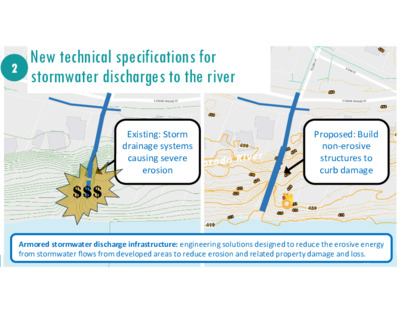
2 New technical specifications for stormwater discharges to the river Existing: Storm drainage systems causing severe erosion $$$ Proposed: Build non-erosive structures to curb damage Armored stormwater discharge infrastructure: engineering solutions designed to reduce the erosive energy from stormwater flows from developed areas to reduce erosion and related property damage and loss. 38 C I T Y O F A U S T I N W A T E R S H E D P R O T E C T I O N D E P A R T M E N T C o l o r a d o R i v e r C o l o r a d o R i v e r Proposal: Non-Erosive Stormwater Discharges 2 New technical criteria and specifications for outfalls to river 40ft. 66" pipe C I T Y O F A U S T I N W A T E R S H E D P R O T E C T I O N D E P A R T M E N T 39 Tillery Street Storm Drain Outfall Repair Example Drop Structure for Outfall Water from surface runoff Non-erosive passage to river Armoring Col. River C I T Y O F A U S T I N W A T E R S H E D P R O T E C T I O N D E P A R T M E N T 40 Water from storm drainage system Energy of flowing and falling water entirely contained within structure Tillery St. Outfall Structure Diagram Austin’s Colony Phase 2: No Stable Channel 41 Austin’s Colony Phase 4: Stable Channel 42 Austin’s Colony Phase 4: Stable Channel 43 3 400ft Critical Water Quality Zone (CWQZ) buffer Existing: CWQZ buffer width varies from 200 to 400ft L a d y B i r d L a k e Critical Water Quality Zones: Regulatory buffers to reduce the intensity of new development directly adjacent to waterways to protect natural riparian soils and vegetation that protect water quality and flows; low-intensity uses are permitted; high-intensity uses are restricted. P u r p l e a r e a s s h o w 1 0 0 - y e a r f l o o d p l a i n s C I T Y O F A U S T I N W A …
10/30/24 C20-2022-0025 ORDINANCE AMENDMENT REVIEW SHEET Amendment: C20-2022-0025, Land Development Code Amendment to Title 25-7 Drainage Description: Consider an ordinance regarding amendments to Title 25 related to adequate protections to the Colorado River downstream of the Longhorn Dam. Proposed Language: To revise 25-7-32(B)(2) to establish the erosion hazard zone of the Colorado River downstream of the Longhorn Dam as 200 feet from the ordinary high-water mark, with exceptions for trails and bounded by public rights-of-way and only affecting new habitable structures and subsurface infrastructure. See Attachment A. Summary of proposed code changes: The proposed code change would expand the Erosion Hazard Zone (EHZ) associated with the Colorado River downstream of the Longhorn Dam to 200 feet from the ordinary high-water mark (federally defined river bank). The existing EHZ is measured 100 feet from the ordinary high-water mark. The EHZ would only apply to new habitable structures (e.g., residential houses) and infrastructure (e.g., new roadways, water and wastewater pipes) and NOT to existing structures and infrastructure or to new sheds, pools, patios, decks, fences, and the like. Staff are proposing that EHZ requirements for hard-surfaced trails remain at 100 feet. The EHZ would also not extend past existing public rights-of-way. Thus, for example, a property on the far side of a public roadway from river would not be subject to the EHZ. Additionally, single-family residential construction in the Extra Territorial Jurisdiction would not be affected by this ordinance since Travis County, not the City of Austin, regulates such construction. Background: This ordinance responds to Council Resolution No. 20220609-061, which initiated Land Development Code amendments related to environmental, drainage, and landscape requirements. A previous ordinance addressed many of the elements of this resolution, but certain proposed changes were not adopted at the time so that staff could conduct additional analyses and community outreach. The proposed ordinance addresses direction to staff to “evaluate the effectiveness of the existing Critical Water Quality Zone and Erosion Hazard Zone buffers on the Colorado River downstream of the Longhorn dam and to propose protections that will provide adequate protections to the river that will ensure a healthy riparian corridor to stabilize the riverbank and protect property from erosion.” Board and Commission Actions: October 16, 2024: Codes and Ordinances Joint Committee supported the staff recommendation on a vote of 6-0 with the following two amendments: 1. Recommend staff create a map for public consumption before October 28th. 2. …
SUBDIVISION REVIEW SHEET CASE NO.: C8S-64-038(VAC) COMMISSION DATE: November 12, 2024 SUBDIVISION NAME: Walnut Plat Vacation (Total Plat Vacation) ADDRESS: 3212 Walnut Avenue APPLICANT: Jessica Braun (Garden Villas Roots LP) AGENT: Maximiliano Martinez (Milian Consulting & Engineering) ZONING: SF-3-NP (single family residence) NEIGHBORHOOD PLAN: Upper Boggy Creek AREA: 0.382 acres (16,645 sf) LOTS: 1 COUNTY: Travis DISTRICT: 9 WATERSHED: Boggy Creek JURISDICTION: Full Purpose VARIANCE: N/A DEPARTMENT COMMENTS: The request is for the approval of the Lundell Addition total plat vacation. The applicant proposes to vacate the Lundell Addition (Travis County Vol 75, Page 165) that created 1 lot to return back to the 2 lots in the underlying plats: Dahlstrom and Cook Subdivision Lot 1 (Travis County Vol 19, Page 69) and Forest Hills ‘D’ Lot 14 (Travis County Vol 6, Page 26). STAFF RECOMMENDATION: Staff recommends approval of this total plat vacation. The vacation of the subdivision meets applicable State and City of Austin Land Development Code requirements. CASE MANAGER: Tiffany Turpen PHONE: 512-978-4654 E-mail: tiffany.turpen@austintexas.gov ATTACHMENTS Exhibit A: Vicinity map Exhibit B: Lundell Addition, Travis County Vol 75, Page 165 (plat to be vacated) Exhibit C: Dahlstrom and Cook Subdivision, Travis County Vol 19, Page 69 Exhibit D: Forest Hills ‘D’, Travis County Vol 6, Page 26 Exhibit E: Electric Utility Distribution Easement (2024098154) Exhibit F: Plat vacation document Property Profile Location Map Legend Appraisal Districts TCAD Parcels Jurisdictions Fill Jurisdiction FULL PURPOSE 0 150 300 ft 10/10/2024 This product is for informational purposes and may not have been prepared for or be suitable for legal, engineering, or surveying purposes. It does not represent an on-the-ground survey. This product has been produced by the City of Austin for the sole purpose of geographic reference. No warranty is made by the City of Austin regarding specific accuracy or completeness. Notes
PLANNING COMMISSION REGULAR MEETING MINUTES TUESDAY, OCTOBER 22, 2024 The Planning Commission convened in a regular meeting on Tuesday, October 22, 2024, at Austin City Hall, Council Chambers, Room 1001, 301 W. Second Street, in Austin, Texas. Chair Hempel called the Planning Commission meeting to order at 6:06 p.m. Board Members/Commissioners in Attendance: Claire Hempel Greg Anderson Nadia Barrera-Ramirez Casey Haney Adam Haynes Felicity Maxwell Alberta Phillips Danielle Skidmore Alice Woods Board Members/Commissioners in Attendance Remotely: Awais Azhar Grayson Cox Patrick Howard Ryan Johnson Danielle Skidmore Board Members/Commissioners absent: PUBLIC COMMUNICATION: GENERAL Angela Garza, DB90 Bobby Levinski, Hays Commons 1 APPROVAL OF MINUTES Approve the minutes of the Planning Commission regular meeting on October 8, 2024. The minutes from the meeting of October 8, 2024, were approved on the consent agenda on Commissioner Woods’ motion, Commissioner Maxwell’s second, on a 13-0 vote. PUBLIC HEARINGS Location: 2. Plan Amendment: NPA-2024-0027.01 - Rawson Saunders - Tarrytown Christian Church Improvements; District 10 2614 and 2614 ½ Exposition Boulevard, 2702 McCoullugh Street, 2615 ½ and 2611 Hillview Road, Taylor Slough South Watershed; Central West Austin Combined (West Austin) Neighborhood Planning Area Owner/Applicant: Austin Area School For Dyslexics Inc./Tarrytown Baptist Church Agent: Request: Staff Rec.: Staff: Thrower Design, LLC (Ron Thrower & Victoria Haase) Single Family to Mixed Use/Office land use Applicant postponement request to December 17, 2024 Maureen Meredith, 512-974-2695, maureen.meredith@austintexas.gov Planning Department The motion to approve the Applicant’s postponement request to December 17, 2024, was approved on the consent agenda on Commissioner Woods’ motion, Commissioner Maxwell’s second, on a 13-0 vote. 3. Rezoning: Location: C14-2024-0051 - Rawson Saunders - Tarrytown Christian Church Improvements; District 10 2614 and 2614 ½ Exposition Boulevard, 2702 McCoullugh Street, 2615 ½ and 2611 Hillview Road, Taylor Slough South Watershed; Central West Austin Combined (West Austin) Neighborhood Planning Area Owner/Applicant: Austin Area School For Dyslexics Inc./Tarrytown Baptist Church Agent: Request: Staff Rec.: Staff: Thrower Design, LLC (Ron Thrower & Victoria Haase) SF-3-NP to GO-MU-NP Applicant postponement request to December 17, 2024 Cynthia Hadri, 512-974-7620, cynthia.hadri@austintexas.gov Planning Department The motion to approve the Applicant’s postponement request to December 17, 2024, was approved on the consent agenda on Commissioner Woods’ motion, Commissioner Maxwell’s second, on a 13-0 vote. 1. 2 4. Plan Amendment: NPA-2023-0017.01 - Anderson Square, District 4 Location: 910, 912, 914 & 916, 1012 & 1012 ½, 1100, 1100 ½ & 1102 ½ W. Anderson Lane, 7905 ½, 8003, …
Meredith, Maureen To: Cc: Subject: EMLKCT Chair; Howard, Patrick - BC; Hempel, Claire - BC; Haynes, Adam - BC; Cox, Grayson - BC; Ramirez, Nadia - BC; Cohen, Jessica - BC; Maxwell, Felicity - BC; Phillips, Alberta - BC; Anderson, Greg - BC; Woods, Alice - BC; Haney, Casey - BC; Skidmore, Danielle - BC; Johnson, Ryan - BC; Azhar, Awais - BC; Hunter, Candace - BC; Tomko, Jonathan Lawler, John; Brown, Destiny; Mays, Sharon; Ms. Angela Benavides Garza; Dianna Holman; Byrd, Eric RE: 1143 & 1145 Gunter Street & Abbate Cir Rezoning - PC Nov 12 From: EMLKCT Chair < Sent: Monday, November 11, 2024 9:17 PM To: Howard, Patrick - BC <BC-Patrick.Howard@austintexas.gov>; Hempel, Claire - BC <BC- Claire.Hempel@austintexas.gov>; Haynes, Adam - BC <BC-Adam.Haynes@austintexas.gov>; Cox, Grayson - BC <BC- Grayson.Cox@austintexas.gov>; Ramirez, Nadia - BC <BC-Nadia.Ramirez@austintexas.gov>; Cohen, Jessica - BC <BC- Jessica.Cohen@austintexas.gov>; Maxwell, Felicity - BC <BC-Felicity.Maxwell@austintexas.gov>; Phillips, Alberta - BC <BC-Alberta.Phillips@austintexas.gov>; Anderson, Greg - BC <bc-Greg.Anderson@austintexas.gov>; Woods, Alice - BC <BC-Alice.Woods@austintexas.gov>; Haney, Casey - BC <BC-Casey.Haney@austintexas.gov>; Skidmore, Danielle - BC <BC-Danielle.Skidmore@austintexas.gov>; Johnson, Ryan - BC <BC-Ryan.Johnson@austintexas.gov>; Azhar, Awais - BC <BC-Awais.Azhar@austintexas.gov>; Hunter, Candace - BC <BC-Candace.Hunter@austintexas.gov>; Meredith, Maureen <Maureen.Meredith@austintexas.gov>; Tomko, Jonathan <Jonathan.Tomko@austintexas.gov> Cc: Lawler, John <John.Lawler@austintexas.gov>; Brown, Destiny <destiny.brown@austintexas.gov>; Mays, Sharon <Sharon.Mays@austintexas.gov>; Ms. Angela Benavides Garza < >; Dianna Holman < >; Byrd, Eric <eric.byrd@austintexas.gov> Subject: 1143 & 1145 Gunter Street & Abbate Cir Rezoning - PC Nov 12 External Email - Exercise Caution Hello Commissioner Howard, Planning Commissioners, District 1 City Council team and City Staff, The EMLK Contact team Co-Chairs has participated in several applicant and neighbor meetings to understand the Gunter & Abbate Cir rezoning project. This message is in regards to items 4 & 5 on the Nov 12 Planning Commission meeting, case numbers NPA-2024-0015.01 and C14-2024-0109. We understand the neighbors concerns to be as follows, and we have observed the following steps they've taken in the last couple of months to facilitate input from their fellow neighbors: The density of the project as proposed by the developer (MF3) is a safety risk for drivers or cyclists travelling down Gunter St, a small road between two larger arteries, Oak Springs and Springdale, which already gets significant traffic. The road is full already with parking on both sides, and only one lane of car or bike traffic gets through. Infrastructure, including water pressure and fire safety/access to emergency vehicles, would be stressed beyond capacity or …
ZONING CHANGE REVIEW SHEET CASE: C14-2024-0109 (Gunter Street Rezoning) DISTRICT: 1 ADDRESS: 1143 ¾ Gunter Street, 1145 Gunter Street, 1145 ½ Gunter Street, 3605 Abbate Circle, and 1144 Wayneroy Drive ZONING FROM: SF-3-NP TO: MF-3-NP and SF-6-NP on 3605 Abbate Circle (as amended) SITE AREA: approximately 2.7462 acres (approximately 119,624 square feet) PROPERTY OWNER: RCG Gunter LLC and REAL Holdings LLC AGENT: Husch Blackwell LLP (Nikelle Meade) CASE MANAGER: Jonathan Tomko (512) 974-1057, jonathan.tomko@austintexas.gov STAFF RECOMMEDATION: Staff does not recommend granting multifamily residence (medium density)- neighborhood plan (MF-3-NP) combining district zoning and offers the alternative recommendation of multifamily residence (medium density)-conditional overlay- neighborhood plan (MF-3-CO-NP) combining district zoning on the entire site except for 3605 Abbate Circle. The conditional overlay would prohibit more than 50 dwelling units. Staff recommends granting townhouse & condominium residence-neighborhood plan (SF-6-NP) combining district zoning on 3605 Abbate Circle. For a summary of the basis of Staff’s recommendation, please see the basis of recommendation section below. PLANNING COMMISSION ACTION / RECOMMENDATION: October 22, 2024: Applicant & Neighborhood joint postponement request to November 12, 2024 November 12, 2024: Case is scheduled to be heard by Planning Commission CITY COUNCIL ACTION: TBD ORDINANCE NUMBER: N/A ISSUES: N/A CASE MANAGER COMMENTS: The property in question is currently approximately seven single family homes constructed in the early 1940s and 1950s. The tract is approximately 550 feet east of Airport Boulevard, approximately 550 feet south of Oak Springs Drive, approximately 600 feet west of Springdale C14-2024-0109 2 Road, and approximately 800 feet north of the intersection of Airport Boulevard and Gunter Street. Airport Boulevard is an ASMP level 3 roadway, an Imagine Austin Activity Corridor and a part of the transit priority network. Springdale Road is an ASMP level 2 roadway, an Imagine Austin Activity Corridor and a part of the transit priority network. Oak Springs Drive is an ASMP level 2 roadway, and a part of the transit priority network. The tract is approximately 550 feet north of the Springdale Station Imagine Austin Activity Center. Sidewalks exist along the length of Gunter Street and Munson Street, sidewalks and recently upgraded bicycle infrastructure exists along Oak Springs Drive and Springdale Road. Two high frequency bus routes (every 15-30 minutes) are proximate to the site: Route 2 Rosewood/Cesar Chavez and Route 300 Springdale/Oltorf. Both routes have stops within ¼ mile of the subject tract. Route 135 Dell Limited and 350 Airport Boulevard …
Eric Hansen 1301 W 49th Street Aus-n, TX 78756 773-294-7705 Ehansen@ November 11, 2024 Case Number: NPA-2024-0018.04 Contact: Maureen Meredith Public Hearing: Nov 12, 2024 - Planning Commission Dear Planning Commission, I am agreeing with the leMer provided by Jay Long of 1211 w 49th Street 78756. His leMer was so eloquently wriMen, I have just copied it here. I formally protest the future land use designa9on change proposed for 1200 W 49th Street from Mixed Use/Office to Mixed Use. We have been no9fied that the property owner of this address believes that an upgraded future land use designa9on status would increase their pool of poten9al renters, as they were having trouble leasing their property. As of this wri9ng, every office building on W 49th Street and the adjacent streets, are leased and fully occupied, including as of this week, the property in ques9on. 1200 W 49th street is now leased by Overland Architecture, an appropriate and welcome use in our neighborhood. Myself and my neighbors who have owned and resided in single family proper9es on W 49th street, most for over twenty years don’t see a need for this type of change to improve the rentability of any of these proper9es, if they are already fully rented under the current land use designa9on. It is our conten9on that the current land use reflects the need for compa9bility with the other exis9ng residen9al and office uses in our neighborhood and community. It is our sincere request that you deny this requested land use designa9on. Sincerely yours, Eric Hansen
Jay Long 1211 W 49th Street Austin, TX 78756 (512) 626-1149 November 8, 2024 Case Number: NPA-2024-0018.04 Contact: Maureen Meredith Public Hearing: Nov 12, 2024 - Planning Commission Dear Planning Commission, I am writing this letter on behalf of myself and my residential neighbors to formally protest the future land use designation change proposed for 1200 W 49th Street from Mixed Use/Office to Mixed Use. We have been notified that the property owner of this address believes that an upgraded future land use designation status would increase their pool of potential renters, as they were having trouble leasing their property. As of this writing, every office building on W 49th Street and the adjacent streets, are leased and fully occupied, including as of this week, the property in question. 1200 W 49th street is now leased by Overland Architecture, an appropriate and welcome use in our neighborhood. Myself and my neighbors who have owned and resided in single family properties on W 49th street, most for over twenty years don’t see a need for this type of change to improve the rentability of any of these properties, if they are already fully rented under the current land use designation. It is our contention that the current land use reflects the need for compatibility with the other existing residential and office uses in our neighborhood and community. It is our sincere request that you deny this requested land use designation. Sincerely yours, Jay Long
Eric Hansen 1301 W 49th Street Aus-n, TX 78756 773-294-7705 Ehansen@idealproduc9ons.com November 11, 2024 Case Number: NPA-2024-0018.04 Contact: Marcelle Boudreaux Public Hearing: Nov 12, 2024 - Planning Commission Sincerely yours, Eric Hansen Dear Planning Commission, I am agreeing with the leOer provided by Jay Long of 1211 w 49th Street 78756. His leOer about rezoning the proposed property was so eloquently wriOen, I have just copied it here. I am writing this letter on behalf of myself and my residential neighbors to formally protest the zoning change proposed for 1200 W 49th Street from LO-MU-ETOD-DBETODNP to GR-MU-ETOD- DBETOD-NP. We have been notified that the property owner of this address believes that an upgraded zoning status would increase their pool of potential renters, as they were having trouble leasing their property. As of this writing, every oQice building on W 49th Street and the adjacent streets are leased and fully occupied, including as of this week, the property in question. 1200 W 49th street is now leased by Overland Architecture, an appropriate and welcome use in our neighborhood. Myself and my neighbors who have owned and resided in single family properties on W 49th street, most for over twenty years don’t see a need for this type of change to improve the rentability of any of these properties, if they are already fully rented under the current zoning. It is our contention that the current zoning is appropriate and reflects the need for compatibility with the current existing residential and oQice uses in our neighborhood and community. It is our sincere request that you deny this requested zoning change. Sincerely yours,.
ZONING CHANGE REVIEW SHEET DISTRICT: 7 CASE: C14-2024-0116– 1200 W 49th St ADDRESS: 1200 West 49th Street ZONING FROM: LO-MU-ETOD-DBETOD-NP TO: GR-MU-ETOD-DBETOD-NP SITE AREA: 0.33 acres PROPERTY OWNER: Grover Office Partners LLC (Michael Polombo) AGENT: HD Brown Consulting LLC (Amanda Brown) CASE MANAGER: Marcelle Boudreaux (512-974-8094, marcelle.boudreaux@austintexas.gov) STAFF RECOMMENDATION: The Staff recommendation is to grant community commercial- mixed use- equitable transit-oriented development- density bonus ETOD- neighborhood plan (GR-MU- ETOD-DBETOD-NP) combining district zoning. PLANNING COMMISSION ACTION / RECOMMENDATION: November 12, 2024: CITY COUNCIL: ORDINANCE NUMBER: ISSUES: In 2024, the City created a transit-supportive overlay district intended to support the Project Connect Phase 1 Austin Light Rail project. Properties within half-mile of the Phase 1 Austin Light Rail alignment and Priority Extensions were included within this overlay, and certain properties were rezoned through a City-initiated process to include the ETOD and DBETOD combining districts. Further, properties rezoned with DBETOD combining district were categorized into Subdistrict 1 (maximum allowable height of 120 feet when complying with affordable housing requirements) or Subdistrict 2 (maximum allowable height of 90 feet when complying with affordable housing requirements), generally based on property distance of ¼-mile or ½-mile from the Phase 1 alignment, respectively. C14-2024-0116 Page 2 This subject site was included in that City-initiated rezoning to add the combining districts and to assign location within Subdistrict 2, effective in July 2024. However, that rezoning process did not modify any base district zoning, which is the subject of this request. No Conditional Overlay has been recommended for the site due to the ETOD overlay use prohibitions and conditional uses. Although allowed in the GR base zoning district, these uses are prohibited within the ETOD overlay: Automotive Rentals; Automotive Repair Services; Automotive Sales; Drop Off Recycling Collection Facility; Exterminating Services; Funeral Services; Research Services; and Service Station. Although allowed in the GR base zoning district, these uses are conditional within the ETOD overlay: Automotive Washing of any type; Bail Bond Services; Commercial Off-Street Parking; Communications Services; Off-Site Accessory Parking; Pawn Shop Services; Pedicab Storage and Dispatch; and Special Use Historic. On September 16, 2024, City of Austin staff sponsored a virtual community meeting to provide an opportunity for the neighborhood plan contact team, nearby residents, property owners, and any other interested parties to discuss the proposed development and the neighborhood plan amendment request. CASE MANAGER COMMENTS: The subject rezoning area is approximately 0.33 acres, located at the corner of …
MEMORAN DUM From: To: CC: Date: Subject: Austin Jones, P.E. Kelly Rees, P.E. Renee Johns, AICP; Ramin Komeili, P.E. September 18, 2024 Stonehollow Multifamily – Zoning Transportation Analysis Fina Memo (C14-2024- 0125, C14-2024-0126) The Transportation & Public Works Department (TPW) has reviewed the September 12th, 2024, “Stonehollow Multifamily Zoning Transportation Analysis”, prepared by Kimley-Horn. The proposal is for a new mid-rise multifamily development consisting of 1,585 dwelling units. The site is located south of Gracy Farms Ln and west of Metric Blvd in the City of Austin, Texas. The site will have access to the surrounding roadway network via three driveways on Gracy Farms Ln and eight driveways on Stonehollow Dr. The proposed driveways will be situated at the same location as the existing driveways that are currently in use for accessing the existing development. The development is anticipated to be constructed in one phase to be completed in 2027. Figure 1. Site Location Page 1 of 3 Roadways Gracy Farm Lane The ASMP classifies Gracy Farm Ln. as 4 travel lanes with a raised median (Level 3) roadway in the vicinity of the site. According to TxDOT average daily traffic counts, the 2020 ADT was approximately 4,922 vehicles per day (vpd). The posted speed limit is 35 mph. ASMP recommends improvements to include constructing additional travel lanes, raised medians, and all ages and abilities bicycle facilities. ROW dedication may be required from new development and commercial redevelopment through the land development process. Required ROW does not apply to single- family home properties. Stonehollow Dr The ASMP classifies Stonehollow Dr. as 4 travel lanes with a raised median (Level 3) roadway in the vicinity of the site. The posted speed limit is 35 mph. ASMP recommends improvements that include adding a raised median, consolidating driveways, and all ages and abilities bicycle facilities. ROW dedication may be required from new development and commercial redevelopment through the land development process. Required ROW does not apply to single-family home properties. Trip Generation and Traffic Analysis The project assumes 1,585 high-rise multi-family dwelling units (ITE Code 222). Based on the Institute of Transportation Engineer’s Trip Generation Manual, 11th Edition, the proposed development will generate 7,196 vehicle trips per day. See Table 1 for a detailed breakdown of the trip generation. Table 1. Trip Generation Land Use Size 222 - Multifamily Housing (Mid Rise) 1,585 Dwelling Units Total Unadjusted Trips Existing Trips TDM Trips (10% …
To Whom It May Concern: My wife & I, along with our two children, own and occupy a single-family home at 6103 Cherrylawn Circle. I have reviewed zoning application C14-2024-0122 and Neighborhood Plan Amendment #NPA-2024-0015.03 to rezone the properties at addresses 6102, 6106, and 6108 on Cherrylawn Circle. I am writing this letter to express extreme concern from not only my family, but from many families that live on the street and in the surrounding area. Please consider this letter a formal protest of the changes being proposed by Emerson Smith (the “Applicant”). The Applicant states in the application letter that this plan would “support the vision of the [neighborhood] plan.” The Applicant goes on to state a number of proposed benefits to the community while ignoring the obvious detriments and disadvantages to the long-standing residents of the area. For example, 1) the proposed rezoning is a quiet, residential street with kids and families that have lived there for many years; 2) the streets into and out of the area of the proposed rezoning are not built to handle commercial traffic; 3) there is no available parking for the proposed offices other than street parking that would disrupt the residents; 4) there are no support amenities within walking distance such as restaurants, coffee shops, etc. that are necessary to support an office; and 5) the implications of this rezoning allow the Applicants or future owners to tear down single-family homes at great cost to the residents and neighborhood in order to build office & commercial buildings on a residential street. The proposed zoning also goes against the zoning principles in Section II of the Austin Zoning Guide (https://www.austintexas.gov/sites/default/files/files/Planning/zoning_guide.pdf). This creates a multitude of violations against the zoning principles including, but not limited to, 1) “Zoning should satisfy a public need and not constitute a grant of special privilege to an individual owner; the request should not result in spot zoning.”; 2) “Granting a request for zoning should result in an equal treatment of similarly situated properties.”; and 3) “Zoning should allow for a reasonable use of the property.” The proposed changes do not meet any of these guidelines. In addition to the above, office vacancy rates are at an all-time high in Austin (>25%), so it is unclear why the Applicant’s companies now need office space in a residential area that has no amenities to support those offices. This will …
************************************************************************ MEMORANDUM TO: Planning Commission Members FROM: Sara Groff Planning Department DATE: November 8, 2024 RE: CETJ-2024-0001 - Manor Downs ETJ Release Withdrawal Memo *********************************************************************** * applicant would The withdrawn from P l e a s e s e e a t t a c h e d r e q u e s t f r o m t h e a p p l i c a n t . request like to the November 12, 2024 Planning Commission Agenda. case CETJ-2024-0001 be MEMORANDUM TO: Chair and Members of the Planning Commission FROM: Sara Groff, Planning Department – Jurisdictional Matters DATE: November 5, 2024 RE: Proposed swap of approximately 13.8 acres from Austin’s extraterritorial jurisdiction (ETJ) with approximately 6.6 acres from Manor’s ETJ along Blue Bluff Road. The City of Manor, at the behest of the property owner, has requested the swap of approximately 13.8 acres of Austin’s ETJ with approximately 6.6 acres of Manor’s ETJ. The property in question is located along Blue Bluff Road at the intersection of Old HWY 20 and Blue Bluff Road in northeastern Travis County, outside Council District 1. Along with the request, the landowner has agreed to grant a conservation easement on the property leaving Austin’s ETJ. This request was distributed to the following staff: Planning, Watershed Protection Division, Austin Water, and Transportation for review. In accordance with the 2007 City Council adopted policy regarding ETJ adjustments, requests for ETJ release are typically reviewed by staff from several city departments and evaluated in terms of: • Annexation potential • Environmental impacts • • • Hardship or extenuating circumstances Impact on infrastructure investments Long-term effects of cumulative ETJ releases There is currently no request from the landowner for annexation into City of Austin’s Full Purpose Jurisdiction. Generally, Austin City Council looks for equivalent environmental protection to be provided on land released from the City’s jurisdiction. Staff from Watershed Protection have reviewed the proposed release and find it aggregable with the conversation easement. Austin Water is in the process of working with City of Manor and the PUC on a Water/Waterwater CCN transfer to align both City’s Water and Wastewater CCN boundaries along Blue Bluff Road to match what will be the new ETJ boundaries. Austin Water supports the ETJ swap. 1 Finally, agreeing to the ETJ swap would not negatively impact any existing or planned City investments in roadway infrastructure. The area …
Infill Plats & Site Plan Lite: Update on Staff Proposal Planning Commission| Oct. 22, 2024 Changes to Staff Proposal Since 08/27/2024 Commission Meeting Change Effect Revise Sec. 25-7-67 to increase site area for “no drainage review” tier for resubdivisions from 0.25 acres to 11,500 square feet. Facilitates re-subdivision into two HOME-1 lots and provides greater flexibility for re-subdividing into HOME-2 lots. TPW to implement a policy providing automatic relief from right-of-way dedication for infill projects on Level 1 streets that meet a few simple criteria. By eliminating requirement to obtain a waiver, this policy will help reduce review times and streamline the permitting process for infill projects. PARD to streamline process for approving payment of fee in-lieu for residential infill projects. Reduce review times and streamline the permitting process for infill projects. Recap of Staff Proposal: Infill Plats Example “Greenfield” Subdivision For scale: A ¼-acre area, eligible for streamlined resub per “Infill Plat” proposal Summary of Infill Plat Proposal: Drainage Code Amendments Lot Size Proposed Requirements for Resubdivision Additional Info. Up to 11.500 sq. ft. No drainage studies or onsite detention ponds Same as 1-4 units on a single lot No drainage studies or onsite detention ponds are required if these requirements are met: More than required for 1-4 units on a single lot, but less than a standard subdivision or site plan >11,500 sq. ft. to 1.0 acres Lot drains to street right-of- way (ROW) or storm drain without grading: Just a drainage map depicting direction of water flow No engineering or fee payment Grading is required to drain lot to ROW or storm drain: Compliance with Regional Stormwater Management Program (RSMP) Engineering & RSMP fee, as well as grading inspection >11,500 sq. ft. If the above requirements are not met, compliance with all applicable drainage regulations (Land Development Code & Drainage Criteria Manual) is required Required today for all re- subdivisions 6 Infill Plat Scenario 1: Lot no greater than 11,500 square feet HOME-1 Project (building permit) HOME-2 Project (subdivision with lots lines) No drainage studies or on- site detention ponds Same max. footprint as building permit/HOME-1 No difference in drainage requirements from surrounding 1-4 unit housing on single lots 7 Infill Plat Scenario 2: 11.5K sq. ft. to 1-acre lot with natural surface flows to road/drainage system Drainage map depicting direction of water flow No stormwater engineering, detention pond, or RSMP payment …
Case No. C20-2023-045 Planning Commission: October 22, 2024 ORDINANCE AMENDMENT REVIEW SHEET Amendment: C20-2023-045 | Site Plan Lite, Phase 2 & Infill Plats Amendment Introduction: This staff report discusses amendments to the Land Development Code (“LDC”) proposed in response to two separate council initiatives intended to facilitate construction of infill housing: Resolution No. 20221201-048 (“Site Plan Lite”) and Resolution No. 20230504-023 (“Infill Plats”). These amendments, which will be included in a single ordinance, seek to better calibrate non-zoning regulations and review procedures to the scale of “missing middle” housing. The report also describes changes initiated or under consideration by individual departments to address non-LDC related challenges to development of missing middle housing, including amendments to administrative criteria manuals and improvements to existing review procedures. Revisions to Original Proposal: Following the Planning Commission’s public hearing on August 27, 2024, staff continued to meet with stakeholders to discuss ways of improving the proposal to better address their concerns. As a result, staff’s proposal includes the following changes: • Under the revised proposal, residential re-subdivisions of up to 11,500 square feet are exempt from drainage review. This will provide greater flexibility than the originally proposed cap of a quarter-acre (10,890 square feet). • The Transportation and Public Works Department (TPW) is instituting a streamlined process for approving relief from right-of-way dedication requirements, which will make the process easier and quicker for most infill projects. • The Parks and Recreation Department (PARD) has committed to streamlining the process for approving payment of a fee-in-lieu of parkland dedication for infill projects that meet certain criteria, with the goal of greater predictability and a quicker review process. These changes are discussed in more detail throughout this report and, for easy reference, are flagged as “[UPDATED] or “[NEW].” {intentionally left blank} Case No. C20-2023-045 | Page - 1 Case No. C20-2023-045 Planning Commission: October 22, 2024 Amendment Background: — Site Plan Lite, Phase 2 On December 1, 2022, the City Council passed Resolution No. 20221201-048 initiating LDC amendments to better scale site plan review for residential projects of three to sixteen units located on a single lot. For Phase 1, Council adopted Ordinance No. 20230720-158 on July 20, 2023, creating a site plan exemption for projects of four or fewer residential units. This change, coupled with subsequent passage of the “HOME-1” ordinance, has enabled staff to conform the review process for three to four-unit residential projects more …
Proposed Amendment Proposed Text Change, IF necessary (Underline added text/Strikethrough deleted text) References and Notes (if needed) Text Change Included in Amendment (YES/NO) Yes Resolution No. 20221201-048 (“Site Plan Lite”) and Resolution No. 20230504-023 (“Infill Plats”) AN ORDINANCE AMENDING CITY CODE SECTIONS 25-1-21, 25- 8-64 AND 25-5-3... 25-1-21 is amended to add: RESIDENTIAL INFILL means development on any site of not more than 1.5-acres in size of A) Five to 16 residential units; or B) A subdivision of land to create multiple residential lots on property zoned SF-1, SF-2, and SF-3. Subsection (B) of City Code Section 25-5-3 (Small Projects) is amended to read: ... (7) Residential Infill, with a site development permit to be issued within 90 business days construction of five to 16 dwelling units that meet all applicable requirements for review under Section 25-7-67 (Modified Drainage Standards for Residential Infill); Yes Resolution No. 20221201-048 (“Site Plan Lite”) and Resolution No. 20230504-023 (“Infill Plats”) No. Item (Site Plan Lite / Infill Plat) Commissioner Proposing Amendment Reference Document 1 Site Plan Lite / Infill Plat Anderson, Azhar, Haney, Johnson, Maxwell, Skidmore Pg #/ Section # of document Pg 12 of 15, line 2 and new section 2 Site Plan Lite / Infill Plat Pg 13 of 15, line 37 to 39 Align the definition of Residential Infill with the initiating resolutions and define in the definitions section. Define Residential Infill in using units and maximum tract size in low-intensity single-family zoning categories as the only criteria. Align the definition of Residential Infill with the initiating resolutions and add the 90 business day review time. Planning Commission Ordinance version three: https: //services. austintexas. gov/edims/docume nt.cfm?id=439445 Planning Commission Ordinance version three: https: //services. austintexas. gov/edims/docume nt.cfm?id=439445 Planning Commission Ordinance version three: https: //services. austintexas. gov/edims/docume nt.cfm?id=439445 Anderson, Azhar, Haney, Johnson, Maxwell, Skidmore Anderson, Azhar, Haney, Johnson, Maxwell, Skidmore 3 Site Plan Lite / Infill Plat Pg 14 and 15 of 15, line 62 onward, § 25- 7-67 MODIFIED DRAINAGE STANDARDS FOR RESIDENTIA L INFILL Utilize impervious cover requirements as the governing factor for modified drainage standards, establish a small project drainage fee and a scaled water quality fee in lieu, and renumber the section accordingly. Yes § 25-7-67 MODIFIED DRAINAGE STANDARDS FOR RESIDENTIAL INFILL. (A) This section applies to: (1) a resubdivision that: (a) does not exceed a gross site area of one acre; (b) includes only land within a subdivision …
Item (Site Plan Lite / Infill Plat) Commissioner Proposing Amendment # Reference Document Pg # / Section # of document Proposed Amendment Proposed Text Change, IF necessary (Underline added text/Strikethrough deleted text) References and Notes AN ORDINANCE AMENDING CITY CODE SECTIONS 25-1-21, 25-5-2, AND 25-5- 3... Add a new Part 1 and renumber subsequent Parts accordingly. PART 1. Subsection (B)(10) and Subsection (B)(11) of City Code Section 25-5-2 (Site Plan Exemptions) is amended to read: (10) construction or alteration of a townhouse in the Mueller Planned Unit Development or the area identified in Section 1.2.5.B (Conflicting Provisions) of the Regulating Plan for the Lamar Blvd./Justin Lane Transit Oriented Development; and, (11) Residential Infill where the impervious cover for the project is less than or equal to the impervious cover allowed by SF-1 zoning as of the date of this ordinance or the date of the initial application, whichever is greater. AN ORDINANCE AMENDING CITY CODE SECTIONS 25-1-21, 25-5-2, AND 25-5-3. Add a new Part 1 and renumber subsequent Parts accordingly. PART 1. Subsection (B) of City Code Section 25-5-2 (Site Plan Exemptions) is amended to read: (B) A site plan is not required for the following development: (1) construction or alteration of four or fewer residential units per lot or tract, if: (a) the proposed construction is located on a legal lots or tracts that contains four or fewer residential units per lot or tract, not to exceed sixteen units, including proposed and existing units; and (b) a proposed improvement is not located in the 100 year flood plain, or the director determines that the proposed improvement will have an insignificant effect on the waterway; Site Plan Lite / Infill Plat 1 Haney https://services. austintexas.gov/ edims/documen t.cfm?id=439445 Pg 12 of 15, line 2 and new section Exempt certain Residential Infill projects with impervious cover less than that required of an SF-1 lot from the requirement for a site plan. Site Plan Lite / Infill Plat 2 Haney https://services. austintexas.gov/ edims/documen t.cfm?id=439445 Pg 12 of 15, line 2 and new section Site Plan Lite / Infill Plat 3 Haney https://services. austintexas.gov/ edims/documen t.cfm?id=439445 General Amendment Exempt certain Residential Infill projects of not less than four lots from the requirement for a site plan. One staff person should develop, monitor, and enforce a review schedule that will allow the total review to be completed within 90 calendar days of filing unless good …
2025 PLANNING COMMISSION MEETING DATES AND DEADLINES Austin City Hall 301 W. Second Street, Austin, TX, 78701 Council Chambers Room 1001| 6:00 PM Meeting Date 2nd and 4th Tuesday of the month at 6:00 p.m. (Unless otherwise noted) January 14th January 28th February 11th February 25th March 11th March 25th April 8th April 22nd May 13th May 27th June 10th June 24th July 8th July 22nd August 12th August 26th September 9th September 23rd October 14th October 28th *November 3rd; November 5th; November 10th; November 12th *November 17th; November 19th December 9th *December 15th; December 17th *Subject to change Materials Deadline 4 days prior to Meeting by close of business (5:00 p.m.) (No exceptions) January 10th January 24th February 7th February 21st March 7th March 21st April 4th April 18th May 9th May 23rd June 6th June 20th July 3rd July 18th August 8th August 22nd September 5th September 19th October 10th October 24th *October 30th; October 31st; November 6th; November 7th *November 13th; November 14th November 27th *December 11th; December 12th
PLANNING COMMISSION REGULAR MEETING MINUTES TUESDAY, NOVEMBER 12, 2024 The Planning Commission convened in a regular meeting on Tuesday, November 12, 2024, at Austin City Hall, Council Chambers, Room 1001, 301 W. Second Street, in Austin, Texas. Chair Hempel called the Planning Commission meeting to order at 6:07 p.m. Board Members/Commissioners in Attendance: Claire Hempel Awais Azhar Adam Haynes Ryan Johnson Felicity Maxwell Casey Haney Danielle Skidmore Alice Woods Board Members/Commissioners in Attendance Remotely: Greg Anderson Nadia Barrera-Ramirez Patrick Howard Alberta Phillips Board Members/Commissioners absent: Grayson Cox PUBLIC COMMUNICATION: GENERAL Angela Garza APPROVAL OF MINUTES 1 Approve the minutes of the Planning Commission special called meeting on October 21, 2024, and regular meeting on October 22, 2024. The minutes from the meeting of October 21, 20204, and October 22, 2024, were approved on the consent agenda on Commissioner Skidmore’s motion, Vice Chair Azhar’s second, on a 12-0 vote. Commissioner Cox was absent. PUBLIC HEARINGS 2. Plan Amendment: NPA-2024-0015.02 - Seventh Day Adventist Alpha Church; Location: District 1 3016 East 51st Street; 3021 and 3039 Pecan Springs Road, Fort Branch Watershed; East MLK (Pecan Springs-Springdale) Combined Neighborhood Planning Area Owner/Applicant: Southwest Region Conference Association of Seventh Day Adventist & Southwest Region Conference of Seventh Day Adventist Armbrust & Brown, PLLC (Michael J. Whellan) Mixed Residential to Mixed Use land use Staff recommends Neighborhood Mixed Use Maureen Meredith, 512-974-2695, maureen.meredith@austintexas.gov Planning Department Agent: Request: Staff Rec.: Staff: The motion to approve the action taken at the Planning Commission regular meeting of October 22, 2024, as shown below, was approved on the consent agenda on Commissioner Skidmore’s motion, Vice Chair Azhar’s second, on a 12-0 vote. Commissioner Cox was absent. There was a motion by Commissioner Cox, seconded by Chair Hempel, to Staff’s recommendation of Neighborhood Mixed Use for NPA-2024-0015.02 - Seventh Day Alpha Church, located at 3016 East 51st Street; 3021 and 3039 Pecan Springs Road. The substitute motion to approve the Applicant’s request of Mixed Use land use for NPA-2024-0015.02 - Seventh Day Adventist Alpha Church, located at 3016 East 51st Street; 3021 and 3039 Pecan Springs Road, was approved on Commissioner Anderson’s motion, Commissioner Haney’s second on an 11-2 vote. Commissioners Cox and Skidmore voted nay. 1. 2 3. Rezoning: Location: C14-2024-0104 - Seventh Day Adventist Alpha Church; District 1 3016 East 51st Street; 3021 and 3039 Pecan Springs Road, Fort Branch Watershed; East MLK (Pecan Springs-Springdale) Combined Neighborhood Planning …
REGULAR MEETING of the MBE/WBE and Small Business Enterprise Procurement Program Advisory Committee Tuesday, November 12,2024 at 5:30 pm City of Austin Permit and Development Center 6310 Wilhelmina Delco Drive – Room 1215 Austin, Texas 78752 Some members of this MBE/WBE Advisory Committee may be participating by videoconference. PUBLIC PARTICIPATION GUIDELINES The public will be allowed to speak at the Advisory Committee meeting remotely by phone or in-person at the address listed above. To participate remotely, speakers must register in advance with the board liaison before the registration deadline. Public Communication: General The first 10 speakers will be allowed to speak on any topic that is not posted on the agenda. The Committee Chair will call upon speakers at the beginning of the meeting. A person may not speak at general communication more often than once out of every three regularly scheduled committee meetings. Public Comment on Agenda Items Members of the public may speak on any item posted to the agenda. Speakers will be called upon when this agenda item is taken up by the Committee Chair. How to Register to Speak Remotely All speakers are required to register for remote participation. Registered speakers will be allowed 3 minutes to speak by telephone only. The deadline to register is at 12:00pm on the day before the meeting. To register to speak, email the board liaison, Nakia James at nakia.james@austintexas.gov before the deadline. Once registration closes, the board liaison will send all speakers an email to confirm registration, provide instructions on speaking at the meeting, and the number to call in on the day of the meeting. How to Sign-Up to Speak In-Person Speakers that would like to address the committee in person will be allowed to sign up until 15 minutes before the start of the meeting. Speakers will be allowed 3 minutes to speak. The City of Austin is committed to compliance with the American with Disabilities Act. Reasonable modifications and equal access to communications will be provided upon request. Meeting locations are planned with wheelchair access. If requiring Sign Language Interpreters or alternative formats, please give notice at least 2 days (48 hours) before the meeting date. Please contact Nakia James at (512) 974-9108 or nakia.james@austintexas.gov for additional information; TTY users route through Relay Texas at 711. For more information on the MBE/WBE and Small Business Procurement Program Advisory Committee, contact Nakia James at (512) 974-9108 or …