ZONING CHANGE REVIEW SHEET TO: GR-MU DISTRICT: 1 CASE: C14-2022-0037 (3131 E Howard Lane) ADDRESS: 3131 East Howard Lane ZONING FROM: W/LO SITE AREA: 1.6 acres (69,696 sq. ft.) PROPERTY OWNER: Peter Pham Phuong CASE MANAGER: Sherri Sirwaitis (512-974-3057, sherri.sirwaitis@austintexas.gov) STAFF RECOMMEDATION: Staff recommends LR-MU, Neighborhood Commercial-Mixed Use Combining District, zoning. ZONING AND PLATTING COMMISSION ACTION / RECOMMENDATION: July 19, 2022 CITY COUNCIL ACTION: ORDINANCE NUMBER: 1 of 10B-1 C14-2022-0037 2 ISSUES: N/A CASE MANAGER COMMENTS: The property in question is currently undeveloped. It was annexed by the City of Austin on December 31, 2007 (Case C7a-07-024) and received permanent W/LO zoning through zoning case C14-2016-0119. The lots to the north across E. Howard Lane have an interim zoning designation, I-SF-4A, and are developed with a single family residences (Cantarra Residential Subdivision). To the south, there is undeveloped land that is zoned W/LO. To the east there is a platted single family residential subdivision that is designated as Mixed Density Residential in the Pioneer Crossing PUD. The tract of land directly to the west is zoned W/LO and there are parcels of land located in the county. The applicant is requesting Community Commercial-Mixed Use District, zoning to develop condominium residential and retail uses on the property. The staff is recommending LR-MU, Neighborhood Commercial-Mixed Use Combining District, zoning for this site. The site under consideration meets the intent of the LR-MU district. The proposed LR-MU zoning will allow for low intensity commercial and residential uses on a tract of land that fronts onto an arterial roadway, East Howard Lane. The zoning will provide a transition across Howard Lane, to the planned residential uses to the north in the platted Cantarra Residential Neighborhood and to the east to the Mixed Residential Area in the Pioneer Crossing PUD. As the property is not located at an intersection, with more than one access point, LR-MU is more appropriate zoning designation adjacent to existing low density residential uses and office zoning. BASIS OF RECOMMENDATION: 1. The proposed zoning should be consistent with the purpose statement of the district sought. Neighborhood Commercial district is intended for neighborhood shopping facilities which provide limited business service and office facilities predominately for the convenience of residents of the neighborhood. Mixed Use combining district is intended for combination with selected base districts, in order to permit any combination of office, retail, commercial, and residential uses within a single development. 2. …
ZONING CHANGE REVIEW SHEET TO: MF-4 DISTRICT: 6 CASE: C14-2022-0074 – TXDOT 6 ZONING FROM: I-RR ADDRESS: 9203 ½ North Lake Creek Parkway SITE AREA: 6.182 acres (269,287.92 sq. ft.) PROPERTY OWNER: State of Texas (Kyle Madsen) APPLICANT: Avery Land Investors, LP (Alex Clarke) AGENT: Alice Glasco Consulting (Alice Glasco) CASE MANAGER: Sherri Sirwaitis (512-974-3057, sherri.sirwaitis@austintexas.gov) STAFF RECOMMENDATION: Staff recommends MF-4, Multifamily Residence-Moderate-High Density, District zoning. ZONING AND PLATTING COMMISSION ACTION / RECOMMENDATION: July 19, 2022 CITY COUNCIL ACTION: ORDINANCE NUMBER: 1 of 13B-2 C14-2022-0074 ISSUES: N/A CASE MANAGER COMMENTS: 2 The property in question is undeveloped and moderately vegetated. This 6.182 acre tract of land is located near the intersection of Avery Ranch Boulevard and North Lake Creek Parkway. To the north and east, there are single-family residential lots (zoned PUD as part of the Avery Ranch Planned Unit Development). To the south of the site, there is undeveloped land and an office complex and state offices (Texas Department of Transportation Cedar Park Campus). The tract of land to the west is developed with a new multifamily residential complex (Avery Oaks Apartments). The applicant is requesting zoning to MF-4 to permit the development of an additional 164 multifamily residential units in this area. The staff recommends MF-4, Multifamily Residence-Moderate-High Density, District zoning because the property meets the purpose statement of the district. This tract of land is located adjacent to existing MF-4 zoning at the intersection of two arterial roadways, Avery Ranch Boulevard and North Lake Creek Parkway. The MF-4 zoning is compatible and consistent with the surrounding uses because there is MF-4 zoning to the south and west of the site. The property is located within the Transition zone of the Northwest Park & Ride Town Center Transit Oriented Development District (TOD) and by the Lakeline Station Regional Center as identified on the Growth Concept Map in the Image Austin Comprehensive Plan. MF-4 zoning will allow for additional housing opportunities in this area of the City adjacent to a planned transit oriented development (TOD) that will access onto the proposed extension of North Lake Creek Parkway. The applicant agrees with the staff’s recommendation. BASIS OF RECOMMENDATION: 1. The proposed zoning should be consistent with the purpose statement of the district sought. Multifamily Residence (Moderate-High Density) district is intended to accommodate multifamily and group residential use with a maximum density of 36 to 54 units per acre, depending on …
MEMORANDUM ************************************************************************ TO: Nadia Barrera-Ramirez, Chair Members of the Zoning and Platting Commission July 13, 2022 Housing and Planning Department C814-2009-0139.03 – Bull Creek PUD Amendment #3 FROM: Wendy Rhoades DATE: RE: ************************************************************************ The Staff requests a postponement of the above-referenced PUD amendment case to August 16, 2022 so that the case may be reviewed by the Environmental Commission on August 3rd. Attachment: Map of Property 1 of 2B-3 LA LA J A M B O R E E C T B A C K C T ( ( C O U R T Y A R D C V ( ( ( C O U R T Y A R D D R ( ( ( ( ( ( ( V C A W A K N A R A K ( UNDEV 93 - 01 2 0 SF-6 ( ( 97-0089 ( ( ( ( ( ( ( ( ( ( ( ( ( ( ( ( ( ( ( ( ( ( LITTLE B ULL C V ( ( ( ( ( ( ( ( ( ( PUD V ( N C O T G RIN R A H ( ( ( ( ( ( ( ( ( ( ( M W T O ( ( ( ( R N D ( T E O O ( ( ( ( ( ( ( ( ( ( ( ( 81-020 ( ( C814-75-0201 ( ( ( ( ( ( ( PUD ( ( ( ( ( ( ( ( ( ( E T IN N U O ( R C ( ( ( ( ( ( ( ( ( PUD ( ( ( C IL C V ( PUD ( ( ( ( ( ( ( CONE CIR ( ( ( ( ( ( ( ( ( S S C O U T ( ( I S L A N D C I R ( ( ( ( ( ( ( ( ( ( ( ( ( ( ( ( ( PUD ( ( ( ( ( ( ( ( ( ( I ( R C N O T S U O H M A S ( ( ( ( ( ( ( ( ( ( S C O U T BLUFF D CIR N A L T IS U O C N S PUD 85-026 85-026RC GR-MU SP-98-0027C TENNIS COURTS SF-6-CO 0 2 93-01 V E D …
MEMORANDUM ************************************************************************ TO: Nadia Barrera-Ramirez, Chair Zoning and Platting Commission Members July 19, 2022 Heather Chaffin, Senior Planner Housing and Planning Department Evelyn C14-2021-0194 6100 Blue Goose Road and 11815 Cameron Road Address Correction/Notification Error FROM: DATE: RE: ************************************************************************ The above referenced zoning case was heard and unanimously approved by the Zoning and Platting Commission (ZAP) on May 17, 2022. While preparing the zoning ordinance and restrictive covenant, it was determined that one address had been left off of the Notice of Public Hearing for the May 17th ZAP meeting. Consequently, staff is required to renotify and reschedule the case for the July 19, 2022 meeting. No changes have been made to the zoning request. 1 of 12B-4 1 ZONING CHANGE REVIEW SHEET CASE: C14-2021-0194 -- Evelyn DISTRICT: 1 (when annexed) ZONING FROM: Unzoned TO: SF-4A (Tract 1) and CS-MU (Tract 2) ADDRESS: 6100 Blue Goose Road and 11815 Cameron Road SITE AREA: 194.446 acres (Tract 1= 170.946 acres; Tract 2 = 23.50 acres) PROPERTY OWNERS/APPLICANTS: Evelyn J. Remmert, Alfred G. Wendland, and Jou Lee AGENT: McLean & Howard, LLP (Jeffrey Howard) CASE MANAGER: Heather Chaffin (512-974-2122, heather.chaffin@austintexas.gov) STAFF RECOMMENDATION: Staff supports the Applicant’s request to zone Tract 1 to SF-4A and recommends GR-MU zoning for Tract 2. For a summary of the basis of staff’s recommendation, see case manager comments on page 2. ZONING AND PLATTING COMMISSION ACTION/ RECOMMENDATION: July 19, 2022: May 17, 2022: To grant Staff's recommendation to zone Tract 1 to SF-4A and Tract 2 to GR- MU. Vote: 7-0. Barrera- Ramirez, Stern 2nd Kiolbassa, Smith. Woody absent. Acosta off the dais. CITY COUNCIL ACTION: July 28, 2022: June 16, 2022: To postpone to July 28, 2022, as requested by staff, on consent. June 9, 2022: To postpone to June 16, 2022, as requested by staff, on consent. ORDINANCE NUMBER: 2 of 12B-4 C14-2021-0194 2 ISSUES: The subject property is being processed for full-purpose annexation (City File # C7a-2022-0002) into the City of Austin concurrent with this zoning request. The future extension of Braker Lane passes through the subject property. The planned alignment of Braker Lane forms the boundary between Tract 1 and Tract 2 of the zoning request. CASE MANAGER COMMENTS: The subject property is located on the north side of Blue Goose Road approximately halfway between Cameron Road and Harris Branch Parkway. The 194.446 property includes one single family residence and agricultural use. North …
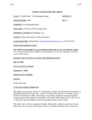
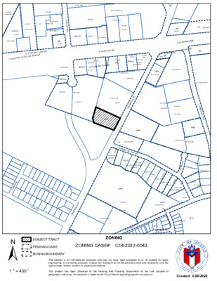
ZONING CHANGE REVIEW SHEET DISTRICT: 1 TO: LI CASE: C14-2022-0043 – 8110 Springdale Road ZONING FROM: I-RR ADDRESS: 8110 Springdale Road SITE AREA: 1.959 acres (85,334 square feet) PROPERTY OWNER: RCI Holdings, Inc. AGENT: St Elmo Brewing LLC (Bryan Winslow) CASE MANAGER: Michael Dietz; michael.dietz@austintexas.gov; (512) 974-7617 STAFF RECOMMENDATION: The Staff recommendation is to grant limited industrial services (LI) district zoning. For a summary of the basis of Staff’s recommendation, see the Case Manager Comments section of this report. ZONING AND PLATTING ACTION / RECOMMENDATION: July 19, 2022 CITY COUNCIL ACTION: September 1, 2022 ORDINANCE NUMBER: ISSUES: None at this time. CASE MANAGER COMMENTS: The subject rezoning area consists of one platted lot, which is located near the intersection of Springdale Road and Tuscany Way, south of U.S Route 290. The site is currently zoned as interim rural residence (I-RR), representing a low-density residential zoning designation assigned as part of the property’s annexation in December 2004 (Ordinance No. 041118-13). A creek abuts the rear property lines, flowing approximately north to south. The subject site is mostly rectangular in shape, although the southwest corner juts inward, likely due to the curvature of the creek. The site is currently developed with a vacant two- 1 of 9B-5 C14-2022-0043 Page 2 story commercial building and large parking lot, with a concrete wall towards the rear to separate the parking lot from the vegetated area near the creek. Numerous trees are located towards the front of the property and along the northern property line. Springdale Road is partially within the Austin city limits, but also runs outside of the city limits; the area immediately to the south of the subject property is within the City’s extraterritorial jurisdiction (ETJ). The portions of Springdale Road that are within the city limits feature primarily industrial uses, although there are also pockets of low-density residential uses and a small commercial corridor along U.S. Route 290. There are light industrial uses, including a truck rental business and plumbing supply store, to the north and west of the subject site (LI- CO). An undeveloped property zoned for low-density residential uses is to the east, across the road from the subject property (I-RR), although that property is surrounded by other properties zoned for limited industrial uses. The property to the south is undeveloped and is not located within the city limits. Please refer to Exhibits A (Zoning Map) and A-1 (Aerial …
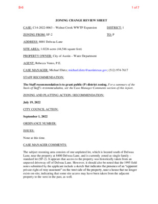
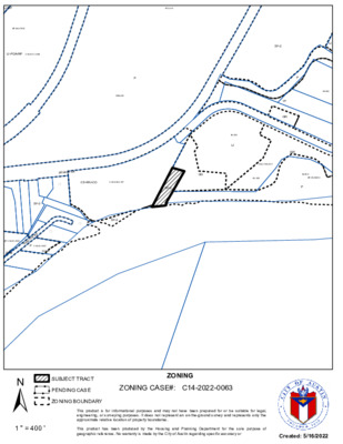
ZONING CHANGE REVIEW SHEET DISTRICT: 1 TO: P CASE: C14-2022-0063 – Walnut Creek WWTP Expansion ZONING FROM: SF-2 ADDRESS: 8001 Delwau Lane SITE AREA: 1.0226 acres (44,546 square feet) PROPERTY OWNER: City of Austin – Water Department AGENT: Rebecca Vento, P.E. CASE MANAGER: Michael Dietz; michael.dietz@austintexas.gov; (512) 974-7617 STAFF RECOMMENDATION: The Staff recommendation is to grant public (P) district zoning. For a summary of the basis of Staff’s recommendation, see the Case Manager Comments section of this report. ZONING AND PLATTING ACTION / RECOMMENDATION: July 19, 2022 CITY COUNCIL ACTION: September 1, 2022 ORDINANCE NUMBER: ISSUES: None at this time. CASE MANAGER COMMENTS: The subject rezoning area consists of one unplatted lot, which is located south of Delwau Lane, near the property at 8400 Delwau Lane, and is currently zoned as single family – standard lot (SF-2). It appears that access to the property was historically taken from an unpaved driveway off of Delwau Lane. However, it should also be noted that the 1995 field notes submitted by the applicant include a sketch that indicates the presence of an “apparent private right-of-way easement” on the west side of the property, near a house that no longer exists on-site, indicating that some site access may have been taken from the adjacent property to the west in the past, as well. 1 of 7B-6 C14-2022-0063 Page 2 According to the agent, the existing property features existing infrastructure for the Walnut Creek Wastewater Treatment Plant (“WWTP”), although most of the infrastructure is located below the finished grade. In particular, the subject site features an outfall structure, where a 96’’ subterranean effluent pipe terminates and discharges into the Colorado River. The subject site is mostly rectangular in shape and is currently undeveloped, aside from the aforementioned wastewater treatment infrastructure, most of which is underground. A 5-foot- wide electric easement bifurcates the site, running from the north property line to the east property line. Delwau Lane features a broad range of uses, including residential, commercial, industrial, and public land uses of varying intensities. There is a vehicular racetrack designed for motorsports, although the business operating the track has since closed, located primarily to the northeast. The parcels comprising the track feature different zoning designations (GO, LI, GR, and IP). To the east, more land is owned by the City of Austin and used for the Walnut Creek WWTP (P); this land is also to the …
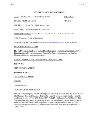
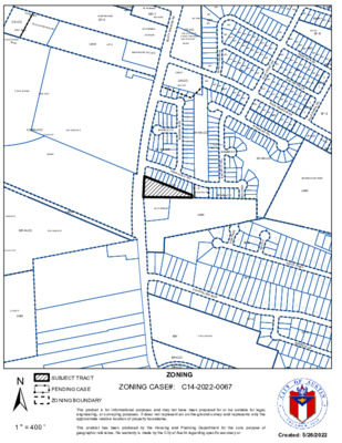
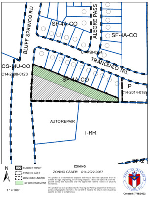
ZONING CHANGE REVIEW SHEET DISTRICT: 2 TO: SF-6 CASE: C14-2022-0067 – Villas at South Austin ZONING FROM: SF-4A-CO ADDRESS: 7311 and 7313 Bluff Springs Road SITE AREA: 1.2850 acres (55,975 square feet) PROPERTY OWNER: Srinivas Prudhvi Minnekanti & Vamshi Krishna Sunchu AGENT: Srinivas Prudhvi Minnekanti CASE MANAGER: Michael Dietz; michael.dietz@austintexas.gov; (512) 974-7617 STAFF RECOMMENDATION: The Staff recommendation is to grant townhouse and condominium residence (SF-6) district zoning. For a summary of the basis of Staff’s recommendation, see the Case Manager Comments section of this report. ZONING AND PLATTING ACTION / RECOMMENDATION: July 19, 2022 CITY COUNCIL ACTION: September 1, 2022 ORDINANCE NUMBER: ISSUES: None at this time. CASE MANAGER COMMENTS: The subject rezoning area consists of one platted lot, which is located near the intersection of Bluff Springs Road and Tranquilo Trail and is currently zoned as single family – small lot – conditional overlay (SF-4A-CO) district (C14-98-0224 – Ordinance No. 990506-65). The Conditional Overlay serves to restrict the project site and all other existing and previously authorized uses within the combining district to a maximum cumulative total of 2,000 vehicular trips per day and also to prohibit vehicular access from the subject property to Dakota Lane. 1 of 8B-7 C14-2022-0067 Page 2 It should also be noted that a Longhorn Pipeline gas easement is recorded over the subject property, as verified by the submitted survey. The easement requires a 50-foot building setback from the gas lines and additional building construction and design standards may be required for the proposed residential units, including the installation of fire sprinklers, a restriction on the proposed locations of windows, and limitations on construction materials designed to ensure that fire-resistive materials are used. The subject site is mostly triangular in shape and is currently undeveloped. Bluff Springs Road primarily features residential uses of varying densities. There are apartments to the west of the site (CS-MU-CO), single-family residences to the north and east (SF-4A-CO), and an automotive repair use to the south (I-RR). Please refer to Exhibits A (Zoning Map) and A-1 (Aerial Exhibit). The applicant has requested townhouse & condominium (SF-6) district zoning. The application indicates that the applicant intends to construct seven residential units on the property. The SF-6 district does not establish a maximum density or floor area ratio for each lot. However, the district does identify a maximum building height of 35 feet and a maximum building coverage of 40%. The …
ZONING CHANGE REVIEW SHEET CASE: C14-2022-0040 – Pioneer Hill Plaza Z.A.P. DATE: July 5, 2022 DISTRICT: 1 ADDRESS: 10017-1/2 Dessau Road and 1501-1/2 Arborside Drive AREA: 3.448 acres OWNER: Continental Homes of Texas (John Sparrow) APPLICANT: Doan & Associates (Julie Doan) ZONING FROM: MF-3-CO TO: CS SUMMARY STAFF RECOMMENDATION: Staff recommends GR-MU-CO. The conditional overlay would prohibit automotive rental, automotive sales, automotive repair services, automotive washing (of any type), and service station. An existing Traffic Impact Analysis (TIA) will be attached to the property via conditional overlay or public restrictive covenant. For a summary of the basis of staff’s recommendation, see case manager comments on page 2. ZONING AND PLATTING COMMISSION RECOMMENDATION: July 17, 2022: July 5, 2022: To grant postponement to July 17, 2022, as requested by applicant, on consent. CITY COUNCIL DATE: July 28, 2022: ORDINANCE READINGS: 1st 2nd 3rd ORDINANCE NUMBER: CASE MANAGER: Heather Chaffin e-mail: heather.chaffin@austintexas.gov PHONE: 512-974-2122 1 of 39B-8 C14-2022-0040 Page 2 ISSUES: The rezoning tract was included in a Traffic Impact Analysis (TIA) for the overall Pioneer Hill area that was approved in 2002 and amended in 2003 and 2011. At that time, the City of Austin attached TIA requirements via conditional overlay (CO) instead of via public restrictive covenant (RC). Staff recommends that the property remain subject to the TIA; City of Austin Law Department will determine whether a CO or RC is appropriate to tie the TIA to the property. DEPARTMENT COMMENTS: The subject property is located at the southeast corner of Dessau Road and Arborside Drive. The undeveloped property is currently zoned MF-3-CO, with the CO attaching TIA requirements as described in the Issues section. An unconstructed road right-of-way (ROW) is along the south side of the property (Edgeworth Bend), and unnamed streets are located along the east property lines. Property to the south and southeast is zoned MF-4 and includes undeveloped land and multifamily land uses. East of the rezoning tract are undeveloped SF-6-CO tracts; further northeast of the property are SF-6-CO tracts that are developed with small lot single family residences. Across Arborside Drive to the north is undeveloped land zoned MF-3-CO. Across Dessau Road to the west is a single family neighborhood zoned SF-3-NP. Please see Exhibits A and B- Zoning Map and Aerial Exhibit. The subject property was rezoned from Traditional Neighborhood Development (TND) to GR-CO and LI-CO in 2011. In addition to TIA requirements, the …
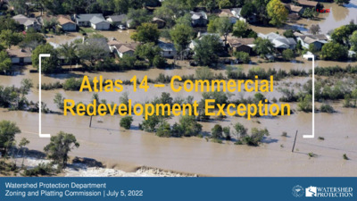
Atlas 14 – Commercial Redevelopment Exception Watershed Protection Department Zoning and Platting Commission | July 5, 2022 1 of 221 of 22 Floodplain Regulations Update What floodplain rules did we update? What floodplain rules do we recommend updating now? 2 2 of 222 of 22 What floodplain rules did we update? Most significant update to our floodplain rules in their 36-year history Goal of updated rules: Protect our residents from flooding based on a better understanding of flood risk with new rainfall information Updated four basic elements of rules • Floodplain definitions • Residential redevelopment exception • Colorado River exception • Freeboard 3 3 of 223 of 22 Residential Redevelopment Exception Administrative approval process floodplain if: 1. Replacement or modification of an existing residential building 2. Does not increase number of dwelling units 3. Finished floor elevation is at least 2 feet above the 100-year floodplain 4. No adverse flooding impact If these 4 conditions are met, the safe access requirement is waived Purpose • Incentivizes development that decreases flood risk • 80% of buildings in the 100-year floodplain are residential • Doesn’t increase the number of dwelling units at risk of flooding • Opens up opportunity for grant Existing condition Re-developed condition funding 4 4 of 224 of 22 Result of Collaborative Code Revision Process Contacted more than 2,700 people at 110 different meetings City Council approved the new rules on November 14, 2019 Staff pledged to develop draft rules regarding commercial redevelopment 5 5 of 225 of 22 What floodplain rules do we recommend updating now? Commercial Redevelopment Exception 6 6 of 226 of 22 Commercial Redevelopment exception Goal: Create an administrative approval process for commercial redevelopment that decreases flood risk compared to the existing conditions Considerations: Building use; square footage; occupant load; parking flood risk; building height 7 7 of 227 of 22 Proposed commercial redevelopment exception Administrative approval process for a commercial building in the floodplain if: 1. Replaces or modifies an existing commercial building 2. Finished floor elevation is at least 2 feet above the 100-year floodplain 4. Does not include the following uses: E (Educational); F (Factory); H (High Hazard); or I (Institutional) 5. Does not increase the number or flood level of parking spaces within the floodplain on the property unless otherwise required; and 3. Does not increase the building square 6. No adverse flooding impact footage on the property If these conditions …
ZONING & PLATTING COMMISSION AGENDA Tuesday, July 19, 2022 The Zoning and Platting Commission will convene at 6:00 PM on Tuesday, July 19, 2022 at Austin City Hall, Council Chambers, Room 1001 301 W. Second Street, Austin, TX. Some members of the Zoning and Platting Commission may be participating by videoconference. The meeting may be viewed online at: http://www.austintexas.gov/page/watch-atxn-live Cesar Acosta Nadia Barrera-Ramirez – Chair Scott Boone Ann Denkler – Parliamentarian Betsy Greenberg David King – Secretary Jolene Kiolbassa – Vice-Chair Hank Smith Lonny Stern Carrie Thompson Roy Woody EXECUTIVE SESSION (No public discussion) The Zoning & Platting Commission will announce it will go into Executive Session, if necessary, pursuant to Chapter 551 of the Texas Government Code, to receive advice from Legal Counsel on matters specifically listed on this agenda. The commission may not conduct a closed meeting without the approval of the city attorney. Private Consultation with Attorney – Section 551.071 PUBLIC COMMUNICATION The first four (4) speakers signed up prior to the speaker registration deadline will each be allowed a three-minute allotment to address their concerns regarding items not posted on the agenda. A. APPROVAL OF MINUTES 1. Approval of minutes from July 5, 2022. Attorney: Patricia Link, 512-974-2173 Commission Liaison: Andrew Rivera, 512-974-6508 B. PUBLIC HEARINGS 1. Rezoning: Location: Owner/Applicant: Peter Pham Phuong Request: Staff Rec.: Staff: C14-2022-0037 - 3131 E Howard Lane; District 1 3131 East Howard Lane, Harris Branch Watershed W/LO to GR-MU Recommendation of LR-MU Sherri Sirwaitis, 512-974-3057, sherri.sirwaitis@austintexas.gov Housing and Planning Department 2. Zoning: C14-2022-0074 - TXDOT 6; District 6 9203 ½ North Lake Creek Parkway, South Brushy Creek Watershed Location: Owner/Applicant: Avery Land Investors, LP (Alex Clarke) Alice Glasco Consulting (Alice Glasco) Agent: I-RR to MF-4 Request: Staff Rec.: Recommended Sherri Sirwaitis, 512-974-3057, sherri.sirwaitis@austintexas.gov Staff: Housing and Planning Department 3. Rezoning: Location: C814-2009-0139.03 - Bull Creek PUD Amendment #3; District 10 5305, 5400, 5404, 5408, 5505 Paradox Cove; 4909, 4915-1/2, 4929 FM 2222 Road, Bull Creek Watershed; Lake Austin Watershed Owner/Applicant: David G. Booth, Trustee for the David Booth Revocable Trust Agent: Request: Staff Rec.: Staff: Armbrust & Brown, PLLC (David Armbrust) PUD to PUD, to change conditions of zoning Pending Wendy Rhoades, 512-974-7719, wendy.rhoades@austintexas.gov Housing and Planning Department Postponement request by Staff to August 16, 2022 Postponement Request 4. Zoning: Location: C14-2021-0194 - Evelyn; Contiguous to District 1 6100 Blue Goose Road and 11815 Cameron Road, Harris Branch, Decker Creek, …
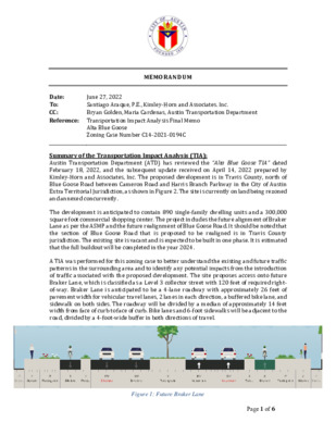
MEMORANDUM Date: To: CC: Reference: Transportation Impact Analysis Final Memo June 27, 2022 Santiago Araque, P.E., Kimley-Horn and Associates. Inc. Bryan Golden, Maria Cardenas, Austin Transportation Department Alta Blue Goose Zoning Case Number C14-2021-0194C Summary of the Transportation Impact Analysis (TIA): Austin Transportation Department (ATD) has reviewed the “Alta Blue Goose TIA” dated February 18, 2022, and the subsequent update received on April 14, 2022 prepared by Kimley-Horn and Associates, Inc. The proposed development is in Travis County, north of Blue Goose Road between Cameron Road and Harris Branch Parkway in the City of Austin Extra Territorial Jurisdiction, as shown in Figure 2. The site is currently on land being rezoned and annexed concurrently. The development is anticipated to contain 890 single-family dwelling units and a 300,000 square foot commercial shopping center. The project includes the future alignment of Braker Lane as per the ASMP and the future realignment of Blue Goose Road. It should be noted that the section of Blue Goose Road that is proposed to be realigned is in Travis County jurisdiction. The existing site is vacant and is expected to be built in one phase. It is estimated that the full buildout will be completed in the year 2024. A TIA was performed for this zoning case to better understand the existing and future traffic patterns in the surrounding area and to identify any potential impacts from the introduction of traffic associated with the proposed development. The site proposes access onto future Braker Lane, which is classified as a Level 3 collector street with 120 feet of required right- of-way. Braker Lane is anticipated to be a 4-lane roadway with approximately 26 feet of pavement width for vehicular travel lanes, 2 lanes in each direction, a buffered bike lane, and sidewalk on both sides. The roadway will be divided by a median of approximately 14 feet width from face of curb to face of curb. Bike lanes and 6-foot sidewalks will be adjacent to the road, divided by a 4-foot-wide buffer in both directions of travel. Figure 1: Future Braker Lane Page 1 of 6 As a transportation condition of approval for the above referenced zoning application, the applicant shall comply with the recommendations below: 1. Dedicate 120 feet of right-of-way per the ASMP for future Braker Lane at the time of final plat. 2. Design and construct Braker Lane extension and the realignment of Blue …
C14-98-0188 C14-2013-0105 SP-00-2032C(XT3) LI-CO C14-98-0142 98-0189 97-0071 LI C14-98-0189 SP-06-0441C C14-97-0071 SP-01-0398C T U S C A N Y W A Y LI-CO C14-00-2120 98-0188 00-2120 GR-CO C14-98-0188 SP-04-0074 CS-CO 00-2070 SP07-0054C E U S 2 90 H W Y S V R D W B C R O S S PA R K T O E U S 2 9 0 W B R A M P E U S 2 90 H W Y W B FO O D SAL E S C O N V. STO R E G A S E US 290 EB RAM P GR G AS C14-96-0030 GR-CO 96-0030 C14-96-0030 E U S 2 9 0 H W Y S V R D EB 97-0111 05-0164 DR C14-03-0054 GR-CO 03-0054 SP-03-0305CS C14-05-0164 05-0164 041118-13 I-RR SP-02-0425D C14-2009-0015 GR 94-160 97-0111 GR-CO LI-CO C14-97-0111 97-0111 DR WH SE LO S P 9 7 - 0 28 3 C E U S 2 9 0 W B R A M P E U S 2 9 0 H W Y E B DR C14-2011-0068 P F E R G U S O N C T O F I-RR C14-2013-0026 LI-CO 041118-13 C7A-04-021 C14-2011-0143 SP-04-0118D C14-06-0108 06-0108 D E R L A D G RIN P S ! ! ! ! ! ! ! ! ! ! ! ! ! ! I-RR ! ! ! ! ! ! ! ! ! ! I-RR LI C14-2019-0076 4 1 2 0 - 5 0 COMMERCIAL PARK DR C14-05-0214 LI-CO I-SF-2 2008-0157 C7A-04-021 C14-2008-0157 041118-13 SP-05-1315D D LV Z B N A D A N D TR E E BLV D D U K E R D ± SUBJECT TRACT ! ! ! ! ! ! PENDING CASE ZONING BOUNDARY I-SF-2 C7A-04-021 041118-13 C14-05-0216 05-0216 73 1 05-0 C14-05-0173 56 1 05-0 I-SF-2 C14-05-0156 LI-CO 05-0206 R D A G O T L A 91 1 05-0 C14-05-0191 CS-1-CO 06-0227 I-RR 041118-13 C7A-04-021 D E R L A D G RIN P S LI-CO C14-05-0084 LI-CO C14-2013-0149 C R Y S T A L B R O O K W E S T SF-2 BI G W I N D W AY P C14-2014-0022 SF-2 C14-2013-0070 O L D M A N O R R D ZONING ZONING CASE#: C14-2022-0043 This product is for informational purposes and may not have been prepared for or be suitable for legal, engineering, …
LI-NP SP-94-0351C LI-PDA-NP C14-2017-0148 P72-013 P R86-032 D E LWA U L N ( CS-MU-CO C14-2019-0137 ( SF-2 ! ! ! ! ! ! GO ! ! ! ! ! SF-2 ! ! ! ! ! ! ! ! ! ! ! ( SF-2 ( D N R O E L T P H S C14-03-0052 03-0052 P C14-03-0052 SF-2 SF-2 LI P 84-429 IP GR GR 84-429 LI C14-2016-0017 80-066 84-429 SP-06-0406C P ± SUBJECT TRACT ! ! ! ! ! ! PENDING CASE ZONING BOUNDARY ZONING ZONING CASE#: C14-2022-0063 This product is for informational purposes and may not have been prepared for or be suitable for legal, engineering, or surveying purposes. It does not represent an on-the-ground survey and represents only the approximate relative location of property boundaries. 1 " = 400 ' This product has been produced by the Housing and Planning Department for the sole purpose of geographic reference. No warranty is made by the City of Austin regarding specific accuracy or Created: 5/16/2022 IP 84-429 LI GR C14-2016-0017 P DELWAU LN CS-MU-CO C14-2019-0137 SF-2 SF-2 N22 ! ! ! ! ! ! ! ! ! ! GO ! C14-2022-0063 ! ! SF-2 ! ! ! ! ! ! ! ! ! P N21 ± SUBJECT TRACT ZONING BOUNDARY ! ! ! ! ! ! PENDING CASE CREEK BUFFER Walnut Creek WWTP Expansion to 100 Million Gallons Per Day ZONING CASE#: LOCATION: SUBJECT AREA: GRID: MANAGER: C14-2022-0063 8001 Delwau Lane 1.023 Acres N22 Wendy Rhoades 1 " = 200 ' This product has been produced by the Housing and Planning Department for the sole purpose of geographic reference. No warranty is made by the City of Austin regarding specific accuracy or completeness. Created: 6/13/2022
C14-93-0086 CS-CO SP97-0289C ADULT\ORIENTED\USE C14-2018-0069 86-327 I-RR APTS. C14-84-457(RCA) GR RV PARKING MF-1 84-457RC CAMPGROUND SF-3 D R S G N I R P S F F U L B 99-2089 CS-CO C14-2017-0022 C14-95-0181 C14-2011-0127 UNDEV 84-302 RV PARKING STORAGE WAREHOUSE (VACANT) CS-MU-CO C14-2008-0123 C7a01-017 SF-4A-CO I-RR AUTO REPAIR I-RR MH MH MH MH MH MH MH MH MH MH MH 83-340 SF-6 MH MH MH MH MH MH MH MH MH MH D E E R R U N D R MH MH MH MH M H MH MH MH MH MH = SF-3 MH MH MH MH MH MH MH MH MH MH MH MH MH MH MH M H MH MH MH MH MH MH MH MH MH MH MH M H MH MH MH MH MH N L M U G E C U R P S MH MH MH R K D E E R M C EL MH MH MH MH MH M H MH MH MH O A K M MH MH MH MH O T T E L N MH M H MH MH MH MH MH MH MH MH MH MH M H MH MH = SF-3 = MH M H MH M H BL U E M MH M H MH MH MH E A D O W D R MH SF-3 = = L R N T W A E D U L B SF-3 MH MH MH N O G A L E S T R L SF-4A-CO P-CO 93-0 0 48 SF-3 KENDRA PAGE PARK I-RR UNDEV LR-CO 98-0224 ( ( ( ( ( ( ( ( ( ( ( ( ( ESPINO CV ( ( ( ( ( ( S S A P E R G E L A SF-4A-CO ( ( ( ( ( ( ( ( ( ( ( ( ( ( ( ( ( ( ( ( ( ( ( ( ( C14-98-0224 98-0224 SOMBRA CV L R T O T N A C N E ( ! ! ! ! ! ( ( ! ! ( ( TRANQUILO TRL ( ( ( ( ! SF-4A-CO ! ! ! ! P C14-2014-0189 ( ! ! ( ! ! ! ! ! ! ! ! ! ! SF-4A-CO S S A P N A D ( SF-2 SF-2 ( ( S S A P N A D ( ( SF-2 ( ( ( ( …
( ( SF-4A-CO ( ( ( ( ( ( ( ( ( ( ( ( ( ( ( ( S S A P E R G E L A ( C14-98-0224 ( SF-4A-CO CS-MU-CO ! ! C14-2008-0123 ! ! ! ( ( ( TRANQUILO TRL ( ( ! SF-4A-CO ! ! ! ! ( ( ( ! ! ! ! P C14-2014-0189 ! ! ! ! ! ! ! I D R S G N R P S F F U L B ! ! ! AUTO REPAIR I-RR ± SUBJECT TRACT ! ! ! ! ! ! PENDING CASE ZONING ZONING CASE#: C14-2022-0067 ZONING BOUNDARY 50' GAS EASEMENT This product is for informational purposes and may not have been prepared for or be suitable for legal, engineering, or surveying purposes. It does not represent an on-the- ground survey and represents only the approximate relative location of property boundaries. 1 " = 100 ' This product has been produced by the Housing and Planning Department for the sole purpose of geographic reference. No warranty is made by the City of Austin regarding specific accuracy or completeness. SF-2 Created: 7/18/2022
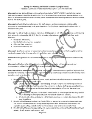
Zoning and Platting Commission Resolution (King version 2) Floodplain Commercial Redevelopment Exception Code Amendments Whereas the new National Oceanic Atmospheric Association “NOAA” ATLAS 14 rainfall information indicated increased rainfall levels within the City of Austin and the city adopted new regulations in an effort to protect the residents from flooding based on a better understanding of flood risk with this new rainfall information; and, Whereas the Austin City Council directed City staff, boards, and commissions to initiate public processes to consider proposed code amendments to City floodplain regulations based on Atlas 14 floodplain data; and Whereas The City of Austin contacted more than 2,700 people at 110 different meetings and following that outreach on November 14, 2019 the City of Austin adopted new regulations with four basic elements: • Floodplain definitions, • Residential redevelopment exception, • Colorado River exception, • Increased Freeboard, and Whereas A significant number of residential and commercial properties are in the floodplain and that number increased when the new Atlas 14 regulations were adopted; and Whereas the key goals of the code amendments are to increase public safety and decrease flood risks; and, Whereas the City Council and City of Austin are committed to equity in the development and implementation of land development policies and code amendments. Now, therefore, be it resolved that the Zoning and Platting Commission encourages the City Council to consider the following recommendations regarding the proposed floodplain commercial redevelopment exception code amendments: 1. Direct the City Manager to provide annual public updates on the following recommendations from the Flood Mitigation Task Force: a. City Council should conduct a periodic (e.g. every 5 years) financial and organizational audit of the Watershed Protection Department to evaluate staffing resource allocations, program effectiveness, and the successful implementation of master plan goals and objectives, b. The City should not grant variances for development or redevelopment that may lead to future flooding or annex property that may already be a flood concern, c. Work with city, state, and county authorities to continue to restrain development in 100- year floodplains, 2. Direct the City Manager to direct the Equity Office to review the proposed code amendments and provide recommendations for equitable implementation of the code amendments and equitable public safety protections for communities of color and low-income families, 3. Direct the City Manager to require City civil engineers and City public safety officials to certify all waivers of safe …
Zoning and Platting Commission Resolution Floodplain Commercial Redevelopment Exception Code Amendments Whereas the new National Oceanic Atmospheric Association “NOAA” ATLAS 14 rainfall information indicated increased rainfall levels within the City of Austin and the city adopted new regulations in an effort to protect the residents from flooding based on a better understanding of flood risk with this new rainfall information; and, Whereas The City of Austin contacted more than 2,700 people at 110 different meetings and following that outreach on November 14, 2019 the City of Austin adopted new regulations with four basic elements: • Floodplain definitions • Residential redevelopment exception • Colorado River exception; and • Increased Freeboard Whereas There are a significant number of residential and commercial properties that are in the flood plain and that number increased when the new Atlas 14 regulations were adopted; and Whereas The City has a goal to Create an administrative approval process for commercial redevelopment that decreases flood risk compared to the existing conditions Whereas the City Council and City of Austin are committed to equity in the development and implementation of land development policies and code amendments. Now, therefore, be it resolved that the Zoning and Platting Commission encourages the City Council to consider the following recommendations regarding the proposed floodplain commercial redevelopment exception code amendments: 1. The administrative approval process for a commercial building in the flood plain should be adopted if: a. Replaces or modifies an existing commercial building b. Finished floor elevation is at least 2 feet above the 100-year floodplain c. Does not increase the building square footage on the property d. Does not include the following uses: i. E (educational); ii. F (Factory iii. H (High Hazard) iv. I (Institutional) e. Does not increase the number or flood level of parking spaces within the flood plain on the property unless otherwise required; and f. No adverse Flooding Impact 2. Direct the City Manager to provide annual public reports on the efficacy of floodplain redevelopment exceptions and the goals to increase public safety and decrease flood risks in floodplains, and
Improving Connectivity Resolution Zoning and Platting Commission Whereas; Priority Program 1 in the Imagine Austin Comprehensive Plan calls for “investment in a compact and connected city through the coordination of capital investments, incentives, and regulations;” and Whereas; according to the 2020 Imagine Austin Compact and Connected Indicators, developed land area, annual unlinked transit passenger trips, vehicle miles traveled per capita, percentage of trips by biking and walking, and transportation system total annual delay are all “headed in the wrong direction;” and Whereas; fatalities, serious injuries, and total crashes in Austin have increased year over year in the Austin area since 2018; and Whereas; designing communities with options for bicycling and walking increases opportunities for physical activity, especially for children and families; and Whereas; car ownership in Texas costs almost $10,000 a year; and Whereas; dead-end streets and disconnected networks increase vehicle miles traveled and time spent in the car, which have been associated with obesity, decreased opportunities for active travel, stress, impacts on mental health, less time to spend with family and friends, and less time to engage in community activities. Whereas, connected street networks help reduce traffic on major thoroughfares, are cheaper to build and maintain; and Whereas a connected street grid makes walking, biking, and transit use more desirable options; and Whereas, the way streets are laid out now determines the pattern for future growth; and Whereas subdivisions with too few access streets results in dangerous situations in the event of flooding or wildfires; and Therefore, be it resolved that the Zoning and Platting Commission recommend that the Austin City Council seek to revise and amend Land Development Code sections § 25-4-151 through § 25-4-157 to meet the intent of Imagine Austin Priority Program and seek to enhance connectivity and affordability in new subdivision design; and Be it further resolved that the proposed changes recommended by the Zoning and Platting Commission are: 1. § 25-4-151 – Require connections and alignment of all stub out streets of a new subdivision to existing or proposed streets. If street connection infeasible, provide connection through a multi- use trail; and 2. § 25-4-152 – Prohibit dead-end streets and/or cul-de-sacs unless the director determines that topography, natural features, or unusual conditions make connection to an existing or proposed street infeasible; and 3. § 25-4-152 – If allowed by the director, a dead-end street and/or cul-de-sac must be no longer than 300 feet and …