02 C14-2026-0001 - 3416 Davis Lane; District 5 - Staff Report — original pdf
Backup
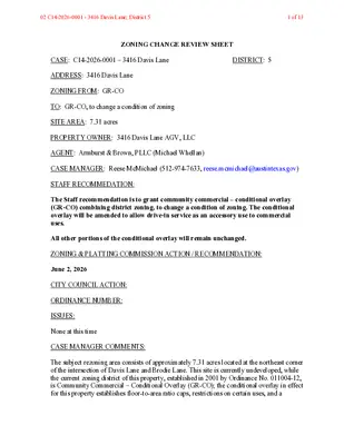
ZONING CHANGE REVIEW SHEET CASE: C14-2026-0001 – 3416 Davis Lane DISTRICT: 5 ADDRESS: 3416 Davis Lane ZONING FROM: GR-CO TO: GR-CO, to change a condition of zoning SITE AREA: 7.31 acres PROPERTY OWNER: 3416 Davis Lane AGV, LLC AGENT: Armburst & Brown, PLLC (Michael Whellan) CASE MANAGER: Reese McMichael (512-974-7633, reese.mcmichael@austintexas.gov) STAFF RECOMMEDATION: The Staff recommendation is to grant community commercial – conditional overlay (GR-CO) combining district zoning, to change a condition of zoning. The conditional overlay will be amended to allow drive-in service as an accessory use to commercial uses. All other portions of the conditional overlay will remain unchanged. ZONING & PLATTING COMMISSION ACTION / RECOMMENDATION: June 2, 2026 CITY COUNCIL ACTION: ORDINANCE NUMBER: ISSUES: None at this time CASE MANAGER COMMENTS: The subject rezoning area consists of approximately 7.31 acres located at the northeast corner of the intersection of Davis Lane and Brodie Lane. This site is currently undeveloped, while the current zoning district of this property, established in 2001 by Ordinance No. 011004-12, is Community Commercial – Conditional Overlay (GR-CO); the conditional overlay in effect for this property establishes floor-to-area ratio caps, restrictions on certain uses, and a 02 C14-2026-0001 - 3416 Davis Lane; District 51 of 13 prohibition on drive-in service as an accessory use to commercial uses. Please refer to Exhibit D (Ordinance No. 011004-12). Adjacent land uses consists of multifamily residences and undeveloped land to the east, multifamily residences to the north, single family residences and commercial uses to the south, and open space and multifamily residences to the west. Please refer to Exhibits A (Zoning Map) and B (Aerial View). As for the transportation context of the larger vicinity surrounding this property, the Austin Strategic Mobility Plan (ASMP) identifies Davis Lane as a level 2 street, while Brodie Lane is established as a level 3 street. This property is approximately one mile north of the intersection of Slaughter Lane, an Imagine Austin corridor, and Brodie Lane. The applicant is requesting that the prohibition on drive-in service as an accessory use to commercial uses be removed from the conditional overlay. This would allow the applicant to provide neighborhood-serving commercial uses which could include a low-intensity drive- through accessory use. Staff is recommending Community Commercial – Conditional Overlay (GR-CO) combining district zoning with the modification to the conditional overlay because of the site’s proximity to Brodie Lane - a major corridor, and Davis Lane as well as being nearby to other commercial services. BASIS OF RECOMMENDATION: 1. The proposed zoning should be consistent with the purpose statement of the district sought. The Community Commercial (GR) district is intended for an office or other commercial use that serves neighborhood and community needs and that generally is accessible from major traffic ways. The Conditional Overlay (CO) combining district may be applied in combination with any base district. The district is intended to provide flexible and adaptable use or site development regulations by requiring standards tailored to individual properties. 2. Zoning changes should promote compatibility with adjacent and nearby uses and should not result in detrimental impacts to the neighborhood character. Staff is recommending the applicant’s proposed rezoning because similar land uses characterize many of the properties surrounding the site in question; therefore, allowing drive-in service as an accessory to commercial uses would not be inappropriate among the prevailing land uses within the vicinity. 3. No change in conditions has occurred within the area indicating that there is a basis for changing the originally established zoning and/or development restrictions for the property. 02 C14-2026-0001 - 3416 Davis Lane; District 52 of 13 Since the existing zoning for this property was established in 2001, going from RR to GR-CO, the area surrounding this property has undergone noticeable changes. Davis Lane has been extended and widened from a two lane road to a five lane road with bike lanes and sidewalks. Meanwhile all of the parcels surrounding this property have transitioned from undeveloped farmland at the time the current zoning was established to multi-family residential properties and commercial properties. As a result of these changes, allowing drive-in service would be consistent with nearby commercial services in the area. EXISTING ZONING AND LAND USES: ZONING LAND USES GR-CO Site North MF-2-CO South GR-CO; SF-6-CO East West RR; MF-2-CO LR; GR; MF-2-CO Undeveloped Multifamily Residential Commercial, Single Family Residential Open Space, Multifamily Residential Open Space, Multifamily Residential NEIGHBORHOOD PLANNING AREA: N/A WATERSHED: Williamson Creek – Barton Springs Zone CAPITOL VIEW CORRIDOR: No SCENIC ROADWAY: No SCHOOLS: Austin Independent School District Cowan Elementary School Covington Middle School Bowie High School COMMUNITY REGISTRY LIST: Austin Independent School District Onion Creek Homeowners Association South Austin Neighborhood Alliance Friends of Austin Neighborhoods Save Our Springs Alliance TNR – Balcones Canyonlands Preserve AREA CASE HISTORIES: Preservation Austin Go Austin Vamos Austin 78745 Austin Neighborhoods Council Homeless Neighborhood Association Brodie Lane Homeowners Assn. NUMBER C14-00-2251 REQUEST RR to, DR, SF-6, SF-6-CO, LR, LR-CO, GR to GR-CO and MF- 2-CO COMMISSION Postponed to 4/10/01 (03/27/2001) To approve Staff’s recommendation of GR for Tract 1 and MF-2- CITY COUNCIL Approved as ZAP recommended (10/04/2001) 02 C14-2026-0001 - 3416 Davis Lane; District 53 of 13 CO for Tract 2 RELATED CASES: ADDITIONAL STAFF COMMENTS: Comprehensive Planning Project Name and Proposed Use: 3416 DAVIS LANE. C14-2026-0001. Project: 3416 Davis Lane. 7.31 acres from GR-CO to GR-CO. Existing: vacant. Proposed: Clinic, Strip Retail Plaza, and Coffee/Donut/Drive-Thru. Applicant seeks to amend the conditional overlay to remove the restriction on drive-thru service. Yes Imagine Austin Decision Guidelines Complete Community Measures * Imagine Austin Growth Concept Map: Located within or adjacent to an Imagine Austin Activity Center, Imagine Austin Activity Corridor, or Imagine Austin Job Center as identified the Growth Concept Map. Names of Activity Centers/Activity Corridors/Job Centers *: Mobility and Public Transit *: Located within 0.25 miles of public transit stop and/or light rail station. Y Mobility and Bike/Ped Access *: Adjoins a public sidewalk, shared path, and/or bike lane. • Sidewalk and bike lane present along Brodie LN Y Connectivity, Good and Services, Employment *: Provides or is located within 0.50 miles to goods and services, and/or employment center. • Goods and Services present along Brodie LN Connectivity and Food Access *: Provides or is located within 0.50 miles of a grocery store/farmers market. Connectivity and Education *: Located within 0.50 miles from a public school or university. Connectivity and Healthy Living *: Provides or is located within 0.50 miles from a recreation area, park or walking trail. Y Connectivity and Health *: Provides or is located within 0.50 miles of health facility (ex: hospital, urgent care, doctor’s office, drugstore clinic, and/or specialized outpatient care.) • Multiple health facilities located along Brodie LN; Clinic proposed at site Housing Choice *: Expands the number of units and housing choice that suits a variety of household sizes, incomes, and lifestyle needs of a diverse population (ex: apartments, triplex, granny flat, live/work units, cottage homes, and townhomes) in support of Imagine Austin and the Strategic Housing Blueprint. Housing Affordability *: Provides a minimum of 10% of units for workforce housing (80% MFI or less) and/or fee in lieu for affordable housing. Mixed use *: Provides a mix of residential and non-industrial uses. 02 C14-2026-0001 - 3416 Davis Lane; District 54 of 13 Culture and Creative Economy *: Provides or is located within 0.50 miles of a cultural resource (ex: library, theater, museum, cultural center). Culture and Historic Preservation: Preserves or enhances a historically and/or culturally significant site. Creative Economy: Expands Austin’s creative economy (ex: live music venue, art studio, film, digital, theater.) Workforce Development, the Economy and Education: Expands the economic base by creating permanent jobs, especially in industries that are currently not represented in a particular area or that promotes a new technology, and/or promotes educational opportunities and workforce development training. Industrial Land: Preserves or enhances industrial land. Not located over Edwards Aquifer Contributing Zone or Edwards Aquifer Recharge Zone 3 Number of “Yes’s” Drainage The developer is required to submit a pre- and post-development drainage analysis at the subdivision and site plan stage of the development process. The City’s Land Development Code and Drainage Criteria Manual require that the Applicant demonstrate through engineering analysis that the proposed development will have no identifiable adverse impact on surrounding properties. Environmental This site is located over the Edwards Aquifer Recharge Zone. The site is in the Williamson Creek Watershed of the Colorado River Basin, which is classified as a Barton Springs Zone Watershed by Chapter 25-8 of the City’s Land Development Code. It is in the Drinking Water Protection Zone. Project applications at the time of this report are subject to the SOS Ordinance that allows 15% impervious cover in the recharge zone. According to floodplain maps there is no floodplain within or adjacent to the project location. Standard landscaping and tree protection will be required in accordance with LDC 25-2 and 25-8 for all development and/or redevelopment. At this time, site specific information is unavailable regarding vegetation, areas of steep slope, or other environmental features such as bluffs, springs, canyon rimrock, caves, sinkholes, and wetlands. Under current watershed regulations, development or redevelopment requires water quality control with increased capture volume and control of the 2 year storm on site. Runoff from 02 C14-2026-0001 - 3416 Davis Lane; District 55 of 13 the site is required to comply with pollutant load restrictions as specified in Land Development Code. At this time, no information has been provided as to whether this property has any preexisting approvals that preempt current water quality or Code requirements. PARD – Planning & Design Review Parkland dedication fees may apply to any future site or subdivision applications resulting from this rezoning. As of January 1, 2024, new commercial, non-residential uses are not subject to parkland dedication requirements at the time of site plan and subdivision. However, APR is interested in discussion the potential of parkland on the lot to extend the Davis Hill Neighborhood Park. Please reach out to this reviewer to discuss: ann.desanctis@austintexas.gov. Site Plan FYI: All comments regarding the effects of the proposed rezoning on subsequent Site Plan Review applications are intended to assist in identifying potential development constraints but do not include all regulations which may affect a specific proposal. Changes to property boundaries and requests for development cannot include all regulatory limitations which may apply to a specific subject to modification or reconsideration if affected by a change in property boundaries or if development is proposed on only a portion of the land proposed for rezoning. These comments are intended to assist in identifying potential development constraints, but do not address the actual restrictions which will apply to a specific development proposal. Austin Development Services offers a variety of pre- application review options to assist in evaluating specific development proposals prior to Site Plan Application. Site plans will be required for any new development except for residential only project with up to 4 units. Any new development is subject to Subchapter E. Design Standards and Mixed Use. Additional comments will be made when the site plan is submitted. Compatibility Standards The site is not subject to compatibility standards due to the Hazardous Pipeline Overlay The Williams Hazardous Pipeline crosses this site. Additional review by AFD will be required at site plan review. Transportation – Engineering Review 02 C14-2026-0001 - 3416 Davis Lane; District 56 of 13 The Austin Strategic Mobility Plan (ASMP) calls for 116 feet of right-of-way for Brodie Lane. It is recommended that 58 feet of right-of-way from the existing centerline should be dedicated for Brodie Lane according to the Transportation Plan with the first subdivision or site plan application. [LDC 25-6-51 and 25-6-55]. The Austin Strategic Mobility Plan (ASMP) calls for 72 feet of right-of-way for Davis Lane. It is recommended that 36 feet of right-of-way from the existing centerline should be dedicated for Davis Lane according to the Transportation Plan with the first subdivision or site plan application. [LDC 25-6-51 and 25-6-55]. The adjacent street characteristics table is provided below: Name ASMP Classification ASMP Required ROW Existing ROW Existing Pavement Sidewalks Bicycle Route Brodie Lane Davis Lane 3 2 116’ 72’ 80’ 76’ 68’ 42’ Yes No Bike Lane No Capital Metro (within ¼ mile) No No Assessment of required transportation mitigation, including the potential dedication of right of way and easements and participation in roadway and other multi-modal improvements, will occur at the time of site plan application. A transportation assessment/traffic impact analysis shall be required at the time of site plan if triggered per LDC 25-6-113 and TCM 10.2.1 Austin Water Utility No comments on zoning change. FYI: The landowner intends to serve the site with existing City of Austin water utilities. Depending on the development plans submitted, water and or wastewater service extension requests may be required. All water and wastewater construction must be inspected by the City of Austin. For more information pertaining to the Service Extension Request process and submittal requirements contact the Austin Water SER team at ser@austintexas.gov. INDEX OF EXHIBITS AND ATTACHMENTS TO FOLLOW: Exhibit A: Zoning Map Exhibit B: Aerial Photograph Exhibit C: Applicant’s Summary Letter Exhibit D: Ordinance No. 011004-12 02 C14-2026-0001 - 3416 Davis Lane; District 57 of 13 Exhibit A02 C14-2026-0001 - 3416 Davis Lane; District 58 of 13 !!!!!!!!!!!!!!!!!!!!!!!!!!!!!!!!!!!!!!!!!!!!!!!!!!!!!!!!!!!(!(!(!(!(!(!(!(!(!(!(!(!(!(!(!(!(!(!(!(!(!(!(!(!(!(!(!(!(!(!(!(!(!(!(!(!(!(!(!(!(!(!(!(!(!(!(!(!(!(!(!(!(!(!(!(!(!(!(!(!(!(!(!(!(!(!(!(!(!(!(!(!(!(!(!(!(!(!(!(!(!(!(!(!(!(!(!(!(!(!(!(!(!(!(!(!(!(!(!(!(!(!(!(!(!(!(!(!(!(!(!(!(!(!(!(!(!(C14-2026-0001C14-03-0157C14-00-2251C14-96-0052C814-04-0024C14-90-0053C14-90-0053C14-90-0053C814-04-0024.02C14-95-0025C14-2023-0068C14-95-0026C14-2018-0122C14-03-0082C14-86-116C14-2009-0111C14-2022-0051C14-05-0151C14-2017-0095DAVIS LNBRODIE LNDEER LNCAMERON LOOPPINEY CREEK BNDPLANTATION RDCASPIAN DRDUNN STBENTON STHORNET DRDUNLIEGH DRDANDELION TRLPEPPERGRASS CVWAVERTREE CTSF-6-COMF-2-COMF-1RRPUDSF-2RRMF-2-COSF-3GR-COLRGR-COPLOLRDRRRSF-2I-RRSF-3SF-1SF-2GR-COLR-COSF-1LRSF-3SF-2SF-3SF-2GR-COGRSF-2GRSF-3SF-3SF-2SF-6-COPSF-3SF-2CS-13416 Davis Lane±This product has been produced by Austin Planning for the sole purpose of geographic reference. No warranty is madeby the City of Austin regarding specific accuracy or completeness.ZONING CASE#:LOCATION:SUBJECT AREA:MANAGER:C14-2026-00013416 Davis Ln7.31 AcresNancy EstradaCreated: 2/3/2026SUBJECT TRACTZONING BOUNDARY!!!!!PENDING CASECREEK BUFFER1 inch equals 400 'Exhibit B02 C14-2026-0001 - 3416 Davis Lane; District 59 of 13 December 15, 2025 Joi Harden, Zoning Officer City of Austin Housing and Planning Department 1000 E. 11th St. Austin, Texas 78702 Re: Rezoning request for the property located at 3416 Davis Lane, also known as TCAD Parcel No. 0422250511 (the “Property”) Dear Ms. Harden, On behalf of 3416 Davis Lane AGV, LLC (the “Applicant”), please accept the attached application requesting that the City rezone the Property to amend the existing conditional overlay. The Property is a 7.31-acre tract located at the northwest corner of Davis Lane and Brodie Lane. The Property was rezoned in 2001 to Community Commercial-Conditional Overlay (“GR-CO”) under Ordinance No. 011004-12. The conditional overlay includes floor-to-area ratio caps, restrictions on certain uses, and a prohibition on drive-in service as an accessory use to commercial uses. The Applicant is proposing to develop the Property with neighborhood-serving commercial uses, including a low-intensity drive-through accessory use. As a result, we are seeking to amend the conditional overlay to remove the drive-through prohibition on Tract 1. No other changes are requested. The Property is an appropriate place for a business with a small drive-through accessory use given its location at the intersection of Davis Lane and Brodie Lane. This is a signalized intersection designed to accommodate neighborhood-serving commercial activity, and Brodie Lane is classified as a Level 3 roadway in the Austin Strategic Mobility Plan (“ASMP”). The site layout will provide adequate on-site queuing and circulation to prevent spillback into the public rights-of-way. Additionally, in 2013 – over a decade after the Property was rezoned to its current entitlements – the City extended and realigned Davis Lane to create the four-way signalized intersection that exists today. When the Property was rezoned in 2001, Davis Lane dead-ended into Brodie Lane as a two-lane local road. Today, the improved intersection includes dedicated and protected left-turn lanes, along with marked, signal-controlled pedestrian crossings on all approaches. Given these updated conditions, a low-intensity drive-through use is appropriate, consistent with the ASMP roadway classification, and does not introduce a use type or traffic volumes that are incompatible with the surrounding transportation network. Thank you for your time and consideration. Please contact me if you have questions about this application or if you need additional information. Respectfully, Michael J. Whellan Exhibit C02 C14-2026-0001 - 3416 Davis Lane; District 510 of 13 Exhibit D02 C14-2026-0001 - 3416 Davis Lane; District 511 of 13 02 C14-2026-0001 - 3416 Davis Lane; District 512 of 13 02 C14-2026-0001 - 3416 Davis Lane; District 513 of 13