03 C14-2026-0023 - 8863 Anderson Mill Road; District 6 - Staff Report — original pdf
Backup
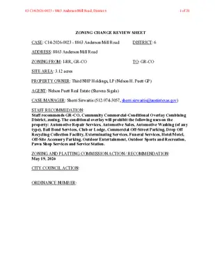
ZONING CHANGE REVIEW SHEET CASE: C14-2026-0023 - 8863 Anderson Mill Road DISTRICT: 6 ADDRESS: 8863 Anderson Mill Road ZONING FROM: I-RR, GR-CO TO: GR-CO SITE AREA: 3.12 acres PROPERTY OWNER: Third NHP Holdings, LP (Nelson H. Puett GP) AGENT: Nelson Puett Real Estate (Shawna Sigala) CASE MANAGER: Sherri Sirwaitis (512-974-3057, sherri.sirwaitis@austintexas.gov) STAFF RECOMMEDATION: Staff recommends GR-CO, Community Commercial-Conditional Overlay Combining District, zoning. The conditional overlay will prohibit the following uses on the property: Automotive Repair Services, Automotive Sales, Automotive Washing (of any type), Bail Bond Services, Club or Lodge, Commercial Off-Street Parking, Drop Off Recycling Collection Facility, Exterminating Services, Funeral Services, Hotel/Motel, Off-Site Accessory Parking, Outdoor Entertainment, Outdoor Sports and Recreation, Pawn Shop Services and Service Station. ZONING AND PLATTING COMMISSION ACTION / RECOMMENDATION: May 19, 2026 CITY COUNCIL ACTION: ORDINANCE NUMBER: 03 C14-2026-0023 - 8863 Anderson Mill Road; District 61 of 20 C14-2026-0023 ISSUES: N/A CASE MANAGER COMMENTS: 2 The property in question is a suite developed with a commercial strip center that fronts Anderson Mill Road. The lots to the north, across Anderson Mill Road, contain single family residences currently designated I-SF-2. The tracts of land to the south and east are developed with public schools (Deer Park Middle School and Live Oak Elementary School) designated I-RR. To the west, there is an undeveloped tract of land and townhouse residences zoned LR- MU-CO. In this request, the applicant is asking to zone the property to GR-CO, Community Commercial-Conditional Overlay Combining District, zoning to bring the existing uses on the site into conformance with City of Austin Land Use regulations. The applicant proposes to maintain the current conditional overlay from the previous GR-CO zoning case for the restaurant footprint in this shopping center from zoning case C14-2022-0041 (please see Ordinance No. 20220728-135 - Exhibit C). The staff is recommending GR-CO, Community Commercial-Conditional Overlay District, zoning for the property under consideration. The proposed GR-CO zoning will allow for low intensity office and commercial uses on a lot that front onto an arterial roadway, Anderson Mill Road. GR-CO zoning will permit the applicant to develop and maintain limited commercial uses on a property adjacent to the residential neighborhoods to the north. The proposed zoning will permit the applicant to bring the existing uses on the site into conformance the land use regulations in the City of Austin Code. The applicant agrees with the staff’s recommendation. BASIS OF RECOMMENDATION: 1. The proposed zoning should be consistent with the purpose statement of the district sought. The Community Commercial (GR) district is the designation for an office or other commercial use that serves neighborhood and community needs and that generally is accessible from major traffic ways. 2. The proposed zoning should promote consistency and orderly planning. GR-CO zoning will promote consistency and orderly planning as it will allow for low density office and commercial uses that will provide services to the residential developments to the north, east and west. 3. The proposed zoning should allow for a reasonable use of the property. The proposed GR-CO zoning district would allow for a fair and reasonable use of the site as it will permit the applicant to develop and maintain limited commercial uses on a property adjacent to school facilities. The proposed zoning will permit the applicant to 03 C14-2026-0023 - 8863 Anderson Mill Road; District 62 of 20 C14-2026-0023 3 bring the existing uses on the property into conformance the land use regulations in the City of Austin Code. EXISTING ZONING AND LAND USES: ZONING Site GR-CO, I-RR North South East I-SF-2 I-RR I-RR West I-RR, LR-MU-CO LAND USES Commercial/Retail Strip Center (Swaruchi Curries & Sweets, MG Floors, Best Vet, Avila Indoor Soccer Field, Elisa Pastry & Coffee, Shandeez Grill Mediterranean Cuisine Restaurant, Bouquets of Austin, RR Cabinets Direct, Music Lessons, The Love of China School of Dance, Glitzzy Events Catering Support Services, Only Clouds Smoke Shop) Single-Family Residences School (Deer Park Middle School) Undeveloped Area, School (Live Oak Elementary School), Multifamily (Bexley Anderson Mill) Vacant Tract, Townhouse Residences NEIGHBORHOOD PLANNING AREA: N/A WATERSHED: Lake Creek SCHOOLS: Round Rock I.S.D. NEIGHBORHOOD ORGANIZATIONS: Friends of Austin Neighborhoods Homeless Neighborhood Association AREA CASE HISTORIES: REQUEST I-RR to GR NUMBER C14-2022-0041 (Elisa Zoning: 8863 Anderson Mill Road) COMMISSION 6/07/2022: Approved staff rec. of GR-CO zoning by consent (9-0, N. Barrera- Ramirez and L. Stern- absent); H. Smith-1st, B. Greenberg-2nd. CITY COUNCIL 7/28/2022: The public hearing was conducted and a motion to close the public hearing and approve Ordinance No. 20220728-135 to GR-CO combining district zoning was approved on Council Member Kitchen's motion, Council Member Kelly's second on a 9-0 vote. Council Members 03 C14-2026-0023 - 8863 Anderson Mill Road; District 63 of 20 C14-2026-0023 4 Fuentes and Harper- Madison were off the dais. A motion to reconsider consent zoning items was made by Council Member Harper- Madison. The public hearing was conducted and a motion to close the public hearing and approve Ordinance No. 20220728-135 to GR-CO combining district zoning was approved on Council Member Kitchen's motion, Council Member Kelly's second on a 10-0 vote. Council Member Fuentes was off the dais. 11/12/15: Approved GR- CO zoning on consent on all 3 readings (11-0); D. Zimmerman-1st, S. Gallo-2nd. C14-2015-0110 (Dakota Plaza: 8516 Anderson Mill Road) I-RR to GR 9/15/15: Approved staff’s recommendation of GR-CO district zoning, with CO to limit development on the site to less than 2,000 vehicle trips per day, will allow for Personal Improvement Services as the only permitted GR district use, will allow for all other LR district permitted uses and will limit the site to LR district site development standards as stated in LDC, Sec. 25- 2-492 and with clarification that no additional ROW is required at this time, on consent (11-0); T. Weber- 1st, L. Brinsmade-2nd. 03 C14-2026-0023 - 8863 Anderson Mill Road; District 64 of 20 C14-2026-0023 C14-2014-0107 (Fredrickson 1.5: 8410 Anderson Mill Road) I-RR to W/LO I-RR to MF-3 C14-2011-0073 (Villages at Turtle Rock: 12800 Turtle Rock Road) 8/05/14: Approved staff recommendation of W/LO- CO zoning with ROW condition by consent (5-0, C. Banks and R. McDaniel-absent); P. Seeger-1st, S. Compton-2nd. 8/16/11: Approved staff’s recommendation of MF-3- CO zoning, with CO to limit development on the site to less than 2,000 vehicle trips per day, by consent (6-0, G. Rojas- absent); D. Tiemann-1st, G. Bourgeios-2nd. I-RR to GR-MU 8/16/11: Approved staff’s C14-2011-0072 (8915 Anderson Mill Road) C14-06-0236 (13201 Pond Springs Road) I-RR to CS-1 C14-06-0157 (Pond Springs Plaza – 13233 Pond Springs Road) I-SF-2 to Tract 1: CS Tract 2: CS-1 recommendation of LR- MU-CO zoning, with CO to limit development on the site to less than 2,000 vehicle trips per day, by consent (6-0, G. Rojas- absent); D. Tiemann-1st, G. Bourgeios-2nd. 5/15/07: Approved staff rec. of GR-CO and CS-1- CO (7-0) 9/05/06: 1st Motion: Approved staff’s recommendation of GR-CO for Tract 1 and CS-1-CO for Tract 2, with additional condition to prohibit Pawn Shop Services, by consent (8-0, J. Shieh-absent); J. Martinez-1st, S. Hale-2nd. 2nd Motion: To rescind and reconsider 1st motion (6-0, J. Shieh-absent; T. Rabago, J. Martinez-off dais); J. Gohil-1st, K. Jackson-2nd. 5 8/28/14: Approved W/LO- CO zoning, with conditions, on consent on first reading (7-0); B. Spelman-1st, L. Morrision-2nd. 9/25/14: Approved W/LO- CO zoning, with conditions, on consent on 2nd/3rd readings (7-0); B. Spelman- 1st, L. Morrison-2nd. 9/22/11: Approved MF-3- CO zoning on consent on all 3 readings (7-0); B. Spelman-1st, L. Morrison- 2nd. 9/22/11 : Approved LR- MU-CO zoning on consent on all 3 readings (7-0); B. Spelman-1st, L. Morrison- 2nd. 6/08/07: Approved for GR- CO for Tract 1 and CS-1 for Tract 2 (7-0); all 3 readings 12/07/06: Approved the ZAP recommendation, striking the requirement for double door access from the bar (Tract 2) to the deck (Tract 3) and adding a the bar (Tract 2) to the deck (Tract 3) and adding a condition for speakers be removed from the deck area (7-0). 4/12/06: Approved GR-CO zoning for Tract 1, CS-1- CO zoning for Tract 2, and GR-CO zoning for Tract 3 (6-0); 2nd/3rd readings 03 C14-2026-0023 - 8863 Anderson Mill Road; District 65 of 20 C14-2026-0023 6 3rd Motion: To postpone and place on the September 19, 2006 ZAP Agenda (6-0, J. Shieh-absent; T. Rabago, J. Martinez-off dais); J. Gohil-1st, K. Jackson-2nd. 9/19/06: Continued to October 3, 2006 by Zoning and Platting Commission (7-0, J. Martinez, J. Pinnelli-absent); S. Hale- 1st, J. Shieh-2nd. 10/03/06: Postponed to November 7, 2006 by the applicant (7-0, K. Jackson, J. Pinnelli-absent); J. Martinez-1st, S. Hale-2nd. 11/07/06: Approved staff’s recommendation of GR-CO zoning for Tract 1 (shopping center), CS-1-CO zoning for Tract 2 (bar area), and GR-CO zoning for newly created Tract 3 (deck area). The Commission added the following conditions to Tract 2: Prohibit Adult Oriented Businesses; To require double door access to the deck from the bar (if allowable by Code and Building Permit regulations); To place permanent signage on the property at the driveway entries to restrict motorcycle parking in the rear/alleyway. To place permanent signage along the fence/property line between the residential site to the west and the property in question designating the parking spaces in the rear/alleyway as, “Employee Parking Only”. To construct an 8-foot 03 C14-2026-0023 - 8863 Anderson Mill Road; District 66 of 20 C14-2026-0023 7 masonry/or sound retardant fence around the deck to mitigate sound emanating from the deck. The Commission also placed the following conditions on Tract 3 (the deck area): Place an 85 decibel limit (in accordance with LDC Sec. 9-2-4) on the deck to reduce noise emanating from the deck. Restrict amplified sound on the deck. Place permanent signage on the deck for noise mitigation. Remove the pool table off of the deck. Vote: (7-2, B. Baker, J. Martinez- No); J. Shieh- 1st, S. Hale-2nd. RELATED CASES: C8J-03-0143.0A – Subdivision Case 03 C14-2026-0023 - 8863 Anderson Mill Road; District 67 of 20 C14-2026-0023 8 OTHER STAFF COMMENTS: Comprehensive Planning Project Name and Proposed Use: 8863 ANDERSON MILL ROAD. C14-2026-0023. Project: 8863 Anderson Mill Road. 3.12 acres from I-RR; GR-CO to GR-CO. Existing: strip retail plaza. Proposed: strip retail plaza. Yes Imagine Austin Decision Guidelines Complete Community Measures * Imagine Austin Growth Concept Map: Located within or adjacent to an Imagine Austin Activity Center, Imagine Austin Activity Corridor, or Imagine Austin Job Center as identified the Growth Concept Map. Names of Activity Centers/Activity Corridors/Job Centers *: Mobility and Public Transit *: Located within 0.25 miles of public transit stop and/or light rail station. Y Mobility and Bike/Ped Access *: Adjoins a public sidewalk, shared path, and/or bike lane. • Sidewalk present along Anderson Mill Rd Connectivity, Good and Services, Employment *: Provides or is located within 0.50 miles to goods and services, and/or employment center. Connectivity and Food Access *: Provides or is located within 0.50 miles of a grocery store/farmers market. Y Connectivity and Education *: Located within 0.50 miles from a public school or university. • 0.2 miles to Live Oak Elementary School; ).3 miles to Deerpark Middle School Y Connectivity and Healthy Living *: Provides or is located within 0.50 miles from a recreation area, park or walking trail. • Track and field present within 0.3 miles Connectivity and Health *: Provides or is located within 0.50 miles of health facility (ex: hospital, urgent care, doctor’s office, drugstore clinic, and/or specialized outpatient care.) Housing Choice *: Expands the number of units and housing choice that suits a variety of household sizes, incomes, and lifestyle needs of a diverse population (ex: apartments, triplex, granny flat, live/work units, cottage homes, and townhomes) in support of Imagine Austin and the Strategic Housing Blueprint. Housing Affordability *: Provides a minimum of 10% of units for workforce housing (80% MFI or less) and/or fee in lieu for affordable housing. Mixed use *: Provides a mix of residential and non-industrial uses. Culture and Creative Economy *: Provides or is located within 0.50 miles of a cultural resource (ex: library, theater, museum, cultural center). Culture and Historic Preservation: Preserves or enhances a historically and/or culturally significant site. Creative Economy: Expands Austin’s creative economy (ex: live music venue, art studio, film, digital, theater.) Workforce Development, the Economy and Education: Expands the economic base by creating permanent jobs, especially in industries that are currently not represented in a particular area or that promotes a new technology, and/or promotes educational opportunities and workforce development training. Industrial Land: Preserves or enhances industrial land. Not located over Edwards Aquifer Contributing Zone or Edwards Aquifer Recharge Zone 3 Number of “Yes’s” 03 C14-2026-0023 - 8863 Anderson Mill Road; District 68 of 20 C14-2026-0023 Environmental 9 The site is located over the North Edwards Aquifer Recharge Zone. The site is in the Lake Creek Watershed, which is classified as a Suburban Watershed by Chapter 25-8 of the City's Land Development Code. It is in the Desired Development Zone. Under current watershed regulations, development or redevelopment on this site will be subject to the following impervious cover limits: Development Classification % of Gross Site Area % of Gross Site Area with Single-Family Residential (min. lot size 5750 sq. ft.) One or Two Family Residential (lot size < 5750 sq. ft.) Multifamily Residential Commercial 45% 55% 60% 65% Transfers 50% 60% 65% 70% According to floodplain maps there is no floodplain within or adjacent to the project location. Standard landscaping and tree protection will be required in accordance with LDC 25-2 and 25-8 for all development and/or redevelopment. At this time, site specific information is unavailable regarding vegetation, areas of steep slope, or other environmental features such as bluffs, springs, canyon rimrock, caves, sinkholes, and wetlands. Under current watershed regulations, development or redevelopment requires water quality control with increased capture volume and control of the 2 year storm on site. At this time, no information has been provided as to whether this property has any preexisting approvals that preempt current water quality or Code requirements. Fire No comments. Parks and Recreation Parkland dedication fees may apply to any future site or subdivision applications resulting from this rezoning. As of January 1, 2024, new commercial, non-residential uses are not subject to parkland dedication requirements at the time of site plan and subdivision. 03 C14-2026-0023 - 8863 Anderson Mill Road; District 69 of 20 C14-2026-0023 Site Plan 10 FYI: All comments regarding the effects of the proposed rezoning on subsequent Site Plan Review applications are intended to assist in identifying potential development constraints but do not include all regulations which may affect a specific proposal. Changes to property boundaries and requests for development cannot include all regulatory limitations which may apply to a specific subject to modification or reconsideration if affected by a change in property boundaries or if development is proposed on only a portion of the land proposed for rezoning. These comments are intended to assist in identifying potential development constraints, but do not address the actual restrictions which will apply to a specific development proposal. Austin Development Services offers a variety of pre- application review options to assist in evaluating specific development proposals prior to Site Plan Application. Any new development is subject to Subchapter E. Design Standards and Mixed Use. Additional comments will be made when the site plan is submitted. The applicant is responsible for requesting relocation and demolition permits once the site plan is approved. The City Historic Preservation Officer will review all proposed building demolitions and relocations prior to site plan approval. If a building meets city historic criteria, the Historic Landmark Commission may initiate a historic zoning case on the property. Transportation Please provide the proposed conditional overlay for this site. Assessment of required transportation mitigation, including the potential dedication of right of way and easements and participation in roadway and other multi-modal improvements, will occur at the time of site plan application. Transportation assessment/traffic impact analysis and transportation demand management plan shall be required at the time of site plan if triggered per LDC 25-6 and TCM 10.2.1. The Austin Strategic Mobility Plan (ASMP) calls for 116 feet of right-of-way for Anderson Mill Rd. It is recommended that 58 feet of right-of-way from the existing centerline should be dedicated for Anderson Mill Rd according to the Transportation Plan with the first subdivision or site plan application. [LDC 25-6-51 and 25-6-55]. 03 C14-2026-0023 - 8863 Anderson Mill Road; District 610 of 20 C14-2026-0023 11 The adjacent street characteristics table is provided below: Name ASMP Classification ASMP Required ROW Existing ROW Existing Pavement Sidewalks Bicycle Route Capital Metro (within ¼ mile) Anderson Mill Rd Level 3 116 feet Approx 100 feet Approx 73 feet Yes Buffered bike lane No Water Utility No comments on zoning change. FYI: The landowner intends to serve the site with existing City of Austin water utilities. Based on current public infrastructure configurations, it appears that service extension requests (SER) will be required to provide service to this lot. For more information pertaining to the Service Extension Request process and submittal requirements contact the Austin Water SER team at ser@austintexas.gov. INDEX OF EXHIBITS TO FOLLOW A: Zoning Map B. Aerial Map C. Ordinance No. 20220728-135 03 C14-2026-0023 - 8863 Anderson Mill Road; District 611 of 20 EXHIBIT A 03 C14-2026-0023 - 8863 Anderson Mill Road; District 612 of 20 EXHIBIT B 03 C14-2026-0023 - 8863 Anderson Mill Road; District 613 of 20 ORDINANCE NO. 20220728-135 EXHIBIT C AN ORD-NANCE ESTABLSI NG IN -AL PEIUV ANENT ZONING FOR THE PROPERTY LOCATED AT 8863 ANDERSON MILL ROAD AND CHANGING THE ZONING MAP FROk INTER_lk-RURAL RESIDENCE (I-RR) DISTRICT TO COMMUNITY COMMERCIAL-CONDITIONAL OVERLAY (GR-CO) CONB-NING DISTRIC-. BE IT ORDAINED BY THE CITY COUNCIL OF THE CITY OF AUSTIN: PART 1. The zoning map established by Section 25-2-191 of the City Code is amended to change the base district from interim-rural residence (I-RR) district to community commercial-conditional overlay (GR-CO) combining district on the property described in Zoning Case No. C14-2022-0041, on file at the Housing and Planning Department, as follows: 0.535 acre (approximately 23,289 sq. ft.) in the Henry Rhodes Survey, Abstract No. 522, Williamson County, Texas, being a portion of Lot 1, Block 1, Pruett Addition, a subdivision of record in Document No. 2004000871 of the Official Public Records of Williamson County, Texas; said 0.535 acre being more particularly described by metes and bounds in Exhibit "A" incorporated into this ordinance (the "Property"), locally known as 8863 Anderson Mill Road in the City of Austin, Travis County, Texas, generally identified in the map attached as Exhibit "B". PART 2. The Property within the boundaries of the conditional overlay combining district established by this ordinance is subject to the following conditions: (A) The following uses are prohibited uses on the Property: Automotive Repair Services Automotive Washing (of any type) Club or Lodge Drop-Off Recycling Collection Facility Funeral Services Off-Site Accessory Parking Outdoor Sports and Recreation Service Station Automotive Sales Bail Bond Services Commercial Off-Street Parking Exterminating Services Hotel-Motel Outdoor Entertainment Pawn Shop Services Page 1 of 2 03 C14-2026-0023 - 8863 Anderson Mill Road; District 614 of 20 PART 3. Except as specifically restricted under this ordinance, the Property may be developed and used in accordance with the regulations established for the community commercial (GR) base district, and other applicable requirements of the City Code. PART 4. This ordinance takes effect on August 8,2022. PASSED AND APPROVED July 28 ,2022 § § § 0-3 APPROVED: Anne L. Morgan City Attorney ve Ad r 1 Mayor ATTEST: S+btw Lk Myrna Rios City Clerk Page 2 of 2 03 C14-2026-0023 - 8863 Anderson Mill Road; District 615 of 20 Ch,prfa? EXHIBIT " Professional Land Surveying, Inc. Surveying and Mapping Office: 512-443-1724 Fax. 512-389-0943 3500 McCall Lane Austin, Texas 78744 PORTION OF LOT 1, BLOCK 1 PRUETT ADDITION 0.535 ACRE CITY OF AUSTIN WILLIAMSON COUNTY, TEXAS A DESCRIPTION OF 0.535 ACRE (APPROXIMATELY 23,289 SQ. FT.) IN THE HENRY RHODES SURVEY, ABSTRACT NO. 522, WILLIAMSON COUNTY, TEXAS, BEING A PORTION OF LOT 1, BLOCK 1, PRUETT ADDITION, A SUBDIVISION OF RECORD IN DOCUMENT NO. 2004000871 OF THE OFFICIAL PUBLIC RECORDS OF WILLIAMSON COUNTY, BEING MORE PARTICULARLY DESCRIBED BY METES AND BOUNDS AS FOLLOWS: SAID 0.535 TEXAS; ACRE COMMENCING at a 1/2" rebar with plastic cap found in the southeast right-of-way line of Anderson Mill Road (a variable width, public right-of-way) for an angle point in the northwest line of said Lot 1; THENCE South 68°55'54" West with the southeast right-of-way line of Anderson Mill Road, same being the northwest line of Lot l,a distance of 170.27 feet to a calculated point for the POINT OF BEGINNING; THENCE over and across Lot 1, the following fifteen (15) courses and distances: 1. South 10°42'08" East a distance of 7.51 feet to a calculated point of curvature; 2. With a curve to the left, having a radius of 20.00 feet, an arc length of 5.97 feet and a chord, which bears South 18°16'46" East a distance of 5.95 feet to a calculated point; 3. North 68°52'56" East a distance of 250.11 feet to a calculated point; 4. South 20°50'26" East a distance of 15.53 feet to a calculated point of curvature; 5. With a curve to the left, having a radius of 3.00 feet, an arc length of 4.71 feet 1888-001-Z 1 il i 03 C14-2026-0023 - 8863 Anderson Mill Road; District 616 of 20 Page 2 and a chord which bears South 66°00'00" East a distance of 4.24 feet to a calculated point; 6. North 69°08'18" East a distance of 18.23 feet to a calculated point; 7. South 20°51'31" East a distance of 44.13 feet to a calculated point; 8. South 68°50'04" West a distance of 164.53 feet to a calculated point; 9. South 21°07'51" East a distance of 69.89 feet to a calculated point; 10. South 68°52'09" West a distance of 50.45 feet to a calculated point; 11. North 21°07'51" West a distance of 69.76 feet to a calculated point; 12. South 68°51'23" West a distance of 101.66 feet to a calculated point; 13. North 20°25'41" West a distance of 46.26 feet to a calculated point of curvature; 14.With a curve to the left, having a radius of 20.00 feet, an arc length of 25.62 feet and a chord, which bears North 16°05'50" East a distance of 23.91 feet to a calculated point; 15. North 28°20'26" West a distance of 11.22 feet to a calculated point in the southeast right-of-way line of Anderson Mill Road and the northwest line of Lot 1, THENCE North 68°55'54" East a distance of 33.62 feet to the POINT OF BEGINNING, containing 0.535 acre of land, more or less. Surveyed on the ground January 25,2022. Bearing Basis: The Texas Coordinate System of 1983 (NAD83), Central Zone (4203) Attachments: Survey Drawing No. 1888-001-BASE OuJ 4.-42 Paul J. Flugel Registered Professional Land Surveyor State of Texas No. 5096 T.B.P.E.L.S. Firm No. 10124500 Date: 2/24/2022 .€/ 03: e ... ........ O% 0 9 PAUL J. FLUGEL b •••••••••••••••••••••••••••••••• ?rE·§ 5096 4/<44 »A>22-C.t*sl3-93·4 s U 8? 3 +P¥+E#-) 9 4/ WCAD Parcel ID R454713 MAPSCO GRID MG38 REFERENCES 1888-001-Z 03 C14-2026-0023 - 8863 Anderson Mill Road; District 617 of 20 SKETCH TO ACCOMPANY A DESCRIPTION OF 0.535 ACRE (APPROXIMATELY 23,289 SQ. FT.) IN THE HENRY RHODES SURVEY, ABSTRACT NO. 522, WILLIAMSON COUNTY, TEXAS, BEING A PORTION OF LOT 1, BLOCK 1, PUETT ADDITION, A SUBDIVISION OF RECORD IN DOCUMENT NO. 2004000871 OF THE OFFICIAL PUBLIC RECORDS OF WILLIAMSON COUNTY, TEXAS. PROJERTY BOUNDARY LINE TABLE DISTANCE 16.72' (16.74') 14.69' (14.67') BEARING N66'58'28"E 0466'42'14"E) N75'50'25"E 0475*51'31"E) UNE L1 (Ll) L2 (L2) C 1 Ll CAP lit r; A (0.711 ACRE) Ola (WILLIAMSON COUNTY) (2000069892) 4% 3 0. 'L................................ »ribY° ? -S Te 1%0f e (« PAUL J. FLUGEL * tr':<4 5096 477<07 \ty ..0 W /1, %: Eis\?j ·· -1 At ANDERSON MILL ROAD (RIGHT-OF-WAY WIDTH VARIES) a ( ) (1468'55'47"E) (170.27') N68'55'54"E 170.27' .-A CAp l.2 /L 0.535 ACRE AREATO BE REZONED APPROX. 23,289 SQ. FT. j /j'A- DETAIL ON SHEET C2 LOT 1, BLOCK 1 PRUETT ADDITION (2004000871) c. ID 1 STORY STUCCO & METAL COMMERCIAL BUILDING APPROX. 32,805 SQ. FT. V//A ISTEISTEI 110911081 505.5' E:831 S68'51'42"W 634.22' (S68'51'35"W 634.22') LEGEND 1/2" REBAR FOUND cAP 1/ 127 REBAR FOUND WITH PLASTIC CAP CALCULATED POINT 0 RECORD INFORMATION 100' 1" 0468'55'47"E 257.52') N 6855'54"E 257.52' h 1-- w K ,- C> :LU :LU -El THIRD NHP HOLDINGS LP (2008001633) (50.031 ACRES) ROUND ROCK ISD (2087/231) CURVE C1 C2 RADIUS 5309.33' 6501.67' DELTA ANGLE 0'14'15 " 2'13'34 " PROPERTY BOUNDARY CURVE TABLE ARC LENGTH 22.01' 252.61' CHORD BEARING N66'37'10"E N67'49'07"E CHORD DISTANCE 22.01 ' 252.59' (RECORD CHORD) 0466'49'21"E 22.01') (N6T49'00"E 252.59') DATE OF SURVEY: 01/25/22 PLOT DATE: 02/24/22 DRAWING NO.: 1888-001-BASE PROJECT NO.: 1888-001 T.B.P.E.L.S. FIRM NO. 10124500 DRAWN BY: PAQ SHEET 1 OF 2 &241814 2-/2-(0202 2 PHYSICAL ADDRESS: 8863 ANDERSON MILL RD, AUSTIN, TX 78729 BEARING BASIS: THE TEXAS COORDINATE SYSTEM OF 1983 (NAD83), CENTRAL ZONE (4203). ATTACHMENTS: METES AND BOUNDS DESCRIPTION 1 888-001-Z ? Chape?1 03 C14-2026-0023 - 8863 Anderson Mill Road; District 618 of 20 CURVE C3 C4 C5 RADIUS 20.00' 3.00' 20.00' ZONING BOUNDARY CURVE TABLE ARC LENGTH 5.97' 4.71' 25.62' DELTA ANGLE 17'06'16 " 90'00'00 " 73'24'28" CHORD BEARING 518'16'46"E 566'00'00"E N 1 6'05'50"E ASPHALT ROAD ANDERSON MILL ROAD (RIGHT-OF-WAY WIDTH VARIES) A A 40/0, 10 4 N (0 - Z CONCRETE / DRIVE it L7 4- P.O.B. Ts M)*J ('1 R A S68'55'54"W 170.27' cAP ,/* P. I.C. 0--A N68'52'56"E 250.11' 11. LOT 1, BLOCK 1 PRUETT ADDITION (2004000871) 643 4 CONCRETE WALK S68'51'23"W 101.66' 0.535 ACRE AREA TO BE REZONED APPROX. 23,289 SQ. FT. ?1 -1 A 1 UJ 1 STORY STUCCO & METAL COMMERCIAL BUILDING APPROX. 32,805 SQ. FT. SHEET 2 OF 2 0 -w tO (D k h SUITE ' SUITE K 09 ? P w o w 4 CD 01 CN CO Z 108 109 1 568'52'09"W 50.45' Ch?p@E¢ CHORD DISTANCE 5.95' 4.24' 0 23.91 ' = 40' 1 " ZONING BOUNDARY L NE TABLE UNE L3 L4 L5 L6 U BEARING S 1 0'42'08"IE 520'50'26"E N69'08'18"E N28'20'26"W N68'55'54"E DISTANCE 7.51' 15.53' 18.23' 11.22' 33.62' ke?.=f 09 CONCRETE PARKING ro •r- to 4 i b * I M CONCRETE WALK S68'50'04"W 164.53' LEGEND 1/2" REBAR FOUND 1/2" REBAR FOUND WITH PLASTIC CAP CALCULATED POINT HANDICAP PARKING SPACE RECORD INFORMATION POINT OF BEGINNING POINT OF COMMENCEMENT CAP A ?1 ) ( P.O.B. P.O.C. 03 C14-2026-0023 - 8863 Anderson Mill Road; District 619 of 20 I L-0.« \ 71*-r \ . 6 SOB HESTER f A\ CHESTE 1-SF- % 7 4 rn \ i j \ _-1?-0-v 4 ,« i a b-sg Y , \-Ba -/?- ,>C \ MF-2 I /14-2020·0111 1-RR CLE88§092#T)4---, \ 1-SFA LO-MU GR-CO /14-201 S-0110 1-RR OF 0-\\1111 000 CHARNWO 7 DONATELLO 0 % 0 -0 4 I-SF-2 LR-MU-CO 01+2011-0072 LEATHERBACK LN TURTLEROCK RD SP·2007-0383D MF-3-CO Cl+2011-0073 1-SF- 1-RR 4 / 1»-2/ ¢-1 /</ 799 '0 ROXBOROUGHST 1- F-2 W 0 0 SF-2 ?/ / A/ 1/ 1- F.2 1- -2 SUBJECT TRACT PENDING CASE L ZONING BOUNDARY ZONING Exhibit B ZONING CASE#: C14-2022-0041 1 " = 400' This product is for informational purposes and may not have been prepared for or be suitable for legal, It does not represent an on-the-ground survey and represents only the engineering, or surveying purposes. approximate relative location of property boundaries. This product has been produced by the Housing and Planning Department geographic reference. No warranty is made by the City of Austin regarding specific accuracy or for the sole purpose of C44/4£ SF-2 a 0 y 43 0 4-33/?LA 14-1 M--//g-IL \ r. i/,1 $/,Fll Created: 3/23/2022 03 C14-2026-0023 - 8863 Anderson Mill Road; District 620 of 20