02 C14-2025-0113 - 500 East FM 1626 Road; District 5 - Staff Report — original pdf
Backup
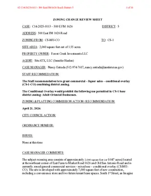
ZONING CHANGE REVIEW SHEET CASE: C14-2025-0113 – 500 E FM 1626 DISTRICT: 5 ADDRESS: 500 East FM 1626 Road ZONING FROM: CS-MU-CO TO: CS-1 SITE AREA: 2,060 square feet out of 1.55 acres PROPERTY OWNER: Forest Creek Investments LLC AGENT: SiteATX, LLC (Jennifer Hanlen) CASE MANAGER: Nancy Estrada (512-974-7617, nancy.estrada@austintexas.gov) STAFF RECOMMEDATION: The Staff recommendation is to grant commercial – liquor sales – conditional overlay (CS-1-CO) combining district zoning. The Conditional Overlay would prohibit the following use permitted in CS-1 base district zoning: Adult-Oriented Businesses. ZONING & PLATTING COMMISSION ACTION / RECOMMENDATION: April 21, 2026: CITY COUNCIL ACTION: ORDINANCE NUMBER: ISSUES: None at this time CASE MANAGER COMMENTS: The subject rezoning area consists of approximately 2,060 square feet (or 0.047 acres) located at the northeast corner of East Farm to Market Road 1626 and Old San Antonio Road and is currently zoned general commercial services – mixed use – conditional overlay (CS-MU- CO). The site is developed with approximately 7,000 square feet of new construction, including a convenience store and two future tenant lease spaces. South 1st Street, an Imagine 02 C14-2025-0113 - 500 East FM 1626 Road; District 51 of 10 C14-2025-0113 Page 2 Austin Corridor, is located less than a quarter mile to the west, while IH-35 is less than one- half mile to the east. East Farm to Market Road 1626 is classified as a Level 3 suburban arterial and functions as a major roadway, while Old San Antonio Road functions as a Level 2 collector roadway. Adjacent land uses include multifamily residences to the north and east, and commercial uses to the east along the South IH-35 frontage road (CS-MU-CO; GR-CO). To the west across Old San Antonio Road are the Austin Fire and Austin-Travis County EMS Station, as well as multifamily residences (P; MF-3-CO). South of the site, across East Farm to Market Road 1626, is a congregate living residential use (MF-2). Properties to the southwest are located outside of the City of Austin’s municipal boundaries and within the City’s two-mile extraterritorial jurisdiction (ETJ). Please refer to Exhibits A (Zoning Map) and A-1 (Aerial View). The Applicant is requesting a footprint rezoning of 2,060 square feet within the commercial/retail center to commercial-liquor sales (CS-1) district zoning. The new development fronts East Farm to Market Road 1626, with vehicular access provided from Old San Antonio Road. Staff is recommending commercial-liquor sales – conditional overlay (CS-1-CO) combining district zoning, as the site is surrounded by (GR) district zoning and (CS) district zoning along the South IH-35 frontage road. The conditional overlay will prohibit adult-oriented businesses. The applicant is in agreement with the staff recommendation. BASIS OF RECOMMENDATION: 1. The proposed zoning should be consistent with the purpose statement of the district sought. The proposed commercial-liquor sales (CS-1) district is intended predominately for commercial and industrial activities of a service nature which typically have operating characteristics or traffic service requirements generally incompatible with residential environments, and specifically includes liquor sales as a permitted use. The Conditional Overlay (CO) combining district may be applied in combination with any base district. The district is intended to provide flexible and adaptable use or site development regulations by requiring standards tailored to individual properties. 2. Zoning changes should promote compatibility with adjacent and nearby land uses. The proposed footprint rezoning is within the newly constructed commercial/retail center. It is surrounded by community commercial (GR) district zoning and general commercial services (CS) base district zoning to the north and east. 02 C14-2025-0113 - 500 East FM 1626 Road; District 52 of 10 C14-2025-0113 Page 3 3. Zoning should promote the policy of locating retail and more intensive zoning near the intersections of arterial roadways or at the intersections of arterials and major collectors. The subject rezoning area is a small footprint within a larger commercial/retail center located along East Farm to Market Road 1626, a level 3 major roadway that intersects with South IH-35 frontage road to the east. South 1st Street, an Imagine Austin Corridor, is located less than a quarter mile to the west and also intersects with East Farm to Market Road 1626. EXISTING ZONING AND LAND USES: ZONING Site CS-MU-CO LAND USES New construction of Convenience store with 2 future tenant spaces North CS-MU-CO; GR-CO Multifamily residences South MF-2; GO-CO East West Multifamily residences; Congregate living CS-MU-CO; CS-CO Multifamily residences; Commercial uses P; MF-3-CO Austin Fire; Austin-Travis County EMS Station; Multifamily residences NEIGHBORHOOD PLANNING AREA: N/A WATERSHED: Onion Creek – Suburban CAPITOL VIEW CORRIDOR: No SCENIC ROADWAY: No SCHOOLS: Austin Independent School District Menchaca Elementary School Paredes Middle School Akins High School COMMUNITY REGISTRY LIST: Austin Independent School District South Austin Neighborhood Alliance (SANA) Friends of Austin Neighborhoods Onion Creek Homeowners Association AREA CASE HISTORIES: NUMBER C14-2016-0021 REQUEST CS-CO; GR-CO; CS-MU-CO to CS-MU-CO CITY COUNCIL Approved as ZAP recommended (06/14/2018) COMMISSION To Grant CS-MU-CO, provided applicant dedicates ROW along FM 1626 Rd and Old San Antonio Road, as outlined in traffic impact analysis (03/06/2018) 02 C14-2025-0113 - 500 East FM 1626 Road; District 53 of 10 C14-2025-0113 RELATED CASES: Page 4 C7A-97-013 – The property was annexed into the full purpose City limits on December 11, 1997 (Ordinance No. 971211-B). ADDITIONAL STAFF COMMENTS: Comprehensive Planning Project Name and Proposed Use: 500 E FM 1626 ROAD. C14-2025-0113. Project: 500 E FM 1626. 1.55 acres from CS-MU-CO to CS-1. Existing: commercial. Proposed: liquor sales. Yes Y Imagine Austin Decision Guidelines Complete Community Measures * Imagine Austin Growth Concept Map: Located within or adjacent to an Imagine Austin Activity Center, Imagine Austin Activity Corridor, or Imagine Austin Job Center as identified the Growth Concept Map. Names of Activity Centers/Activity Corridors/Job Centers *: • 0.24 miles from South First Activity Corridor Mobility and Public Transit *: Located within 0.25 miles of public transit stop and/or light rail station. Mobility and Bike/Ped Access *: Adjoins a public sidewalk, shared path, and/or bike lane. Connectivity, Good and Services, Employment *: Provides or is located within 0.50 miles to goods and services, and/or employment center. Connectivity and Food Access *: Provides or is located within 0.50 miles of a grocery store/farmers market. Connectivity and Education *: Located within 0.50 miles from a public school or university. Y Connectivity and Healthy Living *: Provides or is located within 0.50 miles from a recreation area, park or walking trail. • 0.5 miles to San Leanna Village Park Connectivity and Health *: Provides or is located within 0.50 miles of health facility (ex: hospital, urgent care, doctor’s office, drugstore clinic, and/or specialized outpatient care.) Housing Choice *: Expands the number of units and housing choice that suits a variety of household sizes, incomes, and lifestyle needs of a diverse population (ex: apartments, triplex, granny flat, live/work units, cottage homes, and townhomes) in support of Imagine Austin and the Strategic Housing Blueprint. Housing Affordability *: Provides a minimum of 10% of units for workforce housing (80% MFI or less) and/or fee in lieu for affordable housing. Mixed use *: Provides a mix of residential and non-industrial uses. Culture and Creative Economy *: Provides or is located within 0.50 miles of a cultural resource (ex: library, theater, museum, cultural center). Culture and Historic Preservation: Preserves or enhances a historically and/or culturally significant site. Creative Economy: Expands Austin’s creative economy (ex: live music venue, art studio, film, digital, theater.) 02 C14-2025-0113 - 500 East FM 1626 Road; District 54 of 10 C14-2025-0113 Page 5 Workforce Development, the Economy and Education: Expands the economic base by creating permanent jobs, especially in industries that are currently not represented in a particular area or that promotes a new technology, and/or promotes educational opportunities and workforce development training. Industrial Land: Preserves or enhances industrial land. Y Not located over Edwards Aquifer Contributing Zone or Edwards Aquifer Recharge Zone 3 Number of “Yes’s” Drainage The developer is required to submit a pre- and post-development drainage analysis at the subdivision and site plan stage of the development process. The City’s Land Development Code and Drainage Criteria Manual require that the Applicant demonstrate through engineering analysis that the proposed development will have no identifiable adverse impact on surrounding properties. Environmental The site is not located over the Edwards Aquifer Recharge Zone. The site is in the Onion Creek Watershed of the Colorado River Basin, which is classified as a Suburban Watershed by Chapter 25-8 of the City's Land Development Code. The site is in the Desired Development Zone. Under current watershed regulations, development or redevelopment on this site will be subject to the following impervious cover limits: Development Classification % of Gross Site Area % of Gross Site Area Single-Family (minimum lot size 5750 sq. ft.) Other Single-Family or Duplex Multifamily Commercial 50% 55% 60% 80% with Transfers 60% 60% 70% 90% According to floodplain maps there is no floodplain within or adjacent to the project location. Standard landscaping and tree protection will be required in accordance with LDC 25-2 and 25-8 for all development and/or redevelopment. At this time, site specific information is unavailable regarding vegetation, areas of steep slope, or other environmental features such as bluffs, springs, canyon rimrock, caves, sinkholes, and wetlands. Under current watershed regulations, development or redevelopment requires water quality control with increased capture volume and control of the 2-year storm on site. 02 C14-2025-0113 - 500 East FM 1626 Road; District 55 of 10 C14-2025-0113 Page 6 At this time, no information has been provided as to whether this property has any preexisting approvals that preempt current water quality or Code requirements. PARD – Planning & Design Review Parkland dedication fees may apply to any future site or subdivision applications resulting from this rezoning. As of January 1, 2024, new commercial, non-residential uses are not subject to parkland dedication requirements at the time of site plan and subdivision. Site Plan This use will require Conditional Use Permit approval to sell alcohol, once the rezoning is approved. If no construction is proposed, an A site plan may be filed. If construction is proposed, the site will need to comply with Commercial Design Standards, and a C plan may be filed. Transportation – Engineering Review The Austin Strategic Mobility Plan (ASMP) calls for 120 feet of right-of-way for E FM 1626. It is recommended that 60 feet of right-of-way from the existing centerline should be dedicated for E FM 1626 according to the Transportation Plan with the first subdivision or site plan application. [LDC 25-6-51 and 25-6-55]. The adjacent street characteristics table is provided below: Name ASMP Classification ASMP Required ROW Existing ROW Existing Pavement Sidewalks Bicycle Route Capital Metro (within ¼ mile) Old San Antonio Road Level 2 – Collector E FM 1626 Road Level 3 – Minor or Major Arterial 72’ 85’ 39’ Yes Yes No 120’ 73’ 46’ Yes Yes No Austin Water Utility No comments on zoning change. 02 C14-2025-0113 - 500 East FM 1626 Road; District 56 of 10 C14-2025-0113 Page 7 INDEX OF EXHIBITS AND ATTACHMENTS TO FOLLOW: Exhibit A: Zoning Map Exhibit B: Aerial Photograph Applicant’s Summary Letter 02 C14-2025-0113 - 500 East FM 1626 Road; District 57 of 10 EXHIBIT A 02 C14-2025-0113 - 500 East FM 1626 Road; District 58 of 10 EXHIBIT B !!!!C14-2025-0113C14-03-0053C14-04-0020C14-06-0063C14-03-0053(RCA)C14-2016-0021C14-2010-0174C14-2010-0027C14-2013-0123C14-2008-0220C14-2021-0188EFM1626RDOLDSANANTONIORDFARRAHLNBREZZALNMF-2MF-3-COCS-MU-COPCS-COGR-COCS-MU-COI-RRCS-MU-COLR-CO500 E FM 1626±This product has been produced by Austin Planning for the sole purpose of geographic reference. No warranty is madeby the City of Austin regarding specific accuracy or completeness.ZONING CASE#:LOCATION:SUBJECT AREA:MANAGER:C14-2025-0113 500 E FM 1626 Rd 0.0473 Acres Nancy EstradaCreated: 1/13/2026SUBJECT TRACTZONING BOUNDARY!!!!!PENDING CASECREEK BUFFER1 inch equals 233 '02 C14-2025-0113 - 500 East FM 1626 Road; District 59 of 10 SiteATX, LLC PO Box 161501 Austin Texas 78716 March 9, 2026 To whom it may concern: Our request is to rezone only a portion of the existing commercial building at 500 E 1626, Austin Texas 78748. The portion of the building that is requested to rezone is 2,060 SF. The remaining portion of the building is a convenience store that is under construction. This rezoned space use ill be a liquor store. If you have any additional questions, please feel free to contact me at either 713 825 6271 or via email - siteatx@gmail.com. Thank you, Jennifer Hanlen SiteATX, LLC 02 C14-2025-0113 - 500 East FM 1626 Road; District 510 of 10