06 C14-81-037(RCT) - 3900 W. Howard Lane RCT; District 7 - Staff Report — original pdf
Backup
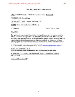
ZONING CHANGE REVIEW SHEET CASE: C14-81-037(RCT) – 3900 W. Howard Lane RCT DISTRICT: 7 ADDRESS: 3900 Howard Lane OWNER/APPLICANT: Otsuka ICU Medical, LLC AGENT: Drenner Group, P.C. (Leah M. Bojo) ZONING: LI REQUEST: AREA: 206.30 acres The applicant is requesting the termination of the public restrictive covenant recorded in 1981 in Volume 7430, Pages 513 - 528 of the Official Public Records of Travis County, Texas, that imposes restrictions on the property for the attached site and landscape plan; on permitted and prohibited uses; on site development standards; on signage; on off street parking regulations; on performance standards and for streets, utilities and other facilities. CASE MANAGER: Sherri Sirwaitis (512-974-3057, sherri.sirwaitis@austintexas.gov) STAFF RECOMMENDATION: Staff recommends the proposed public restrictive covenant termination. ZONING AND PLATTING COMMISSION ACTION / RECOMMENDATION: April 21, 2026 CITY COUNCIL ACTION: 1 06 C14-81-037(RCT) - 3900 W. Howard Lane RCT; District 71 of 27 DEPARTMENT COMMENTS: In this case, the applicant is requesting to terminate a public restrictive covenant that was recorded in 1981 in association with zoning case C14-81-037. The applicant is asking to delete this restrictive covenant to remove restrictions on the property that include conditions on the attached site and landscape plan; permitted and prohibited uses; site development standards; signs; off street parking; performance standards for noise, vibration, glare, smoke and particulate matter, toxic and noxious matter, fire and explosive hazards and liquid or solid wastes and stipulations for streets, utilities and other facilities. Please see Applicant’s Request Letter - Exhibit C and Original Restrictive Covenant – Exhibit D. The staff recommends the applicant’s request to remove the conditions of this public restrictive covenant because the property in question is currently developed with an industrial park that is located at the northwest intersection of West Howard Lane and the North MoPac Expressway South Bound Service Road. New development on the property will be subject to current Code regulations and building requirements. The applicant agrees with the staff’s recommendation. EXISTING ZONING AND LAND USES: Site North South East West ZONING LI PUD, LI PUD ROW, County LI-CO AREA STUDY: N/A WATERSHED: Walnut Creek LAND USES Office/Industrial Robinson Ranch PUD (MXD or TOD Designation) Robinson Ranch PUD (MXD or TOD Designation) North MoPac Frontage Road South Bound Office/Warehouse (Wells Branch Technology Park) CAPITOL VIEW CORRIDOR: N/A HILL COUNTRY ROADWAY: N/A NEIGHBORHOOD ORGANIZATIONS: Friends of Austin Neighborhoods, Homeless Neighborhood Association, Red Line Parkway Initiative AREA CASE HISTORIES: NUMBER C814-04-0066 (Robinson Ranch PUD) REQUEST LI-PDA, DR and I-RR to PUD COMMISSION 6/15/2005: Approved staff rec. for PUD with conditions included in Environmental Board recommendation (9-0). CITY COUNCIL 6/17/2004: Approved PUD zoning on all 3 readings 2 06 C14-81-037(RCT) - 3900 W. Howard Lane RCT; District 72 of 27 C14-00-2036 (Northwest of the intersection of West Howard Lane and McNeil- Merriltown Drive) I-RR to LI-CO 9/26/00: To grant the LI-CO zoning by consent The CO would consist of the recommendations included in the TIA. (Vote: 8-0, Almanza absent). 10/26/2000: Approved LI-CO zoning through Ordinance No. 001026-62 on all 3 readings. RELATED CASES: C14-81-037 – Previous Zoning Case OTHER STAFF COMMENTS: Comprehensive Planning The initiation, termination or amending of a Restrictive Covenant is not under the purview of the policies of the Imagine Austin Comprehensive Plan and therefore an Imagine Austin compliance report has not been provided for this case. Environmental No comments. Fire No comments. Parks and Recreation No comments. Site Plan FYI: All comments regarding the effects of the proposed restrictive covenant termination on subsequent Site Plan Review applications are intended to assist in identifying potential development constraints but do not include all regulations which may affect a specific proposal. Changes to property boundaries and requests for development cannot include all regulatory limitations which may apply to a specific subject to modification or reconsideration if affected by a change in property boundaries or if development is proposed on only a portion of the land proposed for rezoning. These comments are intended to assist in identifying potential development constraints, but do not address the actual restrictions which will apply to a specific development proposal. Austin Development Services offers a variety of pre-application review options to assist in evaluating specific development proposals prior to Site Plan Application. Site plans will be required for any new development except for residential only project with up to 4 units. 3 06 C14-81-037(RCT) - 3900 W. Howard Lane RCT; District 73 of 27 Any new development is subject to Subchapter E. Design Standards and Mixed Use. Additional comments will be made when the site plan is submitted. Transportation No comments. Water Utility No review required. INDEX OF EXHIBITS TO FOLLOW A: Case Map B. Aerial Map C. Applicant’s Request Letter D. Restrictive Covenant 4 06 C14-81-037(RCT) - 3900 W. Howard Lane RCT; District 74 of 27 EXHIBIT A 06 C14-81-037(RCT) - 3900 W. Howard Lane RCT; District 75 of 27 EXHIBIT B !!!!!!!!!!!!!!!!!!!!!!!!!!!!!!!!!!!!!!!!!!!!!!!!!!!!!!!!!!!!!!!!!!!!!!!!!!!!!!!!!!!!!!!!!!!!!!!!!!!!!!!!!!!!!!!!!!!!!!!!!!!!!!!!!!!!!!!!!!!!!!!!!!!!!!!!!!!!!!!!!!!!!!!!!!!!!!!!!!!!!!!!!!!!!!!!!!!!!!!!!!!!!!!!!!!!!!!!!!!!!!!!!!!!!!!!!!!!!!!!!!!!!!!!!!!!!!!!!!!!!!!!!!!!!!!!!!!!!!!!!!!!!!!!!!!!!!!!!!!!!!!!!!!!!!!!!!!!!!!!!!!!!!!!!!!!!!!!!!!!!!!!!!!!!!!!!!!!!!!!!!!!!!!!!!!!!!!!!!!!!!!!!!!!!!!!!!!!!!!!!!!!!!!!!!!!!!!!!!!!!!!!!!!!!!!!!!!!!!!!!!!!!!!!!!!!!!!!!!!!!!!!!(!(!(!(!(!(!(!(!(C14-81-037(RCT)C814-04-0066C814-04-0066C814-04-0066C14-00-2036C14-99-0048C14-00-2112C14-2017-0121C14-05-0035C14-2022-0153C14-92-0109C14-2010-0156C14-2015-0041BURNETRDN MOPAC EXPY SBNMOPACEXPYNBNMOPACEXPYSVRD SBMCNEILDRMCNEILMERRILLTOWNRDWHOWARDLNTANDEMBLVDIDARIDGEDRNMOPACEXPYSVRDNBN MOPAC TOLL TO HOWARD LN RAMPMERRILLTOWNDRNMOPACEXPYTOLLSBORCHIDLNWWELLSBRANCHPKWYWILDIRISLNGARDENIADRDAISYDRASHTONWOODSCIRJOHNSLIGHTDRN MOPAC TOLLTONMOPASBRAMPHOWARD LN TO MOPAC SB RAMPTIERRADRDOTDRBARKLEYDRKIMBERLYNLNWHOWARDLNLIPUDPUDPUDLI-CORRLIGRIPPUDGOCSGRRRPUDCSMF-3-COGORRGRGR-MUGR-MUGR-COPUDCS-COCS-1RRCS-1MF-3-CO3900 W Howard Lane±This product has been produced by Austin Planning for the sole purpose of geographic reference. No warranty is madeby the City of Austin regarding specific accuracy or completeness.ZONING CASE#:LOCATION:SUBJECT AREA:MANAGER:C14-81-037(RCT)3900 W Howard Ln170.14 AcresSherri SirwaitisCreated: 2/3/2026SUBJECT TRACTZONING BOUNDARY!!!!!PENDING CASECREEK BUFFER1 inch equals 817 '06 C14-81-037(RCT) - 3900 W. Howard Lane RCT; District 76 of 27 EXHIBIT C December 3, 2025 Via Electronic Delivery Ms. Lauren Middleton-Pratt Planning Department City of Austin 1000 E 11th Street, Suite 200 Austin, TX 78702 Re: 3900 Howard Lane – Restrictive Covenant Termination application for that certain Restrictive Covenant recorded in Volume 7430, Pages 513 - 528 of the Official Public Records of Travis County, Texas (the “Restrictive Covenant”) located on that certain tract of land out of the Francisco Garcia Survey No. 60, and 206.30 acres, Travis County, Texas (the “Property”). Dear Ms. Middleton-Pratt: As representatives of the owner of the Property, we respectfully submit the enclosed Restrictive Covenant Termination application package. The TCAD IDs for the Property is 0267110101 with the following legal description: Special Warranty Deed 2025045001: Being that certain tract of land out of the Francisco Garcia Survey No. 60, Travis County, Texas, being that certain 206.30 acre tract conveyed by Deed recorded in Volume 6809, Page 2125, Deed Records, Travis County, Texas; Save and Except the following tracts conveyed by Deed recorded in Volume 11375, Page 1432, Real Property Records, Instrument Nos. 2000182911 and 2000183905 and Instrument No. 2003141698, Official Public Records, Travis County, Texas. A Restrictive Covenant was recorded in 1981 in Volume 7430, Pages 513 - 528 of the Official Public Records of Travis County, Texas, including the following: 1. No improvements shall be constructed or maintained on the above-described property except those indicated on the site and landscape plan heretofore approved by the City Council, a copy of which is attached hereto and made a part hereof marked Exhibit "B". 2. The site plan as finally approved and attached hereto may be adjusted or altered subsequently when such modification is required by provisions of City Ordinances or State statutes or is the result of official action by any quasi-judicial body having jurisdiction affecting the use of the subject property or when the adjustments or alterations are designed to provide a more appropriate development of the site and are determined by City Manager of the City of Austin, or his designee, to be reasonably consistent with the expressed covenants contained herein. (A) Uses: 3. 1) No residential use shall be permitted within the Property except for watchmen or custodian in conjunction with the uses proposed. 2) No outdoor storage or display of material or products shall be permitted. 3) Uses permitted shall include the following uses, and all uses incidental or appurtenant thereto: a. Offices or other financial and related facilities; b. Business services or any other commercial use; 06 C14-81-037(RCT) - 3900 W. Howard Lane RCT; District 77 of 27 Storage and warehousing; c. d. Wholesale distribution; e. Manufacturing or processing where conducted as follows: i. ii. iii. All operations shall be within a fully enclosed building; All activities shall be conducted in such a way as to comply with the applicable performance standards; and Articles produced or processed shall be likely to generate truck traffic. (B) Height and set back provisions: 1) Building Height: Forty-Five feet (45’), but when set back from all property lines, buildings may exceed this height by one foot (1’) for each one foot (1’) of additional set back. This height limitation does not apply to signs or water towers. 2) Set Back: All buildings shall be set back at least two hundred feet (200’) from F.M. Highway 1325 and Howard Lane and one hundred feet (100’) from Merilltown-McNeil Road as shown on site plan. 3) Coverage: Not more than thirty-five percent (35%) of the area described herein shall be covered by buildings. (C) Signs: 1) Advertising signs shall not be located adjacent to residential development, except for those products produced on site. 2) Flashing lights shall not be used on any signs designed to be viewed beyond the premises described herein. (D) Offstreet Parking: 1) Administration offices and related facilities: One (1) automobile parking space for each three hundred (300) square feet of floor area shall be provided. 2) Manufacturing and warehousing and other uses: One (1) automobile parking space for each five hundred (500) square feet of floor area shall be provided. 3) Offstreet loading: As shown on site plan (E) Performance Standards: 1) General: No land or structure within the Property shall be used or occupied in any manner so as to create any dangerous, injurious, noxious, or otherwise objectionable noise, smoke, dust or other form of air pollution, liquid or solid refuse or waste, or other substance, condition or element in such a manner or in such amount as to adversely affect any use or premise within the vicinity; the foregoing are hereinafter referred to as “dangerous or objectionable elements”. 2) Locations where determinations are to be made for enforcement standards: a. Noise, vibration and glare: At the location of the use creating the same at a point on the source property line which has the highest readings, and at any other points where the existence of such elements may be more apparent. b. Smoke, toxic and noxious matter: At the place of emission into the atmosphere. 3) Noise: At the points of measurement, the maximum sound pressure level radiated by any use or facility (other than transportation facilities or temporary construction work) shall not exceed the decibel limit values for the octave bands given in Table I. The sound pressure level shall be measured with a Sound Level Meter and associated Octave Bank Analyzer conforming to standards prescribed by the American Standards Association. (American Standard South Level Meters for Measurement of Noise and Other Sounds, 06 C14-81-037(RCT) - 3900 W. Howard Lane RCT; District 78 of 27 224.3-1944, American Standards Association, Inc., New York, N.Y. and American Standard Specification for an Octave Band Filter Set for the Analysis of Noise and Other Sounds, 224.10-1953, American Standards Association, Inc., New York, N.Y., or latest approved revisions thereof on the date of adoption of this Ordinance shall be used.) a. Table I Frequency Ranges Containing Standard Octave Bands in Cycles per Second 20 to 75 75 to 150 150 to 300 300 to 600 600 to 1,200 1,200 to 2,400 2,400 to 4,800 Above 4,800 Octave Band Sound Pressure Level in Decibels re 0.0002 dyne/square centimeter 72 67 59 56 53 50 44 38 Between the hours of 10:00 P.M. and 6:00 A.M., the permissible sound levels shall be three decibels less than shown above. Measurements shall be made, less background noises from other sources, using the flat network and the slow position of the sound level meter. 4) Vibration: At the points of measurements, earthborne vibrations from any operation or plant shall not exceed the limits set forth in Column I below, for the area in which located, unless the point of measurements is located on a property line which is also the boundary line of a residential area or within eighty feet (80’) of a residential area boundary line which is located within a street right-of-way, in which case the limits set forth in Column II below shall apply. Frequency Cycles per Second 0 to 10 10 to 20 20 to 30 30 to 40 40 and over Table II Column I* Displacement (inches) 0.0010 0.0008 0.0005 0.0004 0.0003 Column II* Displacement (inches) 0.0004 0.0002 0.0001 0.0001 0.0001 *Steady State-vibrations, for the purpose of this instrument, which are continuous or more frequent than sixty pulses per minute. Impact vibration, those less frequent than sixty pulses per minute, shall not cause more than twice the displacement stipulated. 5) Glare: Any operation or activity producing intense glare shall be performed in such a manner as not to create a nuisance or hazard across any property line. Direction illumination from any source of light or direct welding flash shall be screened from properties adjoining the Property and reflected light from these sources shall not exceed 0.4 foot candles across the source property line. 6) Smoke and Particulate Matter: Smoke emitted from any vent, stack, chimney, skylight, window, building opening, or combustion process shall not exceed an opacity of 06 C14-81-037(RCT) - 3900 W. Howard Lane RCT; District 79 of 27 Ringelmann No.1 as observed on the Ringelmann Chart. However, once during any 6-hour period, Ringelmann No. 2 will be permitted but not for longer than five minutes. The emission of particulate matter from all sources shall not exceed one pound per acre of property within the boundary of any plat site under consideration during any one hour. Dust coarser than 44 microns shall be limited to 0.05 pounds per acre of property during any one hour. Open industrial operations involving dust-producing or dust-causing equipment of operations such as sandblasting, paint spraying, and similar operations, shall be so conducted that such dusts do not cross lot lines in concentrations exceeding one million particles per cubic foot when measured at ground level or habitable elevation, at or beyond the lot line, whichever is more restrictive. 7) Toxic and Noxious Matter: In no case shall the concentration of toxic or noxious matter be released across source lot lines which will exceed ten percent (10%) of the concentration (exposure) considered as the threshold limit for an industrial worker. Reference is made to the most recent publication, at the time of adoption of the Ordinance, of “Threshold Limit Values”, adopted by the Texas State Board of Health in accordance with authority granted in Article 4418d of the Revised Civil Statutes of Texas. 8) Fire and Explosive Hazards: Activities involving the storage and utilization of materials or products which decompose by detonation are permitted only when specifically approved by the City of Austin Fire Department. Such materials shall include, but are not limited to, all primary explosives such as lead azide, lead styphnate, fulminates and tetracene; all high explosives such as TNT, HMX, PETN and Picric acid; propellants and components thereof such as nitrocellulose, black powder, boron hydrides, hydrazine and its derivatives; pyrotechnics and fireworks such as magnesium powder, potassium chlorate, and potassium nitrate; blasting explosives such as dynamite and nitroglycerin; unstable organic compounds such as acetylides, tetozoies, and ozonides; strong oxidizing agents such as perchloric acid, perchlorates, chlorates and hydrogen peroxide in concentrations greater than 35%; and nuclear fuels, fissionable materials and products, and reactor elements such as Uranium 235 and Plutonium 239. Explosives shall be stored, utilized and manufactured in accordance with applicable local, state and federal codes. All applications for uses involving fire and explosive hazards may be referred to the office of the City of Austin Fire Department for approval. Such approval shall indicate compliance with all applicable fire codes and ordinances of the City of Austin and shall be indicated on the application within ten (10) days from the date such application was made in the office of the Building Inspector. 9) Liquid or Solid Wastes: No discharge shall be made into a public sewer, any private sewage disposal system, stream or into the ground unless in accordance with the standards approved by the City of Austin, which, because of the nature or temperature of the material discharged, can contaminate any water supply, interfere with the bacterial processes in sewage treatment, or otherwise cause the emission of dangerous or offensive elements. (F) Streets, Utilities and Other Facilities: 1) Streets and Utilities: Easements for utilities and streets shall be granted in accordance with site plan attached hereto at such time as it is determined by the City of Austin that they are needed. Provision shall be made by the City of Austin for water and sewage and garbage disposal in accordance with its usual rates, procedures and policies as necessary for the property development of the area. 06 C14-81-037(RCT) - 3900 W. Howard Lane RCT; District 710 of 27 2) Access: Abbott will open and maintain only the street accesses shown on Exhibit “B” approximate location shown thereon, and no other. Provided, however, that should additional access be deemed advisable, approval of the City Manager of the City of Austin shall be obtained in addition to such other authorities as may be required by law. An Amendment of Restrictive Covenant was recorded in Volume 10872, Page 226 of the Official Public Records of Travis County, Texas: 1. Now Therefore, the Acting City Manager for the City is authorized to execute, on behalf of the City, this document which amends the document of record in Volume 7430, at Pages 513-522, of the Deed Records of Travis County, Texas, by deleting the following restriction: (3) (D) Offstreet Parking: 2. Manufacturing and warehousing and other uses: One (1) automobile parking space for each five hundred (500 square feet of floor area shall be provided; And substituting in its place the following restriction: which shall reflect the City of Austin’s current parking requirements as set forth in the Land Development Code: (3) (D) Offstreet Parking: 2. Manufacturing and warehousing and other related use: One (1) automobile parking space for each one thousand (1000) square feet of gross floor area shall be provided. As you can see, most of these items are now included in City Land Development Code or Technical Codes, are no longer relevant, or can be included in the LI-PDA zoning application that accompanies this request. Please let me know if you or your team members require additional information or have any questions at this time. Thank you for your time and attention to this project. Sincerely, Leah M. Bojo 06 C14-81-037(RCT) - 3900 W. Howard Lane RCT; District 711 of 27 EXHIBIT D 06 C14-81-037(RCT) - 3900 W. Howard Lane RCT; District 712 of 27 06 C14-81-037(RCT) - 3900 W. Howard Lane RCT; District 713 of 27 06 C14-81-037(RCT) - 3900 W. Howard Lane RCT; District 714 of 27 06 C14-81-037(RCT) - 3900 W. Howard Lane RCT; District 715 of 27 06 C14-81-037(RCT) - 3900 W. Howard Lane RCT; District 716 of 27 06 C14-81-037(RCT) - 3900 W. Howard Lane RCT; District 717 of 27 06 C14-81-037(RCT) - 3900 W. Howard Lane RCT; District 718 of 27 06 C14-81-037(RCT) - 3900 W. Howard Lane RCT; District 719 of 27 06 C14-81-037(RCT) - 3900 W. Howard Lane RCT; District 720 of 27 06 C14-81-037(RCT) - 3900 W. Howard Lane RCT; District 721 of 27 06 C14-81-037(RCT) - 3900 W. Howard Lane RCT; District 722 of 27 06 C14-81-037(RCT) - 3900 W. Howard Lane RCT; District 723 of 27 06 C14-81-037(RCT) - 3900 W. Howard Lane RCT; District 724 of 27 06 C14-81-037(RCT) - 3900 W. Howard Lane RCT; District 725 of 27 06 C14-81-037(RCT) - 3900 W. Howard Lane RCT; District 726 of 27 06 C14-81-037(RCT) - 3900 W. Howard Lane RCT; District 727 of 27