06 C8J-2021-0141.0A and SP-2021-0446D - 8020 Parmer Lane SH 130 NW Part 3.pdf — original pdf
Backup
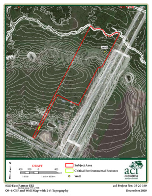
Well d x m . y h p a r g o p o T t f - 2 h t i w p a M l l e W d n a F E C _ 4 - 9 Q \ I R E _ 1 _ k s a t \ s p a m \ s i g \ I R E r e m r a P 0 2 0 8 4 7 1 - 0 2 - 5 3 \ s r e d l o F t c e j o r P \ P : CEF-1 ³ This map is intended for planning purposes only. All map data should be considered preliminary. All boundaries and designations are subject to confirmation. 400 200 DRAFT 0 400 Feet Subject Area Critical Environmental Features 1:4,800 1 inch = 400 feet Well 8020 East Parmer ERI Q9-4: CEF and Well Map with 2-ft Topography aci Project No.: 35-20-160 December 2020 Backup page 115 of 188162 of 2356 d x m . ) Z Q W C ( e n o Z y t i l a u Q r e t a W l a c i t i r C n i t s u A f o y t i C _ 5 - 9 Q \ I R E _ 1 _ k s a t \ s p a m \ s i g \ I R E r e m r a P 0 2 0 8 4 7 1 - 0 2 - 5 3 \ s r e d l o F t c e j o r P \ P : ³ This map is intended for planning purposes only. All map data should be considered preliminary. All boundaries and designations are subject to confirmation. 400 200 DRAFT 0 1:4,800 1 inch = 400 feet 400 Feet Subject Area Critical Water Quality Zone 8020 East Parmer ERI Q9-5: City of Austin Critical Water Quality Zone (CWQZ) aci Project No.: 35-20-174 December 2020 Backup page 116 of 188163 of 2356 d x m . s e n o Z d r a z a H d o o l F A M E F _ 6 - 9 Q \ I R E _ 1 _ k s a t \ s p a m \ s i g \ I R E r e m r a P 0 2 0 8 4 7 1 - 0 2 - 5 3 \ s r e d l o F t c e j o r P \ P : ³ 1% Annual Chance Flood Hazard Regulatory Floodway Special Floodway Area of Undetermined Flood Hazard 0.2% Annual Chance Flood Hazard This map is intended for planning purposes only. All map data should be considered preliminary. All boundaries and designations are subject to confirmation. Future Conditions 1% Annual Chance Flood Hazard Area with Reduced Risk Due to Levee 400 200 DRAFT 0 1:4,800 1 inch = 400 feet 400 Feet Subject Area 8020 East Parmer ERI Q9-6: FEMA Flood Hazard Zones aci Project No.: 35-20-174 December 2020 Backup page 117 of 188164 of 2356 Question 10 Attachments City of Austin ERI 8020 East Parmer ERI Tract 16 December 2020 aci Project No.: 35-20-174 austin • denver Backup page 118 of 188165 of 2356 Q10-1. Surface Soils According to the United States Department of Agriculture (USDA) Natural Resource Conservation Service (NRCS) Web Soil Survey (2020), four soil map units occur within the subject area: Soil Type Group Thickness (inches) Ferris-Heiden complex, 8 to 20 percent slopes, severely eroded (FhF3) Heiden clay, 3 to 5 percent slopes, eroded (HeC2) Houston Black clay, 1 to 3 percent slopes (HnB) Tinn clay, 0 to 1 percent slopes, frequently flooded D D D D 36 to 60 inches 40 to 65 inches <80 inches <80 inches Reference Section: (USDA NRCS) United States Department of Agriculture, Natural Resource Conservation Service. 2020. Web Soil Survey. Available at: http://websoilsurvey.nrcs.usda.gov/. Accessed on: November 25, 2020. Q10-2. Wells According to the Texas Water Development Board Well Viewer (TWDB 2020), one monitoring well is located in the northeastern portion to the subject area. Reference Section: (TWDB 2020) Texas Water Development Board. 2020. Well Viewer. Available at: https://www3.twdb.texas.gov/apps/WaterDataInteractive/GroundwaterDataVie wer. Accessed on: December 1, 2020. City of Austin ERI 8020 East Parmer ERI Tract 17 December 2020 aci Project No.: 35-20-174 austin • denver Backup page 119 of 188166 of 2356 Q10-3. Functional Assessment of Floodplain Health City of Austin ERI 8020 East Parmer ERI Tract 18 December 2020 aci Project No.: 35-20-174 austin • denver Backup page 120 of 188167 of 2356 8020 EAST PARMER ERI TRAVIS COUNTY, TEXAS Project: 8020 East Parmer ERI Tract Functional Assessment of Floodplain Health Date: December 4, 2020 To: Cityline Companies, LLC From: aci consulting | Stephen Meyer Subject: Supporting Documentation for the City of Austin Functional Assessment of Floodplain Health of the Zone 1 Floodplain Health and Zone 2 Critical Water Quality Zone On December 1, 2020, aci consulting conducted a City of Austin (COA) Functional Assessment of Floodplain Health (FAFH) for the Zone 1 – Floodplain Health and Zone 2 – Critical Water Quality Zone (CWQZ) within the 8020 East Parmer ERI Tract in Travis County, Texas. There were three transects within the Critical Water Quality Zone (CWQZ) (Zone 2), that were evaluated for the FAFH: T-1, T-2, and T-3 (Attachment A). There was one transect within the FEMA Floodplain Health Zone (Zone 1) that was evaluated for the FAFH: T-4 (Attachment B). The FAFH was conducted according to Appendix X of the COA Environmental Criteria Manual (ECM) along all four transects. As defined in Appendix X of the ECM for FAFH’s, a typical transect is 100 meters. For this study, each transect was examined at three 100m2 plots: at 5 meters, 50 meters, and 95 meters. The results were then averaged to represent each transect. Lastly, all three transects in Zone 2 were averaged to quantify the area as a whole. The Zone 1 and Zone 2 scores and the assessed condition for each transect are shown below in Table 1 and Table 2, respectively. austin • denver aci consulting a division of aci group, LLC Austin (512) 347.9000 • Denver (720) 440.5320 www.aci-consulting.net Backup page 121 of 188168 of 2356 Zone 2 Transects T-1, T-2, and T-3 were positioned within the CWQZ; therefore, the methods and scoring for Zone 2: Critical Water Quality Zone were used during the field investigations. Attachment A shows the placement of the transects within the subject area. Attachment C contains the field investigation findings of the FAFH in Zone 2: Critical Water Quality Zone. Transect 1 was located in the CWQZ associated with the unnamed creek and Transect 2 and 3 were located in CWQZ associated with Harris Branch. The findings for T-1 are depicted in Table 1 and the findings for T-2 and T-3 are in Table 2. Overall, the FAFH score for T-1 was 14 points, indicating that the current assessed conditions are “Fair”. The overall average FAFH score for T-2 and T-3 was 20.5 points, indicating that the current assessed conditions are “Good”. Table 1: Zone 2 Scores and Assessed Conditions for each Transect Transect Zone 1 Score Assessed Condition T-1 14 Fair Table 2: Zone 2 Scores and Assessed Conditions for each Transect Transect T-2 T-3 Average Zone 1 Score 19 22 20.5 Assessed Condition Good Good Good Zone 1 Transect T-4 was positioned within the FEMA Floodplain; therefore, the methods and scoring for Zone 1: Floodplain Health were used during the field investigation. Attachment B shows the placement of the transect within the subject. Attachment D contains the field investigation findings of the FAFH in Zone 1: Floodplain Health. Transect 4 was located in the FEMA Floodplain associated with Harris Branch. The findings for T-4 are depicted in Table 3. Overall, the average FAFH score was 15 points, indicating that the current assessed conditions for both zones are “Good”. 8020 East Parmer ERI Tract Functional Assessment of Floodplain Health aci Project No: 35-20-174 December 2020 austin • denver Backup page 122 of 188169 of 2356 Table 3: Zone 1 Scores and Assessed Conditions for each Transect Transect Zone 1 Score Assessed Condition T-4 Good 15 8020 East Parmer ERI Tract Functional Assessment of Floodplain Health aci Project No: 35-20-174 December 2020 austin • denver Backup page 123 of 188170 of 2356 ATTACHMENT A ZONE 2 TRANSECT LOCATIONS 8020 East Parmer ERI Tract Functional Assessment of Floodplain Health aci Project No: 35-20-174 December 2020 austin • denver Backup page 124 of 188171 of 2356 d x m . 2 e n o Z _ Z Q W C e h t f o t n e m s s e s s A l a n o i t c n u F _ A t n e m h c a t t A \ H F A F _ 2 _ k s a t \ s p a m \ s i g \ I R E r e m r a P 0 2 0 8 4 7 1 - 0 2 - 5 3 \ s r e d l o F t c e j o r P \ P : T-2 T-3 T-1 ³ This map is intended for planning purposes only. All map data should be considered preliminary. All boundaries and designations are subject to confirmation. 400 200 DRAFT 0 400 Feet 1:4,800 1 inch = 400 feet Subject Area Critical Water Quality Zone NHD Flowlines Transects 8020 East Parmer ERI Attachment A: Functional Assessment of the CWQZ - Zone 2 aci Project No.: 35-20-174 December 2020 Backup page 125 of 188172 of 2356 ATTACHMENT B ZONE 1 TRANSECT LOCATIONS 8020 East Parmer ERI Tract Functional Assessment of Floodplain Health aci Project No: 35-20-174 December 2020 austin • denver Backup page 126 of 188173 of 2356 d x m . 1 e n o Z _ h t l a e H n i a l p d o o l F e h t f o t n e m s s e s s A l a n o i t c n u F _ B t n e m h c a t t A \ H F A F _ 2 _ k s a t \ s p a m \ s i g \ I R E r e m r a P 0 2 0 8 4 7 1 - 0 2 - 5 3 \ s r e d l o F t c e j o r P \ P : T-4 1% Annual Chance Flood Hazard Regulatory Floodway Special Floodway Area of Undetermined Flood Hazard 0.2% Annual Chance Flood Hazard This map is intended for planning purposes only. All map data should be considered preliminary. All boundaries and designations are subject to confirmation. Future Conditions 1% Annual Chance Flood Hazard Area with Reduced Risk Due to Levee ³ 400 200 DRAFT 0 400 Feet 1:4,800 1 inch = 400 feet Subject Area Transect NHD Flowlines Critical Water Quality Zone 8020 East Parmer ERI aci Project No.: 35-20-174 Attachment B: Functional Assessment of the Floodplain Health - Zone 1 December 2020 Backup page 127 of 188174 of 2356 ATTACHMENT C FUNCTIONAL ASSESSMENT OF FLOODPLAIN HEALTH FORMS ZONE 2 – CRITICAL WATER QUALITY ZONE 8020 East Parmer ERI Tract Functional Assessment of Floodplain Health aci Project No: 35-20-174 December 2020 austin • denver Backup page 128 of 188175 of 2356 Scoring: Zone 2 – Critical Water Quality Zone 8020 East Parmer ERI Site/Project Name: Transect Number: T-1 12/01/2020 10:13 AM Date: Staff (if applicable): Time: GN & MF Parameter Excellent (4) Good (3) Fair (2) Poor (1) Score GFGF Gap Frequency A visual assessment of the number of gaps in vegetation. 0 - 20% of riparian area has visual gaps in vegetation 20% - 40% of riparian area has visual gaps in vegetation 40 - 60% of riparian area has visual gaps in vegetation > 60% of riparian area has visual gaps in vegetation 7 or more pieces of large woody debris 5 - 6 pieces of large woody debris 3 - 4 pieces of large woody debris 2 or less pieces of large woody debris 0 - 200 pounds per square inch 201 - 400 pounds per square inch 401 - 600 pounds per square inch > 600 pounds per square inch > 65% canopy; or > 50% canopy and > 50% understory 51 - 65% canopy; or 0 - 50% canopy and > 40% understory Tree Demography An assessment of the age class distribution of all canopy tree species. Canopy tree species are present in all 4 age classes Canopy tree species are present in 3 of 4 age classes 31 - 50% canopy; or 0 - 30% canopy and > 30% understory Canopy tree species are present in 2 of 4 age classes 0 - 30% canopy; or 0 - 15% canopy and 0 - 30% understory Canopy tree species are present in only 1 age class or no trees > 65% of trees are FAC+ or greater 50 - 65% of trees are FAC+ or greater 25 - 49% of trees are FAC+ or greater < 25% of trees are FAC+ or greater Large Woody Debris An evaluation of the amount of large woody debris. Soil Compaction An assessment of the bulk density of the soil. Structural Diversity An evaluation of the canopy and understory vegetation. Wetland Tree Status Percent of total trees that are defined as FAC+ or greater with respect to wetland status. Riparian Zone Width A measure of the width of the undisturbed riparian zone. > 18 meters or > 75% of the CWQZ 12 - 18 meters or 50 - 75% of the CWQZ 6 - 12 meters or 25 - 49% of the CWQZ < 6 meters or < 25% of the CWQZ Zone 2 Score: 14 4 1 4 2 1 1 1 Assessed Condition (Circle One) Excellent: 25 - 28 Good: 18 - 24 Fair: 11 - 17 Fair: 11 - 17 Poor: 7 - 10 Backup page 129 of 188176 of 2356 Site/Project Name: Transect Number: Gap Frequency Number of 1 meter gaps: Percent of Transect: Soil Compaction Structural Diversity Tree Demography Field Sheet: Zone 2 – Critical Water Quality Zone Date: Time: Staff (if applicable): % Large Woody Debris Number of Large Woody Debris Pieces: Plot 1 (5 meters) Plot 2 (50 meters) Plot 3 (95 meters) #1: psi #2: psi #3: psi #1: psi #2: psi #3: psi #1: psi #2: psi #3: psi Average for Plot 1: psi Average for Plot 2: psi Average for Plot 3: psi Average for All Sample Plots: _____________psi Plot 1 (5 meters) Plot 2 (50 meters) Plot 3 (95 meters) Canopy: % Understory: % Canopy: % Understory: % Canopy: % Understory: % Average for All Sample Plots: Canopy: % Understory: % Plot 1 (5 meters) Plot 2 (50 meters) Plot 3 (95 meters) Number of Age Classes: Number of Age Classes: Number of Age Classes: Average for All Sample Plots: Backup page 130 of 188177 of 2356 Site/Project Name: Transect Number: Wetland Tree Status Riparian Zone Width Field Sheet: Zone 2 – Critical Water Quality Zone Date: Time: Staff (if applicable): Plot 1 (5 meters) Plot 2 (50 meters) Plot 3 (95 meters) Number of FAC+ or Greater Trees: Total Number of Trees: Percent FAC+ or Greater: Number of FAC+ or Greater Trees: Total Number of Trees: Percent FAC+ or Greater: Number of FAC+ or Greater Trees: Total Number of Trees: Percent FAC+ or Greater: % % % Average for All Sample Plots: _____________% Measurement 1 (5 meters) Measurement 2 (50 meters) Measurement 3 (95 meters) Riparian Zone Width: m Riparian Zone Width: m Riparian Zone Width: m Average for All Measurements: m Backup page 131 of 188178 of 2356 Scoring: Zone 2 – Critical Water Quality Zone 8020 East Parmer ERI Site/Project Name: Transect Number: T-2 12/01/2020 12:49 PM Date: Staff (if applicable): Time: GN & MF Parameter Excellent (4) Good (3) Fair (2) Poor (1) Score GFGF Gap Frequency A visual assessment of the number of gaps in vegetation. 0 - 20% of riparian area has visual gaps in vegetation 20% - 40% of riparian area has visual gaps in vegetation 40 - 60% of riparian area has visual gaps in vegetation > 60% of riparian area has visual gaps in vegetation 7 or more pieces of large woody debris 5 - 6 pieces of large woody debris 3 - 4 pieces of large woody debris 2 or less pieces of large woody debris 0 - 200 pounds per square inch 201 - 400 pounds per square inch 401 - 600 pounds per square inch > 600 pounds per square inch > 65% canopy; or > 50% canopy and > 50% understory 51 - 65% canopy; or 0 - 50% canopy and > 40% understory Tree Demography An assessment of the age class distribution of all canopy tree species. Canopy tree species are present in all 4 age classes Canopy tree species are present in 3 of 4 age classes 31 - 50% canopy; or 0 - 30% canopy and > 30% understory Canopy tree species are present in 2 of 4 age classes 0 - 30% canopy; or 0 - 15% canopy and 0 - 30% understory Canopy tree species are present in only 1 age class or no trees > 65% of trees are FAC+ or greater 50 - 65% of trees are FAC+ or greater 25 - 49% of trees are FAC+ or greater < 25% of trees are FAC+ or greater Large Woody Debris An evaluation of the amount of large woody debris. Soil Compaction An assessment of the bulk density of the soil. Structural Diversity An evaluation of the canopy and understory vegetation. Wetland Tree Status Percent of total trees that are defined as FAC+ or greater with respect to wetland status. Riparian Zone Width A measure of the width of the undisturbed riparian zone. > 18 meters or > 75% of the CWQZ 12 - 18 meters or 50 - 75% of the CWQZ 6 - 12 meters or 25 - 49% of the CWQZ < 6 meters or < 25% of the CWQZ Zone 2 Score: 19 4 2 4 4 2 2 1 Assessed Condition (Circle One) Excellent: 25 - 28 Good: 18 - 24 Good: 18 - 24 Fair: 11 - 17 Poor: 7 - 10 Backup page 132 of 188179 of 2356 Site/Project Name: Transect Number: Gap Frequency Number of 1 meter gaps: Percent of Transect: Soil Compaction Structural Diversity Tree Demography Field Sheet: Zone 2 – Critical Water Quality Zone Date: Time: Staff (if applicable): % Large Woody Debris Number of Large Woody Debris Pieces: Plot 1 (5 meters) Plot 2 (50 meters) Plot 3 (95 meters) #1: psi #2: psi #3: psi #1: psi #2: psi #3: psi #1: psi #2: psi #3: psi Average for Plot 1: psi Average for Plot 2: psi Average for Plot 3: psi Average for All Sample Plots: _____________psi Plot 1 (5 meters) Plot 2 (50 meters) Plot 3 (95 meters) Canopy: % Understory: % Canopy: % Understory: % Canopy: % Understory: % Average for All Sample Plots: Canopy: % Understory: % Plot 1 (5 meters) Plot 2 (50 meters) Plot 3 (95 meters) Number of Age Classes: Number of Age Classes: Number of Age Classes: Average for All Sample Plots: Backup page 133 of 188180 of 2356 Site/Project Name: Transect Number: Wetland Tree Status Riparian Zone Width Field Sheet: Zone 2 – Critical Water Quality Zone Date: Time: Staff (if applicable): Plot 1 (5 meters) Plot 2 (50 meters) Plot 3 (95 meters) Number of FAC+ or Greater Trees: Total Number of Trees: Percent FAC+ or Greater: Number of FAC+ or Greater Trees: Total Number of Trees: Percent FAC+ or Greater: Number of FAC+ or Greater Trees: Total Number of Trees: Percent FAC+ or Greater: % % % Average for All Sample Plots: _____________% Measurement 1 (5 meters) Measurement 2 (50 meters) Measurement 3 (95 meters) Riparian Zone Width: m Riparian Zone Width: m Riparian Zone Width: m Average for All Measurements: m Backup page 134 of 188181 of 2356 ATTACHMENT D FUNCTIONAL ASSESSMENT OF FLOODPLAIN HEALTH FORMS ZONE 1 – FLOODPLAIN HEALTH 8020 East Parmer ERI Tract Functional Assessment of Floodplain Health aci Project No: 35-20-174 December 2020 austin • denver Backup page 135 of 188182 of 2356 Scoring: Zone 1 – Floodplain Health 8020 East Parmer ERI Site/Project Name: Transect Number: T-4 12/1/2020 Date: 12:08 PM5 Time: Staff (if applicable): GN & MF Parameter Excellent (4) Good (3) Fair (2) Poor (1) Score Gap Frequency A visual assessment of the number of gaps in vegetation. 0 - 20% of area has visual gaps in vegetation 20% - 40% of area has visual gaps in vegetation 40 - 60% of area has visual gaps in vegetation > 60% of area has visual gaps in vegetation Large Woody Debris An evaluation of the amount of large woody debris. Soil Compaction An assessment of the bulk density of the soil. Structural Diversity An evaluation of the canopy and understory vegetation. 7 or more pieces of large woody debris 5 - 6 pieces of large woody debris 3 - 4 pieces of large woody debris 2 or less pieces of large woody debris 0 - 200 pounds per square inch 201 - 400 pounds per square inch 401 - 600 pounds per square inch > 600 pounds per square inch > 65% canopy; or > 50% canopy and > 50% understory 51 - 65% canopy; or 0 - 50% canopy and > 40% understory 31 - 50% canopy; or 0 - 30% canopy and > 30% understory 0 - 30% canopy; or 0 - 15% canopy and 0 - 30% understory Tree Demography An assessment of the age class distribution of all canopy tree species. Canopy tree species are present in all 4 age classes Canopy tree species are present in 3 of 4 age classes Canopy tree species are present in 2 of 4 age classes Canopy tree species are present in only 1 age class or no trees 4 1 4 4 2 Zone 1 Score: 15 Assessed Condition (Circle One) Excellent: 18 - 20 Good: 13 - 17 Fair: 8 - 12 Poor: 5 - 7 Backup page 136 of 188183 of 2356 Field Sheet: Zone 1 – Floodplain Health Site/Project Name: 8020 East Parmer ERI Transect Number: T-4 Gap Frequency 0 Number of 1 meter gaps: 0 Percent of Transect: Soil Compaction % 12/1/2020 Date: 12:08 PM Time: Staff (if applicable): GN & MF Large Woody Debris 0 Number of Large Woody Debris Pieces: Plot 1 (5 meters) Plot 2 (50 meters) Plot 3 (95 meters) 120 #1: 160 psi #2: psi #3: 140 psi 190 #1: 200 psi #2: psi #3: psi 140 #1: 150 180 psi #2: psi #3: psi 210 Average for Plot 1: 140 psi Average for Plot 2: 176.66 psi Average for Plot 3: psi Average for All Sample Plots: _____________psi 165.55 Structural Diversity Tree Demography Plot 1 (5 meters) Plot 2 (50 meters) Plot 3 (95 meters) Canopy: % Understory: % 100 80 Canopy: 100 % Understory: % Canopy: 50 % Understory: 100 % 100 Average for All Sample Plots: Canopy: % Understory: % 76.66 100 Plot 1 (5 meters) Plot 2 (50 meters) Plot 3 (95 meters) Number of Age Classes: 3 1 Number of Age Classes: 2 Number of Age Classes: Average for All Sample Plots: 2 Backup page 137 of 188184 of 2356 EXHIBIT 11 – PRELIMINARY BRIDGE PLANS Backup page 138 of 188185 of 2356 DRAFT THIS DOCUMENT IS RELEASED FOR THE PURPOSE OF INTERIM REVIEW UNDER THE AUTHORITY OF RYAN C. LAURENT, P.E. LIC. #131995 05/02/2022 IT SHALL NOT BE USED FOR CONSTRUCTION, BIDDING, OR PERMIT PURPOSES. 1 : 3 20'-0" BAS-C PROP RETAINING WALL CEF BUFFER 13.00' WINGWALL EXISTING CRITICAL ENVIRONMENTAL FEATURE CEF BUFFER PROP RETAINING WALL BRIDGE LIGHTING STA 1+53.37 BEGIN BRIDGE FACE OF BACKWALL ABUTMENT NO. 1 ℄ PRIVATE DRIVEWAY STA 1+49.37 EL = 555.26' ℄ BENT NO. 2 ℄ PRIVATE DRIVEWAY STA 2+44.37 S T R E A M F L O W " 0 - ' 1 T E S F F O " 0 - ' 1 L I A R ℄ BENT NO. 3 ℄ PRIVATE DRIVEWAY STA 3+74.37 BRIDGE LIGHTING STA 2+96.71 ℄ BENT NO. 4 ℄ PRIVATE DRIVEWAY STA 4+61.87 BRIDGE LIGHTING STA 4+46.71 E " 4 2 . 8 3 ' 5 2 ° 2 6 S S T N E B L L A P Y T ( ) S T N E M T U B A D N A END BRIDGE FACE OF BACKWALL ABUTMENT NO. 5 ℄ PRIVATE DRIVEWAY STA 5+49.37 EL = 557.99' PROP ROW PROP RETAINING WALL 1+00 CSAB (OPT. 2) ℄ GIRDER NO. 1 3:1 2+00 3+00 ℄ PRIVATE DRIVEWAY & PGL 4+00 N 27° 34' 21.76" E NOM FACE OF SSTR RAIL 5+00 3:1 CSAB (OPT. 2) 6+00 SEJ-M(4") ℄ GIRDER NO. 5 SEJ-M(4") " 0 - ' 0 2 " 0 - ' 0 2 L L A R E V O " 0 - ' 0 4 Y A W D A O R " 0 - ' 8 3 " 0 - ' 2 1 E N A L " 0 - ' 2 1 I N A D E M " 0 - ' 2 1 E N A L % 0 . 2 % 0 . 2 BRIDGE LIGHTING STA 2+21.68 " 0 - ' 1 L I A R " 0 - ' 1 T E S F F O CONST/ CONTROL JT CONST/ CONTROL JT NOM FACE OF SSTR RAIL BRIDGE LIGHTING STA 3+70.37 PROP ROW BRIDGE LIGHTING STA 5+22.18 EXISTING CRITICAL ENVIRONMENTAL FEATURE PLAN OVERALL LENGTH OF TYPE SSTR RAIL = 431'-0" (RT) OVERALL LENGTH OF TYPE SSTR RAIL = 400'-0" (LT) OVERALL LENGTH OF BRIDGE = 400'-0" 305'-0" Tx54 I-GIRDER UNIT (130.00'-87.50'-87.50') 640 630 620 610 600 590 580 570 560 550 540 530 520 510 500 490 480 95'-0" Tx34 I-GIRDER UNIT (95.00') BEGIN BRIDGE FACE OF BACKWALL ABUTMENT NO. 1 ℄ PRIVATE DRIVEWAY STA 1+49.37 EL = 555.26' 0 0 . 5 7 + 1 : S C V E 9 7 . 5 5 5 : E C V E 7 3 . 4 9 + 1 : S C V B . 3 0 6 5 5 : E C V B 1.23% D PROP RET. WALL 4 - 36" DIA DR SH x XX' 7 3 . 4 4 + 2 : S C V E . 6 4 6 5 5 : E C V E D " 0 - ' 8 " H " 2 VERTICAL CURVE DATA HIGH POINT ELEV: 2+44.37 HIGH POINT STA: 556.46' PVI STA: 2+19.37 PVI ELEV: 556.34' AD: 0.73% K: 68.30 50.00' VC 9 2 . 5 5 5 4 7 . 0 4 5 2+00 LOW CHORD ELEV = 551.11' 1 VERTICAL CURVE DATA HIGH POINT ELEV: 1+75.00 HIGH POINT STA: 555.79' PVI STA: 1+25.00 PVI ELEV: 555.18' AD: 6.74% K: 14.83 100.00' VC 5 1 . 2 5 5 0 0 . 1 4 5 1+00 END BRIDGE FACE OF BACKWALL ABUTMENT NO. 5 ℄ PRIVATE DRIVEWAY STA 5+49.37 EL = 557.99' PGL TOP OF DECK TOP OF SSTR RAIL 0.50% D D D D HW(25) = 546.25' HW(100) = 548.39' 3 - 36" DIA DR SH x XX' 3 - 36" DIA DR SH x XX' " 0 - ' 8 " H " 3 " 0 - ' 8 " H " 4 PROP RET. WALL EXIST GROUND AT ℄ PRIVATE DRIVEWAY 4 - 36" DIA DR SH x XX' 3 - 36" DIA DR SH x XX' 5 5 0 . 6 5 5 9 9 . 8 3 5 3+00 ELEVATION 5 5 . 6 5 5 9 2 . 1 4 5 4+00 5 0 . 7 5 5 9 9 . 3 4 5 5+00 SEJ-M(4") 1 : 3 20'-0" BAS-C PROP RETAINING WALL 18.00' WINGWALL 4 2 . 9 7 + 5 : S C V B 4 1 . 8 5 5 : E C V B NOTES: 1. 2. 3. 4. 5. 6. 7. 8. DESIGNED ACCORDING TO AASHTO LRFD BRIDGE DESIGN SPECIFICATIONS, 8TH EDITION (2017) AND CURRENT INTERIMS. SEE BORING LOG SHEET FOR BORING LOG INFORMATION. ALL DIMENSIONS ARE HORIZONTAL AND MUST BE CORRECTED FOR GRADE AND CROSS SLOPE. THE "H" VALUES SHOWN ARE ESTIMATED COLUMN HEIGHTS AND ARE FOR BIDDING PURPOSES ONLY. THE CONTRACTOR IS RESPONSIBLE FOR CALCULATING THE ACTUAL COLUMN HEIGHTS BASED ON FIELD CONDITIONS. EXTEND DRILLED SHAFTS TO THE LENGTH SHOWN OR LONGER AS NECESSARY TO OBTAIN A MINIMUM OF TWO (2) DRILLED SHAFT DIAMETERS INTO THE BEARING STRATA. BEARING CONDITIONS: D = DOWEL BLANK = NO DOWEL SSTR RAIL OPTIONAL SIDE SLOT DRAINS ARE NOT PERMITTED. MEDIAN ON BRIDGE IS TO BE STRIPED ONLY. A RAISED MEDIAN IS NOT PERMITTED. HYDRAULIC DATA UPSTREAM BRIDGE FACE PROPOSED: HW(25) = 546.25' V(25) = 2.08 FPS Q (25) = 3,060 CFS HW(100) = 548.39' V (100) = 2.74 FPS Q (100) = 4,570 CFS 640 630 620 610 600 590 580 570 560 550 540 530 520 510 500 490 480 © / W N 0 3 1 H S R E M R A P 0 2 0 8 S A X E T , I N T S U A , E N A L R E M R A P T S A E 0 2 0 8 T U O Y A L E G D R B I VERTICAL CURVE DATA HIGH POINT ELEV: 6+79.24 HIGH POINT STA: 560.21' PVI STA: 6+29.24 PVI ELEV: 558.39' AD: 3.14% K: 31.85 100.00' VC 5 5 . 7 5 5 0 5 . 9 4 5 6+00 RD-A S-01 SP-2021-XXXX Backup page 139 of 188186 of 2356 ℄ PRIVATE DRIVEWAY ℄ PRIVATE DRIVEWAY 20'-0" 20'-0" 20'-0" 20'-0" 1'-0" RAIL 1'-0" RAIL 1'-0" RAIL 1'-0" RAIL NOMINAL FACE OF SSTR RAIL NOMINAL FACE OF SSTR RAIL NOMINAL FACE OF SSTR RAIL NOMINAL FACE OF SSTR RAIL 1'-0" OFFSET 12'-0" LANE 12'-0" MEDIAN 12'-0" LANE 1'-0" OFFSET 1'-0" OFFSET 12'-0" LANE 12'-0" MEDIAN 12'-0" LANE 1'-0" OFFSET ℄ GIRDER NO. 1 ℄ GIRDER NO. 5 ℄ GIRDER NO. 1 ℄ GIRDER NO. 5 3'-0" 3'-0" 3'-0" 3'-0" 40'-0" OVERALL 38'-0" ROADWAY 2.0% 2.0% " 2 1 8 B A L S PGL 4 SPA AT 8'-6" = 34'-0" Tx54 I-GIRDERS TYPICAL SECTION SPANS 2-4 40'-0" OVERALL 38'-0" ROADWAY 2.0% 2.0% " 2 1 8 B A L S PGL 4 SPA AT 8'-6" = 34'-0" Tx34 I-GIRDERS TYPICAL SECTION SPAN 1 © / W N 0 3 1 H S R E M R A P 0 2 0 8 S A X E T , I N T S U A , E N A L R E M R A P T S A E 0 2 0 8 I S N O T C E S L A C P Y T E G D R B I I S-02 DRAFT THIS DOCUMENT IS RELEASED FOR THE PURPOSE OF INTERIM REVIEW UNDER THE AUTHORITY OF RYAN C. LAURENT, P.E. LIC. #131995 05/02/2022 IT SHALL NOT BE USED FOR CONSTRUCTION, BIDDING, OR PERMIT PURPOSES. SP-2021-XXXX Backup page 140 of 188187 of 2356 EXHIBIT 12 – WETLAND MITIGATION SHEETS Backup page 141 of 188188 of 2356 Wetland 1: Area within site boundary: 2529 sf Area disturbed: 2529 sf Wetland 2: Area within site boundary: 314 sf Area disturbed: 202 sf 10' Inlet 10' Inlet Current CEF Setback Extended CEF Boundary Extended CEF Boundary Current CEF Setback 15' Inlet 10' Inlet 1 0 ' I n e l t PUMP ROOM T T Current CEF Setback Extended CEF Boundary l t e n I ' 5 1 Wetland 3: Area within site boundary: 299 sf Area disturbed: 0 sf Extended CEF Boundary Current CEF Setback Extended CEF Boundary 15' Inlet 15' Inlet R 1601 Rio Grande Street Suite 450 Austin, Texas 78701 T 512.770.4503 hitchcockdesigngroup.com 15' Inlet 07.16.2021 PROJECT 8020 Parmer/ SH130 NW 8020 East Parmer Lane Austin, Texas CONSULTANTS Civil Engineer Pape Dawson 10800 North Mopac Expressway Building 3, Suite 200 Austin, Texas 78759 t l e n I ' 5 1 l t e n I ' 5 1 COMPLETENESS CHECK JULY 16, 2021 REVISIONS No Date Issue CHECKED BY DTR DRAWN BY JTH SHEET TITLE Wetland Mitigation SCALE IN FEET 1" = 50' g w d . t e S t i m r e P n o i t a g i t i M d n a l t e W \ t i m r e P 0 0 i \ s c h p a r G 9 0 \ e n a L r e m r a P i l - r a u d o M Z \ n g s e D G T S \ s t c e o r P j \ : S CALCULATIONS CEF Buffer Area Disturbed (Outside Wetland) - 2.05 acres Wetland Area Disturbed - 0.06 acres Total Site Area Disturbed - 2.11 acres LEGEND Wetland Note: In the CEF mitigation and floodplain restoration area, the top 12 inches of topsoil shall be used onsite and reseeded with appropriate 604S.6, native grasses and forbs, and provide temporary irrigation in compliance with ECM P1. This is a condition of the environmental variances granted for the grading in the floodplain and fill greater than 4'. Disturbed Wetland Area - 0.06 acres Disturbed Area Outside Wetland - 2.05 acres Extended CEF Area - 2.11 acres CEF Current CEF Setback Extend CEF Boundary SITE PLAN RELEASE FILE NUMBER__________________APPLICATION DATE_______________ SP-2021-XXXX JULY 16, 2021 APPROVED BY COMMISSION ON_______________UNDER SECTION_______ OF CHAPTER__________OF THE CITY OF AUSTIN CODE. 25-5 EXPIRATION DATE (25-5-81,LDC)__________CASE MANAGER__________________ XXXX PROJECT EXPIRATION DATE (ORD.#970905-A)__________DWPZ______DDZ______ Know what's below. Call before you dig. WARNING: CONTRACTOR IS TO VERIFY PRESENCE AND EXACT LOCATION OF ALL UTILITIES PRIOR TO CONSTRUCTION. __________________________________________________________________________ 0' 25' 50' 150' Development Services Department RELEASED FOR GENERAL COMPLIANCE:_____________ZONING_____________ ETJ Rev. 1____________________________Correction 1_____________________________ Rev. 2____________________________Correction 2_____________________________ Rev. 3____________________________Correction 3_____________________________ Final plat must be recorded by the Project Expiration Date, if applicable. Subsequent Site Plans which do not comply with the Code current at the time of filing, and all required Building Permits and/or a notice of construction (if a building permit is not required), must also be approved prior to the Project Expiration Date. NORTH SHEET NUMBER WM1.01 C 2018 Hitchcock Design Group Backup page 142 of 188189 of 2356 10' Inlet 10' Inlet Raingarden See Sheet WM 1.03 Reference only, not in mitigation calculation Concrete Trail CAA - 5 CIL - 9 JNI - 4 LAU - 3 MGL - 3 POC -4 SYO - 4 15' Inlet 10' Inlet Vegetated Water Quality Pond See Sheet WM 1.03, Reference only, not in mitigation calculation T T 1 0 ' I n e l t PUMP ROOM PROVIDE FOUR (4) ROWS OF ALTERNATING SWITCH GRASS (PANICUM VIRGATUM) AND EASTERN GAMAGRASS (TRIPSACUM DACTYLOIDES) Boardwalk CAA -5 CIL - 8 JNI - 6 LAU - 4 MGL - 2 POC -5 SYO - 5 POD - 5 TDI - 8 CEC - 6 LIB - 7 ELA - 50 JEF - 50 LCS - 50 LOC - 50 NLU - 50 POD - 6 TDI - 10 CEC - 7 LIB - 9 POD1 - 81 TDI1 - 81 CEC1 - 81 LIB1 - 82 AGW - 11 BMA - 14 LFC - 14 MTR - 10 QVI - 17 RHA - 10 UAM - 14 UIL - 28 Grass Bottom Detention Pond PROVIDE FOUR (4) ROWS OF ALTERNATING SWITCH GRASS (PANICUM VIRGATUM) AND EASTERN GAMAGRASS (TRIPSACUM DACTYLOIDES) POD1 - 81 TDI1 - 81 CEC1 - 81 LIB1 - 82 Concrete Trail 15' Inlet R 1601 Rio Grande Street Suite 450 Austin, Texas 78701 T 512.770.4503 hitchcockdesigngroup.com 07.16.2021 PROJECT 8020 Parmer/ SH130 NW 8020 East Parmer Lane Austin, Texas CONSULTANTS Civil Engineer Pape Dawson 10800 North Mopac Expressway Building 3, Suite 200 Austin, Texas 78759 LEGEND Mitigation Revegetation - High Water Use Tree & Shrub Mix - 0.18 acres Mitigation Revegetation - Moderate Water Use Tree & Shrub Mix - 0.07 acres Mitigation Revegetation - Light Water Use Tree & Shrub Mix - 0.17 acres Mitigation Revegetation - Aquatic Plant Mix - 0.12 acres Total Mitigation Revegetation Area: 0.54 acres g w d . t e S t i m r e P n o i t a g i t i M d n a l t e W \ t i m r e P 0 0 i \ s c h p a r G 9 0 \ e n a L r e m r a P l i - r a u d o M Z \ n g s e D G T S \ s t c e o r P j \ : S Non Mitigation Revegetation - Riparian Area - 1-gallon native woody saplings - 0.35 acres Non Mitigation Revegetation - Upland Species Seed Mix, Full Sun Area - 5.37 acres Non Mitigation Revegetation - Solid Sod - 5.20 acres COMPLETENESS CHECK JULY 16, 2021 REVISIONS No Date Issue CHECKED BY DTR DRAWN BY JTH SHEET TITLE Wetland Revegetation & Calculation SCALE IN FEET 1" = 50' Note: In the CEF mitigation and floodplain restoration area, the top 12 inches of topsoil shall be used onsite and reseeded with appropriate 604S.6, native grasses and forbs, and provide temporary irrigation in compliance with ECM P1. This is a condition of the environmental variances granted for the grading in the floodplain and fill greater than 4'. SITE PLAN RELEASE FILE NUMBER__________________APPLICATION DATE_______________ SP-2021-XXXX JULY 16, 2021 APPROVED BY COMMISSION ON_______________UNDER SECTION_______ OF CHAPTER__________OF THE CITY OF AUSTIN CODE. 25-5 EXPIRATION DATE (25-5-81,LDC)__________CASE MANAGER__________________ XXXX PROJECT EXPIRATION DATE (ORD.#970905-A)__________DWPZ______DDZ______ Know what's below. Call before you dig. WARNING: CONTRACTOR IS TO VERIFY PRESENCE AND EXACT LOCATION OF ALL UTILITIES PRIOR TO CONSTRUCTION. __________________________________________________________________________ 0' 25' 50' 150' Development Services Department RELEASED FOR GENERAL COMPLIANCE:_____________ZONING_____________ ETJ Rev. 1____________________________Correction 1_____________________________ Rev. 2____________________________Correction 2_____________________________ Rev. 3____________________________Correction 3_____________________________ Final plat must be recorded by the Project Expiration Date, if applicable. Subsequent Site Plans which do not comply with the Code current at the time of filing, and all required Building Permits and/or a notice of construction (if a building permit is not required), must also be approved prior to the Project Expiration Date. NORTH SHEET NUMBER WM1.02 C 2018 Hitchcock Design Group Backup page 143 of 188190 of 2356 10' Inlet R T T 10' Inlet SGI 26 MAR 5 MCA 31 MLI 26 PVG 139 CLF 12 SGI 29 HMA 25 PVI 14 CLF 12 MCA 31 MLI 26 PVG 136 MAR 10 SMI 4 MAR 7 SGI 29 HMA 25 CCG 14 MAR 15 MCA 33 SMI 11 MLI 28 MAR 15 CCG 14 HMA 25 SGI 28 PLANT SCHEDULE WQP & RAINGARDEN SHRUBS BOTANICAL / COMMON NAME CONTAINER HEIGHT CLF CCG HMA MAR MCA MLI PVI SMI SFW SGI TLE CVI CVS CLA PVG Chasmanthium latifolium Northern Sea Oats Conoclinium greggii Gregg`s Mistflower Helianthus maximiliani Maximilian Sunflower Malvaviscus drummondii Turk`s Cap Muhlenbergia capillaris Gulf Muhly Muhlenbergia lindheimeri `Big` Big Muhly Physostegia virginiana Obedient Plant Sabal minor Dwarf Palmetto Salvia farinacea Mealy Sage Salvia greggii Autumn Sage Tagetes lemmonii Copper Canyon Daisy Callirhoe involucrata Purple Poppymallow Calyptocarpus vialis Horseherb Coreopsis lanceolata Lanceleaf Tickseed Panicum virgatum Switch Grass 5 gal 5 gal 5 Gal. 5 gal 3 Gal 5 gal 5 Gal. 5 gal 5 Gal. 5 gal 5 Gal. 1 gal 1 gal 1 gal 1 gal 10-12" QTY 24 28 75 52 181 158 44 15 170 142 84 12" o.c. 238 sf 12" o.c. 590 sf 18" o.c. 191 sf 15" o.c. 1,565 sf GROUND COVERS BOTANICAL / COMMON NAME CONTAINER SPACING 1 VEGETATED WATER QUALITY POND 1" = 20'-0" 2 RAINGARDEN PLANTING 1" = 20'-0" 1601 Rio Grande Street Suite 450 Austin, Texas 78701 T 512.770.4503 hitchcockdesigngroup.com 07.16.2021 PROJECT 8020 Parmer/ SH130 NW 8020 East Parmer Lane Austin, Texas CONSULTANTS Civil Engineer Pape Dawson 10800 North Mopac Expressway Building 3, Suite 200 Austin, Texas 78759 COMPLETENESS CHECK JULY 16, 2021 REVISIONS No Date Issue CHECKED BY DTR DRAWN BY JTH SHEET TITLE Pond & Raingarden Planting Plan SCALE IN FEET 1" = 50' SITE PLAN RELEASE FILE NUMBER__________________APPLICATION DATE_______________ SP-2021-XXXX JULY 16, 2021 APPROVED BY COMMISSION ON_______________UNDER SECTION_______ OF CHAPTER__________OF THE CITY OF AUSTIN CODE. 25-5 EXPIRATION DATE (25-5-81,LDC)__________CASE MANAGER__________________ XXXX PROJECT EXPIRATION DATE (ORD.#970905-A)__________DWPZ______DDZ______ Know what's below. Call before you dig. WARNING: CONTRACTOR IS TO VERIFY PRESENCE AND EXACT LOCATION OF ALL UTILITIES PRIOR TO CONSTRUCTION. __________________________________________________________________________ 0' 25' 50' 150' Development Services Department RELEASED FOR GENERAL COMPLIANCE:_____________ZONING_____________ ETJ Rev. 1____________________________Correction 1_____________________________ Rev. 2____________________________Correction 2_____________________________ Rev. 3____________________________Correction 3_____________________________ Final plat must be recorded by the Project Expiration Date, if applicable. Subsequent Site Plans which do not comply with the Code current at the time of filing, and all required Building Permits and/or a notice of construction (if a building permit is not required), must also be approved prior to the Project Expiration Date. NORTH SHEET NUMBER WM1.03 C 2018 Hitchcock Design Group PVG 268 MLI 39 TLE 42 CVS 307 SFW 85 PVG 271 MLI 39 TLE 42 CVS 307 SFW 85 PVG 230 SGI 30 MCA 34 PVI 30 CLA 89 CVI 247 MCA 52 g w d . t e S t i m r e P n o i t a g i t i M d n a l t e W \ t i m r e P 0 0 i \ s c h p a r G 9 0 \ e n a L r e m r a P l i - r a u d o M Z \ n g s e D G T S \ s t c e o r P j \ : S Backup page 144 of 188191 of 2356 EXHIBIT 13 – FLOODPLAIN MODIFICATION SHEET Backup page 145 of 188192 of 2356 Wetland 1: Area within site boundary: 2529 sf Area disturbed: 2529 sf Wetland 2: Area within site boundary: 314 sf Area disturbed: 202 sf 10' Inlet 10' Inlet Floodplain Modification Boundary Current CEF Setback Extended CEF Boundary Zone 2 Zone 1 Floodplain Modification Boundary Floodplain Modification Boundary Extended CEF Boundary Current CEF Setback 15' Inlet 10' Inlet 1 0 ' I n e l t PUMP ROOM T T Current CEF Setback Floodplain Modification Boundary Extended CEF Boundary l t e n I ' 5 1 Wetland 3: Area within site boundary: 299 sf Area disturbed: 0 sf Extended CEF Boundary Current CEF Setback Extended CEF Boundary 15' Inlet 15' Inlet 15' Inlet t l e n I ' 5 1 l t e n I ' 5 1 R 1601 Rio Grande Street Suite 450 Austin, Texas 78701 T 512.770.4503 hitchcockdesigngroup.com 07.16.2021 PROJECT 8020 Parmer/ SH130 NW 8020 East Parmer Lane Austin, Texas CONSULTANTS Civil Engineer Pape Dawson 10800 North Mopac Expressway Building 3, Suite 200 Austin, Texas 78759 COMPLETENESS CHECK JULY 16, 2021 REVISIONS No Date Issue CHECKED BY DTR DRAWN BY JTH SHEET TITLE Floodplain Modification SCALE IN FEET 1" = 50' Note: In the CEF mitigation and floodplain restoration area, the top 12 inches of topsoil shall be used onsite and reseeded with appropriate 604S.6, native grasses and forbs, and provide temporary irrigation in compliance with ECM P1. This is a condition of the environmental variances granted for the grading in the floodplain and fill greater than 4'. SITE PLAN RELEASE FILE NUMBER__________________APPLICATION DATE_______________ SP-2021-XXXX JULY 16, 2021 APPROVED BY COMMISSION ON_______________UNDER SECTION_______ OF CHAPTER__________OF THE CITY OF AUSTIN CODE. 25-5 EXPIRATION DATE (25-5-81,LDC)__________CASE MANAGER__________________ XXXX PROJECT EXPIRATION DATE (ORD.#970905-A)__________DWPZ______DDZ______ Know what's below. Call before you dig. WARNING: CONTRACTOR IS TO VERIFY PRESENCE AND EXACT LOCATION OF ALL UTILITIES PRIOR TO CONSTRUCTION. __________________________________________________________________________ 0' 25' 50' 150' Development Services Department RELEASED FOR GENERAL COMPLIANCE:_____________ZONING_____________ ETJ Rev. 1____________________________Correction 1_____________________________ Rev. 2____________________________Correction 2_____________________________ Rev. 3____________________________Correction 3_____________________________ Final plat must be recorded by the Project Expiration Date, if applicable. Subsequent Site Plans which do not comply with the Code current at the time of filing, and all required Building Permits and/or a notice of construction (if a building permit is not required), must also be approved prior to the Project Expiration Date. NORTH SHEET NUMBER FM1.04 C 2018 Hitchcock Design Group g w d . t e S t i m r e P n o i t a g i t i M d n a l t e W \ t i m r e P 0 0 i \ s c h p a r G 9 0 \ e n a L r e m r a P i l - r a u d o M Z \ n g s e D G T S \ s t c e o r P j \ : S LEGEND Floodplain Modification Boundary, Area: 2.69 ac Zone 1 (Floodplain outside the CWQZ) CEF Current CEF Setback Zone 2 (Floodplain within the CWQZ) Extend CEF Boundary Backup page 146 of 188193 of 2356 EXHIBIT 14 – PRELIMINARY POND PLANS Backup page 147 of 188194 of 2356 SEDIMENTATION/FILTRATION POND MAINTENANCE PLAN: WATER QUALITY POND SUMMARY: NOTES: B B A LEGEND A E T OF TEX A S S T A SHELLY MITCHELL 103662 P R L O F E S I C E N S SIONAL R E E D E NE N G I S A L L A D I H T R O W T R O F I N O T S U O H I O I N O T N A N A S I N I T S U A 10801 N MOPAC EXPY, BLDG 3, STE 200 I AUSTIN, TX 78759 I 512.454.8711 1 0 8 8 2 0 0 1 # N O I T A R T S I G E R M R I F S L P B T I 0 7 4 # N O I T A R T S I G E R M R I F E P B T N A L P D N O P / W N 0 3 1 H S R E M R A P 0 2 0 8 S A X E T , I N T S U A SITE PLAN RELEASE FILE NUMBER C8J-2021-0141.0APA APPLICATION DATE ____AUGUST 20, 2021_______ APPROVED BY COMMISSION UNDER SECTION OF 112 CHAPTER 25-5 OF THE CITY OF AUSTIN CODE. EXPIRATION DATE (25-5-81, LDC) CASE MANAGER XXXX PROJECT EXPIRATION DATE ORD. #970905-A) DWPZ DDZ DEVELOPMENT SERVICES DEPARTMENT RELEASED FOR GENERAL COMPLIANCE: ZONING ETJ Rev. 1 Correction 1 Rev. 2 Correction 2 Rev. 3 Correction 3 Final plat must be recorded by the Project Expiration Date, if applicable. Subsequent Site Plans Plans which do not comply with the Code current at the time of filing, and all required Building Permits and/or a notice of construction (if a building permit is not required), must also be approved prior to the Project Expiration Date. 16 of 21 C8J-2021-0141.0APA SHELLY MITCHELLPESGISIONALNE103662ROFEENRESTATOFSTEXALICENSED05/20/2022Backup page 148 of 188195 of 2356 E T OF TEX A S S T A SHELLY MITCHELL 103662 P R L O F E S I C E N S SIONAL R E E D E NE N G I S A L L A D I H T R O W T R O F I N O T S U O H I O I N O T N A N A S I N I T S U A 10801 N MOPAC EXPY, BLDG 3, STE 200 I AUSTIN, TX 78759 I 512.454.8711 1 0 8 8 2 0 0 1 # N O I T A R T S I G E R M R I F S L P B T I 0 7 4 # N O I T A R T S I G E R M R I F E P B T S L I A T E D D N O P / W N 0 3 1 H S R E M R A P 0 2 0 8 S A X E T , I N T S U A DETENTION POND 1 OUTFALL SITE PLAN RELEASE FILE NUMBER C8J-2021-0141.0APA APPLICATION DATE ____AUGUST 20, 2021_______ APPROVED BY COMMISSION UNDER SECTION OF 112 CHAPTER 25-5 OF THE CITY OF AUSTIN CODE. EXPIRATION DATE (25-5-81, LDC) CASE MANAGER XXXX PROJECT EXPIRATION DATE ORD. #970905-A) DWPZ DDZ DEVELOPMENT SERVICES DEPARTMENT RELEASED FOR GENERAL COMPLIANCE: ZONING ETJ Rev. 1 Correction 1 Rev. 2 Correction 2 Rev. 3 Correction 3 Final plat must be recorded by the Project Expiration Date, if applicable. Subsequent Site Plans Plans which do not comply with the Code current at the time of filing, and all required Building Permits and/or a notice of construction (if a building permit is not required), must also be approved prior to the Project Expiration Date. 17 of 21 C8J-2021-0141.0APA SECTION A-A SECTION B-B FILTRATION POND OUTLET SECTION 05/19/2022Backup page 149 of 188196 of 2356 EXHIBIT 15 – RIPARIAN ZONE MITIGATION FUND Q7 FORM Backup page 150 of 188197 of 2356 Appendix Q-7: Riparian Zone Mitigation Section 25-8-364 of the Land Development Code (Floodplain Modification) allows for mitigation where restoration of floodplain health is infeasible, in accordance with Section 1.7 of this manual. The mitigation requirement may be satisfied by: (1) Paying into the Water Supply Mitigation Fund (see Option 1 Worksheet); (2) Transferring mitigation land to the City of Austin or placing restrictions on mitigation land through a conservation easement (see Option 2 Worksheet); or (3) A combination of these mitigation methods (see Option 1 and Option 2 Worksheets). Section 25-8-261 of the Land Development Code (Critical Water Quality Zone Development) allows for payment into the Riparian Zone Mitigation Fund as mitigation for a utility line in urban and suburban watersheds located parallel to and within the Critical Water Quality Zone (CWQZ) if on-site restoration is infeasible, in accordance with Section 1.5 of this manual. If land is dedicated or restricted, it must be approved by the City and the applicant must file in the deed records a restrictive covenant, approved by the city attorney, that runs with the transferring tract and describes the restrictions on development and vegetation management. In addition, the applicant shall pay all costs of restricting the mitigation land or transferring the mitigation land to the City, including the costs of: (a) an environmental site assessment without any recommendations for further clean-up, certified to the City not earlier than the 120th day before the closing date transferring land to the City; (b) a category 1(a) land title survey, certified to the City and the title company not earlier than the 120th day before the closing date transferring land to the City; (c) a title commitment with copies of all Schedule B and C documents, and an owner's title policy; (d) a fee simple deed, or, for a restriction, a restrictive covenant approved as to form by the city attorney; (e) taxes prorated to the closing date; (f) recording fees; and charges or fees collected by the title company. The mitigation land must also have acceptable operating & maintenance (O&M) conditions, as approved by the proposed land manager. The presence of an outstanding environmental feature or attribute may allow the mitigation land to deviate slightly from the previous criteria where desirable and appropriate, pending approval from the Director of the Watershed Protection Department. If the applicant is placing restrictions on the mitigation land, the conservation easement must be approved and recorded prior to the issuance of a development permit. Backup page 151 of 188198 of 2356 OPTION 1 WORKSHEET CALCULATION FOR PAYMENT INTO THE RIPARIAN ZONE MITIGATION FUND A. OWNER/AGENT INFORMATION: Name: Company: Telephone: B. PROJECT INFORMATION: Name: Location or Address: Permit Number: Case Manager: C. MITIGATION REQUIRED Fax: Area Modified within the 100-Year Floodplain: (ac.) Area Disturbed by a Parallel Utility within the CWQZ: Ratio Applied (circle): The ratio for an area modified within the 100-Year Floodplain is determined by ECM 1.7.6. The ratio is 1:1 for a parallel utility within the CWQZ. Multiply the acres modified or disturbed by the ratio to determine the mitigation required. (ac.) 8:1 4:1 3:1 2:1 6:1 1:1 Mitigation Required: D. PAYMENT CALCULATION: Mitigation Land Provided by Applicant: Mitigation land provided by the applicant must be approved by the Director of the Watershed Protection Department and the Proposed Land Manager (Option 2 Worksheet). A project disturbing the CWQZ with a parallel utility does not have the option to provide mitigation land. Mitigation by Payment (ac.) = Mitigation Required - Mitigation Land Provided by Applicant (ac.) (ac.) Mitigation by Payment: Base Fee: Annual Adjustment Factor: Adjusted Fee: Total Fee: $15,000 per acre 7% beginning October 1, 2008 (ac.) $ Mitigation by Payment (ac.) x Adjusted Fee = $ Backup page 152 of 188199 of 2356 Backup page 153 of 188200 of 2356 EXHIBIT 16 – FUNCTIONAL ASSESSMENT OF FLOODPLAIN HEALTH Backup page 154 of 188201 of 2356 ±14.34-Acre Parmer MF Functional Assessment of Floodplain Health July 28, 2021 Mr. Warren Hayes Z Modular 227 West Monroe Street., Suite 2600 Chicago, IL 60606 Re: Dear Mr. Hayes, Pape-Dawson Engineers, Inc. conducted a functional assessment of floodplain health (functional assessment) for the ±14.34-acre Parmer MF project site located in Travis County, Texas. The purpose of the functional assessment is to assess the functional characteristics of the Critical Water Quality Zone (CWQZ), the floodplain outside the CWQZ, and the active channel, in order to determine the health of the floodplain. Based on Pape-Dawson’s functional assessment, the area of proposed floodplain modification resulted in a Zone 2 score of fifteen, which is considered “fair” conditions for floodplain health by the City of Austin (COA). The transect used for the functional assessment was a representative transect, as the area of proposed floodplain modification had unpermitted work take place, thus altering the assessment process. The transect used to assess floodplain health was determined in coordination with the COA and their respective methodologies. The conclusions presented in this report represent the professional opinion of Pape-Dawson Engineers and are limited to the conditions observed at the project site at the time and date of the field investigation. If you have questions or require additional information, please do not hesitate to contact me at (512) 454- 8711 at your earliest convenience. Sincerely, Pape-Dawson Engineers, Inc. Valerie Collins, AICP Associate Vice President H:\Projects\512\49\00\ENV\Parmer-MF_FunctionalAssessment\Draft\210715_ParmerMF_CoverLetter.docx Backup page 155 of 188202 of 2356 ±14.34-ACRE PARMER MF Functional Assessment of Floodplain Health July 2021 Backup page 156 of 188203 of 2356 ±14.34-ACRE PARMER MF Functional Assessment of Floodplain Health July 2021 Backup page 157 of 188204 of 2356 ±14.34-ACRE PARMER MF Functional Assessment of Floodplain Health TABLE OF CONTENTS INTRODUCTION ............................................................................................................................................. 1 METHODS ...................................................................................................................................................... 1 Desktop Review ........................................................................................................................................ 1 Field Methods ........................................................................................................................................... 2 RESULTS ........................................................................................................................................................ 2 DISCUSSION ................................................................................................................................................... 3 CONCLUSION ................................................................................................................................................. 4 REFERENCES .................................................................................................................................................. 5 EXHIBITS Exhibit 1 – Location Map Exhibit 2 – Site Map Exhibit 3 – Historical Aerial Photograph Map (2015) Exhibit 4 – Historical Aerial Photograph Map (2005) Exhibit 5 – Historical Aerial Photograph Map (1995) Exhibit 6 – Historical Topographic Map (1968) Exhibit 7 – Historical Topographic Map (1988) Exhibit 8 – Historical Topographic Map (2010) APPENDICES Appendix A – Site Photographs Appendix B – Scoring/Field Sheets H:\Projects\512\49\00\ENV\Parmer-MF_FunctionalAssessment\Draft\210715_ParmerMF_FunctionalAssessment.docx TOC - 1 Backup page 158 of 188205 of 2356 ±14.34-ACRE PARMER MF Functional Assessment of Floodplain Health INTRODUCTION Pape-Dawson Engineers, Inc. was contracted to conduct a City of Austin (COA) Functional Assessment of Floodplain Health (Functional Assessment) according to Appendix X of the Environmental Criteria Manual, and as required by the Land Development Code (LDC) 25-8-261 and 25-8-364, for the approximately 14.34-acre Parmer MF project site in Travis County, Texas (Exhibit 1). The project site is located northwest of the intersection of East Parmer Lane and State Highway 130 in Austin, Texas The purpose of the functional assessment is to assess the functional characteristics of the Critical Water Quality Zone (CWQZ), the floodplain outside the CWQZ, and the active channel, in order to determine the (Exhibit 2). health of the floodplain. METHODS Desktop Review Prior to a site investigation, a desktop review was performed utilizing the following resources to evaluate the potential floodplain health of the project site. COA environmental data; U.S. Geological Survey (USGS) historical and current topographic maps; Google Earth Pro readily available historical and readily available current aerial imagery A Zone 2 functional assessment was performed for the project site because the proposed floodplain modifications necessary for the project extend into the CWQZ of the project site. Currently, the proposed area of floodplain modification is on the southside of the project site, over an area where unpermitted work previously occurred. After coordination with the City of Austin, three transect segments and sample plots were developed that would appropriately represent a functional assessment for the area of proposed floodplain modification prior to any unpermitted work taking place. • • • 1 H:\Projects\512\49\00\ENV\Parmer-MF_FunctionalAssessment\Draft\210715_ParmerMF_FunctionalAssessment.docx Backup page 159 of 188206 of 2356 ±14.34-ACRE PARMER MF Functional Assessment of Floodplain Health The transect segments were selected utilizing a combination of the resources discussed above and field investigation to determine that the area being assessed is analogous to the preexisting floodplain condition of the area of proposed floodplain modification. The transect segments and sample plots utilized for the functional assessment are shown in (Exhibit 2). A Pape-Dawson environmental scientist conducted the functional assessment for the project site on June 25, 2021 following the methodology outlined in Appendix X of the COA’s Environmental Criteria Manual. Because a traditional 100-meter transect would not be appropriate for assessing the site’s current conditions, three 33-meter transect segments were used instead, to assess analogous areas within the Aerial photography from 2015 (Exhibit 3) show the beginning of unpermitted work within the CWQZ, on the southside of the project site. It is unclear precisely what activity took place; however, it resulted in the south portion of the project site being cleared and paved. Prior to 2015, the area of proposed floodplain modification looked similar to the northern portion of the project site. Aerial photography from 2005 (Exhibit 4) and 1995 (Exhibit 5) show that the area of proposed floodplain modification appears to have been agricultural in nature. Historical topographic maps from 1968, 1988, and 2010 (Exhibit 6, Exhibit 7, Exhibit 8) show no major changes of elevation or topography within the project site. One change of note is that a small pond is depicted within a tributary feature in the 1968 topographic map, but this pond appears to grow in size by the 1988 topographic map, before becoming entirely isolated from the depicted tributary feature in the 2010 topographic map, according to USGS topographic data. The functional assessment was conducted on July 20, 2021 and resulted in a Zone 2 score of fifteen, which is considered a “fair” by the COA. The areas assessed chosen in areas representative of the conditions prior to the unpermitted work that occurred in 2015. The vegetation largely consisted of Bahia grass Field Methods project site. RESULTS 2 H:\Projects\512\49\00\ENV\Parmer-MF_FunctionalAssessment\Draft\210715_ParmerMF_FunctionalAssessment.docx Backup page 160 of 188207 of 2356 ±14.34-ACRE PARMER MF Functional Assessment of Floodplain Health (Paspalum notatum), with small patches of little bluestem (Schizachyrium scoparium), Giant cutgrass (Zizaniopsis miliacea), Canada wildrye (Elymus candensis), Texas stork’s bill (Erodium texanum) and Engelmann daisy (Engelmannia peristenia) present throughout. Site Photographs are included in Appendix A. The field sheets and scoring for the functional assessment are included in Appendix B. DISCUSSION Based on Pape-Dawson’s functional assessment of floodplain health, the areas assessed were analogous to the area of proposed floodplain modification, would have resulted in a Zone 2 score of fifteen, which is considered “fair” conditions for floodplain health by the COA. Currently, the proposed floodplain modifications are partially to an area where unpermitted work occurred. After coordination with the City of Austin, three transect segments (each about 33 meters in length) were developed that would appropriately represent a functional assessment for the area of proposed floodplain modification prior to any unpermitted work taking place. The transect segments utilized were selected utilizing a combination of historical and current aerial imagery, historical and current topographic maps, and field investigation to determine that the areas being assessed, in lieu of the area where unpermitted work currently exists, are analogous to the preexisting floodplain condition. Specifically, using Google Earth Pro’s historical and present-day aerial imagery, it is noticeable that the area of proposed floodplain modification looked similar to the nearby representative transect segments, including the assessment area north of the creek. The area of proposed modification appears to have been maintained and agricultural in nature. Because of the similarity between the representative transect segments utilized on the project site and the area of proposed floodplain modification prior to the unpermitted work taking place, it is Pape-Dawson’s professional opinion that the functional assessment is representative of the pre-existing conditions of the area of proposed floodplain modification, and thus our results valid. 3 H:\Projects\512\49\00\ENV\Parmer-MF_FunctionalAssessment\Draft\210715_ParmerMF_FunctionalAssessment.docx Backup page 161 of 188208 of 2356 ±14.34-ACRE PARMER MF Functional Assessment of Floodplain Health CONCLUSION Based on Pape-Dawson’s functional assessment of floodplain health, the area of proposed floodplain modification resulted in a Zone 2 score of fifteen, which is considered “fair” conditions for floodplain health by the COA. The three 33-meter transect segments used for the functional assessment were scored as a 100-meter representative transect, as the area of proposed floodplain modification had unpermitted work take place, thus altering the assessment process. The transect segments used to assess floodplain health were determined in coordination with the COA and their respective methodologies. The conclusions presented in this report represent the professional opinion of Pape-Dawson Engineers and are limited to the conditions observed at the project site at the time and date of the field investigation. 4 H:\Projects\512\49\00\ENV\Parmer-MF_FunctionalAssessment\Draft\210715_ParmerMF_FunctionalAssessment.docx Backup page 162 of 188209 of 2356 ±14.34-ACRE PARMER MF Functional Assessment of Floodplain Health REFERENCES City of Austin (CoA). 2021. GIS Data. https://austintexas.gov/department/gis-data. City of Austin (CoA) Environmental Criteria Manual. 2021. Appendix X – Functional Assessment of City of Austin (CoA) Land Development Code (LDC). Floodplain Health. Section 25-8-261 Section 25-8-364 Google Earth Pro. 2021. Aerial Photography of the Project Site. 30.354798°, -97.592998°. Austin, Texas. U.S. Geological Survey (USGS). 2019. Manor, TX Quadrangle, 1:24,000. 7.5-Minute Series. United States Department of the Interior, USGS. - - H:\Projects\512\49\00\ENV\Parmer-MF_FunctionalAssessment\Draft\210715_ParmerMF_FunctionalAssessment.docx 5 Backup page 163 of 188210 of 2356 EXHIBITS Backup page 164 of 188211 of 2356 EXHIBIT 1 Location Map Backup page 165 of 188212 of 2356 TRAVIS COUNTY i . y c n e g A e c v r e S m r a F A D S U , m a r g o r P y r e g a m o h t r i O s a x e T , e b o G l i , l a t i g D G O C P A C , 1 2 0 2 © y r e g a m I . I D E T O N E S W R E H T O S S E L N U © E L G O O G Y B D E D V O R P Y R E G A M I I I L A R E A d x m . 7 2 7 0 1 2 0 2 _ p a M n o i t a c o L _ 1 0 X E _ 0 0 - 9 4 2 1 5 \ S G I \ t n e m s s e s s A a n o l i t c n u F _ F M - r e m r a P V N E 0 0 \ \ \ 9 4 \ 2 1 5 \ s t c e o r P j \ : H : e l i F s n k t i a w H : r e s U M P 0 4 : 6 0 : 2 1 2 0 2 , 7 2 l u J : e t a D *City of Austin Data (2021) Project Site Project Site 150-Foot Buffer Creeks* Wetlands* Critical Environmental Feature Setback* Creek Setback* Edwards Aquifer Recharge Zone* 0 4,000 2,000 FEET Coordinate System: NAD 1983 StatePlane Texas Central FIPS 4203 Feet JOB NO. 51249-00 DATE Jul 2021 DESIGNER JG CHECKED SHEET DRAWN VC JG EXHIBIT 01 Parmer MF Functional Assessment LOCATION MAP ³ THIS DOCUMENT HAS BEEN PRODUCED FROM MATERIAL THAT WAS STORED AND/OR TRANSMITTED ELECTRONICALLY AND MAY HAVE BEEN INADVERTENTLY ALTERED. RELY ONLY ON FINAL HARDCOPY MATERIALS BEARING THE CONSULTANT'S ORIGINAL SIGNATURE AND SEAL. SAN ANTONIO AUSTIN HOUSTON FORT WORTH DALLAS 2000 NW LOOP 410 SAN ANTONIO, TX 78213 210.375.9000 TBPE FIRM REGISTRATION #470 TBPLS FIRM REGISTRATION #10028800 Backup page 166 of 188213 of 2356 EXHIBIT 2 Site Map Backup page 167 of 188214 of 2356 . y c n e g A e c i v r e S m r a F A D S U , m a r g o r P y r e g a m o h t r i O s a x e T , e b o G l l a t i g D i , G O C P A C , 2 2 0 2 © y r e g a m I . D E T O N I E S W R E H T O S S E L N U © E L G O O G Y B D E D I V O R P Y R E G A M I L A I R E A d x m . 0 2 5 0 2 2 0 2 _ p a M e t i S _ 2 0 X E _ 0 0 - 9 4 2 1 5 \ S G I l \ t n e m s s e s s A a n o i t c n u F _ F M \ - r e m r a P V N E \ 0 0 \ 9 4 \ 2 1 5 \ s t c e j o r P \ : H : e l i F i s n k t a w h : r e s U M P 7 4 : 6 0 : 4 2 2 0 2 , 0 2 y a M : e t a D Transect Segment & Sample Plot #3 !( Transect Segment & Sample Plot #2 !( E P A R M E R L N E P A R M E R L N B D S R V 0 S 3 H 1 N S B 0 S 3 H 1 N S Transect Segment & Sample Plot # 1 !( B 0 N 3 H 1 N S B D N R V 0 S 3 H 1 N S Project Site Critical Water Quality Zone Proposed Grading Area !( 100-square-meter Sample Plot Location 33-meter Transect Segment* 0 400 200 FEET Coordinate System: NAD 1983 StatePlane Texas Central FIPS 4203 Feet B D S R V 0 S 3 H 1 N S ³ 0 B 3 H 1 D S N S R V S JOB NO. 51249-00 DATE May 2022 DESIGNER JG CHECKED SHEET DRAWN VC JG EXHIBIT 02 Parmer MF Functional Assessment SITE MAP E PA R M E R LN R M E R LN E PA N SH 130 NB AT E MER TRN *Three 33-meter transect segments were used PAR in place of a standard 100-meter transect because 0 the project site did not contain an appropriate 100- B E P 3 H 1 D N meter linear representative area due to the N S R previously constructed unpermitted parking area. V S R LN E PA L R M E E A R R N M THIS DOCUMENT HAS BEEN PRO DUCED FROM MATERIAL THAT WAS STO RED AND/OR TRANSMITT ED ELECTRONICALLY AND MAY HAVE BEEN INADVERTENTLY ALTERED. RELY ONLY ON FINAL HARDCOPY MATERIALS BEARING THE CONSULTANT 'S ORIGINAL SIGNAT URE AND SEAL. SAN ANTONIO AUSTIN HOUSTON FORT WORTH DALLAS 2000 NW LOOP 410 SAN ANTONIO, TX 78213 210.375.9000 TBPE FIRM REGISTRATION #470 TBPLS FIRM REGISTRATION #10028800 Backup page 168 of 188215 of 2356 EXHIBIT 3 2015 Historical Aerial Photograph Map Backup page 169 of 188216 of 2356 22 3 33-meter Transect Segment* Proposed Grading Area Coordinate System: NAD 1983 StatePlane Texas Central FIPS 4203 Feet EXHIBIT 03 Project Site i r o t s H 5 1 0 2 _ 3 0 X E _ 0 0 - 9 4 2 1 5 \ S G May 2022 51249-00 - r e m r a P V N E \ 0 0 \ 9 4 \ 2 1 5 \ s t c e E S W R E H T O S S E L N U © E L G O O G Y B \ t n e m s s e s s A a n o i t c n u F _ F M 0 0 : 7 0 : 4 2 2 0 2 , 0 2 y a M !( d x m . 0 2 5 0 2 2 0 2 _ a DESIGNER s n k t a w h : r e s U FEET CHECKED JOB NO. V O R P Y R E G A M DRAWN SHEET 200 400 P y r e g a m o h t r VC JG JG DATE . y c n e g A e c r a F A D S U i r e A a c G O C P A C : e t a D O s a x e T y r e g a m , 2 2 0 2 © D E T O N v r e S m m a r g o r , e b o G a t i g D 0 D E D M P : e R E A L A o r H P I . F \ : l i l , I \ I j l l i l i , I I I i l i i !( 1 !( ³ !( 100-square-meter Sample Plot Location *Three 33-meter transect segments were used in place of a standard 100-meter transect because the project site did not contain an appropriate 100- meter linear representative area due to the previously constructed unpermitted parking area. Parmer MF Functional Assessment Historical Aerial Photograph (2015) SAN ANTONIO AUSTIN HOUSTON FORT WORTH DALLAS 2000 NW LOOP 410 SAN ANTONIO, TX 78213 210.375.9000 TBPE FIRM REGISTRATION #470 TBPLS FIRM REGISTRATION #10028800 THIS DOCUMENT HAS BEEN PRO DUCED FROM MATERIAL THAT WAS STO RED AND/OR TRANSMITT ED ELECTRONICALLY AND MAY HAVE BEEN INADVERTENTLY ALTERED. RELY ONLY ON FINAL HARDCOPY MATERIALS BEARING THE CONSULTANT 'S ORIGINAL SIGNAT URE AND SEAL. Backup page 170 of 188217 of 2356 EXHIBIT 4 2005 Historical Aerial Photograph Map Backup page 171 of 188218 of 2356 . y c n e g A e c i v r e S m r a F A D S U , m a r g o r P y r e g a m o h t r i O s a x e T , e b o G l l a t i g D i , G O C P A C , 2 2 0 2 © y r e g a m I . D E T O N I E S W R E H T O S S E L N U © E L G O O G Y B D E D I V O R P Y R E G A M I L A I R E A d x m . 7 2 7 0 1 2 0 2 _ a l i r e A a c l i i r o t s H 5 0 0 2 _ 4 0 X E _ 0 0 - 9 4 2 1 5 \ S G I l \ t n e m s s e s s A a n o i t c n u F _ F M \ - r e m r a P V N E \ 0 0 \ 9 4 \ 2 1 5 \ s t c e j o r P \ : H : e l i F i s n k t a w h : r e s U M P 7 4 : 1 1 : 4 2 2 0 2 , 0 2 y a M : e t a D 3 !( 2 !( 1 !( Project Site Proposed Grading Area !( 100-square-meter Sample Plot Location 33-meter Transect Segment* 0 400 200 FEET Coordinate System: NAD 1983 StatePlane Texas Central FIPS 4203 Feet ³ JOB NO. 51249-00 DATE May 2022 DESIGNER JG CHECKED VC DRAWN JG SHEET EXHIBIT 04 Parmer MF Functional Assessment Historical Aerial Photograph (2005) *Three 33-meter transect segments were used in place of a standard 100-meter transect because the project site did not contain an appropriate 100- meter linear representative area due to the previously constructed unpermitted parking area. THIS DOCUMENT HAS BEEN PRO DUCED FROM MATERIAL THAT WAS STO RED AND/OR TRANSMITT ED ELECTRONICALLY AND MAY HAVE BEEN INADVERTENTLY ALTERED. RELY ONLY ON FINAL HARDCOPY MATERIALS BEARING THE CONSULTANT 'S ORIGINAL SIGNAT URE AND SEAL. SAN ANTONIO AUSTIN HOUSTON FORT WORTH DALLAS 2000 NW LOOP 410 SAN ANTONIO, TX 78213 210.375.9000 TBPE FIRM REGISTRATION #470 TBPLS FIRM REGISTRATION #10028800 Backup page 172 of 188219 of 2356 EXHIBIT 5 1995 Historical Aerial Photograph Map Backup page 173 of 188220 of 2356 . y c n e g A e c i v r e S m r a F A D S U , m a r g o r P y r e g a m o h t r i O s a x e T , e b o G l l a t i g D i , G O C P A C , 2 2 0 2 © y r e g a m I . D E T O N I E S W R E H T O S S E L N U © E L G O O G Y B D E D I V O R P Y R E G A M I L A I R E A d x m . 0 2 5 0 2 2 0 2 _ a l i r e A a c l i i r o t s H 5 9 9 1 _ 5 0 X E _ 0 0 - 9 4 2 1 5 \ S G I l \ t n e m s s e s s A a n o i t c n u F _ F M \ - r e m r a P V N E \ 0 0 \ 9 4 \ 2 1 5 \ s t c e j o r P \ : H : e l i F i s n k t a w h : r e s U M P 5 2 : 2 2 : 4 2 2 0 2 , 0 2 y a M : e t a D 3 !( 2 !( 1 !( Project Site Proposed Grading Area !( 100-square-meter Sample Plot Location 33-meter Transect Segment* 0 400 200 FEET Coordinate System: NAD 1983 StatePlane Texas Central FIPS 4203 Feet ³ JOB NO. 51249-00 DATE May 2022 DESIGNER JG CHECKED VC DRAWN JG SHEET EXHIBIT 05 Parmer MF Functional Assessment Historical Aerial Photograph (1995) *Three 33-meter transect segments were used in place of a standard 100-meter transect because the project site did not contain an appropriate 100- meter linear representative area due to the previously constructed unpermitted parking area. THIS DOCUMENT HAS BEEN PRO DUCED FROM MATERIAL THAT WAS STO RED AND/OR TRANSMITT ED ELECTRONICALLY AND MAY HAVE BEEN INADVERTENTLY ALTERED. RELY ONLY ON FINAL HARDCOPY MATERIALS BEARING THE CONSULTANT 'S ORIGINAL SIGNAT URE AND SEAL. SAN ANTONIO AUSTIN HOUSTON FORT WORTH DALLAS 2000 NW LOOP 410 SAN ANTONIO, TX 78213 210.375.9000 TBPE FIRM REGISTRATION #470 TBPLS FIRM REGISTRATION #10028800 Backup page 174 of 188221 of 2356 EXHIBIT 6 1968 Historical Topographic Map Backup page 175 of 188222 of 2356 . y c n e g A e c i v r e S m r a F A D S U , m a r g o r P y r e g a m o h t r i O s a x e T , e b o G l l a t i g D i , G O C P A C , 2 2 0 2 © y r e g a m I . D E T O N I E S W R E H T O S S E L N U © E L G O O G Y B D E D I V O R P Y R E G A M I L A I R E A d x m . 0 2 5 0 2 2 0 2 _ p a M o p o T 8 6 9 1 _ 6 0 X E _ 0 0 - 9 4 2 1 5 \ S G I l \ t n e m s s e s s A a n o i t c n u F _ F M \ - r e m r a P V N E \ 0 0 \ 9 4 \ 2 1 5 \ s t c e j o r P \ : H : e l i F i s n k t a w h : r e s U M P 9 4 : 1 2 : 4 2 2 0 2 , 0 2 y a M : e t a D 3 !( 2 !( !( 1 Project Site Proposed Grading Area !( 100-square-meter Sample Plot Location 33-meter Transect Segment* 0 1,000 500 FEET Coordinate System: NAD 1983 StatePlane Texas Central FIPS 4203 Feet ³ *Three 33-meter transect segments were used in place of a standard 100-meter transect because the project site did not contain an appropriate 100- meter linear representative area due to the previously constructed unpermitted parking area. JOB NO. 51249-00 DATE May 2022 DESIGNER JG CHECKED VC DRAWN JG SHEET EXHIBIT 06 Parmer MF Functional Assessment HISTORICAL TOPOGRAPHIC MAP (1968) SAN ANTONIO AUSTIN HOUSTON FORT WORTH DALLAS 2000 NW LOOP 410 SAN ANTONIO, TX 78213 210.375.9000 TBPE FIRM REGISTRATION #470 TBPLS FIRM REGISTRATION #10028800 THIS DOCUMENT HAS BEEN PRO DUCED FROM MATERIAL THAT WAS STO RED AND/OR TRANSMITT ED ELECTRONICALLY AND MAY HAVE BEEN INADVERTENTLY ALTERED. RELY ONLY ON FINAL HARDCOPY MATERIALS BEARING THE CONSULTANT 'S ORIGINAL SIGNAT URE AND SEAL. Backup page 176 of 188223 of 2356 EXHIBIT 7 1988 Historical Topographic Map Backup page 177 of 188224 of 2356 . y c n e g A e c i v r e S m r a F A D S U , m a r g o r P y r e g a m o h t r i O s a x e T , e b o G l l a t i g D i , G O C P A C , 2 2 0 2 © y r e g a m I . D E T O N I E S W R E H T O S S E L N U © E L G O O G Y B D E D I V O R P Y R E G A M I L A I R E A d x m . 0 2 5 0 2 2 0 2 _ p a M o p o T 8 8 9 1 _ 7 0 X E _ 0 0 - 9 4 2 1 5 \ S G I l \ t n e m s s e s s A a n o i t c n u F _ F M \ - r e m r a P V N E \ 0 0 \ 9 4 \ 2 1 5 \ s t c e j o r P \ : H : e l i F i s n k t a w h : r e s U M P 6 1 : 1 2 : 4 2 2 0 2 , 0 2 y a M : e t a D 3 !( 2 !( !( 1 Project Site Proposed Grading Area !( 100-square-meter Sample Plot Location 33-meter Transect Segment* 0 1,000 500 FEET Coordinate System: NAD 1983 StatePlane Texas Central FIPS 4203 Feet ³ *Three 33-meter transect segments were used in place of a standard 100-meter transect because the project site did not contain an appropriate 100- meter linear representative area due to the previously constructed unpermitted parking area. JOB NO. 51249-00 DATE May 2022 DESIGNER JG CHECKED VC DRAWN JG SHEET EXHIBIT 07 Parmer MF Functional Assessment HISTORICAL TOPOGRAPHIC MAP (1988) SAN ANTONIO AUSTIN HOUSTON FORT WORTH DALLAS 2000 NW LOOP 410 SAN ANTONIO, TX 78213 210.375.9000 TBPE FIRM REGISTRATION #470 TBPLS FIRM REGISTRATION #10028800 THIS DOCUMENT HAS BEEN PRO DUCED FROM MATERIAL THAT WAS STO RED AND/OR TRANSMITT ED ELECTRONICALLY AND MAY HAVE BEEN INADVERTENTLY ALTERED. RELY ONLY ON FINAL HARDCOPY MATERIALS BEARING THE CONSULTANT 'S ORIGINAL SIGNAT URE AND SEAL. Backup page 178 of 188225 of 2356 EXHIBIT 8 2010 Historical Topographic Map Backup page 179 of 188226 of 2356 . y c n e g A e c i v r e S m r a F A D S U , m a r g o r P y r e g a m o h t r i O s a x e T , e b o G l l a t i g D i , G O C P A C , 2 2 0 2 © y r e g a m I . D E T O N I E S W R E H T O S S E L N U © E L G O O G Y B D E D I V O R P Y R E G A M I L A I R E A d x m . 0 2 5 0 2 2 0 2 _ p a M o p o T 0 1 0 2 _ 8 0 X E _ 0 0 - 9 4 2 1 5 \ S G I l \ t n e m s s e s s A a n o i t c n u F _ F M \ - r e m r a P V N E \ 0 0 \ 9 4 \ 2 1 5 \ s t c e j o r P \ : H : e l i F i s n k t a w h : r e s U M P 3 0 : 1 2 : 4 2 2 0 2 , 0 2 y a M : e t a D 3 !( 2 !( !( 1 Project Site Proposed Grading Area !( 100-square-meter Sample Plot Location 33-meter Transect Segment* 0 1,000 500 FEET Coordinate System: NAD 1983 StatePlane Texas Central FIPS 4203 Feet ³ *Three 33-meter transect segments were used in place of a standard 100-meter transect because the project site did not contain an appropriate 100- meter linear representative area due to the previously constructed unpermitted parking area. JOB NO. 51249-00 DATE May 2022 DESIGNER JG CHECKED VC DRAWN JG SHEET EXHIBIT 08 Parmer MF Functional Assessment HISTORICAL TOPOGRAPHIC MAP (2010) SAN ANTONIO AUSTIN HOUSTON FORT WORTH DALLAS 2000 NW LOOP 410 SAN ANTONIO, TX 78213 210.375.9000 TBPE FIRM REGISTRATION #470 TBPLS FIRM REGISTRATION #10028800 THIS DOCUMENT HAS BEEN PRO DUCED FROM MATERIAL THAT WAS STO RED AND/OR TRANSMITT ED ELECTRONICALLY AND MAY HAVE BEEN INADVERTENTLY ALTERED. RELY ONLY ON FINAL HARDCOPY MATERIALS BEARING THE CONSULTANT 'S ORIGINAL SIGNAT URE AND SEAL. Backup page 180 of 188227 of 2356 APPENDICES Backup page 181 of 188228 of 2356 APPENDIX A Site Photographs Backup page 182 of 188229 of 2356 ±14.34-ACRE PARMER MF Functional Assessment of Floodplain Health Date: 03-30-2021 Photo No. 1 Description: View of the paved portion of the project site facing southeast, on the southeastern corner of the project site. Date: 03-30-2021 Photo No. 2 Description: A typical view of upland habitat that bordered the paved parking lot, on the southeastern portion of the project site. The habitat was a largely mixture of disturbed herbaceous vegetation. SITE PHOTOGRAPHS Backup page 183 of 188230 of 2356 ±14.34-ACRE PARMER MF Functional Assessment of Floodplain Health Date: 07-20-2021 Photo No. 3 Description: A view of the vegetation found on either side of the creek with the unpermitted parking lot visible in the background. Date: 07-20-2021 Photo No. 4 Description: A view the vegetation present from the northern representative transect segment, facing south, towards the creek. SITE PHOTOGRAPHS Backup page 184 of 188231 of 2356 APPENDIX B Scoring/Field Sheets Backup page 185 of 188232 of 2356 Backup page 186 of 188233 of 2356 Backup page 187 of 188234 of 2356 Backup page 188 of 188235 of 2356