07 C8J-2021-0112 - Easton Park Section 5A Preliminary Plan; District 2.pdf — original pdf
Backup
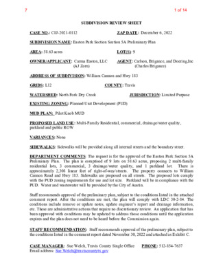
SUBDIVISION REVIEW SHEET LOT(S): 9 COUNTY: Travis (AJ Zorn) ZAP DATE: December 6, 2022 JURISDICTION: Limited Purpose AGENT: Carlson, Brigance, and Doering,Inc (Charles Brigance) CASE NO.: C8J-2021-0112 SUBDIVISION NAME: Easton Park Section Section 5A Preliminary Plan AREA: 58.63 acres OWNER/APPLICANT: Carma Easton, LLC ADDRESS OF SUBDIVISION: William Cannon and Hwy 183 GRIDS: L12 WATERSHED: North Fork Dry Creek EXISTING ZONING: Planned Unit Development (PUD) MUD PLAN: Pilot Knob MUD PROPOSED LAND USE: Multi-Family Residential, commercial, drainage/water quality, parkland and public ROW VARIANCES: None SIDEWALKS: Sidewalks will be provided along all internal streets and the boundary street. DEPARTMENT COMMENTS: The request is for the approval of the Easton Park Section 5A Preliminary Plan. The plan is comprised of 9 lots on 58.63 acres, proposing 2 multi-family residential lots, 3 commercial, 3 drainage/water quality, and 1 parkland lot. There is approximately 2,308 linear feet of right-of-way/streets. The property connects to William Cannon Road and Hwy 183. Sidewalks are proposed on all streets. The proposed lots comply with the PUD zoning requirements for use and lot size. Parkland will be in compliance with the PUD. Water and wastewater will be provided by the City of Austin. Staff recommends approval of the preliminary plan, subject to the conditions listed in the attached comment report. After the conditions are met, the plan will comply with LDC 30-2-84. The conditions include remove or update notes, update engineer’s report and drainage information, etc. These are administrative actions that require no discretionary review. An application that has been approved with conditions may be updated to address those conditions until the application expires and the plan does not need to be heard before the Commission again. STAFF RECOMMENDATION: Staff recommends approval of the preliminary plan, subject to the conditions listed in the comment report dated November 30, 2022 and attached as Exhibit C. CASE MANAGER: Sue Welch, Travis County Single Office Email address: Sue.Welch@traviscountytx.gov PHONE: 512-854-7637 1 of 147 Exhibit A: Easton Park 5A Preliminary Plan Exhibit B: Easton Park 5A Location Map Exhibit C: Easton Park 5A Preliminary Plan Comment Report 2 of 147 OOO13SHEETOFJOB NUMBERDATEFILE PATH:J:\AC3D\5367\dwg\PRELIMINARY\5367-PRELIMINARY PLAN.dwg - Sep 26, 2022 - 1:22pmDESIGNEDBY:DRAFTEDBY:BDFIRM ID #F3791Carlson, Brigance & Doering, Inc.CJOB NAME:PROJECT:SHEET NAME:Main Office5501 West William Cannon Dr.Austin, Texas 78749Phone No. (512) 280-5160Civil Engineering SurveyingNorth Office12129 RR 620 N., Ste. 600Austin, Texas 78750www.cbdeng.com5367EASTON PARK SECTION 5APRELIMINARY PLANCBCPJUNE 20213 of 147 2GENERAL NOTES3SHEETOFJOB NUMBERDATEFILE PATH:J:\AC3D\5367\dwg\PRELIMINARY\5367-PRELIMINARY PLAN.dwg - Sep 26, 2022 - 12:52pmDESIGNEDBY:DRAFTEDBY:BDFIRM ID #F3791Carlson, Brigance & Doering, Inc.CJOB NAME:PROJECT:SHEET NAME:Main Office5501 West William Cannon Dr.Austin, Texas 78749Phone No. (512) 280-5160Civil Engineering SurveyingNorth Office12129 RR 620 N., Ste. 600Austin, Texas 78750www.cbdeng.com5367EASTON PARK SECTION 5APRELIMINARY PLANCBCPJUNE 20214 of 147 OOOOOOO3PRELIMINARY PLAT - 100 SCALE3SHEETOFJOB NUMBERDATEFILE PATH:J:\AC3D\5367\dwg\PRELIMINARY\5367-PRELIMINARY PLAN.dwg - Sep 26, 2022 - 12:59pmDESIGNEDBY:DRAFTEDBY:BDFIRM ID #F3791Carlson, Brigance & Doering, Inc.CJOB NAME:PROJECT:SHEET NAME:Main Office5501 West William Cannon Dr.Austin, Texas 78749Phone No. (512) 280-5160Civil Engineering SurveyingNorth Office12129 RR 620 N., Ste. 600Austin, Texas 78750www.cbdeng.com5367EASTON PARK SECTION 5APRELIMINARY PLANCBCPJUNE 20215 of 147 CITY OF AUSTIN – TRAVIS COUNTY – SINGLE SUBDIVISION OFFICE SUBDIVISION APPLICATION – MASTER COMMENT REPORT UPDATE: PHONE #: U0 512-854-7637 C8J-2021-0112 00 Easton Park Section 5A Preliminary Plan 8300-8923 E WILLIAM CANNON DR CASE NUMBER: REVISION #: CASE MANAGER: Sue Welch PROJECT NAME: LOCATION: SUBMITTAL DATE: November 14, 2022 REPORT DUE DATE: December 1, 2022 FINAL REPORT DATE: November 30, 2022 STAFF REPORT: This report includes all staff comments received to date concerning your most recent subdivision application submittal. The comments may include requirements, recommendations, or information. The requirements in this report must be addressed by an updated submittal. The subdivision application will be approved when all requirements from each review discipline have been addressed. If you have any questions, concerns or if you require additional information about this report, please contact your case manager at the phone number listed above or by using the contact information listed for each reviewer in this report. Any change to the plan/plat shall not cause noncompliance with any applicable code or criteria. In addition, any change to the plat may trigger new comments. UPDATE DEADLINE (LDC 30-2-56; 30-2-82): All comments must be addressed by filing an updated submittal prior to the update deadline of (90 days from submittal) February 13, 2023. Otherwise, the application will expire. If this date falls on a weekend or City of Austin holiday, the next City of Austin workday will be the deadline. Extension of Review Period, Extension of Update Deadline and Tolling of Application Period do not apply to applications for preliminary plan, plat or subdivision construction plans (LDC). UPDATE SUBMITTAL INSTRUCTIONS (LDC 30-1-113): 1. 2. a. b. 3. list of approved submittal dates. REVIEWERS: A formal update submittal is required. Applicants must contact Intake Staff (974-1770) in order to submit an update. Your update must include the following items: The revised plat/plan in pdf format A letter that addresses each comment in the master comment report Updates must be submitted on an approved submittal date. Refer to the submittal calendar for a REVIEWERS: Planner 1: Chima Onyia Flood Plain: Kena Pierce ATD – Dari Majd PARD – Robynee Heymans Drainage Engineering Review - Judy Anderson Water Quality: Judy Anderson Floodplain – Kena Pierce Environmental – Mel Fuechec Travis Co. Subdivision: Sue Welch 911 Addressing: Janny Phung Travis Co. Transportation: Christine Connor Travis Co. Drainage Construction: Christine Connor 6 of 147 ATD Engineering Review - Dari Majd - 512-974-4024 ATD1. Please add the following note to the subdivision: Development of structures that require a building permit on this plat will be subject to the City of Austin Street Impact Fee as applicable prior to acquiring the building permit. ATD2. The Building Permits for this final plat are required to comply with the City’s Street Impact Fee. The fee was adopted by City Council in December 2020 and is applicable to all Building Permits submitted on or after June 22, 2022. (For more information: https://www.austintexas.gov/department/street-impact-fee). Please complete a copy of the SIF worksheet and submit it for review via the TDS KNACK Portal: https://atd.knack.com/development-services#sif-worksheet-portal/. Once the SIF estimator worksheet is finalized ATD staff will use the worksheet to generate a SIF Formal Calculation Memo to summarize potential future payments, including applicable reductions and Offset Agreements. LDC 25-6-662 ATD3. The ASMP requires 154 of right-of-way for East William Cannon Drive. Dedicate 77 feet of right- of-way from the existing centerline in accordance with the ASMP (LDC 25-6-55). ATD4. This preliminary plan must comply with the block length and connectivity requirements of the Pilot Knob PUD, Ordinance 20161110-032, Exhibit S, PUD notes 6 and 8. Please demonstrate compliance with these notes with the update. You may request relief from Note 8. If you wish to do so, please include the request with your next update. PARD / Planning & Design Review - Robynne Heymans - 512-974-9549 11/23/2022 Update 0 PR 1: Please clarify if any parkland, greenbelt parks are proposed to be dedicated within this preliminary plan. Park trails should connect any proposed multifamily units to the rest of the Easton Park trail system. All units must be within a ¼ mile walking distance of a park. PR 2: Please adjust the parkland note to include the lots proposed for parkland PR 3: Please provide a trails exhibit showing the trail alignment in this preliminary plan. PR 4: Please provide an open space and parkland calculator and master parkland tracking sheet for the proposed units in this preliminary plan. Electric Review - Andrea Katz - 512-322-6957 No Review Required. Out of Austin Energy service area, served by Bluebonnet Electric Cooperative, Inc. 911 Addressing Review - Janny Phung - janny.phung@austintexas.gov AD1: This plat review is cleared; however, any changes to street names, street name labels, or street layouts will require a new review. 7 of 147 AD2: S US 183 HWY is the correct name for this project NOTE: S US 183 HWY is incorrectly labeled as S US HWY 183 HWY The standards applied to all new street names in Travis County can be found at this link: http://www.austintexas.gov/sites/default/files/files/Information_Technology/911Addressing/Street_ Name_Standards.pdf §30-2-155 End of Comments Drainage Engineering Review - Judy Anderson - Judy.Anderson@austintexas.gov Release of this application does not constitute a verification of all data, information, and calculations supplied by the applicant. The engineer of record is solely responsible for the completeness, accuracy, and adequacy of his/her submittal, whether or not the application is reviewed for code compliance by city engineers. DE 1. The preliminary plan proposes shared use water quality and detention facilities for public ROW, and multiple private commercial and multifamily lots. A legal document is required for shared drainage infrastructure, please address. If applicable, the final plat may require a note referencing the legal document. [LDC 30-4-61 and 171-172] DE 2. Show all proposed drainage easements on the preliminary plan. There are concentrated offsite flows and/or floodplain through the property. A drainage easement is required to the limits of the 100 year fully developed flow elevation. Please address whether easements shown on the preliminary plan will be dedicated by plat or separate instrument. Clarify the drainage easement label on the plat. If any easements are proposed by separate instrument, when processing the final plat please submit easements with exhibits for processing. The drainage easement may be found link: http://www.austintexas.gov/page/common-easement-and- restrictive-covenants#pdrd. Update the engineering report to reference offsite flows and easements. [LDC 25-4-151 & 152] following through the DE 3. Address the unconcentrated offsite flows contributing to Lot 3/Block C. Clarify whether the proposed 25’ DE will be by plat or separate instrument. [LDC 30-4-151 & 152] DE 4. Address the existing drainage easement, Doc. No. 2016137313, which encroaches onto a proposed commercial lot. If an easement release is required, demonstrate the easement release will maintains compliance with all offsite conveyance requirements according to LDC 30-4-152 and 151. If the easement is dedicated to the City of Austin, the City’s Land Management Division administers an easement release application separately. [LDC 30-4-151 & 152] DE 5. Verify that drainage facilities (headwalls, open channels, storm sewers, area inlets, detention, retention, water quality controls) comply with Section 1.2.4 of the Drainage Criteria Manual. Especially consider, access drives (widths, grades), fences, staging areas, etc. Update the engineering report to clarify proposed pond location and footprints. [LDC 30-4-61 & 62] DE 6. The engineering report internal drainage area map uses an outdated street and lot layout. Update calculations and maps. Demonstrate impervious cover for the proposed parkland lot is considered, if applicable. [LDC 30-4-61 & 62] 8 of 147 DE 7. Demonstrate fully developed condition flows for the offsite contributing areas passing through site. The engineering report references 45% impervious cover on page 63, please provide supporting code/criteria. [LDC 30-4-61 & 62] DE 8. The existing internal drainage area map is missing, please provide. Demonstrate the same analysis points as shown on the proposed internal drainage area map. Additional analysis point locations may be necessary to demonstrate no increase in flows offsite. [LDC 30-4-61 & 62] DE 9. Engineering report Part I, Section 4, is missing detention information for proposed ROW and Lots 1/A, 1/B, and1/C. The location for the proposed pond, or whether stacked detention on Pond 1 and 2 is proposed is unclear. Part V, Internal Detention, appears to be for a single “Pond A”, and the single analysis point is not identified in an associated map. Please clarify the plan for detention and demonstrate a comprehensive plan for no increase in runoff. [LDC 30-4-61 & 62] DE 10. Address drainage infrastructure for the minor waterway crossings required for both Costa Vista Drive and driveway access to Lot 4/Block C. Note, storm drain infrastructure within easements are required to comply with the DCM. Address this topic in the engineering report. [LDC 30-4-151 and 152, LDC 30-4-62, DCM Section 5 and 7] DE 11. Proposed multifamily and commercial lots encroach on the Erosion Hazard Zone Buffer established by Watershed Protection Department. Conduct an analysis in accordance with City of Austin Drainage Criteria Manual Appendix E, Criteria for Establishing an Erosion Hazard Zone. Address lot conflicts and encroachments by subdivision infrastructure that effect the EHZ. Address this item in the engineering report. [LDC 30-4-32, DCM Appendix E] DE 12. Please add the following note, “An Erosion Hazard Zone Analysis was done with the preliminary plan for this subdivision.” [LDC 30-4-32, DCM Appendix E] DE 13. Please add the following note, "Prior to construction, except detached single family on any lot in this subdivision, a site development permit must be obtained from the City of Austin." [LDC 30-4- 61] DE 14. Please add the following note, “No structure shall be occupied until the water quality control and detention facility have been constructed, inspected, and accepted by the City of Austin. [LDC 30- 4-61] Environmental Review - Mel Fuechec - mel.fuechec@austintexas.gov IMPERVIOUS COVER COMMENTS [LDC 25, Subchapter A, Articles 9 through 13; ECM Appendices Q1 and Q2] EV 1 Provide the applicable ECM Appendix Q-2 table for the proposed impervious cover for the roadway pavement. The total proposed impervious cover must comply with the applicable watershed impervious cover limit in relation to the area of the right-of-way. For a commercial subdivision with an internal roadway, the platted lots will need to account for the roadway if the roadway exceeds the impervious cover limits within the right-of-way. *Note: Impervious cover for a Suburban watershed is based on Gross Site Area. Impervious cover for a Water Supply Suburban/Water Supply Rural/Barton Springs Zone watershed is based on Net Site Area and an ECM Appendix Q-1 table will also be required to be submitted with the ECM Appendix Q-2 table. 9 of 147 Flood Plain Review - Kena Pierce - 512-978-1832 Reviewer’s Notes: This application started the model review under the Project assessment. The remaining comments were provided upon submittal as well as the electronic floodplain model. Cleared comments have been removed. General notes: There are 3 tributaries located on the lot. The tributary on the far east has not been studied regarding the floodplain. The available COA and FEMA floodplains are caused from the main North Fork Dry Creek that is located to the south of the lot. There is no floodplain exhibit for either the tributary on the far east or the one that runs directly through Easton Palk Section 5A project assessment. Please state which tributaries have been reviewed and approved in the past, after discussion with Katina Bohrer it sounds like some of this floodplain has been reviewed in the past. Since these are critical components of conducting a thorough review, a full floodplain model review will be conducted once the following comments have been addressed. UPDATE 1: Case transferred to Katina Bohrer (so all Easton Park cases in Dry Creek/North Fork are reviewed by the same reviewer) Comments under LDC 30-4-33. FP1. Only post project HMS modeling has been provided. Please provide pre-project HMS modeling as well. UPDATE 2: Only post project modeling is provided. However, in order to move this project forward faster, I will only review aspects that are directly related to section 5A – it is possible that section 5A has no difference between pre project (fully developed) and post project conditions as only roadways appear to be proposed at this time. Please confirm. Update 3: Comment cleared. Response states that there is no difference in flows. FP2. HMS/RAS Flows Post Project Conditions - Provide information on how the first three flows on Trib 3 were determined – they do not correlate to any specific element in HMS. This should be explained somewhere in the report. UPDATE 2: comment not addressed. There is only 1 subbasin for Trib 3 (E1) which has a total outflow of 1396 cfs which is used in the RAS model at cross section 1265.61, but there are 3 flow change locations on this tributary upstream of this point and it is unclear how those flows were determined. Please explain where the flows for XS 4350, XS 3100, and XS 2100 came from. Update 2: Comment cleared. Flows are distributed along the tributary in the drainage area. It appears to be in a conservative manner. FP3. RAS – There are rises upstream of this project area. Confirm the flow change locations between existing and proposed – in existing conditions, the flow change happens well downstream of where the proposed 5A roadway crossing is, while in proposed conditions, there is a flow change just upstream of the bridge. This flow change almost triples the flows in the creek. UPDATE 2: There are rises upstream of this project due to the installation of the proposed roadway crossing. As the rises due to this project do not adversely affect William Cannon, and because the other projects upstream are owned by the same applicant, these rises may be addressed by dedication of drainage easement. Please confirm that applicant plans to mitigate rises with drainage easement dedication on affected properties. Update 3: Comment cleared. The rises upstream area located in a recorded drainage easement #2020132293 and again verified under under SP-2021-0235C. FP4. RAS – There are rises upstream of this project area. These rises are likely due to the blocked obstructions in post project conditions; these blocked obstructions should be in both pre and post 10 of 147 project conditions. See cross sections 3582.32 [also fix the fact that bank stations are in different locations between pre/post], 3319.4, 3087.72, 2892.91 [should have blocked obstructions for areas which are detention ponds, but doesn’t]. These blocked obstructions do change the WSEL and I suspect that once they are addressed properly, there won’t be any rises in outside of the 5A project area. UPDATE 2: There are rises upstream of this project due to the installation of the proposed roadway crossing (i.e. I tried to update the pre/post models to be the same off-site. I may have made an error somewhere as I was doing the updates quickly). As the rises due to this project do not adversely affect William Cannon, and because the other projects upstream are owned by the same applicant, these rises may be addressed by dedication of drainage easement. Please confirm that applicant plans to mitigate rises with drainage easement dedication on affected properties. Update 3: Comment cleared. The rises upstream area located in a recorded drainage easement #2020132293 and again verified under under SP-2021-0235C. FP5. RAS/HMS – I believe the last update I heard from Leif Moore was that the fill proposed in Joanne’s project was causing more water to get downstream faster thus creating an adverse impact. As adverse impacts can be addressed holistically for an overall project area, The 5A project area COULD potentially be used to ensure that water leaving the Easton Park development is slowed down enough so as not to cause an adverse impact (e.g. via an in-line pond). Please let reviewer know how Easton Park holistically plans to address the increase in flows (remember, it is always an option that Joann’s project be changed to ensure that flows do not get downstream faster). UPDATE 2: Pending review and acceptance of SP-2021-0235C Update 3: Comment pending. FP6. Confirm there are no proposed grading changes in Trib 3. If there are, a pre-project conditions model must be included for this tributary to compare pre/post. UPDATE 2: Applicant confirms there are no proposed grading changes on Trib 3. Update 3: Comment cleared. See U2 comments. FP7. Be aware that n-values appear appropriate around the proposed roadway at this time. As plans are fleshed out and environmental mitigation is determined, be aware that n-values may need to be altered in the future (likely to be addressed during subdivision construction when grading plans for the roadway are known). Update 3: Comment cleared. Noted. FP8. Be aware that to be compliant with LDC 25-7-33 and/or LDC 30-4-33, the FEMA floodplain which affects the eastern part of this area needs to be delineated and shown to be contained to drainage easement. Will be required during formal review of the Prelim. Update 3: Comment cleared. Drainage easements are shown and it appears that the floodplain is contained. FP9. Be aware that to be compliant with LDC 25-7-33 and/or LDC 30-4-33, the COA floodplain must be delineated on the prelim and shown to be contained to the drainage easement. Will be required during formal review of the Prelim. 11 of 147 1. 2. 3. Update 3: Comment cleared. Drainage easements are shown and it appears that the floodplain is contained. Reviewer’s Notes FYI: HMS modeling provided matches previous HMS models; the storm event used is hypothetical type III instead of frequency, but the two storm types effectively return the same flows for this area, so no changes are needed to the model at this time. FYI: RAS modeling provided generally matches previously submitted RAS models; the flow change locations are a bit on the liberal side for the tributaries, but not egregiously so, thus no changes are needed to flow change locations. Trib 3 is ONLY shown in post project conditions (not inherently a problem as long as no grading is being proposed within the floodplain area, though it is odd to have it only in post project and not in both pre and post project conditions) Water Quality Review - Judy Anderson - Judy.Anderson@austintexas.gov Release of this application does not constitute a verification of all data, information, and calculations supplied by the applicant. The engineer of record is solely responsible for the completeness, accuracy, and adequacy of his/her submittal, whether or not the application is reviewed for code compliance by city engineers. WQ 1. The preliminary plan proposes shared use water quality facilities for public ROW, and multiple private commercial and multifamily lots. A legal document is required for shared drainage infrastructure, please address. If applicable, the final plat may require a note referencing the legal document. [LDC 30-5-211] WQ 2. The R-Tables provided are missing an estimated required water quality volume. Demonstrate sufficient space for water quality infrastructure is planned for. [LDC 30-5-211] WQ 3. Verify water quality facilities have sufficient footprint to comply with Section 1.2.4 of the Drainage Criteria Manual. Especially consider, access drives (widths, grades), fences, staging areas, etc. [LDC 30-5-211] Wetlands Biologist Review - Leslie Lilly - Leslie.lilly@austintexas.gov No comments at this time. Travis Co. Subdivision Review - Sue Welch - 512-854-7637 An Educational Impact Statement may be required. Refer to Exhibit IV of the application. It is the responsibility of the applicant to submit the EIS to the appropriate school district. 30-1-113 Please provide the balance of the tract letter from the owner or verify if the PUD waives this requirement. 30-2-34 It appears a portion of this tract is within the COA Airport Overlay. Please add the note: “Development of these lots shall comply with the requirements of the Airport Hazard and compatible land use regulations (Chapter 25-13) as amended.” 30-1-113 12 of 147 4. 5. 1) 1) Verify if an administrative block length waiver is required for lot 4. 30-1-113 Once all comments are cleared, provide the signatures, signed and sealed mylars (pdf). Please contact this reviewer. 30-1-113 Travis Co. Transportation Review - Christine Connor - 512-854-7215 Provide proof of coordination with the adjacent land owner for the road extension. (30-2-59) Travis Co. Drainage Construction Review - Christine Connor - 512-854-7215 Provide a signed and sealed copy of the Title 30 Compliance Summary. End of Master Comment Report 13 of 147 Legend Street Labels Jurisdiction FULL PURPOSE LIMITED PURPOSE OTHER CITY LIMITS OTHER CITIES ETJ TCAD Parcels TCAD Parcel IDs Jurisdiction FULL PURPOSE LIMITED PURPOSE EXTRATERRITORIAL JURISDICTION 2 MILE ETJ AGRICULTURAL AGREEMENT EXTRATERRITORIAL JURISDICTION 2 MILE ETJ AGRICULTURAL AGREEMENT OTHER CITY LIMITS OTHER CITIES ETJ Subdivision Review Cases (All) Zoning Lake Austin, Rural Residence (LA; RR) Single Family (SF-1; SF-2; SF-3; SF-4A; SF-4B; SF-5; SF-6) Mobile Home (MH) Multi-family (MF-1; MF-2; MF-3; MF-4; MF-5; MF-6) Commercial (CH; CR; CS; CS-1; GR; L; LR) Office (GO; LO; NO) Industrial (IP; LI; MI; R&D; W/LO) CBD; Downtown Mixed Use (DMU) ERC; NBG; TND; TOD Planned Unit Development (PUD) Agriculture, Development Reserve (AG, DR) Aviation, Public, Unzoned (AV; P; UNZ) 0.2 7-16-21 NAD_1983_StatePlane_Texas_Central_FIPS_4203_Feet 0 0.08 0.2 Miles This product is for informational purposes and may not have been prepared for or be suitable for legal, engineering, or surveying purposes. It does not represent an on-the-ground survey. This product has been produced by the City of Austin for the sole purpose of geographic reference. No warranty is made by the City of Austin regarding specific accuracy or completeness. 1: 4,800 Unclassified Zoning Text Notes Easton Park 5A Preliminary Plan 14 of 147