B-02 (C14-2020-0041 - Stowers and Schiller; District 10) — original pdf
Backup
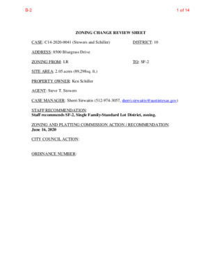
ZONING CHANGE REVIEW SHEET CASE: C14-2020-0041 (Stowers and Schiller) DISTRICT: 10 ADDRESS: 8500 Bluegrass Drive ZONING FROM: LR TO: SF-2 SITE AREA: 2.05 acres (89,298sq. ft.) PROPERTY OWNER: Ken Schiller AGENT: Steve T. Stowers CASE MANAGER: Sherri Sirwaitis (512-974-3057, sherri.sirwaitis@austintexas.gov) STAFF RECOMMENDATION: Staff recommends SF-2, Single Family-Standard Lot District, zoning. ZONING AND PLATTING COMMISSION ACTION / RECOMMENDATION: June 16, 2020 CITY COUNCIL ACTION: ORDINANCE NUMBER: 1 of 14B-2 C14-2020-0041 2 ISSUES: N/A CASE MANAGER COMMENTS: The property in question is currently undeveloped. The lots to the north are zoned SF-2-CO and are developed with single-family residences. To the south and east, there are PUD and LO zoned tracts that contain office buildings. To the west, there is undeveloped land that was originally right-of-way area for the construction of Arterial 8. The applicant’s request to change in the intensity of land use at this site is consistent with the deletion of Arterial 8 (Forsythia Drive), a ninety-foot arterial roadway that was to connect Loop 360 to Yaupon Drive. The City of Austin’s plans to construct Arterial 8 changed, due in part to BCCP issues and with the City’s purchase of the adjoining Stennis Tract. In this request, the applicant is asking to down zone this tract of land to build a single-family residence on the site. The staff recommends SF-2 zoning as the property meets the intent of the Single-Family Residence-Standard Lot district designation and is consistent with the SF- 2-CO zoning the north and west. SF-2 zoning will allow the applicant to develop the property with a single-family residence that is compatible with the residential uses adjacent to the site. The applicant agrees with the staff’s recommendation. BASIS OF RECOMMENDATION: 1. The proposed zoning should be consistent with the purpose statement of the district sought. Single-Family Residence (Standard Lot) district is intended as an area for moderate density single-family residential use, with a minimum lot size of 5,750 square feet. This district is appropriate for existing single-family neighborhoods having moderate sized lot patterns, as well as for development of additional single-family housing areas with minimum land requirements. 2. The proposed zoning should promote consistency and orderly planning. The proposed SF-2 zoning is consistent with the existing SF-2-CO zoning to the north and west. 3. The proposed zoning should allow for a reasonable use of the property. SF-2 zoning will allow the applicant to develop the property with a single-family residence that is compatible with the residential uses adjacent to site. 2 of 14B-2 C14-2020-0041 3 EXISTING ZONING AND LAND USES: ZONING LAND USES Site North South East West LR SF-2-CO PUD LO SF-2-CO Undeveloped Single Family Residences Office (Prominent Pointe) Office (Great Hills) Single Family Residences, Undeveloped NEIGHBORHOOD PLANNING AREA: N/A TIA: Not Required WATERSHED: Bull Creek SCHOOLS: Austin I.S.D. Hill Elementary School Murchison Middle School Anderson High School NEIGHBORHOOD ORGANIZATIONS: Austin Great Hills Homeowners Association, Inc. Austin Independent School District Bike Austin Bull Creek Foundation Friends of Austin Neighborhoods Great Hills VII HOA Long Canyon Homeowners Association Mountain Neighborhood Association (MNA) Neighborhood Empowerment Foundation North Oaks Neighborhood Association SELTEXAS Sierra Club, Austin Regional Group TNR BCP-Travis County Natural Resources AREA CASE HISTORIES: REQUEST GR-CO, RR to GR-CO, RR NUMBER C14-2011-0062 (Junior League Office: 8501 Bluffstone Cove) COMMISSION 9/06/11: Approved the staff’s recommendation of GR-CO and RR district zoning on consent, adding Bail Bond Services to the conditional overlay as a prohibited use (5-0, S. Baldridge-absent); CITY COUNCIL 9/22/11: Approved GR-CO and RR zoning on consent on all 3 readings (7-0); B. Spelman-1st, L. Morrison-2nd. 3 of 14B-2 C14-2020-0041 4 I-RR, SF-2-CO, LO, GR, PUD to PUD P. Seager-1st, C. Banks-2nd. 6/20/06: Approved staff recommendation of PUD zoning by consent (7-0, S. Hale, J. Gohil-absent); J. Martinez-1st, M. Hawthorne- 2nd. C814-06-0054 (Prominent Pointe II PUD: 5401, 5405, 5505 Bluffstone Lane; 8310 N. Capital of Texas Highway; Bluffstone at Bluegrass Drive 7/27/06: Approved PUD zoning by consent, with the following conditions: 1) Parking requirements are temporarily adjusted to the extent necessary during demolition of the existing surface parking and demolition of the existing surface parking and construction of the parking garage to allow continued occupancy of the existing building; 2) Requirements for construction sequencing are temporarily adjusted to allow construction of the parking garage and utilities to utilize the existing pond and allow construction of the new pond to occur after the garage utilities are completed (7-0); 1st reading 8/09/06: Approved 2nd/3rd readings for planned unit development (PUD) district zoning, including the following language in the Restrictive Covenant: Restrictive Covenant Language, Page 2, Number 8 will read, “Requirements for construction sequencing are temporarily modified to allow construction of the building, parking garage and utilities to utilize the existing pond and additional erosion and sedimentation controls to allow the construction of the new pond to occur after the garage and utilities are completed.” Vote: (7-0); B. McCracken-1st, B. Dunkerley-2nd. 1/17/02: Approved PUD on 3 readings (6-0, Wynn out of room) C814-01-0096 GR, LR to PUD 12/04/01: Approved staff’s recommendation of PUD zoning by consent (8-0, M. Casias-absent) 4 of 14B-2 C14-2020-0041 5 C14-97-0100 SF-2 to GR 10/23/97: Approved GR-CO & RR for floodplain w/conditions (7-0), subject to 25% maximum impervious cover; 1st reading 1/15/98: Approved GR-CO & RR w/ conditions (7-0); 2nd/3rd readings 9/16/97: Approved GR-CO, prohibiting the following uses: Lodginghouse Residential, Administrative and Business Offices, Art and Craft Studio (Limited), Automotive Rentals, Automotive Repair Services, Automotive Sales, Automotive Washing, Business or Trade School, Business Support Services, Commercial Off-Street Parking, Communications Services, Consumer Convenience Services, Consumer Repair Services, Drop-Off Recycling Collection Facility, Exterminating Services, Food Sales, Funeral Services, General Retail Sales (Convenience, General), Hotel-Motel, Indoor Entertainment, Indoor Sports and Recreation, Off-Site Accessory Parking, Outdoor Entertainment, Outdoor Sports & Recreation, Pawn Shop Services, Personal Improvement Services, Personal Services, Pet Services, Research Services, Restaurant (Drive-In, Fast Food), Restaurant (Limited), Service Station, Special Use Historic, Small Plant Nursery, Theater, Club or Lodge, College or University Facilities, Communication Service Facilities, Community Recreation (Private, Public), Counseling Services, Cultural Services, Day Care Services (Limited, General, Commercial), Guidance Services, Hospital Services (Limited, General), Local Utility Facilities, Safety 5 of 14B-2 C14-2020-0041 6 Services, Private Primary Educational Facilities, Private Secondary Educational Facilities, Public Primary Educational Facilities, Public Secondary Educational Facilities, Residential Treatment, Telecommunication Tower, and Congregate Living (7-0) 9/16/97: Approved staff rec. of SF-2 (7-0) C14-97-0098 SF-6 to SF-2 C14r-86-193 LO to GR C14r-86-045 TR1: SF-2, DR to LR TR2: SF-2, DR to GR 9/23/86: Approved GR zoning subject to conditions (8-0) 7/01/86: Approved LR (TR1) and GR (TR2), subject to conditions (9-0) 7/01/86: Approved LO (7-2) SF-2, DR to LO C14r-86-044 RELATED CASES: C14-97-0098 - Previous Rezoning Case C8-2019-0196.0A - Subdivision Case in Review EXISTING STREET CHARACTERISTICS: 10/23/97: Approved SF-2-CO w/ conditions (7-0), subject to 25% maximum impervious cover; 1st reading 1/15/98: Approved SF-2-CO w/conditions (7-0); 2nd/3rd readings 10/08/86: Approved GR subject to conditions (6-0); all 3 readings 8/28/86: Approved LR, GR (6-0); 1st reading 1/15/87: Approved LR and GR; 2nd/ 3rd readings 10/30/86: Approved LO Name Existing ROW ASMP Required ROW Pavement ASMP Classification Sidewalks Bicycle Route Capital Metro (within ¼ mile) Bluegrass Drive Bluffstone Lane ~60’ ~89’ 70’ 92’ 38’ 56’ 2 2 No No Yes No No No 6 of 14B-2 C14-2020-0041 7 OTHER STAFF COMMENTS: Comprehensive Planning This zoning case is situated on a 2.05 acre vacant lot, located on the northwest corner of Bluffstone Drive and Bluegrass Drive, which is continuation of Spicewood Springs Road, which is located on the other side of Highway 360. The property is 1.4 miles driving distance from the North Burnet/Gateway Station Regional Center. This case is not located within the boundaries of a neighborhood planning area. Surrounding land uses includes single family houses to the north; to the south and east are several office buildings; and to the west is vacant land. The proposed used is large lot single family housing. Connectivity There are no existing public sidewalks, bike lanes, or public transit stops along this portion of Bluffstone Lane, which is a hilly road. The connectivity and mobility options in this are below average. Imagine Austin The property is not located along or near an Activity Center or Corridor. Based on the comparative scale of this site relative to mix of uses in the area, including residential (although there is a lack of mobility and connectivity options in the area), this project supports the Imagine Austin Comprehensive Plan. Environmental The site is not located over the Edwards Aquifer Recharge Zone. The site is in the Bull Creek Watershed of the Colorado River Basin, which is classified as a Water Supply Suburban Watershed by Chapter 25-8 of the City's Land Development Code. It is in the Drinking Water Protection Zone. Under the current watershed regulations, development or redevelopment on this site will be subject to the following impervious cover limits: % of Net Site Area % NSA with Transfers Development Classification One or Two Family Residential 30% 40% Multifamily Residential Commercial 40% 40% 55% 55% Development within a Water Quality Transition Zone is limited to 18%. According to floodplain maps there is a floodplain within or adjacent to the project location. Based upon the location of the floodplain, offsite drainage should be calculated to determine whether a Water Quality Transition Zone / Critical Water Quality Zone exist within the project location. 7 of 14B-2 C14-2020-0041 8 Standard landscaping and tree protection will be required in accordance with LDC 25-2 and 25-8 for all development and/or redevelopment. At this time, site specific information is unavailable regarding vegetation, areas of steep slope, or other environmental features such as bluffs, springs, canyon rimrock, caves, sinkholes, and wetlands. Under current watershed regulations, development or redevelopment requires water quality control with increased capture volume and control of the 2 year storm on site. At this time, no information has been provided as to whether this property has any preexisting approvals that preempt current water quality or Code requirements. Site Plan Site plans will be required for any new development other than single-family or duplex residential. COMPATIBILITY Any development which occurs in an SF-6 or less restrictive zoning district which is located 540-feet or less from property in an SF-5 or more restrictive zoning district will be subject to compatibility development regulations. The site is subject to compatibility standards. Along the northern property lines, the following standards apply: - No structure may be built within 25 feet of the triggering property lines. - No structure in excess of two stories or 30 feet in height may be constructed - No structure in excess of three stories or 40 feet in height may be constructed within 50 feet of the property line. within 100 feet of the property line. - No parking or driveways are allowed within 25 feet of the property line. - A fence, berm, or dense vegetation must be provided to screen adjoining - properties from views of parking, mechanical equipment, storage, and refuse collection. for a structure more than 100 feet but not more than 300 feet from property zoned SF-5 or more restrictive, 40 feet plus one foot for each 10 feet of distance in excess of 100 feet from the property zoned SF-5 or more restrictive. - An intensive recreational use, including a swimming pool, tennis court, ball court, or playground, may not be constructed 50 feet or less from adjoining SF-3 property. Additional design regulations will be enforced at the time a site plan is submitted. 8 of 14B-2 C14-2020-0041 9 SUBCHAPTER E Any new development is subject to Subchapter E. Design Standards and Mixed Use. This site will be subject to Suburban Roadway – Corner Lot standards. Additional comments will be made when the site plan is submitted. ZONING OVERLAYS FYI- This is in the Scenic Roadway Overlay. Transportation The Austin Strategic Mobility Plan (ASMP) adopted 04/11/2019, calls for 70 feet of right-of- way for Bluegrass Drive. It is recommended that 35 feet of right-of-way from the existing centerline should be dedicated for Bluegrass Drive at the time of subdivision or site plan. The ASMP calls for 92’ of right-of-way for Bluffstone Lane. It is recommended that 46’ of right-of-way should be dedicated for Bluffstone Lane at the time of subdivision or site plan. A traffic impact analysis is not required at this time. Water Utility The landowner intends to serve the site with City of Austin water and wastewater utilities. The landowner, at own expense, will be responsible for providing any water and wastewater utility improvements, offsite main extensions, utility relocations and or abandonments required by the land use. The water and wastewater utility plan must be reviewed and approved by Austin Water for compliance with City criteria and suitability for operation and maintenance. Depending on the development plans submitted, water and or wastewater service extension requests may be required. All water and wastewater construction must be inspected by the City of Austin. The landowner must pay the City inspection fee with the utility construction. The landowner must pay the tap and impact fee one the landowner makes an application for a City of Austin water and wastewater utility tap permit. INDEX OF EXHIBITS TO FOLLOW A: Zoning Map B. Aerial Map C. Correspondence from Interested Parties 9 of 14B-2 DR S P I C E W O O D S P R I N G S R D MF-3 SF-2 93-0113 ANNEX 911219-U CYRILLA DR DR S P U R F L O W E R C V ( ( SF-2 ( ( ( EXHIBIT A PUD ( SP U R FL O WER DR 099 97-0 85-028 C814-06-0054 97-0098 PUD C814-06-0054 C814-06-0054 97-0098 C814-06-0054 4 5 0 6 - 0 4 - 0 1 8 C 9 7 - 0 0 9 8 SF-2 DR A L A T A C V 97-0099 SF-2-CO C14-97-0099 B L U E G R A S S D R SF-2-CO C14-97-0098 97-0098 C 8 1 4 - 0 6 - 0 0 5 4 SF-6 C14-85-028 85-028 I-RR UNDEV SF-3 AG LO C14-02-0096 SPC-02-0038A R86-044 LO 79-133 PUD ! ! ! ! ! ! ! ! ! ! ! ! B L U ! ! F F S T ! ! LR ! ! ! ! ! O N ! E L N ! ! ! C814-01-0096 R86-045 V E C N B L U F F S T O 97-0100 GR-CO C14-2011-0062 C14-97-0100 RR 97-0100 97-0100 C814-06-0054 PUD GR-CO SP-06-0452D C814-06-0054 86-193 PUD OFFICE SPC-06-0026C 84-170 SF-2 A S H X Y S B W A S H X B Y N W PIT A L O F T E PIT A L O F T E A N C A N C MF-3 71-115 ( ( A D I R O ( N D A C K C V SF-2 MF-2 S P I C E W O O D S P R I N G S R D P ± SUBJECT TRACT ! ! ! ! ! ! PENDING CASE ZONING BOUNDARY ZONING ZONING CASE#: C14-2020-0041 This product is for informational purposes and may not have been prepared for or be suitable for legal, engineering, or surveying purposes. It does not represent an on-the-ground survey and represents only the approximate relative location of property boundaries. 1 " = 400 ' This product has been produced by CTM for the sole purpose of geographic reference. No warranty is made by the City of Austin regarding specific accuracy or completeness. Created: 3/19/2020 10 of 14B-2 G33 PUD H33 SF-2 SF-2 DR SF-2-CO B L U E G R A S S D R SF-2-CO SF-6 C14-2020-0041 LR H32 B L U F F S T O N E L N G32 I-RR LO V E C N B L U F F S T O GR-CO PUD RR PUD GR-CO ± 1'' = 200' SUBJECT TRACT ZONING BOUNDARY ! ! ! ! ! ! PENDING CASE CREEK BUFFER STOWERS AND SCHILLER ZONING CASE#: LOCATION: SUBJECT AREA: GRID: MANAGER: C14-2020-0041 8500 BLUEGRASS DR. 2.05 ACRES H32 Sherri Sirwaitis This map has been produced by the Communications Technology Management Dept. on behalf of the Planning Development Review Dept. for the sole purpose of geographic reference. No warranty is made by the City of Austin regarding specific accuracy or completeness. 11 of 14B-2 G33 PUD H33 SF-2 SF-2 EXHIBIT B DR SF-2-CO B L U E G R A S S D R SF-2-CO SF-6 C14-2020-0041 LR H32 B L U F F S T O N E L N G32 I-RR LO V E C N B L U F F S T O GR-CO PUD RR PUD GR-CO Copyright nearmap 2015 ± 1'' = 200' SUBJECT TRACT ZONING BOUNDARY ! ! ! ! ! ! PENDING CASE CREEK BUFFER STOWERS AND SCHILLER ZONING CASE#: LOCATION: SUBJECT AREA: GRID: MANAGER: C14-2020-0041 8500 BLUEGRASS DR. 2.05 ACRES H32 Sherri Sirwaitis This map has been produced by the Communications Technology Management Dept. on behalf of the Planning Development Review Dept. for the sole purpose of geographic reference. No warranty is made by the City of Austin regarding specific accuracy or completeness. 12 of 14B-2 EXHIBIT C 13 of 14B-2 14 of 14B-2