B-05 (SP-2019-0189D - Xspace Group).pdf — original pdf
Backup
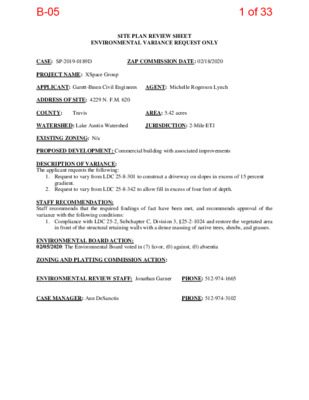
SITE PLAN REVIEW SHEET ENVIRONMENTAL VARIANCE REQUEST ONLY ZAP COMMISSION DATE: 02/18/2020 CASE: SP-2019-0189D PROJECT NAME: XSpace Group APPLICANT: Garett-Ihnen Civil Engineers AGENT: Michelle Rogerson Lynch ADDRESS OF SITE: 4229 N. F.M. 620 COUNTY: WATERSHED: Lake Austin Watershed EXISTING ZONING: N/a PROPOSED DEVELOPMENT: Commercial building with associated improvements DESCRIPTION OF VARIANCE: The applicant requests the following: JURISDICTION: 2-Mile ETJ AREA: 5.42 acres Travis 1. Request to vary from LDC 25-8-301 to construct a driveway on slopes in excess of 15 percent gradient. 2. Request to vary from LDC 25-8-342 to allow fill in excess of four feet of depth. STAFF RECOMMENDATION: Staff recommends that the required findings of fact have been met, and recommends approval of the variance with the following conditions: 1. Compliance with LDC 25-2, Subchapter C, Division 3, §25-2-1024 and restore the vegetated area in front of the structural retaining walls with a dense massing of native trees, shrubs, and grasses. ENVIRONMENTAL BOARD ACTION: 02/05/2020: The Environmental Board voted in (7) favor, (0) against, (0) absentia ZONING AND PLATTING COMMISSION ACTION: ENVIRONMENTAL REVIEW STAFF: Jonathan Garner CASE MANAGER: Ann DeSanctis PHONE: 512-974-1665 PHONE: 512-974-3102 1 of 33B-05 ENVIRONMENTAL COMMISSION MOTION 20200205 006a Date: February 5, 2020 Subject: XSpace Group, SP-2019-0189D Motion by: Katie Coyne Seconded by: Mary Ann Neely RATIONALE: WHEREAS, the Environmental Commission recognizes the applicant is requesting variances from: • LDC 25-8-301 to construct a driveway on slopes in excess of 15 percent gradient; and, • LDC 25-8-342 to allow fill in excess of four feet of depth. WHEREAS, the Environmental Commission recognizes that staff recommends the approval of this variance because the findings of fact have been met. THEREFORE, the Environmental Commission recommends approval of the requested variances listed above. For: Bedford, Creel, Nill, Guerrero, Coyne, Neely, and Gordon Against: None Abstain: None Recuse: Ramberg Absent: Smith, Thompson, and Maceo VOTE 7-0 Approved By: Linda Guerrero, Environmental Commission Chair 1 2 of 33B-05 Staff Findings of Fact Variance to LDC 25-8-301 3 of 33B-05 Development Services Department Staff Recommendations Concerning Required Findings Construction of a driveway on slopes in excess of 15 percent (LDC 25-8-301) Project Name: Ordinance Standard: Watershed Protection Ordinance Variance Request: XSpace Group SP-2019-0189D Include an explanation with each applicable finding of fact. A. Land Use Commission variance determinations from Chapter 25-8-41 of the City Code: 1. The requirement will deprive the applicant of a privilege available to owners of similarly situated property with approximately contemporaneous development subject to similar code requirements. Yes. The entire portion of the property fronting the public right-of-way contains slopes in excess of 15 percent. The other three sides of the property are bound by private development, and there is no other alternative access into the site. Therefore, the only available access into the property and to the approximate 1.33 acres of developable land on the property (e.g., slopes 0-15 percent) is by crossing the existing slopes with a private driveway. 2. The variance: a) b) Is not necessitated by the scale, layout, construction method, or other design decision made by the applicant, unless the design decision provides greater overall environmental protection than is achievable without the variance; Yes. The only available access into the property and to the approximate 1.33 acres of developable land on the property (e.g., slopes 0- 15 percent) is by crossing the existing slopes with a private driveway. Is the minimum deviation from the code requirement necessary to allow a reasonable use of the property; Yes. Code and Criteria allow a driveway to be constructed on slopes over 15% when the driveway provides primary access to a minimum of two contiguous acres of land with a slope less than 15 percent. However, the topography of the property is 4 of 33B-05 characterized by alternating bands of slopes less than 15 percent and slopes greater than 15 percent (see slope exhibit, p. X). Collectively, there are over three acres of land with slopes less than 15 percent, yet they are not contiguous. The proposed driveway is directly perpendicular to FM 620, and is located on the narrowest band of slopes in excess of 15 percent. This allows for the remaining portion of the development to be located on an area of approximately 1.33 acres of land with slopes less than 15 percent. The variance is based on the development’s requirement to access the buildable land and to comply with vertical slope requirements set forth by Austin Fire and Travis County Fire and Rescue. If the driveway were proposed elsewhere along the property frontage, it would have to cross slopes in excess of 25 percent gradient, and would locate other development on slopes steeper than 15 percent. c) Does not create a significant probability of harmful environmental consequences. Yes. No significant trees or vegetation will be removed for the construction of the driveway, the driveway is not proposed to cross a naturally occurring waterway, and there are no critical environmental features (CEFs) present that will be impacted by the construction of the driveway. 3. Development with the variance will result in water quality that is at least equal to the water quality achievable without the variance. Yes. The fill required to construct the driveway on slopes will be structurally contained to minimize or eliminate any erosive flows post-construction, and appropriately sized culverts will be included to allow offsite flows to continue through the site in accordance with existing conditions. B. The Land Use Commission may grant a variance from a requirement of Section 25-8- 422 (Water Supply Suburban Water Quality Transition Zone), Section 25-8-452 (Water Supply Rural Water Quality Transition Zone), Section 25-8-482 (Barton Springs Zone Water Quality Transition Zone), Section 25-8-368 (Restrictions on Development Impacting Lake Austin, Lady Bird Lake, and Lake Walter E. Long), or Article 7, Division 1 ( Critical Water Quality Zone Restrictions ), after determining that:: 1. The criteria for granting a variance in Subsection (A) are met; N/A. N/A. 2. 3. The requirement for which a variance is requested prevents a reasonable, economic use of the entire property; The variance is the minimum deviation from the code requirement necessary to allow a reasonable, economic use of the entire property. 5 of 33B-05 N/A. Staff Determination: Staff determines that the findings of fact have been met. Staff recommends the following conditions: 1. Compliance with LDC 25-2, Subchapter C, Division 3, §25-2-1024 and restore the vegetated area in front of the structural retaining walls with a dense massing of native trees, shrubs, and grasses; Environmental Reviewer (DSD) _____________________________ Jonathan Garner Date December 31, 2019 Environmental Review Manager (DSD) _____________________________ Mike McDougal Date January 2, 2020 Environmental Officer (WPD) _____________________________ Chris Herrington Date ________________ 6 of 33B-05 Application Form Variance to LDC 25-8-301 7 of 33B-05 ENVIRONMENTAL BOARD VARIANCE APPLICATION TEMPLATE December 11, 2019 December 11, 2019 Dennis Lucas, Director Planning and Zoning Department City of Austin P.O. Box 1088 Austin, TX 78767 RE: Variance Request Letter X Space Group 4229 N FM 620 RD SP‐2019‐0189 D § 25‐8‐301 ‐ CONSTRUCTION OF A ROADWAY OR DRIVEWAY Dear Ms. Lucas: On behalf of the owners, 4229 N. FM 620 / X Space Group, we are requesting a variance for constructing a segment of driveway on sloes that exceed 15% for the proposed development of the X Space Group site development permit (SP‐2019‐0189d) located at 4229 N FM 620 RD. The subject project is located approximately 0.4 miles west of the full purpose annexed area of Lake Austin and therefore is within the 2‐mile ETJ. The property is currently undeveloped and is located at the south west corner of FM 620 and Scenic Overlook Drive. The applicant plans to develop a new building with fire lanes and parking area. The applicant proposes to place new improvements on the property in a way to minimize adverse impacts to the natural character of the property. The site is located within the Drinking Water Protection Zone; however, the subject tract is not located over the Edwards Aquifer Recharge Zone. The site is in the Lake Austin Watershed of the Colorado River Basin and is classified as a Water Supply Suburban Watershed by Chapter 25‐8 of the City’s Land Development Code. The property is within the Golden‐cheeked Warbler‐Zone 1 (Confirmed habitat) and will be seeking participation in the Balcones Canyonlands Conservation Program as administered by Travis County. City of Austin | Environmental Board Variance Application Guide 1 8 of 33B-05 December 11, 2019 At least forty percent (40%) of the site, excluding dedicated right‐of‐ way, shall be left in a natural state. The project requires leniency from the following code sections: Division 5. ‐ Cut, Fill, and Spoil. Division 3. ‐ Construction on Slopes. § 25‐8‐301 ‐ CONSTRUCTION OF A ROADWAY OR DRIVEWAY. (A) A person may not construct a roadway or driveway on a slope with a gradient of more than 15 percent unless the construction is necessary to provide primary access to: (1) at least two contiguous acres with a gradient of 15 percent or less; or (2) building sites for at least five residential units. (B) For construction described in this section, a cut or fill must be revegetated, or if a cut or fill has a finished gradient of more than 33 percent, stabilized with a permanent structure. This does not apply to a stable cut. The Land Development Code allows Land Use Commission Variances per the following: Division 3. ‐ Variances. § 25‐8‐41 ‐ LAND USE COMMISSION VARIANCES. (A) It is the applicant's burden to establish that the findings described in this Section have been met. Except as provided in Subsections (B) and (C), the land use commission may grant a variance from a requirement of this subchapter after determining that: (1) the requirement will deprive the applicant of a privilege available to owners of other similarly situated property with approximately contemporaneous development subject to similar code requirements; (2) the variance: (a) is not necessitated by the scale, layout, construction method, or other design decision made by the applicant, unless the design decision provides greater overall environmental protection than is achievable without the variance; (b) is the minimum deviation from the code requirement necessary to allow a reasonable use of the property; and (c) does not create a significant probability of harmful environmental consequences; and (3) development with the variance will result in water quality that is at least equal to the water quality achievable without the variance. City of Austin | Environmental Board Variance Application Guide 2 9 of 33B-05 Below you will find the findings of fact concerning the need for the variance. Your favorable consideration and support of our request would be appreciated. If you have any questions, please feel free to call. December 11, 2019 Sincerely, Steven L. Ihnen, P.E. TBPE Firm #F‐630 City of Austin | Environmental Board Variance Application Guide 3 10 of 33B-05 December 11, 2019 PROJECT DESCRIPTION Applicant Contact Information Name of Applicant Street Address City State ZIP Code Work Phone E-Mail Address Garrett-Ihnen Civil Engineers 12007 Technology Blvd. Austin, TX 78727 512‐454‐2400 permitting@gice.us Variance Case Information XSpace Group Storage Case Name Case Number Address or Location Environmental Reviewer Name Applicable Ordinance Watershed Name Watershed Classification SP‐2019‐0189D 4229 N. FM 620 Jonathan Garner Current Code Lake Austin ☐Urban ☐Water Supply Rural ☐ Suburban ☐ Water Supply Suburban ☐ Barton Springs Zone Edwards Aquifer Recharge Zone ☐ Barton Springs Segment ☐ Not in Edwards Aquifer Zones ☐ Northern Edwards Segment Edwards Aquifer Contributing Zone Distance to Nearest Classified Waterway Water and Waste Water service to be provided by Request ☐ Yes ☐ No 0.40 mile WCID#17 and On‐site septic § 25‐8‐301 ‐ CONSTRUCTION OF A ROADWAY OR DRIVEWAY City of Austin | Environmental Board Variance Application Guide 4 11 of 33B-05 December 11, 2019 Impervious cover square footage: acreage: percentage: Provide general description of the property (slope range, elevation range, summary of vegetation / trees, summary of the geology, CWQZ, WQTZ, CEFs, floodplain, heritage trees, any other notable or outstanding characteristics of the property) Existing _702 sf _5.43 ac._____ ___0.4%_____ Proposed ____44,518_sf____ ____5.43 ac._____ ____25.73%_____ The property has slopes that vary from 0% to over 35%. The slope breakdown is as follows: 0‐15% Slopes 3.236 acres 15‐25% Slopes 0.630 acres 25‐35% Slopes .107 acres Over 35% Slopes 0.080 acres Elevation ranges from a low point of 739.23 to a high point of 843. The ground vegetation is typical hill country grasses in poor condition due to a heavy over cover of cedar trees and poor topsoil due to limestone substrata. The geology is hard to slightly weathered limestone with no or little top soils. In areas where topsoil exists, the soil is brown hard flat clay with limestone gravel fragments. The site as no CWQZ, WQTZ, CEFs, floodplain, heritage trees, or any any other notable or outstanding characteristics of the property. Clearly indicate in what way the proposed project does not comply with current Code (include maps and exhibits) The plan complies with all current codes. City of Austin | Environmental Board Variance Application Guide 5 12 of 33B-05 December 11, 2019 FINDINGS OF FACT § 25‐8‐41(A)(1): The requirement will deprive the applicant of a privilege available to owners of other similarly situated property with approximately contemporaneous development subject to similar code requirements. ANSWER: There exists 1.33 acres of land with slopes of 0 to 15% that is separated for access to FM 620 by a band of slopes greater than 15%. Without a variance, this property is rendered undevelopable compared to similarly situated properties located along FM 620. § 25‐8‐41(A)(2)(a): The variance is not necessitated by the scale, layout, construction method, or other design decision made by the applicant, unless the design decision provides greater overall environmental protection than is achievable without the variance. ANSWER: Existing conditions of the property necessitate the construction on slopes variance. There exists 1.33 acres of land with slopes of 0 to 15% that is inaccessible without crossing slopes greater than 15% without a variance. The project proposes to construct all of its developable area concentrated in this 1.33 acre area and is scaled appropriately. § 25‐8‐41(A)(2)(b): The variance is the minimum deviation from the code requirement necessary to allow a reasonable use of the property. ANSWER: The proposed building site is located in the only area that is developable on the site. In order to access this point, the construction on slopes is required. § 25‐8‐41(A)(2)(c): The variance does not create a significant probability of harmful environmental consequences. ANSWER: Exceeding the construction on slopes limitation on this project will not create a significant probability of harmful environmental consequences § 25‐8‐41(A)(3): The development with the variance will result in water quality that is at least equal to the water quality achievable without the variance. ANSWER: Exceeding the construction on slopes limitation on this project will not create a significant probability of harmful environmental consequences A City of Austin | Environmental Board Variance Application Guide 6 13 of 33B-05 Staff Findings of Fact Variance to LDC 25-8-342 14 of 33B-05 Development Services Department Staff Recommendations Concerning Required Findings Project Name: XSpace Group SP-2019-0189D Ordinance Standard: Watershed Protection Ordinance Variance Request: Fill in excess of four feet (LDC 25-8-342) Include an explanation with each applicable finding of fact. A. Land Use Commission variance determinations from Chapter 25-8-41 of the City Code: 1. The requirement will deprive the applicant of a privilege available to owners of similarly situated property with approximately contemporaneous development subject to similar code requirements. 2. The variance: a) Yes. The only access into the property is from FM 620, which, at the time of its construction elevated the roadway far above the existing contours of the site. The topographic difference between the roadway elevation and the property line is approximately 20 feet. As such, to meet vertical curvature guidelines for emergency access, the additional fill is needed for construction of the driveway. The property is bound on all other sides by private development, and there is not an alternative point of access into the property. Is not necessitated by the scale, layout, construction method, or other design decision made by the applicant, unless the design decision provides greater overall environmental protection than is achievable without the variance; Yes. The excess fill is required to meet vertical curvature requirements set by Austin Fire Department and Lake Travis Fire and Rescue. b) Is the minimum deviation from the code requirement necessary to allow a reasonable use of the property; Yes. The excess fill proposed is only at an elevation necessary to meet vertical curvature requirements set by Austin Fire Department and Lake Travis Fire and Rescue, and the majority of the required fill is structurally contained with concrete retaining walls. 15 of 33B-05 c) Does not create a significant probability of harmful environmental consequences. Yes. The majority of the required fill is structurally contained with concrete retaining walls, thereby eliminating the need for an excess volume of fill material to meet 3:1 back slope requirements, and reducing the probability of erosive flows. 3. Development with the variance will result in water quality that is at least equal to the water quality achievable without the variance. Yes. By containing the fill in concrete structural retaining walls, and reducing the probability of erosive flows, the proposed project will achieve the same level of water quality achievable without the variance. Additionally, all impervious cover stormwater runoff will be captured and treated on site in a water quality facility that meets compliance with the Land Development Code and Environmental Criteria Manual. B. The Land Use Commission may grant a variance from a requirement of Section 25-8- 422 (Water Supply Suburban Water Quality Transition Zone), Section 25-8-452 (Water Supply Rural Water Quality Transition Zone), Section 25-8-482 (Barton Springs Zone Water Quality Transition Zone), Section 25-8-368 (Restrictions on Development Impacting Lake Austin, Lady Bird Lake, and Lake Walter E. Long), or Article 7, Division 1 ( Critical Water Quality Zone Restrictions ), after determining that:: 1. The criteria for granting a variance in Subsection (A) are met; 2. 3. N/A. N/A. N/A. The requirement for which a variance is requested prevents a reasonable, economic use of the entire property; The variance is the minimum deviation from the code requirement necessary to allow a reasonable, economic use of the entire property. Staff Determination: Staff determines that the findings of fact have been met. Staff recommends the following conditions: 1. Compliance with LDC 25-2, Subchapter C, Division 3, §25-2-1024 and restore the vegetated area in front of the structural retaining walls with a dense massing of native trees, shrubs, and grasses; Environmental Reviewer (DSD) _____________________________ Jonathan Garner Date December 31, 2019 16 of 33B-05 Environmental Review Manager (DSD) _____________________________ Mike McDougal Date December 30, 2019 Environmental Officer (WPD) _____________________________ Chris Herrington Date ________________ January 10, 2020 17 of 33B-05 Application Form Variance to LDC 25-8-342 18 of 33B-05 ENVIRONMENTAL BOARD VARIANCE APPLICATION TEMPLATE December 11, 2019 December 11, 2019 Dennis Lucas, Director Planning and Zoning Department City of Austin P.O. Box 1088 Austin, TX 78767 RE: Variance Request Letter X Space Group 4229 N FM 620 RD SP‐2019‐0189 D §25‐8‐342 Fill Requirements Dear Ms. Lucas: On behalf of the owners, 4229 N. FM 620 / X Space Group, we are requesting a variance for fill in excess of four (4) feet for the proposed development of the X Space Group site development permit (SP‐2019‐ 0189d) located at 4229 N FM 620 RD. The subject project is located approximately 0.4 miles west of the full purpose annexed area of Lake Austin and therefore is within the 2‐mile ETJ. The property is currently undeveloped and is located at the south west corner of FM 620 and Scenic Overlook Drive. The applicant plans to develop a new building with fire lanes and parking area. The applicant proposes to place new improvements on the property in a way to minimize adverse impacts to the natural character of the property. The site is located within the Drinking Water Protection Zone; however, the subject tract is not located over the Edwards Aquifer Recharge Zone. The site is in the Lake Austin Watershed of the Colorado River Basin and is classified as a Water Supply Suburban Watershed by Chapter 25‐8 of the City’s Land Development Code. The property is within the Golden‐cheeked Warbler‐Zone 1 (Confirmed habitat) and will be seeking participation in the Balcones Canyonlands Conservation Program as administered by Travis County. City of Austin | Environmental Board Variance Application Guide 1 19 of 33B-05 December 11, 2019 At least forty percent (40%) of the site, excluding dedicated right‐of‐ way, shall be left in a natural state. The project requires leniency from the following code section: Division 5. ‐ Cut, Fill, and Spoil. § 25‐8‐342 ‐ FILL REQUIREMENTS. (A) Fill on a tract of land may not exceed four feet of depth, except: (1) in an urban watershed; (2) in a roadway right‐of‐way; (3) under a foundation with sides perpendicular to the ground, or with pier and beam construction; (4) for construction of a water quality control or detention facility and appurtenances for conveyance such as swales, drainage ditches, and diversion berms, if: (a) the design and location of the facility within the site minimize the amount of fill over four feet; (b) the fill is the minimum necessary for the appropriate functioning of the facility; and (c) the fill is not located on a slope with a gradient of more than 15 percent or within 100 feet of a classified waterway; (5) for utility construction or a wastewater drain field; or (6) in a state‐permitted sanitary landfill located in the extraterritorial jurisdiction, if: (a) the fill is derived from the landfill operation; (b) the fill is not placed in a critical water quality zone or a 100‐year floodplain; (c) the landfill operation has an erosion and restoration plan approved by the single office; and (d) all other applicable City Code and County Code provisions are met. (B) A fill area must be restored and stabilized. (C) Fill for a roadway must be contained within the roadway clearing width described in Section 30‐5‐ 322 (Clearing For A Roadway). The Land Development Code allows Land Use Commission Variances per the following: Division 3. ‐ Variances. § 25‐5‐41 ‐ LAND USE COMMISSION VARIANCES (A) It is the applicant's burden to establish that the findings described in this Section have been met. Except as provided in Subsections (B) and (C), the land use commission may grant a variance from a requirement of this subchapter after determining that: (1) the requirement will deprive the applicant of a privilege available to owners of other similarly situated property with approximately contemporaneous development subject to similar code requirements; (2) the variance: City of Austin | Environmental Board Variance Application Guide 2 20 of 33B-05 December 11, 2019 (a) is not necessitated by the scale, layout, construction method, or other design decision made by the applicant, unless the design decision provides greater overall environmental protection than is achievable without the variance; (b) is the minimum deviation from the code requirement necessary to allow a reasonable use of the property; and (c) does not create a significant probability of harmful environmental consequences; and (3) development with the variance will result in water quality that is at least equal to the water quality achievable without the variance. Below you will find the findings of fact concerning the need for the variance. Your favorable consideration and support of our request would be appreciated. If you have any questions, please feel free to call. Sincerely, Steven L. Ihnen, P.E. TBPE Firm #F‐630 City of Austin | Environmental Board Variance Application Guide 3 21 of 33B-05 December 11, 2019 PROJECT DESCRIPTION Applicant Contact Information Name of Applicant Street Address City State ZIP Code Work Phone E-Mail Address Garrett-Ihnen Civil Engineers 12007 Technology Blvd. Austin, TX 78727 512‐454‐2400 permitting@gice.us Variance Case Information XSpace Group Storage Case Name Case Number Address or Location Environmental Reviewer Name Applicable Ordinance Watershed Name Watershed Classification SP‐2019‐0189D 4229 N. FM 620 Jonathan Garner Current Code Lake Austin ☐Urban ☐Water Supply Rural ☐ Suburban ☐ Water Supply Suburban ☐ Barton Springs Zone Edwards Aquifer Recharge Zone ☐ Barton Springs Segment ☐ Not in Edwards Aquifer Zones ☐ Northern Edwards Segment Edwards Aquifer Contributing Zone Distance to Nearest Classified Waterway Water and Waste Water service to be provided by Request ☐ Yes ☐ No 0.40 mile WCID#17 and On‐site septic LDC §25‐8‐342 Fill Requirements City of Austin | Environmental Board Variance Application Guide 4 22 of 33B-05 December 11, 2019 Impervious cover square footage: acreage: percentage: Provide general description of the property (slope range, elevation range, summary of vegetation / trees, summary of the geology, CWQZ, WQTZ, CEFs, floodplain, heritage trees, any other notable or outstanding characteristics of the property) Existing _702 sf _5.43 ac._____ ___0.4%_____ Proposed ____44,518_sf____ ____5.43 ac._____ ____25.73%_____ The property has slopes that vary from 0% to over 35%. The slope breakdown is as follows: 0‐15% Slopes 3.236 acres 15‐25% Slopes 0.630 acres 25‐35% Slopes .107 acres Over 35% Slopes 0.080 acres Elevation ranges from a low point of 739.23 to a high point of 843. The ground vegetation is typical hill country grasses in poor condition due to a heavy over cover of cedar trees and poor topsoil due to limestone substrata. The geology is hard to slightly weathered limestone with no or little top soils. In areas where topsoil exists, the soil is brown hard flat clay with limestone gravel fragments. The site as no CWQZ, WQTZ, CEFs, floodplain, heritage trees, or any any other notable or outstanding characteristics of the property. Clearly indicate in what way the proposed project does not comply with current Code (include maps and exhibits) The plan complies with all current codes. City of Austin | Environmental Board Variance Application Guide 5 23 of 33B-05 December 11, 2019 FINDINGS OF FACT The following is provided to support the code test conditions: § 25‐8‐41(A)(1): The requirement will deprive the applicant of a privilege available to owners of other similarly situated property with approximately contemporaneous development subject to similar code requirements. ANSWER: The only access point to the public roadway is off FM 620 along the north property line. The topographic change between the roadway elevation and the property line is ~20 feet in elevation difference. The storage facility immediately to the east of this project named Morningstar Storage obtained a permit under the name of “Bulldog Storage” (SP‐2011‐0235D). That project received approval from the commission to exceed 4’ fill in order to building due to the exact same conditions as this project. The Morningside Storage project is a similar use, is similarly situated and received the same variance that this project seeks. Without a variance, this property is rendered undevelopable compared to similarly situated properties located along FM 620. § 25‐8‐41(A)(2)(a): The variance is not necessitated by the scale, layout, construction method, or other design decision made by the applicant, unless the design decision provides greater overall environmental protection than is achievable without the variance. ANSWER: Existing conditions of the property necessitate the fill variance. Due to required access point restrictions set by TxDOT on FM 620 and max slopes allowed by Austin Fire Department and Lake Travis Fire, the fill is required to exceed 4 foot. § 25‐8‐41(A)(2)(b): The variance is the minimum deviation from the code requirement necessary to allow a reasonable use of the property. ANSWER: The proposed building site is located in the only area that is developable on the site. In order to access this point, the fill is exceeded. § 25‐8‐41(A)(2)(c): The variance does not create a significant probability of harmful environmental consequences. ANSWER: Exceeding the fill limitation on this project will not create a significant probability of harmful environmental consequences. City of Austin | Environmental Board Variance Application Guide 6 24 of 33B-05 December 11, 2019 § 25‐8‐41(A)(3): The development with the variance will result in water quality that is at least equal to the water quality achievable without the variance. ANSWER: Exceeding the fill limitation on this project will not create a significant probability of harmful environmental consequences. City of Austin | Environmental Board Variance Application Guide 7 25 of 33B-05 Applicant Exhibits 26 of 33B-05 December 11, 2019 Aerial photos of the vicinity City of Austin | Environmental Board Variance Application Guide 9 27 of 33B-05 December 11, 2019 Aerial photo of the site City of Austin | Environmental Board Variance Application Guide 8 28 of 33B-05 December 11, 2019 Existing Conditions Exhibit City of Austin | Environmental Board Variance Application Guide 13 29 of 33B-05 December 11, 2019 XSpace Site Plan City of Austin | Environmental Board Variance Application Guide 12 30 of 33B-05 December 11, 2019 0‐15% Slope Area Developable with a Variance City of Austin | Environmental Board Variance Application Guide 15 31 of 33B-05 December 11, 2019 XSpace Cut/Fill Exhibit City of Austin | Environmental Board Variance Application Guide 14 32 of 33B-05 December 11, 2019 Photo of RM 620 Embankment with 4’ Fill Measurement City of Austin | Environmental Board Variance Application Guide 16 33 of 33B-05