MEMORANDUM ************************************************************************ TO: Jolene Kiolbassa, Chair Members of the Zoning and Platting Commission February 11, 2020 Planning and Zoning Department C14-2019-0138 – Champions Commercial Development FROM: Wendy Rhoades DATE: RE: ************************************************************************ The Staff requests an indefinite postponement of the above-referenced rezoning case in order to continue review of the Applicant’s proposal and related documents that apply to the subject property. The Applicant does not object to the Staff’s request. Attachment: Zoning Map 1 of 2B-01 SPC-01-0016A GO-CO C14-2015-0160 C14-2018-0138 F M 2 GO-CO 2 2 2 R D P M A B R X S P T A O C 2 T 2 2 2 SF-6 LO SF-6 GO 85-044 SF-6 LO J A M B O R E E C T B Y S B Y N W S H W S H A X A E X F T E F T L O L O PITA PITA PUD S C O U T BLU FF BACKSTROKE DR 85-026 TENNIS A N C A N C ± M USTE PUD R CT SUBJECT TRACT ! ! ! ! ! ! PENDING CASE ZONING BOUNDARY 99-0076 SP-01-0386B P M A R 2 2 2 2 O T B S X T P A C N ( SF-2 ( ( SF-2 ( O O W T R D D ( 91-0016 SP-98-0033C SPC-01-0025C SF-2 R I F D ( ( ( ( ( ( ( ( BL UE R I DG E CT ( ( R D D O O W E C U R P S ( ( ( ( ( SF-2 ( L E M O N W O O D D R ( ( ( ( ( ( SF-2 ( ( ( ( ( ( ( SF-2 ( ( L A K E W O O D D R ( ( ( ( ( ( ( CEDRO TRL ( ( ( ( ( SF-2 ( ( ( ( ( ( ( ( ( ( ( ( ( ( ( ( ( ( ( 92-0134 04-0115 GR-CO SPC-95-0247A SPC-04-0051C P M A R B N X T P A C O T 2 2 2 2 91-016 98-0163 ! ! ! ! ! ! ! ! 91-015 UNDEV GR-CO SPC-05-0012A ! ! ! ! ! ! RR ! ! 93-120 ! ! ! ! ! ! ! ! !! 81-020 P R86-304 ( ( ( P86-043 SPC-90-0057 GO …
C14-2020-0001 1 ZONING CHANGE REVIEW SHEET CASE: C14-2020-0001 – Colton Bluff Springs DISTRICT: 2 Road ZONING FROM: RR, SF-4A, SF-4A-CO and LR-MU ADDRESS: 6917 Colton Bluff Springs Road SITE AREA: 23.235 acres TO: MF-3 (Tract 1), GR-MU (Tract 2) PROPERTY OWNER: BMR Land LLC (William P. Mclean) AGENT: McClean & Howard LLP (Jeffery S. Howard) CASE MANAGER: Kate Clark (512-974-1237, kate.clark@austintexas.gov) STAFF RECOMMENDATION: Staff recommends multifamily residence – medium density (MF-3) district zoning for Tract 1, and community commercial – mixed use (GR-MU) combining district zoning for Tract 2. For a summary of the basis of staff’s recommendation, see page 2 and 3. ZONING AND PLATTING COMMISSION ACTION / RECOMMENDATION: February 18, 2020 Scheduled for Zoning and Platting Commission CITY COUNCIL ACTION: March 12, 2020 Scheduled for City Council ORDINANCE NUMBER: 1 of 13B-02 C14-2020-0001 2 ISSUES The western portion of this property that is covered by floodplain is currently zoned rural residential (RR) district. Staff received an email from a neighbor expressing concern about rezoning the RR area to another base zoning district. It was part of the City’s past zoning practice to zone floodplain areas as RR to reduce development in those areas. In the early 2000’s Council directed staff to stop this practice and let the environmental regulations of the City’s code dictate what could and could not be built within the floodplain and other environmentally sensitive areas. If the applicant is granted their rezoning request, they would be subject to all current code regulations and restrictions to development in these areas. All communications received on this rezoning case can be found in Exhibit C: Correspondence Received. CASE MANAGER COMMENTS: This property is undeveloped and approximately 23.24 acres in size. It is bound by three roads: Alum Rock Drive, Colton Bluff Springs Road and McKinney Falls Parkway. It is currently zoned RR, single family residence – small lot (SF-4A) district zoning, single family residence – small lot – conditional overlay (SF-4A-CO) and neighborhood commercial – mixed use (LR- MU) combined district zoning. Across Colton Bluff Springs Road to the north are single family residential homes zoned SF-4A and open space (floodplain areas) zoned single family residence – standard lot (SF-2). Across McKinney Falls Parkway to the east are properties zoned LR, community commercial (GR), SF-4A, and townhouse and condominium residence (SF-6) district zoning. All of these properties are undeveloped. Adjacent to the south are properties within the …
SUBDIVISION REVIEW SHEET LOT(S): 24 ZAP DATE: Feb. 18, 2020 COUNTY: Williamson CASE NO.: C8-2019-0057 SUBDIVISION NAME: Pearson Ranch West Preliminary Plan AREA: 155.8 ac. OWNER: Ivalene Pearson Banks, c/o Brett Ames (Top Hat Holdings, LLC) AGENT/APPLICANT: Paul W. Linehan (Land Strategies, Inc.) ADDRESS OF SUBDIVISION: 14320 Ranch Road 620 WATERSHED: Lake Creek EXISTING ZONING: GR-MU PROPOSED LAND USE: Mixed use subdivision with office, retail, restaurants, hotel and multi- family residential. DEPARTMENT COMMENTS: The request is for the approval of Pearson Ranch West Preliminary Plan, a development of a 155.8 acre tract consisting of 24 lots and containing 134.67 ac. for Commercial and/or Multifamily, 4.12 ac. for Access Drives in Block G and 17.01ac. for ROW. with all associated water, wastewater, paving, drainage and water quality facilities. STAFF RECOMMENDATION: Staff recommends approval of this preliminary plan as it meets all applicable State and City of Austin LDC requirements. ZONING AND PLATTING COMMISSION ACTION: CASE MANAGER: Joey de la Garza EMAIL: joey.delagarza@austintexas.gov PHONE: 512-974-2664 LEGAL DESCRIPTION A 155.79 ACRE TRACT OF LAND CONSISTING OF A TRACT OF 63.628 ACRES IN THE RACHEL SAUL SURVEY, ABSTRACT NO. 551 AND THE THOMAS P. DAVY SURVEY, ABSTRACT NO. 169 IN WILLIAMSON COUNTY, TEXAS, BEING ALL OF A 63.627 ACRE TRACT DESCRIBED IN DOCUMENT NOS. 2017006788, 2017006800, 2017006802, AND 2017006803 OF THE OFFICIAL PUBLIC RECORDS OF WILLIAMSON COUNTY, TEXAS, AND A TRACT OF 92.164 ACRES (APPROXIMATELY 4,014,679 SQ. FT.) IN THE RACHEL SAUL SURVEY, ABSTRACT NO. 551 AND THE THOMAS P. DAVY, ABSTRACT NO. 169 IN WILLIAMSON COUNTY, TEXAS, BEING A PORTION OF A 45.14 ACRE TRACT DESCRIBED IN VOLUME 667, PAGE 315 AND A PORTION OF A 295.73 ACRE TRACT AND ALL OF A 1.000 ACRE TRACT DESCRIBED IN VOLUME 1844, PAGE 392, BOTH OF THE DEED RECORDS OF WILLIAMSON COUNTY, TEXAS. AUSTIN ENERGY STANDARD NOTES 1. 2. 3. 4. Austin Energy has the right to prune and/or remove trees, shrubbery and other obstructions to the extent necessary to keep the easements clear. Austin Energy will perform all tree work in compliance with Chapter 25-8, Subchapter B of the City of Austin Land Development Code. The owner/developer of this subdivision/lot shall provide Austin Energy with any easement and/or access required, in addition to those indicated, for the installation and ongoing maintenance of overhead and underground electric facilities. These easements and/or access are required to provide electric service to the building and will not be …
1. PROPERTY OWNERS SHALL PROVIDE ACCESS TO DRAINAGE EASEMENTS AND WATER QUALITY PONDS AS MAY BE NECESSARY AND SHALL NOT PROHIBIT ACCESS BY GOVERNMENTAL AUTHORITIES. GENERAL NOTES 2. NO OBJECTS, INCLUDING BUT NOT LIMITED TO, BUILDINGS, FENCES, OR LANDSCAPING SHALL BE ALLOWED IN A DRAINAGE AND WATER QUALITY EASEMENT EXCEPT AS APPROVED BY THE CITY OF AUSTIN AND WILLIAMSON COUNTY. 3. EROSION/SEDIMENTATION CONTROLS ARE REQUIRED FOR ALL CONSTRUCTION ON EACH LOT. 4. WATER SERVICE WILL BE PROVIDED BY THE CITY OF AUSTIN.. 5. WASTEWATER SERVICE WILL BE PROVIDED BY THE CITY OF AUSTIN.. 6. ALL DRAINAGE EASEMENTS ON PRIVATE PROPERTY SHALL BE MAINTAINED BY THE PROPERTY OWNER OR ASSIGNS. TOTAL ACREAGE: ...............................................................................................................155.80 Ac. 7. TOTAL LOTS: ............................................................................................................................. 28 LINEAR FEET OF STREETS: ......................................................................................................9,116 L.F. [SEE TABLE 2] 8. 9. THE 100-YR FLOODPLAIN, AS DEFINED BY CITY REGULATIONS, IS CONTAINED WITHIN THE DRAINAGE EASEMENTS SHOWN HEREON. PORTIONS OF THIS TRACT ARE WITHIN THE BOUNDARIES OF THE 100-YR FLOODPLAIN THAT IS WITHIN THE LIMITS OF STUDY OF THE FEDERAL EMERGENCY MANAGEMENT AGENCY (FEMA) FIRM PANEL NUMBERS 48491C0610E AND 48491C06030E, DATED:SEPTEMBER 26, 2008 10. STREET NAMES, WIDTHS AND R.O.W. WIDTHS: ....................................................................[SEE TABLE 2] 11. MUNICIPAL JURISDICTION: THIS PRELIMINARY PLAN BOUNDARIES ARE WITHIN THE CITY OF AUSTIN LIMITED PURPOSE ANNEXATION AND 2 MILE ETJ SERVICE AREA. 12. ELECTRICITY SERVICE WILL BE PROVIDED BY AUSTIN ENERGY. 13. FIRE SERVICE TO BE PROVIDED BY ESD #2.. 14. A DECLARATION OF COVENANTS, EASEMENTS, AND RESTRICTIONS MUST BE RECORDED IN THE OFFICIAL RECORDS OF WILLIAMSON COUNTY, TEXAS, TO PROVIDE FOR THE MAINTENANCE OF ALL OPEN SPACE AREAS, CONSERVATION EASEMENTS AND ACCESS EASEMENTS. THE DECLARATION OF COVENANTS SHALL BE REFERENCED BY DOCUMENT NUMBER ON EVERY FINAL PLAT IN THIS SUBDIVISION. 15. NO LOT SHALL BE OCCUPIED UNTIL THE STRUCTURE IS CONNECTED TO THE CITY OF AUSTIN'S WATER AND WASTEWATER UTILITY SYSTEM. 16. THE WATER AND WASTEWATER UTILITY SYSTEM SERVING THIS SUBDIVISION MUST BE IN ACCORDANCE WITH THE CITY OF AUSTIN UTILITY DESIGN CRITERIA. THE WATER AND WASTEWATER UTILITY PLAN MUST BE REVIEWED AND APPROVED BY AUSTIN WATER. ALL WATER AND WASTEWATER CONSTRUCTION MUST BE INSPECTED BY THE CITY OF AUSTIN. THE LANDOWNER MUST PAY THE CITY INSPECTION FEE WITH THE UTILITY CONSTRUCTION. 17. ALL ACTIVITIES WITHIN THE CEF BUFFER MUST COMPLY WITH THE CITY OF AUSTIN LAND DEVELOPMENT CODE. THE NATURAL VEGETATIVE COVER MUST BE RETAINED TO THE MAXIMUM EXTENT PRACTICABLE; AND WASTEWATER DISPOSAL OR IRRIGATION IS PROHIBITED. AN …
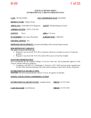
SITE PLAN REVIEW SHEET ENVIRONMENTAL VARIANCE REQUEST ONLY ZAP COMMISSION DATE: 02/18/2020 CASE: SP-2019-0189D PROJECT NAME: XSpace Group APPLICANT: Garett-Ihnen Civil Engineers AGENT: Michelle Rogerson Lynch ADDRESS OF SITE: 4229 N. F.M. 620 COUNTY: WATERSHED: Lake Austin Watershed EXISTING ZONING: N/a PROPOSED DEVELOPMENT: Commercial building with associated improvements DESCRIPTION OF VARIANCE: The applicant requests the following: JURISDICTION: 2-Mile ETJ AREA: 5.42 acres Travis 1. Request to vary from LDC 25-8-301 to construct a driveway on slopes in excess of 15 percent gradient. 2. Request to vary from LDC 25-8-342 to allow fill in excess of four feet of depth. STAFF RECOMMENDATION: Staff recommends that the required findings of fact have been met, and recommends approval of the variance with the following conditions: 1. Compliance with LDC 25-2, Subchapter C, Division 3, §25-2-1024 and restore the vegetated area in front of the structural retaining walls with a dense massing of native trees, shrubs, and grasses. ENVIRONMENTAL BOARD ACTION: 02/05/2020: The Environmental Board voted in (7) favor, (0) against, (0) absentia ZONING AND PLATTING COMMISSION ACTION: ENVIRONMENTAL REVIEW STAFF: Jonathan Garner CASE MANAGER: Ann DeSanctis PHONE: 512-974-1665 PHONE: 512-974-3102 1 of 33B-05 ENVIRONMENTAL COMMISSION MOTION 20200205 006a Date: February 5, 2020 Subject: XSpace Group, SP-2019-0189D Motion by: Katie Coyne Seconded by: Mary Ann Neely RATIONALE: WHEREAS, the Environmental Commission recognizes the applicant is requesting variances from: • LDC 25-8-301 to construct a driveway on slopes in excess of 15 percent gradient; and, • LDC 25-8-342 to allow fill in excess of four feet of depth. WHEREAS, the Environmental Commission recognizes that staff recommends the approval of this variance because the findings of fact have been met. THEREFORE, the Environmental Commission recommends approval of the requested variances listed above. For: Bedford, Creel, Nill, Guerrero, Coyne, Neely, and Gordon Against: None Abstain: None Recuse: Ramberg Absent: Smith, Thompson, and Maceo VOTE 7-0 Approved By: Linda Guerrero, Environmental Commission Chair 1 2 of 33B-05 Staff Findings of Fact Variance to LDC 25-8-301 3 of 33B-05 Development Services Department Staff Recommendations Concerning Required Findings Construction of a driveway on slopes in excess of 15 percent (LDC 25-8-301) Project Name: Ordinance Standard: Watershed Protection Ordinance Variance Request: XSpace Group SP-2019-0189D Include an explanation with each applicable finding of fact. A. Land Use Commission variance determinations from Chapter 25-8-41 of the City Code: 1. The requirement will deprive the applicant of a privilege available to owners of similarly …
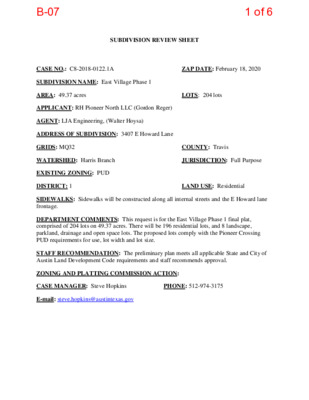
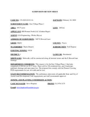
SUBDIVISION REVIEW SHEET CASE NO.: C8-2018-0122.1A ZAP DATE: February 18, 2020 SUBDIVISION NAME: East Village Phase 1 AREA: 49.37 acres LOTS: 204 lots APPLICANT: RH Pioneer North LLC (Gordon Reger) AGENT: LJA Engineering, (Walter Hoysa) ADDRESS OF SUBDIVISION: 3407 E Howard Lane GRIDS: MQ32 COUNTY: Travis WATERSHED: Harris Branch JURISDICTION: Full Purpose EXISTING ZONING: PUD DISTRICT: 1 LAND USE: Residential SIDEWALKS: Sidewalks will be constructed along all internal streets and the E Howard lane frontage. DEPARTMENT COMMENTS: This request is for the East Village Phase 1 final plat, comprised of 204 lots on 49.37 acres. There will be 196 residential lots, and 8 landscape, parkland, drainage and open space lots. The proposed lots comply with the Pioneer Crossing PUD requirements for use, lot width and lot size. STAFF RECOMMENDATION: The preliminary plan meets all applicable State and City of Austin Land Development Code requirements and staff recommends approval. ZONING AND PLATTING COMMISSION ACTION: CASE MANAGER: Steve Hopkins PHONE: 512-974-3175 E-mail: steve.hopkins@austintexas.gov 1 of 6B-06 EASTVILLAGE SINGLE FAMILY PHASE 1 Street, Drainage, Water and Wastewater Improvements E H O W A R D L A N E D A O R U ESSA D N PROJECT LOCATION 2 T O L 3 T O L 4 T O L 3 T O L E H O W A R D L A N E P A R M E R L A N E A5511005 CV1.dgn Default 4/30/2019 12:49:13 PM EASTVILLAGE SINGLE FAMILY 3124-1/2 E PARMER LN LOCATION MAP (N.T.S.) 2 of 6B-06 3 of 6B-06 4 of 6B-06 5 of 6B-06 6 of 6B-06
SUBDIVISION REVIEW SHEET CASE NO.: C8-2018-0122.1A ZAP DATE: February 18, 2020 SUBDIVISION NAME: East Village Phase 1 AREA: 49.37 acres LOTS: 204 lots APPLICANT: RH Pioneer North LLC (Gordon Reger) AGENT: LJA Engineering, (Walter Hoysa) ADDRESS OF SUBDIVISION: 3407 E Howard Lane GRIDS: MQ32 COUNTY: Travis WATERSHED: Harris Branch JURISDICTION: Full Purpose EXISTING ZONING: PUD DISTRICT: 1 LAND USE: Residential SIDEWALKS: Sidewalks will be constructed along all internal streets and the E Howard lane frontage. DEPARTMENT COMMENTS: This request is for the East Village Phase 1 final plat, comprised of 204 lots on 49.37 acres. There will be 196 residential lots, and 8 landscape, parkland, drainage and open space lots. The proposed lots comply with the Pioneer Crossing PUD requirements for use, lot width and lot size. STAFF RECOMMENDATION: The preliminary plan meets all applicable State and City of Austin Land Development Code requirements and staff recommends approval. ZONING AND PLATTING COMMISSION ACTION: CASE MANAGER: Steve Hopkins PHONE: 512-974-3175 E-mail: steve.hopkins@austintexas.gov 1 of 6B-07 EASTVILLAGE SINGLE FAMILY PHASE 1 Street, Drainage, Water and Wastewater Improvements E H O W A R D L A N E D A O R U ESSA D N PROJECT LOCATION 2 T O L 3 T O L 4 T O L 3 T O L E H O W A R D L A N E P A R M E R L A N E A5511005 CV1.dgn Default 4/30/2019 12:49:13 PM EASTVILLAGE SINGLE FAMILY 3124-1/2 E PARMER LN LOCATION MAP (N.T.S.) 2 of 6B-07 3 of 6B-07 4 of 6B-07 5 of 6B-07 6 of 6B-07
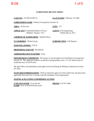
SUBDIVISION REVIEW SHEET LOTS: 137 (Matthew Trenner, V.P.) AGENT: LJA Engineering JURISDICTION: Full Purpose Z.A.P. DATES: February 18, 2020 (Walter Hoysa, P.E.) CASE NO.: C8-2016-0109.7A SUBDIVISION NAME: Pioneer Crossing East Section 18 AREA: 26.59 acres APPLICANT: Continental Homes of Texas ADDRESS OF SUBDIVISION: Sprinkle Road WATERSHED: Walnut Creek EXISTING ZONING: P.U.D. PROPOSED LAND USE: Residential ADMINISTRATIVE WAIVERS: None DEPARTMENT COMMENTS: The request is for the approval of the Pioneer Crossing East Section 18. The applicant proposes to plat the existing property into a 137 lot subdivision for residential uses on 26.59 acres. The plat follows the preliminary plan approved by the Zoning & Platting Commission on June 28, 2016. STAFF RECOMMENDATION: Staff recommends approval of the subdivision, the plat meets applicable State and City of Austin Land Development Code requirements. ZONING & PLATTING COMMISSION ACTION: CASE MANAGER: Cesar Zavala E-mail: cesar.zavala@austintexas.gov PHONE: 512-974-3404 1 of 5B-08 2 of 5B-08 LAND USE SUMMARY: PIONEER CROSSING EAST SECTION 18 TOTAL ACREAGE: STANDARD RESIDENTIAL DENSITY: LOTS: 26.59 ACRES 132 LOTS 4.96 UNITS PER ACRE NUMBER OF BLOCKS: 6 BLOCKS TOTAL LOTS: 137 OTHER LOTS: LS/PUE/PAE OS/LS OS/DE/PUE/PAE 2 LOTS (0.3700 ACRES) 1 LOT (0.1688 ACRES) 2 LOTS (0.0891 ACRES) TOTAL OTHER LOTS: 5 LOTS (0.6279 ACRES) SUBMITTAL DA TE: JUNE 22, 2017 PUBLIC STREET NAME LENGTH ROW WIDTH CUT OFF ROAD SPRINKLE CAPTAIN DIMMITT WAY DEFENDER TRAIL GONZALES RANGER PASS SEGUIN STREET ALAMO HEIGHTS A VENUE TOTAL 522' 209' 1203' 960' 529' 1129' 4542' 60' 50' 50' 50' 50' 50' DIRECTIONAL CONTROL AND HORIZONTAL COORDINATES BASIS: TEXAS CENTRAL ZONE 4203, DERIVED FROM THE NATIONAL GEODETIC SURVEY ON-LINE POSITIONING USER SERVICE (OPUS) USING STATIC GPS PROCEDURES, GRID TO SURFACE AND WERE SCALED FROM POINT NO. 1 (N:10104718.83, WITH A SCALE FACTOR = 1.0000822572. E:3143999. 85), LEGEND e 1/2" REBAR FOUND � ALUMINUM CAP FOUND 0 · · · · · · · · · · 1/2" REBAR W/CAP STAMPLED "LANDESIGN" SET SIDEWALK R.P.R. T.C. T. REAL PROPERTY RECORDS OF TRAVIS COUNTY, TEXAS O.P.R. T.C. T. D.E. DRAINAGE EASEMENT P.U.E.PUBLIC UTILITY EASEMENT W.Q.E.WATER QUALITY EASEMENT P.A.E. PUBLIC ACCESS EASEMENT L.S. LANDSCAPE o.s. LOT 12 BLOCK LL PIONEER CROSSING EAST SECTION 16 DOC. NO. 201700050 O.P.R. T.C. T. '\ '\ '\ '\ '\ "' / / r--. i---- 1 / / ,1 / I / / / / / / / VICINITY MAP (NOT TO SCALE) SCALE IN FEET 100 50 0 LOT 1 TROUPE ADDITION …
MEMORANDUM Pioneer Crossing PUD Amendment #14, Case C814-96-0003.14 ************************************************************************ TO: Zoning and Platting Commission Members FROM: Sherri Sirwaitis Planning and Zoning Department DATE: February 4, 2020 RE: ************************************************************************ The Pioneer Crossing Planned Unit Development (PUD) was approved by Council in 1997. On October 17, 2019, the City Council approved the 14th amendment to the PUD through Ordinance No. 20191017-064. The 14th amendment inadvertently omitted the following language in Part 7(C)(6) of the original PUD ordinance: [or those improvements that may be otherwise required by the City of Austin or specifically authorized under this ordinance.] The accidental omission of this language limits the types of improvements the City may require near an open waterway with upstream drainage. Therefore, an item has been placed on your agenda for consideration to initiate a new PUD amendment case to rezone the property to reinsert that language. 1 of 1C-01
MEMORANDUM ************************************************************************ TO: Ms. Jolene Kiolbassa, Chair Members of the Zoning and Platting Commission FROM: Wendy Rhoades, Principal Planner, Zoning Case Management Planning and Zoning Department DATE: February 12, 2020 RE: Request initiation of a zoning change for the property located at the west side of South Pleasant Valley Road near the intersection of Springville Lane ************************************************************************ The item under discussion is a request to consider directing Staff to initiate a rezoning case from P to SF-2, and from SF-4A-CO to P, associated with C14-2017-0043 – Onion Creek Greenbelt. The rezoning case would correct mapping errors in Ordinance No. 20170615-094 for the property located at the west side of South Pleasant Valley Road near the intersection of Springville Lane. In March 2017, a rezoning case was initiated by Council and filed by the Parks and Recreation Department requesting public (P) district zoning consistent with its greenbelt use and to facilitate development of a portion of the property with trails. The rezoning application included an accurate metes and bounds description, however, the rezoning map inadvertently included 7203 Deep Lane and rezoned this privately owned SF-2 zoned property to the P, Public district. In addition, the map did not include a SF-4A-CO zoned triangular area at the terminus of Deep Lane and extending east to unbuilt Meadow Lake Boulevard right-of-way that is also under the stewardship of PARD. In late-January 2020, the owner of 7203 Deep Lane inquired with Staff about the P district zoning assigned to her property. In response, Staff re-mapped the 2017 metes and bounds description and concluded that it correctly captured the City-owned property, but incorrectly mapped 7203 Deep Lane to the P district. The zoning map also incorrectly 1 of 10C-02 excluded the SF-4A-CO zoned triangular area. A City-initiated rezoning application would correct both errors. Attachments: Illustration of Proposed Mapping Errors to be Corrected 2017 Rezoning Ordinance 2 of 10C-02 ( ( (( (( ( S L LA ( ( B M ( ( ( ( ( ( ( ( ( ( ( ( ( ( SF-3 ( ( N ( ( ( ( ( ( SF-3 ( ( F ( ( ( ( (( ( ( ( SF-3 AVALO (( ( ( N AVE ( ( SF-3 SF-3 O N T E N A Y D R E CT LOIR SF-3 S R ( ( U N ( ( ( ( A D O W L …
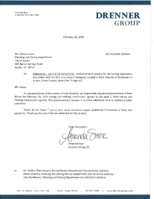
ZONING CHANGE REVIEW SHEET CASE: C14-2019-0159 (Arboretum Lot 9) DISTRICT: 10 ADDRESS: 9401 Arboretum Boulevard ZONING FROM: GR, CS, CS-1 TO: GR-MU SITE AREA: 15.20 acres (662,112 sq. ft.) PROPERTY OWNER: GF-ARB C, Ltd. % Live Oak Gottesman AGENT: Drenner Group, PC (Amanda Swor) CASE MANAGER: Sherri Sirwaitis (512-974-3057, sherri.sirwaitis@austintexas.gov) STAFF RECOMMENDATION: Staff recommends GR-MU, Community Commercial-Mixed Use Combining District, zoning. ZONING AND PLATTING COMMISSION ACTION / RECOMMENDATION: February 4, 2020: Postponed to February 18, 2020 at the applicant's request by consent (9-0, J. Kiolbassa-absent); H. Smith-1st, N. Barrera-Ramirez-2nd. February 18, 2020 CITY COUNCIL ACTION: February 20, 2020 ORDINANCE NUMBER: B-091 of 33 C14-2019-0159 2 ISSUES: N/A CASE MANAGER COMMENTS: The site under consideration is a 15+ acre property located at the northwest corner of North Capital of Texas Highway and Arboretum Boulevard. The property is currently an undeveloped parcel within a retail center, adjacent to a detention pond and a parking garage. The applicant is requesting a rezoning of the property from GR, CS and CS-1 zoning to GR- MU zoning to allow for mixed use development. The staff recommends GR-MU zoning for the property in question as it meets the intent of the Community Commercial-Mixed Use Combining District. This tract of land is surrounded by commercial uses/zoning to the north, east, and west. The property fronts and takes access to an arterial roadway, Arboretum Boulevard and a state highway, North Capital of Texas Highway. Site is located on an Activity Corridor, the Arboretum Boulevard Activity Corridor, as designated in the Imagine Austin Comprehensive Plan. The applicant agrees with the staff’s recommendation. BASIS OF RECOMMENDATION: 1. The proposed zoning should be consistent with the purpose statement of the district sought. Community Commercial district is intended for office and commercial uses serving neighborhood and community needs, including both unified shopping centers and individually developed commercial sites, and typically requiring locations accessible from major traffic ways. The purpose of a mixed use (MU) combining district is to allow office, retail, commercial, and residential uses to be combined in a single development. 2. The proposed zoning should promote consistency and orderly planning. The proposed GR-MU zoning would be compatible and consistent with the adjacent uses because this tract of land is surrounded by office and commercial uses/zoning to the north, south, east, and west. The property in question is located on an Activity Corridor, the Arboretum Boulevard Activity Corridor, as designated in …
ZONING & PLATTING COMMISSION AGENDA Tuesday, February 18, 2020 The Zoning and Platting Commission will convene at 6:00 PM on Tuesday, February 18, 2020 at Austin City Hall, Council Chambers 301 W. Second Street, Austin, TX Ana Aguirre – Secretary Nadia Barrera-Ramirez Timothy Bray Ann Denkler - Parliamentarian Jim Duncan – Vice-Chair Bruce Evans Jolene Kiolbassa – Chair David King Ellen Ray Hank Smith Vacant (District 4) EXECUTIVE SESSION (No public discussion) The Zoning & Platting Commission will announce it will go into Executive Session, if necessary, pursuant to Chapter 551 of the Texas Government Code, to receive advice from Legal Counsel on matters specifically listed on this agenda. The commission may not conduct a closed meeting without the approval of the city attorney. Private Consultation with Attorney – Section 551.071 CITIZEN COMMUNICATION The first four (4) speakers signed up prior to the meeting being called to order will each be allowed a three-minute allotment to address their concerns regarding items not posted on the agenda. A. APPROVAL OF MINUTES 1. Approval of minutes from February 4, 2020. Facilitator: Sylvia Limon, 512-974-2767 Attorney: Erika Lopez, 512-974-3588 Commission Liaison: Andrew Rivera, 512-974-6508 B. PUBLIC HEARINGS C14-2019-0118 - Champions Commercial Development; District 10 6025 North Capital of Texas Highway Northbound, Bull Creek Watershed 1. Rezoning: Location: Owner/Applicant: Champion Assets, Ltd. (William Clark Meier) Agent: Request: Staff Rec.: Staff: Kimley-Horn & Associates, Inc. (Joel Wixson, P.E.) GR-CO to GR-CO, to change a condition of zoning Request for Indefinite Postponement by Staff Wendy Rhoades, 512-974-7719 Planning and Zoning Department C14-2020-0001 - Colton Bluff Springs Road; District 2 6917 Colton Bluff Springs Road, Marble Creek Watershed 2. Rezoning: Location: Owner/Applicant: BMR Land LLC (William P. McLean) Agent: Request: Staff Rec.: Staff: McLean & Howard LLP (Jeffrey S. Howard) RR, SF-4A, SF-4A-CO and LR-MU to MF-3 (Tract 1), GR-MU (Tract 2) Recommended Kate Clark, 512-974-1237 Planning and Zoning Department C8-2018-0171.SH - Goodnight Ranch Phase Two - East; District 2 3. Preliminary Subdivision Plan: 9308 Capitol View Drive, Onion and Marble Creek Watersheds Location: Owner/Applicant: Austin Goodnight Ranch, L.P. (Myra Goepp) Agent: Request: Staff Rec.: Staff: Landdev Consulting (Greg Fortman) Approve a preliminary subdivision for 290 lots on 89.526 acres. Recommended Sylvia Limon, 512-974-2767 Ann DeSanctis, 512-974-3102 Development Services Department 4. Preliminary Subdivision Plan: Location: Owner/Applicant: Agent: Request: Staff Rec.: Staff: C8-2019-0057 - Pearson Ranch East Preliminary Plan; District 6 14320 North FM 620 Road Southbound, Lake …
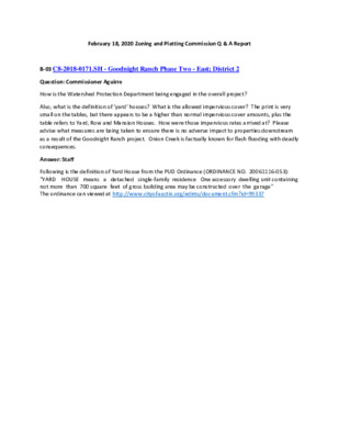
February 18, 2020 Zoning and Platting Commission Q & A Report B-03 C8-2018-0171.SH - Goodnight Ranch Phase Two - East; District 2 Question: Commissioner Aguirre How is the Watershed Protection Department being engaged in the overall project? Also, what is the definition of ‘yard‘ houses? What is the allowed impervious cover? The print is very small on the tables, but there appears to be a higher than normal impervious cover amounts, plus the table refers to Yard, Row and Mansion Houses. How were those impervious rates arrived at? Please advise what measures are being taken to ensure there is no adverse impact to properties downstream as a result of the Goodnight Ranch project. Onion Creek is factually known for flash flooding with deadly consequences. Answer: Staff Following is the definition of Yard House from the PUD Ordinance (ORDINANCE NO. 20061116-053): "YARD HOUSE means a detached single-family residence One accessory dwelling unit containing not more than 700 square feet of gross building area may be constructed over the garage" The ordinance can viewed at http://www.cityofaustin.org/edims/document.cfm?id=99337
SUBDIVISION REVIEW SHEET CASE NO.: C8-2018-0122.1A ZAP DATE: February 18, 2020 SUBDIVISION NAME: East Village Phase 1 AREA: 49.37 acres LOTS: 204 lots APPLICANT: RH Pioneer North LLC (Gordon Reger) AGENT: LJA Engineering, (Walter Hoysa) ADDRESS OF SUBDIVISION: 3407 E Howard Lane GRIDS: MQ32 COUNTY: Travis WATERSHED: Harris Branch JURISDICTION: Full Purpose EXISTING ZONING: PUD DISTRICT: 1 LAND USE: Residential SIDEWALKS: Sidewalks will be constructed along all internal streets and the E Howard lane frontage. DEPARTMENT COMMENTS: This request is for the East Village Phase 1 final plat, comprised of 204 lots on 49.37 acres. There will be 196 residential lots, and 8 landscape, parkland, drainage and open space lots. The proposed lots comply with the Pioneer Crossing PUD requirements for use, lot width and lot size. STAFF RECOMMENDATION: The preliminary plan meets all applicable State and City of Austin Land Development Code requirements and staff recommends approval. ZONING AND PLATTING COMMISSION ACTION: CASE MANAGER: Steve Hopkins PHONE: 512-974-3175 E-mail: steve.hopkins@austintexas.gov EASTVILLAGE SINGLE FAMILY PHASE 1 Street, Drainage, Water and Wastewater Improvements E H O W A R D L A N E D A O R U ESSA D N PROJECT LOCATION 2 T O L 3 T O L 4 T O L 3 T O L E H O W A R D L A N E P A R M E R L A N E A5511005 CV1.dgn Default 4/30/2019 12:49:13 PM EASTVILLAGE SINGLE FAMILY 3124-1/2 E PARMER LN LOCATION MAP (N.T.S.)
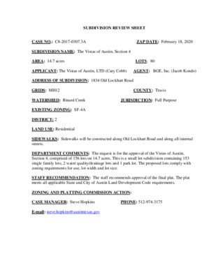
SUBDIVISION REVIEW SHEET CASE NO.: C8-2017-0307.3A SUBDIVISION NAME: The Vistas of Austin, Section 4 AREA: 14.7 acres APPLICANT: The Vistas of Austin, LTD (Cary Cobb) AGENT: BGE, Inc. (Jacob Kondo) ZAP DATE: February 18, 2020 LOTS: 80 COUNTY: Travis JURISDICTION: Full Purpose ADDRESS OF SUBDIVISION: 1834 Old Lockhart Road GRIDS: MH12 WATERSHED: Rinard Creek EXISTING ZONING: SF-4A DISTRICT: 2 LAND USE: Residential SIDEWALKS: Sidewalks will be constructed along Old Lockhart Road and along all internal streets. DEPARTMENT COMMENTS: The request is for the approval of the Vistas of Austin, Section 4, comprised of 156 lots on 14.7 acres. This is a small lot subdivision containing 153 single family lots, 2 water quality/drainage lots and 1 park lot. The proposed lots comply with zoning requirements for use, lot width and lot size. STAFF RECOMMENDATION: The staff recommends approval of the final plat. The plat meets all applicable State and City of Austin Land Development Code requirements. ZONING AND PLATTING COMMISSION ACTION: CASE MANAGER: Steve Hopkins E-mail: steve.hopkins@austintexas.gov PHONE: 512-974-3175 L J J Q R S T M M L R S Q Q T Q BGE, Inc. 101 West Louis Henna Blvd., Suite 400 Austin, TX 78728 Tel: 512-879-0400 ● www.bgeinc.com TBPE Registration No. F-1046 TBPLS Licensed Surveying Firm No. 10106502 Q Q T Q BGE, Inc. 101 West Louis Henna Blvd., Suite 400 Austin, TX 78728 Tel: 512-879-0400 ● www.bgeinc.com TBPE Registration No. F-1046 TBPLS Licensed Surveying Firm No. 10106502 BGE, Inc. 101 West Louis Henna Blvd., Suite 400 Austin, TX 78728 Tel: 512-879-0400 ● www.bgeinc.com TBPE Registration No. F-1046 TBPLS Licensed Surveying Firm No. 10106502 BGE, Inc. 101 West Louis Henna Blvd., Suite 400 Austin, TX 78728 Tel: 512-879-0400 ● www.bgeinc.com TBPE Registration No. F-1046 TBPLS Licensed Surveying Firm No. 10106502