Planning Commission: February 25, 2025 NEIGHBORHOOD PLAN AMENDMENT REVIEW SHEET NEIGHORHOOD PLAN: Rosewood CASE#: NPA-2024-0008.01 DATE FILED: June 21, 2024 PROJECT NAME: 2600 E Martin Luther King Jr. Blvd PC DATE: February 25, 2025 February 11, 2025 December 17, 2024 ADDRESS/ES: 2600 E Martin Luther King Jr Blvd DISTRICT AREA: 1 SITE AREA: 1.99 acres OWNER/APPLICANT: CTMS Holdings, LLC AGENT: Drenner Group, PC (Leah M. Bojo, AICP) CASE MANAGER: Maureen Meredith PHONE: (512) 974-2695 STAFF EMAIL: Maureen.Meredith@austintexas.gov TYPE OF AMENDMENT: Change in Future Land Use Designation From: Civic To: Mixed Use Base District Zoning Change Related Zoning Case: C14-2024-0111 From: GR-V-CO-NP To: GR-MU-V-DB90-NP NEIGHBORHOOD PLAN ADOPTION DATE: November 29, 2001 CITY COUNCIL DATE: TBD ACTION: 02 NPA-2024-0008.01 - 2600 E Martin Luther King Jr. Boulevard; District 11 of 36 Planning Commission: February 25, 2025 PLANNING COMMISSION RECOMMENDATION: February 25, 2025 – (action pending) February 11, 2025- Postponed to February 25, 2025 on the consent agenda at the request of Staff. [A. Azhar – 1st; F. Maxwell -2nd] Vote: 10 – 0 [P. Howard, A. Phillips and A. Haynes absent]. December 17, 2024 – Postponed to February 11, 2025 on the consent agenda at the request of the Applicant. [C. Haney – 1st; F. Maxwell – 2nd] Vote: 11-0 [N. Barrera-Ramirez and A. Phillips absent]. STAFF RECOMMENDATION: To support the applicant’s request for Mixed Use land use. BASIS FOR STAFF’S RECOMMENDATION: Staff supports the applicant’s request for Mixed Use land use because the property is located on Manor Road, which is an activity corridor where mixed use land use is appropriate. The property is within the MLK Station Neighborhood Center as identified on the Growth Concept Map and is less than ½-mile from the MLK Rail Station. The applicant proposes a 300-unit multifamily development with ground-floor retail. LAND USE DESCRIPTIONS: EXISTING LAND USE: Civic - Any site for public or semi fire facilities, hospitals, and public and private schools. Includes major religious facilities and other religious activities that are of a different type and scale than surrounding uses. Purpose 1. Allow flexibility in development for major, multi the greater community; 2. Manage the expansion of major institutional uses to prevent unnecessary impacts on established neighborhood areas; 3. Preserve the availability of sites for civic facilities to ensure that facilities are adequate for population growth; 4. Promote Civic uses that are accessible and useable for the neighborhood resident and maintain stability of …
ZONING CHANGE REVIEW SHEET CASE: C14-2024-0111 (2600 E. MLK Jr. Blvd.) DISTRICT: 1 ADDRESS: 2600 East Martin Luther King Jr. Boulevard ZONING FROM: GO-V-CO-NP TO: GR-MU-V-CO-DB90-NP (as amended) SITE AREA: approximately 1.99 acres (approximately 86,684 square feet) PROPERTY OWNER: CTMS Holdings, LLC AGENT: Drenner Group, PC (Leah Bojo) CASE MANAGER: Jonathan Tomko (512) 974-1057, jonathan.tomko@austintexas.gov STAFF RECOMMEDATION: Staff recommends granting community commercial-mixed use-vertical mixed use-conditional overlay-density bonus 90-neighborhood plan (GR-MU-V-CO-DB90-NP) combining district zoning. The conditional overlay would prohibit the following 15 uses: - Alternative Financial Services - Automotive Repair Services - Automotive Washing (of any type) - Commercial Off-Street Parking - Drop Off Recycling Facility - Funeral Services - Outdoor Entertainment - Service Station - Automotive Rentals - Automotive Sales - Bail Bond Services - Drive thru as an accessory use (to any use) - Exterminating Services - Hotel-Motel - Pawn Shop Services The conditional overlay would conditionally allow the following 5 uses: - Consumer Convenience Services - Indoor Entertainment - Offsite Accessory Parking - Hospital Services (limited) - Indoor Sports & Recreation For a summary of the basis of Staff’s recommendation, please see the basis of recommendation section below. PLANNING COMMISSION ACTION / RECOMMENDATION: December 17, 2024: Applicant postponement request to February 11, 2025, granted. February 11, 2025: Staff postponement request to February 25, 2025, granted. February 25, 2025: Case is scheduled to be heard by Planning Commission. CITY COUNCIL ACTION: TBD ORDINANCE NUMBER: TBD ISSUES: 03 C14-2024-0111 - 2600 E Martin Luther King Jr. Boulevard; District 11 of 21 C14-2024-0111 2 The applicant is proposing to remove an existing conditional overlay of 2,000 vehicle trips per day, prohibiting business or trade school, business support services, restaurant (limited), off-site accessory parking and personal services. In December 2023, Ordinance No. 20220609-080, Ordinance No. 20221201-056 and Ordinance No. 20221201-055 were invalidated. On March 11, 2024, Ordinance No. 20240229-073, was enacted to create the “DB90” combining district, which amended City Code Title 25 (Land Development) to create a new zoning district for a density bonus program that grants 30 feet in height above the base zoning district, to a maximum of 90 feet, and modifies site development regulations including compatibility standards. CASE MANAGER COMMENTS: The property in question is currently a vacant office/medical use, formerly used as the Capital Area Research and Radiation Center. It is approximately 16,000 square feet constructed in approximately 1972. The site also contains approximately 25,000 square feet …
Wooten Neighborhood Plan Contact Team February 20, 2025 Ms. Sherri Sirwaitis, Planner Principal Current Planning Division Planning Department City of Austin VIA Electronic Mail sherri.sirwaitis@austintexas.gov RE: 2100 Polaris - Rezoning City File Number C14-2024-0158 The Wooten Neighborhood Plan Contact Team(WNPCT) and the Applicant, SB-Polaris Property LLC, and its representatives engaged in a community outreach process to review the proposed rezoning. As of the WNPCT meeting on Monday, February 17th, the WNPCT supports the rezoning of the site located at 2100 Polaris based on the project meeting two goals. First, ensure the Redline Parkway Trail has the ability to pass along this site and is activated by the site. Second, we improve the walking and biking experience by reducing the quantity and impact of car traffic and improve bike and pedestrian infrastructure on nearby streets. To that end, the following will be implemented to meet the WNPCT’s and Applicant’s goals. 1. Ensure the Redline Parkway Trail has ability to pass along this site and is activated by the site. a. Enter into a restrictive covenant(or other legally binding agreement) that ensures the Redline Parkway Initiative, Cap Metro, and/or any other partners of the Reline Parkway Trail project have the easement and any other legal rights they need to build the trail at this location *A Restrictive Covenant will be entered into with Tom Wald with Red Line Trail organization to ensure that a twenty (20) foot easement will be dedicated for the future Red Line Trail. Tom Wald, Executive Director Red Line Parkway Initiative b. Activate the trail by: i. Ensuring trail is easily visible (physically or through way finding signage) from Polaris. *Agree to ensure the trail is easily visible through way finding signage from Polaris Avenue. 04 C14-2024-0158 - 2100 Polaris; District 41 of 5 ii. Not placing back of house functions along future trail and trail access routes. * Agree to hire local artist(s) to paint a mural on the garage side facing the trail at the height of a person on the trail a maximum of 15’. iii. Placing walk up units, preferable live/work, on the trail and trail access route. *Agree to provide units along the south side of the property facing the red line trail in the area on the south portion of the property as shown on the conceptual site plan below. Similar architectural design elements on the West side, facing the neighborhood and …
ZONING CHANGE REVIEW SHEET CASE: C14-2024-0158 (2100 Polaris) DISTRICT: 4 ZONING FROM: CS-CO-MU-NP TO: CS-MU-V-CO-DB90-NP ADDRESS: 2100 Polaris Avenue SITE AREA: 3.373 acres PROPERTY OWNER: SB-Polaris Property LLC (Zachary Greenky) AGENT: Land Use Solutions (Michele Haussmann) CASE MANAGER: Sherri Sirwaitis (512-974-3057, sherri.sirwaitis@austintexas.gov) STAFF RECOMMENDATION: Staff recommends CS-MU-V-CO-DB90-NP, General Commercial Services-Mixed Use- Vertical Mixed Use Building-Conditional Overlay-Density Bonus 90-Neighborhood Plan Combining District, zoning. The conditional overlay will maintain the following prohibited uses from the current zoning ordinance, Ordinance No. 20211021-039, on the property: Automotive repair services Automotive washing (of any type) Automotive rentals Automotive sales Bail bond services Commercial off-street parking Drop-off recycling collection facilities Equipment sales Outdoor entertainment Outdoor Sports and Recreation Commercial blood plasma center Construction sales and services Equipment repair services Exterminating services Maintenance and service facilities Pawn shop services Service station Vehicle storage Veterinary services February 25, 2025 CITY COUNCIL ACTION: ORDINANCE NUMBER: PLANNING COMMISSION ACTION / RECOMMENDATION: December 10, 2024: Postponed to January 28, 2025 at the applicant's request by consent (11-0, C. Haney-absent, G. Anderson-off dais); A. Azhar-1st, A. Woods-2nd. January 28, 2025: Postponed to February 25, 2025 at the applicant's request by consent (9-0, A. Phillips and A. Haynes - off dais, A. Woods and G. Anderson-absent); R. Johnson-1st, F. Maxwell-2nd. 04 C14-2024-0158 - 2100 Polaris; District 41 of 18 C14-2024-0158 ISSUES: 2 In December 2023, Ordinance No. 20220609-080, Ordinance No. 20221201-056 and Ordinance No. 20221201-055 were invalidated. On March 11, 2024, Ordinance No. 20240229-073, was enacted to create the “DB90” combining district, which amended City Code Title 25 (Land Development) to create a new zoning district for a density bonus program that grants 30 feet in height above the base zoning district, to a maximum of 90 feet, and modifies site development regulations including compatibility standards. Subsequently, the applicant submitted this new rezoning application to request the -DB90 combining district. CASE MANAGER COMMENTS: The property in question is a 3+ acre tract of land located at the terminus of Polaris Avenue. This currently vacant site was previously used as demolition company (Heart of Texas Demolition LLC). To the north, there are commercial and light industrial uses. The lot to the south is developed with a public school (Burnet Middle School). There is a rail line to the east. To the west, there are office/warehouse buildings to the north of Polaris Avenue and a multifamily complex, a townhouse residence, a duplex and single family …
PLANNING COMMISSION CONDITIONAL USE SITE PLAN SITE PLAN REVIEW SHEET CASE NUMBER: SPC-2024-0259C PC COMMISSION DATE: February 25, 2025 PROJECT NAME: CIP - Rosewood-Zaragosa Neighborhood Center Walkway ADDRESS: 2800 Webberville Rd DISTRICT: 1 NEIGHBORHOOD PLAN: Rosewood WATERSHED: Boggy Creek (Urban Watershed) AREA: 1.69 acres limits of construction APPLICANT: Sara Sallam, Project Manager City of Austin Building Services 2006 E 4th Street P.O. Box 1088 Austin, TX 78702 Ray Hardaway Lockwood, Andrews & Newnam, Inc. 8911 N. Capital Of Texas Hwy Building 2, Suite 2300 Austin, TX 78759 AGENT: CASE MANAGER: Meg Greenfield, (512) 978-4663 meg.greenfield@austintexas.gov EXISTING ZONING: P-NP PROPOSED USE: The applicant proposes to construct ADA-accessible parking, walkways, and ramp improvements at the existing Rosewood Zaragosa Neighborhood Center. No changes to the building are proposed (flatwork only). No increase to impervious cover is proposed. All site plan reviews are approved or informal status. REQUEST: This site is zoned P (Public) and is greater than one acre in size; therefore, a Conditional Use Permit is required, according to the Land Development Code {Section 25-2- 625}. WAIVER REQUEST: There are no waiver requests with this application. SUMMARY STAFF RECOMMENDATION: Approval. 05 SPC-2024-0259C - CIP - Rosewood-Zaragosa Neighborhood Center Walkway; District 11 of 21 SITE PLAN DETAILS: The site plan proposes the reduction of 7 parking spaces (6 standard, 1 accessible) to accommodate new walkways that will be established in conjunction with existing Accessible Parking Spaces. Additionally, two ramps are designed for construction: one situated at the West Entrance and the other at the Front Entrance. These proposed walkways and ramps are designed to meet the TAS Standards. SURROUNDING CONDITIONS: North: Single-family residential (SF-3-NP) East: Single-family residential (SF-3-NP) West: Park (P-NP) South: Single-family and Multi-family (SF-3-NP and MF-3-NP) NEIGHBORHOOD ORGANIZATION: Austin Independent School District Austin Lost and Found Pets Austin Neighborhoods Council Central Austin Concerned Architects Del Valle Community Coalition East Austin Conservancy El Concilio Mexican-American Neighborhoods Friends of Austin Neighborhoods Govalle/Johnston Terrace Neighborhood Plan Contact Team Homeless Neighborhood Association Neighborhood Empowerment Foundation Neighbors United for Progress, Overton Family Committee Preservation Austin, Red Line Parkway Initiative Rosewood Glen Oaks Neighborhood Association Rosewood Neighborhood Plan Contact Team SELTexas Save Our Springs Alliance Sierra Club Austin Regional Group 05 SPC-2024-0259C - CIP - Rosewood-Zaragosa Neighborhood Center Walkway; District 12 of 21 Property Profile Legend Appraisal Districts TCAD Parcels Review Cases Site Plan Review Cases (All) Zoning 1 Zoning CS GR LI MF NO P SF …
Affordability Impact Statement Colorado River Protection Ordinance Case number: C20-2022-025 Initiated by: Resolution No. 20220609-061 Date: 12/2/2024 Proposed Regulation The current Land Development Code’s Drainage Chapter mandates a 100-foot Erosion Hazard Zone (EHZ) along the Colorado River downstream of Lady Bird Lake. Due to the river’s bank heights and erosive force, this distance is insufficient for protecting buildings and infrastructure. The proposed ordinance seeks to expand the EHZ from 100 feet to 200 feet for new buildings and infrastructure. This expansion excludes hard-surfaced trails, which will retain the 100-foot requirement. Additionally, the proposed Drainage Criteria Manual (DCM) rules introduce standards for non-erosive stormwater outfalls in high-erosion areas, particularly where sandy soils are prevalent. 06 C20-2022-025 - Colorado River Protection1 of 3 Land Use/Zoning Impacts on Housing Costs The proposed EHZ expansion is anticipated to have a neutral impact on housing costs. Watershed Protection Department (WPD) staff have engaged with various stakeholders, including the Lower Colorado River Authority (LCRA), Travis County, Austin Water (AW), Transportation & Public Works (TPW), Parks & Recreation Department (PARD), Austin Energy (AE), community organization PODER, and developers currently undergoing permitting processes. Development stakeholders noted the 200-foot EHZ aligns with the setback under existing Critical Water Quality Zone buffers, thus minimizing development footprint impacts. Additionally, stakeholders PARD and TPW, along with developers, requested that hard-surfaced trails remain under the 100-foot requirement to prevent excessive costs, maintain the trails’ accessibility, and reduce the need for additional easement acquisitions. Impact on Development Cost The proposed changes would have minimal impacts on development cost. Financial impacts will vary by project type and whether a project is new or a redevelopment. Parcels affected by this provision are limited to those along the 25.2 miles of Colorado River downstream of Lady Bird Lake, totaling under 360 parcels. This regulation would not apply to single-family construction in the ETJ, which accounts for 70 of the 360 parcels. For new subdivisions and site plans, the impact is minimal due to the existing minimum 200-foot buffer already restricting most development. Redevelopment site plans and single-family permits, however, could face increased foundation construction costs if building within the EHZ. Structural engineers have estimated potential cost increases of 3-5 times for foundations requiring deeper subsurface anchoring and additional protections against erosion. Developers may opt to relocate structures outside the EHZ to avoid these additional costs. Although developments may increase foundation and erosion protection costs for structures in …
Overview of the Colorado River Protections Ordinance P l a n n i n g C o m m i s s i o n J a n u a r y 2 8 , 2 0 2 4 C I T Y O F A U S T I N W A T E R S H E D P R O T E C T I O N D E P A R T M E N T 06 C20-2022-025 - Colorado River Protection1 of 23 2-Minute Summary Video C I T Y O F A U S T I N W A T E R S H E D P R O T E C T I O N D E P A R T M E N T 2 Youtube video link 06 C20-2022-025 - Colorado River Protection2 of 23 The Colorado River • Crucial Resource • Significant Erosion • Water Quality Better Protected • Needs careful management • Dynamic natural system C I T Y O F A U S T I N W A T E R S H E D P R O T E C T I O N D E P A R T M E N T 3 06 C20-2022-025 - Colorado River Protection3 of 23 Council Resolution Community members asked Council to strengthen Colorado River protections; Council thereafter included in their June 2022 Council resolution: “… evaluate the effectiveness of existing Critical Water Quality Zone and Erosion Hazard Zone buffers on the Colorado River downstream of the Longhorn Dam and to propose protections that will provide adequate protections to the river that will ensure a healthy riparian corridor to stabilize the riverbank and protect property from erosion” C I T Y O F A U S T I N W A T E R S H E D P R O T E C T I O N D E P A R T M E N T 4 06 C20-2022-025 - Colorado River Protection4 of 23 The Proposal One simple change to the Land Development Code: Change Erosion Hazard Zone from 100 to 200 feet, downstream of Longhorn Dam Later (separate process): Improve drainage design rules to reduce extreme erosion C I T Y O F A U S T I N W A T E R S H E D P R O T E C T …
ORDINANCE AMENDMENT REVIEW SHEET Amendment: C20-2022-0025, Land Development Code Amendment to Title 25-7 Drainage Description: Consider an ordinance regarding amendments to Title 25 related to adequate protections to the Colorado River downstream of the Longhorn Dam. Proposed Language: To revise 25-7-32(B)(2) to establish the erosion hazard zone of the Colorado River downstream of the Longhorn Dam as 200 feet from the ordinary high-water mark, with exceptions for trails and bounded by public rights-of-way and only affecting new habitable structures and subsurface infrastructure. See Attachment A. Summary of proposed code changes: The proposed code change would expand the Erosion Hazard Zone (EHZ) associated with the Colorado River downstream of the Longhorn Dam to 200 feet from the ordinary high-water mark (federally defined edge of river bank). The existing EHZ is measured 100 feet from the ordinary high-water mark. The EHZ would only apply to new habitable structures (e.g., residential houses) and infrastructure (e.g., new roadways, water and wastewater pipes) and NOT to existing structures and infrastructure or to new sheds, pools, patios, decks, fences, and the like. Staff are proposing that EHZ requirements for hard-surfaced trails remain at 100 feet. The EHZ would also not extend past existing public rights-of-way. Thus, for example, a property on the far side of a public roadway from river would not be subject to the EHZ. Additionally, single-family residential construction in the Extra Territorial Jurisdiction would not be affected by this ordinance since Travis County, not the City of Austin, regulates such construction. Staff heard from multiple single-family property owners along Red Bluff Rd. concerned about the significant impacts of the ordinance on their properties. Staff are sympathetic to these concerns. Staff’s main focus is on larger infrastructure (roads, water and wastewater lines, etc.) and commercial and multifamily projects that might build too close to the river without sufficient consideration of erosion protections. Staff are less focused on individual single-family projects (which already do have the existing 100-foot erosion hazard requirement)—although it is important for all to understand the risks of building on high, sandy-soil river banks. After presenting the proposed ordinance to the Austin Contractors and Engineers Association, one suggestion that resulted from that discussion is to amend the code to allow for an administrative variance to LDC 25-8-341 to allow for cut and fill greater than four feet as minimally necessary to allow for grading resulting from protective works. Staff are in support …
Austin Core Transportation (ACT) Plan Small Area Mobility Plan of the ASMP: Downtown Austin Planning Commission Briefing – February 25, 2025 Agenda • ACT Plan Purpose and Background • Planning Process • ACT Plan Project Recommendations • Implementation Plan • Next Steps 2 ACT Plan Purpose • The ACT Plan is a Small Area Mobility Plan covering Downtown Austin and will be adopted by Council as an attachment to the ASMP. • It is an update to previous transportation focused efforts Downtown – dating back to 2000 • Why are we updating the transportation plan for Downtown? • changes in transit and bicycle planning, • changes in highway improvements serving Downtown, • changes in national best practices on urban street design, and • disruptions to traditional mobility • The ACT Plan will create a unified vision for transportation Downtown and align the many projects and initiatives under one actionable plan to help accomplish the goals in the Austin Strategic Mobility Plan. 3 Background • Great Streets Master Plan, 2001 • The goal of the Great Streets program is to pursue the vision of streets for people • Downtown Access and Mobility Plan, 2002 • The emphasis of the access and mobility study was on modeling and simulating intersection traffic operations and determining existing and future levels-of- service and operational needs • Downtown Transportation Framework, 2008 • The Downtown Transportation Framework Plan builds on the Great Streets Master Plan, further developing the system of “priority streets by mode”, and developing more detailed streetscape cross sections of all of the different street types and variations • Downtown Austin Plan, 2011 • Established the vision to develop a multimodal transportation system that improves access to and mobility within Downtown 2001 2002 2008 2011 4 Background • New policy • The Austin Strategic Mobility Plan (ASMP) aspires to achieve a 50/50 mode share where 50% of commuters use means other than driving alone to get to work in 2039 • Transit planning • The Project Connect Long Term Vision Plan established a High-Capacity Transit System and was adopted as an element of the ASMP – an initial investment was funded in 2020 • Managing demand • Transportation Demand Management programming, parking policy, and curb management are becoming critical strategies to manage congestion • New street design • The Congress Avenue Urban Design Initiative shows how to reimagine the allocation of space • Many new …
PLANNING COMMISSION REGULAR CALLED MEETING FEBRUARY 11, 2025 The Planning Commission convened in a regular meeting on Tuesday, February 11, 2025, at Austin City Hall, Council Chambers, Room 1001, 301 W. Second Street, in Austin, Texas. Chair Hempel called the Planning Commission Meeting to order at 6:04 p.m. Board Members/Commissioners in Attendance: Claire Hempel Awais Azhar Casey Haney Felicity Maxwell Danielle Skidmore Board Members/Commissioners in Attendance Remotely: Greg Anderson Nadia Barrera-Ramirez Grayson Cox Ryan Johnson Alice Woods Board Members/Commissioners absent: Adam Haynes Patrick Howard Alberta Phillips Ex-Officio Members in Attendance: Jessica Cohen Ex-Officio Members remote: Candace Hunter PUBLIC COMMUNICATION: GENERAL 1 Angela Benavides Garza: Issues about not knowing about the meeting in the community, and the company name Expedia Group is on Lobbyist page Santiago: Historic overlay APPROVAL OF MINUTES 1. Approve the minutes of the Planning Commission REGULAR MEETING on January 14, 2025, and January 28, 2025 The public hearing was closed on Commissioner Maxwell’s motion, Vice Chair Azhar’s second, on a 10-0 vote. Commissioner Anderson was off the dais. Commissioners Haynes, Howard, and Phillips were absent. The minutes from the meeting of January 14, 2025, and January 28, 2025, were approved on the consent agenda on Vice Chair Azhar’s motion, Commissioner Maxwell’s second, on a 10-0 vote. Commissioners Haynes, Howard, and Phillips were absent. PUBLIC HEARINGS 2. Plan Amendment: NPA-2024-0008.01 - 2600 E Martin Luther King Jr. Boulevard; Location: District 1 2600 East Martin Luther King Jr. Boulevard, Boggy Creek Watershed; Rosewood Neighborhood Planning Area Owner/Applicant: CTMS Holdings LLC Agent: Request: Staff Rec.: Staff: Drenner Group, PC (Leah M. Bojo, AICP) Civic to Mixed Use land use Staff postponement request to February 25, 2025 Maureen Meredith, 512-974-2695, maureen.meredith@austintexas.gov Planning Department The motion to approve Staff’s postponement request to February 25, 2025, was approved on the consent agenda on Vice Chair Azhar’s motion, Commissioner Maxwell’s second, on a 10-0 vote. Commissioners Haynes, Howard, and Phillips were absent. 3. Rezoning: Location: C14-2024-0111 - 2600 E Martin Luther King Jr. Boulevard; District 1 2600 East Martin Luther King Jr. Boulevard, Boggy Creek Watershed; Rosewood Neighborhood Planning Area Owner/Applicant: CTMS Holdings LLC Agent: Request: Staff Rec.: Staff: Drenner Group, PC (Leah M. Bojo) GO-V-CO-NP to GR-MU-V-DB90-NP Staff postponement request to February 25, 2025 Jonathan Tomko, 512-974-1057, jonathan.tomko@austintexas.gov Planning Department The motion to approve Staff’s postponement request to February 25, 2025, was approved on the consent agenda on Vice Chair Azhar’s motion, Commissioner …
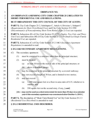
Planning Commission Amendment Tracking 17 C20-2024-014 - STR Modifications (Hempel, Azhar) Base Motion: Staff recommendation – passes 9-0-1 (Commissioner Cox abstained) (Maxwell 1, Haney) – A requirement that the provisions of the ordinance be reviewed in a report from the Development Services Department in a 12-month timeframe subsequent to enactment - Passes unanimously (Azhar 1, Cox) – Passes unanimously (Commissioner Anderson was off the dais) Language: Revise § 4-23-3X - Eligibility to Operate a Short-Term Rental to include the text below as follows: • On a site with more than four but less than 51 dwelling units, an owner may operate at least one • On a site with more than 50 but less than 101 dwelling units, an owner may operate at least one • On a site with more than 100 but less than 251 dwelling units, an owner may operate at least one • On a site with more than 250 dwelling units, an owner may operate at least one but no more than but no more than 20% of the units but no more than 10% of the units but no more than 5% of the units 3% of the units (Hempel 1, Cox) (substituted so does not pass): If there is a nuisance that involves a criminal activity an owner cannot operate an STR at that location or any other location in perpetuity or a considerable amount of time, subject to legal review, until there is a change of ownership at that property. Substitute Hempel 1: (Cox, failed due to lack of a second): Instead of the owner being banned from operating an STR, the physical property is banned from continuing to be an STR. Substitute to Hempel 1: (Barrera-Ramirez, Johnson) – Passes unanimously If there are three or more nuisance activities that involve a violent criminal activity at a unit, an owner cannot operate an STR in a unit in perpetuity or a considerable amount of time, subject to legal review, until there is a change of ownership of the unit. (Woods 1, Maxwell) – Passes unanimously General recommendation to staff to consider establishing a single city phone number for STR complaints/compliance issues, not to replace 911, and establish a system to first route those calls to the local contact for the STR before routing them to compliance staff. (Cox 1, Azhar) – Passes unanimously (Commissioner Anderson was off the dais) Direct staff to …
AUSTIN FIRE DEPARTMENT 2024 International Wildland Urban Interface Code Adoption Coordinate and Clarify Goals: Clarify previously adopted local amendments with changing technology and published code. Adjust requirements based on challenges and successes of initial implementation of the International Wildland-Urban Interface Code (WUI). Reasons for amendments: 1. To support operating procedures for Wildfire Operations. 2. Formalize WUI Proximity Zones to clarify structure hardening requirements. 3. Align requirements with current wildfire research. 4. Clarification purposes and formalizing 2015 WUIC interpretations. 2 2024 WUI Highlights Clarifications • Formalize allowances and interpretations • Increased use of the Fire Protection Criteria Manual • Added reference alignment to the Fire Code • Extreme Hazard Condition clarified • Fire Hazard Severity Form (amended) required for • Development under City of Austin Homes Options for Mobility and Equity initiatives • Where a single fire apparatus access road serves more than 30 dwelling units • Wildland definition clarified • Compliance with roof fire-rating • No wood or green roof coverings • Raised-deck systems to comply with International Building Code (IBC) • Exterior ceilings, same treatment as soffits • Artificial turf requirements provided 3 2024 WUI Highlights Changes • Unofficial “Proximity Classes” defined and renamed Proximity Zones A, B, and C • Zone A & B modified protection of accessory structures • Zone B enhanced protection of walls • Zone C enhanced eave and ceiling protection • Zone C reduced roofing, underfloor enclosure, and slope requirements • NEW Ember Ignition Zone • Expiration of initial code launch leniency • Reduced full roof replacement requirement • Reduced boat dock requirements • Driveways, 202 Definitions, 403.2, 403.2.3 • Required for Residential* buildings >150’ from fire apparatus access road where a new fire lane is not otherwise provided • Group Residential* buildings >200’ from fire apparatus access road require a new fire lane or may provide a driveway and automatic fire sprinklers • Serve up to three buildings and three dwelling units max, otherwise a Fire Lane is required *Residential buildings defined as R-3 occupancy in the IBC/IFC 4 Post-Engagement Update 2024 WUI Map Proximity Zones: Zone A: Within 50’ of 40 acre+ wildland Zone B: Within 150’ of 40 acre+ wildland Zone C: • Within 1.5 miles of 750 acre+ wildland • Within 0.5 miles of 40 acre+ wildland (new) Legend: Green/Dark Blue = Wildland & Proximity Zones A & B Light Blue = Proximity Zone C New map shows “offsets” or …
PLANNING COMMISSION REGULAR MEETING TUESDAY, FEBRUARY 25, 2025 The Planning Commission convened in a regular meeting on Tuesday, February 25, 2025, at Austin City Hall, Council Chambers, Room 1001, 301 W. Second Street, in Austin, Texas. Vice Chair Azhar called the Planning Commission meeting to order at 6:04 p.m. Commissioners in Attendance: Awais Azhar Greg Anderson Grayson Cox Felicity Maxwell Casey Haney Danielle Skidmore Alice Woods Commissioners in Attendance Remotely: Nadia Barrera-Ramirez Patrick Howard Ryan Johnson Commissioners Absent: Claire Hempel Adam Haynes Alberta Phillips Ex-officio Members in Attendance: Jessica Cohen Ex-officio Members in Attendance Remotely: Candace Hunter Ex-officio Members Absent: 1 TC Broadnax Richard Mendoza PUBLIC COMMUNICATION: GENERAL None. APPROVAL OF MINUTES 1. Approve the minutes of the Planning Commission regular meeting on Tuesday, February 11, 2025. The minutes from the meeting of Tuesday, February 11, 2025, were approved on the consent agenda on Commissioner Haney’s motion, Commissioner Maxwell’s second, on an 8-0 vote. Commissioners Cox and Johnson were off the dais. Chair Hempel and Commissioners Haynes and Phillips were absent. PUBLIC HEARINGS 2. Plan Amendment: NPA-2024-0008.01 - 2600 E Martin Luther King Jr. Boulevard; Location: District 1 2600 East Martin Luther King Jr. Boulevard, Boggy Creek Watershed; Rosewood Neighborhood Planning Area Owner/Applicant: CTMS Holdings LLC Agent: Request: Staff Rec.: Staff: Drenner Group, PC (Leah M. Bojo, AICP) Civic to Mixed Use land use Recommended Maureen Meredith, 512-974-2695, maureen.meredith@austintexas.gov Planning Department The motion to approve Staff’s recommendation of Mixed Use land use for NPA-2024- 0008.01 - 2600 E Martin Luther King Jr. Boulevard, located at 2600 East Martin Luther King Jr. Boulevard, was approved on the consent agenda on Commissioner Haney’s motion, Commissioner Maxwell’s second, on an 8-0 vote. Commissioners Cox and Johnson were off the dais. Chair Hempel and Commissioners Haynes and Phillips were absent. 3. Rezoning: Location: C14-2024-0111 - 2600 E Martin Luther King Jr. Boulevard; District 1 2600 East Martin Luther King Jr. Boulevard, Boggy Creek Watershed; Rosewood Neighborhood Planning Area Owner/Applicant: CTMS Holdings LLC Agent: Request: Staff Rec.: Staff: Drenner Group, PC (Leah M. Bojo) GO-V-CO-NP to GR-MU-V-CO-DB90-NP Recommended Jonathan Tomko, 512-974-1057, jonathan.tomko@austintexas.gov Planning Department The motion to approve Staff’s recommendation of GR-MU-V-CO-DB90-NP for C14- 2024-0111 - 2600 E Martin Luther King Jr. Boulevard, located at 2600 East Martin 2 Luther King Jr. Boulevard, was approved on the consent agenda on Commissioner Haney’s motion, Commissioner Maxwell’s second, on an 8-0 vote. Commissioners Cox and Johnson were …
REGULAR MEETING of the PLANNING COMMISSION TUESDAY, FEBRUARY 11, 2025, 6:00 PM AUSTIN CITY HALL, COUNCIL CHAMBERS, ROOM 1001 301 WEST 2ND STREET AUSTIN, TEXAS Some members of the Planning Commission may be participating by videoconference. The meeting may be viewed online at: http://www.austintexas.gov/page/watch-atxn-live. Public comment will be allowed in-person or remotely via telephone. Speakers may only register to speak on an item once either in-person or remotely. Registration no later than 2 PM the day of the meeting is required for remote participation by telephone. For more information on public comment, please see the agenda section “Speaker Registration.” Please contact Ella Garcia, Staff Liaison, for questions regarding speaker registration at LandUseLiaison@austintexas.gov or by phone at 512-978-0821. CURRENT BOARD MEMBERS/COMMISSIONERS: Casey Haney (District 6) Ryan Johnson (District 7) Danielle Skidmore (District 9) Grayson Cox (District 10) Alberta Phillips (Mayor’s Representative) Adam Haynes (Holdover, Mayor’s Representative) Claire Hempel, Chair (District 8) Awais Azhar, Vice Chair (Mayor’s Representative) Greg Anderson, Secretary (District 4) Alice Woods, Parliamentarian (District 2) Patrick Howard (District 1) Nadia Barrera-Ramirez (District 3) Felicity Maxwell (District 5) EX-OFFICIO MEMBERS: EXECUTIVE SESSION (No public discussion) Executive Liaison: Joi Harden, 512-974-1617 Staff Liaison: Ella Garcia, 512-978-0821 Attorney: AJ Urteaga, 512-974-2386 Jessica Cohen, Chair of Board of Adjustment Candace Hunter, AISD Board of Trustees TC Broadnax, City Manager Richard Mendoza – Director of Transportation and Public Works The Planning Commission will announce it will go into Executive Session, if necessary, according to Chapter 551 of the Texas Government Code, to receive advice from Legal Counsel on matters specifically listed on the agenda. The Commission may not conduct a closed meeting without the approval of the city attorney. Private Consultation with Attorney – Section 551.071. CALL TO ORDER PUBLIC COMMUNICATION: GENERAL AGENDA The first four speakers signed up prior to the meeting being called to order will each be allowed a three-minute allotment to address their concerns regarding items not posted on the agenda. APPROVAL OF MINUTES 1. Approve the minutes of the Planning Commission regular meeting on January 14, 2025, and January 25, 2025. PUBLIC HEARINGS 2. Plan Amendment: NPA-2024-0008.01 - 2600 E Martin Luther King Jr. Boulevard; Location: District 1 2600 East Martin Luther King Jr. Boulevard, Boggy Creek Watershed; Rosewood Neighborhood Planning Area Owner/Applicant: CTMS Holdings LLC Agent: Request: Staff Rec.: Staff: Drenner Group, PC (Leah M. Bojo, AICP) Civic to Mixed Use land use Staff postponement request to February …
City of Austin Planning Department 6310 Wilhelmina Delco Drive, Austin, TX 78752 P.O. Box 1088, Austin, TX 78767 -1088 (512) 974-2000 ♦ h ttp s:/ / w w w.a u st in tex a s .g ov / d epa r tm e n t/ plan n in g - de part men t MEMORANDUM TO: FROM: Claire Hempel, Chair & Planning Commission Members Maureen Meredith, Senior Planner, Long-Range Planning Division Jonathan Tomko, Principal Planner, Current Planning Division Planning Department DATE: February 5, 2025 RE: NPA-2024-0008.01 and C14-2024-0111 2600 E. Martin Luther King, Jr. Blvd Staff requests a postponement of the above-referenced cases from the February 11, 2025 Planning Commission hearing date to the February 25, 2025 hearing date to allow staff additional time to review the applications. This postponement request was made in a timely manner and meets the Planning Commission’s policy. Attachments: Plan Amendment Map Zoning Map The City of Austin is committed to compliance with the Americans with Disabilities Act and will provide reasonable modifications and equal access to communications upon request. 02 and 03 NPA-2024-0008.01 and C14-2024-0111 2600 E Martin Luther King Jr. Boulevard; District 11 of 3 The City of Austin is committed to compliance with the Americans with Disabilities Act and will provide reasonable modifications and equal access to communications upon request. 02 and 03 NPA-2024-0008.01 and C14-2024-0111 2600 E Martin Luther King Jr. Boulevard; District 12 of 3 The City of Austin is committed to compliance with the Americans with Disabilities Act and will provide reasonable modifications and equal access to communications upon request. 02 and 03 NPA-2024-0008.01 and C14-2024-0111 2600 E Martin Luther King Jr. Boulevard; District 13 of 3
Via Electronic Delivery Re: Rezoning Application – 2967 Manor Road Revision – Rezoning C14-2024-0107 & NPA-2024-0008.02 We request postponement of these two cases from the Planning Commission’s agenda on 2/11/2025 to March 11, 2025, to allow additional time to engage with the neighborhood regarding concerns associated February 6, 2025 Mr. Jonathan Tomko Ms. Maureen Meredith City of Austin, Planning Department 6310 Wilhelmina Delco Drive Austin, TX 78752 Dear Jonathan & Maureen: with the rezoning. Kind regards, Victoria Haase P . O . B O X 4 1 9 5 7 , A U S T I N , T E X A S 7 8 7 0 4 1 5 0 7 I N G L E W O O D S T . , A U S T I N , T E X A S 7 8 7 4 1 04 and 05 NPA-2024-0008.02 and C14-2024-0107 Manor Road Revision Rezone; Districts 1 and 9 1 of 1
Planning Commission: February 11, 2025 NEIGHBORHOOD PLAN AMENDMENT REVIEW SHEET NEIGHBORHOOD PLAN: Rosewood Neighborhood Plan and the Martin Luther King Jr. Boulevard Transit Oriented Development (MLK TOD) Station Area Plan CASE#: NPA-2024-0008.02 DATE FILED: July 25, 2024 PROJECT NAME: 2967 Manor Road Revision PC DATE: February 11, 2025 January 28, 2025 January 14, 2025 ADDRESS/ES: 2967 Manor Road DISTRICT AREA: 1 and 9 SITE AREA: 0.68 acres (for parcel) OWNER/APPLICANT: 2967 Manor AGV, LLC AGENT: Thrower Design, LLC (Victoria Haase and Ron Thrower) CASE MANAGER: Maureen Meredith PHONE: (512) 974-2695 STAFF EMAIL: Maureen.Meredith@austintexas.gov TYPE OF AMENDMENT: Change in Future Land Use Designation From: Specific Regulating District To: Mixed Use Base District Zoning Change Related Zoning Case: C14-2024-0107 From: TOD-NP To: CS-DB90-NP NEIGHBORHOOD PLAN ADOPTION DATE: Rosewood Neighborhood Plan adopted January 10, 2002. Martin Luther King, Jr. Transit Oriented Development (TOD) Station Area Plan adopted March 12, 2009. CITY COUNCIL DATE: January 30, 2025 ACTION: Postponed to March 6, 2025 Page 1 of 32 04 NPA-2024-0008.02 - 2967 Manor Road Revision; Districts 1 and 91 of 32 Planning Commission: February 11, 2025 ACTION: (action pending) March 6, 2025 PLANNING COMMISSION RECOMMENDATION: February 11, 2025 – (action pending) January 28, 2025 – After postponement discussion, postponed to February 11, 2025 on the consent agenda at the request of the applicant. [F. Maxwell – 1st; A. Azhar – 2nd] Vote: 7-3 [G. Anderson and A. Woods absent. G. Cox, A. Haynes, and N. Barrera-Ramirez voted nay]. January 14, 2025 – Postponed to January 28, 2025 on the consent agenda at the request of staff. STAFF RECOMMENDATION: Staff supports the applicant’s request for Mixed Use land use and to be removed from the boundaries of the MLK TOD Station Area Plan. BASIS FOR STAFF’S RECOMMENDATION: Staff supports the applicant’s request for Mixed Use land use and for the property to be removed from the MLK TOD boundaries because the proposed rezoning will allow for a denser development that is more transit- supportive than could be achieved under the existing TOD-NP. The proposed rezoning would allow for approximately 81 housing units and 10 income restricted units, as opposed to 30 units with no income restricted units provided. The property is on the edge of the TOD boundaries and would not cause a “donut-hole” in the TOD area. The property is near public transportation along Manor Road (activity corridor), Airport Blvd (activity corridor) and E. MLK …
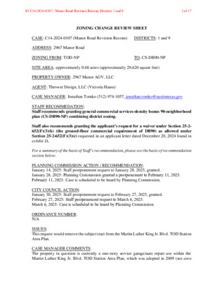
ZONING CHANGE REVIEW SHEET CASE: C14-2024-0107 (Manor Road Revision Rezone) DISTRICTS: 1 and 9 ADDRESS: 2967 Manor Road ZONING FROM: TOD-NP TO: CS-DB90-NP SITE AREA: approximately 0.68 acres (approximately 29,620 square feet) PROPERTY OWNER: 2967 Manor AGV, LLC AGENT: Thrower Design, LLC (Victoria Haase) CASE MANAGER: Jonathan Tomko (512) 974-1057, jonathan.tomko@austintexas.gov STAFF RECOMMEDATION: Staff recommends granting general commercial services-density bonus 90-neighborhood plan (CS-DB90-NP) combining district zoning. Staff also recommends granting the applicant’s request for a waiver under Section 25-2- 652(F)(3)(b) (the ground-floor commercial requirement of DB90) as allowed un der Section 25-2-652(F)(3)(e) requested in an applicant letter dated December 20, 2024 found in exhibit D. For a summary of the basis of Staff’s recommendation, please see the basis of recommendation section below. PLANNING COMMISSION ACTION / RECOMMENDATION: January 14, 2025: Staff postponement request to January 28, 2025, granted. January 28, 2025: Planning Commission granted a postponement to February 11, 2025. February 11, 2025: Case is scheduled to be heard by Planning Commission. CITY COUNCIL ACTION: January 30, 2025: Staff postponement request to February 27, 2025, granted. February 27, 2025: Staff postponement request to March 6, 2025. March 6, 2025: Case is scheduled to be heard by Planning Commission. ORDINANCE NUMBER: N/A ISSUES: This request would remove the subject tract from the Martin Luther King Jr. Blvd. TOD Station Area Plan. CASE MANAGER COMMENTS: The property in question is currently a one-story service garage/auto repair use within the Martin Luther King Jr. Blvd. TOD Station Area Plan, which was adopted in 2009 (see area 05 C14-2024-0107 - Manor Road Revision Rezone; Districts 1 and 9 1 of 17 C14-2024-0107 2 case histories section below). The subject tract is at the southwest corner of the intersection of Manor Road and Airport Boulevard. To the east of the tract is a convenience store/gas station, to the south of the tract is a drainage easement and three single-family homes, to the west of the tract is a very small one-story office building, to the north of the tract (across Manor Road) is another one-story service garage/auto repair use. Both Manor Road and Airport are Imagine Austin Corridors, Austin Strategic Mobility Plan (ASMP) level 3 corridors, and identified as part of the ASMP Transit Priority Network. This site is between the MLK Station Imagine Austin Activity Center (approximately 250 feet to the west) and the Mueller Imagine Austin Activity Center (approximately 1,500 feet to the …
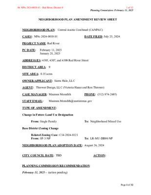
Planning Commission: February 11, 2025 NEIGHBORHOOD PLAN AMENDMENT REVIEW SHEET NEIGHORHOOD PLAN: Central Austin Combined (CANPAC) CASE#: NPA-2024-0019.01 DATE FILED: July 25, 2024 PROJECT NAME: Red River PC DATE: February 11, 2025 January 28, 2025 ADDRESS/ES: 4305, 4307, and 4309 Red River Street DISTRICT AREA: 9 SITE AREA: 0.35 acres OWNER/APPLICANT: Sierra Halo, LLC AGENT: Thrower Design, LLC (Victoria Haase and Ron Thrower) CASE MANAGER: Maureen Meredith PHONE: (512) 974-2695) STAFF EMAIL: Maureen.Meredith@austintexas.gov TYPE OF AMENDMENT: Change in Future Land Use Designation From: Single Family To: Neighborhood Mixed Use Base District Zoning Change Related Zoning Case: C14-2024-0121 From: SF-3-NP To: LR-MU-DB90-NP NEIGHBORHOOD PLAN ADOPTION DATE: August 26, 2024 CITY COUNCIL DATE: TBD ACTION: PLANNING COMMISSION RECOMMENDATION: February 11, 2025 - (action pending) Page 1 of 32 06 NPA-2024-0019.01 - Red River; District 9 1 of 32 Planning Commission: February 11, 2025 January 28, 2025 - Postponed to February 11, 2025 on the consent agenda at the request of the applicant. [R. Johnson 1st: F. Maxwell – 2nd] Vote: 11-0 [G. Anderson and A. Woods absent. F. Maxwell abstained from Item #11]. STAFF RECOMMENDATION: Staff supports the applicant’s request for Neighborhood Mixed Use land use. BASIS FOR STAFF’S RECOMMENDATION: Staff supports the applicant’s request for Neighborhood Mixed Use land use because the property is located on Red River Street which has a mix of land uses. The property is near public transportation and could provide additional housing units for the City. Below are section of the Central Austin Combined Neighborhood Plan. The Central Austin Combined Neighborhood Plan supports the preservation of single family homes in the planning area and within the Hancock area, but due to the City’s housing needs, this proposed development could provide addtinal housing units along a commercial corridor in proximity to public transporation and within walking distance from commerical uses. Page 2 of 32 06 NPA-2024-0019.01 - Red River; District 9 2 of 32 Planning Commission: February 11, 2025 Page 3 of 32 06 NPA-2024-0019.01 - Red River; District 9 3 of 32 Planning Commission: February 11, 2025 LAND USE DESCRIPTIONS: EXISTING LAND USE: Single family - Single family detached or up to three residential uses at typical urban and/or suburban densities. Purpose 1. Preserve the land use pattern and future viability of existing neighborhoods; 2. Encourage new infill development that continues existing neighborhood patterns of development; and 3. Protect residential neighborhoods from incompatible business or industry …
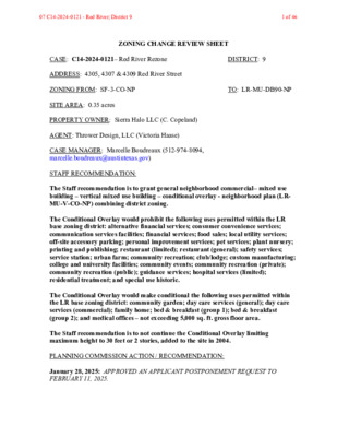
ZONING CHANGE REVIEW SHEET CASE: C14-2024-0121– Red River Rezone DISTRICT: 9 ADDRESS: 4305, 4307 & 4309 Red River Street ZONING FROM: SF-3-CO-NP TO: LR-MU-DB90-NP SITE AREA: 0.35 acres PROPERTY OWNER: Sierra Halo LLC (C. Copeland) AGENT: Thrower Design, LLC (Victoria Haase) CASE MANAGER: Marcelle Boudreaux (512-974-8094, marcelle.boudreaux@austintexas.gov) STAFF RECOMMENDATION: The Staff recommendation is to grant general neighborhood commercial– mixed use building – vertical mixed use building – conditional overlay - neighborhood plan (LR- MU-V-CO-NP) combining district zoning. The Conditional Overlay would prohibit the following uses permitted within the LR base zoning district: alternative financial services; consumer convenience services; communication services facilities; financial services; food sales; local utility services; off-site accessory parking; personal improvement services; pet services; plant nursery; printing and publishing; restaurant (limited); restaurant (general); safety services; service station; urban farm; community recreation; club/lodge; custom manufacturing; college and university facilities; community events; community recreation (private); community recreation (public); guidance services; hospital services (limited); residential treatment; and special use historic. The Conditional Overlay would make conditional the following uses permitted within the LR base zoning district: community garden; day care services (general); day care services (commercial); family home; bed & breakfast (group 1); bed & breakfast (group 2); and medical offices – not exceeding 5,000 sq. ft. gross floor area. The Staff recommendation is to not continue the Conditional Overlay limiting maximum height to 30 feet or 2 stories, added to the site in 2004. PLANNING COMMISSION ACTION / RECOMMENDATION: January 28, 2025: APPROVED AN APPLICANT POSTPONEMENT REQUEST TO FEBRUARY 11, 2025. 07 C14-2024-0121 - Red River; District 9 1 of 46 C14-2024-0121 Page 2 [R. JOHNSON; F. MAXWELL – 2ND] (10-0); G. ANDERSON, A. WOODS, A. HAYNES – ABSENT February 11, 2025: CITY COUNCIL: ORDINANCE NUMBER: ISSUES: Staff recommends LR-MU-V-CO-NP. However, staff does not recommend the DB90 combining district. The applicant’s requested zoning of LR-MU-DB90-NP does not promote compatibility with adjacent and nearby uses. This area of Red River is low-slung, primarily single family or townhome-type density with some limited sites zoned for and being used as neighborhood commercial uses. It is not an area of sites developed for dense and intense multifamily uses also situated in tall (greater than 40 feet) buildings. And, although Red River Street is categorized as ASMP level 3 at the site, it changes to an ASMP level 1 just two blocks north. Staff does support rezoning this site as mixed use and supports an …
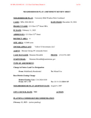
NEIGHBORHOOD PLAN AMENDMENT REVIEW SHEET NEIGHORHOOD PLAN: University Hills/Windsor Park Combined CASE#: NPA-2024-002.01 DATE FILED: December 10, 2024 PROJECT NAME: 1211 East 52nd Street NPA PC DATE: February 11, 2025 ADDRESS/ES: 1211 East 52nd Street DISTRICT AREA: 4 SITE AREA: 0.2649 acres OWNER/APPLICANT: Yellow 52 Investment, LLC AGENT: Drenner Group, PC (Amanda Swor) CASE MANAGER: Maureen Meredith PHONE: (512) 974-2695 STAFF EMAIL: Maureen.Meredith@austintexas.gov TYPE OF AMENDMENT: Change in Future Land Use Designation From: Multifamily Residential To: Mixed Use Base District Zoning Change Related Zoning Case: C14-2024-0180 From: MF-2-NP To: CS-V-CO-DB90-NP NEIGHBORHOOD PLAN ADOPTION DATE: August 9, 2007 CITY COUNCIL DATE: TBD ACTION: PLANNING COMMISSION RECOMMENDATION: February 11, 2025 - (action pending) 08 NPA-2024-0023.01 - 1211 East 52nd Street; District 4 1 of 24 STAFF RECOMMENDATION: To grant the applicant’s request for Mixed Use land use. BASIS FOR STAFF’S RECOMMENDATION: The property is proposed to be part of a larger mixed-use development that was previously approved by City Council on August 29, 2024. The applicant’s request to change the land use on the property from Multifamily Residential to Mixed Use is supported by staff because the property is within the Highland Mall Station Regional Center and is near two activity corridors, Cameron Road and E. 51st Street. The larger mixed-use development to include 1211 E. 52nd Street, is proposed to include approximately 40,000 sq. ft. of retail space, a 40,000 sq. ft. grocery store, 150,000 sq. ft. of office space, and 550 multifamily residential units. The development will provide additional housing to the area and city along with more neighborhood-serving commercial uses. LAND USE DESCRIPTIONS: EXISTING LAND USE: Multifamily Residential - Higher‐density housing with four or more dwelling units on one lot. Purpose 1. Preserve existing multifamily and affordable housing; 2. Maintain and create affordable, safe, and well-managed rental housing; and 3. Make it possible for existing residents, both homeowners and renters, to continue to live in 08 NPA-2024-0023.01 - 1211 East 52nd Street; District 4 2 of 24 their neighborhoods. 4. Applied to existing or proposed mobile home parks. Application 1. Existing apartments should be designated as multifamily unless designated as mixed use; 2. Existing multifamily-zoned land should not be recommended for a less intense land use category, unless based on sound planning principles; and 3. Changing other land uses to multifamily should be encouraged on a case-by-case basis. PROPOSED LAND USE: Mixed Use - An area that is appropriate …
ZONING CHANGE REVIEW SHEET CASE: C14-2024-0180 (1211 East 52nd Street Zoning) DISTRICT: 4 ADDRESS: 1211 East 52nd Street ZONING FROM: MF-2-NP TO: CS-V-CO-DB90-NP SITE AREA: .2649 (11,539.04 sq. ft.) PROPERTY OWNER: Yellow 52 Investments, LLC, Jonathan Saad AGENT: Drenner Group PC, Amanda Swor CASE MANAGER: Beverly Villela (512-978-0740, Beverly.Villela@austintexas.gov) STAFF RECOMMENDATION: Staff recommends granting general commercial services – vertical mixed use building – conditional overlay – density bonus 90 – neighborhood plan (CS-V-CO-DB90-NP) combining district zoning. The conditional overlay would prohibit the following uses: drive through facilities, automotive rentals, automotive repair services, automotive sales (exceeding 3,500 square feet), automotive washing of any type, bail bonds, drop-off recycling, pawn shops, pedicab storage and dispatch, funeral services, extermination services, convenience storage, equipment repair services, equipment sales, vehicle storage, and commercial blood plasma center. See the Basis of Recommendation section below. PLANNING COMMISSION RECOMMENDATION: February 11, 2025: CITY COUNCIL ACTION: TBD ORDINANCE NUMBER: ISSUES: N/A CASE MANAGER COMMENTS: The property in question spans approximately .2649 (11,539.04 sq. ft.) and is currently developed with a vacant residential four-plex. It is situated on East 52nd Street (a street level 1) and is proposed to be incorporated with the larger 8.45-acre tract that was rezoned to CS- V-CO-DB90-NP under case C14-2024-0055. The surrounding areas includes apartments 09 C14-2024-0180 - 1211 East 52nd Street Zoning; District 41 of 19 C14-2024-0180 Page 2 (MF-2-CO-NP) to the north, vacant and general retail convenience at Mueller (CS-V-CO- DB90-NP and PUD) to the south, apartments, and single family residential (CS-V-CO- DB90-NP, GR-MU-V-CO-NP, and NO-MU-NP) to the east, and general retail, administrative and business office, and single family residential (CS-V-CO-DB90-NP and MF-2-NP) to the west. Please refer to Exhibits A (Zoning Map) and B (Aerial View). The applicant is requesting general commercial services – vertical mixed use - conditional overlay – density bonus 90- neighborhood plan (CS-V-CO-DB90-NP) combining district zoning to be incorporated with the mentioned case above. The overall proposed project associated with both the current request and C14-2024-0055 will contain approximately 40,000 square feet of retail space, a 40,000 square foot grocer,150,000 square feet of office space, and 550 multifamily units. The applicant is proposing to develop under the new DB90 standards creating a project that will incorporate on-site affordable housing with 12% of the units reserved for families earning up to 60% of the Annual Median Family Income (“MFI”) or 10% of the units reserved for families earning up …
City of Austin Planning Department 6310 Wilhelmina Delco Drive, Austin, TX 78752 P.O. Box 1088, Austin, TX 78767 -1088 (512) 974-2000 ♦ h ttp s:/ / w w w.a u st in tex a s .g ov / d epa r tm e n t/ plan n in g - de part men t MEMORANDUM TO: FROM: Claire Hempel, Chair & Planning Commission Members DATE: February 5, 2025 Maureen Meredith, Senior Planner, Long-Range Planning Division Planning Department RE: NPA-2018-0021.02_5100, 5010, 5208, 5400 E. Oltorf Street & 2424 & 2424 ½ Riverside Farms Rd The applicant requests an indefinite postponement of the above-referenced case. See Ferris Clement’s email. This postponement request was made in a timely manner and meets the Planning Commission’s policy. Attachments: Ferris Clements’ Email Plan Amendment Map 10 NPA-2018-0021.02 - Skyline Oltorf Mixed Use; District 31 of 3 From: Ferris Clements Sent: Tuesday, February 4, 2025 10:02 AM To: Meredith, Maureen <Maureen.Meredith@austintexas.gov> Subject: RE: Another Indef PP? Feb 11 PC: NPA-2018- 0021.02_Skyline/Oltorf The Applicant is requesting an indefinite postponement to allow additional time to work on its plans of the Project. Maureen, Thanks, Ferris G. Ferris Clements III Attorney Armbrust & Brown, PLLC Phone: 512-435-2337 100 Congress Avenue, Suite 1300 Austin, TX 78701 www.abaustin.com 10 NPA-2018-0021.02 - Skyline Oltorf Mixed Use; District 32 of 3 10 NPA-2018-0021.02 - Skyline Oltorf Mixed Use; District 33 of 3
************************************************************************ MEMORANDUM TO: Clair Hempel, Chair Planning Commission Members FROM: Cynthia Hadri Planning Department DATE: February 4, 2025 RE: C14-2024-0124 - 1109 S. Lamar Blvd Joint Postponement Request by Staff and Applicant ************************************************************************ The case above has been scheduled for the February 11, 2025, Planning Commission hearing. The Staff and Applicant are requesting a postponement of the above referenced rezoning case from the February 11, 2025, Planning Commission hearing to the April 8, 2025 Planning Commission hearing, to allow time for staff to review the amended request. 11 C14-2024-0124 - 1109 S. Lamar Blvd; District 91 of 2 Leah M. Bojo lbojo@drennergroup.com 512-807-2918 Ms. Lauren Middleton-Pratt Planning Department City of Austin 6310 Wilhelmina Delco Drive Austin, TX 78752 Dear Lauren Middleton-Pratt, January 29, 2025 Via Electronic Delivery Re: 1109 S Lamar Boulevard – Letter rescinding first amendment to the zoning application, case no. C14-2024-0124, for the 0.287-acre property located at 1109 S Lamar Boulevard, Austin, Travis County, Texas 78704 (the “Property”). As representatives of the owner of the Property, we respectfully submit this letter to rescind the prior amendment to this application currently under review, zoning case no. C14-2024-0124 for the project titled 1109 S Lamar Boulevard, initially submitted on August 1, 2024 and amended on September 30, 2024. The September 30th amendment requested to the rezone the Property was from CS-1-V-CO (Commercial- Liquor Sales – Vertical Mixed Use Building – Conditional Overlay) to LI-PDA (Limited Industrial Services – Planned Development Area). At this time we would like to revert back to the original request of CS-1-V-CO to CS-1-MU-V-CO-DB90 (Commercial-Liquor Sales – Mixed Use – Vertical Mixed Use Building – Conditional Overlay – Density Bonus 90). Please let me know if you or your team members require additional information or have any questions. Thank you for your time and attention to this matter. Best Regards, Leah M. Bojo Joi Harden, Planning Department (via electronic delivery) Cynthia Hadri, Planning Department (via electronic delivery) 2705 Bee Cave Road, Suite 100 | Austin, Texas 78746 | 512-807-2900 | www.drennergroup.com cc: 11 C14-2024-0124 - 1109 S. Lamar Blvd; District 92 of 2
ZONING CHANGE REVIEW SHEET CASE: C14-2024-0137 - 1207 S. 1st Street DISTRICT: 9 ADDRESS: 1207 and 1209 South 1st Street SITE AREA: 0.492 acres (21,431 sq. ft.) ZONING FROM/TO: CS-MU-V-CO-ETOD-DBETOD-NP, to change conditions of zoning, including the conditional overlay and a modification for the pedestrian-oriented commercial spaces requirement. PROPERTY OWNER: 1207 – 1209 S 1st Partners LLC AGENT: Drenner Group, PC (Leah Bojo) CASE MANAGER: Cynthia Hadri 512-974-7620, Cynthia.hadri@austintexas.gov STAFF RECOMMENDATION: The staff recommendation is to grant a change of conditions to general commercial services – mixed use – vertical mixed use building – conditional overlay – equitable transit-oriented development – density bonus equitable-transit oriented development - neighborhood plan (CS-MU-V-CO-ETOD-DBETOD-NP) combining district zoning. The conditional overlay will be modified to remove a portion of a building or structure that exceeds 35 feet in height must fit within an envelope delineated by a 60-degree angle measured from the top of the structure to a property line that adjoins a public street. Staff recommends granting the applicant’s modification request to not provide pedestrian-oriented commercial space (to provide 0% of the requirement). PLANNING COMMISSION ACTION / RECOMMENDATION: February 11, 2025: CITY COUNCIL ACTION: ORDINANCE NUMBER: 12 C14-2024-0137 - 1207 S 1st Street; District 91 of 27 C14-2024-0137 2 ISSUES: On March 9, 2023, City Council approved Resolution No. 20230309-016 accepting the Equitable Transit-Oriented Development Policy Plan and directing the City Manager regarding next steps for implementation of items intended to benefit the Project Connect Phase 1 Austin Light Rail project. This included development of code amendments to support transit in May of 2024 (Ordinance No. 20240516-005), including creation of the ETOD combining district (restrictions on non-transit supportive uses) and the DBETOD combining district (allowing residential use, and relaxing some development standards including increased height in exchange for income-restricted housing). Properties within one half-mile of the Phase 1 Austin Light Rail alignment and Priority Extensions were included within this overlay, and certain properties were rezoned through a City-initiated process to include the ETOD and DBETOD combining districts. Further, properties rezoned with DBETOD combining district were categorized into Subdistrict 1 (maximum allowable height of 120 feet) or Subdistrict 2 (maximum allowable height of 90 feet), generally based on property distance of ¼-mile or ½-mile from the Phase 1 alignment, respectively. The subject of this request is to allow change in conditions of zoning: modification to the pedestrian-oriented commercial/civic requirements and modification of Conditional Overlay (CO). …
ZONING CHANGE REVIEW SHEET CASE: C14-2024-0182 DISTRICT: 2 ADDRESS: 5706 AND 5708 NANCY DR ZONING FROM: MH-NP TO: SF-3-NP SITE AREA: 0.48 acres PROPERTY OWNER: Capital River Group, LLC - Series 29 AGENT: Capital River Group, LLC - Series 29 (Stuart Carr) CASE MANAGER: Tiffany Magnavice (512-978-0722, tiffany.magnavice@austintexas.gov) STAFF RECOMMENDATION: The Staff recommendation is to grant family residence – neighborhood plan (SF-3-NP) combined district zoning. PLANNING COMMISSION ACTION / RECOMMENDATION: February 11, 2025: ORDINANCE NUMBER: ISSUES: No issues at this time. CASE MANAGER COMMENTS: The subject rezoning area is two developed lots totaling approximately 0.48 acres, containing one mobile home spanning across both lots and one detached garage. It is situated mid-block on Nancy Drive (Level 1/Local) between Sahara Avenue (Level 1/Local) and West Stassney Lane (Level 3/Corridor). Development on Nancy Drive is generally characterized by mobile home residences and moderate density residences (MH-NP; SF-2-NP; SF-3-NP). There are also limited density multifamily residences, unified shopping centers, and individually developed commercial sites on the corner of West Stassney Lane (MF-1-CO-NP; GR-NP). Please refer to Exhibits A (Zoning Map), A-1 (Aerial View). The applicant is proposing to rezone the property to family residence – neighborhood plan (SF-3-NP) combined district zoning for a residential development that will include three (3) dwelling units on each lot, for a total of six (6) dwelling units. Demolition is proposed. Please refer to Exhibit B (Applicant’s Summary Letter ). 13 C14-2024-0182 - 5706 Nancy Dr; District 21 of 10 C14-2024-0182 Page 2 Staff is recommending family residence-neighborhood plan (SF-3-NP) combined district zoning. This property meets the intent of the district and would increase overall housing in this area of the City, as well as support the addition of missing-middle housing units. Currently, three residential units are not permitted with the existing zoning, mobile home residence-neighborhood plan (MH-NP). The new HOME amendments will allow up to three housing units on a Single-Family (SF1, SF-2 and SF-3) zoned property. BASIS OF RECOMMENDATION: 1. The proposed zoning should be consistent with the purpose statement of the district sought. Zoning changes should promote an orderly relationship among land uses. The family residence (SF-3) district is the designation for a moderate density single-family residential use and a duplex use on a lot that is a minimum of 5,750 square feet. An SF-3 district designation may be applied to a use in an existing single-family neighborhood with moderate sized lots or to new …
ZONING CHANGE REVIEW SHEET CASE: C14-2024-0166 – W Ben White Multifamily DISTRICT: 3 ADDRESS: 603, 611, 613, 623, 625, and 629 West Ben White Boulevard Service Road Eastbound ZONING FROM: GR-V-NP; CS-V-NP; CS-1-V-NP TO: CH-PDA-NP SITE AREA: 3.966 acres PROPERTY OWNER: 603 W Ben White Owner, LLC, a Delaware limited liability company (Michael J. Murphy) AGENT: DuBois Bryant & Campbell, LLP (David Hartman) CASE MANAGER: Nancy Estrada (512-974-7617, nancy.estrada@austintexas.gov) STAFF RECOMMENDATION: The Staff recommendation is to grant commercial highway services – planned development area – neighborhood plan (CH-PDA-NP) combining district zoning. The basis of Staff’s recommendation is provided on pages 1 - 4. PLANNING COMMISSION ACTION / RECOMMENDATION: February 11, 2024: CITY COUNCIL ACTION: ORDINANCE NUMBER: ISSUES: None at this time. CASE MANAGER COMMENTS: The subject rezoning area consists of approximately 3.966 acres located at the southwest corner of West Ben White Boulevard Eastbound Service Road and South 1st Street. Currently, the site is developed with various commercial uses, including a supermarket, restaurant, beauty college/salon, and a cocktail lounge, along with surface parking. Additionally, a vacant medical equipment sales building is located on the property. The overall site is zoned community commercial – vertical mixed use building – neighborhood 14 C14-2024-0166 - W Ben White Multifamily; District 31 of 13 C14-2024-0166 Page 2 plan (GR-V-NP) with the supermarket area zoned as general commercial services – vertical mixed use building – neighborhood plan (CS-V-NP). An 8,862 square-foot cocktail lounge on the property is zoned commercial-liquor sales – vertical mixed use building – neighborhood plan (CS-1-V-NP). The subject area borders the Hospital Special District along its western and southern boundaries. The Hospital Special District encompasses medical offices/clinics, a medical park and St. David’s South Austin Medical Center (CH-PDA-NP; LO-V-NP; PUD-NP). There is a fire station and an auto service directly to the south (GO-CO-NP; GR-V-NP) and commercial services to the east across South 1st Street (GR-V-NP; GR-NP; CS-MU-NP). Please refer to Exhibits A (Zoning Map) and A-1 (Aerial View). The site has frontage along West Ben White Boulevard Eastbound Service Road, a major arterial roadway, and South 1st Street, a Level 3 roadway and a designated Imagine Austin Corridor. The property will have access from both roadways. Public transit is available with a Capital Metro bus route and bus stop along South 1st Street. Additionally, there are several bus stops located at The Capital Metro South Congress Transit Center which is located …
ZONING CHANGE REVIEW SHEET CASE: C14-2024-0161 (505 Oakland Ave Rezoning) DISTRICT: 9 ADDRESS: 505 and 507 Oakland Avenue ZONING FROM: LO-NP TO: CS-MU-CO-NP SITE AREA: approximately 0.35 acres (approximately square feet) PROPERTY OWNER: 505 Oakland Ave, LLC AGENT: HD Brown Consulting, LLC (Amanda Brown) CASE MANAGER: Jonathan Tomko (512) 974-1057, jonathan.tomko@austintexas.gov STAFF RECOMMEDATION: Staff recommends granting general commercial services-mixed use-conditional overlay- neighborhood plan (CS-MU-CO-NP) combining district zoning. The conditional overlay would prohibit the following 28 uses: Adult-Oriented Business; Agricultural Sales and Services; Automotive Repair Services; Bail Bond Services; Campground; Construction Sales and Services; Custom Manufacturing; Electronic Prototype Assembly; Indoor Crop Production; Automotive Washing – of any type; Building Maintenance Services; Commercial Off-street Parking; Convenience Storage; Drop- off Recycling Collection Facilities; Exterminating Services; Kennels; Limited Warehousing and Distribution; Pawn Shop Services; Service Station; Monument Retail Services; Research Services; Vehicle Storage; Equipment Repair Services; Maintenance and Services Facilities; Automotive Rentals; Automotive Sales; Commercial Blood Plasma Center; Outdoor Entertainment; Outdoor Sports and Recreation. The conditional overlay would conditionally allow the following four uses: Equipment Sales; Laundry Services; Residential Treatment; Guidance Services For a summary of the basis of Staff’s recommendation, please see the basis of recommendation section below. PLANNING COMMISSION RECOMMENDATION: February 11, 2025: Case is scheduled to be heard by Planning Commission. CITY COUNCIL ACTION: March 27, 2025: Case is tenatively scheduled to be heard by City Council. ORDINANCE NUMBER: N/A 15 C14-2024-0161 - 505 Oakland Ave Rezoning; District 91 of 9 C14-2024-0161 ISSUES: N/A 2 CASE MANAGER COMMENTS: The site is relatively flat and not in a flood plain. The property is located between W 6th Street and W 5th Street, on a block approximately one-half mile west of Lamar Boulevard and one-half mile east of Mopac. In this location, Oakland Avenue is a one-way street with southbound only traffic. Like the subject property itself, the immediate area is dominated by offices housed in former single-family homes. To the north and south there are small-scale, older office/retail buildings. To the east, across Pressler there is a five-story apartment building (The Pressler) with approximately 168 units. To the west are two small-scale, older office/retail buildings. BASIS OF RECOMMENDATION: Zoning should promote clearly identified community goals, such as creating employment opportunities or providing for affordable housing. The property falls within the bounds of the Old West Austin Neighborhood Plan (OWANP), approved in 2002. • OWANP identifies "neighborhood-friendly" commercial areas where office, retail, and …
15 2024-128390 LM - 1114 W 5th Street; District 91 of 14 15 2024-128390 LM - 1114 W 5th Street; District 92 of 14 15 2024-128390 LM - 1114 W 5th Street; District 93 of 14 15 2024-128390 LM - 1114 W 5th Street; District 94 of 14 15 2024-128390 LM - 1114 W 5th Street; District 95 of 14 15 2024-128390 LM - 1114 W 5th Street; District 96 of 14 15 2024-128390 LM - 1114 W 5th Street; District 97 of 14 15 2024-128390 LM - 1114 W 5th Street; District 98 of 14 15 2024-128390 LM - 1114 W 5th Street; District 99 of 14 15 2024-128390 LM - 1114 W 5th Street; District 910 of 14 15 2024-128390 LM - 1114 W 5th Street; District 911 of 14 15 2024-128390 LM - 1114 W 5th Street; District 912 of 14 15 2024-128390 LM - 1114 W 5th Street; District 913 of 14 15 2024-128390 LM - 1114 W 5th Street; District 914 of 14
TO: Planning Commission M E M O R A N D U M FROM: Christopher Bueckert, Real Estate Services Agent, Land Development Engineering, Transportation and Public Works Department DATE: February 11, 2025 (Originally scheduled 12/17/2024, and first postponement 1/28/2025) SUBJECT: F# 2024-128390 LM (1114 West 5th Street) Street & Alley Right-of-Way Vacation approximately 4,516 square foot portion of land abutting 1114 West 5th Street & 1134 Sayers Street Attached is the Application Packet and Master Comment Report pertaining to the street and alley right-of-way vacation application for an approximately 4,516 square foot portion of land, being the paved/developed right-of-way abutting 1114 West 5th Street & 1134 Sayers Street, as shown on a map of survey made for G. Flury of Lot #1 & part of Lots #2 - 3 & 4 Block #10, Out Lot #11 Division Z, City of Austin, a Map of Survey recorded in Volume 3, Page 171 of the Plat Records of Travis County; being a portion of Sayers Street, a 40’ Right-of-way, the south 20’ being dedicated and shown as a 20’ Alley in Block 10, Sayers Subdivision, a subdivision recorded in Volume 1, Page 29 of the Plat Records of Travis County. The proposed vacation tract will be added to the abutting parcels. The abutting properties are owned by Anchor Equities Ltd, a Texas limited partnership. Per the transmittal letter dated September 21, 2024, received by the City of Austin, the applicant states, “How do you plan to develop the area to be vacated? Response: It is unknown at this time how the right of way vacation area would be developed.” All affected departments and private utility franchise stakeholders have reviewed the application and recommend approval, subject to the reviewers’ conditions shown on the attached Master Comment Report. Per City Code §14-11-71 – Notice to Interested Property Owners Public notice will be sent to owners within 300’ of the area to be vacated. The director of the Public Works Department may approve the application after the 10 th day that the notice is issued; and an affected property owner may submit comments regarding the proposed vacation. Public Notice was sent to appropriate parties on December 5, 2024. Staff has received a public objection as of the date of this memorandum. Please see the attached document. The applicant has requested that this item be submitted for placement on the proposed February 4, 2025, Urban Transportation …
Bueckert, Christopher From: Sent: To: Cc: Subject: Tyler Grooms Sunday, December 15, 2024 3:37 PM Bueckert, Christopher Stefanie and Stephen Griffith; Mila Santana Sayers Street Vacation - (2024-128390 LM) at 1114 West 5th Street Amanda Hendrix; You don't often get email from Learn why this is important External Email - Exercise Caution Christopher, I’m writing to request that the vacation of Sayer’s Street be removed from the agenda for Planning Commission on Tuesday. We were surprised to learn about this process only through the notification process to go to planning commission. Our understanding is that according to §311.008 Transportation Code, the city may vacate, abandon, or close a street by ordinance if a petition signed by all owners of real property abutting the street is submitted to the governing body. We are unaware of this petition and the owners have never signed such a petition. Per the included backup for Planning Commission, the owner’s property clearly abuts and takes access to Sayers Street (both Lot 19 and 18 abut Sayers Street). The owners of the property are copied on this email as well (Stefanie and Stephen Griffith of Griffith Properties) who object to the vacation of Sayers Street. Currently their tenants at 503 and 505 Walsh Street (tenants of their family’s partnership Walsh Street Venture 2, LLC) make regular use of Sayers Street. Marc Fray (the tenant at 503 and 505 Walsh Street) depends (and has depended for a decade) on Sayers Street to have furniture delivered to his business. Sayers Street is the only access point to this property for large trucks as access via Walsh Street is too steep and narrow for trucks. It is important to note that Sayers Street is so crucial to Mr. Fray's business that the Griffiths are in breach of contract if Sayers is vacated and Mr. Fray loses access to his business (see section 4 in below attachment). Therefore, as directly adjoining property owners having small local business tenants whose existence has depended for decades on Sayers Street, the Griffith’s object fully and strongly to vacating Sayers Street. Finally, we are working on developing the Griffith’s property. Our plans submitted to the city (SP-2024-0428) demonstrate the continued and necessary use of Sayers Street for fire access, utility access, vehicular access and loading access as a vital part of the development plan. 1 15 2024-128390 LM - 1114 W 5th Street; District 9 …
15 2024-128390 LM - 1114 W 5th Street; District 91 of 31 15 2024-128390 LM - 1114 W 5th Street; District 92 of 31 15 2024-128390 LM - 1114 W 5th Street; District 93 of 31 Right of Way Vacation Transmittal Letter LandManagementROW@AustinTexas.gov | Phone: 311 (or 512-974-2000 outside Austin) Forsubmittal and feeinformation, see www.austintexas.gov/department/land-management Provideareasonforthevaca�onbyansweringthefollowingques�ons:1.PropertyType:Residen�alCommercial2.Howwasheareaobevacaeddedicaed?PlaSeparaeInstrument3.DidheCiypurchaseheareaobevacaed?(i.e.,bySreeDeed)YesNo4.Arebohheareaobevacaedandyourproperyinhesame“subdivision”?(Theymusbohbeinhesamesubdivisionobeeligible.)YesNo5.Isheareaobevacaeda:Func�onalrigh-of-wayOnlydedicaedonpaper6.Arehereanyu�liylineswihinheareaobevacaed?YesNoIfyes,whaareyourplansforheu�li�es?___________________________________________________________________________________________________________________________________Applicansshouldbeadvisedhaeasemenswillbereainedoproecexis�ngu�li�es,evenifu�liyreloca�onisproposed.Alsobeadvisedhanosrucuresmaybebuilon,overorunderheeasemenswihoualicenseagreemen,insurance,andannualfee.7.Howdoyouplanodevelopheareaobevacaed?_______________________________________________________________________________________________________________________8.Hasasieplanbeensubmittedonyourprojec?YesNo9.IsyourprojecaUnifiedDevelopmen?YesNo10.IsyourprojecaS.M.A.R.T.HousingProjec?YesNo11.Whendoyouan�cipaesar�ngconsruc�onofhedevelopmen?________________________12.Whaishecurrenzoningonheadjacenproper�es?_________________________________13.Whaishecurrensausofheadjacenproper�es?__________________________________14.Whaypeofparkingfacili�escurrenlyexis?________________________________________15.Willyourparkingrequiremensincreasewihheexpansion?YesNo16.Howwillheincreasebehandled?__________________________________________________________________________________________________________________________________Utilities will stay in place. Property owner acknoweasments will be retained as partof Deed without WarrantyIt is unknown at this time how theright of way vacation area would be developedUnknownCS MU CO NP and CS MU V CO Small retail storesPaved parking lotN/A15 2024-128390 LM - 1114 W 5th Street; District 94 of 31 Right of Way Vacation Transmittal Letter LandManagementROW@AustinTexas.gov | Phone: 311 (or 512-974-2000 outside Austin) Forsubmittal and feeinformation, see www.austintexas.gov/department/land-management 17.Haveanyagreemensoreasemensbeenexecuedwihadjacenlandowner(s)orindraform?YesNoIfyes,pleaseprovideuswihacopy.18.DoesheareaobevacaedliewihinheAus�nDownownPlan(DAP)?YesNoIfyes,doesimeeDAPcrieria?YesNo19.DoesheareaobevacaedliewihinUTboundaries:EasofLamarBoulevard,wesofIH35,norhofMar�nLuherKingBoulevard,andsouhof45hSree?YesNo20.Doesheproposedvaca�onsupporhePrioriyProgramsandpolicydirec�vesseforhinheImagineAus�nComprehensivePlan?YesNoIfyes,how__________________________________________________________________________________________________________________________________________________________If you have questions; please email Land Management Department: LandManagementROW@AustinTexas.gov Continue to grow Austin's economy by investing in our workforce,education systems, entrepreneurs, and local businesses15 2024-128390 LM - 1114 W 5th Street; District 95 of 31 Right of Way Vacation Transmittal Letter LandManagementROW@AustinTexas.gov | Phone: 311 (or 512-974-2000 outside Austin) Forsubmittal and feeinformation, see www.austintexas.gov/department/land-management Provideareasonforthevaca�onbyansweringthefollowingques�ons:1.PropertyType:Residen�alCommercial2.Howwasheareaobevacaeddedicaed?PlaSeparaeInstrument3.DidheCiypurchaseheareaobevacaed?(i.e.,bySreeDeed)YesNo4.Arebohheareaobevacaedandyourproperyinhesame“subdivision”?(Theymusbohbeinhesamesubdivisionobeeligible.)YesNo5.Isheareaobevacaeda:Func�onalrigh-of-wayOnlydedicaedonpaper6.Arehereanyu�liylineswihinheareaobevacaed?YesNoIfyes,whaareyourplansforheu�li�es?___________________________________________________________________________________________________________________________________Applicansshouldbeadvisedhaeasemenswillbereainedoproecexis�ngu�li�es,evenifu�liyreloca�onisproposed.Alsobeadvisedhanosrucuresmaybebuilon,overorunderheeasemenswihoualicenseagreemen,insurance,andannualfee.7.Howdoyouplanodevelopheareaobevacaed?_______________________________________________________________________________________________________________________8.Hasasieplanbeensubmittedonyourprojec?YesNo9.IsyourprojecaUnifiedDevelopmen?YesNo10.IsyourprojecaS.M.A.R.T.HousingProjec?YesNo11.Whendoyouan�cipaesar�ngconsruc�onofhedevelopmen?________________________12.Whaishecurrenzoningonheadjacenproper�es?_________________________________13.Whaishecurrensausofheadjacenproper�es?__________________________________14.Whaypeofparkingfacili�escurrenlyexis?________________________________________15.Willyourparkingrequiremensincreasewihheexpansion?YesNo16.Howwillheincreasebehandled?__________________________________________________________________________________________________________________________________Utilities will stay in place. Property owner acknoweasments will be retained as partof Deed without WarrantyIt is unknown at this time how theright of way vacation area would be developedUnknownCS MU CO NP and CS MU V CO Small retail storesPaved parking lotN/A15 2024-128390 LM - 1114 W 5th Street; District 96 of 31 Right of Way Vacation Transmittal Letter LandManagementROW@AustinTexas.gov | Phone: 311 (or 512-974-2000 outside Austin) Forsubmittal and feeinformation, see www.austintexas.gov/department/land-management 17.Haveanyagreemensoreasemensbeenexecuedwihadjacenlandowner(s)orindraform?YesNoIfyes,pleaseprovideuswihacopy.18.DoesheareaobevacaedliewihinheAus�nDownownPlan(DAP)?YesNoIfyes,doesimeeDAPcrieria?YesNo19.DoesheareaobevacaedliewihinUTboundaries:EasofLamarBoulevard,wesofIH35,norhofMar�nLuherKingBoulevard,andsouhof45hSree?YesNo20.Doesheproposedvaca�onsupporhePrioriyProgramsandpolicydirec�vesseforhinheImagineAus�nComprehensivePlan?YesNoIfyes,how__________________________________________________________________________________________________________________________________________________________If you have questions; please email Land Management Department: LandManagementROW@AustinTexas.gov Continue to grow Austin's economy by investing in our workforce,education systems, entrepreneurs, and local businesses15 2024-128390 LM - 1114 W 5th Street; District 97 of 31 PropertyProfileROWvacationrequestSayersSt.LegendPropertyAddressesJurisdictionFULLPURPOSEJurisdictionsFillJurisdictionFULLPURPOSENotesBetween1134SayersSt.and1114W.5th0150300ftThisproductisforinformationalpurposesandmaynothavebeenpreparedfororbesuitableforlegal,engineering,orsurveyingpurposes.Itdoesnotrepresentanon-the-groundsurvey.ThisproducthasbeenproducedbytheCityofAustinforthesolepurposeofgeographicreference.NowarrantyismadebytheCityofAustinregardingspecificaccuracyorcompleteness.9/21/202415 2024-128390 LM - 1114 W 5th Street; District 98 of 31 P:\01924\Metes&Bounds&Certifications\01924_NORTH.docxPage1of19/26/24TBPLSFirm#10174300POBox90876Austin,TX78709512.537.2384www.4wardls.comEXHIBIT“______”(Right-Of-WayVacation)LegalDescriptionBEINGADESCRIPTIONOFATRACTOFLANDCONTAINING0.0517ACRE(2,253SQUAREFEET),BEINGAPORTIONOFSAYERSSTREET,A40’RIGHT-OF-WAYANDSHOWNASAPORTIONOFACALLED40’STREETINMAPOFSURVEYMADEFORG.FLURYOFLOT#1&PARTOFLOTS#2-3&4BLOCK#10,OUTLOT#11DIVISIONZ,CITYOFAUSTIN,AMAPOFSURVEYRECORDEDINVOLUME3,PAGE171OFTHEPLATRECORDSOFTRAVISCOUNTY,TEXAS(P.R.T.C.T.),SAID0.0517ACREBEINGMOREPARTICULARLYDESCRIBEDBYMETESANDBOUNDSASFOLLOWS:BEGINNING,ata1/2-inchironpipefoundintheeastlineofLot18,Block1,LauraP.Duval’sSubdivisionoftheeasthalfofLotNo.1,Division“Z”oftheOutlotsAdjoiningtheCityofAustin,asubdivisionofTravisCounty,TexasrecordedinVolume1,Page23(P.R.T.C.T.),forthesouthwestcornerofacalled0.303acretractdescribedas“Tract1”alsobeingthesouthwest120feetx100feetofLot4,Block10,Raymond’sPlateau,asubdivisionofTraviscounty,Texas,recordedinVolume1,Page30,(P.R.T.C.T.)conveyedtoAnchorEquities,LTD.InDocumentNo.2013206747oftheOfficialPublicrecordsofTravisCounty,Texas(O.P.R.T.C.T.),beingthenorthwestterminusofsaidSayersstreetandPOINTOFBEGINNINGhereof,fromwhicha1/2-inchironpipefoundinthewestlineofsaidAnchorEquities“Tract1”,forthenortheastcornerofsaidLot18bears,N21°50’59”E,adistanceof51.85feet;THENCE,withthenorthright-of-waylineofsaidSayersStreetandthesouthlineofsaidAnchorEquities“Tract1”,S67°45'43"E,adistanceof112.03feettoacalculatedpointforthenortheastcornerhereof,fromwhicha1/2-inchironrodfoundforthesoutheastcornerofsaidAnchorEquities“Tract1”andananglepointinthewestlineofLot1,ElmSquareAddition,asubdivisionofTravisCounty,Texas,recordedinVolume85,Page74C(P.R.T.C.T.)bears,S67°45'43"E,adistanceof7.30feet;THENCE,leavingthecommonlineofsaidSayersstreetandsaidAnchorEquities“Tract1”,overandacrosssaidSayersstreetthefollowingtwo(2)coursesanddistances:1)S22°16'54"W,adistanceof20.07feettoacalculatedpointforthesoutheastcornerhereof,2)N67°43'45"W,adistanceof112.90feettoacalculatedpointintheeastlineofLot19,ofsaidBlock1,LauraP.Duval’sSubdivisionandthewestright-of-waylineofsaidSayersstreetforthesouthwestcornerhereof,THENCE,inpartwiththeeastlinesofsaidLot18andsaidLot19,Block1,LauraP.Duval’sSubdivision,andthewestright-of-waylineofsaidSayersstreetN24°45'13"E,adistanceof20.02feettothePOINTOFBEGINNINGandcontaining0.0517Acre(2,253SquareFeet)ofland,moreorless.Notes:AllbearingsarebasedontheTexasStatePlaneCoordinateSystem,GridNorth,CentralZone(4203);alldistanceswereadjustedtosurfaceusingacombinedscalefactorof1.000060558237.Seeattachedsketch(referencedrawing:01924_NORTH.dwg.)_______________________________JasonWard,RPLS#58114WardLandSurveying,LLC12/09/2415 2024-128390 LM - 1114 W 5th Street; District 99 of 31 SAYERSSTREET(40'R.O.W.)W5THSTREET(R.O.W.VARIES)POBox90876,AustinTexas78709INFO@4WARDLS.COM(512)537-2384TBPELSFIRM#10174300ALimitedLiabilityCompany0.0517ACRER.O.W.VACATIONCityofAustinTravisCounty,Texas15 2024-128390 LM - 1114 W 5th Street; District 910 of 31 0.0517ACRER.O.W.VACATIONEASEMENTTravisCounty,TexasPOBox90876,AustinTexas78709INFO@4WARDLS.COM(512)537-2384TBPELSFIRM#10174300ALimitedLiabilityCompany15 2024-128390 LM - 1114 W 5th Street; District 911 of 31 P:\01924\Metes&Bounds&Certifications\01924_SOUTH.docxPage1of2TBPLSFirm#10174300POBox90876Austin,TX78709512.537.2384www.4wardls.comEXHIBIT“______”(Right-Of-WayVacation)LegalDescriptionBEINGADESCRIPTIONOFATRACTOFLANDCONTAINING0.0520ACRE(2,263SQUAREFEET),BEINGAPORTIONOFSAYERSSTREET,A40’RIGHT-OF-WAY,THESOUTH20’BEINGDEDICATEDANDSHOWNASA20’ALLEYINBLOCK10,SAYERSSUBDIVISION,ASUBDIVISIONRECORDEDINVOLUME1,PAGE29OFTHEPLATRECORDSOFTRAVISCOUNTY,TEXAS(P.R.T.C.T.),SAID0.0520ACREBEINGMOREPARTICULARLYDESCRIBEDBYMETESANDBOUNDSASFOLLOWS:COMMENCING,ata1/2-inchironpipefoundinthenorthright-of-waylineofW.5thstreet(right-of-wayvaries),forthesoutheastcornerofacalled0.174acretractdescribedas“Tract2”alsobeingthenorth66.7feetofLots8and9,Block1,SayersSubdivision,asubdivisionofTravisCounty,Texas,recordedinVolume1Page29(P.R.T.C.T.)andconveyedtoAnchorEquities,LTD.InDocumentNo.2013206747,oftheOfficialPublicRecordsofTravisCounty,Texas(O.P.R.T.C.T.),forthesouthwestcornerofacalled3,333.5squarefeettractoflandtobededicatedasSayersstreet,conveyedtotheCityofAustininVolume8271,Page812,oftheDeedRecordsofTravisCounty,Texas(D.R.T.C.T),fromwhicha1/2-inchironrodfoundforananglepointinthenorthlineofsaidW.5thstreet,alsobeingintheeastlineofLot20,Block1,LauraP.Duval’sSubdivisionoftheeasthalfofLotNo.1,Division“Z”oftheOutlotsAdjoiningtheCityofAustin,asubdivisionofTravisCounty,TexasrecordedinVolume1,Page23(P.R.T.C.T.)andbeingthesouthwestcornerofsaidAnchorEquities“Tract2”bears,N67°52’12”W,adistanceof113.94feet;THENCE,withthecommonlineofsaidAnchorEquities“Tract2”andsaidCityofAustintract,N22°14'01"E,adistanceof66.56feettoacalculatedpointforthecommonnorthcornerofsaidAnchorEquities“Tract2”andsaidCityofAustintract,forananglepointinthesouthright-of-waylineofsaidSayersstreet,forthePOINTOFBEGINNINGhereof,THENCE,withthecommonlineofsaidSayersstreetandsaidAnchorEquities“Tract2”,N67°41'49"W,adistanceof113.79feettoa1/2-inchironrodfoundintheeastlineofLot19,ofsaidBlock1,LauraP.Duval’ssubdivision,forthesouthwestterminusofsaidSayersstreetandforthenorthwestcornerofsaidAnchorEquities“Tract2”forthesouthwestcornerhereof,THENCE,withthecommonlineofsaidLot19,andsaidSayersstreet,N24°45'13"E,adistanceof19.95feettoacalculatedpointforthenorthwestcornerhereof,fromwhicha1/2-inchironpipefoundintheeastlineofLot18,ofsaidBlock1,LauraP.Duval’sSubdivision,forthesouthwestcornerofacalled0.303acretractdescribedas“Tract1”alsobeingthesouthwest120feetx100feetofLot4,Block10,Raymond’sPlateau,asubdivisionofTraviscounty,Texas,recordedinVolume1,Page30,(P.R.T.C.T.)conveyedtoAnchorEquities,LTD.InDocumentNo.2013206747(O.P.R.T.C.T.),beingthenorthwestterminusofsaidSayersstreetbears,N24°45'13"E,adistanceof20.02feet,THENCE,leavingtheeastlineofsaidLot19,overandacrosssaidSayersstreetthefollowingtwo(2)coursesanddistances:15 2024-128390 LM - 1114 W 5th Street; District 912 of 31 P:\01924\Metes&Bounds&Certifications\01924_SOUTH.docxPage2of29/26/241)S67°43'45"E,adistanceof112.90feettoacalculatedpointforthenortheastcornerhereof,2)S22°11'23"W,adistanceof20.00feettothePOINTOFBEGINNINGandcontaining0.0520Acre(2,263SquareFeet)ofland,moreorless.Notes:AllbearingsarebasedontheTexasStatePlaneCoordinateSystem,GridNorth,CentralZone(4203);alldistanceswereadjustedtosurfaceusingacombinedscalefactorof1.000060558237.Seeattachedsketch(referencedrawing:01924_SOUTH.dwg.)_______________________________JasonWard,RPLS#58114WardLandSurveying,LLC12/09/2415 2024-128390 LM - 1114 W 5th Street; District 913 of 31 W5THSTREET(R.O.W.VARIES)SAYERSSTREET(40'R.O.W.)POBox90876,AustinTexas78709INFO@4WARDLS.COM(512)537-2384TBPELSFIRM#10174300ALimitedLiabilityCompany0.0520ACRER.O.W.VACATIONCityofAustinTravisCounty,Texas15 2024-128390 LM - 1114 W 5th Street; District 914 of 31 POBox90876,AustinTexas78709INFO@4WARDLS.COM(512)537-2384TBPELSFIRM#10174300ALimitedLiabilityCompany0.0520ACRER.O.W.VACATIONCityofAustinTravisCounty,Texas15 2024-128390 LM - 1114 W 5th Street; District 915 of 31 15 2024-128390 LM - 1114 W 5th Street; District 916 of 31 …
Affordability Impact Statement Short Term Rental Regulations Res. No. 20221208-064, Ord. No. 20231207-001 Date: 2/5/2025 Proposed Regulation The ordinance introduces new regulations for the Austin’s short-term rental (STR) market after various court decisions invalidated several the City of Austin’s (COA) current STR regulations. Together, Zaatari v. City of Austin (2019), Hignell-Stark vs. City of New Orleans (2022), and Anding vs. City of Austin (2023) removed COA’s authority to restrict STRs by owner type, which was formerly in place to curtail the financialization of COA’s housing stock by STR investors. The ordinance moves most of the COA’s STR regulations from City Code Title 25 (Land Development) and creates new STR regulations under City Code Title 4 (Business Regulations and Permit Requirements). The proposed ordinance will: (1) make STRs an accessory-use to all residential uses in all zoning districts for licensed operators (2) limit STR operators by density on a lot (3) stipulate that the STR not become a public nuisance (4) require the platforms to collect COA’s Hotel Occupancy Tax (HOT) from operators Land Use/Zoning Impacts on Housing Costs The proposed changes would have a neutral impact on housing costs compared to current regulations. Many of the COA’s historical efforts to limit STRs have been invalidated. Inside Airbnb reports about 15,000 STRs in Austin, while COA’s database only shows record of about 2,000 licenses. Even accounting for data errors or issues in chronology, a significant number of STRs in Austin neither have licenses nor remit HOT to COA for 17 C20-2024-014 - STR Modifications1 of 6 their operations. Without updated licensing regulations, COA is limited in its ability to enforce restrictions or bans in the case of nuisance or other violations. The proposed ordinance takes steps towards rectifying the imbalance between the STR market and COA’s authority to enforce regulations on operators. The proposed ordinance seeks to address the gap between STR market activity and COA’s enforcement capabilities. Enhanced licensing and monitoring mechanisms will better equip COA to manage STR operators. While the current legal landscape limits Austin’s ability to regulate STRs, peer-reviewed research widely shows that STRs are associated with increased housing costs for renters, although some studies suggest the relationship may not always be causal. Below is a summary table of a subset of this research; please see the full list of references from the literature review at the end of the document. Author Cho, A. Sponsoring Institution(s) Princeton …
1 2 3 4 5 6 7 8 9 10 11 12 13 14 15 16 17 18 19 20 21 22 23 24 25 26 27 28 29 WORKING DRAFT AND SUBJECT TO CHANGE – 1/10/2025 ORDINANCE NO. AN ORDINANCE AMENDING CITY CODE CHAPTER 25-2 RELATED TO SHORT-TERM RENTAL USE AND REGULATIONS. BE IT ORDAINED BY THE CITY COUNCIL OF THE CITY OF AUSTIN: PART X. City Code Chapter 25-2, Subchapter C, Article 4, Division 1, Subpart C (Requirements for Short-Term Rental Uses) and City Code Section 25-2-950 (Discontinuance of Nonconforming Short-Term Rental (Type 2) Uses) are repealed. PART X. Subsection (D) of City Code Section 25-2-773 (Duplex, Two-Unit, and Three- Unit Uses) and Subsection (M) of City Code Section 25-2-779 (Small Lot Single-Family Residential Use) are repealed. PART X. Subsection (C) of City Code Section 25-2-1463 (Secondary Apartment Regulations) is amended to read: § 25-2-1463 SECONDARY APARTMENT REGULATIONS. (C) The secondary apartment: (2) must be located: (1) must be contained in a structure other than the principal structure; at least 10 feet to the rear or side of the principal structure; or (a) (b) above a detached garage; (3) may be connected to the principal structure by a covered walkway; (4) may not exceed a height of 30 feet, and is limited to two stories; (5) may not exceed: (a) 1,100 total square feet or a floor-to-area ratio of 0.15, whichever is smaller; and (b) 550 square feet on the second story, if any. [; and] [(6) may not be used as a short term rental for more than 30 days in a calendar year if the secondary apartment was constructed after October 1, 2015.] PART X. The description of “Short-Term Rental Use” in City Code Section 25-2-3 (Residential Uses Described) is amended to read: § 25-2-3 RESIDENTIAL USES DESCRIBED. 1/10/2025 9:49 AM Chapter 25-2 STR Regulations Page 1 of 2 COA Law Department 17 C20-2024-014 - STR Modifications1 of 2 WORKING DRAFT AND SUBJECT TO CHANGE – 1/10/2025 (10) SHORT-TERM RENTAL use is the rental of a housing unit or a portion of a housing unit [residential dwelling unit] for a period of less than 30 consecutive days [or accessory building, other than a unit or building associated with a group residential use, on a temporary or transient basis in accordance with Article 4, Division 1, Subpart C (Requirements for Short-Term Rental Uses) of this chapter.] The …
L A W D E P A R T M E N T M E M O R A N D U M To: Planning Commission From: Trish Link, Division Chief, Law Department Date: February 5, 2025 Subject: Short-Term Rental Regulations - Additional Background Information Attached to this memorandum are the two other ordinances that City Council will consider when deciding whether to amend City Code Chapter 25-2 (Zoning) to make short-term rental use an additional (accessory) use to all residential uses and in all zoning districts. These two ordinances provide context as the Commission considers its recommendations for the changes to Chapter 25-2 (Zoning). Please feel free to contact Daniel Word at daniel.word@austintexas.gov or me at patricia.link@austintexas.gov with any questions or concerns. 1 of 1 17 C20-2024-014 - STR Modifications1 of 17 1 2 3 4 5 6 7 8 9 10 11 12 13 14 15 16 17 18 19 20 21 22 23 24 25 26 27 28 29 30 31 WORKING DRAFT AND SUBJECT TO CHANGE – 1/30/2025 ORDINANCE NO. AN ORDINANCE AMENDING CITY CODE SECTION 4-18-25 TO REMOVE REFERENCES TO SHORT-TERM RENTAL TYPES; AMENDING CITY CODE TITLE 4 TO ADD REGULATIONS FOR SHORT-TERM RENTAL OWNERS, OPERATORS, AND PLATFORMS; AND CREATING AN OFFENSE AND PENALTY. BE IT ORDAINED BY THE CITY COUNCIL OF THE CITY OF AUSTIN: PART X. Subsection (F) of City Code Section 4-18-25 (Certification) is amended to read: § 4-18-25 CERTIFICATION. (F) For developments with one or more affordable units, the agreement required in Subsection (C) must, at a minimum: (1) (2) (3) (4) (5) (6) (7) (8) include the applicable affordability requirements; prohibit discrimination on the basis of an individual's source of income as defined in Section 5-1-13 (Definitions), require dispersion of affordable units throughout the residential units; require equal access and use of on-site amenities, common areas, and parking facilities; require shared access routes for affordable units and market-rate units; require that affordable units include interior components that are functionally equivalent to market-rate units; limit the use of an affordable unit as a [Type 2 or Type 3] short-term rental (STR); require the applicant to incorporate lease provisions that are consistent with a tenant's right to organize under 24 C.F.R. 245.100, the lease addendum required as a condition to receive City of Austin Housing Finance Corporation funds, or City Code requirement; and (9) address any obligations described in Division 2 (Redevelopment …
From: Collier Gibson < Sent: Monday, February 10, 2025 11:56 AM To: Meredith, Maureen <Maureen.Meredith@austintexas.gov> Subject: RE: Case Number: NPA-2024-0019.01 Hi Maureen, I understand the meeting regarding the rezoning is happening tomorrow. I'd like to update my comment to the below given some additional details I've learned. Thank you for your assistance. --- Dear Austin Planning Commission, I am a resident of the neighborhood affected by the proposed rezoning and am writing to express my thoughts about the current proposal. I support the general concept of developing these vacant lots with the goal of increasing density in the neighborhood. I understand Austin does not have enough housing and these lots seems like a great opportunity to help with that. I have reservations about approving a rezoning request without some sort of development plan in place. As it was communicated to me by their agent, Victoria Haase, the current property owner is seeking this zoning change prior to selling the property, rather than having a specific development project planned. Further, they stated at the Hancock Neighborhood Association meeting that they were unwilling to spend the money to develop potential plans that would provide additional information about the development. The current zoning already permits townhouse development, which would appropriately increase urban density in the neighborhood. It also seems reasonable to convert the lot into some sort of mixed-use commercial/residential development and it was communicated on one of the meetings that such a development was possible. It appears that the current owner is hoping to change the zoning and sell the property for a higher price given it's new zoning potential. If the goal is to increase urban density in Austin, then it would seem more appropriate to me that the individual or entity willing to actually undertake development should benefit financially rather than someone merely flipping the land. I am not opposed to potentially re-zoning the property, but I believe the current circumstances are not the appropriate ones. Asking the developer to at least give a basic idea of what they would like to develop on the land prior to approving a zoning request would incentivize actual development of new housing stock rather than speculation and give neighborhood residents the opportunity to understand how the development might impact them. Thank you for your consideration. 06 and 07 NPA-2024-0019.01 and C14-2024-0121 - Red River; District 91 of 4 From: Kathy Macchi < Sent: …
February 7, 2025 Ms. Cynthia Hadri, Case Manager City of Austin Planning Department Permitting and Development Center (PDC) 6310 Wilhelmina Delco Drive Austin, TX 78752 RE: C14-2024-0137; Project Address: 1207 and 1209 S 1st St. (District 9) ITEM: Planning Commission Public Hearing: February 11. 2025 Currently Zoned: CS-MU-V-CO-ETOD-DBETOD-NP (General Commercial Services - Mixed Use - Vertical Mixed-Use Building-Conditional Overlay - Equitable Transit-Oriented Development - Density Bonus Equitable Transit Oriented Development-Neighborhood Plan). Hi Cynthia, I’m writing to voice my objection to granting the applicant’s request for a waiver. If this property cannot comply with the pedestrian-oriented ground-floor commercial space requirement due to site constraints, then I’m confused why they would have been granted ETOD zoning in the first place. I plan to attend the planning commission public hearing to voice my concerns and to object to the applicant’s request for a waiver of the pedestrian-oriented ground floor commercial space requirement for ETOD: • • Failure to Meet Key ETOD Principles: The property’s inability to provide pedestrian- oriented ground-floor commercial space undermines one of the fundamental objectives of ETOD zoning, which is to create active, transit-supportive streetscapes. Incompatibility with Intended Urban Form: Without an engaging ground-floor commercial presence, the property may fail to contribute to the walkable, mixed-use environment envisioned for ETOD areas, limiting its benefits to the surrounding community. • Reduced Economic and Social Activation: The absence of pedestrian-friendly • commercial space could result in a lack of vibrancy, lower foot traffic, and missed opportunities for small businesses that ETOD zoning is designed to encourage. Environmental and Floodplain Concerns: If bordering Bouldin Creek limits buildable space, the increased density and impervious cover allowances of ETOD zoning could create risks related to stormwater runoff, erosion, and flood mitigation challenges. • Unintended Precedent for Other Non-Compliant Sites: Granting ETOD zoning despite a failure to meet key requirements could create a precedent for other properties seeking similar exceptions, weakening the effectiveness and intent of the overlay. 12 C14-2024-0137 - 1207 S 1st Street; District 91 of 2 • Alternative Zoning May Be More Appropriate: Given the physical constraints of the site, a different zoning classification that allows for increased density without requiring commercial activation (e.g., a modified mixed-use or multifamily designation) may be a better fit. Equity and Planning Inconsistencies: Other properties with ETOD zoning will be required to meet the pedestrian-oriented ground-floor requirement. Granting an exception in this case could lead to inequitable …
Steering Committee Members: Stephen L. Amos, Chair Renae Alsobrook, Mark Ashby, Evelyn Fujimoto, Adrienne Goldsberry, Paula Hern, Nick Mehl, William Osborn, Charlie Rice, Paul Shattuck, Shawn Shillington, Erika Tatum, Meghan Yancy February 8, 2025 RE: Item 16 - 2024-128390 LM - 1114 West 5th Street Dear Chair Hempel and Planning Commissioners, The Old West Austin Neighborhood Association (OWANA) supports the continued operation of Sayers Street as an active thoroughfare. This will improve pedestrian safety by directing service and delivery vehicles away from the pedestrian-heavy areas of Sixth and Walsh Streets. Keeping Sayers Street open will enhance pedestrian access on West Sixth and Walsh Streets, supporting the City of Austin’s vision for walkable streets. It will also provide more street frontage, fostering a vibrant, pedestrian-oriented environment with activated sidewalks, cafes, and other public activities, without requiring large curb cuts for vehicle access, transformers, and trash pickup along sidewalks on Walsh Street. Sayers Street also provides necessary access for back-of-house operations such as deliveries, trash pickup, and transformer access, ensuring that these services do not interfere with pedestrian spaces on Walsh Street. Additionally, it allows for garage access for residents, reducing traffic on Walsh Street, which has lower volumes compared to West Fifth. The intersection of Sayers and Fifth Streets is a more practical and safer access point for service vehicles. Sixth Street is rapidly becoming a primary pedestrian corridor, and Walsh Street’s narrow dimensions make it unsuitable for service vehicle turns, which could block traffic flow. We respectfully request that the Planning Commission oppose the vacation of Sayers Street, as its continued use will provide a safer and more efficient route for service vehicles while benefiting the pedestrian experience on surrounding streets. The online City of Austin Utility Customer Care webpage for Utilities/Transportation and Public Works states as part of its mission to preserve and prioritize safety and mobility for all users. Thank you for your consideration. Sincerely, Stephen L. Amos, Chair Old West Austin Neighborhood Association 16 2024-128390 LM - 1114 W 5th Street; District 91 of 1