Play video — original link
Play video
Play video

Boards & Commissions Hybrid Meeting Pilot Program Hybrid Meeting Pilot Program rules • Presiding officer & second officer must be physically present at City Hall (Chair, Vice Chair, &/Secretary) • A quorum (6 members) must be physically present • Public testimony must be in person • Staff liaisons (Kaela & Liz) will be physically present Technical requirements for remote participation • Must be clearly visible & have two-way communication throughout the entire meeting • If audio or video communication is lost for any portion of the meeting, the remote participant is considered absent during that time. COVID-19 Safety Protocols • Only 7 commission members physically present • Empty dais seats between each member when possible • Staff and visitors are required to wear masks while on City property • Disposable masks will be provided to anyone who is not wearing proper face coverings • Public attendees will be socially distanced • To limit the number of people physically present, staff presenters will attend remotely • Hand sanitizer stations throughout Council Chamber • Lysol wipes for members Preparing for Hybrid Meetings • Communication is key. Please let liaison know as soon as possible if you cannot attend a meeting, need to recuse, etc. • Fill out survey • Seven members in person • Up to four members may participate remotely • Number will change depending on absences, recusals, etc.
Refresher on Boards & Commissions rules Attendance requirements What constitutes an excused absence? • Injury or illness of a member • Illness or injury to an immediate family member • Active military service • Birth/adoption of a child (for up to 90s days after) • Must be reported in advance of the next meeting Late/partial attendance • Notify liaison in advance if you will be late or need to recuse on an item • Must be present for ¾ of the meeting & not cause the commission to break quorum on any action items • New rules require remote participants to be visible & have 2-way communication the entire meeting. Any technical issues/visibility issues may result in an unexcused absence. Meeting cancellations • If a meeting is cancelled due to lack of a quorum, unexcused absences are still counted. • A cancellation notice will be posted including: • Members that planned to attend • Absent members Attendance violations • Unexcused absences for three consecutive meetings • Missing 1/3 (seven) of all regular meetings in a 12- month timeframe • Violations are reported to the Clerk’s Office • BC Coordinator notifies the nominating Council Member of their options: • Provide an attendance waiver; or • An automatic vacancy occurs that requires a new appointment. Citizen Communication • Residents may sign up to speak on general items for three minutes discussion. • General citizen communication is not posted for • Members may ask clarifying questions only • May ask staff to report back Citizen Communication • Residents may sign up to speak on all agenda items except for Staff Briefings. • No public testimony can be made after the public hearing is closed. • Example: hearing” • Member 1: “Chair, I move to close the public • Member 2: “Second” • Chair: “All in favor, say aye (or raise your hand)” New business – Future Agenda Items • Members may include an item if: • Sponsorship is received from two or more members • Outside of a meeting, members may also request the Chair to include an item on a future agenda • Approval is at the Chair’s discretion • Copy Kaela on all requests • Will be placed on next available agenda Things to know • The City Code prohibits boards and commissions from meeting in closed session unless they have received prior approval from the city attorney. Things to know …
Purview of the Environmental Commission August 25, 2021 Retreat City Code 2-1-144: Environmental Commission The commission is empowered to: REVIEW & ANALYZE ACT PROMOTE the policies relating to the environmental quality of the city as an advisory board to the city council, the city manager, and the department in their efforts to oversee the protection and integrity of the natural environment growth management and land use planning, minimize degradation of water resources, protect downstream areas, and promote recreation opportunities and environmental awareness ADVISE & RECOMMEND on any issue which the commission determines necessary or advisable for the enhancement and stewardship of the urban forest both public and private. 2-1-144 – Section G assist the city council, the city manager, and the department in studying, promoting and enforcing environmental protection policies to assure the health, safety, welfare and quality of life of all residents within the City's incorporated boundaries as well as those within its extraterritorial jurisdiction where the boundaries apply. 2-1-144 – Section H The commission shall advise on… Beautification Recreation resources Public education on environmental matters Construction controls for erosion & sedimentation Hazardous waste materials management City environmental policies re. monitoring & enforcement Revegetation & landscaping Solid waste disposal plan alternatives Air quality Water quality Growth management Land use planning Watershed protection Roadway planning Noise abatement All matters pertaining to the City’s urban forest, including public & private trees 2-1-144 – Section (I) The commission shall review: variances to requirements for water quality protection Monitoring of storm water runoff in developed & undeveloped areas Efficiency of existing and proposed structural & nonstructural water quality controls Effectiveness of Chapter 25-4 (Subdivision) Waste treatment permits within city’s ETJ Policies & programs for flood control, erosion control, & water quality Capital improvement projects Municipal utility district proposals & amendments Roadway plan amendments Recommend urban runoff standards Environmental elements of planned unit developments (PUDs) 2-1-144 – Section J & K The commission may recommend & initiate, with the advice and consent of city council, specific project studies concerning any matters described in Subsections (H) and (I), or any other related environmental or urban forestry issue. The commission shall make reports and recommendations for standards and criteria concerning any of these matters as well. 2-1-144 – Section L The commission shall promote close cooperation between the City and all private residents, institutions, and agencies interested in or conducting natural resource, environmental activities, so that …
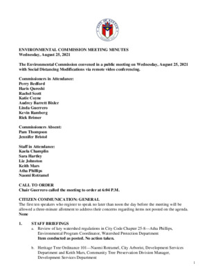
ENVIRONMENTAL COMMISSION MEETING MINUTES Wednesday, August 25, 2021 The Environmental Commission convened in a public meeting on Wednesday, August 25, 2021 with Social Distancing Modifications via remote video conferencing. Commissioners in Attendance: Perry Bedford Haris Qureshi Rachel Scott Katie Coyne Audrey Barrett Bixler Linda Guerrero Kevin Ramberg Rick Brimer Commissioners Absent: Pam Thompson Jennifer Bristol Staff in Attendance: Kaela Champlin Sara Hartley Liz Johnston Keith Mars Atha Phillips Naomi Rotramel CALL TO ORDER Chair Guerrero called the meeting to order at 6:04 P.M. CITIZEN COMMUNICATION: GENERAL The first ten speakers who register to speak no later than noon the day before the meeting will be allowed a three-minute allotment to address their concerns regarding items not posted on the agenda. None 1. STAFF BRIEFINGS a. Review of key watershed regulations in City Code Chapter 25-8—Atha Phillips, Environmental Program Coordinator, Watershed Protection Department Item conducted as posted. No action taken. b. Heritage Tree Ordinance 101—Naomi Rotramel, City Arborist, Development Services Department and Keith Mars, Community Tree Preservation Division Manager, Development Services Department 1 2. Item conducted as posted. No action taken. ITEMS FOR DISCUSSION a. Discuss returning to in-person meetings in September and pilot program for hybrid meetings Item conducted as posted. No action taken. b. Refresher on boards and commissions rules Item conducted as posted. No action taken. c. Review the purview of the Environmental Commission Item conducted as posted. No action taken. d. Discuss the Environmental Commission’s goals and objectives for the new calendar year (July 1, 2021 through June 30, 2022) Item conducted as posted. No action taken. ADJOURNMENT Chair Guerrero adjourned the meeting at 9:04 P.M. The City of Austin is committed to compliance with the American with Disabilities Act. Reasonable modifications and equal access to communications will be provided upon request. Meeting locations are planned with wheelchair access. If requiring Sign Language Interpreters or alternative formats, please give notice at least 2 days before the meeting date. Please call Kaela Champlin at Watershed Protection Department, at (512) 974-3443 for additional information; TTY users route through Relay Texas at 711. For more information on the Environmental Commission, please contact Kaela Champlin, Watershed Protection Department, at (512) 974-3443. * A member of the public may not address a board or commission at a meeting on an item posted as a briefing, per City Code Section 2-1-144(E). 2

Versión en español a continuación. Environmental Commission Regular Meeting August 18, 2021 Environmental Commission to be held August 18, 2021 with Social Distancing Modifications. Public comment will be allowed via telephone; no in-person input will be allowed. All speakers must register in advance (August 17, 2021 by noon). All public comment will occur at the beginning of the meeting. To speak remotely at the August 18, 2021 Environmental Commission Regular Meeting, members of the public must: •Call or email the board liaison Kaela Champlin, (512) 974-3443, Kaela.Champlin@austintexas.gov, no later than noon, (the day before the meeting). The following information is required: speaker name, item number(s) they wish to speak on, whether they are for/against/neutral, email address and telephone number (must be the same number that will be used to call into the meeting). •Once a request to speak has been made to the board liaison, the information to call on the day of the scheduled meeting will be provided either by email or phone call. •Speakers must call in at least 15 minutes prior to meeting start time in order to speak, late callers will not be accepted and will not be able to speak. •Speakers will be placed in a queue until their time to speak. •Handouts or other information may be emailed to Kaela.Champlin@austintexas.gov by noon the day before the scheduled meeting. This information will be provided to Board and Commission members in advance of the meeting. •If the meeting is broadcast live, it may be viewed here: http://www.austintexas.gov/page/watch-atxn- live 1 Reunión del Environmental Commission FECHA de la reunion (18 de agosto de 2021) La junta se llevará con modificaciones de distanciamiento social Se permitirán comentarios públicos por teléfono; no se permitirá ninguna entrada en persona. Todos los oradores deben registrarse con anticipación (17 de agosto de 2021 antes del mediodía). Todos los comentarios públicos se producirán al comienzo de la reunión. Para hablar de forma remota en la reunión, los miembros del público deben: • Llame o envíe un correo electrónico al enlace de la junta en Kaela Champlin, (512) 974-3443, Kaela.Champlin@austintexas.gov a más tardar al mediodía (el día antes de la reunión). Se requiere la siguiente información: nombre del orador, número (s) de artículo sobre el que desean hablar, si están a favor / en contra / neutral, dirección de correo electrónico (opcional) y un número de teléfono (debe ser el número que se utilizará para …
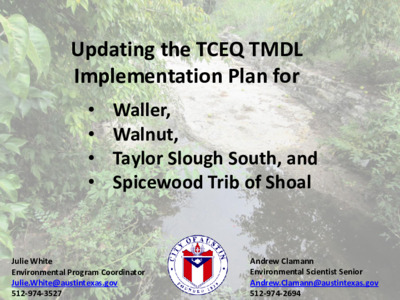
Updating the TCEQ TMDL Implementation Plan for • Waller, • Walnut, • Taylor Slough South, and • Spicewood Trib of Shoal Julie White Environmental Program Coordinator Julie.White@austintexas.gov 512-974-3527 Andrew Clamann Environmental Scientist Senior Andrew.Clamann@austintexas.gov 512-974-2694 This is not my beautiful creek! You may ask yourself: How did we get here? Water quality monitoring data submitted to the State If data indicates impairment, then the stream is placed on the "303(d)* list" * Clean Water Act Section 303(d) requires states to regularly identify water bodies that do not meet water quality standards ** TMDL (Total Maximum Daily Load): a program to analyze data with goal to resolve issue State develops a TMDL** with an Implementation Plan aka "IPlan" You may ask yourself: My God, what's an IPLAN? • A set of strategies to achieve the goal of pollution reduction outlined in the TMDL • Facilitated by TCEQ staff • Developed by stakeholders • 5year implementation period (+ revisions) An I-plan outlines: • What the community will do over the next five years • Who will do it • When they will do it • How we will gauge improvement Currently there are 5 Austin watersheds with IPlans (due to bacteria impairment) IPlan approved in 2011, revised 2017 Gilleland Waller Walnut Taylor Slough South Spicewood Trib of Shoal IPlan for 4 urban watersheds approved in 2015, expired* in 2020, now require revision *IPlans have 5-year approval periods after which they are reviewed and revised (if necessary) The 2015-2020 IPlan for 4 Austin urban creeks 5 primary voluntary strategies • Protect and restore riparian areas • Maintain wastewater infrastructure – includes OSSF, adding public toilets • Improve domestic pet waste management • Education/ public outreach to engage citizens • Improve management of stormwater MS4 Permit & Stormwater Management Program (SWMP) • Population triggered regulatory permit designed to reduce pollutant discharges into city stormwater conveyances. • Develop and implement a plan and submit accomplishments to the TCEQ annually • Periodic audits by TCEQ or EPA Measures to reduce stormwater pollution aka Minimum Control Measures (MCMs) 1. MS4 Maintenance Activities 2. Post-Construction Storm Water Control Measures 3. Illicit Discharge Detection and Elimination 4. Pollution Prevention/Good Housekeeping for Municipal Operations 5. Industrial and High Risk Runoff 6. Construction Site Storm Water Runoff 7. Public Education and Involvement 8. Monitoring Programs I thought we were talking about I-plans? TMDL measures (previously voluntary) are now required to be …

Youth Education Elementary, Middle and High School COVID Pandemic School Year 2020-2021 Education Programs Covid-19 Response Teachers pivoted to a VIRTUAL FORMAT: teaching to a camera, interacting with students as a host via Zoom and performing the role of videographer. Equipment identified and acquired to teach virtually in the field. Two more Teaching Videos produced to add to the ten videos produces in April/May 2020. All videos uploaded to the City of Austin YouTube Channel. Lessons were recreated and rewritten for a VIRTUAL LIVE presentation. Kahoot games created for lessons. Fun timers and Wheel of Names for prizes to promote student participation. Hands-on materials for LIVE interactions delivered to schools. . Fifth grade Virtual Earth Camp 1047 students from 19 schools • • LIVE Zoomed from the Field Interactive Lessons Students made paper watersheds Student Ethnicity Mapped their school’s watershed Used a hairnet to simulate a helmet to enter a cave of the aquifer virtually Mixed Ethnicity/Other 2% White 7% Asian/Pacific Islander 3% Black 9% Hispanic 79% Planted seeds. Fifth grade Virtual Earth School 1463 students from 16 schools Student Ethnicity Hispanic 32% White 52% Mixed Ethnicity/Other 5% Black 3% Asian/Pacific Islander 8% Put photos here LIVE classroom Zoom Interactive Lesson • Paper Watershed Model Activity • Aquifer & Watershed Model Demonstrations • Breakout Room Discussions about Pollution & Solutions • Flood Safety Awareness Presentation Elementary & Middle school Virtual Clean Creek Campus 1,376 students from 14 schools LIVE, in the field and classroom, Zoom Interactive Lessons for CLEAN CREEK CAMPUS Langford 5th grade teacher: “Being able to go on a virtual field trip this year was a real treat for the students. Honestly, it increased participation in zoom classes. The virtual field trip was the highlight for sure! The educators did a really good job answering students' questions on the spot and allowing for a lot of class participation to maintain engagement throughout. It was fantastic!” Middle School Watershed Detectives cancelled due to COVID Partnered with CaveSim to deliver virtual programming to 1008 students 3 middle schools and 3 elementary schools Student Ethnicity Mixed Ethnicity/Other 1% Asian/Pacific Islander 4% Black 6% White 15% Hispanic 74% High School Hydrofiles cancelled due to COVID Participated in Barton Springs University Virtual Presentation – 29 students Partnered with PARD Ranger Cadet Program High school Austin Youth River Watch 49 students Pandemic Adjusted Goals: Virtual Program Delivery Materials Delivered Small Group Virtual …
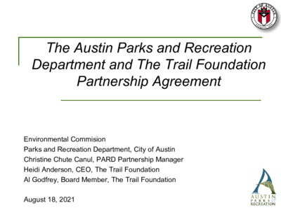
The Austin Parks and Recreation Department and The Trail Foundation Partnership Agreement Environmental Commision Parks and Recreation Department, City of Austin Christine Chute Canul, PARD Partnership Manager Heidi Anderson, CEO, The Trail Foundation Al Godfrey, Board Member, The Trail Foundation August 18, 2021 The Trail Foundation 2 The Trail Foundation (TTF) A 501(c)3 dedicated to protecting, enhancing, and connecting the Butler Hike-and-Bike Trail at Lady Bird Lake for the benefit of all. TTF/City of Austin Partnership Timeline 1971 – Public-private civic effort formed led by the Citizen’s Committee for a More Beautiful Town Lake 2003 – Town Lake Trail Foundation (now The Trail Foundation) was formed to continue the work of the Citizen’s Committee and ensure that the Trail remains one of Austin’s outstanding places 2014 – Boardwalk opens, completes the 10+ mile loop of the Ann and Roy Butler Trail 2015 – TTF adopted the Butler Trail at Lady Bird Lake Urban Forestry and Natural Areas Management Guidelines, developed by Siglo Group in consultation with TTF, Austin Parks and Recreation (PARD) and the City of Austin Watershed Protection Department (WPD). 2018 – PARD and TTF begin discussions to formalize partnership 2020 – Formal process begins to enter into phased Parkland Operations & Maintenance Agreement (POMA) with PARD 3 TTF Investment & Public Benefit Since 2003, TTF has invested more than $17,550,000 on the Butler Trail and the Town Lake Metro Park, including infrastructure projects, ecological restoration, and maintenance. Pre-pandemic (2019) Annual TTF Investment: $3,319,731 Volunteer Impact Since January 2017: 219 Volunteer Events 3,988 Volunteers 15,687 Sapling Trees Planted 1,588 Yards of Mulch/compost Spread 59.4 Acres of Wildflowers Planted ...In addition to an increasingly robust volunteer impact program. Just this year, 400+ bags of trash were collected and 71 screech owl nest boxes were made and installed. 4 Council Resolution - 20200312-041 BE IT RESOLVED BY THE CITY COUNCIL OF THE CITY OF AUSTIN: The City Council expresses support for the concept of parkland agreements between nonprofit organizations and PARD if the agreements further the mission And vision of the department with regard to non- enterprise fund public parks and trails in an effective, efficient, and inclusive manner. BE IT RESOLVED: The City Council directs the City Manager to work with parks nonprofit partners that have established relationships with PARD, including but not limited to The Trail Foundation and …
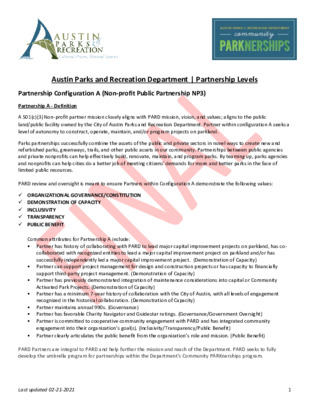
Austin Parks and Recreation Department | Partnership Levels Partnership Configuration A (Non-profit Public Partnership NP3) Partnership A - Definition A 501(c)(3) Non-profit partner mission closely aligns with PARD mission, vision, and values; aligns to the public land/public facility owned by the City of Austin Parks and Recreation Department. Partner within configuration A seeks a level of autonomy to construct, operate, maintain, and/or program projects on parkland. Parks partnerships successfully combine the assets of the public and private sectors in novel ways to create new and refurbished parks, greenways, trails, and other public assets in our community. Partnerships between public agencies and private nonprofits can help effectively build, renovate, maintain, and program parks. By teaming up, parks agencies and nonprofits can help cities do a better job of meeting citizens' demands for more and better parks in the face of limited public resources. PARD review and oversight is meant to ensure Partners within Configuration A demonstrate the following values: ✓ ORGANIZATIONAL GOVERNANCE/CONSTITUTION ✓ DEMONSTRATION OF CAPACITY ✓ INCLUSIVITY ✓ TRANSPARENCY ✓ PUBLIC BENEFIT Common attributes for Partnership A include: • Partner has history of collaborating with PARD to lead major capital improvement projects on parkland, has co- collaborated with recognized entities to lead a major capital improvement project on parkland and/or has successfully independently led a major capital improvement project. (Demonstration of Capacity) • Partner can support project management for design and construction projects or has capacity to financially support third-party project management. (Demonstration of Capacity) • Partner has previously demonstrated integration of maintenance considerations into capital or Community Activated Park Projects. (Demonstration of Capacity) • Partner has a minimum 7-year history of collaboration with the City of Austin, with all levels of engagement recognized in the historical collaboration. (Demonstration of Capacity) • Partner maintains annual 990s. (Governance) • Partner has favorable Charity Navigator and Guidestar ratings. (Governance/Government Oversight) • Partner is committed to cooperative community engagement with PARD and has integrated community engagement into their organization’s goal(s). (Inclusivity/Transparency/Public Benefit) • Partner clearly articulates the public benefit from the organization’s role and mission. (Public Benefit) PARD Partners are integral to PARD and help further the mission and reach of the Department. PARD seeks to fully develop the umbrella program for partnerships within the Department’s Community PARKnerships program. Last updated 02-21-2021 1 Partnership A - Criteria This level of partnership requires a formal partnership review process. The review process will take up …
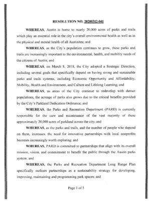
RESOLUTION NO. 20200312-041 WHEREAS, Austin is home to nearly 20,000 acres of parks and trails which play an essential role in the city's overall environmental health as well as in the physical and mental health of all Austinites; and WHEREAS, as the City's population continues to grow, these parks and trails are increasingly important to the environmental, health, and mobility needs of the citizens of Austin; and WHEREAS, on March 8, 2018, the City adopted a Strategic Direction, including several goals that specifically depend on having strong and sustainable including Economic Opportunity and Affordability, parks and trails systems, Mobility, Health and Environment, and Culture and Lifelong Learning; and WHEREAS, as areas of the City continue to redevelop with denser populations, the acreage of parks also grows due to the critical benefits provided by the City' s Parkland Dedication Ordinance; and WHEREAS, the Parks and Recreation Department (PARD) is currently these the vast majority of responsible for approximately 20,000 acres of parkland across the city; and the care and maintenance of WHEREAS, as the parks and trails, and the number of people who depend the need for innovative partnerships with local nonprofits increases, on them, becomes increasingly worth exploring; and WHEREAS, PARD is committed to partnerships that align with its overall mission, vision, and commitment to benefit the public through the Austin parks system; and WHEREAS, the Parks and Recreation Department Long Range Plan specifically outlines partnerships as a sustainability strategy for developing, improving, maintaining and programming park spaces; and Page 1 of 3 WHEREAS, PARD works with nonprofit organizations, conservancies, increase community groups, and businesses to enhance and improve parks, recreational and cultural opportunities, and preserve natural areas in Austin; and WHEREAS, the goals of these partnerships are to enhance and expand public use of PARD's grounds and facilities; encourage active recreation and healthy lifestyles; improve environmental stewardship through public participation and education; celebrate arts, culture, and history to build community; and maximize public benefit at minimum taxpayer cost; and WHEREAS, many peer cities such as Dallas, Houston, Chicago, New York City, and others have negotiated partnerships with nonprofit organizations dedicated to the maintenance and stewardship of particular parks; and WHEREAS, nonprofit organizations dedicated to improving parks and open space for the benefit of the community often have the ability to fundraise and other opportunities that municipalities do not have; and WHEREAS, in Austin, some nonprofits have already begun partnering …
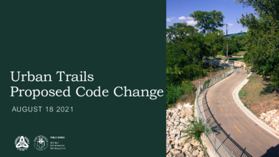
Urban Trails Proposed Code Change AUGUST 18 2021 Agenda 8.18.2021 I. Background #EFA160 #16362F II. Proposed Code Changes LDC 25-8-341/342 I. II. LDC 25-1-261(B)(3)(c) #1886CA III. Q&A PUBLIC WORKS DEPARTMENT – CITY OF AUSTIN 2 Background Resolution NO. 20200220-045 ] PUBLIC WORKS DEPARTMENT – CITY OF AUSTIN 3 Background February 2020 April 2020 • Resolution NO. 20200220-045 Passed • Stakeholder Group Convened January 2021 #EFA160 • Memo response to Resolution June 2021 #16362F • Resolution NO. 20210610-041 Passed Resolution NO. 20210610-041 #1886CA “(2) Council initiates the following amendments to the Land Development Code, as recommended by PWD and WPD in Appendix B of the January 4, 2021 memo from PWD, and asks that they be brought back to Council by August 26, 2021: (a) Amend Land Development Code 25-8-341 and 25-8-342 to grant urban trails projects greater cut and fill allowances under specific environmental circumstances. (b) Amend Land Development Code 25-8-261(B)(3)(c) to reflect current policy that trails within the critical water quality zone be limited to 12 feet in surface width plus one-foot shoulders on each side. PUBLIC WORKS DEPARTMENT – CITY OF AUSTIN 4 PURPOSE • Streamline review process • Create transparency • Formalize internal policy LDC 25-8-341 & 25-8-342: Cut and Fill Current Status: Cut and/or fill in a suburban watershed is limited to 4 ft in depth Administrative variance typically granted to allow up to 8 ft, with certain conditions Construction of roadways in public right-of-way has no cut or fill limit Proposed Improvement #EFA160 #16362F Allow cut and/or fill of up to 8 ft for a public trail if: The cut or fill is not located on a slope of more than 15% The cut or fill is not located within 100 #1886CA ft of a classified waterway; and The trail is constructed in accordance with the Environmental Criteria Manual. PUBLIC WORKS DEPARTMENT – CITY OF AUSTIN 6 NORTHERN WALNUT CREEK TRAIL Northern Walnut Creek Trail Phase 2A • Construction beginning November 2021 • Granted admin variance from cut and fill requirements LDC 25-8-261: Critical Water Quality Zone Development Current Status: A hard surface trail within the critical water quality zone is limited to 12 feet in width, unless a wider trail is designated in a Council adopted plan. Current language does not make clear if the 12 ft refers to the surface width or if it includes …
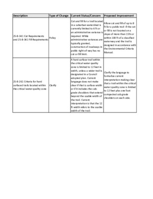
Description Type of Change Current Status/Concern Proposed Improvement 25-8-341 Cut Requirements and 25-8-341 Fill Requirements Policy 25-8-261 Criteria for hard surfaced trails located within the critical water quality zone Clarify Cut and fill for a trail located in a suburban watershed is currently limited to 4 ft or an administrative variance is required. While administrative variances are typically granted, construction of roadways in public right-of-way has no cut or fill limit. A hard surface trail within the critical water quality zone is limited to 12 feet in width, unless a wider trail is designated in a Council adopted plan. Current language does not make clear if that is surface width or if it includes the sub- grade shoulders that extend beyond the usable width of the trail. Current interpretation is that the 12 ft width refers to the usable width of the trail. Allow cut and fill of up to 8 ft for a public trail if the cut or fill is not located on a slope of more than 15% or within 100 ft of a classified waterway and the trail is designed in accordance with the Environmental Criteria Manual. Clarify the language to formalize current interpretation making clear that a trail within the critical water quality zone is limited to 12 feet plus one foot compacted sub grade shoulders on each side. Advantage Disadvantage Streamlines review process. None Formalizes internal policy. None
Play video
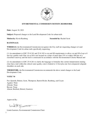
1 ENVIRONMENTAL COMMISSION MOTION 20210818 004b Date: August 18, 2021 Seconded by: Rachel Scott Subject: Proposed changes to the Land Development Code for urban trails Motion by: Kevin Ramberg RATIONALE: WHEREAS, the Environmental Commission recognizes the City staff are requesting changes to Land Development Code for urban trails specifically requesting: (1) An amendment to LDC 25-8-341 and 25-8-342 to cut and fill requirements to allow cut and fill of up to 8 feet for a public trail if the cut or fill is not located on a slope of more than 15% or within 100 feet of a classified waterway and the trail is constructed in accordance with the Environmental Criteria Manual and (2) An amendment to LDC 25-8-261 to clarify the language to formalize the current interpretation making clear that a trail within the critical water quality zone is limited to 12 feet plus one foot compacted subgrade shoulders on each side. THEREFORE, the Environmental Commission recommends the above noted changes to the Land Development Code. VOTE 7-0 For: Qureshi, Brimer, Scott, Thompson, Barrett Bixler, Ramberg, and Coyne Against: None Abstain: None Recuse: None Absent: Bedford, Bristol, Guerrero Approved By: Linda Guerrero, Environmental Commission Chair
ENVIRONMENTAL COMMISSION MEETING MINUTES Wednesday, August 18, 2021 The Environmental Commission convened in a public meeting on Wednesday, August 18, 2021 with Social Distancing Modifications via remote video conferencing. Commissioners in Attendance: Pam Thompson Audrey Barrett Bixler Rick Brimer Kevin Ramberg Katie Coyne Rachel Scott Haris Qureshi Commissioners Absent: Jennifer Bristol Perry Bedford Linda Guerrero Staff in Attendance: Christine Canal Chute Kaela Champlin Andrew Clamann Sara Hartley Liz Johnston Jorge Morales Katie Wettick Julie White CALL TO ORDER Vice Chair Coyne called the meeting to order at 6:00 P.M. CITIZEN COMMUNICATION: GENERAL The first ten speakers who register to speak no later than noon the day before the meeting will be allowed a three-minute allotment to address their concerns regarding items not posted on the agenda. None 1. ENVIRONMENTAL COMMISSION UPDATES a. Recognize Andrew Creel for 6 years of service on the Environmental Commission (5 minutes) Item conducted as posted. No action taken. 1 2. 3. 4. b. New Environmental Commission member welcome and introduction (5 minutes) Item conducted as posted. No action taken. APPROVAL OF MINUTES AND ACTION a. Approval of the August 4, 2021 Environmental Commission Meeting Minutes (5 minutes) A motion to approve the August 4, 2021 Environmental Commission Meeting Minutes was approved on Commissioner Ramberg’s motion, Commissioner Brimer’s second on a 6-0 vote. Commissioner Scott were off the dais. Commissioners Bristol, Bedford, and Guerrero were absent. BRIEFINGS a. Update on School Year 2020-2021 WPD Youth Education Report—Susan Wall, Conservation Program Coordinator, Watershed Protection Department (15 minutes) Item conducted as posted. No action taken. b. Updating the Texas Commission on Environmental Quality (TCEQ) Total Maximum Daily Load (TMDL) Implementation Plan for Waller, Walnut, Taylor Slough South, and the Spicewood Tributary of Shoal Creek—Julie White, Environmental Program Coordinator and Andrew Clamann, Environmental Scientist Senior, Watershed Protection Department (30 minutes) Item conducted as posted. No action taken. ITEMS FOR CONSIDERATION AND POSSIBLE ACTION a. Joint presentation on the Programing, Operations and Maintenance Agreement between the Parks and Recreation Department (PARD) and The Trail Foundation (TTF)— Christine Canal Chute, Program Manager II, PARD, Heidi Anderson, CEO, TTF and Al Godfrey, TTF Board Member (30 minutes) Commissioner Coyne recused on Item 4a. Item conducted as posted. No action taken. b. Discuss and consider proposed changes to the Land Development Code for Urban Trails including: 1. Amendment to LDC 25-8-341 and 25-8-342 to cut and fill requirements to allow cut and fill …
Versión en español a continuación. Environmental Commission Regular Meeting August 4, 2021 Environmental Commission to be held August 4, 2021 with Social Distancing Modifications. Public comment will be allowed via telephone; no in-person input will be allowed. All speakers must register in advance (August 3, 2021 by noon). All public comment will occur at the beginning of the meeting. To speak remotely at the August 4, 2021 Environmental Commission Regular Meeting, members of the public must: •Call or email the board liaison Kaela Champlin, (512) 974-3443, Kaela.Champlin@austintexas.gov, no later than noon, (the day before the meeting). The following information is required: speaker name, item number(s) they wish to speak on, whether they are for/against/neutral, email address and telephone number (must be the same number that will be used to call into the meeting). •Once a request to speak has been made to the board liaison, the information to call on the day of the scheduled meeting will be provided either by email or phone call. •Speakers must call in at least 15 minutes prior to meeting start time in order to speak, late callers will not be accepted and will not be able to speak. •Speakers will be placed in a queue until their time to speak. •Handouts or other information may be emailed to Kaela.Champlin@austintexas.gov by noon the day before the scheduled meeting. This information will be provided to Board and Commission members in advance of the meeting. •If the meeting is broadcast live, it may be viewed here: http://www.austintexas.gov/page/watch-atxn- live 1 Reunión del Environmental Commission FECHA de la reunion (4 de agosto de 2021) La junta se llevará con modificaciones de distanciamiento social Se permitirán comentarios públicos por teléfono; no se permitirá ninguna entrada en persona. Todos los oradores deben registrarse con anticipación (3 de agosto de 2021 antes del mediodía). Todos los comentarios públicos se producirán al comienzo de la reunión. Para hablar de forma remota en la reunión, los miembros del público deben: • Llame o envíe un correo electrónico al enlace de la junta en Kaela Champlin, (512) 974-3443, Kaela.Champlin@austintexas.gov a más tardar al mediodía (el día antes de la reunión). Se requiere la siguiente información: nombre del orador, número (s) de artículo sobre el que desean hablar, si están a favor / en contra / neutral, dirección de correo electrónico (opcional) y un número de teléfono (debe ser el número que se utilizará para …
Annual Internal Review This report covers the time period of 7/1/2020 to 6/30/2021 Environmental Commission __ (Official Name of Board or Commission) The Board/Commission mission statement (per the City Code) is: Per section 2-1-144(F) of the City Code, the Environmental Commission may: 1) review and analyze the policies relating to the environmental quality of the city; (2) act as an advisory board to the city council, the city manager, and the department in their efforts to oversee the protection and integrity of the natural environment; (3) promote growth management and land use planning, minimize degradation of water resources, protect downstream areas, and promote recreation opportunities and environmental awareness; and (4) advise and recommend on any issue which the commission determines necessary or advisable for the enhancement and stewardship of the urban forest both public and private. (G) The commission shall: (1) assist the city council, the city manager, and the department in studying, promoting and enforcing environmental protection policies to assure the health, safety, welfare and quality of life of all citizens within the City's incorporated boundaries as well as those within its extraterritorial jurisdiction where the boundaries apply; and (2) oversee the development and implementation of a comprehensive plan for the planting, maintenance, and replacement of trees in the City's jurisdiction, and revise the plan as necessary. When a portion of the plan has been developed and established, it shall be submitted to the city council for adoption before implementation. (H) The commission shall advise the city council, the city manager, and the department concerning policies, projects, and programs that affect the quality of life or have the potential to affect the environment, including those that relate to or affect: (1) water quality: (a) watershed protection; (b) urban runoff; (c) innovative wastewater treatment; (d) regional wastewater treatment; (e) improvement and protection of the Colorado River and the Edwards Aquifer; and (f) wastewater irrigation; Annual Review and Work Plan 7/1/2020 to 6/30/2021 Page 2 (2) growth management and land use planning: (a) municipal utility district review; (b) capital improvement project review; and (c) the comprehensive plan; (3) construction controls for erosion and sedimentation; (4) City environmental policies regarding monitoring and enforcement; (5) solid waste disposal plan alternatives; (6) watershed protection: (a) flood control; (b) erosion control; (c) water quality; and (d) utility management; (7) roadway planning; (8) beautification; (9) recreation resources; (10) public education on environmental matters; (11) hazardous waste …
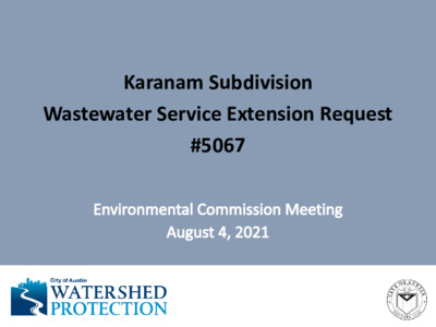
Karanam Subdivision Wastewater Service Extension Request #5067 Request Summary • Request for wastewater service (2 LUEs) • 0.62 acres • Redevelopment of a single-family home into two single family homes on two separate lots • Limited purpose jurisdiction • Drinking Water Protection Zone (DWPZ) • Bull Creek Watershed, Water Supply Suburban • Edwards Aquifer Recharge Zone • Council District #10 SER #5067 Site Location Austin City Limits Austin ETJ Edwards Aquifer Recharge Zone Edwards Aquifer Contributing Zone Austin City LimitsETJRechargeContributingAustin City LimitsETJRechargeContributing Site Location SER #5067 Proposed Wastewater Extension Map provided by AWU SER #5067 Description of proposed extension: • Decommission the existing OSSF • Construct 400 feet of low pressure force main from the existing 8-inch gravity wastewater main located in Nashfara Cove, and • extend west along Nashfara Cove, and then south along D K Ranch Road to the subject tract. SER Review & Evaluation • Bull Creek Watershed, Water Supply Suburban, Edwards Aquifer Recharge Zone • No critical environmental features, wetlands, or recharge features on site • No critical water quality zone or water quality transition zone • Drains to known Jollyville Plateau salamander (Eurycea sosorum) habitat Staff Recommendation Staff recommends approval. Basis for recommendation: Staff review determined that there are no significant environmental risks to extend service to the site. Contact Information Kaela Champlin Watershed Protection Department City of Austin (512) 974-3443 kaela.champlin@austintexas.gov
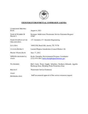
ITEM FOR ENVIRONMENTAL COMMISSION AGENDA COMMISSION MEETING DATE: August 4, 2021 NAME & NUMBER OF PROJECT: Karanam Subdivision Wastewater Service Extension Request #5067 NAME OF APPLICANT OR ORGANIZATION: I.T. Gonzalez, I.T. Gonzalez Engineering LOCATION: 10802 D K Ranch Rd, Austin, TX 78759 COUNCIL DISTRICT: Limited Purpose Jurisdiction (Council District 10) PROJECT FILING DATE: June 17, 2021 WPD/ENVIRONMENTAL STAFF: Kaela Champlin, Environmental Program Coordinator (512) 974-3443, kaela.champlin@austintexas.gov WATERSHED: REQUEST: STAFF DETERMINATION: Bull Creek, Water Supply Suburban, Northern Edwards Aquifer Recharge Zone, Drinking Water Protection Zone Wastewater Service Extension Staff recommend approval of this service extension request. MEMORANDUM July 28, 2021 Linda Guerrero, Chair, and Members of the Environmental Commission Kaela Champlin, Environmental Program Coordinator Watershed Protection Department TO: FROM: DATE: SUBJECT: Karanam Subdivision Wastewater Service Extension Request #5067 Service Extension Requests (SER) located in the Drinking Water Protection Zone and outside of the City of Austin’s full purpose jurisdiction require Council approval and review by the Environmental Commission. Watershed Protection Department staff have completed the review for Karanam Subdivision Wastewater Service Extension Request (SER) #5067 and recommend approval of the request. Site Overview The site consists of a tract of approximately 0.62 acres, located at 10802 D-K Ranch Road. The property is located in the City of Austin Limited Purpose Jurisdiction and Council District 10. The site is in the Bull Creek Watershed, Water Supply Suburban, the Drinking Water Protection Zone, and the Northern Edwards Aquifer Recharge Zone. The applicant is proposing to redevelop a single-family home into two single family homes on two separate lots. A site plan has not yet been submitted to the City of Austin at the time that staff reviewed this SER. The site is currently utilizing an On-Site Sewage Facility (OSSF) and is proposing a wastewater SER with two Living Unit Equivalents (LUEs). Development Impacts Water: The site is located in the Austin Water Service Area. Wastewater: The SER proposes that the applicant construct approximately 400 feet of appropriately sized low pressure force main from the existing 8-inch gravity wastewater main located in Nashfara Cove, and extend west along Nashfara Cove, and then south along D K Ranch Road to the subject tract, as approximately shown on the attached map. 1 Alternative Wastewater Service: Under Travis County Chapter 448.032(c)(1), each residential unit served by an OSSF is considered a separate structure. Multiple residential units may be on a single lot or site only if the …