Environmental Commission Regular Meeting of the Environmental Commission - Remote meeting to be held with social distancing modifications. See agenda for details.
Versión en español a continuación. Environmental Commission Regular Meeting February 17, 2021 Environmental Commission to be held February 17, 2021 with Social Distancing Modifications. Public comment will be allowed via telephone; no in-person input will be allowed. All speakers must register in advance (February 16, 2021 by noon). All public comment will occur at the beginning of the meeting. To speak remotely at the February 17, 2021 Environmental Commission Regular Meeting, members of the public must: •Call or email the board liaison Kaela Champlin, (512) 974-3443, Kaela.Champlin@austintexas.gov, no later than noon, (the day before the meeting). The following information is required: speaker name, item number(s) they wish to speak on, whether they are for/against/neutral, email address and telephone number (must be the same number that will be used to call into the meeting). •Once a request to speak has been made to the board liaison, the information to call on the day of the scheduled meeting will be provided either by email or phone call. •Speakers must call in at least 15 minutes prior to meeting start time in order to speak, late callers will not be accepted and will not be able to speak. •Speakers will be placed in a queue until their time to speak. •Handouts or other information may be emailed to Kaela.Champlin@austintexas.gov by noon the day before the scheduled meeting. This information will be provided to Board and Commission members in advance of the meeting. •If the meeting is broadcast live, it may be viewed here: http://www.austintexas.gov/page/watch-atxn- live 1 Reunión del Environmental Commission FECHA de la reunion (17 de febrero de 2021) La junta se llevará con modificaciones de distanciamiento social Se permitirán comentarios públicos por teléfono; no se permitirá ninguna entrada en persona. Todos los oradores deben registrarse con anticipación (16 de febrero de 2021 antes del mediodía). Todos los comentarios públicos se producirán al comienzo de la reunión. Para hablar de forma remota en la reunión, los miembros del público deben: • Llame o envíe un correo electrónico al enlace de la junta en Kaela Champlin, (512) 974-3443, Kaela.Champlin@austintexas.gov a más tardar al mediodía (el día antes de la reunión). Se requiere la siguiente información: nombre del orador, número (s) de artículo sobre el que desean hablar, si están a favor / en contra / neutral, dirección de correo electrónico (opcional) y un número de teléfono (debe ser el número que se utilizará para …
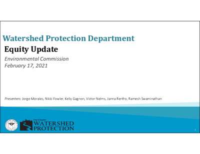
Watershed Protection Department Equity Update Environmental Commission February 17, 2021 Presenters: Jorge Morales, Nikki Fowler, Kelly Gagnon, Victor Nelms, Janna Renfro, Ramesh Swaminathan 1 WPD Equity Timeline Council resolution directs creation of Equity Assessment Tool 1st cohort of departments begin Equity Assessment Watershed Action Planning Watershed – Building Institutional Infrastructure and Capacity Austin hires 1st Chief Equity Officer + Creates Equity Office Watershed Equity Assessment Watershed Implementation – Teams, Training, Relationships 2 Guiding Principles • Shared definition of equity: ◦ Racial equity is the condition when race is no longer a predictor of quality of life outcomes in our community. • Lead with Race: ◦ Race is the most reliable predictor of quality of life in Austin. • Transformation, not transaction. • Normalize. Organize. Operationalize. 3 Watershed Focus Drinking Water Protection Zone Desired Development Zone High SVI Low SVI Edwards Plateau Blackland Prairie Transition Line SVI = Social Vulnerability Index as defined by the Center for Disease Control (CDC) 4 2018 Equity Assessment Process EQUITY ASSESSMENT TOOL Departmental Analysis Budget Engagement Strategic Outcomes WATERSHED FOCUS AREAS INTERNAL EQUITY DATA PRIORITIZATION ENGAGEMENT 5 • • • Internal Equity People of color primarily work in Operations & Maintenance compared to “office” staff which is whiter. How are power + resources shared between these two spaces? How does quality of life differ? Is Watershed culture inclusive of all? Can we adequately serve the community if we don’t “look” like the community we serve across across all areas? • Are we meeting our full potential as an organization without a diverse professional staff across all areas? 6 Data • Are people of color more likely to face adverse impacts from flooding, erosion, and poor water quality? • How are we collecting data so that it can be disaggregated by race? • What are the best ways to measure, analyze, and predict outcomes related to Watershed mission areas? 7 Prioritization close those gaps? • Once we know where inequity exists, how do we prioritize funding to • How do we make sure our dollars are reaching the right communities? • Are we choosing solutions in a way that considers the different ways in which communities are situated? • How do we improve infrastructure without worsening gentrification? 8 Engagement • How can we expand our model of public participation to fully reflect community values and reach those we have marginalized? • How can we work better …
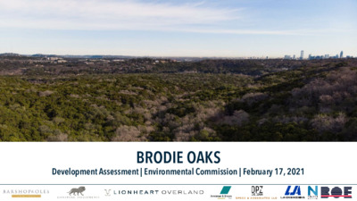
BRODIE OAKS Development Assessment | Environmental Commission | February 17, 2021 PROJECT TEAM • Landowner • Barshop & Oles • Lionstone Investments • Planning & Design Team Lionheart – Planning, Urban Design, & Landscape Architecture • • • Armbrust & Brown – Legal LJA Engineering – Civil, Utilities, Drainage • BOE Consulting – Transportation • Nelson Nygard – Parking Management and Travel Demand • Overland - Architecture • DPZ & Co. – Urban Design • Speck & Associates – Urban Design and Transportation • Terracon – Geotechnical Engineering BRODIE OAKS PROPERTY • 37.6 acres • 3.5 Miles from Downtown • Major intersection of Loop 360, HWY 290, and S. Lamar Boulevard • High-Capacity Transit Route • Barton Creek Greenbelt Brodie Oaks ORIGINAL DEVELOPMENT 1981 • 4 years prior to Hill Country Overlay • 11 years prior to SOS • 31 years prior to Imagine Austin Barton Creek Plaza Gus Fruh Park 84 acres Brodie Oaks Shopping Center Retreat at Barton Creek PROJECT GOALS Ecology Vitality Meet highest environmental standards. Create a walkable mixed-use activity center. Connectivity Connect the site to its surroundings. Character Express the South Austin character. Performance Position the project for the future. SYSTEMS ANALYSIS CONCEPTUAL MASTER PLAN • Comply with SOS Ordinance. • Create destination quality public space (parks and streets). • Develop at Transit-Supportive Densities. • Include a Mix of Uses. • Commit to 10% of Bonus Area as Affordable Housing. The content on these slides is conceptual in nature and is subject to change. The content on these slides is conceptual in nature and is subject to change. The content on these slides is conceptual in nature and is subject to change. The content on these slides is conceptual in nature and is subject to change. THE RESTORATION • Acres of parking lot and buildings converted to green space = 13.7 (36% Of the Site) • Trails and interpretive material provided to educate, engage and connect people with the environment. The content on these slides is conceptual in nature and is subject to change. THE RESTORATION Current Proposed The content on these slides is conceptual in nature and is subject to change. SOS ORDINANCE Impervious Cover = 54% (down from 84%) SOS Pond Size = Sized per SOS Criteria (currently no on-site storage; most flows to ponds at Retreat at Barton Creek) Reirrigation Area* = 10 Acres (currently no recharge) *Reirrigation within Barton Creek Greenbelt …
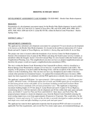
BRIEFING SUMMARY SHEET DEVELOPMENT ASSESSMENT CASE NUMBER: CD-2020-0002 – Brodie Oaks Redevelopment REQUEST: Presentation of a development assessment report for the Brodie Oaks Redevelopment, located at 4021, 4025, 4107, 4109, 4115 and 4141 S. Capital of Texas Hwy NB, and 4220, 4040, 4036, 4006, 4032, 4030, 3940, 4024, 4200 and 4236 S. Lamar BLVD SB, within the Barton Creek Watershed – Barton Springs Zone. DISTRICT AREA: 5 DEPARTMENT COMMENTS: The applicant has submitted a development assessment for a proposed 37.6-acre mixed-use development to be known as the Brodie Oaks Redevelopment. It is located at the northwest intersection of S. Lamar Boulevard and S. Capital of Texas Highway, see Exhibit A: Zoning Map and Exhibit B: Aerial Map. The project site (site) is located within the boundaries of an Activity Center for Redevelopment in Sensitive Environmental Areas (Lamar & Ben White) and along the South Lamar Activity Corridor, as identified within the Imagine Austin’s Growth Concept Map. It is also located within the South Lamar Neighborhood Planning Area. This neighborhood area does not have an adopted neighborhood plan and therefore this project would not require a neighborhood plan amendment (NPA). The site is within the Barton Creek Watershed of the Colorado River Basin, which is classified as a Barton Springs Zone Watershed by Chapter 25-8 of the City’s Land Development Code (LDC). The majority of the property is located within the Recharge Zone, with the exception of the southeast corner which is in the Contributing Zone. This site does not have any floodplain located within it but does contain other potential environmental features. An updated Environmental Resource Inventory (ERI) report has been requested to be submitted with the PUD application to identify these areas and features. The applicant’s proposed PUD plans “for approximately 1,564 residential units, 1,150,678 square feet of office, 448 hotel rooms, 110 thousand square feet of retail, and 30,000 square feet of restaurant uses located along private streets with public access easements including an Internal Circulator Route meeting Great Streets standards with activated ground floor uses.” The Applicant is requesting a maximum building height of 275 feet along S. Lamar Boulevard and S. Capital of Texas Highway, transitioning down to 160 feet internal to the development and 28 feet within their open space and park areas, see Exhibit F: Land Use Plan and Notes and Exhibit G: Open Space and Parks Plan. The proposed project intends to cluster …
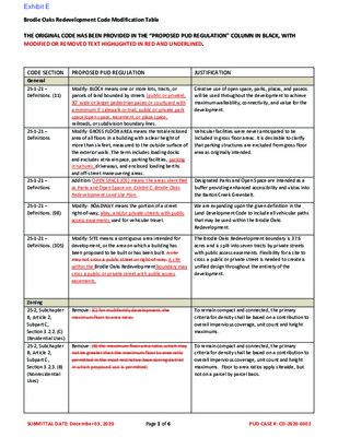
Brodie Oaks Redevelopment Code Modification Table THE ORIGINAL CODE HAS BEEN PROVIDED IN THE “PROPOSED PUD REGULATION” COLUMN IN BLACK, WITH MODIFIED OR REMOVED TEXT HIGHLIGHTED IN RED AND UNDERLINED. CODE SECTION General 25-1-21 – Definitions. (11) 25-1-21 – Definitions 25-1-21 – Definitions 25-1-21 – Definitions. (98) 25-1-21 – Definitions. (105) Zoning 25-2, Subchapter B, Article 2, Subpart C, Section 3.2.2. (C) (Residential Uses) 25-2, Subchapter B, Article 2, Subpart C, Section 3.2.3. (B) (Nonresidential Uses) PROPOSED PUD REGULATION JUSTIFICATION Modify: BLOCK means one or more lots, tracts, or parcels of land bounded by streets (public or private), 30’ wide or larger pedestrian paseo or courtyard with a minimum 5’ sidewalk or trail, public or private park space/open space, easement, or plaza space, railroads, or subdivision boundary lines. Modify: GROSS FLOOR AREA means the total enclosed area of all floors in a building with a clear height of more than six feet, measured to the outside surface of the exterior walls. The term includes loading docks and excludes atria airspace, parking facilities, parking structures, driveways, and enclosed loading berths and off-street maneuvering areas. Addition: OPEN SPACE (OS) means the areas identified as Parks and Open Space on Exhibit C: Brodie Oaks Redevelopment Land Use Plan. Modify: ROADWAY means the portion of a street right-of-way, alley, and/or private streets with public access easements used for vehicular travel. Modify: SITE means a contiguous area intended for development, or the area on which a building has been proposed to be built or has been built. A site may not cross a public street or right-of-way. A site within the Brodie Oaks Redevelopment boundary may cross a public or private street with public access easements. Remove: (C) for multifamily development, the maximum floor to area ratio; Remove: (B) the maximum floor area ratio, which may not be greater than the maximum floor to area ratio permitted in the most restrictive base zoning district in which proposed use is permitted; Creative use of open space, parks, plazas, and paseos will be used throughout the development to achieve maximum walkability, connectivity, and value for the development. Vehicular facilities were never anticipated to be included in gross floor areas. It is desirable to clarify that parking structures are excluded from gross floor area as originally intended. Designated Parks and Open Space are intended as a buffer providing enhanced accessibility and vistas into the Barton Creek Greenbelt. We …
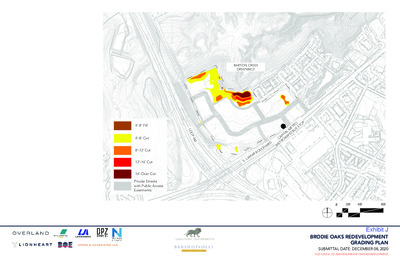
7 0 9 695 696 697 698 700 701 7 0 2 7 0 3 7 0 4 7 0 5 7 0 7 710 1 1 7 L O O P 3 6 0 BARTON CREEK GREENBELT 714 713 711 7 1 2 7 1 3 706 707 708 709 705 706 707 708 709 7 1 1 7 0 9 710 7 0 8 7 0 9 7 0 7 710 711 7 1 1 7 1 0 709 708 710 7 0 9 705 708 706 707 704 703 697 699 700 698 696 702 701 6 9 5 4 9 6 6 9 6 7 9 6 6 9 9 6 9 8 6 9 5 6 9 4 6 9 3 6 9 3 6 9 2 693 700 6 9 2 8 0 7 707 709 706 7 0 5 7 0 9 0 1 7 1 1 7 0 1 7 9 0 7 7 0 8 702 701 703 7 0 4 6 9 8 9 9 6 0 0 7 O U S S T O P 708 707 7 0 6 7 0 3 5 0 7 7 0 4 706 707 705 E T R A PIT A L M R A PID B C E T R O 7 5 0 711 710 709 711 709 710 7 0 8 708 707 706 708 705 701 700 R B A 6 9 5 M A S . L D R M A V E L 7 3 0 0 7 2 7 1 0 0 0 7 U O 4’-8’ Fill 4’-8’ Cut 8’-12’ Cut 12’-16’ Cut 16’-Over Cut Private Streets with Public Access Easements 0 200 400 800 EXHIBIT G: BRODIE OAKS REDEVELOPMENT GRADING PLAN SUBMITTAL DATE: DECEMBER 08, 2020 PUD CASE #: CD-2020-0002-BRODIE OAKS REDEVELOPMENT L O O P 3 6 0 Phase 1 - A portion of Phase I will be temporary restoration of the site for the purposes of reirrigation and revegetation. Future Phases - Future phases will be delivered in response to market conditions. A tracking chart will be provided for all phases of development that accounts for Impervious Cover, Building Coverage, Floor-To-Area, Parkland Credit, and Affordable Housing. BARTON CREEK GREENBELT O U S S T O P E T R A PIT A L M R A PID B C E T …
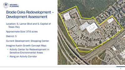
Brodie Oaks Redevelopment – Development Assessment Location: S. Lamar Blvd and S. Capital of Texas Hwy District: 5 Approximate Size: 37.6 acres Current Development: Shopping Center Imagine Austin Growth Concept Map: • Activity Center for Redevelopment in Sensitive Environmental Areas • Along an Activity Corridor 1 Creating a mixed-use development; 13.7 acres of open space; Maximum of building height of 275’. Key Points of Proposed PUD Cluster development near S. Lamar Blvd and S. Capital Texas Hwy; Reduce existing impervious cover. 4,700 feet of active trails with new trailhead to greenbelt; 10,000 feet of sidewalk; Working with transportation groups on improved access. Will meet or exceed all Tier One and several Tier Two Requirements. 2 PUD Zoning Process Next Steps Development Assessment PUD Zoning Application Commission and Council Process We are here in the process. We do not need a recommendation at this point. City Council staff briefing to be scheduled. 3 Barton Creek Critical Water Quality Zone Water Quality Transition Zone Existing Parkland Site Parkland Site Data: Barton Creek Watershed/Barton Springs Zone Edwards Aquifer Recharge Zone
Dougherty Arts Center Replacement Project Preliminary Design Phase Update Boards and Commissions February 2021 Site Map & Context 2 Previous City Council Direction • Butler Shores location approved on 5/9/19 • Council direction to consider site alternatives: on site 1. New DAC & existing PARD Main Office remain 2. New DAC & New PARD Main Office rebuilt on site (unfunded) 3. New DAC on site, existing PARD is removed/relocated elsewhere (unfunded) • Consolidated Arts District Parking (underground, partially unfunded) • Seek alternative financing mechanisms & interest in philanthropy Conceptual development scenario from 2018/2019 planning process 3 Existing PARD Main Office • Constructed 1959, 2-story addition in 1976 • First permanent home for COA Parks Department • High degree of historic integrity • Architect: R. Earl Dillard • Defining features: wide eaves, flat roof, curtain • Eligible for listing on National Register of Historic windows Places Image credits: Austin History Center 4 Recent Stakeholder Engagement • Two Open House Community Meetings • Meeting #1: Oct. 28, 2020 • Meeting #2: Jan. 26, 2021 • (10) Small Group Meetings • Dougherty Arts Center Staff: 11/10/2020 • Painting, Photography, and Drawing Artists and Instructors: 11/19/2020 • Youth Program Instructors and Parents: 12/1/2020 • Gallery Artists: 12/2/2020 • Artist Professional Development Programs: 12/3/2020 • Theater Organizations and Technical Staff: 12/7/2020 • Friends of the Dougherty Arts Center: 12/9/2020 • Ceramics Studio Artists and Instructors: 12/10/2020 • Neighbors to the Dougherty Arts Center: 12/15/2020 • Diversity, Equity, and Inclusion in the Arts: 1/7/2021 • Electronic Survey • 221 Participants & 894 Responses • Ongoing Partner Coordination • ZACH Scott Theater • The Trail Foundation • Austin Transportation Dept. 5 Project Mission Statement 6 Site Constraints Map 7 Four Options Key operational criteria and site considerations • Preservation of heritage trees • Relationship to adjacent ZACH • Underground parking solution • Pick-up & drop-off for youth programs • Load-in areas for theater programs • Balancing traffic impact between Toomey Rd. & Riverside Dr. • Preservation of PARD Main Office (1959) • Allowance for possible expansion • Activates parkland & enhance trail access • Civic presence/identity • Back of house areas for kiln yard, etc. 8 • Compact building footprint tucked closely behind PARD Main & ZACH School • One heritage oak impacted • Proposed parking garage sits between ZACH and new DAC, within ZACH lease boundary • PARD Main is retained and renovated/expanded (future scope, unfunded) …