20210217-004a: CD-2020-0002 Brodie Oaks Redevelopment backup packet 3 of 3 — original pdf
Backup
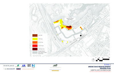
7 0 9 695 696 697 698 700 701 7 0 2 7 0 3 7 0 4 7 0 5 7 0 7 710 1 1 7 L O O P 3 6 0 BARTON CREEK GREENBELT 714 713 711 7 1 2 7 1 3 706 707 708 709 705 706 707 708 709 7 1 1 7 0 9 710 7 0 8 7 0 9 7 0 7 710 711 7 1 1 7 1 0 709 708 710 7 0 9 705 708 706 707 704 703 697 699 700 698 696 702 701 6 9 5 4 9 6 6 9 6 7 9 6 6 9 9 6 9 8 6 9 5 6 9 4 6 9 3 6 9 3 6 9 2 693 700 6 9 2 8 0 7 707 709 706 7 0 5 7 0 9 0 1 7 1 1 7 0 1 7 9 0 7 7 0 8 702 701 703 7 0 4 6 9 8 9 9 6 0 0 7 O U S S T O P 708 707 7 0 6 7 0 3 5 0 7 7 0 4 706 707 705 E T R A PIT A L M R A PID B C E T R O 7 5 0 711 710 709 711 709 710 7 0 8 708 707 706 708 705 701 700 R B A 6 9 5 M A S . L D R M A V E L 7 3 0 0 7 2 7 1 0 0 0 7 U O 4’-8’ Fill 4’-8’ Cut 8’-12’ Cut 12’-16’ Cut 16’-Over Cut Private Streets with Public Access Easements 0 200 400 800 EXHIBIT G: BRODIE OAKS REDEVELOPMENT GRADING PLAN SUBMITTAL DATE: DECEMBER 08, 2020 PUD CASE #: CD-2020-0002-BRODIE OAKS REDEVELOPMENT L O O P 3 6 0 Phase 1 - A portion of Phase I will be temporary restoration of the site for the purposes of reirrigation and revegetation. Future Phases - Future phases will be delivered in response to market conditions. A tracking chart will be provided for all phases of development that accounts for Impervious Cover, Building Coverage, Floor-To-Area, Parkland Credit, and Affordable Housing. BARTON CREEK GREENBELT O U S S T O P E T R A PIT A L M R A PID B C E T R O M D R A V E L U O R B A M A S . L 0 100 200 400 EXHIBIT H: BRODIE OAKS REDEVELOPMENT PHASING PLAN SUBMITTAL DATE: DECEMBER 08, 2020 PUD CASE #: CD-2020-0002-BRODIE OAKS REDEVELOPMENT COMMENT REPORT CASE NUMBER: CD-2020-0002 CASE MANAGER: Kate Clark PROJECT NAME: Brodie Oaks Redevelopment SUBMITTAL DATE: December 18, 2020 REPORT DUE DATE: January 11, 2021 FINAL REPORT DATE: January 27, 2021 REPORT LATE: 10 BUSINESS DAYS LOCATION: 4021, 4025, 4107, 4109, 4115 and 4141 S. Capital of Texas Hwy NB; PHONE #: 512-974-1237 4220, 4040, 4036, 4006, 4032, 4030, 3940, 4024, 4200 and 4236 S. Lamar BLVD SB STAFF REVIEW: This report includes all comments received to date concerning your proposed Planned Unit Development (PUD). PLEASE NOTE: IF YOU HAVE ANY QUESTIONS, PROBLEMS, CONCERNS OR IF YOU REQUIRE ADDITIONAL INFORMATION ABOUT THIS REPORT, PLEASE DO NOT HESITATE TO CONTACT YOUR CASE MANAGER (referenced above) at the CITY OF AUSTIN, HOUSING AND PLANNING DEPARTMENT, P.O. BOX 1088, AUSTIN, TX. REPORT: The attached report identifies those requirements that must be addressed by the PUD application in order to obtain approval. This report may also contain recommendations for you to consider, which are not requirements. ADDITIONAL REQUIREMENTS AND RECOMMENDATIONS MAY BE GENERATED AS A RESULT OF INFORMATION OR DESIGN CHANGES PROVIDED IN YOUR PUD SUBMITTAL. Case Number: CD-2020-0002 Development Assessment Comment Report Austin Energy Green Building – Sarah Talkington – 512-482-5393 AEGB 1. No comments at this time. Comments may be generated at time of PUD application. Austin Fire Department Planning – Jamila Siller – 512-974-4119 AFD 1. Currently this area is experiencing high response times above our 8-minute goal 90% of the time. AFD is asking for dedicated land for a station within Brodie Oaks shopping center. To prepare for AFD’s future fire protection service, we are requiring the following be provided by the developer: • 5-acre (net buildable) lot to place one 6 bay fire/ems station; • An entrance/egress on a major roadway (Loop 360); and • Location of 5 net buildable acre lot must be approved by AFD/EMS. Austin Fire for Site Plan Review – Tom Migl – 512-974-0164 Based on the City’s GIS mapping this site is subject to the Wildland-Urban Interface (WUI) Code, Ordinance No. 20200409-040. Please provide a Vicinity Plan in accordance with section 108.7 and show vegetation hazard and slope categories per section 502.1. Annotate the areas of required defensible space and/or fire resistant construction on a fire protection plan for the proposed development. Based on section 402.1.1 Access, the development shall demonstrate compliance at the subdivision phase. Development with over 30 dwelling units shall provide two remote public routes of egress and ingress and fire access shall be in accordance with the fire code. Roadways shall provide the minimum 25 feet width of travel lanes. Cars shall not be allowed to park within the 25 feet width. Please provide a fire protection plan with proposed compliant access. FD3. Based on section 402.1.2 Water Supply, the development shall demonstrate compliance at the subdivision phase. Please provide a fire protection plan and supporting documentation (fire hydrant flow test, water supply model) that a sufficient water supply for fire protection is available or can be provided. FD1. FD2. 2 Case Number: CD-2020-0002 Development Assessment Comment Report AW Utility Development Review – Bradley Barron – 512-972-0078 AW 1. The landowner intends to serve the site with City of Austin water and wastewater utilities. The landowner, at own expense, will be responsible for providing any water and wastewater utility improvements, offsite main extensions, utility relocations and or abandonments required by the land use. The site shall have separate wastewater taps, separate water meters, and their respective private water and wastewater service lines shall be positioned or located in a manner that will not cross lot lines. Based on current public infrastructure configurations, it appears that service extension requests (SER) will be required to provide service to this lot. City Council approval of the SER is required due to the property’s location within the Drinking Water Protection Zone and outside the full purpose corporate limits (LDC 25-9-35). For more information pertaining to the Service Extension Request process and submittal requirements contact Alberto Ramirez with Austin Water, Utility Development Services at 625 E. 10th St., 7th floor. Ph: 512-972-0211. The water and wastewater utility plan must be reviewed and approved by Austin Water for compliance with City criteria. All water and wastewater construction must be inspected by the City of Austin. The landowner must pay the City inspection fee with the utility construction. The landowner must pay the tap and impact fee once the landowner makes an application for a City of Austin water and wastewater utility tap permit. FYI: Dedication of private streets and public utility easements does not obligate the City to approve the placement of City water and wastewater mains within same. Water and wastewater service shall be provided to each lot at their Right of Way frontage. City Arborist – Jim Dymkowski – 512-974-2772 FYI—ADDITIONAL COMMENTS MAY BE GENERATED WHEN THE REQUESTED INFORMATION HAS BEEN PROVIDED. Code Modifications CA 1. The current PUD development assessment does not indicate that the PUD will be requesting any code modifications for Heritage or any other tree category tree review and will follow current code. CA 2. The PUD proposes to modify the current code planting zone width requirement of Subchapter E 2.2.2B1 from 8 feet to 6 feet from the face of curb for internal circulation routes. Staff understands the need to widen these areas to accommodate existing preserved trees, yet has significant concerns about available growth space and soil volume with any proposed reductions without the use of soil cells etc. A proposed 6 feet from the face of the curb will actually only provide a 5.5-foot planting area opening. 3 Case Number: CD-2020-0002 Development Assessment Comment Report Tier 1 and Tier 2 Superiority CA 3. For Tier 1, the PUD proposes removal of impervious cover and habitat restoration. Please elaborate on any additional quantity of trees that may be planted in excess of the current code tree planting requirements for the development. CA 4. As it pertains to mitigation and landscape tree planting, please clarify how the PUD will meet the Tier 1 2.3.1.H Grow green/Landscaping section by explaining by how much the PUD will exceed the current code minimum requirements. CA 5. Please provide additional information and clarification on the PUD’s proposal of superior tree preservation as it currently only indicates preservation/transplant of all heritage trees and not the other categories listed for Tier 2 credit. To claim Tier 2.4 superiority, the PUD would need to meet the following for existing trees; Preservation of all heritage trees, preservation of 75% of the caliper inches associated with native protected size trees, and preservation of 75% of all of the native caliper inches. CA 6. Please provide additional information and clarification on the PUD’s Tier 2 proposal for improved preserved tree conditions with the removal of existing impervious cover. This should include a rough plan for the restoration of the soil and trees in these areas and the trees that may be impacted. CA 7. Please provide additional information and clarification on the PUD’s Tier 2 proposal for tree planting as this would only receive credit if the tree plants are native central seed stock. CA 8. Please provide additional information and clarification on the PUD’s Tier 2 proposal for exceeding great streets standards. If and how it will do so for tree plantings? Exhibits CA 9. Exhibit G – Grading. For those areas of cut and fill proposed greater than four feet, please provide additional information and clarification on the overall disturbance of these requests and the trees potentially impacted in these areas. This request goes toward reviewing the PUD’s overall tree preservation effort. CA 10. Trees proposed to be preserved must be shown with a continuous circle. Comprehensive Plan Review – Kathleen Fox – 512-974-7877 The project site is located on the northeast corner of Capital of Texas Highway and South Lamar Boulevard, on a 37.61-acre site, that currently contains a variety of commercial and retail uses, including a grocery store, retail and office uses, restaurants and a Hobby Lobby. It is also is located within the boundaries of an Activity Center for Redevelopment in Sensitive Environmental Areas (Lamar & Ben White) and along the South Lamar Activity Corridor. It is not located within the boundaries of an adopted neighborhood plan. Surrounding land uses include the Barton Creek Greenbelt and Trail and an apartment complex to the north; to the south is a shopping center; to the east is an apartment complex and commercial uses; and to the west is the Barton Creek Greenbelt and office and commercial uses. 4 Case Number: CD-2020-0002 Development Assessment Comment Report The development proposal calls for clearing the site and ‘transforming it from a suburban shopping center and surface parking lots to a compact, vibrant, transit-oriented, and mixed-use center that includes 13.6 acres of new publicly accessible open space with views of the downtown skyline and Hill Country forming a new gateway to the Barton Creek Greenbelt.’ Specifically, this project proposes approximately 1,564 residential units (in buildings up to 275 feet tall), 1,150,678 square feet of office, 448 hotel rooms, 110,000 square feet of retail, and 30,000 square feet of restaurant uses located along private streets with public access easements including an Internal Circulator Route meeting Great Streets standards with activated ground floor uses. Proposed environmental improvements and bonus features of the project: • Restore over 25 percent of the site to open space adjacent to the Barton Creek Greenbelt, which is made possible through building up to 275’ tall along the Loop 360 and S. Lamar Boulevard frontage. • Provide affordable housing equal to 10 percent of the bonus height will be included and dispersed throughout the site. • Meet the Imagine Austin vision of an Activity Center for Redevelopment in Sensitive Environmental Areas by addressing environmental impacts caused by the site being mostly covered with impervious surface coverage. • Reposition the retail environment from single-use, auto-oriented to mixed-use and walkable will align the physical environment with the social and environmental trends. • Provide a network of up to 4,700 linear feet of active trails, 10,000 linear feet of sidewalk, and install a publicly accessible trailhead into the Barton Creek Greenbelt. • Restore and reserve 13.7-acres of the site that is currently developed as surface parking lots and single-story retail and office buildings as private park and open space. • Use creative design and the incorporation of public art and performance venues. Biophilic design, energy and water conservation and the use of regional architectural styles and materials will all help contribute to the South Austin character. • The Brodie Oaks Redevelopment project is seeking to waive compatibility standards triggered by the Barton Creek Greenbelt's SF-2 Zoning. The current plat contains a scrivener’s error restricting residential uses on a portion of the site. A plat amendment to address this error will be submitted concurrently with the PUD application. Connectivity This site is adjacent to CapMetro’s Metro Rapid Route 803, along the South Lamar Imagine Austin Corridor. Per the agent: The Brodie Oaks Redevelopment will support ridership on Capital Metro’s existing high capacity transit route (MetroRapid Route 803) on S. Lamar Boulevard with the development of a high- density, mixed-use project. Shared parking and travel demand management strategies will reduce reliance on single-occupancy vehicles. Existing mobility options in the area are fair while connectivity options are above average. Imagine Austin 5 Case Number: CD-2020-0002 Development Assessment Comment Report The Imagine Austin Growth Concept Map identifies this property as being near one of the five ‘Activity Center for Redevelopment in Sensitive Environmental Area’, found in the Image Austin Comprehensive Plan (IACP). Page 106 of the IACP states, Five centers are located over the recharge or contributing zones of the Barton Springs Zone of the Edwards Aquifer or within water-supply watersheds. These centers are located on already developed areas and, in some instances, provide opportunities to address long-standing water quality issues and provide walkable areas in and near existing neighborhoods. State-of-the-art development practices will be required of any redevelopment to improve stormwater retention and the water quality flowing into the aquifer or other drinking water sources. These centers should also be carefully evaluated to fit within their infrastructural and environmental context. One of the Land Use and Transportation policies, LUT P21 (p. 102), clarifies the intent, “Ensure that redevelopment in the Edwards Aquifer’s recharge and contributing zones maintains the quantity and quality of recharge of the aquifer.” Activity Centers are supposed to be walkable, bikeable, and supported by transit. The property is also located along the South Lamar Activity Corridor. Activity Corridors are intended to allow people to reside, work, shop, access services, people watch, recreate, and hang out without traveling far distances. They are characterized by a variety of activities and types of buildings located along the roadway — shopping, restaurants and cafés, parks, schools, single-family houses, apartments, public buildings, houses of worship, mixed-use buildings, and offices. The following IACP policies are also applicable to this case: • LUT P1. Align land use and transportation planning and decision-making to achieve a compact and connected city in line with the growth concept map. • LUT P3. Promote development in compact centers, communities, or along corridors that are connected by roads and transit that are designed to encourage walking and bicycling, and reduce health care, housing and transportation costs. • LUT P5. Create healthy and family-friendly communities through development that includes a mix of land uses and housing types and affords realistic opportunities for transit, bicycle, and pedestrian travel and provides both community gathering spaces, parks and safe outdoor play areas for children. A complete Imagine Austin compliance review of this application will be made during the formal PUD submittal process. Drainage Engineering – Jay Baker – 512-974-2636 Release of this application does not constitute a verification of all data, information, and calculations supplied by the applicant. The engineer of record is solely responsible for the completeness, accuracy, and adequacy of his/her submittal, whether or not the application is reviewed for code compliance by city engineers. DE 1. GIS research indicates that there is an existing plat, known as Brodie Oaks Center, Amended (C8S- 83-108, Vol 83 Pages 149-150). There are plat notes related to submitting a site plan and also providing drainage plans with detention for review. I could not locate the site plan(s) for this 6 Case Number: CD-2020-0002 Development Assessment Comment Report property. At the time a PUD zoning application is made, please provide copy of the site plans for review so it can be determined how drainage, detention and water quality was addressed for this development. DE 2. This development also encompasses Barton Creek Plaza. I could find the following applications for that site: C14R-81-033 C8-81-063.1 C8-81-063.2 82-03-3684 SP-95-0408B At the time a PUD zoning application is made, please provide copies of those applications for review to determine how drainage, detention and water quality was addressed for that development. DE 3. The summary letter indicates that detention will be addressed by RSMP participation. Contact RSMP@austintexas.gov to schedule a feasibility meeting and request this reviewer to be invited. DE 4. At the time a PUD zoning application is made, please provide preliminary drainage study for this development to determine feasibility, indicating what drainage and water quality controls are currently in place and what controls are being proposed demonstrating no adverse drainage and water quality impact to adjacent properties and streets. Electric Review – Andrea Katz – 512-322-6957 EL 1. Note that a new substation will need to be sited and built in order for the site to receive power, as it is at the end of feeder lines that are almost at capacity. This will need to be built within a civic use on the site as defined by LDC § 25-2-6 CIVIC USES DESCRIBED: (30) MAJOR UTILITY FACILITIES use is the use of a site for the provision of generating plants, electrical switching facilities or primary substations, refuse collection or disposal facilities, water or wastewater treatment plants, or similar facilities. EL 2. LDC § 25-4-132 - EASEMENTS AND ALLEYS. (A) Easements for public utilities and drainage ways shall be retained in all subdivisions in the widths and locations determined necessary by the director. All easements shall be dedicated to public use for the named purpose and shall be aligned to minimize construction and future maintenance costs. Source: § 13-2-421; Ord. 990225-70; Ord. 010607-8; Ord. 031211-11; Ord. 20131017-046 7 Case Number: CD-2020-0002 Development Assessment Comment Report Environmental Officer – Chris Herrington and Atha Phillips – 512-974-2132 EO 1. The project is proposing to utilize the Barton Springs Zone Redevelopment Exception (BSZRE) which staff does not support. The BSZRE lives in the environmental section of code and allows for a site with existing development to redevelop and maintain the same footprint if they meet certain requirements. There are several reasons we should not use the redevelopment exception in a PUD. First, the PUD would have to modify an applicability requirement of the redevelopment exception to be able to use this provision. To meet the BSZRE you must: § 25-8-26 - REDEVELOPMENT EXCEPTION IN THE BARTON SPRINGS ZONE. (A) This section applies to property located in the Barton Springs Zone that has existing commercial development if: (1) no unpermitted development occurred on the site after January 1, 1992, and (2) the property owner files a site plan application and an election for the property to be governed by this section. Second and more importantly is that the redevelopment exception essentially lowers the bar for a PUD that is required to be superior to current code, making any proposal appear superior. Staff is confident that we can, from what has been proposed so far, put together an environmentally superior PUD package. Proposed Environmental Superiorities: • Reduce impervious cover from 84% to 54%. • Comply with SOS water quality standards • Preserve or transplant all Heritage trees on site. • Restore open space that is adjacent to the Barton Creek greenbelt, currently impervious cover. • Remove impervious cover from an area adjacent to parkland. • Capture rainwater to irrigate a minimum of 50% of the proposed landscape. EO 2. If proposing development (re-irrigation) on an adjacent lot, the acreage and lot must be brought into the PUD. EO 3. Re-irrigation shown in the parkland is not considered superior. The trenching and land disturbance to lay pipes will cause an enormous amount of damage to the greenbelt. Please find alternative locations. 8 Case Number: CD-2020-0002 Development Assessment Comment Report EO 4. Add private vs. public park location to parkland exhibit for PUD submittal. Provide acreage total for both types of parkland. EO 5. Additional environmental superior suggestions: • Solar array on the roof. • Dual pipe plumbing within the buildings. • Utilize glass that has a reflectivity of less than 15% to prevent bird strikes. • Connect to Austin Water reclaimed water source. Environmental Review – Jonathan Garner – 512- 974-1665 Tier 1 Requirements EV1. Requirement 2.3.1.H: The landscaping requirements of the City Code, found in Chapter 25-2, Subchapter C, Article 9 are not germane to restoring native woodlands or providing street trees along public rights-of-way. Revise the proposed PUD superiority by proposing elements of landscaping that exceed the requirements in City Code. Tier Two Requirements EV2. Environment/Drainage – Re-irrigation: the proposed plan for re-irrigation places the sprinklers in a natural area with highly erosive Del Rio clay soils that will compact and result in large sediment and debris running downgradient to the tributary and main channel of Barton Creek. In addition, the construction required for including this site element will disturb an area of the site that has not been disturbed throughout the life of the existing project. Staff strongly suggests relocating the re- irrigation areas and include a more innovative, integrated green storm water control facility in the proposed PUD. EV3. Environment/Drainage – Green Stormwater Controls: Per ECM 1.8.1.C, porous pavement – including pervious pavers – are considered impervious cover in an area located over the Edwards Aquifer Recharge Zone. Therefore, the use of these elements does not meet Tier 2 Superiority requirements for green water quality controls or reduced impervious cover requirements. Propose an alternative to achieve Tier 2 Superiority. EV4. Environment/Drainage – Impervious Cover: The PUD proposes to meet the redevelopment exception requirements in City Code 25-8-26(E)(1) by reducing the overall impervious cover on the site, however the proposed 54% is well above the Tier 2 PUD Superiority requirement of “reducing impervious cover by five percent below the maximum otherwise allowed by code.” For a site located in a Barton Springs Zone watershed over the Edwards Aquifer Recharge Zone, this amount would be equal to 10% Net Site Area. This comment is pending consultation with the Environmental Officer as to the merits of superiority proposed with the overall reduced impervious cover proposed. 9 Case Number: CD-2020-0002 Development Assessment Comment Report EV5. Environment/Drainage – Impervious Cover: The Brodie Oaks PUD is located over the Edwards Aquifer Recharge Zone, where porous pavement is considered impervious cover. Although the PUD is proposing a net reduction of impervious cover by roughly 30%, Staff requests including porous pavement in the design for all non “high-use” pedestrian areas; such as courtyards or walkways between buildings. EV6. Environment/Drainage – Landscape Irrigation: The PUD proposes compliance with the SOS Ordinance, however that ordinance is not germane to directing stormwater runoff to landscaped areas. For guidance, refer to the requirements in City Code 25-2-1008 and propose a method in relation to City Code requirements that will demonstrate PUD superiority. Code Modifications EV7. 25-2-1104: Staff rejects the applicant’s proposal to add a section exempting the proposed PUD from Hill Country Roadway Overlay requirements. Without more detailed information demonstrating how the proposed PUD will meet superiority requirements for Landscaping, or plans and details for how the Brodie Oaks Redevelopment will establish a more appropriate transition from the Imagine Austin Comprehensive Plan High Capacity Transit Corridor to the Hill Country Corridor, Staff does not approve exemption from all Hill Country Roadway Overlay Requirements found in ECM 2.7.0. EV8. 25-8-25(C): Staff rejects the proposed modification to this section of City Code. 25-8-25 pertains to sites located in an Urban or Suburban watershed; this site is wholly located in a Barton Springs Zone watershed. Remove this proposed code modification from the proposed PUD application. EV9. 25-8-26(F): Staff accepts the proposed City Code modification. This comment will clear with submittal of the PUD zoning application. EV10. 25-8-341: Staff rejects the proposed City Code modification. The majority of the areas proposing cut exceeding four feet are in association with a water quality and/or detention facility, which are already exempt from cut requirements, per City Code 25-8-341(A)(4). EV11. 25-8-342: Staff rejects the proposed City Code modification. The majority of the areas proposing fill exceeding four feet are in association with a water quality and/or detention facility, which are already exempt from fill requirements, per City Code 25-8-342(A)(4). EV12. 25-8-341/25-8-342: In addition to comments EV 10 and EV 11, according to aerial imagery as far back as 1955 (see below), the site was a gravel pit for several decades prior to the existing development. Historically, it has been the interpretation of Staff that grading in excess of four feet to restore pre-development grades is an acceptable exemption to City Code 25-8-341/342. Remove this proposed code modification from the proposed PUD application. 10 Case Number: CD-2020-0002 Development Assessment Comment Report EV13. ECM 1.5.3(B): Staff rejects the proposed modification. The term Open Space, as used in this reference, refers to open space located within a stream buffer. The subject property does not contain any stream buffers. Remove this proposed code modification from the proposed PUD application. EV14. ECM 1.8.1 and 25-8-63(C): Staff accepts the proposed code modification to provide further clarification of where public sidewalks and multi-use trails are not considered impervious cover. Staff emphasizes this proposed modification only pertains to publicly accessible sidewalks and multi-use trails. All other open space improvements and private sidewalks and multi-use trails proposed are subject to impervious cover calculations as defined in ECM 1.8.1(B) and 25-8-63(B). Exhibits EV15. Exhibit B: The PUD proposes a buffer between 75’ and 550’ to Land Use Area 1A or 1B from the Barton Creek Greenbelt property line, yet it is unclear from the exhibit or any of the proposed Tier 1, Tier 2, or Code Modifications how the proposed PUD will prevent any future development or redevelopment of the adjacent areas outside the PUD boundaries. Additional details, notes, exhibits, or narratives are required. EV16. Exhibit C: In alignment with comment EV 7, this comment is pending for Land Use Plan Note #2. EV17. Exhibit F: In alignment with comment EV 2, this comment is pending additional information to be provided as resolution for placement of the re-irrigation areas. EV18. Exhibit G: In alignment with comments EV 10 and EV 11, provide callouts or show more detailed information on the plan in order for Staff to fully determine if the proposed grading exceeding four feet in depth meets compliance with current code requirements and exceptions. 11 Case Number: CD-2020-0002 Development Assessment Comment Report Floodplain Review – Karol Susan Menhard – 512-974-3373 General Floodplain Comments: Reviewer notes: 37.6-acre redevelopment site at S Lamar Blvd and US290/Loop360 in the Barton Creek watershed. Proposed redevelopment is not making improvements to the floodplain other than traversing it for re-irrigation purposes. FP1. FYI: As the PUD does no request changes or amendments to floodplain code and criteria, all future applications in the PUD area will be required to meet floodplain regulations in effect at the time of application including but not limited to: prohibition of new buildings and parking located in the floodplain, requirements to demonstrate that all proposed development activities located within the floodplain do not adversely impact the floodplain on other property and all other floodplain regulations. FP2. FYI: Our understanding of flood risk in Austin is changing. What is now known as the 500-year floodplain is a good representation of what the 100-year floodplain will be according to a National Weather Service publication called Atlas 14. This could affect the layout of this development, including the location of lots, drainage easements, buildings, parking, and roadways. The City will likely be using the current 500-year floodplain as the design floodplain for residential and commercial building permit review in the near future. In order to minimize flood risk to our community and better ensure that all the lots in this PUD can be developed in the future, the City of Austin recommends that you consider the 500-year floodplain as a surrogate for the 100-year floodplain when designing this developments within the PUD area. Please contact this reviewer if you have any questions. FP3. Please explain how the re-irrigation area across Barton Creek channel will be designed. The design shall have no adverse impact to the floodplain. Hydro Geologist Review – Scott Hiers – 512-974-1916 HG 1. At this time, site specific information is unavailable or inaccurate regarding vegetation, areas of steep slope, or other environmental features such as bluffs, springs, canyon rimrock, caves, sinkholes, and wetlands. For example, the Environmental Resource Inventory Report prepared does not identify Airmans Cave, which is a cave listed on the City of Austin’s 10A Permit. The cave passage is located beneath the site and is within 150-ft. The approximate location of cave passage is shown in map view below (Figure 1). Please be advised that according to Nico Hauwert, the 1972 survey map shown in red was not done with inclination measurements, so the actual horizontal distances are shorter than shown on the map, and one cannot determine rise in the cave passage from the entrance from the 1972 map. In 1995/1996, Mark Sanders, Jim Kennedy and Nico Hauwert remapped 2/3 of the Cave. The profile attached shows the cave depth relative to the surface for the first 2/3 of the cave were surveyed (Figure 2). The attached map compares their survey (green dots) to the red scan of the 1972 cave map (Figure 3). Please updated the ERI report 12 Case Number: CD-2020-0002 Development Assessment Comment Report to include Airmans Cave and any protective measures proposed to preserve the cave itself and the water quality and water quality in the cave. Figure 1. 1972 – cave passage survey Figure 2. Cave passage profile for 2/3 of the cave passage. 13 Case Number: CD-2020-0002 Development Assessment Comment Report Figure 3. 1995/1996 Cave survey – Sanders, Kennedy, and Hauwert. HG 2. Please be advised that Airman’s Cave is listed on the City’s 10A Permit and contains species of concern. Additional requirements regarding compliance with the BCCP may apply. Please coordinate with Kimberlee Harvey and Austin Water regarding possible BCCP compliance requirements. HG 3. Please be advised the void and water flow mitigation rule applies to this site. 14 Case Number: CD-2020-0002 Development Assessment Comment Report HG 4. The Environmental Resource Inventory Report must be updated to include Airmans Cave and all critical environmental features that are within 150-ft of the site or any areas of proposed disturbance, such as the offsite proposed irrigation areas. The City of Austin Property profile shows one spring CEF downgradient of the site near the areas proposed for offsite irrigation. HG 5. Other State and Federal permitting may be required for this site. Housing – Alex Radtke – 512-974-2108 NHCD 1. Staff would support the applicant’s commitment to affordable housing with the addition of the following details as a means of demonstrating superiority of the proposed development. If rental units are developed this would entail leasing on an ongoing basis dwelling units equal to not less than 10% of the bonus square footage to households earning no more than 60% MFI for a period not less than 40 years from the date a final certificate of occupancy is issued. If ownership units are developed this would entail selling dwelling units equal to not less than 5% of bonus square footage at an affordable price to income-eligible households earning no more than 80% MFI and resale restricted for a period not less than 99 years from the date a final certificate of occupancy is issued for the property. If non-residential uses are developed this would entail a fee-in-lieu of on-site affordable housing to HPD not less than an amount equal to the planned unit development fee rate current at the time of site plan submittal times the bonus square footage devoted to a non-residential use. 15 Case Number: CD-2020-0002 Development Assessment Comment Report Office of Sustainability – Caitlin Admire – 512-974-9394 OOS 1. The developer should consult with the Project Connect team to explore the option of placing a Purple Line rail station within the development, and reserving the space for this future rail station at this early stage in the planning process. A Brodie Oaks stop is shown already on the system map. OOS 2. The increasing building heights and addition of 24-hour uses in an area where urban and natural areas interface could cause conflicts with wildlife. The project should consider requiring dark skies lighting and bird-friendly architecture practices in order to minimize the impacts on wildlife. OOS 3. The developer should consider the items included on the Carbon Impact Statement (CIS) checklist and aim to include as many of those items as possible in the final project in order to further promote a decrease in carbon emissions. Please submit a CIS with the formal PUD submittal. OOS 4. The project should provide electric vehicle charging infrastructure. OOS 5. The project should commit to creating and implementing a tree health and maintenance plan to ensure that both the protected existing trees and newly planted trees remain healthy during and for up to 5 years after the development’s construction. OOS 6. Explore ways to maximize rooftop solar power and consult with Austin Energy regarding Community Solar potential. Buildings should incorporate solar ready design so that solar panels may be effectively and efficiently added later, if they are not provided at this time. OOS 7. We strongly support the focus on providing shaded bicycle and pedestrian amenities throughout the site, including the importance of ensuring strong pedestrian and bike connections to nearby bus and rail stops. OOS 8. The document states, “The project will also provide a network of up to 4,700 feet of active trails, 10,000 feet of sidewalk, and a publicly accessible trailhead into the Barton Creek Greenbelt.” Please provide some additional clarity around this. Is the 4,700 feet of active trails noted above going to be on the project property or in the Greenbelt? The exhibit shows a trailhead (page 4), but we are unclear whether there is an existing trail in the greenbelt. Does a trail exist in the Greenbelt here or will someone create/maintain a new trail? PARD/Planning and Design Review – Thomas Rowlinson – 512- 974-9372 PR 1. To be considered a superior development with respect to parks, the project must provide at least 10.4 credited acres of parkland per 1,000 residents (including hotel rooms). Parkland and open space should be centrally located and contiguous, where feasible. The parkland must be dedicated to the City of Austin per §14.3.9 of the Parkland Dedication Operating Procedures. Private parkland is 16 Case Number: CD-2020-0002 Development Assessment Comment Report not acceptable for superiority. Parkland contiguous with Barton Creek Greenbelt must be dedicated to the City. Please revise exhibits accordingly. The parkland as currently proposed falls short of the requirement for superiority. While it is in the urban core, which has a 15% cap of the gross site area, this standard does not apply to a development seeking superiority. Please revise the park configuration to increase the park acreage, including but not limited to the dedication of the Central Green and Neighborhood Park. If the development cannot provide the 10.4 acres of parkland per 1,000 residents with onsite dedication, alternatives for superiority will need to be considered. Fees in-lieu may also be required should there be a deficiency in parkland to attain 10.4 acres per 1,000 residents. Please contact this reviewer to discuss: thomas.rowlinson@austintexas.gov PR 2. In order to determine credited acreage of parkland, provide a map and calculations showing how much of the proposed parkland is the 25-year floodplain, 100-year floodplain, critical water quality zone, critical environmental feature buffer, or other encumbrances such as easements (either existing or proposed). All land within the 25-year floodplain must be excluded from credited park acres. Parkland in the CWQZ, CEF buffer, 100-year floodplain (outside 25-year floodplain), or other encumbrance receives 50% credit. Parkland that is used for the development’s stormwater irrigation shall receive a lower credit. Furthermore, the ponds shown on the Parks and Open Space Plan do not match those of the on the grading plan; the ponds take up a substantial amount of the acreage in the Trailhead Park. Please revise the parkland credit tables and diagram accordingly. PR 3. The parks must have some impervious cover allotment in order to provide recreational facilities. How much impervious cover is proposed to be transferred out of the park, and how much will remain? PR 4. To be considered superior, the park must be developed in accordance with a plan approved by PARD. Please provide a park development plan. The plan should include the ¼ mile service area of parkland to demonstrate which residential areas are within ¼ mile of a park. Parks must be designed to properly function as parks. Currently, the Trailhead Park appears to consist mostly of ponds in the Grading Plan. Please revise the Grading Plan so that there is more evenly-graded, unencumbered parkland, or show in the park development plan how the parks will function given the constraints of the ponds. Likewise, the grading of the Overlook Park has cuts of over 12 feet. Is this also for drainage? Parks must be evenly-graded in order to meet parkland dedication standards. In the park development plan, demonstrate how these parks will expand access to the Barton Creek Greenbelt. Given the grading, please provide in the development plan how there will be accessible entry into Barton Creek Greenbelt. PR 5. The park development plan should describe the park improvements and amenities provided. PARD requires park designs to consider whether the proposed amounts for park development would fulfill the vision for these parks. $100 per unit over the existing FY 2020-1 fees would likely not result in a superior development here. Park fees will likely change by the time this development is in review for permitting, as well. Given the deficiency in park acreage required for a superior development, PARD anticipates a substantial investment in the parks so as to achieve a superior park system. 17 Case Number: CD-2020-0002 Development Assessment Comment Report Please provide costs associated with the proposed designs for these parks to better formulate the superiority in park development. PR 6. PARD cannot support the proposal to use existing parkland for the development’s irrigation. While the existing deed does appear to provide for some non-recreational uses, PARD nevertheless finds such a proposal contrary to a superior development. Revise to exclude irrigation from existing parkland. PR 7. This development will require triggers for when the parks are dedicated and developed. Please provide a plan for when the parks shall be dedicated and developed. PR 8. Additional comments may be issued once the above has been reviewed and addressed. Site Plan Review – Christine Barton-Holmes – 512-974-2788 SP1. Please clarify if any landscaping or tree preservation is proposed in lieu of compliance with the Hill Country Roadway requirements. SP2. How will the site meet or exceed Subchapter E requirements? SP3. Is there a size cap for the proposed administratively-approved amphitheater? Subdivision Review – Steve Hopkins – 512-974-3175 SR 1. Code Modification 25-4-171 – Access to Lots Modify: (A) Each lot in a subdivision shall abut a dedicated public street, or private street with public access easement. Private streets with public access easements will serve the Brodie Oaks Redevelopment • No justification for this change has been provided by the applicant. Staff does not recommend this change because it is not superior to the existing regulation. • How are private streets with a public access easement superior to public ROW? • A private street system does not comply with 2.3.1.G, the requirement to provide adequate public facilities to support the proposed development. 18 Case Number: CD-2020-0002 Development Assessment Comment Report Transportation Engineering – Amber Hutchens – 512-974-5646 Please note these comments are preliminary and intended to inform the applicant of the items that may be considered during the formal PUD application. They will not be carried forward with the PUD application as comments and the PUD review comments may differ from what is itemized below. ATD 1. A Traffic Impact Analysis (TIA) is required but has not been received. A zoning application is not complete until the required TIA has been received. This delay in the submittal of the TIA may result in a delay in the scheduling of this zoning change request on a Land Use Commission agenda. The TIA must be submitted at least 26 calendar days (18 working days) prior to consideration of this case by the Commission. Please contact the assigned transportation reviewer for this case. [LDC 25-6-113] ATD 2. The conceptual exhibits show multiple access points on the southern/Loop 360 side of the PUD. What has TxDOT provided as guidance about the increased access to Loop 360 compared to today's condition? ATD 3. As discussed, special attention will need to be given to the primary access point along South Lamar. If it's to be at the existing signalized intersection, coordination with TxDOT will need to happen to see if there are any ways to improve operations. Suggest reconfiguration of intersection to remove overlapping left-turns across thru movement from ramp. ATD 4. The existing secondary road running parallel to Loop 360 connecting the proposed development to the office complex just northwest will also need to be discussed. Given the proposed land uses, this could become a heavily used route to bypass traffic along Loop 360 going towards Mopac in the morning. It may also be used as an alternate route for vehicles coming to the site from Mopac in the afternoon. ATD 5. South Lamar corridor plan should be implemented along frontage, possibly extending to signal at Loop 360 to maintain a continuous segment of ped/bike improvements. ATD 6. Right-of-way dedication should be made per the ASMP. ATD 7. The developer should coordinate with Corridor Planning Office (CPO) to see the fully enhanced streetscape constructed along South Lamar. The South Lamar C2 CIP will likely be permitted and under construction before the proposed development and build a shared-use path along South Lamar which terminates at US-290. The developer’s plan should realize/construct the remainder of the streetscape to include a landscape zone with (shade) street trees and a 7-ft sidewalk. • The South Lamar frontage between the northern driveway and the signalized intersection is very constrained with limited right-of-way and utility conflicts. The overhead utilities along this frontage should be undergrounded in coordination with Austin Energy. • Should the South Lamar C2 CIP not install (shade) street trees along the segment from the signalized intersection to the US-290 intersection, the developer should install the landscaping to realize the full-enhanced streetscape. 19 Case Number: CD-2020-0002 Development Assessment Comment Report • The shared-use path, shown along the Bike Friendly Connector should continue from the northwest corner of the site and connect to the South Lamar Boulevard. • The relocation of the existing Cap Metro Rapid station to far-side of the signalized intersection should be coordinate with CPO. It is still undetermined whether the station will be relocated by the South Lamar C2 CIP. ATD 8. For the shared use path on the bike friendly connector, since this is only on one side and will have 2-directional traffic would like to see minimum of 12 ft as opposed to 10 ft. ATD 9. Staff would like to see a connection from the PUD to the Mopac mobility bridges and trail to the west if possible. ATD 10. Page 1 is not very clear about which portions of roadway are the Internal Circulator Route - Residential and Commercial. This should be clarified by a different color or pattern to show the limits. ATD 11. Residential and Commercial street cross sections: These look good as a starting point. However, the dimensions should match what is identified in the Austin Street Design Guide, soon to be replaced by the table in the updated TCM. Raised bike lanes need to be 7' minimum width with 4' minimum buffer (grass or pavers) from the parking lane. All tree zones need to be 7' minimum width to be tree supportive. Recommend not reducing the sidewalk clear zones from 6' as shown and instead getting the few extra feet needed from the Frontage Zones shown. ATD 12. What are the limits of construction on the Bike-Friendly Connector improvements? This should be shown on Page 1. If the improvements are only along their site frontage, that will be a short shared use path that doesn't lead anywhere. To be effective and useable it needs to connect to the Barton Creek trail access to the northwest. ATD 13. Applicant should show what street improvements they are planning along South Lamar. The South Lamar corridor funded improvements are constructing only a shared use path. With each development along the corridor, the applicants will convert this SUP to a raised bikeway, install a tree zone, and install a sidewalk behind this planting zone. CPO can provide further information on required dimensions. ATD 14. There is currently no way for a pedestrian or cyclist to cross in any direction at the interchange of Ben White and South Lamar, adjacent to this site. This is the biggest missing safety and connectivity element for multimodal travel in this area. CPO and ATD are currently working on a design to get a shared use path around all 4 sides of this interchange along with safe signalized crossings; however, this is currently unfunded. ATD 15. Staff will be looking for more detailed/site-specific information regarding why the current codes below do not support the PUD’s design needs. • 25-1-21 Definitions. (98) Modify: ROADWAY definition - • 25-2 - Subchapter E Sec 2.2.1 B – Principal street language - • 25-2 Subchapter E 2.2.2E Off Street Parking language – 20 Case Number: CD-2020-0002 Development Assessment Comment Report • 25-2 Subchapter E 2.2.2E Off Site Parking – • 25-1-21 Definitions. (11) Modify: BLOCK definition - ATD 16. Section 25-6-477, 25-6-478, 25-6-532 and Appendix A – Off-Street Parking and Loading: Staff supports the use of TDM to reduce the parking needs for this site; the application of those reductions should start from an assessment of parking requirements. Please provide parking ratios that are alternative to those found in the LDC for assessment or use the LDC as the starting point for the site’s parking requirements. ATD 17. TCM 1.3.1 General Design Criteria: In order to consider this request staff will need more information regarding which specific parts of this section the Connector will require relief from. ATD 18. LDC 25-6-171 – Standards for Design and Construction.: Please split this into two requests: one for the cross-section review and one for complying with City of Austin street construction standards. Water Quality Review – Jay Baker – 512-974-2636 Release of this application does not constitute a verification of all data, information, and calculations supplied by the applicant. The engineer of record is solely responsible for the completeness, accuracy, and adequacy of his/her submittal, whether or not the application is reviewed for code compliance by city engineers. WQ 1. This project is proposing redevelopment of an existing site and may qualify for the redevelopment exception in the Land Development Code. See LDC 25-8-26 for redevelopment exception criteria. Per the redevelopment criteria, water quality will need to be addressed for the redeveloped area of the site or an equivalent area on the site. This may be achieved by providing for on-site water quality treatment through ponds or other alternative means. WQ 2. In addition to the controls provided for stormwater management, provisions will need to be made to control the 2 year storm runoff discharging from the site in order to minimize downstream erosion. See ECM 1.6.8 for criteria. If on-site detention is provided, the 2 year control can be provided in the detention ponds. If not, the 2 year control can be provided for in the water quality ponds. WQ 3. This project is located in the Barton Springs Zone. Water quality controls are required for all development (LDC 25-8-211(A)). Refer to LDC 25-8-514 for pollution prevention requirements. In addition, refer to ECM 1.2.3 for submittal requirements. WQ 4. Water quality controls for development are normal requirements so should not be considered as an element of PUD superiority. Provide additional justification for the water quality superiority that is being proposed. WQ 5. A Landfill Investigation and Certification will be required for this project. WQ 6. An Integrated Pest Management (IPM) Plan will be required for this project. 21 Case Number: CD-2020-0002 Development Assessment Comment Report WQ 7. This development is proposing retention re-irrigation water quality systems in accordance with Barton Springs Zone standards with re-irrigation on the adjacent Barton Creek Greenbelt property. This will need to be confirmed by the adjacent property owner as well as any related City of Austin departments. Re-irrigation areas will need to be confirmed to be in accordance with the ECM in coordination with the EV, ERM and PARD reviewers. Wetlands Biologist Review – Andrew Clamann – 512-974 -2694 WB 1. The ERI provided does not include the entire project area. It is this reviewer’s understanding that there are CEFs on the backside of Brodie Oaks (springs, likely wetlands, etc) and these features and related-setbacks must be identified in the ERI. To clear this comment, please provide an ERI that covers the entire area and identifies all CEFs and CEF setbacks that impact the tract (to include CEFs within 150ft of project boundaries) pursuant to 25-8-121 and ECM 1.3. WB 2. This project must demonstrate compliance with CEF and CEF setback code and criteria. The ERI that includes the entire project area (see WB1) will provide information to enable review for 25-8- 281 and 25-8-282 (in addition to supporting criteria in ECM 1.10). This comment is pending submittal of the findings and accuracy of the ERI. (FYI: This comment may be addressed by revising the project plans to avoid all CEFs and CEF setbacks). Additional comments may apply. Zoning Review – Kate Clark – 512-974-1237 ZN 1. Tier 2 (Environmental/Drainage, page 6 of 10) Proposed PUD Superiority states: …meet current code requirements as of 2020. Please remove 2020 from response, staff does not support tying superiority to a specific dated code reference. ZN 2. Tier 2 (Environmental/Drainage, page 8 of 10) Proposed PUD Superiority states: …clustering development away from the Barton Creek Greenbelt… Please update Exhibit C: Land Use Plan (Page 1) to include maximum impervious cover amounts within Land Use Areas 1A, 1B and Area 2. ZN 3. Tier 2 (Art, page 9 of 10) Proposed PUD Superiority identifies providing the incorporation of public art within the development. Please contact Susan Lambe (Susan.Lambe@austintexas.gov) and Marjorie Flanagan (Marjorie.Flanagan@austintexas.gov) to discuss the AIPP program and process. ZN 4. Tier 2 (Community Amenities, page 9 of 10) Proposed PUD Superiority states: The Brodie Oaks Redevelopment will provide an extensive publicly accessible open space and trail system with a dedicated trailhead and connections to the Barton Creek and Violet Crown Trail System. Please clarify whether it is the intent for the applicant to provide (build) the referenced trails and trailhead as a part of your superiority, or whether the applicant is providing the land for trails to be built at a later time (by another party). 22 Case Number: CD-2020-0002 Development Assessment Comment Report ZN 5. If staff is to support the complete removal of 25-2, Subchapter B, Article 2, Subpart C, Section 3.2.2. (Residential Uses) (C) and Section 3.2.3. (Nonresidential Uses) (B), the applicant will need to create and provide a FAR table to be included on all site plans for this development to track current FAR status of the project. Please provide a sample table at the time PUD applciation for staff to consider this code modification. ZN 6. Code Modifications to 25-4-491 (Permitted, Conditional and Prohibited Uses) a. Staff has received guidance from the Law Department to refrain from prohibiting or making conditional the following uses: Group Home (Class I and II), Local Utility Services and Telecommunication Tower, please include these land uses on Exhibit C: Land Use Plan (Page 2). b. Please clarify intent or reasoning for including General Warehousing and Distribution, and Light Manufacturing. These are very intense industrial uses and staff does not usually support these near residential uses. c. Staff does not support openly allowing administrative approval for additional land uses. Section 3.1.2. Substantial Amendment of the PUD Standards outlines what triggers council approval and cannot be amended through the PUD process. It is possible to define parameters around some administratively approved land uses, but further conversations will be required. ZN 7. Code Modification to 25-2-492 (Site Development Regulations): staff does not support the requested heights in Areas 1A and 1B as identified on Exhibit C: Land Use Plan (Page 1). Please consider reducing the area allowed for the maximum height and introducing a third tier of height to provide a better transition between this development and neighboring existing development. ZN 8. Code Modification to 25-2-1104 (Hill County Roadway Overlay Exceptions): staff does not support waiving Article 11 – Hill County Roadway Requirements in its entirety at this point. More discussions about the article’s applicability will need to occur with the assigned Site Planner. ZN 9. Code Modification 25-2-1052 (Compatibility Standards – Exceptions): staff has verified that per Section 25-2-1051(B) parkland does not trigger compatibility. Please remove this code modification as it is not necessary. ZN 10. Please update Exhibit C: Land Use Plan to include proposed maximum square footages of uses and number of units from cover letter or TIA determination worksheet. If numbers differ from what is included in TIA, please explain the difference. ZN 11. As the applicant is requesting to develop residential uses within the PUD, an Educational Impact Statement (EIS) will be required. Please submit a completed EIS form with the PUD application and we will forward to the appropriate staff for review. ZN 12. It appears from the Development Assessment application there are multiple Restrictive Covenants in place on this property, one of which identifies the zoning districts and building heights allowed in certain tracts. Please clarify whether the applicant will be seeking a Restrictive Covenant Termination (RCT) or Restrictive Covenant Amendment (RCA) with the PUD submittal. 23 Case Number: CD-2020-0002 Development Assessment Comment Report Case Manager – Kate Clark – 512-974-1237 For your PUD application, please schedule an appointment with Intake to determine what procedures are currently being conducted. A list of reviewers for the PUD application is provided below please share this list with Intake at the time of your PUD submittal. Additional comments may be generated as requested information is provided. Please include a comment response letter with the PUD application indicating how comments have been addressed. If required as part of the PUD approval, please address all fiscal/fee requirements and provide copies of the receipts to the Case Manager prior to final ordinance readings at City Council. Reviewers: 1. Austin Energy Green Building – Sarah Talkington 2. AFD Planning – Jamila Siller 3. Austin Fire for Site Plan Review – Tom Migl 4. AW Utility Development Review – Bradley Barron 5. City Arborist – Jim Dymkowski 6. Comprehensive Plan Review – Kathleen Fox 7. Drainage Engineering – Jay Baker 8. Electric Review – Andrea Katz 9. Environmental Officer – Chris Herrington & Atha Phillips 10. Environmental Review – Jonathan Garner 11. Floodplain Review – Karol Susan Menhard 12. Hydro Geologist Review – Scott Hiers 13. Law Department – Cathy Curtis 14. Housing – Alex Radtke 15. Office of Sustainability – Caitlin Admire 16. PARD/Planning and Design Review – Thomas Rowlinson 17. Site Plan Review – Christine Barton-Holmes 18. Subdivision Review – Steve Hopkins 19. ATD Engineering – Amber Hutchens 20. Water Quality Review – Jay Baker 21. Wetlands Biologist Review – Andrew Clamann 22. Zoning/Land Use Review – Kate Clark 24 January 22, 2020 Via Electronic Communication Jerry Rusthoven, Assistant Director Joi Harden, Division Manager Planning and Zoning Department City of Austin 505 Barton Springs Road, 5th Floor Austin, TX 78704 RE: Development Assessment for Brodie Oaks Redevelopment - Stakeholder Comments Dear Mr. Rusthoven and Ms. Harden, Attached to this letter are comments from the Save Our Springs Alliance in response to the Development Assessment submitted for the proposed redevelopment of the Brodie Oaks Shopping Center, generally located at the northwestern corner of the intersection of S Lamar Boulevard and Capital of Texas Highway. Given the size of this project and its location along Barton Creek and within the Barton Springs Zone, how redevelopment occurs on this site will have a significant environmental impact—whether such impact is positive or negative will depend on the City’s actions in the months ahead. As the applicant’s introductory letter indicates, the Brodie Oaks Shopping Center was constructed well before Austin adopted many of its existing environmental regulations that work to protect Austin’s water resources from the harmful pollutants associated with land development. As a result, the site’s existing ~30 acres of pavement remains untreated, at least to the standards set by the Save Our Springs Initiative (“SOS Ordinance”) and existing code. Bringing this site into compliance with existing water quality regulations should be a priority for the City and for anyone else interested in the health of Barton Creek, Barton Springs, and the Edwards Aquifer. Since its adoption by Austin’s voters in 1992, the SOS Ordinance remains one of the City’s most effective tools in protecting the water quantity and quality of Barton Creek, Barton Springs, and the Edwards Aquifer. The ordinance is based on two basic principles: (i) mitigating pollution caused by development by enhancing water quality controls; and (ii) promoting aquifer infiltration and minimizing environmental impacts by reducing overall impervious cover within the Barton Springs zone. Both components of the ordinance are critical on their own but also work in concert with one another in achieving the ordinance’s—and the voter’s—intent. As such, proposed deviations to the SOS Ordinance should receive the highest level of scrutiny Austin’s water watchdog since 1992 4701 West Gate Blvd, D‐401, Austin, TX 78745 • 512‐477‐2320 • SOSAlliance.org and public review, with a process that engages all stakeholders for meaningful input, deliberation, and study. The applicant for this project has proposed to redevelop the site under the provisions of Land Development Code (“LDC”) § 25-8-26 (aka, the “Redevelopment Exception”). It should be noted that the Redevelopment Exception is already an exception to the requirements of the SOS Ordinance. It allows the developer of a property to maintain levels of impervious cover beyond the requirements of the SOS Ordinance, in exchange for treating the resulting impervious cover on the property with improved water quality ponds. Maintaining allowable levels of impervious cover beyond SOS requirements is of substantial benefit and value to the developer of the property. This exchange of values—water quality treatment in exchange for increased impervious cover—has already been factored into the Redevelopment Exception, and therefore should not serve as the primary basis of approval for additional entitlements under a Planned Unit Development (“PUD”). Rather, the layering of PUD zoning on top of the Redevelopment Exception introduces new requirements for the project to achieve superiority, as provided in Subchapter B, Article 2, Division 5 of the Land Development Code. As the City reviews the applicant’s rezoning request and seeks to define “superiority,” we would encourage the City to keep in mind the exchange of values already made in the adoption of the Redevelopment Exception. Double credit should not be awarded. We do not mention this concern to diminish the planned project or its overall benefit to water quality. To some extent, this project is proof that the Redevelopment Exception can work for large sites; and if it ends up proceeding, it could offer a model for other large sites over the aquifer that are candidates for redevelopment, such as the Barton Creek Mall and the Oak Hill “Y”. The concern about the double credit is more of an acknowledgement that there will be other considerations, such as impacts on the adjacent neighborhoods and the Barton Creek trail system, that must be contemplated, beyond those that relate solely to water quality. This is an enormous project with a community-scaled impact that merits a community-scaled conversation. The SOS Alliance encourages the City and the applicant to proactively solicit the input of the neighborhoods most immediately impacted by this development, such as Barton Hills, South Lamar, and Zilker. As far as the SOS Alliance is concerned, we are still early in our review of the submitted Development Assessment, and we will refrain from taking an official position at this time. From an environmental standpoint, we recognize the opportunities presented by the redevelopment of the site. In addition to reducing impervious cover and treating the remaining pavement with SOS-standard water quality controls, the applicant also proposes to increase the development setbacks to protect Barton Creek and help reduce streambank erosion. However, as the attached comments will illustrate, there are several questions that remain unanswered and some details that need to be addressed. See Appendix A attached. The SOS Alliance will be keeping a keen eye on this project, as it makes its way through the public input process, to ensure that the final product is protecting and enhancing the water 2 quality of Barton Creek, Barton Springs, and the Edwards Aquifer. We would appreciate the opportunity to stay in close contact with the City, as it continues to review the project and it makes a recommendation on the PUD application. Many thanks for your consideration of our comments, and please feel free to contact me if you have any questions or desire additional information about any points we raise. Bobby Levinski Attorney, Save Our Springs Alliance 4801 West Gate Blvd, D-401 Austin, TX 78745 512-636-7649 (mobile) Many thanks, CC: David Armbrust Armrust & Brown, PLLC 100 Congress Avenue, Ste. 1300 Austin, Texas 78701 darmbrust@abaustin.com Jewels Cain Armrust & Brown, PLLC 100 Congress Avenue, Ste. 1300 Austin, Texas 78701 jcain@abaustin.com D5 Council Member Ann Kitchen Austin City Council 301 W. 2nd Street, Austin, TX 7801 Ann.Kitchen@austintexas.gov Chris Herrington & Atha Phillips Austin Environmental Officer Watershed Protection 505 Barton Springs Austin, TX 78704 3 APPENDIX A SAVE OUR SPRINGS ALLIANCE INITIAL RESPONSE TO DEVELOPMENT ASSESSMENT FOR BRODIE OAKS REDEVELOPMENT 1. PUD vs. Redevelopment Exception. The use of Planned Unit Development (“PUD”) zoning along with the Redevelopment Exception appears to be a classic case of “having your cake and eating it too” but on the scale of an entire cake factory. While the two code mechanisms can theoretically work together, there are certain inherent incongruities. For example, the PUD ordinance is based upon the premise that the proposed project achieves a level of superiority to current code, while the Redevelopment Exception is a mechanism that permits a developer to achieve a product that is inferior—and out of compliance—with current code. a. Use of PUD Zoning. Generally, the SOS Alliance opposes the use of PUD zoning because it is often used to bypass standard zoning and variance processes in an effort to customize and permanently lock-in unique development regulations for individual landowners and developers. Although the council has set parameters within the code to measure whether a PUD has achieved superiority, too often these baseline requirements are ignored or altered to tilt the proposed project heavily towards maximizing the developers’ profits. For example, in recent years, we have seen developers use PUD zoning on sites less than one acre in size to increase their height entitlements to a level greater than what would be allowed under current code, despite requirements that PUDs be larger than 10 acres in scale. The developers do this to bypass the authority of the Board of Adjustment to grant hardship variances, because they know that they have no hardship and would not prevail in such a case. That said, this project encompasses approximately 37.6 aces and includes multiple phases of redevelopment, which does seem to be more aligned with the intent of PUD zoning. Should this project proceed as a PUD, it must be evaluated with the lens of true superiority in mind and should be highly scrutinized to ensure the concept plans presented represent honest rendering of what the PUD’s provisions would allow. As noted in our attached letter, the evaluation of “superiority” for this PUD must not credit compliance with existing water quality regulations. That is something required of all new projects within the City’s jurisdiction. The use of the Redevelopment Exception is a deviation to standard water quality requirements that results in an inferior product than what would otherwise be required. These comments are not meant to diminish the significant environmental benefits that would result from the enhanced water quality treatment envisioned. Rather, they are intended to help the City and the City Council assign values to the community benefits being offered, as they evaluate the project’s superiority. 4 b. Use of Redevelopment Exception. Although we acknowledge the functional equivalence of the use of the redevelopment exception, this PUD would be more appropriately considered a site-specific amendment to the SOS Ordinance, requiring council initiation and a final vote by a super majority of the City Council. i. Increase in Entitlements Tied to Redevelopment. The proposed PUD includes a substantial increase in development entitlements that were not contemplated at the time that the Redevelopment Exception was adopted. As explained in our attached letter, the Redevelopment Exception already provides a substantial benefit to the landowner by permitting redevelopment beyond impervious cover requirements of the SOS Ordinance, in exchange for treating the resulting impervious cover on the property with improved water quality ponds. Maintaining allowable levels of impervious cover beyond the SOS Ordinance is of substantial benefit and value to the developer of the property. This exchange of values—water quality treatment in exchange for increased impervious cover—has already been factored into the Redevelopment Exception, and therefore should not serve as the primary basis of approval for additional entitlements under a PUD. The references to the Redevelopment Exception, at this point, unnecessarily conflate the increases in entitlements with the requirements of the Redevelopment Exception. the ii. Modifications to Redevelopment Exception. The Code Modification Table (Page 5 of 6) contained within the Development Assessment requests several modifications to the Redevelopment Ordinance, each of which would necessitate the need for a supermajority vote of the City Council as SOS amendments. However, it is our opinion that this conflict could be avoided by removing these requests entirely. 1. Council Approval of Redevelopment. To the extent it is determined that that the Redevelopment Exception applies, we do not believe it is necessary to modify LDC § 25-8-26(F), as suggested. Under this provision of the code, City Council approval is required for a redevelopment if the project meets certain criteria or thresholds. The applicant has requested that any development located within the “Brodie Oaks Redevelopment” be exempted from the Council approval process. The approval of a redevelopment exception is project specific; zoning is not relevant. Because PUDs are considered a zoning base district and would not constitute a permit initiating a project, the requested pre-approval would be an inappropriate provision to insert into Redevelopment Exception ordinance. This would grant a permanent exemption for this property, regardless of changes of projects in the future or the number of times the property may be redeveloped. Likewise, the reference to “Brodie Oaks Redevelopment” is entirely too vague. Any council approval of a redevelopment exception should be tied to a defined project that has an expiration. The SOS Alliance would encourage the City and the applicant to consider that the plans for the site might change over time. What is being shown to the council as part of this Development Assessment are conceptual renderings, not site plans. Nothing would preclude the developer from seeking council approval of 5 iii. individual projects during the permitting stage. If the developer seeks more assurance at this stage, considering the PUD as an SOS amendment would achieve that result. Deletion of LDC 25‐8‐26(H). The applicant has requested deletion of LDC § 25-8- 26(H), which is a provision that requires mitigation should a redevelopment within the Barton Springs Zone use a sedimentation/filtration pond in lieu of an SOS water quality pond. Although we respect and greatly appreciate that the planned development will utilize only SOS water quality ponds, we do not believe this section of the Redevelopment Exception Ordinance needs to be modified to achieve the desired result. A simple requirement inserted to the PUD that any redevelopment must use SOS water quality ponds achieves the same result. Such a provision could even include a reference to the inapplicability of LDC § 25-8-26(H) based on this fact. 2. Environmental Superiority. Chapter 25-2, Subchapter B, Article II outlines the applicable requirements of a Planned Unit Development (“PUD”) and the applicable measures for determining whether the PUD has achieved superiority. The following comments shall address those measures that relate to the Development Assessment’s performance in meeting the applicable environmental criteria under this Article. a. Open Space Requirement Likely Met. Based on the Development Assessment, it appears that the applicant is proposing that 13.7 acres (or 36%) of the property will be open to the public as civic spaces and parkland. This appears to include areas that will be used for water quality, as well as retention and re-irrigation. Recreational use and certain activities, especially dog parks and off-leash areas, may be inconsistent with the purpose of these areas, and we would want to ensure that these areas receive water quality easements to ensure that they are managed for the purposes of water quality. The crediting of these areas for open space (and parkland) seems inappropriate, considering the use of such areas should be highly restricted. We would welcome additional conversations around this point. b. Green Building Elements Need Refinement. The applicant has noted a desire to incorporate “district heating, water conservation and reuse strategies, and on-site energy production.” The inclusion of these elements would be helpful in achieving superiority for the proposed project. We would encourage the applicant to consider using the recommendations of the Water Forward Task Force as a guide for achieving superiority with regard to water conservation and reuse strategies. Possible strategies might include voluntary compliance with a “water benchmarking” metric for all buildings, using reclaimed water, and reusing water on-site in association with landscape maintenance and any cooling equipment that might be utilized. c. Water Quality on Correct Path but Needs Clarification and Enforcement. The SOS Alliance recognizes the significant opportunity for water quality improvements associated with the redevelopment of this site, which is currently developed with over 30 acres of untreated impervious cover. If properly treated and the commitments made are achieved, the proposed redevelopment could benefit the water quality of Barton 6 Creek, Barton Springs, and the Edwards Aquifer. As we expressed above, we caution the City from assigning too much of these benefits as “superiority” elements, when the ultimate development will not ultimately comply with the SOS Ordinance. However, we acknowledge the improvements from current conditions. i. Non‐Degradation. The applicant has committed to meeting the non- degradation standard of the SOS Ordinance, which means that it will capture all the run-off generated on the site and treat it before its release. The commitment to use only SOS water quality ponds (instead of sedimentation / filtration) is a substantial benefit to water quality and should be factored into the overall superiority of the project; provided, however, this should be an express commitment in the PUD’s ordinance, and any future deviation to it should require a supermajority vote of the City Council to amend it. 1. Dog Parks Should be Prohibited. Based on the Development Assessment, we understand that the applicant intends to irrigate the parkland on-site with the treated water. We appreciate the commitment to reusing water for irrigation purposes but are concerned this might re-contaminate the water if the parkland is inappropriately used. To help ensure that the water is not re-contaminated, reirrigation areas should not be used for recreational uses, especially dog parks and off-leash areas. We would also suggest that dog parks and off-leash be prohibited on all publicly accessible parkland and open space on the site and this restriction should be extended to a 1,000 ft. buffer from Barton Creek for all other areas. 2. Phasing. The proposed phasing plan is somewhat vague; however, there appears to be two areas where SOS water quality ponds are planned. To ensure that the non-degradation requirement of the SOS Ordinance is met for each new building, the ponds to which that building would drain should be completed and operational before any certificate of occupancy is issued for such building. Impervious Cover. The applicant has proposed to reduce the existing impervious cover on the site by 36%, resulting in a maximum impervious cover of 54% Gross Site Area (“GSA”). This is an impressive reduction of impervious cover, and we are excited about the restoration of natural areas on this site. However, to help provide a true “apples to apples” comparison of the various impervious cover requirements, we ask that the following adjustments be made to the Development Assessment: 1. NSA v. GSA. The applicant is basing its calculations on Gross Site Area, but the SOS Ordinance is based on Net Site Area. Although 54% GSA might sound better as a talking point, we would encourage the applicant to provide the NSA calculations. Given that this property does have steep slopes near the creek and along 360, there needs to be a better understanding of the developable area. ii. 7 2. Impervious Cover Definitions Should NOT Be Redefined. As shown in the Code Modification Table, the applicant intends to redefine the meaning of “impervious cover” under LDC § 25-8-63 to exclude the sidewalks and multi-use trails located within publicly accessible areas located on the site. We strongly object to any redefining of the meaning of “impervious cover.” Presently, the City Code only discounts sidewalks and multi-use trails that are located within public right-of-way or on public land. Although the practical intent of this redefinition is understood, amending the definition of impervious cover is unnecessary and leads to a false narrative about the total amount of impervious cover that is being reduced on the site. The applicant has proposed a total impervious cover reduction of 36%, and such figure would be no less impressive should it be 34 or 35%, if the definition of impervious cover remains unchanged. By redefining the definition of impervious cover to exclude pavement in the recreational areas, there is a concern that these spaces would not remain green spaces. Such a risk is only introduced by attempting to change the definition of impervious cover. To help provide a true reflection of the impervious cover intended for this site, the applicant should be required to submit a “before and after” comparison of the impervious cover on the site under the existing definitions and methodology provided under LDC 25-8-63 and the Environmental Criteria Manual. 3. Phasing. On Page 5 of the Code Modification Table, the applicant requests a modification to LDC § 25-8-25(c), which would enable the applicant to use the redevelopment exception so long as it does not increase the impervious cover on the site. Similar to the rationale stated above, we strong object to this modification, as it presents an unnecessary risk that the benefits proposed will never be achieved. What is being shown to the community is a plan to reduce impervious cover as part of the overall redevelopment. The first phase of the redevelopment should amount to a significant reduction in impervious cover. At no point in time should a new phase be adding impervious cover to the site. The applicant has requested this modification to that code language to permit the use of an impervious cover tracking chart guaranteeing the reduction of impervious cover in each phase such that impervious cover in the final phase of development is less than 54% GSA. As of now, there is not phasing plan, and it would be unlikely, at the zoning change, that the phasing plan would result in any level of accuracy for the ultimate build out of the site. 8 Nonetheless, should a tracking table be used, we request the following: a. Responsibility of Developers to Track and Submit Revisions. The City has an atrocious record of tracking impervious cover for these large-scale developments over the Barton Springs Zone. We could point to several development agreements that include impervious cover tracking tables that have been either ignored or not well maintained. Were a tracking table employed, the PUD’s ordinance should provide specific parameters on how the tracking table will be used, who is responsible for submitting revisions to it, and how it is maintained. No site plan, site plan revision, or other permit process, exception, or revision that could result in an increase in impervious cover should be approved without amending the tracking table to reduce the overall impervious cover allotment remaining. b. Periodic Impervious Cover Assessments. As an express condition in the PUD Ordinance, the submission of each new site plan should include an impervious cover study, certified by an engineer, showing the amount of impervious cover existing on the aggregate property. c. Substantial Reductions. The first phased of development should result in a substantial reduction in impervious cover, to show a commitment towards ultimate compliance and to ensure the benefits shown are achieved in the near-term. Each phase of development thereafter should have a minimum threshold for impervious cover reduction. d. Timed Requirement. Because there might be a disincentive to complete the phasing of the project (and retain existing impervious cover), there needs to be either a date by which compliance must be met or some other provision that would prevent the landowner from not achieving ultimate compliance. To be clear, this must be more than a financial penalty. iii. iv. Creek Buffers. In addition to reducing impervious cover and treating the remaining pavement with SOS-standard water quality controls, the applicant has also proposed to increase the development setbacks to protect Barton Creek and help reduce streambank erosion. It would appear that these setbacks would be significantly greater than what would be required under the current code, which should certainly be factored into the overall “superiority” of the PUD, but we would like to see more specificity as to what those specific creek setbacks will be. SOS Amendment. The PUD ordinance must include a provision that requires a super-majority vote for any deviation to the SOS Ordinance beyond what is contemplated in whatever ordinance is ultimately adopted. There cannot 9 exist a situation where there is a claim that because the PUD ordinance amended SOS, it can then be changed further by a simple majority. d. Parkland Dedication Should Include an Element of Stewardship. Because the proposed development will likely result in a substantial increase in traffic along the Barton Creek greenbelt, the SOS Alliance would encourage the applicant to consider the importance of long-term stewardship. The trail is already deteriorating at a rate that the City cannot keep up with, in terms of funding for maintenance. This results in significant erosion which makes its way into Barton Creek. i. Trail Management and Maintenance. The SOS Alliance joins the Save Barton Creek Association in requesting that the applicant consider establishing long-term funding mechanisms that could contribute to the ongoing maintenance and upgrade of the trail, along with “leave no trace” signage, solid and pet waste management, cleaning, ecological restoration, and park ranger staffing. We believe that Public Improvement District (“PID”) might be the most appropriate tool to achieve this. iii. ii. Other Access Points. The applicant should work with the Parks Department and nonprofit partners to examine the other adjacent areas of the greenbelt with access points, including the adjacent one along HWY 360, to help make necessary improvements to ensure this access point will work harmoniously and help distribute foot traffic. Environmental Stewardship. The applicant should commit to a level of stewardship, recognizing the ecological and environmental responsibilities that it has as a landowner with access to the greenbelt. This might include actively maintaining “pack it out” garbage bag dispensers with “leave no trace” signage; the use of branding and environmental education to promote the ethics of environmental stewardship to its tenants and guests on the property; regular cleanups; and banning the use of single-use plastic bags from any retail tenants. iv. Public Restrooms. The applicant should consider providing access to public restrooms near the trail head (but outside any area used for water quality purposes and outside any water quality transition zones). v. Deletion of Restrictive Covenant. The applicant makes several references to a prior dedication of land for the Barton Creek Greenbelt, however, that dedication includes a provision that would allow the applicant to install water quality ponds on the previously dedicated parkland. As part of the PUD approval and counting to its overall superiority, the applicant should be required to delete this provision and should never be allowed to use the greenbelt for the treatment or disposal of stormwater. 10 e. The Proposed Development Must Avoid Impacts to Airman’s Cave. Throughout the 58-page Development Assessment, there does not appear to be any mention that Airman’s Cave runs underneath a substantial portion of this site. In fact, the Environmental Resource Inventory submitted for the Development Assessment indicates that there is only low to moderate risk of subsurface voids that may be encountered during construction. Based on the plans submitted in the Development Assessment, as well as comments from the developer’s agents, we understand that the applicant intends to build several towers on the site, with subsurface parking. Due to the known presence of Airman’s Cave, in addition to the likelihood of other subsurface voids, the SOS Alliance would strongly recommend that the developer avoid significant excavation on this property. We would also encourage the City of Austin’s Planning and Zoning Department to seek the advice of Dr. Nico Hauwert, the City of Austin’s cave expert, so he may offer recommendations on how this development could proceed in a manner that would protect Airman’s Cave and other other karst features from the impacts of the proposed development, to the extent such impacts exist. Additionally, the PUD should explicitly require that, if a void be encountered during construction, all excavation activities should be immediately stopped, and a qualified karst geologist must be contacted to make recommendations on project design alterations to avoid continued harm to such features. f. Development Should Avoid Subfloors. Although the City Code does not necessarily require variances for cut & fill below buildings, we understand that the applicant intends to build subsurface levels associated with its buildings, as well as the piers to support its towers. This will require a substantial amount of excavation in the Barton Springs Zone. We would request that the applicant consider deleting any subfloors and limiting the scope of its excavation for support structures to the maximum extent possible. We hereby request that the applicant provide more specificity as to the potential cut and fill that might occur on the site. g. Maximum Height Needs More Conversation. The Development Assessment proposes a new maximum height of 275 feet, which is a 458%-increase from the existing maximum height of 60 feet. If built, these buildings would by-far be the largest buildings constructed in South Austin. Although the SOS Alliance does not necessarily oppose height increases—especially when they accompany considerable consolidation of impervious cover, we also acknowledge that the level of entitlements proposed would substantially increase amount of non-point source pollutants on the site, including those resulting from vehicles, dogs, and residents. We have also heard several concerns that the natural aesthetic value of Barton Creek may be impaired. At a recent meeting with the representatives of the developer, there was conversation that balloons could be placed at the proposed locations of the buildings demonstrating the proposed maximum heights and where the buildings could be seen at various vantage points. We request that the applicant proceed with that demonstration and that the City helps participate to ensure accuracy. We also think the applicant should prepare a 3D model showing its maximum proposed heights and how the proposed development would be impacted by compatibility standards. 11 h. Hill Country Roadway Applies and Should Continue to Apply. The Development Assessment proposes a complete exclusion of the Hill Country Roadway Ordinances requirements. See Code Modification Table, Page 4 of 6. The applicant states that the site “does not contribute to the Hill Country aesthetic that is being preserved through the ordinance.” Id. We find this particularly ironic considering the applicant has highlighted the views of the Hill Country from its publicly accessible open space as a community benefit. See Letter from Lionheart, dated December 3, Page 2 of Development Assessment. The Hill Country Roadway Ordinance is applicable to this property and should apply. If the City Council wanted to exclude it, it would have done so when it adopted the ordinance. The Hill Country Roadway Ordinance includes more than just setbacks and height limits; it has requirements and restrictions related to signate, native landscaping, natural area protection/restoration, and screening, to name a few. As with any provision of the code, the applicant should be required to specify the specific provisions of the HCRO to which it would like deviation. We believe that, in doing this exercise, the applicant will find that its current conceptual might already be in compliance with most of the HCRO’s requirements. For example, the applicant has committed to restoring native woodland prairie on portions of the site, which would be required under the HCRO. i. Heritage Trees. The SOS Alliance appreciates the applicant’s commitment to saving all of the Heritage Trees on the property. For a project of this scale, this is largely unprecedented. This should not be factored into superiority for the project, considering it’s a baseline code requirement, but this commitment should be acknowledged (and firmly embedded in the PUD requirements). j. Clarification of Alleged Scrivener’s Error. The Development Assessment Application makes a reference to a “scrivener’s error” on the plat for the property which restricts residential uses on a portion of the site. In our experience, this kind of note was more typically related to exemptions from parkland dedication. The applicant should provide more detail about this note and how it was included on the plat before it is allowed to simply amend it. 12