20210217-004a: CD-2020-0002 Brodie Oaks Redevelopment backup packet 2 of 3 — original pdf
Backup
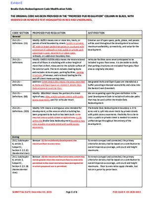
Brodie Oaks Redevelopment Code Modification Table THE ORIGINAL CODE HAS BEEN PROVIDED IN THE “PROPOSED PUD REGULATION” COLUMN IN BLACK, WITH MODIFIED OR REMOVED TEXT HIGHLIGHTED IN RED AND UNDERLINED. CODE SECTION General 25-1-21 – Definitions. (11) 25-1-21 – Definitions 25-1-21 – Definitions 25-1-21 – Definitions. (98) 25-1-21 – Definitions. (105) Zoning 25-2, Subchapter B, Article 2, Subpart C, Section 3.2.2. (C) (Residential Uses) 25-2, Subchapter B, Article 2, Subpart C, Section 3.2.3. (B) (Nonresidential Uses) PROPOSED PUD REGULATION JUSTIFICATION Modify: BLOCK means one or more lots, tracts, or parcels of land bounded by streets (public or private), 30’ wide or larger pedestrian paseo or courtyard with a minimum 5’ sidewalk or trail, public or private park space/open space, easement, or plaza space, railroads, or subdivision boundary lines. Modify: GROSS FLOOR AREA means the total enclosed area of all floors in a building with a clear height of more than six feet, measured to the outside surface of the exterior walls. The term includes loading docks and excludes atria airspace, parking facilities, parking structures, driveways, and enclosed loading berths and off-street maneuvering areas. Addition: OPEN SPACE (OS) means the areas identified as Parks and Open Space on Exhibit C: Brodie Oaks Redevelopment Land Use Plan. Modify: ROADWAY means the portion of a street right-of-way, alley, and/or private streets with public access easements used for vehicular travel. Modify: SITE means a contiguous area intended for development, or the area on which a building has been proposed to be built or has been built. A site may not cross a public street or right-of-way. A site within the Brodie Oaks Redevelopment boundary may cross a public or private street with public access easements. Remove: (C) for multifamily development, the maximum floor to area ratio; Remove: (B) the maximum floor area ratio, which may not be greater than the maximum floor to area ratio permitted in the most restrictive base zoning district in which proposed use is permitted; Creative use of open space, parks, plazas, and paseos will be used throughout the development to achieve maximum walkability, connectivity, and value for the development. Vehicular facilities were never anticipated to be included in gross floor areas. It is desirable to clarify that parking structures are excluded from gross floor area as originally intended. Designated Parks and Open Space are intended as a buffer providing enhanced accessibility and vistas into the Barton Creek Greenbelt. We are expanding upon the given definition in the Land Development Code to include all vehicular paths that may be used within the Brodie Oaks Redevelopment. The Brodie Oaks Redevelopment boundary is 37.6 acres and is split into seven tracts by private streets with public access easements. Flexibility for a site to cross a public or private street is needed to create a unified design throughout the entirety of the development. To remain compact and connected, the primary criteria for density shall be based on a contribution to overall impervious coverage, unit count and height maximums. To remain compact and connected, the primary criteria for density shall be based on a contribution to overall impervious coverage, unit count and height maximums. Floor to area ratios apply sitewide, but not on a parcel by parcel basis. SUBMITTAL DATE: December 03, 2020 Page 1 of 6 PUD CASE #: CD-2020-0002 Brodie Oaks Redevelopment Code Modification Table CODE SECTION PROPOSED PUD REGULATION Modify: (D) the minimum front yard and street side yard setbacks, shall be modified as stated in Exhibit C: Brodie Oaks Redevelopment Land Use Plan which must be not less than the greater of: 1. 25 feet for a front yard, and 15 feet for a street side yard; or 2. those required by Subchapter C, Article 10 (Compatibility Standards); Modify: (B). the developer either: 1. for developments with residential units, provides contract commitments and performance guarantees that provide affordable housing meeting or exceeding the requirements of Section 2.5.3 (Requirements for Rental Housing) and Section 2.5.4 (Requirements for Ownership Housing); or 2. for developments with no residential units, either provide contract commitments and performance guarantees that provide affordable housing meeting or exceeding the requirements of Section 2.5.3 ( Requirements for Rental Housing ) and Section 2.5.4 ( Requirements for Ownership Housing ) within the boundaries of the Brodie Oaks Redevelopment OR provides the amount established under Section 2.5.6 ( In Lieu Donation ) for each square foot of bonus square footage above the baseline to the Affordable Housing Trust Fund to be used for producing or financing affordable housing, as determined by the Director of the Neighborhood Housing and Community Development Department. Modify: (A) Exhibit C: Brodie Oaks Redevelopment Land Use Plan The table in Subsection (C) provides the permitted uses for the property. Addition: The permitted uses included in Exhibit C: Brodie Oaks Redevelopment Land Use Plan may be amended administratively in the future provided there is no increase in trips, number of units, or impervious cover. Modify: (A) The table in Subsection (C) provides the permitted and conditional uses for each base district. "P" means a use is a permitted use, "C" means a use is a conditional use, and "X" means a use is prohibited. Endnotes provide additional information. Exhibit C: Brodie Oaks Redevelopment Land Use Plan establishes the principle site development regulations. 25-2, Subchapter B, Article 2, Subpart B, Section 2.5.2.B – Requirements for Exceeding Baseline. 25-2-491 – Permitted, Conditional, And Prohibited Uses 25-2-491- Permitted, Conditional and Prohibited Uses 25-2-492 – Site Development Regulations JUSTIFICATION Building locations shall conform with an urban development located along a high capacity transit corridor. The exact size and density of the future development will be contingent on the market. The Brodie Oaks Redevelopment is committed to meeting affordability requirements for both residential and non-residential buildings and would like the option to meet affordability requirements in non-residential buildings within another building on the site. Brodie Oaks Redevelopment is planned to be more mixed-use than the base zoning district would allow. The Brodie Oaks Redevelopment is anticipated to be governed by this PUD into the foreseeable future, as new uses are added or amended the PUD should be able to accommodate those administratively. The Brodie Oaks Redevelopment is proposing denser and more compact uses along S. Lamar Boulevard and Loop 360 frontages to minimize impervious cover. To achieve this goal, it is necessary to have more flexibility in the minimum setbacks and development standards in the Brodie Oaks Redevelopment. SUBMITTAL DATE: December 03, 2020 Page 2 of 6 PUD CASE #: CD-2020-0002 Brodie Oaks Redevelopment Code Modification Table PROPOSED PUD REGULATION Addition: This Article does not apply to: (4) The Brodie Oaks Redevelopment PUD CODE SECTION 25-2-1052 Compatibility Standards – Exceptions; 25-2 - Subchapter E Sec 2.2.1 B 25-2 Subchapter E 2.2.2B 1 Planting Zone 25-2 Subchapter E 2.2.2B 2 Clear Zone 25-2 Subchapter E 2.2.2E Off Site Parking JUSTIFICATION The Barton Creek Greenbelt is currently zoned SF-2 instead of public. While the Brodie Oaks Redevelopment has included open space along most of the parkland boundary, compatibility standards may impact portions of the site designated for development. The proposed Land development Code revisions had dedicated the park as "Park". S. Lamar Boulevard is predominantly a TxDot ROW and functions more as an on-ramp for Loop 360 in this location. The character of this roadway in this location does not lend itself to the active, vibrant, and high-quality pedestrian environment that is desired by the Brodie Oaks Redevelopment. The Brodie Oaks Redevelopment is planning extensive improvements along South Lamar to include sidewalks a transit stop and street trees. The Brodie Oaks Redevelopment is including a double allee of trees and a cycle track within the street frontage. In addition, the project may need to alter the size of the planting strip in order to accommodate existing trees along the Internal Circulator Route. The Brodie Oaks Redevelopment is including a double allee of trees and a cycle track within the street frontage. In addition, the project may need to alter the size of the clear zone in order to accommodate existing trees along the Internal Circulator Route. Blocks adjacent to S. Lamar Boulevard are less than 250’ deep. The Internal Circulator Route is the priority street and structured parking adjacent to the Internal Circulator Route will be lined with active uses and plaza spaces. No surface parking will be located between the building and S. Lamar Boulevard. Modify: The roadway with the highest level of priority adjacent to the lot or site is considered the "principal street" for purposes of this Subchapter. For a lot or site that is adjacent to more than one roadway of equal priority, the development shall be subject to the standards associated with the roadway with the highest level of transit service that does not contain TxDOT ROW as determined by the Director. If the roadways do not have transit service or the level of transit service is equal, the roadway designated by the lot owner. The priority street for the Brodie Oaks Redevelopment is the Internal Circulator Route. For large sites subject to Section 2.2.5. or for sites abutting more than one roadway type, the Sidewalk and Supplemental Zone requirements (but not the Building Placement and Parking requirements) shall apply along all abutting streets or the Internal Circulation Route frontages, with the applicable requirements determined by the roadway type. Modify B1a. Planting Zone. The planting zone shall have a minimum width of eight six feet (from face of curb) and shall be continuous and located adjacent to the curb or cycle track provided that the sidewalk width is never less than 15’. Modify: B2. Clear Zone. The clear zone shall be a minimum width of seven six feet, shall be hardscaped, shall be located adjacent to the planting zone, and shall comply with ADA and Texas Accessibility Standards. The clear zone shall be unobstructed by any permanent or nonpermanent element for a minimum width of seven six feet and a minimum height of eight feet provided that the sidewalk width is never less than 15’. Modify: E1. Off-street surface parking is prohibited between the Core Transit Corridor and the corresponding street-facing facade line. Off-street structured parking is prohibited between the Internal Circulator Route and the corresponding street-facing facade line. SUBMITTAL DATE: December 03, 2020 Page 3 of 6 PUD CASE #: CD-2020-0002 Brodie Oaks Redevelopment Code Modification Table CODE SECTION 25-2 Subchapter E 2.2.5 C Block Standards PROPOSED PUD REGULATION Modify: C1. Unless exempted by this subsection, a site shall be divided into internal blocks, no larger than 5 acres. The perimeter of a block is defined by private streets with a public access easement, public streets, and public open spaces that include a pedestrian path. The maximum length of any block face, as measured from intersection to intersection, shall be 800 feet. 25-2 Subchapter E 2.2.5 G 25-2 Subchapter E 4.3.3 C 25-2-1104 – Hill Country Roadway Overlay Exceptions Modify: G.2 If the Internal Circulation Route is intended to accommodate bicycles, head-in and angle parking is not permitted except when the cycle tract is provided between the clear zone and the head-in or angle parking. Modify: C. Along at least 75 percent of the building frontage along the principal street, the building must be designed for commercial uses in ground-floor spaces that meet the following standards. A residential use or amenity space for residential uses may occupy a space that is designed for commercial uses. A lobby serving another use in the VMU building shall not count as a pedestrian-oriented commercial space for purposes of this section as long as it is designed to meet the standards of this section. a. A customer entrance that opens directly onto the sidewalk; b. A depth of not less than 24 feet; c. A height of not less than 12 feet, measured from the finished floor to the bottom of the structural members of the ceiling; and d. A front facade that meets the glazing requirements of Section 3.2.2. Addition: (F) This article does not apply to development within Area’s 1 or 2 of Exhibit C: Brodie Oaks Redevelopment Land Use Plan. Subdivision 25-4-171 – Access to Lots Modify: (A) Each lot in a subdivision shall abut a dedicated public street, or private street with public access easement. JUSTIFICATION The Brodie Oaks Redevelopment PUD is limited in the number of vehicular access points to TxDOT frontage roads. The project is also situated adjacent to the Barton Creek Greenbelt for a majority of the northwestern boundary line reducing the ability to make vehicular connections. The project is improving both pedestrian and bicycle access within and through the site. The Brodie Oaks Redevelopment is including cycle tracts along the Internal Circulator Route. Refer to Exhibit E: Brodie Oaks Redevelopment Street Cross Sections. The Brodie Oaks Redevelopment is focusing active ground floor uses around the internal green space and central buildings along the Internal Circulator Route. Other ground floor spaces will be designed so that they can accommodate additional commercial in the future based on demand. The Hill Country Roadway Ordinance is not compatible with the Imagine Austin Comprehensive Plan designation of the site as a Center for Redevelopment in Environmentally Sensitive Areas. The site is currently developed and does not contribute to the Hill Country aesthetic that is being preserved through the ordinance. The Brodie Oaks Redevelopment will establish a more appropriate transition from the Imagine Austin Comprehensive Plan High Capacity Transit Corridor on S. Lamar Boulevard to the Hill Country along Loop 360. Private streets with public access easements will serve the Brodie Oaks Redevelopment. SUBMITTAL DATE: December 03, 2020 Page 4 of 6 PUD CASE #: CD-2020-0002 Brodie Oaks Redevelopment Code Modification Table CODE SECTION Transportation 25-6-171 – Standards for Design and Construction. Section 25-6-477, 25-6-478, 25-6- 532 and Appendix A – Off-Street Parking and Loading TCM 1.3.1 General Design Criteria Environmental 25-8-25(C) PROPOSED PUD REGULATION Modify: (A) Except as provided in Subsections (B) and (C), a roadway, street, or alley must be designed and constructed in accordance with the Transportation Criteria Manual and City of Austin Standards and Standard Specifications and Exhibit E: Brodie Oaks Redevelopment Street Cross Sections. JUSTIFICATION To provide a compact and connected community, we would like to provide alternative street sections that allow for additional pedestrian and bike connections and more landscaping. Addition: The minimum off-street parking, bicycle parking, and loading requirements shall be determined by the director subject to a Transportation Demand Management Plan approved as part of the PUD. The Brodie Oaks Redevelopment intends to provide a mixed use development with a robust travel demand management plan to better utilize shared parking opportunities within the site and to surrounding multi- modal connections. Addition: Allow the construction of the Bicycle Friendly Connector between the Brodie Oaks Redevelopment site and Barton Creek Plaza as indicated in Exhibit E: Brodie Oaks Redevelopment Street Cross Sections. The Brodie Oaks Redevelopment is proposing to improve the street between the project and Barton Creek Plaza with a Shared Use Path. This street exists within a 40’ easement and the multi-use trail would be provided on the park side of the easement. Modify (C)(1): The requirements of this subchapter do not apply to the redevelopment of the property if the redevelopment: (1) Includes an impervious cover tracking chart that guarantees a decrease in impervious cover with each phase of development such that impervious cover in the final phase of development is 54 percent or less of the total site area. The Brodie Oaks Redevelopment intends to build out in phases in accordance with Exhibit H: Brodie Oaks Redevelopment Phasing Plan 25-8-26 – Redevelopment Exception in the Barton Springs Zone Modify: (F) City Council approval of a redevelopment in accordance with Subsection (G) is not required if the redevelopment is located within the Brodie Oaks Redevelopment. The Brodie Oaks Redevelopment is fully complying with the Save Our Springs (SOS) Ordinance water quality mitigation requirements and is not utilizing any sedimentation/ filtration ponds. Remove: (H) Redevelopment of property under this section requires the purchase or restriction of mitigation land if the site has a sedimentation/filtration pond. 25-8-341 – Cut Requirements Modify: Cuts on a tract of land may not exceed four feet depth except where indicated in Exhibit G: Brodie Oaks Redevelopment Grading Plan 25-8-342 – Fill Requirements Modify: Fill on a tract of land may not exceed four feet depth except where indicated in Exhibit G: Brodie Oaks Redevelopment Grading Plan The Brodie Oaks Redevelopment is proposing to restore the site back to original pre-development grades and cuts exceeding 4’ will be necessary to achieve restoration. The Brodie Oaks Redevelopment is proposing to restore the site back to original pre-development grades and fill exceeding 4’ will be necessary to achieve restoration. 25-8-641 – Removal Prohibited Modify: (B) A permit to remove a heritage tree may be issued only if a variance is approved under Section 25- 8-642 (Administrative Variance) as amended in this PUD or 25-8-643 (Land Use Commission Variance). A limited number of Heritage trees will need to be relocated on site to accommodate the restoration of the site to natural grades or to accommodate the compact nature of the redevelopment. SUBMITTAL DATE: December 03, 2020 Page 5 of 6 PUD CASE #: CD-2020-0002 Brodie Oaks Redevelopment Code Modification Table CODE SECTION 25-8-642 – Administrative Variance ECM 1.5.3 (B) Open Space ECM 1.8.1 – 25-8-63 (C) – Impervious Cover Calculations Site Plans Sec. 25-5-81(B) PROPOSED PUD REGULATION Addition: (A)(4) if required to restore the site to natural grade or accommodate the compact nature of the redevelopment transplanting a heritage tree may be approved administratively. Transplanting a heritage tree is not considered removal if the criteria in ECM Section 3.5.4.E are met. Modify: Open space includes the following uses: Public or Private Park. Park facilities may include water quality ponds, picnic areas, bathrooms, shade pavilions, play grounds, stages, interpretive centers, public art, bird viewing blinds, trails, trail and pedestrian amenities, interpretive signs, seating, mowed meadow, informal lawn space and other applicable items determined at the time of site plan uses like picnic facilities, benches, community gardens, and other recreational amenities and appurtenances. Modify: Impervious cover calculations exclude: • sidewalks in a public right-of-way or public access easement or publicly accessible open space containing a public recreation easement; • multi-use trails open to the public and located on public land or in a public access easement or publicly accessible open space containing a public recreation easement; Modify: Except as provided in Subsections (C), (D), and (E) of this section, a site plan expires three eight years after the date of its approval. JUSTIFICATION A limited number of Heritage trees will need to be relocated on site to accommodate the restoration of the site to natural grades or to accommodate the compact nature of the redevelopment. The Brodie Oaks Redevelopment anticipates a system of highly amenitized and activated parks and open spaces including an intentional trailhead to the Barton Creek Greenbelt and areas for public viewing and vistas. The Brodie Oaks Redevelopment is proposing superior amenities and multi-modal transportation routes within the publicly accessible open space and private streets with public access easements. The project seeks to clarify that impervious cover for sidewalks and multi modal paths does not apply within these areas. The Brodie Oaks Redevelopment is intended to be phased over a number a years. SUBMITTAL DATE: December 03, 2020 Page 6 of 6 PUD CASE #: CD-2020-0002 Bike-Friendly Collector BARTON CREEK GREENBELT L O O P 3 6 0 Internal Circulator Route - Residential Internal Circulator Route - Commercial SITE METRICS Total Site Area Minimum Lot Size Minimum Lot Width Maximum Impervious Cover* Maximum Building Coverage* Maximum Floor Area Ratio* Minimum Setbacks Front Street Side Yard Interior Side Yard Rear Yard LAND USE AREA METRICS Land Use Area 1A 15.3 275’ Acreage Maximum Height 37.6 Acres / 1,637,856 Sq. ft. 5,750 square feet 50 feet 54% 40% 1.9 : 1 0 feet 0 feet 0 feet 0 feet Land Use Area 1B 8.6 160’ Land Use Area 2 13.7 28’ *Maximum Impervious Cover, Building Coverage, and Floor-To-Area is based on Gross Site Area of all of the land within the PUD and will be higher on a parcel by parcel basis. Land Use Area 1A Land Use Area 1B Land Use Area 2 Private Streets with Public Access Easements P O O S S T R U T E A L M PI D B A PIT O R R A T C E M D R A V E L U O R B A M A S . L 0 100 200 400 EXHIBIT C: BRODIE OAKS REDEVELOPMENT LAND USE PLAN (PAGE1) SUBMITTAL DATE: DECEMBER 08, 2020 PUD CASE #: CD-2020-0002-BRODIE OAKS REDEVELOPMENT Land Use Plan Notes • Medical Office – not exceeding 5,000 sq. ft. gross 1. The maximum FAR of Area 2 shall not exceed .3. 2. Chapter 25-2 Article 11 Hill Country Roadway Requirements shall not apply to this property. 3. The following uses are permitted uses within Land Use Areas 1A and 1B. Residential Uses • Bed & Breakfast (Group 1) • Bed & Breakfast (Group 2) • Condominium Residential • Group Residential • Multifamily Residential • Townhouse Residential • Short-Term Rental (Types 1 and 3) Commercial Uses • Administrative and Business Office • Art Gallery • Art Work Shop • Automotive Sales • Automotive Rentals • Automotive Repair Services • Business or Trade School • Business Support Services • Cocktail Lounge • Commercial Off-Street Parking • Communications Services • Consumer Convenience Services • Consumer Repair Services • Convenience Storage • Electronic Prototype Assembly • Electronic Testing • Financial Services • Food Preparation • Food Sales • General Retail Sales (Convenience) • General Retail Sales (General) • Hotel-Motel • • • Kennels • Laundry Services • Liquor Sales • Medical Offices – exceeding 5,000 sq. ft. gross Indoor Entertainment Indoor Sports and Recreation floor area floor area • Off-Site Accessory Parking • Outdoor Entertainment • Outdoor Sports and Recreation • Pedicab Storage and Dispatch • Personal Improvements Services • Personal Services • Pet Services • Plant Nursery • Printing and Publishing • Professional Office • Recreational Equipment Maint. & Stor. • Recreational Equipment Sales • Research Assembly Services • Research Services • Restaurant (General) • Restaurant (Limited) • Service Station • Software Development • Theater • Vehicle Storage • Veterinary Services Industrial Uses • Custom Manufacturing • General Warehousing and Distribution • Light Manufacturing • Limited Warehousing and Distribution Agricultural Uses • Community Garden • • Urban Farm Civic Uses • Administrative Services • Camp • Club or Lodge • College and University Facilities • Communication Service Facilities • Community Events • Community Recreation (Private) • Community Recreation (Public) • Congregate Living • Convalescent Services • Counseling Services • Cultural Services • Day Care Services (Commercial) • Day Care Services (General) • Day Care Services (Limited) • Family Home Indoor Crop Production 4. The following uses are permitted uses within Land Use Area 2. • Hospital Services (General) • Hospital Services (Limited) • Maintenance and Service Facilities • Park and Recreation Services (General) • Park and Recreation Services (Special) • Private Primary Educational Facilities • Private Secondary Educational Facilities • Public Primary Educational Facilities • Public Secondary Educational Facilities • Religious Assembly • Safety Services • Telecommunication Tower Commercial Uses • Art Gallery • Commercial Off-Street Parking • Food Preparation • Food Sales • General Retail Sales (Convenience) • General Retail Sales (General) • Outdoor Entertainment • Outdoor Sports and Recreation • Pedicab Storage and Dispatch • Recreational Equipment Maint. & Stor. • Restaurant (General) • Restaurant (Limited) Agricultural Uses • Community Garden Civic Uses • Administrative Services • Camp • Club or Lodge • Community Events • Community Recreation (Private) • Community Recreation (Public) • Cultural Services • Day Care Services (Commercial) • Day Care Services (General) • Day Care Services (Limited) • Park and Recreation Services (General) • Park and Recreation Services (Special) • Private Primary Educational Facilities • Private Secondary Educational Facilities • Public Primary Educational Facilities • Public Secondary Educational Facilities • Religious Assembly 5. Parkland dedication shall be satisfied in accordance with Exhibit D: Brodie Oaks Redevelopment Parks and Open Space Plan. 6. A site can cross a public or private street or right-of- way. 7. A site plan for the construction of an amphitheater, pavilion or other outdoor venue located in Land Use Area 2 that is associated with a commercial, civic, or residential use may be approved administratively. 8. Within Land Use Area 2 and the Internal Circulator Route, sidewalks, multi-use trails, water quality controls, detention basins, drainage swales, ponds, areas with gravel, weed screens, solar screen tents, porous pavement, fire lanes with interlocking pavers, and subsurface parking structures, shall be credited as 100 percent pervious cover in accordance with Section 25-8-63 (C) and Section 1.8.1 of the City of Austin Environmental Criteria Manual. EXHIBIT C: BRODIE OAKS REDEVELOPMENT LAND USE PLAN (PAGE 2) SUBMITTAL DATE: DECEMBER 08, 2020 PUD CASE #: CD-2020-0002-BRODIE OAKS REDEVELOPMENT Name Overlook Trailhead Central Green Neighborhood Park Total % of Site (37.6 acres) Acres Open Space Restored Landscape Publicly Accessible Yes Yes 6.7 2.7 1.8 2.5 Yes Yes Yes Yes Yes Yes Yes Yes Private Parkland Credited Acres* 6.1 acres 2.4 acres 13.7 13.7 36.4% 36.4% 25.0% 9.4 13.7 36.4% 8.4 22.3% *See Private Parkland Credit Calculation Table Overlook SOS Pond (0.24 acres) BARTON CREEK GREENBELT SOS Ponds (0.22 acres) Trailhead L O O P 3 6 0 Central Green Open Space SOS Ponds Private Streets with Public Access Easements Neighborhood Park O U S S T O P E T R A PIT A L M R A PID B C E T R O M D R A V E L U O R B A M A S . L 0 100 200 400 EXHIBIT D: BRODIE OAKS REDEVELOPMENT PARKS AND OPEN SPACE (PAGE 1) SUBMITTAL DATE: DECEMBER 08, 2020 PUD CASE #: CD-2020-0002-BRODIE OAKS REDEVELOPMENT Parks and Open Space Notes recreation purposes in perpetuity. The parkland dedication required to meet the parkland dedication ordinance requirements for the Brodie Oaks Redevelopment is 31 acres. • • • • • • • OPEN SPACE The open space required to meet the PUD Tier I (Sec.2.3.1c) “superior development” standard is 10 percent of the residential tracts and 20 percent of non-residential tracts. The Brodie Oaks Redevelopment is a mixed use development consisting of both residential and non-residential uses and uses the commercial designation. Mixed Use developments are classified as non-residential and use the 20 percent: • Area within Land Use Area 1A and 1B: 23.9 acres • Open space required: 4.8 acres (20 percent of 23.9 acres) • Total open space provided: 13.7 acres (57.3 percent of 23.9 acres) The open space required to meet the requirements in PUD Tier II (Sec.2.4) is open space at least 10 percent above the requirements of Section 2.3.1.A. (Minimum Requirements). Alternatively, within the urban roadway boundary established in Figure 2 of Subchapter E of Chapter 25-2 (Design Standards and Mixed Use), provide for proportional enhancements to existing or planned trails, parks, or other recreational common open space in consultation with the Director of the Parks and Recreation Department. • Area within Land Use Areas 1A and 1B: 23.9 acres • Open space required to meet Tier II: 7.2 acres (30 percent of 23.9 acres) • Total open space required: 13.7 acres PARKLAND The Brodie Oaks Redevelopment is located in the Parkland Dedication Urban Core where a max of 15 percent of the gross site area is required to be dedicated on site for a typical development. The original Brodie Oaks PUD dedicated 84.3 acres of parkland in 1981 making up a substantial part of Gus Fruh Park within the Barton Creek Greenbelt. This original parkland dedication represents nearly twice the amount of parkland required by this development and the previous development at today’s standards. According to the parkland dedication operating procedures (Sec.14.3.9B) to be considered “superior development,” land proposed for dedication must: 1. Include at least 10.4 credited acres per 1,000 residents, 2. Be developed in accordance with a plan approved by PARD; and 3. Be dedicated to a governmental entity. The Brodie Oaks Redevelopment is proposing to dedicate an easement allowing the public to access and use the land for Total Parkland Required: 31 acres Total Required on site: 5.6 acres (15 percent of 37.6 acres) Total Provided: 8.5 acres (See Private Parkland Credit Calculations) PRIVATE PARKLAND CREDIT CALCULATIONS Total Acreage Acreage of Ponds 6.7 2.7 Total Unencumbered Acres 6.7 2.5 Total Acreage Credited 90%* 8.3 8.4 0 .2 50% .1 Overlook Trailhead Percent Credited Total Acreage Credited * Sec.14.3.10 of the parkland development operating procedures includes evaluation criteria for calculating private parkland dedication. 90 percent credit for Brodie Oaks Redevelopment has been applied in accordance with the following criteria: • • • • Brodie Oaks Redevelopment is not claiming credit for the following criteria: • (40 percent) - Active recreation amenities (30 percent) - Public access in perpetuity (10 percent) - Group gathering places (10 percent) - Landscaping (10 percent) - Ability for PARD to provide programming PARKLAND DEVELOPMENT The Brodie Oaks Redevelopment will develop, operate, and maintain all open space on site. The Brodie Oaks Redevelopment is committing to exceed the 2021 Parkland Development Fee by $100 for both residential and hotel units. Existing 2021 Parkland Development Fees - Residential: $492.88 / unit Existing 2021 Parkland Development Fees - Hotel: $354.87 / room Proposed Parkland Development Fees - Residential: $592.88 / unit Proposed Parkland Development Fees - Hotel: $454.87 / room RESTORED LANDSCAPE The Brodie Oaks Redevelopment is committing to the restoration of 9.4 acres of open space located in Overlook and Trailhead open spaces. The restoration of these areas will include removal of the existing surface parking and wall and returning the area back to natural grades and revegetating with native and adaptive plants. This work will require cuts that exceed 4’. EXHIBIT D: BRODIE OAKS REDEVELOPMENT PARKS AND OPEN SPACE (PAGE 2) SUBMITTAL DATE: DECEMBER 08, 2020 PUD CASE #: CD-2020-0002-BRODIE OAKS REDEVELOPMENT BARTON CREEK GREENBELT L O O P 3 6 0 Internal Circulator Route - Residential Internal Circulator Route - Commercial P O O S S T U R T E A L M PI D B A R PIT O R A T C E M D R A V E L U O R B A M A S . L 0 100 200 400 EXHIBIT E: BRODIE OAKS REDEVELOPMENT STREET CROSS SECTIONS (PAGE 1) SUBMITTAL DATE: DECEMBER 08, 2020 PUD CASE #: CD-2020-0002-BRODIE OAKS REDEVELOPMENT Bike-Friendly Collector BARTON CREEK GREENBELT L O O P 3 6 0 P O O S S T U R T E A L M PI D B A R PIT O R A T C E M D R A V E L U O R B A M A S . L 0 100 200 400 EXHIBIT E: BRODIE OAKS REDEVELOPMENT STREET CROSS SECTIONS (PAGE 2) SUBMITTAL DATE: DECEMBER 08, 2020 PUD CASE #: CD-2020-0002-BRODIE OAKS REDEVELOPMENT Water Quality and Drainage Notes 1. Water quality volume and re-irrigation areas will comply with the Save Our Springs (SOS) Ordinance. 2. Re-Irrigation within Barton Springs Greenbelt is allowed by the Recorded Covenants Doc. #7649- 274. WATER QUALITY AND DRAINAGE METRICS SOS Required Irrigation Area Existing Impervious Cover Maximum Proposed Impervious Cover* 54% Total Site Area 10 Ac. 83.7% 37.6 Ac. *Multi-Use Trails, Sidewalks, Planter Strips and Other Park and Landscape Improvements shall be credited as pervious cover. Irrigation Flows Storm Sewer Flows Irrigation Areas SOS Ponds Private Streets with Public Access Easements 7 0 9 695 696 697 698 700 701 7 0 2 7 0 3 7 0 4 7 0 5 7 0 7 710 1 1 7 L O O P 3 6 0 BARTON CREEK GREENBELT 714 713 711 7 1 2 7 1 3 706 707 708 709 705 706 707 708 709 7 1 1 7 0 9 710 7 0 8 7 0 9 7 0 7 710 711 7 1 1 7 1 0 709 708 710 7 0 9 705 708 706 707 704 703 697 699 700 698 696 702 701 6 9 5 4 9 6 6 9 6 7 9 6 6 9 9 6 9 8 6 9 5 6 9 4 6 9 3 6 9 3 6 9 2 693 700 6 9 2 711 710 709 711 709 710 7 0 8 708 707 706 708 705 701 700 U O R B A 6 9 5 M A S . L 7 3 0 0 7 2 7 1 0 0 0 7 E L D R A V 8 0 7 707 709 706 7 0 5 7 0 9 0 1 7 1 1 7 0 1 7 9 0 7 7 0 8 702 701 703 7 0 4 6 9 8 9 9 6 0 0 7 O U S S T O P 708 707 7 0 6 7 0 3 5 0 7 7 0 4 706 707 705 E T R A PIT A L M R A PID B C E T R O 5 0 7 M 0 200 400 800 EXHIBIT F: BRODIE OAKS REDEVELOPMENT WATER QUALITY AND DRAINAGE SUBMITTAL DATE: DECEMBER 08, 2020 PUD CASE #: CD-2020-0002-BRODIE OAKS REDEVELOPMENT