05 C814-2018-0122.03 - Circuit of the Americas Planned Unit Development Amendment #3; District 2 - Staff Report Part 1 — original pdf
Backup
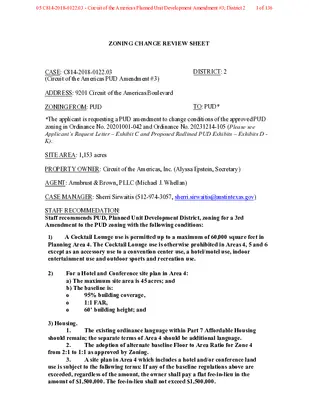
ZONING CHANGE REVIEW SHEET CASE: C814-2018-0122.03 (Circuit of the Americas PUD Amendment #3) DISTRICT: 2 ADDRESS: 9201 Circuit of the Americas Boulevard ZONING FROM: PUD TO: PUD* *The applicant is requesting a PUD amendment to change conditions of the approved PUD zoning in Ordinance No. 20201001-042 and Ordinance No. 20231214-105 (Please see Applicant’s Request Letter – Exhibit C and Proposed Redlined PUD Exhibits – Exhibits D - K). SITE AREA: 1,153 acres PROPERTY OWNER: Circuit of the Americas, Inc. (Alyssa Epstein, Secretary) AGENT: Armbrust & Brown, PLLC (Michael J. Whellan) CASE MANAGER: Sherri Sirwaitis (512-974-3057, sherri.sirwaitis@austintexas.gov) STAFF RECOMMEDATION: Staff recommends PUD, Planned Unit Development District, zoning for a 3rd Amendment to the PUD zoning with the following conditions: A Cocktail Lounge use is permitted up to a maximum of 60,000 square feet in 1) Planning Area 4. The Cocktail Lounge use is otherwise prohibited in Areas 4, 5 and 6 except as an accessory use to a convention center use, a hotel/motel use, indoor entertainment use and outdoor sports and recreation use. 2) For a Hotel and Conference site plan in Area 4: a) The maximum site area is 45 acres; and b) The baseline is: o o o 95% building coverage, 1:1 FAR, 60’ building height; and 3) Housing. 1. The existing ordinance language within Part 7 Affordable Housing should remain; the separate terms of Area 4 should be additional language. 2. The adoption of alternate baseline Floor to Area Ratio for Zone 4 from 2:1 to 1:1 as approved by Zoning. 3. A site plan in Area 4 which includes a hotel and/or conference land use is subject to the following terms: If any of the baseline regulations above are exceeded, regardless of the amount, the owner shall pay a flat fee-in-lieu in the amount of $1,500,000. The fee-in-lieu shall not exceed $1,500,000. CITY COUNCIL ACTION: April 23, 2026 ORDINANCE NUMBER: 05 C814-2018-0122.03 - Circuit of the Americas Planned Unit Development Amendment #3; District 21 of 136 3) The Landowner has dedicated a 20-foot trail and recreation easement recorded in Document No. 2023026306 of the Travis County Real Property Records. The COTA PUD shall provide for an Urban Trails Master Plan Tier II trail in the outer half of the Critical Water Quality Zone and located outside of the erosion hazard zone. The Director of Transportation Public Works shall have discretion to amend, relocate, or terminate this easement and trail requirements. 4) Parks approves the location of the parkland as “superior” because it is more developable land (8.03 acres as shown on the original PUD Land Use Plan versus 11.8 acres on the amended proposal) and better located with the following conditions: 1. Owner will ensure that all aspects of the soccer fields (parking lot, permanent goals posts, irrigation, signage, etc.) can be constructed on the site. 2. Owner will be responsible for providing water for irrigation to the soccer field site. 3. If the easement owners in the soccer field area need to damage the fields to make repairs within the easements, the park improvements would be repaired by the COTA PUD Owner. 4. If all aspects of the soccer fields (parking lot, permanent goals posts, irrigation, signage, etc.) cannot be constructed on the designated soccer site because of the existing easements, the COTA PUD Owner will provide an alternative soccer field site that is acceptable to the Parks Director and that will be developed by the COTA PUD Owner in the same manner as set forth in the Amended PUD. 5) Drainage. Sections 25-7-93 (General Exceptions) and 25-7-96 (Requirements in the 25-Year Floodplain) are modified to apply to the following proposed buildings/structures: no more than three (3) restroom facilities not to exceed 2,000 sq. ft. each, and no more than two (2) maintenance and/or storage facilities not to exceed 22,000 sq. ft. total. Development allowed under this subsection must be unoccupied structures that only contain non-habitable, nonconditioned space and: 1. be no lower than three feet above the 100-year floodplain, as measured from the lowest floor elevation of any proposed building; 2. Be designed on a pier and beam foundation with the volume under the building available for floodplain storage; 3. comply with the requirements in Chapter 25-12, Article 3 (Flood Hazard Areas); 4. will not be required to provide normal access to a proposed building/structure by direct connection with an area above the regulatory flood datum, as prescribed by Chapter 25-12, Article 3 (Flood Hazard Areas); 5. compensate for the floodplain volume displaced by the development; and 6. result in no additional adverse flooding impact on other properties, as determined by the director. 05 C814-2018-0122.03 - Circuit of the Americas Planned Unit Development Amendment #3; District 22 of 136 C814-2018-0122.03 PARKS AND RECREATION BOARD: February 23, 2026: Recommend that City Council not approve PUD Amendment (Vote: 8-1, Pedro Villalobos-no); Ted Eubanks-1st, Diane Kearns-Osterweil-2nd. Please see Parks and Recreation Board Motion Sheet - Exhibit L. ENVIRONMENTAL COMMISSION: March 4, 2026: Recommended approval with conditions (Vote: 6-1, Krueger-no); Qureshi-1st, Brimer-2nd. Please see Environmental Commission Motion Sheet - Exhibit M. ZONING AND PLATTING COMMISSION: April 7, 2026 CITY COUNCIL ACTION: April 23, 2026 CASE MANAGER COMMENTS: The Circuit of the Americas Planned Unit Development is a 1,153 acre property generally located east of State Highway 130 and north of FM 812 on Circuit of the Americas Boulevard. The PUD consists of a mixed-use development and is currently comprised of eight planning Areas with approximately 967 acres of commercial space (Areas 1, 3, 4, 5, 6, 7, & 8) and 186 acres of mixed use (Area 2). The land use plan includes 298 acres of open space that is dispersed throughout Areas 3, 4, 5, 6 and 8 on the site. The CS, General Commercial Services District, is the baseline zoning district for the PUD. The property in question was annexed in 2012 through Ordinance No. 20121108-027. The site is surrounded by residential and commercial properties within the City’s Extraterritorial Jurisdiction (ETJ) that do not have zoning and are not part of an active or near-future neighborhood planning effort. Although there are residential uses adjacent to the project, the majority of the properties are not located within the City of Austin and are not subject to compatibility requirements. The property is not located within an adopted neighborhood planning area. Therefore, an accompanying NPA is not required. COTA is an existing entertainment facility that is located within a “Job Center” as designated in the Imagine Austin Comprehensive Plan. In this rezoning application, the applicant is requesting an amendment to the PUD land use plan and zoning ordinance (please see redlined PUD Land Use Plan - Exhibit D, redlined Zoning Use Summary Table – Exhibit E and redlined PUD Ordinance No. 20201001-042 – Exhibit F) for the following: a. b. c. d. e. f. g. h. i. to remove square footage restrictions on cocktail lounge and liquor sales uses within Area 4 of the PUD to permit these uses over this 258-acre parcel, to change the Affordable Housing requirements to change bonus area calculations for a hotel/ motel use, to change Blackland Prairie Restoration requirements, for the reduction in the required open space by 78 acres (from 298 acres to 2020 acres), to allow for amusement parks, a golf course, cart paths, driving range, and related facilities to be permitted within the designated open space areas, to change the requirements for COTA to dedicate 11.38 acres of parkland to the city to allow a provision for parkland to be located within a two-mile radius of the PUD or for the applicant to have a fee in lieu option equal to the values of the parkland to be expended on parkland acquisition or improvements, to remove the requirement to construct two community soccer fields that are open to the public, to remove the requirement to provide a 30-foot easement for public access to parkland, to change the conditions of site plan approval for the applicant to propose on-site mitigation of CEFs on a 1:1 basis for staff consideration, 05 C814-2018-0122.03 - Circuit of the Americas Planned Unit Development Amendment #3; District 23 of 136 j. k. l. to add a note on the land use plan that states that, “Corrections shall be allowed for Site Plans even if the posted fiscal security has been returned.” to reduce bicycle parking requirements to two bicycle parking spaces for Commercial uses, five bicycle parking spaces for Multifamily Residential uses and one bicycle parking space for Civic uses, to allow for the construction of a golf course and related facilities including fairways, tees, greens, bunkers, hard surface cart paths, pedestrian bridges, elevated boardwalks, structural support piers, decks, irrigation, drainage, erosion control, and water quality facilities and one bridged crossing associated with a racetrack of in Planning Area 8 within the critical water quality zone, m. to reduce the critical water quality buffer zone to 75 feet from the edge of the critical n. o. p. q. r. s. t. u. v. w. x. environmental feature to allow for buffer averaging, to allow for irrigated and manicured vegetation within the CWQ buffer zone for artificially created critical environmental features, including a water hazard for a golf course. to allow a trail or golf cart path made of decomposed granite or compacted aggregate to cross the buffer zone. to allow construction of racetrack circulation routes exceeding 15 percent slope gradient in Planning Area 8, to allow for cut and fill exceeding four feet, but not exceeding 20 feet, throughout the PUD. to allow the director to grant an administrative variance from a requirement for a cut or fill of not more than thirty feet. to modify General On-Premise Signs to allow the following signs in Planning Area 4: one illuminated wall sign not exceeding 1,700 square feet; i. ii. one illuminated wall sign not exceeding 1,200 square feet; two illuminated wall signs not exceeding 600 square feet; iii. iv. four illuminated monument signs not exceeding 160 square feet; v. to modify Commercial Sign District Regulations to allow freestanding and wall signs not to exceed 200 square feet, to modify Sections 25-7-93 (General Exceptions) and 25-7-96 (Requirements in the 25-Year Floodplain) to allow maintenance facilities, trails, golf cart paths, elevated boardwalks, decks, structural support piers, pedestrian bridges, and a driving range associated with a golf course. to add a new parcel/area, Area 9 – Commercial, on the land use plan known as the Car Club District, to permit Condominium Residential, Mobile Home Residential, Multifamily Residential, Retirement Housing (Small and Large Site), Single-Family Residential, Townhouse Residential, Two-Family Residential and Short-Term Rental uses in Area 8 – Commercial (Commercial-Parkland District), to permit the Construction Sales and Services use in Area 1 – Commercial (Amusement District), Area 2 – Mixed Use (Hospitality + Car Enthusiast District), twelve wall signs not exceeding 40 square feet. 05 C814-2018-0122.03 - Circuit of the Americas Planned Unit Development Amendment #3; District 24 of 136 Area 3 – Commercial (Business + Car Club District), Area 4 – Commercial (Resort + Sports District) and Area 5 (Resort + Sports District), to permit the Carriage Stable use in Area 1 – Commercial (Amusement District), to permit the Building Maintenance Services use in the Area 7 – Commercial (COTA + Track District) y. z. aa. to permit the Equipment Repair Services use in the Area 1 – Commercial (Amusement District), Area 2 – Mixed Use (Hospitality + Car Enthusiast District), Area 3 – Commercial (Business + Car Club District), Area 4 – Commercial (Resort + Sports District) and Area 5 (Resort + Sports District), bb. to permit the Kennels use in Area 2 – Mixed Use (Hospitality + Car Enthusiast District), Area 5 (Resort + Sports District) and Area 7 – Commercial (COTA + Track District) cc. to permit the Recreation Equipment Sales use in the Area 1 – Commercial (Amusement District), Area 2 – Mixed Use (Hospitality + Car Enthusiast District), Area 3 – Commercial (Business + Car Club District), Area 4 – Commercial (Resort + Sports District) and Area 5 (Resort + Sports District), dd. to permit the Aviation Facilities use in the Area 4 – Commercial (Resort + Sports District), ee. to remove parking requirements in the PUD by adding a note to the Parking Table requirements on sheet 2 of the Land Use Plan to state, “This column is maintained and shown for purposed of calculating accessible spaces and for future reference as needed. No minimum or maximum number of parking spaces is required for any use within the PUD.” ff. to change the maximum height permitted on Areas 1, 2, 3, 5, 7 and 8 from 60 feet to 90 feet. gg. to change the maximum height permitted on Area 2 from 90 feet to 150 feet. hh. To change the maximum height permitted on Area 4 from 160 feet to 250 feet. ii. To alter the language listed on Page 2 of the land use plan from Amendment #1 that states that, “Maximum Height of 260 feet allowed for amusement park rides in Outdoor Entertainment Use Area for Area 5 and Area 6 to state, “Maximum height of 260 feet allowed for Amusement Park Rides.” for Areas 4, 5, 6 and 7. BASIS OF RECOMMENDATION: 1. The proposed zoning should be consistent with the purpose statement of the district sought. The Planned Unit Development (PUD) zoning district is intended for large or complex developments under unified control, planned as a single contiguous project. The PUD is intended to allow single or multi-use projects within its boundaries and provides greater design flexibility for development proposed within the PUD. Use of the PUD district should result in development superior to that which would occur using conventional zoning and subdivision regulations. PUD zoning is appropriate if the development enhances preservation of the natural environment; encourages high quality development and innovative design; and ensures adequate public facilities and services for development within the PUD. 05 C814-2018-0122.03 - Circuit of the Americas Planned Unit Development Amendment #3; District 25 of 136 2. Zoning should allow for reasonable use of the property. The proposed PUD amendment will enable the applicant to expand the existing Outdoor Entertainment (Circuit Race Track, Grand Plaza, Car Community, Germania Insurance Amphitheater, Speed City, COTALand amusement park) and Campground (COTA RV Park) uses on the property to include a destination 1,000 room hotel conference resort with a 460,000-square-foot convention center in Planning Area 4, an associated Outdoor Sports and Recreation use/golf course in Planning Areas 4, 5 and 6 and a practice race track on Planning Area 8. 3. Use of a PUD District should result in development superior to that which would occur using conventional zoning and subdivision regulations. The Circuit of the Americas PUD will provide options to maintain a superior development than that which could have occurred using conventional zoning and subdivision regulations. COTA is an established entertainment facility that is located within a designated “Job Center” on the Growth Concept Map in the Imagine Austin Comprehensive Plan. EXISTING ZONING AND LAND USES: Site I-RR ZONING North County South County East County West SF-4A, P LAND USES Outdoor Entertainment (Circuit of the Americas Racetrack, Austin360 Outdoor Amphitheater), Undeveloped Land Residential, Undeveloped Tracts, Aviation Facilities (Austin-Bergstrom Airport) Religious Assembly, Library, Service Station, Food Sales, Retail Services, Restaurant, RV Park, Residential, Undeveloped Single Family Residential, RV Park, Undeveloped Land Single Family Residential, Commercial NEIGHBORHOOD PLANNING AREA: N/A WATERSHED: Dry Creek and Maha Watersheds SCHOOLS: Del Valle Independent School District Popham Elementary School Del Valle Middle School Del Valle High School NEIGHBORHOOD ORGANIZATIONS: Austin Lost and Found Pets Del Valle Community Coalition 05 C814-2018-0122.03 - Circuit of the Americas Planned Unit Development Amendment #3; District 26 of 136 Del Valle Independent School District Elroy Neighborhood Association Friends of Austin Neighborhoods Neighborhood Empowerment Foundation Onion Creek Homeowners Assoc. Sierra Club, Austin Regional Group RELATED CASES: Previous Rezoning Cases: C814-2018-0122, C814-2018-0122.01, C814-2018-0122.02 Site Plan Case: SP-2011-0053D AREA CASE HISTORIES: COMMISSION N/A CITY COUNCIL N/A 10/02/2024: Approved administratively by the staff NUMBER C814-2018-0122.02 (Circuit of the Americas PUD Amendment #2: 9201 Circuit of the Americas Boulevard) C814-2018-0122.01 (Circuit of the Americas PUD Amendment #1: 9201 REQUEST PUD to PUD: To modify Exhibits D, G, and H of the PUD Ordinance to relocate and expand land designated for open space and Blackland Prairie restoration. Exhibits D and G show the proposed relocation of open space: 3.5 acres to be moved from Planning Area 4 to Planning Area 7, and the open space to be increased for a new total of 3.6 acres as shown on the exhibits. Exhibit H shows the proposed relocation of Blackland Prairie restoration area: 3.26 acres to be moved to Planning Area 7 and expanded for a new total of 3.3 acres. PUD to PUD: PUD amendment to allow for an increase in height to a maximum height of 12/14/2023: Approved PUD zoning, to change a condition of zoning, by 12/14/ 2023: The public hearing was conducted and a motion to close the public hearing and 05 C814-2018-0122.03 - Circuit of the Americas Planned Unit Development Amendment #3; District 27 of 136 Circuit of the Americas Boulevard) 260 feet for amusement park rides within an Outdoor Entertainment use on portions of Areas 5 and 6 in the PUD consent (9-0, S. Boone and C. Thompson-absent). I-RR to PUD C814-2018-0122 (Circuit of the Americas PUD: 9201 Circuit of the Americas Boulevard) approve Ordinance No. 20231214-105 for planned unit development (PUD) district zoning, to change a condition of zoning was approved on Council Member Qadri's motion, Mayor Pro Tem Ellis' second on a 10-0 vote. Council Member Ryan Alter was absent. 9/17/20: Approved PUD zoning by consent on 1st reading only (10-0, G. Casar-off dais); D. Garza- 1st, L. Pool-2nd. 10/01/20: Ordinance No. 20201001-042 for planned unit development (PUD) district zoning, with conditions, was approved on Council Member Renteria's motion, Council Member Harper- Madison's second on a 11-0 vote. 3/26/15: Approved PC rec. of SF-4A by consent on all 3 readings 8/18/20: Approved the staff's recommendation of PUD zoning, with conditions, and 1) included the Environmental Commission's additional condition that the applicant hire a certified arborist to oversee the maintenance of (i.e. plan for watering, pruning, mulching, etc.) the planted trees for three years and 2) asked the staff to provide for tracking of impervious cover usage for the PUD property during the site plan review phase of development. (Vote: 10-0); H. Smith-1st, A. Aguirre-2nd. 2/25/15: Approved staff’s rec. of SF-4A by consent GR to SF-4A C14-2014-0182 (Moore’s Crossing 7.9 Acre Rezone: 7400 McAngus Road) C14-2007-0016 (Stoney Ridge Phase D: Elroy Road and Kellum Lane) P, SF-2 to SF-4A 8/17/07: Approved staff rec. of SF-4A (7-0) 11/08/07: Approved SF-4A (6-0); all 3 readings 05 C814-2018-0122.03 - Circuit of the Americas Planned Unit Development Amendment #3; District 28 of 136 OTHER STAFF COMMENTS: Austin Energy – Green Building October 15, 2025 AE1. The 2-star Austin Energy Green Building language remains unchanged. However, I would note that the proposed reduction in bike parking conflicts with the ratings bike parking requirements. Monday, January 5, 2026 – Update #1 Response rejected as the response says the language has been updated to remove the bicycle parking modification but in the provided ordinance redline it's still there. See Part 18.C.3. Austin Fire - Research and Data Analytics ARD1. No comments received. Austin Water Utility Thursday October 16, 2025 AW1. Austin Water requests that Part 13 Landscaping, Section E related to condensate recovery be struck and removed from the Ordinance. FYI: The landowner intends to serve the site with City of Austin water and wastewater utilities. The landowner, at own expense, will be responsible for providing the water and wastewater utility improvements, offsite main extensions, system upgrades, utility relocations and or abandonments required. Depending on the development plans submitted, water and or wastewater Service Extension Requests may be required. All water and wastewater construction must be inspected by the City of Austin. The landowner must pay the City inspection fee with the utility construction Each lot in the P.U.D. shall have separate wastewater taps, separate water meters, and their respective private water and wastewater service lines shall be positioned or located in a manner that will not cross lot lines. No lot shall be occupied until the structure is connected to the City of Austin water and wastewater utility system. The water and wastewater plan must be in accordance with the City of Austin utility design criteria. The water and wastewater utility plan must be reviewed and approved by Austin Water. All water and wastewater construction must be inspected by the City of Austin. The landowner must pay the City inspection fee with the utility construction. The landowner must 05 C814-2018-0122.03 - Circuit of the Americas Planned Unit Development Amendment #3; District 29 of 136 pay the tap and impact fee once the landowner makes an application for a City of Austin water and wastewater utility tap permit. All new development within the proposed project will be subject to City Code Chapter 25-9 and any future amendments relating to reclaimed water connections, water benchmarking, and mandatory onsite water reuse. Dedication of private streets and public utility easements does not obligate the City to approve the placement of City water and wastewater mains within same. Water and wastewater service shall be provided to each lot at their Right of Way frontage. Monday January 5, 2026 – Update #1 AW1. Austin Water requests that Part 13 Landscaping, Section E related to condensate recovery be struck and removed from the Ordinance. U1 Response: Comment remains. City Arborist October 21, 2025 CA1 What is the reason for proposing to reduce the percentage of proposed trees from 100% to 75% native species? Provide backup to justify this request. Update # 1 – Comment cleared. Closed. Comprehensive Planning Friday October 10, 2025 Project Name and Proposed Use: 9201 CIRCUIT OF THE AMERICAS BOULEVARD. C814-2018-0122.03. Project: Circuit of the Americas PUD Amendment #3. The applicant is requesting a 3rd PUD Amendment. The purpose of this amendment is to support a hotel and conference center resort. The PUD modification includes the addition of a ninth zone, changes to certain permitted uses, and the modification of the maximum height of the PUD. Yes Y Imagine Austin Decision Guidelines Complete Community Measures * Imagine Austin Growth Concept Map: Located within or adjacent to an Imagine Austin Activity Center, Imagine Austin Activity Corridor, or Imagine Austin Job Center as identified the Growth Concept Map. Names of Activity Centers/Activity Corridors/Job Centers *: • Within F1 Job Center Mobility and Public Transit *: Located within 0.25 miles of public transit stop and/or light rail station. Mobility and Bike/Ped Access *: Adjoins a public sidewalk, shared path, and/or bike lane. Y Connectivity, Good and Services, Employment *: Provides or is located within 0.50 miles to goods and services, and/or employment center. 05 C814-2018-0122.03 - Circuit of the Americas Planned Unit Development Amendment #3; District 210 of 136 Connectivity and Food Access *: Provides or is located within 0.50 miles of a grocery store/farmers market. Connectivity and Education *: Located within 0.50 miles from a public school or university. Connectivity and Healthy Living *: Provides or is located within 0.50 miles from a recreation area, park or walking trail. Connectivity and Health *: Provides or is located within 0.50 miles of health facility (ex: hospital, urgent care, doctor’s office, drugstore clinic, and/or specialized outpatient care.) Housing Choice *: Expands the number of units and housing choice that suits a variety of household sizes, incomes, and lifestyle needs of a diverse population (ex: apartments, triplex, granny flat, live/work units, cottage homes, and townhomes) in support of Imagine Austin and the Strategic Housing Blueprint. Housing Affordability *: Provides a minimum of 10% of units for workforce housing (80% MFI or less) and/or fee in lieu for affordable housing. Mixed use *: Provides a mix of residential and non-industrial uses. Y Culture and Creative Economy *: Provides or is located within 0.50 miles of a cultural resource (ex: library, theater, museum, cultural center). Culture and Historic Preservation: Preserves or enhances a historically and/or culturally significant site. Creative Economy: Expands Austin’s creative economy (ex: live music venue, art studio, film, digital, theater.) Workforce Development, the Economy and Education: Expands the economic base by creating permanent jobs, especially in industries that are currently not represented in a particular area or that promotes a new technology, and/or promotes educational opportunities and workforce development training. Industrial Land: Preserves or enhances industrial land. Y Not located over Edwards Aquifer Contributing Zone or Edwards Aquifer Recharge Zone 4 Number of “Yes’s” Drainage Engineering RELEASE OF THIS APPLICATION DOES NOT CONSTITUTE A VERIFICATION OF ALL DATA, INFORMATION, AND CALCULATIONS SUPPLIED BY THE APPLICANT. THE ENGINEER OF RECORD IS SOLELY RESPONSIBLE FOR THE COMPLETENESS, ACCURACY, AND ADEQUACY OF HIS/HER SUBMITTAL, WHETHER OR NOT THE APPLICATION IS REVIEWED FOR CODE COMPLIANCE BY CITY ENGINEERS. DE 1. Please remove F.1. Drainage section. Development is already allowed in the Erosion Hazard Zone as long as an analysis is done and any necessary protective works are provided. DE 2. Please coordinate with the floodplain reviewer for F.2. 05 C814-2018-0122.03 - Circuit of the Americas Planned Unit Development Amendment #3; District 211 of 136 Area 3 – Commercial (Business + Car Club District), Area 4 – Commercial (Resort + Sports District) and Area 5 (Resort + Sports District), to permit the Carriage Stable use in Area 1 – Commercial (Amusement District), to permit the Building Maintenance Services use in the Area 7 – Commercial (COTA + Track District) y. z. aa. to permit the Equipment Repair Services use in the Area 1 – Commercial (Amusement District), Area 2 – Mixed Use (Hospitality + Car Enthusiast District), Area 3 – Commercial (Business + Car Club District), Area 4 – Commercial (Resort + Sports District) and Area 5 (Resort + Sports District), bb. to permit the Kennels use in Area 2 – Mixed Use (Hospitality + Car Enthusiast District), Area 5 (Resort + Sports District) and Area 7 – Commercial (COTA + Track District) cc. to permit the Recreation Equipment Sales use in the Area 1 – Commercial (Amusement District), Area 2 – Mixed Use (Hospitality + Car Enthusiast District), Area 3 – Commercial (Business + Car Club District), Area 4 – Commercial (Resort + Sports District) and Area 5 (Resort + Sports District), dd. to permit the Aviation Facilities use in the Area 4 – Commercial (Resort + Sports District), ee. to remove parking requirements in the PUD by adding a note to the Parking Table requirements on sheet 2 of the Land Use Plan to state, “This column is maintained and shown for purposed of calculating accessible spaces and for future reference as needed. No minimum or maximum number of parking spaces is required for any use within the PUD.” ff. to change the maximum height permitted on Areas 1, 2, 3, 5, 7 and 8 from 60 feet to 90 feet. gg. to change the maximum height permitted on Area 2 from 90 feet to 150 feet. hh. To change the maximum height permitted on Area 4 from 160 feet to 250 feet. ii. To alter the language listed on Page 2 of the land use plan from Amendment #1 that states that, “Maximum Height of 260 feet allowed for amusement park rides in Outdoor Entertainment Use Area for Area 5 and Area 6 to state, “Maximum height of 260 feet allowed for Amusement Park Rides.” for Areas 4, 5, 6 and 7. BASIS OF RECOMMENDATION: 1. The proposed zoning should be consistent with the purpose statement of the district sought. The Planned Unit Development (PUD) zoning district is intended for large or complex developments under unified control, planned as a single contiguous project. The PUD is intended to allow single or multi-use projects within its boundaries and provides greater design flexibility for development proposed within the PUD. Use of the PUD district should result in development superior to that which would occur using conventional zoning and subdivision regulations. PUD zoning is appropriate if the development enhances preservation of the natural environment; encourages high quality development and innovative design; and ensures adequate public facilities and services for development within the PUD. 05 C814-2018-0122.03 - Circuit of the Americas Planned Unit Development Amendment #3; District 212 of 136 2. Zoning should allow for reasonable use of the property. The proposed PUD amendment will enable the applicant to expand the existing Outdoor Entertainment (Circuit Race Track, Grand Plaza, Car Community, Germania Insurance Amphitheater, Speed City, COTALand amusement park) and Campground (COTA RV Park) uses on the property to include a destination 1,000 room hotel conference resort with a 460,000-square-foot convention center in Planning Area 4, an associated Outdoor Sports and Recreation use/golf course in Planning Areas 4, 5 and 6 and a practice race track on Planning Area 8. 3. Use of a PUD District should result in development superior to that which would occur using conventional zoning and subdivision regulations. The Circuit of the Americas PUD will provide options to maintain a superior development than that which could have occurred using conventional zoning and subdivision regulations. COTA is an established entertainment facility that is located within a designated “Job Center” on the Growth Concept Map in the Imagine Austin Comprehensive Plan. EXISTING ZONING AND LAND USES: Site I-RR ZONING North County South County East County West SF-4A, P LAND USES Outdoor Entertainment (Circuit of the Americas Racetrack, Austin360 Outdoor Amphitheater), Undeveloped Land Residential, Undeveloped Tracts, Aviation Facilities (Austin-Bergstrom Airport) Religious Assembly, Library, Service Station, Food Sales, Retail Services, Restaurant, RV Park, Residential, Undeveloped Single Family Residential, RV Park, Undeveloped Land Single Family Residential, Commercial NEIGHBORHOOD PLANNING AREA: N/A WATERSHED: Dry Creek and Maha Watersheds SCHOOLS: Del Valle Independent School District Popham Elementary School Del Valle Middle School Del Valle High School NEIGHBORHOOD ORGANIZATIONS: Austin Lost and Found Pets Del Valle Community Coalition 05 C814-2018-0122.03 - Circuit of the Americas Planned Unit Development Amendment #3; District 213 of 136 Del Valle Independent School District Elroy Neighborhood Association Friends of Austin Neighborhoods Neighborhood Empowerment Foundation Onion Creek Homeowners Assoc. Sierra Club, Austin Regional Group RELATED CASES: Previous Rezoning Cases: C814-2018-0122, C814-2018-0122.01, C814-2018-0122.02 Site Plan Case: SP-2011-0053D AREA CASE HISTORIES: COMMISSION N/A CITY COUNCIL N/A 10/02/2024: Approved administratively by the staff NUMBER C814-2018-0122.02 (Circuit of the Americas PUD Amendment #2: 9201 Circuit of the Americas Boulevard) C814-2018-0122.01 (Circuit of the Americas PUD Amendment #1: 9201 REQUEST PUD to PUD: To modify Exhibits D, G, and H of the PUD Ordinance to relocate and expand land designated for open space and Blackland Prairie restoration. Exhibits D and G show the proposed relocation of open space: 3.5 acres to be moved from Planning Area 4 to Planning Area 7, and the open space to be increased for a new total of 3.6 acres as shown on the exhibits. Exhibit H shows the proposed relocation of Blackland Prairie restoration area: 3.26 acres to be moved to Planning Area 7 and expanded for a new total of 3.3 acres. PUD to PUD: PUD amendment to allow for an increase in height to a maximum height of 12/14/2023: Approved PUD zoning, to change a condition of zoning, by 12/14/ 2023: The public hearing was conducted and a motion to close the public hearing and 05 C814-2018-0122.03 - Circuit of the Americas Planned Unit Development Amendment #3; District 214 of 136 Circuit of the Americas Boulevard) 260 feet for amusement park rides within an Outdoor Entertainment use on portions of Areas 5 and 6 in the PUD consent (9-0, S. Boone and C. Thompson-absent). I-RR to PUD C814-2018-0122 (Circuit of the Americas PUD: 9201 Circuit of the Americas Boulevard) approve Ordinance No. 20231214-105 for planned unit development (PUD) district zoning, to change a condition of zoning was approved on Council Member Qadri's motion, Mayor Pro Tem Ellis' second on a 10-0 vote. Council Member Ryan Alter was absent. 9/17/20: Approved PUD zoning by consent on 1st reading only (10-0, G. Casar-off dais); D. Garza- 1st, L. Pool-2nd. 10/01/20: Ordinance No. 20201001-042 for planned unit development (PUD) district zoning, with conditions, was approved on Council Member Renteria's motion, Council Member Harper- Madison's second on a 11-0 vote. 3/26/15: Approved PC rec. of SF-4A by consent on all 3 readings 8/18/20: Approved the staff's recommendation of PUD zoning, with conditions, and 1) included the Environmental Commission's additional condition that the applicant hire a certified arborist to oversee the maintenance of (i.e. plan for watering, pruning, mulching, etc.) the planted trees for three years and 2) asked the staff to provide for tracking of impervious cover usage for the PUD property during the site plan review phase of development. (Vote: 10-0); H. Smith-1st, A. Aguirre-2nd. 2/25/15: Approved staff’s rec. of SF-4A by consent GR to SF-4A C14-2014-0182 (Moore’s Crossing 7.9 Acre Rezone: 7400 McAngus Road) C14-2007-0016 (Stoney Ridge Phase D: Elroy Road and Kellum Lane) P, SF-2 to SF-4A 8/17/07: Approved staff rec. of SF-4A (7-0) 11/08/07: Approved SF-4A (6-0); all 3 readings 05 C814-2018-0122.03 - Circuit of the Americas Planned Unit Development Amendment #3; District 215 of 136 Environmental Thursday October 16, 2025 – Update #1 PUD ORDINANCE EV 1 Part 10.C & Part 14.A. Open space reduction. A significant portion of the open space that is proposed for elimination is CWQZs. Removal of CWQZs is a code modification [LDC 25-8-92] and should be added to Part 18. This change would require additional superiority. EV 2 Part 13.B, C, D. Explain why these changes from “all” to 75% are proposed. EV 3 Part 16.A. (Exhibit E, Note 10) Staff strongly objects to the proposal to allow site plan corrections in instances where erosion control fiscal security has been returned. This is a code modification [LDC 25-8-186], should be added to Part 18, and requires additional superiority. Staff strongly objects because without fiscal security there will be no way to ensure use of appropriate erosion and sedimentation controls or cleanup of disturbed and abandoned areas. State and federal law require erosion and sedimentation control, and the City can be penalized for failing to meet state and federal standards. EV 4 Part 18.D.1 & 2. Staff does not support modifying code to allow for the construction of a golf course and related facilities including fairways, tees, greens, bunkers, cart paths, pedestrian bridges, elevated boardwalks, structural support piers, decks, irrigation, drainage, and water quality facilities. in a CWQZ. Pollutant loads for these uses are significant and will adversely affect water quality. EV 5 Part 18.D.2. Clarify whether the existing 30-foot trail is proposed to be removed and will no longer be allowed to cross the creek. EV 6 Part 18.D.5. This modification is not shown on Exhibit D. PUD EXHIBITS EV 7 Exhibit D, F, G, & H. Revise this callout to match the strike-through in Part 18.D.2. EV 8 Exhibit E, Note 18. Modify this note to match changes to the ordinance relating to creek crossings. EV 9 Exhibit I. 1) Clarify whether the CWQZ trail crossing and mitigation elevation would apply to golf cart paths proposed in Part 18.D.2 of the ordinance. 2) Provide the sheet number of the trail crossing update in correction 30 of SP-2011-0053D. I do not see it. Update #1 - Monday January 5, 2026 05 C814-2018-0122.03 - Circuit of the Americas Planned Unit Development Amendment #3; District 216 of 136 EV 01 through EV 02 Update #1 Comments cleared. Consider adding language to Part 16.A that would not allow EV 03 Update #1 overlapping Limits of Construction if multiple site plans will be submitted at one time. Overlapping Limits of Construction would create uncertainty with ESC fiscal releases and confusion when assessing responsibility in the event of ESC noncompliance. Additionally, allowing overlapping Limits of Construction might delay release of ESC fiscal until all projects with overlapping Limits of Construction have completed construction and revegetation per ECM requirements. Consider also updating note number 10 on Exhibit E to match any changes to Part 16.A to ensure consistency. EV 04 Update #1 by Austin Watershed Protection reviewer. Comment cleared. Support of Part 18.D.1 & 2 will be assessed EV 05 Update #1 Austin Watershed Protection reviewer. Comment cleared. Review of Part 18.D.2 will be assessed by EV 06 through EV 09 Update #1 Comments cleared. EV 10 Update #1 FYI - the applicant is advised that the administrative variance language to allow grading up to 8 feet in LDC 25-8-42 is not applicable on slopes over 15% or within 100 feet of a classified waterway centerline. That is, City Staff may not grant grading administrative variances on slopes over 15% or within 100 feet of a classified waterway centerline. The proposed language in Part 18.D.7 would increase the grading administrative variance from 8 feet to 30 feet but the slopes requirements and classified waterway distance requirement would be unchanged. If grading up to 30 feet is anticipated on slopes over 15% or within 100 feet of a classified waterway, consider revising Part 18.D.7 as needed. The PUD ordinance proposes to allow grading up to 20 feet and EV 11 Update #1 administrative variances for grading up to 30 feet. Exhibit E, note 25 allows grading over 4 feet without limit in Planning Area 4. The grading limit proposed in the PUD ordinance is in conflict with note number 25. Reconcile this discrepancy to ensure a consistent understanding and an efficient application of the PUD. EV 12 Update #1 table shown on Exhibit E is ongoing. Additional review and comment may be pending. Confirmation of the accuracy of the impervious cover number tracking Environmental Officer Tuesday, January 27, 2026 – Update #1 EO1 Update 1 Comment cleared Update 0. Remove the word "Potential" as added to the redline document on PART 6 (A). Instead, a note may be added to the Land Use Plan indicating that the design is 05 C814-2018-0122.03 - Circuit of the Americas Planned Unit Development Amendment #3; District 217 of 136 conceptual. However, the Land Use Chart which designates the area calculations for each land use type must remain fixed. EO2 Update 1. Comment cleared. Applicant acknowledges that mitigation requirements will be complete before issuance of the next Certificate of Occupancy. Update 0. The requirements defined in PART 10 Environmental (D) have not been completed. No additional AWP related permit approvals will be granted until the completion of these requirements. EO3 Update 1. Comment cleared Update 0. All Open space, Environmental or Landscaping requirements should be located in the appropriate sections of the ordinance. EO4 Update 1. Comment cleared. Update 0. Part 10 (G) is proposing cut and fill without limit. A maximum cut/fill will need to be defined. If the request is in excess of what is already allowed, additional superiority will be required to offset this impact. See comment EO12 below. EO5 Update 1. Comment cleared. Update 0. Part 12. The amendment should consider requiring a 3-star rating or higher for the new development as proposed in planning area 4 (Hotel and Convention center) as a part of the environmental superiority of the project. EO6 Update 1. Comment cleared. Update 0. Part 13 Landscaping (B), (C), and (D) is proposing to reduce the number of native tree plantings, central Texas native seed stock, and landscape plantings from 100% to 75%. Staff does not support this reduction and will require that 100% of the required plantings meet the provisions defined in this section. Any additional plantings not required by code may vary from these requirements unless within a CEF, CEF buffer, CWQZ or floodplain area. EO7 Update 1. Comment pending. The dedication of 298 acres of public open space was used as an environmental superiority item. Please provide more information related to the off-site parkland. Update 0. The PUD is reducing the amount of open space from 298 acres of public open space to 100 acres of private open space. Commensurate superiority will be required to offset this modification. EO8 Update 1. Comment pending further discussion with applicant. Based on current conversations, instead of using buffer averaging not otherwise allowed by current code to accommodate the development of the golf course, the proposed code modification to Section 25-8-261 (Critical Water Quality Zone Development) will be used to allow the development within the CWQZ. This will be paired with restoration requirements and limitations on cut/fill in the CWQZ associated with the construction of the golf course. 05 C814-2018-0122.03 - Circuit of the Americas Planned Unit Development Amendment #3; District 218 of 136 Update 0. Part 14 (C) Staff will only support the automatic approval of buffer averaging if a restoration plan is provided and executed using the Functional Assessment of Floodplain Health to assess existing and proposed conditions for all newly added CWQZs. Additionally, all restored areas must be fenced off to protect and maintain the areas. EO9 Update 1. Comment partially cleared. Remove language on Exhibit E, note 10. Update 0. Part 16 (A) proposes the allowance of site plan corrections after the return of fiscal. The use of site plan corrections is meant to only occur before fiscal security has been returned to the applicant to ensure the compliance and completion of work by the applicant. As mentioned in EV reviewer comments, staff does not support this request. EO10 Update 1. Comment cleared. Defer to Wetland Biologist review comments. Update 0. A single CEF / CEF setback mitigation plan/exhibit must be provided showing all proposed modifications and locations for mitigation. The plan should also provide a balance table with area calculations for all CEFs, their setbacks and proposed mitigation areas. EO11 Update 1. Comment pending further discussions on the commensurate superiority for the following code modification. • CLEARED - 25-8-261 – to allow the golf course and driving range o Restoration will be required in PART (10) Environmental. See EO 8 25-8-262 - to allow trails to cross a minor CWQZ even if not identified in the Transportation Plan o Trail crossings are currently allowed by code. However, Exhibit E, note 18 prohibits any additional CWQZ crossings without a PUD amendment. The note will need to be amended as well. The allowance of new crossings will require commensurate superiority. REMOVE - 25-8-281 - to reduce CEF buffers to 75 feet o This should be a note in Part (10) Environmental. REMOVE/MODIFY - 25-8-281 - to modify the CEF setbacks to allow manicured vegetation o This should be a note in Part (10) Environmental. Please distinguish between newly proposed water hazards/ “artificial CEFs” and existing CEFs. Staff will require mitigation for areas that are manicured as turf grass or hard surface trails in existing CEF buffers. New water hazards may be considered for CEF mitigation if they include native vegetation and supporting hydrology. 25-8-301 – to allow for construction of race track on slopes on excess of 15%. o This extends the variance beyond what was approved for PA 4 to PA8. Commensurate superiority will be required PARTIALLY CLEARED 25-8-341– to allow cut/fill up to 20’ • • • • • 05 C814-2018-0122.03 - Circuit of the Americas Planned Unit Development Amendment #3; District 219 of 136 o This extends the variance beyond what was approved for PA 4 to the entire PUD area. Commensurate superiority will be required • 25-8-341 – to allow administrative variance of up to 30’ cut/full o Commensurate superiority will be required. Please provide justification for this amount. See EO14 for superiority recommendations. Update 0. All proposed code modifications to section 25-8 will require commensurate superiority to offset the proposed impact including those listed in the current redline ordinance and any additional code modifications that are identified during review of the PUD amendment including the following: • • 25-8-261 – to allow the golf course and driving range 25-8-262 - to allow a trail to cross a minor CWQZ even if nor identified in the Transportation Plan 25-8-281 - to reduce CEF buffers to 75 feet 25-8-281 - to modify the CEF setbacks to allow manicured vegetation 25-8-301 – to allow for construction of race track on slopes. 25-8-341, 342 – to allow unlimited cut/fill for planning area 4 and 8 • • • • FYI, AWP staff does not support the proposed code modification to 25-8-281 to modify the CEF setbacks to allow manicured vegetation. The use of CEF setbacks for manicured vegetation will directly contribute to the degradation of the CEF due to removal of vegetation and ongoing maintenance of a manicured area. Additionally, an exhibit must be provided that shows the general location and applicability of all proposed code modifications to 25-8 EO13 Update 1. Comment pending. The addition of a new 7 acre parking lot and a crossing of the CWQZ are missing from the exhibits and the tracking table (see picture below). 05 C814-2018-0122.03 - Circuit of the Americas Planned Unit Development Amendment #3; District 220 of 136 Update 0. There have been several changes to the site which are not reflected in the COTA PUD Tracking Table on Exhibit E or the most recent site plan. This will need to be updated to accurately reflect the permitted and unpermitted additions of IC to the site. Additionally, a site plan exhibit must be submitted with the PUD amendment to address and clearly show the accumulation of development that has been approved from plan reviews, building permits, and/or corrections which are not reflected in any site plan. EO14 Update 1. Comment pending. Additionally, the PUD may consider reducing the maximum IC allowed as a credit towards environmental superiority. Update 0. Consider committing to the following superior enhancements to the site including but not limited to: • • Enhance the tree canopy including but not limited to exceeding the number of required tree plantings; utilizing suspended pavement systems to increase soil volume for street trees; utilizing Tree Health AEGB Innovation Points; planting a diversity of trees; planting trees that provide habitat value. provide superior on-site soil management including but not limited to balancing cut and fill on-site; stockpiling and reusing topsoil on-site; restoring soils using a minimum organic carbon content; utilizing chemical and biological function characteristics appropriate to planting regime; Utilize a post-construction decompaction standard restoration and enhancement of ecological resources including but not limited to exceeding1:1 mitigation for impacted wetlands; restoring uplands habitat areas incorporate bird friendly design criteria into the project by committing to compliance with Austin Energy Green Building STEL5 Bird Collision Deterrence criteria as a part of achieving Austin Energy Green Building Rating. • • 05 C814-2018-0122.03 - Circuit of the Americas Planned Unit Development Amendment #3; District 221 of 136 • • • incorporate light pollution reduction criteria into the project by committing to compliance with Austin Energy Green Building ST7 Light Pollution Reduction criteria as a part of achieving Austin Energy Green Building Rating. provide superior support for low and no carbon emission transportation including electric vehicle charging station requirements superior to those minimally required by the core AEGB measures incorporate renewable or alternative energy production on-site (solar, wind, geothermal, waste-to-energy); Participate in Austin Energy community solar program; utilize AEGB renewables credit; Utilize district heating/cooling, including connecting to chilled water system, connecting to existing district heating/cooling infrastructure, or planning new district heating/cooling infrastructure to serve multiple sites. NEW COMMENTS EO15 Update 1. PART 16 (A) please clarify that the CEFs eligible for on-site mitigation are identified on Exhibit H. Fire October 17, 2025 AF. Approved. No comments. Floodplain Review Tuesday, January 6, 2026 – Update #1 General notes: This is for an amendment to a PUD. There are changes proposed with the amendment that involve sections of floodplain code. See the comments below. Keep in mind that during the development submittals, all proposed development within the floodplain will be required to prove no adverse flooding impact to public roadways, existing buildings, and adjacent properties and will be required to withstand the flood forces acting upon the development. Based on the exhibit provided, there are CWQZ’s within this PUD that would require floodplain determination under LDC 25-7-6. FP1: It is unclear the intent of ordinance section F. Drainage. All of these items, EXCEPT POTENTIALLY maintenance facilities are already allowed to be built within the floodplain as long as they are meeting no adverse flooding impact requirements and are structurally certified to withstand the flood forces acting upon it. Because of this, it does not seem necessary to include this section in the PUD amendment. Maintenance facilities is broad, and if it includes buildings that is not something that we would allow to be added in LDC 25-7- 93 and LDC 25-7-96. 05 C814-2018-0122.03 - Circuit of the Americas Planned Unit Development Amendment #3; District 222 of 136 U1: Comment stands, as stated at U0, if maintenance facilities includes buildings that is not something that we would allow to be added in LDC 25-7-93 and LDC 25-7-96. Housing AH1. The Circuit of the Americas PUD was determined by Housing staff to be superior to current code in terms of affordable housing community benefits as reflected in Ordinance No. 20201001-042. Superiority was established based on the commitment of a fee-in-lieu of affordable housing per square foot of bonus area. Bonus area was established as any gross floor area above the height, floor area ratio, or building coverage allowed by commercial services zoning district. The PUD Amendment proposes amendments to Part 7 which limit the uses which trigger a fee-in-lieu and limit the calculation of bonus area. This significantly reduces the affordable housing community benefits which were found to be superior in Ordinance No. 20201001-042 and no longer complies with the development bonus minimum requirements established in § 2.5. Development Bonuses. Please reinstate the original language in Part 7. Monday, January 5, 2026 – Update #1 Update 1: Comment Remains. The current proposal has restored some of the text from the original ordinance, as requested. However, the current proposal still modifies (reduces) how bonus area will be calculated for hotel uses. Housing does not support reducing the affordable housing community benefit from what was previously approved. Tuesday, March 31, 2026- Update #2 Update #2: Comment Remains. Staff would support a PUD amendment with the following conditions: Delete proposed edits to Part 7. Affordable Housing. Hydro Geologist Friday, January 16, 2026 – Update #1 HG. No review required. Parks and Recreation PR1. The Circuit of the Americas PUD (20201001-042), was determined by Austin Parks and Recreation (APR) staff and the Parks and Recreation Board (PARB) to be superior to current code in terms of parkland in 2020. This superiority was based on the construction of two soccer fields within a specified area, installation of associated infrastructure (e.g. parking area and irrigation), and dedication of the area as parkland. Timing of dedication was also included in the PUD, and all of these items were to be completed prior to issuance of the certificate of occupancy for the first hotel or residential site plan within the PUD area. U1: Thank you for your response, shown in red in screenshot below. Based on the information available and in its current form, the proposed PUD amendment cannot be supported by APR. The PUD amendment will be brought before Parks and Recreation Board, for a presentation, discussion, and a recommendation. The earliest 05 C814-2018-0122.03 - Circuit of the Americas Planned Unit Development Amendment #3; District 223 of 136 available date at Parks and Recreation Board is 2/23/26. I will be reaching out to coordinate. PR2. The current PUD Amendment is considered substantial per 3.1 and will need to go to Planning Commission and be approved by Council. Before Planning Commission, it will need to be heard by the Parks and Recreation Board (PARB), so that the latter may issue a recommendation to Planning Commission. Please coordinate with me on the latest version of the proposal and scheduling for PARB. U1: Based on the information available and in its current form, the proposed PUD amendment cannot be supported by APR. The PUD amendment will be brought before Parks and Recreation Board, for a presentation, discussion, and a recommendation. The earliest available date at Parks and Recreation Board is 2/23/26. I will be reaching out to coordinate. PR3. A substantial amendment means that entitlements of the original PUD are increasing. Therefore, additional items can be identified that increase the PUD’s superiority with regard to parkland. Ideas about these items have not yet been shared with Austin Parks and Recreation (APR). U1: Based on the information available and in its current form, the proposed PUD amendment cannot be supported by APR. The PUD amendment will be brought before Parks and Recreation Board, for a presentation, discussion, and a recommendation. The earliest available date at Parks and Recreation Board is 2/23/26. I will be reaching out to coordinate. 05 C814-2018-0122.03 - Circuit of the Americas Planned Unit Development Amendment #3; District 224 of 136 PR4. Exhibit D (Land Use Plan) has been redlined to remove all parkland, soccer fields and associated infrastructure (see screenshot below). Please remove the red X’s and reinsert the parkland, public access, and soccer fields into the land use plan. • PR5. Part 14, section C has been rewritten as section D shown below. The parkland superiority feature of the original PUD was the commitment to build specific improvements – centered around 2 soccer fields – and to dedicate a clearly defined piece of land – 11.38 acres in Area 8 of the PUD. A key aspect was timing; the PUD tied the completion of the improvements and the parkland dedication to the first hotel or residential development. The PUD amendment proposes a series of options to satisfy parkland dedication without commitment to a single option. It removes the specific parkland and improvement commitments from the PUD – inclusive of public hearing, comment, and discussion with other departments. It moves the conversation to one with Austin Parks and its leadership outside the PUD process. Lastly, it shifts the timing of the dedication from the first residential or hotel site plan, to the first residential site plan, effectively permitting hotels to go forward before satisfying parkland. Please reinstate section C of the original PUD, and delete proposed section D. 05 C814-2018-0122.03 - Circuit of the Americas Planned Unit Development Amendment #3; District 225 of 136 U1: Based on the information available and in its current form, the proposed PUD amendment cannot be supported by APR. The PUD amendment will be brought before Parks and Recreation Board, for a presentation, discussion, and a recommendation. The earliest available date at Parks and Recreation Board is 2/23/26. I will be reaching out to coordinate. PR6. Part 14, section D has been removed in its entirety. This section referred to the construction of two community soccer fields to be open to the public. Other details of these proposed soccer fields and related infrastructure were shared with Austin Parks, and the Parks and Recreation Board at the time of original PUD. In 2020, the cost estimate for these items was $1,987,161. 05 C814-2018-0122.03 - Circuit of the Americas Planned Unit Development Amendment #3; District 226 of 136 a. Two soccer fields (330’ x 220’ each) b. Irrigation system for soccer fields c. Parking lot (50 spaces) d. 26’ driveway (within 30’ Public Access Easement) to Kellam Road e. Sign at entrance f. Drainage and water quality facilities (for park) g. Trigger-To be constructed and dedicated prior to issuance of Certificate of Occupancy for any site plan with Residential or Hotel component h. Maintenance–To be maintained by City of Austin Please reinstate section D of the original PUD, to reaffirm the commitment to construct these improvements and within the original time frame. U1: Based on the information available and in its current form, the proposed PUD amendment cannot be supported by APR. The PUD amendment will be brought before Parks and Recreation Board, for a presentation, discussion, and a recommendation. The earliest available date at Parks and Recreation Board is 2/23/26. I will be reaching out to coordinate. 05 C814-2018-0122.03 - Circuit of the Americas Planned Unit Development Amendment #3; District 227 of 136 PR7. Part 14, section F has been removed in its entirety. This section refers to a 30’ wide public access easement that will be required for an access drive for the public to be able to reach the soccer fields. Please reinstate section F of the original PUD, to reaffirm the commitment to construct the access drive and dedicate the easement. U1: Based on the information available and in its current form, the proposed PUD amendment cannot be supported by APR. The PUD amendment will be brought before Parks and Recreation Board, for a presentation, discussion, and a recommendation. The earliest available date at Parks and Recreation Board is 2/23/26. I will be reaching out to coordinate. PR8. Exhibit C (Zoning Summary Table), has been redlined to allow for residential uses in Area 8, the proposed location of the parkland. More discussion is needed with the applicant, Austin Parks, and other departments on this change, given limited access and constraints of Area 8 (e.g. easements and Critical Environmental Features). U1: Based on the information available and in its current form, the proposed PUD amendment cannot be supported by APR. The PUD amendment will be brought before Parks and Recreation Board, for a presentation, discussion, and a recommendation. The earliest available date at Parks and Recreation Board is 2/23/26. I will be reaching out to coordinate. Site Plan Thursday January 8, 2026 – Update #1 SP 1 : Please clarify why the word “potential” is proposed to be added to Part 6, Line A U1: Cleared SP 2 : Please clarify how liquor sales and service will be handled. Will they be allowed by- right or via Conditional Use Permit? Are there size limitations or spacing requirements for spaces selling and serving liquor, or overall size limitations for the whole PUD? U1: Pending SP 4 SP 3 : Open space is being reduced from 298 to 100 acres including the requirement to build 2 community soccer fields and a 30’ easement that are to be open to the public. What are you proposing in lieu of the removal mentioned. U1: Pending PARD approval 05 C814-2018-0122.03 - Circuit of the Americas Planned Unit Development Amendment #3; District 228 of 136 New Comment SP 4 : Please clarify, are the limitations on Part 6 note F & G going to stay with the PUD, minus planning area 4? Or are you requesting to strike the limitations from all areas in the PUD (see stricken note # 16 on exhibit E)? Transportation Tuesday, January 6, 2026 – Update #1 TPW 1. A TIA Determination Worksheet is required; please complete the worksheet and submit for review. U1: Comment remains; a compliance memo is required with this case. Please also clarify if the proposed “convention center” should be listed in the TIA Determination Worksheet as it currently only lists a proposed hotel. Please see Exhibit N - Transportation Impact Analysis Compliance Memo. Water Quality Release of this application does not constitute a verification of all data, information, and calculations supplied by the applicant. The engineer of record is solely responsible for the completeness, accuracy, and adequacy of his/her submittal, whether or not the application is reviewed for code compliance by city engineers. WQ 1. Please confirm no changes to water quality code or criteria are proposed. Wetland Biologist Tuesday January 27, 2026 – Update #1 WB 1 – Current Status: Cleared • U0: Part 13.B, C, and D. For all required plantings for any proposed restoration or mitigation areas 100% of the plants will need to be native, and Central Texas seed stock for woody species. WB 2 – Current Status: Pending • U1: Staff is willing to consider updates to the CEF and CEF buffers if the overall condition and protection of the CEFs is maintained or enhanced and buffers are greater or equal to the current area. 05 C814-2018-0122.03 - Circuit of the Americas Planned Unit Development Amendment #3; District 229 of 136 • U0: Part 18. Code Modifications D. Environmental 1 and 4. Any golf course and golf course related structure will not be allowed in the CEFs or CEF buffers. Staff does not support Irrigated and manicured vegetation within the buffer zone as a CEF. These management practices undermine the benefial aspects of the buffer; including, but not limited to: protection of the CEF, providing water quality treatment, biodiversity, and increased infiltration. WB 3 – Current Status: Cleared • U0: Part 18. Code Modifications. D. Environmental. 2. This section will require the addition of the newly constructed boardwark as described in SP-2011-0053D, Correction No. 34, which shows a crossing of Dry Creek East and alteration of the the CEF and CEF buffer. All creek crossings need to be added to any exhibits. WB 4 – Current Status: Pending • U1: See response to comment WB2. • U0: Part 18. Code Modifications. D. Environmental. 3. Staff does not support wholesale reduction of the CEF buffers to 75 feet. If CEF buffers are proposed to be modified please indicate where and which CEF buffers are proposed to vary from the standard 150 ft. setback. WB 5 – Current Status: Cleared • U0: Exhibit D. This exhibit shows all of the areas where open space, wetlands, CEFs and CEF buffers will be removed, but does not adequately show where they would be relocated on the site or how they would be protected in the future development. Please provide an overall exhibit showing both reductions and additions in areas and include a balance table providing area calculations for all changes. WB 6 – Current Status: Pending • U1: Based on the applicant’s response, impact to CEFs and CEF buffers will be mitigated for. Please remove reference to CEF setbacks in this note. • U0: Exhibit E. Note 23. Please clarify if this note intends to extend the slope code modification as proposed to CEFs, CEF setbacks, CWQZ, and floodplains. If not, the language “DEVELOPMENT ALLOWED WITHIN THE CEF BUFFER OR CWQZ AND DEVELOPMENT WITHIN THE FLOODPLAIN WILL BE SUBJECT TO FLOODPLAIN, FLOODPLAIN MODIFICATION REGULATIONS, AND THIS PUD ORDINANCE” should be proposed as a separate note. WB 7 – Current Status: Cleared • U1: Please see WB10 • U0: Exhibit F. The proposed addition of CEF buffer shown below is located adjacent to or within a newly constructed parking lot and possibly within the path of a newly constructed boardwalk. This buffer will need to be moved to an area where it can protect a CEF or the development should be removed. 05 C814-2018-0122.03 - Circuit of the Americas Planned Unit Development Amendment #3; District 230 of 136 WB 8 – Current Status: Pending • U1: The COTA PUD Tracking Table on Exhibit E shows the impervious updates, but does not take into account the impervious cover which has been added since the PUD agreement as shown in the highlighted areas below. • U0: Exhibit F. The existing paved and multi-use trail, plus the proposed existing development and existing staging areas need to show the actual developed areas on the site such as, but not limited to, the areas highlighted in yellow below. This should be included on all relevant exhibits. WB 9 – Current Status: Cleared • U0: Exhibit E. Please add a note stating that all CEF buffer areas will be protected from human access with fencing and signage. 05 C814-2018-0122.03 - Circuit of the Americas Planned Unit Development Amendment #3; District 231 of 136 NEW COMMENT WB 10 – Current Status: Pending • U1: There are several corrections to the CEF Exhibit H mitigation areas and table that need to be addressed. Please see the bulleted list below. o The title row needs to be cleared up to describe location of CEF mitigation. There should be a column with the CEF name and a separate column labeled “CEF mitigation location” o CEF B and setback will need to be in compliance with Correction No. 31 of SP-2011-0053D with all fill material removed and mitigation completed. o The area shown below is not eligible for CEF mitigation as it is impervious cover. o o The newly created mitigation areas I and J need to be labeled on the map o The CEF mitigation area shown below should be reconfigured so the CEF feature enhances the channel of the creek and the setback follows the contour of the newly established CEF feature. o o CEF K needs to be labeled on the map. Zoning/Land Use Update #1: Friday, January 30, 2026 ZN1. Per the requirements of the Code in Sec. 25-2-144 - PLANNED UNIT DEVELOPMENT (PUD) DISTRICT DESIGNATION. 1.4.3. Effect of Land Use Plan, 05 C814-2018-0122.03 - Circuit of the Americas Planned Unit Development Amendment #3; District 232 of 136 Planned Unit Developments are required to submit a land use plan and be subject to the conditions listed on that land use plan. Please remove the additional ambiguous language listed in Part 6 the proposed redlined PUD ordinance that states, “The proposed Land Use Plan (Exhibit “D”) includes a breakdown of the potential planning area layout and size/acreages, the open space chart and the land use summary chart.” U1: Response received and the comment is cleared. ZN2. Please explain the need under Part 6 of the proposed redlined ordinance for the following additional language, “D. Outdoor Sports and Recreation uses shall include motorsports associated with a racetrack.” The Outdoor Sports and Recreation use definition in the Code already encompasses this use. If the applicant would like to create a specific definition for “motorsports associated with a racetrack” please propose a new definitions section on the land use plan with a newly titled use and definition. U1: Please remove this addition to the proposed redlined ordinance as the Outdoor Sports and Recreation use is already defined in the Land Development Code. The city does not sub define an existing use that is codified in the Code through a zoning ordinance. ZN3. Please explain the applicant’s request to remove the following language Part 6 of the current zoning ordinance: “E. The Cocktail Lounge use is limited to a total of 100,000 square feet on the Property. No individual cocktail lounge use can be more than 20,000 square feet in size.” “F. The Liquor sales use is limited to a total of 50,000 square feet on the Property. No individual liquor sales use can be more than 30,000 square feet in size.” The applicant’s intent when establishing PUD zoning was to create a new bar district, such as the 6th Street district downtown or the Rock Rose district in The Domain, when they requested these uses to be permitted in the PUD. The staff worked diligently with the applicant when drafting the original conditions of the PUD to specify the maximum square footage of a cocktail lounge use and liquor sales use on the property. Why is the applicant proposing to remove these conditions now? These conditions allow for reasonable limitations to prevent to over saturation of bars and liquor stores in an area outside of the core of the city without alternative transportation options. The staff does not support the requested changes to this section of the PUD zoning ordinance. U1: The applicant’s response is unclear. Please see the new comments from Site Plan Review under SP4. Note #16 is still redlined and struck from the Notes section on Page 2 of the land use plan. 05 C814-2018-0122.03 - Circuit of the Americas Planned Unit Development Amendment #3; District 233 of 136 Please explain why the applicant needs alcohol sales without any restrictions on 258 acres within the PUD. The applicant can currently apply for special use permits with the city to allow liquor to be sold for events in this area of the PUD. ZN4. What is the applicant proposing as new benefits to the PUD to offset the request for this substantial PUD amendment where you are asking for more than thirty changes to the current PUD requirements? For example, to equal and or provide new benefits for the PUD to compensate for the applicant’s request for the following: a. to remove square footage restrictions on specific intensive commercial uses, b. for the reduction of required tree plantings, c. for the reduction in the required open space by 198 acres, d. for the addition of the ability to include amusement parks, a golf course, cart paths, driving range, and related facilities within the designated open space areas, e. to change the requirements for COTA to dedicate 11.38 acres of parkland to the city, f. to remove the requirement to construct two community soccer fields that are open to the public, g. to remove the requirement to provide a 30-foot easement for public access to parkland, h. i. j. to change the conditions of site plan approval, to reduce bicycle parking requirements, to allow for the construction of a golf course and related facilities including fairways, tees, greens, bunkers, cart paths, pedestrian bridges, elevated boardwalks, structural support piers, decks, irrigation, drainage, erosion control, and water quality facilities within the critical water quality zone, to reduce the critical water quality buffer zone to 75 feet from the edge of the critical environmental feature to allow for buffer averaging, to allow for irrigated and manicured vegetation within the CWQ buffer zone for artificially created critical environmental features, including a water hazard for a golf course. k. l. m. to allow a trail or golf cart path made of decomposed granite or compacted aggregate n. o. p. q. to cross the buffer zone. to allow construction of racetrack circulation routes exceeding 15 percent slope gradient, to allow for cut and fill exceeding four feet in Planning Area 4 to the extent needed for the development of a hotel, convention center, and related facilities, as well as in Planning Area 8 to the extent needed for racing facilities. Cut and Fill in excess of 4 feet, but not exceeding 20 feet, is allowed for the development or modification of all other uses in the COTA PUD, to modify General On-Premise Signs to allow the following signs in Planning Area 4: i. ii. iii. iv. iv. to modify Commercial Sign District Regulations to allow freestanding and wall signs not to exceed 200 square feet, one illuminated wall sign not exceeding 1,700 square feet; one illuminated wall sign not exceeding 1,200 square feet; two illuminated wall signs not exceeding 600 square feet; four illuminated monument signs not exceeding 160 square feet; twelve wall signs not exceeding 40 square feet. 05 C814-2018-0122.03 - Circuit of the Americas Planned Unit Development Amendment #3; District 234 of 136 r. s. t. u. v. to allow a golf course and related facilities including fairways, tees, greens, bunkers, cart paths, pedestrian bridges, irrigation, drainage, erosion control, and water quality facilities within the Erosion Hazard Zone, to modify Sections 25-7-93 (General Exceptions) and 25-7-96 (Requirements in the 25-Year Floodplain) to allow maintenance facilities, trails, golf cart paths, elevated boardwalks, decks, structural support piers, pedestrian bridges, and a driving range associated with a golf course. to add a new parcel/area, Area 9 – Commercial, on the land use plan known as the Car Club District, to permit Condominium Residential, Mobile Home Residential, Multifamily Residential, Retirement Housing (Small and Large Site), Single-Family Residential, Townhouse Residential, Two-Family Residential and Short-Term Rental uses in Area 8 – Commercial (Commercial-Parkland District), to permit the Construction Sales and Services use in Area 1 – Commercial (Amusement District), Area 2 – Mixed Use (Hospitality + Car Enthusiast District), Area 3 – Commercial (Business + Car Club District), Area 4 – Commercial (Resort + Sports District) and Area 5 (Resort + Sports District), w. to permit the Carriage Stable use in Area 1 – Commercial (Amusement District), x. to permit the Building Maintenance Services use in the Area 7 – Commercial (COTA + Track District) to permit the Equipment Repair Services use in the Area 1 – Commercial (Amusement District), Area 2 – Mixed Use (Hospitality + Car Enthusiast District), Area 3 – Commercial (Business + Car Club District), Area 4 – Commercial (Resort + Sports District) and Area 5 (Resort + Sports District), to permit the Kennels use in Area 2 – Mixed Use (Hospitality + Car Enthusiast District), Area 5 (Resort + Sports District) and Area 7 – Commercial (COTA + Track District) y. z. aa. to permit the Recreation Equipment Sales use in the Area 1 – Commercial (Amusement District), Area 2 – Mixed Use (Hospitality + Car Enthusiast District), Area 3 – Commercial (Business + Car Club District), Area 4 – Commercial (Resort + Sports District) and Area 5 (Resort + Sports District), bb. to permit the Aviation Facilities use in the Area 4 – Commercial (Resort + Sports District), cc. to remove parking requirements in the PUD by adding a note to the Parking Table requirements on sheet 2 of the Land Use Plan to state, “This column is maintained and shown for purposed of calculating accessible spaces and for future reference as needed. No minimum or maximum number of parking spaces is required for any use within the PUD.” dd. to change the maximum height permitted on Areas 1, 2, 3, 5, 7 and 8 from 60 feet to 90 feet. ee. to change the maximum height permitted on Area 2 from 90 feet to 150 feet. ff. to change the maximum height permitted on Area 4 from 160 feet to 250 feet. gg. to alter the language listed on Page 2 of the land use plan from Amendment #1 that states that, “Maximum Height of 260 feet allowed for amusement park rides in Outdoor Entertainment Use Area for Area 5 and Area 6 to state, “Maximum height of 260 feet allowed for Amusement Park Rides.” for Areas 4, 5, 6 and 7. 05 C814-2018-0122.03 - Circuit of the Americas Planned Unit Development Amendment #3; District 235 of 136 U1: Comment not adequately addressed and still outstanding. As the applicant is requesting to remove a significant amount of the superiority items that make this a PUD, what is the applicant specifically proposing to replace these items with per the conditions outlined in LDC SUBCHAPTER A. ARTICLE 2. Division 5. Sec. 25-2-144 - PLANNED UNIT DEVELOPMENT (PUD) DISTRICT DESIGNATION. § 2.4. - TIER TWO REQUIREMENTS.? ZN5. The staff sees on Exhibit C - Zoning Use Summary Table - that the applicant is proposing to add Condominium Residential, Mobile Home Residential, Multifamily Residential, Retirement Housing (Small and Large Site), Single-Family Residential, Townhouse Residential, Two-Family Residential and Short-Term Rental uses as permitted uses in Area 8 – Commercial (Commercial-Parkland District. In addition, on Exhibit E – Sheet 2 of the Land Use Plan, the applicant is asking for additional height on Areas 1, 2, 3, 4, 5, 7 and 8. Along with these changes, the applicant is also proposing to change Part 7. Affordable Housing of the PUD ordinance to alter the language to state, “The Landowner shall pay a fee-in-lieu donation for any bonus area developed as a residential use within COTA PUD per City Code Chapter 25-2, Subchapter B, Article 2, Division 5, Section 2.5.6 (In Lieu Donation). Bonus area in the COTA PUD shall include any gross floor area greater than that which could be achieved within the height, floor area ratio, and building coverage allowed by the commercial services zoning district. The fee-in-lieu amount shall be equivalent to the bonus area multiplied by the current Planned Unit Development Fee Rate at the time of site plan submittal. The City shall not issue the final certificate of occupancy for any residential development in the COTA PUD that includes bonus area until the fee-in- lieu donation has been paid to the City of Austin Housing and Planning Department.” Is it the applicant’s intent to provide new housing options in this area of the city through the PUD? This is a significant change to this requirement in this PUD ordinance to state that fee- in-lieu for any bonus area will now apply to properties only developed as a residential use. U1: Comment received. The Current Planning division will defer to the Housing Department staff concerning this requested change to the change in Part 7 of the PUD ordinance. ZN6. Why does the applicant need additional permitted height on Areas 1, 2, 3, 4, 5, 7 and 8 of the PUD? Why is the applicant requesting to alter the language listed on Page 2 of the land use plan from Amendment #1 that states that, “Maximum Height of 260 feet allowed for amusement park rides in Outdoor Entertainment Use Area for Area 5 and Area 6 to state, “Maximum height of 260 feet allowed for Amusement Park Rides.” for Areas 4, 5, 6 and 7. Is the applicant proposing to add amusement park rides to areas outside of the Outdoor Entertainment use on Area 4 – Resort + Sports District and Area 7 – COTA + Track District? U1: Response received and the comment is cleared. 05 C814-2018-0122.03 - Circuit of the Americas Planned Unit Development Amendment #3; District 236 of 136 C814-2018-0122.03 INDEX OF EXHIBITS TO FOLLOW A. Zoning Map B. Aerial Map C. Applicant’s PUD Amendment Summary Letter D. Redlined PUD Land Use Plan E. Redlined Site Development Regulations, Tables and Notes F. Redlined PUD Existing and Proposed Site Layout G. Redlined Parks and Open Space Plan H. Redlined Existing and Proposed Environmental Mitigation CEFs Plan I. Redlined Restoration Planting Details Plan J. Proposed Redlined PUD Zoning Use Summary Table K. Proposed Redlined PUD Ordinance No. 20201001-042 L. Parks and Recreation Board Recommendation M. Environmental Commission Recommendation N. Transportation Impact Analysis Compliance Memo O. Proposed Parkland Relocation Exhibit 05 C814-2018-0122.03 - Circuit of the Americas Planned Unit Development Amendment #3; District 237 of 136 EXHIBIT A 05 C814-2018-0122.03 - Circuit of the Americas Planned Unit Development Amendment #3; District 238 of 136 EXHIBIT B !!!!!!!!!!!!!!!!!!!!!!!!!!!!!!!!!!!!!!!!!!!!!!!!!!!!!!!!!!!!!!!!!!!!!!!!!!!!!!!!!!!!!!!!!!!!!!!!!!!!!!!!!!!!!!!!!!!!!!!!!!!!!!!!!!!!!!!!!!!!!!!!!!!!!!!!!!!!!!!!!!!!!!!!!!!!!!!!!!!!!!!!!!!!!!!!!!!!!!!!!!!!!!!!!!!!!!!!!!!!!!!!!!!!!!!!!!!!!!!!!!!!!!!!!!!!!!!!!!!!!!!!!!!!!!!!!!!!!!!!!!!!!!!!!!!!!!!!!!!!!!!!!!!!!!!!!!!!!!!!!!!!!!!!!!!!!!!!!!!!!!!!!!!!!!!!!!!!!!!!!!!!!!!!!!!!!!!!!!!!!!!!!!!!!!!!!!!!!!!!!!!!!!!!!!!!!!!!!!!!!!!!!!!!!!!!!!!!!!!!!!!!!!!!!!!!!!!!!!!!!!!!!!!!!!!!!!!!!!!!!!!!!!!!!!!!!!!!!!!!!!!!!!!!!!!!!!!!!!!!!!!!!!!!!!!!!!!!!!!!!!!!!!!!!!!!!!!!!!!!!!!!!!!!!!!!!!!!!!!!!!!!!!!!!!!!!!!!!!!!!!!!!!!!!!!!!!!!!!!!!!!!!!!!!!!!!!!!!!!!!!!!!!!!!!!!!!!!!!!!!!!!!!!!!!!!!!!!!!!!!!!!!!!!!!!!!!!!!!!!!!!!!!!!!!!!!!!!!!!!!!!!!!!!!!!!!!!!!!!!!!!!!!!!!!!!!!!!!!!!!!!!!!!!!!!!!!!!!!!!!!!!!!!!!!!!!!!!!!!!!!!!!!!!!!!!!!!!!!!!!!!!!!!!!!!!!!!!!!!!!!!!!!!!!!!!!!!!!!!!!!!!!!!!!!!!!!!!!!!!!!!!!!!!!!!!!!!!!!!!!!!!!!!!!!!!!!!!!!!!!!!!!!!!!!!!!!!!!!!!!!!!!!!!!!!!!!!!!!!!!!!!!!!!!!!!!!!!!!!!!!!!!!!!!!!!!!!!!!!!!!!!!!!!!!!!!!!!!!!!!!!!!!!!!!!!!!!!!!!!!!!!!!!!!!!!!!!!!!!!!!!!!!!!!!!!!!!!!!!!!!!!!!!!!!!!!!!!!!!!!!!!!!!!!!!!!!!!!!!!!!!!!!!!!!!!!!!!!!!!!!!!!!!!!!!!!!!!!!!!!!!!!!!!!!!!!!!!!!!!!!!!!!!!!!!!!!!!!!!!!!!!!!!!!!!!!!!!!!!!!!!!!!!!!!!!!!!!!!!!!!!!!!!!!!!(!(!(!(!(!(!(!(!(!(!(!(!(!(!(!(!(!(!(!(!(!(!(!(!(!(!(!(!(!(!(!(!(!(!(!(!(!(!(!(!(!(!(!(!(!(!(!(!(!(!(!(!(!(C814-2018-0122.03C814-2018-0122.03C814-2018-0122C814-2018-0122.02C14-2007-0016C12M-2023-0157C12M-2016-0006C814-2018-0122C12M-2023-0157C12M-2016-0006C814-2018-0122.02C14-2021-0047C814-2018-0122.01C14-2019-0057C14-2021-0046C14-2014-0182C14-2021-0045C14-2014-0181ELROYRDFM812RDPLOVERPLCIRCUITOFTHEAMERICASBLVDMCANGUSRDROSSRDSWISSDRALPINEDRVEVEYDRJACOBSONRDBURKLUNDFARMSRDBURMAKANYDRKINCANEDRBERNDRMOSEYRUNZURICKDRALPSDRPILANDTRIANGLERIVERSDALERDSUREGOOD DRRHONEDRDOBUSHDRMARTINLNLOSGLAIDDRFAGERQUISTRDCHALETDRGENEVADRLUCERNEDRBRACHAUS WAYLARKDALELNBIKARETDRTANDARA TRLOSIMIRIDRPOYEHDRSTAYWELLWAYMORNING VIEW DRDUNAWAYPASSLUDBROOKPASSARROWMOUNDPASSBRIGHTONGROVEDRCROGACHTPATHCLAYBORN PLHEINEFARMRDHUDKINSWAYWARDMANDRARROWMOUNDCVPUDPUDSF-4API-RRPMF-4-COPMF-3MF-4MF-4SF-2RRSF-2GRSF-2SF-2I-RRSF-2PUDI-RRSF-2GR-COI-RRPSF-4ASF-2Circuit of the Americas PUD Amendment #3±This product has been produced by Austin Planning for the sole purpose of geographic reference. No warranty is madeby the City of Austin regarding specific accuracy or completeness.ZONING CASE#:LOCATION:SUBJECT AREA:MANAGER:C814-2018-0122.039201 Circuit of theAmericas Blvd0.00 AcresSherri SirwaitisCreated: 10/28/2025SUBJECT TRACTZONING BOUNDARY!!!!!PENDING CASECREEK BUFFER1 inch equals 1,483 '05 C814-2018-0122.03 - Circuit of the Americas Planned Unit Development Amendment #3; District 239 of 136 EXHIBIT C ARMBRUST & BROWN, PLLC A T T O R N E Y S A N D C O U N S E L O R S 100 CONGRESS AVENUE, SUITE 1300 AUSTIN, TEXAS 78701-2744 512-435-2300 FACSIMILE 512-435-2360 MICHAEL J. WHELLAN (512) 435-2320 MWHELLAN@ABAUSTIN.COM Lauren Middleton-Pratt, Director Planning Department, City of Austin 1000 E. 11th St. Austin, Texas 78702 September 5, 2025 Re: Planned Unit Development amendment for 9201 Circuit of the Americas Blvd. (the “Property”) Director Middleton-Pratt: On behalf of Circuit of the Americas LLC and COTA Car Condos LP (the “Applicant”), I am submitting the attached application to amend the Circuit of the Americas Planned Unit Development (“COTA PUD”) established by Ordinance No. 20201001-042 (the “Original Ordinance”). This amendment modifies the Original Ordinance and exhibits to accommodate the development of a hotel and conference center resort. This development has been designated as a Qualified Project by the City Council per Ordinance No. 20250306-048 and further advanced by the approval of Item 96 on the July 24, 2025, City Council agenda. The proposed amendment includes, among other things, the mitigation of certain Critical Environmental Features (“CEFs”), flexibility regarding parkland dedication requirements to better meet current department needs, and modification to certain code requirements to facilitate the development of the Qualified Project, its related facilities, and other future development at Circuit of the Americas. The proposed amendment also modifies the PUD’s planning areas to add a ninth zone, modifies the permitted uses in certain planning areas, and modifies the maximum height across the PUD. Attached you will find redlines of the Original Ordinance, including exhibits. We have begun meeting with department staff, including Parks and Recreation and Watershed, to preview some of the requested modifications and have conducted site visits with Watershed staff to discuss some proposed CEF mitigation. We will continue to work with staff as the application makes its way through the standard review process. Thank you for your consideration, and I am available to answer your questions and provide further details. Sincerely, Michael J. Whellan 05 C814-2018-0122.03 - Circuit of the Americas Planned Unit Development Amendment #3; District 240 of 136 G F E D P SF-4A SF-2 ETJ 31,440 SF CEF MAY BE MITIGATED. LOCATION/DETAILS TO DETERMINED DURING REVIEW OF SITE PLAN THAT INCLUDES GOLF COURSE D A O S R U G N McA McANGUS ROAD RIP C T N S O C A B T EXISTING 30-FOOT PRIVATE DRIVE/TRAIL CROSSING THE CWQZ TO BE CONVERTED TO A PEDESTRIAN PATH WITH RESTRICTED VEHICLE USE. OPEN SPACE MITIGATION AREA OF ±15,150 SF FOR REMOVED WETLAND WITH BUFFER AREA AMENDMENT #3 OPEN SPACE CIRCUIT OF THE AMERICAS BLVD 6 61.0 ACRES COMMERCIAL 812 ETJ ETJ OPEN SPACE OPEN SPACE 5 162.0 ACRES COMMERCIAL 1 4 8 49 47 EP 49.1 48.7 47.8 E.1P E.4P 104 .0 ACRES COMMERCIAL A.1P AP C.2P E.1P B.4P E.4P 49.1 B.5 DP CP EP 50 BP 50 B.4P BP A.1P AP 47 47.8 48 48.7 49 0 0 + 2 - 0 0 + 3 - 6 0.0 6 + 3 - 812 5 4 3 2 1 SF-4A 30' WIDE PUBLIC ACCESS EASEMENT TO KELLAM ROAD X ELROY ROAD D A O M R A L L E K N62°54'25"W 62.69' 3 WETLAND AREA TO BE RELOCATED AMENDMENT #3 4 258.0 ACRES COMMERCIAL 3.5 AC OPEN SPACE TO THE RELOCATED AMENDMENT #2 CIRCUIT OF THE AMERICAS BLVD OPEN SPACE 9 141.0 ACRES COMMERCIAL 2 186.0 ACRES MIXED USE ETJ SF-2 C N61°50'22"W 66.44' 5/8" IRON ROD ETJ B A Y B PARK PARKING LOT Exhibit D OPEN SPACE D A O R M A L L E K 8 115.0 ACRES COMMERCIAL ELROY ROAD 11.38 GROSS ACRES PARKLAND 9.71 NET ACRES CREDITED PARKLAND AREA (HATCHED AREA) X D A O Y R O ELR X X 330'x210' SPORTS FIELD X2 (PUBLIC) ETJ (AG) LEGEND WETLAND AREA TO BE RELOCATED AMENDMENT #3 FAGERQUIST ROAD ETJ 25 YEAR FLOOD PLAIN 100 YEAR FLOOD PLAIN X X 5 8 0 5 1 - F : O N M R F I 0 6 5 5 . 9 6 6 . 2 1 5 0 0 1 E T U S I I , 2 G N D L I U B , Y A W K R A P T S E W H T U O S 1 0 3 5 6 4 7 8 7 s a x e T , n i t s u A 7 3 2 2 - 6 4 6 - 2 1 5 : E N O H P . - M O C N R O H Y E L M K W W W . I . C N I , I S E T A C O S S A D N A N R O H Y E L M K 6 2 0 2 - I C I I N O T P R C S E D E T A D . O N 2 0 7 8 7 , S A X E T , I , I N T S U 8 A 2 0 9 0 . 2 o N E T m U r S i F T E E P E B R T T S H T 5 T S A E 1 2 0 2 JACOBSON ROAD ETJ FM 812 P D ELROY RD S R U G N McA SF-4A SF-2 ETJ SF-4A 4 47 E.4P E . 1 P EP 47.8 48 48.7 4 9 B.4P 49.1 AP BP A.1P 50 E.4P DPEP E.1P CPC.2P 47 BP B.4P B.5 47.8 48 48.7 49 AP A.1P 49.1 50 2+00 3+00 0 0 + 1 0+00 -1+00 0 0 + 2 - 0 0 + 3 - -3+60.06 UP EDGE OF LEVEL 4 SLAB ABOVE EDGE OF LEVEL 3 SLAB ABOVE EDGE OF LEVEL 2 ABOVE UP ETJ ETJ ETJ FM 812 D M R ELLA ETJ K D A O R M A L L E K SF-2 I-RR ETJ (AG) ETJ FAGERQUIST RD JACOBSON RD D Y R O ELR ETJ ETJ PUD Exhibits recreated from WGI's original PUD documents by Kimley-Horn for the purposes of COTA PUD Amendment #3 Only D A O Y R O ELR PLOVER PL LARKDALE LANE ETJ ETJ PROJECT LOCATION VICINITY MAP N O I S N A P X E S A C I R E M A E H T F O T I U C R I C : T C E J O R P NOTE: THE BUILDINGS, STRUCTURES, PARKING, SIDEWALKS, TRAILS AND OTHER IMPROVEMENTS SHOWN ON THIS EXHIBIT ARE GRAPHIC REPRESENTATIONS AND ARE NOT EXACT. THE EXACT LOCATIONS AND SPECIFICATIONS FOR THE BUILDINGS, STRUCTURES, PARKING AND OTHER IMPROVEMENTS SHALL BE DETERMINED AS SITE DEVELOPMENT PERMITS ARE ISSUED AS IS CONSISTENT WITH THE PROVISIONS AND INTENT OF THIS ORDINANCE. I D R A V E L U O B S A C R E M A E H T F O T U C R C 1 0 2 9 I I 7 1 6 8 7 S A X E T , Y T N U O C S V A R T I , I N T S U A N A L P E S U D N A L D U P : I E L T T T E E H S UP EDGE OF LEVEL 4 SLAB ABOVE EDGE OF LEVEL 3 SLAB ABOVE EDGE OF LEVEL 2 ABOVE UP 7 126.0 ACRES 3.6 AC NEW OPEN SPACE AMENDMENT #2 ETJ ELROY ROAD MITIGATION AREA OF 80,559 SF FOR REMOVED WETLAND WITH 150' BUFFER AMENDMENT #3 G F E D C B A C001 C814-2018-0122 05 C814-2018-0122.03 - Circuit of the Americas Planned Unit Development Amendment #3; District 241 of 136 M M P P 6 7 2 2 : : 2 2 6 6 2 2 0 0 2 2 / / 2 2 / / 3 3 : : N N O O D D E E T T T T O O L L P P B B T T C C . . G B O E H D - D D E R R B : G E I L B : Y E T L S Y T T S O L T P O L P 3 3 C C P P . . F F D D P P O O T T G G W W D D : : H H T T I I W W D D E E T T T T O O L L P P N N A A G G E E M M , , N N O O S S R R E E H H P P C C M M : : Y Y B B D D E E T T T T O O L L P P M M P P 5 5 2 2 : : 4 4 6 6 2 2 0 0 2 2 / / 4 4 2 2 : : / / N N 2 2 O O D D E E I I F F I I D D O O M M T T S S A A L L N N O O S S R R E E H H P P C C M M . . N N A A G G E E : : M M Y Y B B D D E E I I F F I I D D O O M M T T S S A A L L S S E E T T O O N N D D N N A A S S E E L L B B A A T T I I S S N N O O T T A A L L U U G G E E R R T T N N E E M M P P O O L L E E V V E E D D E E T T S S T T U U O O Y Y A A L L - - I I G G W W D D i i . . t t i i b b h h x x E E e e s s U U d d n n a a L L - - - - 1 1 0 0 0 0 . . 0 0 5 5 . . 6 6 4 4 9 9 0 0 - - D D A A C C A A H H K K \ \ s s t t n n e e m m u u c c o o d d D D U U P P D D U U P P S S T T B B H H X X E E \ \ d d a a C C \ \ I I I I \ \ \ \ t t r r o o s s e e R R n n i i t t s s u u A A A A T T O O C C - - 6 6 1 1 7 7 6 6 1 1 3 3 9 9 6 6 0 0 \ \ l l i i i i v v C C _ _ U U A A S S \ \ : : K K : : E E M M A A N N E E L L I I F F 5 5 5 4 4 4 3 3 3 2 2 2 1 1 1 G G G F F F E E E D D D C C C B B B A A A Exhibit E Y Y Y B B B * 90 90 150 90 ** 250 ** 90 ** ** 90 90 AREA 9 CS 5,750 SF 0 50 90 10 0 0 0 95% * THIS COLUMN IS MAINTAINED AND SHOWN FOR PURPOSES OF CALCULATING ACCESSIBLE SPACES AND FOR FUTURE REFERENCE AS NEEDED. NO MINIMUM OR MAXIMUM NUMBER OF PARKING SPACES IS REQUIRED FOR ANY USE WITHIN THE PUD. * THIS NUMBER INCLUDED THE IMPERVIOUS COVER ASSOCIATED WITH THE ASPHALT TRAIL. NOTES: NOTES: 1. 1. 2. 2. 3. 3. 4. 4. 5. 5. 6. 6. UNLESS SUITABLE EASEMENTS ARE OTHERWISE PROVIDED WITH A SUBDIVISION OR SITE PLAN, A 15-FT ELECTRICAL EASEMENT IS REQUIRED ALONG PUBLIC ROW. ADDITIONAL ELECTRICAL EASEMENTS WITHIN DISTRICTS SHALL BE DETERMINED AT SUBDIVISION. UNLESS SUITABLE EASEMENTS ARE OTHERWISE PROVIDED WITH A SUBDIVISION OR SITE PLAN, A 15-FT ELECTRICAL EASEMENT IS REQUIRED ALONG PUBLIC ROW. ADDITIONAL ELECTRICAL EASEMENTS WITHIN DISTRICTS SHALL BE DETERMINED AT SUBDIVISION. UTILITY SERVICES AND FACILITIES ARE ALLOWED WITHIN ALL DISTRICTS. UTILITY SERVICES AND FACILITIES ARE ALLOWED WITHIN ALL DISTRICTS. BUILDING SETBACKS ARE SUBJECT TO REQUIRED EASEMENTS, CLEARANCE, AND SAFETY REQUIREMENTS PER AUSTIN ENERGY DESIGN CRITERIA FOR ELECTRICAL FACILITIES BUILDING SETBACKS ARE SUBJECT TO REQUIRED EASEMENTS, CLEARANCE, AND SAFETY REQUIREMENTS PER AUSTIN ENERGY DESIGN CRITERIA FOR ELECTRICAL FACILITIES THE OWNER/DEVELOPER OF THIS PROPERTY SHALL PROVIDE AUSTIN ENERGY WITH 24-HOUR ACCESS ACROSS THE PROPERTY TO THE EASEMENT, FOR THE INSTALLATION AND ONGOING MAINTENANCE OF ELECTRICAL FACILITIES. ANY PLANNED TEMPORARY OR PERMANENT FENCING MUST NOT PREVENT ACCESS TO THE EASEMENT. AUSTIN ENERGY WILL INSTALL A LOCK THE OWNER/DEVELOPER OF THIS PROPERTY SHALL PROVIDE AUSTIN ENERGY WITH 24-HOUR ACCESS ACROSS THE PROPERTY TO THE EASEMENT, FOR THE INSTALLATION AND ONGOING MAINTENANCE OF ELECTRICAL FACILITIES. ANY PLANNED TEMPORARY OR PERMANENT FENCING MUST NOT PREVENT ACCESS TO THE EASEMENT. AUSTIN ENERGY WILL INSTALL A LOCK ON THE GATE TO PROVIDE ACCESS. IDENTIFY LOCATION AND PROVIDE SPECIFICATIONS FOR PROPOSED FENCING. ACCESS MUST BE GIVEN 24 HOURS A DAY. ON THE GATE TO PROVIDE ACCESS. IDENTIFY LOCATION AND PROVIDE SPECIFICATIONS FOR PROPOSED FENCING. ACCESS MUST BE GIVEN 24 HOURS A DAY. THE OWNER SHALL PAY A FEE-IN-LIEU FOR ANY BONUS AREA DEVELOPED WITHIN THE PUD. BONUS AREA SHALL INCLUDE ANY GROSS FLOOR AREA GREATER THAN THAT WHICH COULD BE ACHIEVED WITHIN THE HEIGHT, FLOOR AREA RATIO, AND BUILDING COVERAGE ALLOWED BY THE COMMERCIAL SERVICES ZONING DISTRICT. THE FEE-IN-LIEU AMOUNT SHALL BE THE OWNER SHALL PAY A FEE-IN-LIEU FOR ANY BONUS AREA DEVELOPED WITHIN THE PUD. BONUS AREA SHALL INCLUDE ANY GROSS FLOOR AREA GREATER THAN THAT WHICH COULD BE ACHIEVED WITHIN THE HEIGHT, FLOOR AREA RATIO, AND BUILDING COVERAGE ALLOWED BY THE COMMERCIAL SERVICES ZONING DISTRICT. THE FEE-IN-LIEU AMOUNT SHALL BE EQUIVALENT TO THE BONUS AREA TIMES THE PLANNED UNIT DEVELOPMENT FEE RATE CURRENT AT THE TIME OF SITE PLAN SUBMITTAL. THE FEE-IN-LIEU SHALL BE PAID TO THE NEIGHBORHOOD HOUSING AND COMMUNITY DEVELOPMENT DEPARTMENT PRIOR TO THE ISSUANCE OF A FINAL CERTIFICATE OF OCCUPANCY FOR ANY DEVELOPMENT WITHIN THE PUD THAT EQUIVALENT TO THE BONUS AREA TIMES THE PLANNED UNIT DEVELOPMENT FEE RATE CURRENT AT THE TIME OF SITE PLAN SUBMITTAL. THE FEE-IN-LIEU SHALL BE PAID TO THE NEIGHBORHOOD HOUSING AND COMMUNITY DEVELOPMENT DEPARTMENT PRIOR TO THE ISSUANCE OF A FINAL CERTIFICATE OF OCCUPANCY FOR ANY DEVELOPMENT WITHIN THE PUD THAT INCLUDES BONUS AREA. INCLUDES BONUS AREA. THIS PUD WILL COMPLY WITH THE LAND DEVELOPMENT CODE AND TRANSPORTATION CRITERIA MANUAL REQUIREMENTS, WHICH INCLUDE, BUT ARE NOT LIMITED TO: RIGHT-OF-WAY WIDTH, STREET DESIGN, DRIVEWAY CRITERIA, STOPPING SIGHT DISTANCE, SIDEWALKS, BLOCK LENGTH, ACCESSIBILITY REQUIREMENTS, PARKING AND LOADING REQUIREMENTS, UNLESS THIS PUD WILL COMPLY WITH THE LAND DEVELOPMENT CODE AND TRANSPORTATION CRITERIA MANUAL REQUIREMENTS, WHICH INCLUDE, BUT ARE NOT LIMITED TO: RIGHT-OF-WAY WIDTH, STREET DESIGN, DRIVEWAY CRITERIA, STOPPING SIGHT DISTANCE, SIDEWALKS, BLOCK LENGTH, ACCESSIBILITY REQUIREMENTS, PARKING AND LOADING REQUIREMENTS, UNLESS OTHERWISE MODIFIED IN THE PUD. OTHERWISE MODIFIED IN THE PUD. 7. DRIVEWAY ACCESS TO A COUNTY ROAD WILL REQUIRE APPROVAL FROM TRAVIS COUNTY AND DRIVEWAY ACCESS TO A STATE-MAINTAINED ROADWAY WILL REQUIRE APPROVAL FROM TXDOT. 7. DRIVEWAY ACCESS TO A COUNTY ROAD WILL REQUIRE APPROVAL FROM TRAVIS COUNTY AND DRIVEWAY ACCESS TO A STATE-MAINTAINED ROADWAY WILL REQUIRE APPROVAL FROM TXDOT. 8. 8. ALTERNATIVE WATER SUPPLY WILL BE UTILIZED AS THE PRIMARY WATER SOURCE FOR LANDSCAPE IRRIGATION WITHIN THE COTA PUD ON ALL PROJECTS THAT CONTAIN IN EXCESS OF 100,000 SQUARE FEET OF GROSS FLOOR AREA PROVIDED THAT AN ALTERNATIVE WATER SOURCE IS READILY AVAILABLE AND ITS USE DOES NOT PRESENT A DISPROPORTIONATE COST ALTERNATIVE WATER SUPPLY WILL BE UTILIZED AS THE PRIMARY WATER SOURCE FOR LANDSCAPE IRRIGATION WITHIN THE COTA PUD ON ALL PROJECTS THAT CONTAIN IN EXCESS OF 100,000 SQUARE FEET OF GROSS FLOOR AREA PROVIDED THAT AN ALTERNATIVE WATER SOURCE IS READILY AVAILABLE AND ITS USE DOES NOT PRESENT A DISPROPORTIONATE COST PREMIUM ON THE OVERALL PROJECT WHICH IS DEFINED AS GREATER THAN 0.25% OF THE PROJECT'S HARD CONSTRUCTION COST. CONDENSATE RECOVERY SHALL BE DEFINED AS THE PRIMARY WATER SOURCE IF POTABLE WATER IS ONLY USED AFTER THE CONDENSATE SUPPLY HAS BEEN EXHAUSTED. CONDENSATE STORAGE SHOULD BE BASED ON A MINIMUM OF 5 DAYS PREMIUM ON THE OVERALL PROJECT WHICH IS DEFINED AS GREATER THAN 0.25% OF THE PROJECT'S HARD CONSTRUCTION COST. CONDENSATE RECOVERY SHALL BE DEFINED AS THE PRIMARY WATER SOURCE IF POTABLE WATER IS ONLY USED AFTER THE CONDENSATE SUPPLY HAS BEEN EXHAUSTED. CONDENSATE STORAGE SHOULD BE BASED ON A MINIMUM OF 5 DAYS OF PEAK CONDENSATE PRODUCTION. OF PEAK CONDENSATE PRODUCTION. AN AW IRRIGATION METER WILL BE PROVIDED TO SUPPLY POOL, LAZY RIVER, AND/OR OTHER WATERPARK WATER FEATURES WITHIN THE COTA PUD. THE IRRIGATION METER FOR THE WATERPARK WATER FEATURES CAN BE SHARED WITH THE BACKUP IRRIGATION SUPPLY. IN SUCH CASES, THE WATERPARK WATER FEATURES SHALL BE SEPARATELY SUB-METERED WITH A AN AW IRRIGATION METER WILL BE PROVIDED TO SUPPLY POOL, LAZY RIVER, AND/OR OTHER WATERPARK WATER FEATURES WITHIN THE COTA PUD. THE IRRIGATION METER FOR THE WATERPARK WATER FEATURES CAN BE SHARED WITH THE BACKUP IRRIGATION SUPPLY. IN SUCH CASES, THE WATERPARK WATER FEATURES SHALL BE SEPARATELY SUB-METERED WITH A PRIVATE METER. PRIVATE METER. 9. 9. 10. THIS PUD WILL ALLOW FOR MULTIPLE SITE PLANS AT ONE TIME. FUTURE SITE PLANS WILL COME IN ON A PROJECT BY PROJECT BASIS. CORRECTIONS SHALL BE ALLOWED FOR SITE PLANS EVEN IF THE POSTED FISCAL SECURITY HAS BEEN HAS BEEN RETURNED. 10. THIS PUD WILL ALLOW FOR MULTIPLE SITE PLANS AT ONE TIME. FUTURE SITE PLANS WILL COME IN ON A PROJECT BY PROJECT BASIS. FISCAL MAY BE POSTED IN ASSOCIATION WITH A SITE PLAN TO CORRECTION TO ALLOW THAT CORRECTION TO MOVE FORWARD IF PREVIOUS FISCAL HAS BEEN RELEASED. 11. NEWLY PROPOSED IMPROVEMENTS WITHIN THE COTA PUD SHALL UTILIZE GREEN STORMWATER INFRASTRUCTURE FOR 100% OF THE PROVIDED STORMWATER TREATMENT. 11. NEWLY PROPOSED IMPROVEMENTS WITHIN THE COTA PUD SHALL UTILIZE GREEN STORMWATER INFRASTRUCTURE FOR 100% OF THE PROVIDED STORMWATER TREATMENT. 12. THE APPLICANT WILL RE-PERMIT THE FORMULA 1 UNITED STATES USACE MITIGATION (SP-2014-0048D) PLANS AND CONSTRUCT THE IMPROVEMENTS. THE CITY WILL NOT ISSUE A CERTIFICATE OF OCCUPANCY FOR THE BUILDING(S) CONTAINED IN ANY SITE PLAN, EXCLUDING SITE PLANS SPECIFIC FOR RECREATIONAL FIELDS, FOLLOWING PUD APPROVAL UNTIL THE 12. THE APPLICANT WILL RE-PERMIT THE FORMULA 1 UNITED STATES USACE MITIGATION (SP-2014-0048D) PLANS AND CONSTRUCT THE IMPROVEMENTS. THE CITY WILL NOT ISSUE A CERTIFICATE OF OCCUPANCY FOR THE BUILDING(S) CONTAINED IN ANY SITE PLAN, EXCLUDING SITE PLANS SPECIFIC FOR RECREATIONAL FIELDS, FOLLOWING PUD APPROVAL UNTIL THE USACE MITIGATION IMPROVEMENTS ARE COMPLETED, OR UNTIL A FISCAL BASED UPON A CONTRACTOR'S ESTIMATE OF THE MITIGATION CONSTRUCTION COST HAS BEEN POSTED THROUGH A DEVELOPER'S AGREEMENT TO THE CITY. USACE MITIGATION PLANS MUST BE PERMITTED AND CONSTRUCTED WITHIN 5 YEARS OF APPROVAL OF PUD. USACE MITIGATION IMPROVEMENTS ARE COMPLETED, OR UNTIL A FISCAL BASED UPON A CONTRACTOR'S ESTIMATE OF THE MITIGATION CONSTRUCTION COST HAS BEEN POSTED THROUGH A DEVELOPER'S AGREEMENT TO THE CITY. USACE MITIGATION PLANS MUST BE PERMITTED AND CONSTRUCTED WITHIN 5 YEARS OF APPROVAL OF PUD. 13. EXISTING OBSERVATION TOWER WAS ALLOWED UP TO 265 FEET OF HEIGHT. OBSERVATION TOWER HAS BEEN ADDED AS A USE ALLOWED IN THE PUD THAT IS ALLOWED UP TO 265 FEET IN HEIGHT. 13. EXISTING OBSERVATION TOWER WAS ALLOWED UP TO 265 FEET OF HEIGHT. OBSERVATION TOWER HAS BEEN ADDED AS A USE ALLOWED IN THE PUD THAT IS ALLOWED UP TO 265 FEET IN HEIGHT. 14. ALL BULK CHEMICAL STORAGE SHALL BE REVIEWED AND PERMITTED WITH AUSTIN FIRE DEPARTMENT PRIOR TO FACILITY INSTALLATION OR DELIVERY. BULK CHEMICAL STORAGE WITHIN 300 FEET OF RESIDENTIAL OCCUPANCIES SHALL BE PROHIBITED OR REQUIRE ADDITIONAL REPORTING, RISK ASSESSMENTS, AND/OR RISK MITIGATION. 14. ALL BULK CHEMICAL STORAGE SHALL BE REVIEWED AND PERMITTED WITH AUSTIN FIRE DEPARTMENT PRIOR TO FACILITY INSTALLATION OR DELIVERY. BULK CHEMICAL STORAGE WITHIN 300 FEET OF RESIDENTIAL OCCUPANCIES SHALL BE PROHIBITED OR REQUIRE ADDITIONAL REPORTING, RISK ASSESSMENTS, AND/OR RISK MITIGATION. 15. 15. IMPERVIOUS COVER WITHIN THE COTA PUD WILL BE LIMITED TO 68%, WHICH WILL BE TRACKED ON ALL SUBSEQUENT SITE PLANS WITH AN IMPERVIOUS COVER TRACKING TABLE. AN INITIAL VERSION OF THE IMPERVIOUS COVER TRACKING TABLE IS INCLUDED ON THIS SHEET 2 AND WILL BE USED AS THE BASIS OF THE TRACKING TABLE THAT WILL BE INCLUDED WITH IMPERVIOUS COVER WITHIN THE COTA PUD WILL BE LIMITED TO 68%, WHICH WILL BE TRACKED ON ALL SUBSEQUENT SITE PLANS WITH AN IMPERVIOUS COVER TRACKING TABLE. AN INITIAL VERSION OF THE IMPERVIOUS COVER TRACKING TABLE IS INCLUDED ON THIS SHEET 2 AND WILL BE USED AS THE BASIS OF THE TRACKING TABLE THAT WILL BE INCLUDED WITH FUTURE SITE PLANS WITHIN THE PUD. FUTURE SITE PLANS WITHIN THE PUD. 16. COCKTAIL LOUNGE USE IS LIMITED TO A TOTAL OF 100,000 SQUARE FEET. NO INDIVIDUAL COCKTAIL LOUNGE USE CAN BE MORE THAN 20,000 SQUARE FEET. LIQUOR SALES USE IS LIMITED TO A TOTAL OF 50,000 SQUARE FEET. NO INDIVIDUAL LIQUOR SALES USE CAN BE MORE THAN 30,000 SQUARE FEET. 16. THE DEVELOPER WILL SUBMIT A SITE PLAN TO THE ART IN PUBLIC PLACES PROGRAM MANAGER IDENTIFYING DISTRIBUTION OF PUBLIC ART, NOTING THAT IT WILL BE LOCATED IN A MINIMUM OF FIVE PUBLICLY ACCESSIBLE LOCATIONS WITHIN THE PUD. A MINIMUM BUDGET OF $250,000 WILL BE EXPENDED ON PUBLIC ART WITHIN THE PUD, INCLUDING FEES FOR ART 17. THE DEVELOPER WILL SUBMIT A SITE PLAN TO THE ART IN PUBLIC PLACES PROGRAM MANAGER IDENTIFYING DISTRIBUTION OF PUBLIC ART, NOTING THAT IT WILL BE LOCATED IN A MINIMUM OF FIVE PUBLICLY ACCESSIBLE LOCATIONS WITHIN THE PUD. A MINIMUM BUDGET OF $250,000 WILL BE EXPENDED ON PUBLIC ART WITHIN THE PUD, INCLUDING FEES FOR ART CONSULTANCY, PROFESSIONAL ARTIST(S), ALL-INCLUSIVE COSTS FOR DESIGN AND FABRICATION OF ART, OR ACTUAL ART ACQUISITION COST; INSURANCE, PERMITS, TAXES, SITE PREPARATION, STRUCTURES TO SUPPORT THE ARTWORK; DELIVERY AND INSTALLATION CHARGES; AND ACKNOWLEDGEMENT PLAQUE TO IDENTIFY THE ARTIST AND ARTWORK. CONSULTANCY, PROFESSIONAL ARTIST(S), ALL-INCLUSIVE COSTS FOR DESIGN AND FABRICATION OF ART, OR ACTUAL ART ACQUISITION COST; INSURANCE, PERMITS, TAXES, SITE PREPARATION, STRUCTURES TO SUPPORT THE ARTWORK; DELIVERY AND INSTALLATION CHARGES; AND ACKNOWLEDGEMENT PLAQUE TO IDENTIFY THE ARTIST AND ARTWORK. ALTERNATIVELY, THE DEVELOPER MAY MAKE A MINIMUM CONTRIBUTION OF $250,000 TO THE CITY'S ART IN PUBLIC PLACES PROGRAM OR SUCCESSOR PROGRAM. ALTERNATIVELY, THE DEVELOPER MAY MAKE A MINIMUM CONTRIBUTION OF $250,000 TO THE CITY'S ART IN PUBLIC PLACES PROGRAM OR SUCCESSOR PROGRAM. 17. ENVIRONMENTAL VARIANCES APPROVED WITH THE ORIGINAL SITE PLAN SP-2011-0053D ARE NO LONGER VALID FOR NEW IMPROVEMENTS PROPOSED WITH THE PUD. SP-2011-053D(R1) WILL BE CORRECTED TO REFLECT THESE CHANGES. NO OTHER CREEK CROSSINGS WILL BE ALLOWED OTHER THAN THE EXISTING ASPHALT TRAIL WITHOUT A PUD AMENDMENT. 18. ENVIRONMENTAL VARIANCES APPROVED WITH THE ORIGINAL SITE PLAN SP-2011-0053D ARE NO LONGER VALID FOR NEW IMPROVEMENTS PROPOSED WITH THE PUD. SP-2011-053D(R1) WILL BE CORRECTED TO REFLECT THESE CHANGES. NO OTHER CREEK CROSSINGS WILL BE ALLOWED OTHER THAN THE EXISTING ASPHALT TRAIL WITHOUT A PUD AMENDMENT. 18. CENTRAL TEXAS TREE STOCK AND 1,000 CUBIT FEET OF SHARED SOIL VOLUME WILL BE PROVIDED FOR EACH NEW TREE PLANTED FOR DEVELOPMENT IN THE PUD. 19. CENTRAL TEXAS TREE STOCK AND 1,000 CUBIT FEET OF SHARED SOIL VOLUME WILL BE PROVIDED FOR EACH NEW TREE PLANTED FOR DEVELOPMENT IN THE PUD. 19. THE CITY WILL NOT ISSUE A CERTIFICATE OF OCCUPANCY FOR THE BUILDING(S) CONTAINED IN ANY SITE PLAN, EXCLUDING SITE PLANS SPECIFICALLY FOR RECREATIONAL USE, FOLLOWING PUD APPROVAL UNTIL THE RESTORATION OF THE AREA ALONG THE ASPHALT TRAIL AS IDENTIFIED ON SHEET 5 IS COMPLETED. 20. THE CITY WILL NOT ISSUE A CERTIFICATE OF OCCUPANCY FOR THE BUILDING(S) CONTAINED IN ANY SITE PLAN, EXCLUDING SITE PLANS SPECIFICALLY FOR RECREATIONAL USE, FOLLOWING PUD APPROVAL UNTIL THE RESTORATION OF THE AREA ALONG THE ASPHALT TRAIL AS IDENTIFIED ON SHEET 5 IS COMPLETED. 20. THE CITY WILL NOT ISSUE A CERTIFICATE OF OCCUPANCY FOR THE BUILDING(S) CONTAINED IN ANY SITE PLAN, EXCLUDING SITE PLANS SPECIFICALLY FOR RECREATIONAL USE, FOLLOWING PUD APPROVAL UNTIL THE ADDITIONAL WETLANDS MITIGATION AS IDENTIFIED ON SHEET 5 IS COMPLETED. 21. THE CITY WILL NOT ISSUE A CERTIFICATE OF OCCUPANCY FOR THE BUILDING(S) CONTAINED IN ANY SITE PLAN, EXCLUDING SITE PLANS SPECIFICALLY FOR RECREATIONAL USE, FOLLOWING PUD APPROVAL UNTIL THE ADDITIONAL WETLANDS MITIGATION AS IDENTIFIED ON SHEET 5 IS COMPLETED. 21. THE CITY WILL NOT ISSUE A CERTIFICATE OF OCCUPANCY FOR THE BUILDING(S) CONTAINED IN ANY SITE PLAN, EXCLUDING SITE PLANS SPECIFICALLY FOR RECREATIONAL USE, FOLLOWING PUD APPROVAL UNTIL THE WATER QUALITY TREATMENT OF 0.88 ACRES OF EXISTING IMPERVIOUS COVER FOR THE TRAIL THAT IS NOT CURRENTLY BEING TREATED AS IDENTIFIED 22. THE CITY WILL NOT ISSUE A CERTIFICATE OF OCCUPANCY FOR THE BUILDING(S) CONTAINED IN ANY SITE PLAN, EXCLUDING SITE PLANS SPECIFICALLY FOR RECREATIONAL USE, FOLLOWING PUD APPROVAL UNTIL THE WATER QUALITY TREATMENT OF 0.88 ACRES OF EXISTING IMPERVIOUS COVER FOR THE TRAIL THAT IS NOT CURRENTLY BEING TREATED AS IDENTIFIED 22. CONSTRUCTION ON SLOPES 25-8-301 AND 25-8-302 SHALL NOT APPLY TO THE PROPOSED DEVELOPMENT WITHIN PA 4. NO DEVELOPMENT IS ALLOWED IN THE CEF BUFFER EXCEPT AS SHOWN IN EXHIBIT H AND AND INCLUDED IN SPC 2025-130464 SC OR ALLOWED UNDER PART 10J OF THE PUD. 23. CONSTRUCTION ON SLOPES 25-8-301 AND 25-8-302 SHALL NOT APPLY TO THE PROPOSED DEVELOPMENT WITHIN PA 4., HOWEVER NO DEVELOPMENT WILL BE ALLOWED WITHIN THE CEF BUFFER OR CWQZ AND DEVELOPMENT WITHIN THE FLOODPLAIN WILL BE SUBJECT TO FLOODPLAIN, AND FLOODPLAIN MODIFICATION REGULATIONS. NO DEVELOPMENT IS ALLOWED IN 23. THE CITY WILL NOT ISSUE A CERTIFICATE OF OCCUPANCY FOR THE BUILDING(S) CONTAINED IN ANY SITE PLAN, EXCLUDING SITE PLANS SPECIFICALLY FOR RECREATIONAL USE, FOLLOWING PUD APPROVAL UNTIL A MINIMUM OF 400 ADDITIONAL 2 INCH CALIPER NATIVE TREES ARE PLANTED. THE ADDITIONAL TREES WILL BE WATERED FOR ESTABLISHMENT AND SHALL ON SHEET 5 IS COMPLETED. ON SHEET 5 IS COMPLETED. THE CEF BUFFER EXCEPT AS SHOWN IN EXHIBIT H AND AND INCLUDED IN SPC 2025-130464 SC OR ALLOWED UNDER PART 10J OF THE PUD. NOT COUNT TOWARDS ANY OTHER LANDSCAPE REQUIREMENTS. THE ADDITIONAL 46 TREES THAT WERE PLANTED IN JANUARY, 2020 SHALL COUNT TOWARDS THIS REQUIREMENT. 24. THE CITY WILL NOT ISSUE A CERTIFICATE OF OCCUPANCY FOR THE BUILDING(S) CONTAINED IN ANY SITE PLAN, EXCLUDING SITE PLANS SPECIFICALLY FOR RECREATIONAL USE, FOLLOWING PUD APPROVAL UNTIL A MINIMUM OF 400 ADDITIONAL 2 INCH CALIPER NATIVE TREES ARE PLANTED. THE ADDITIONAL TREES WILL BE WATERED FOR ESTABLISHMENT AND SHALL NOT COUNT TOWARDS ANY OTHER LANDSCAPE REQUIREMENTS. THE ADDITIONAL 46 TREES THAT WERE PLANTED IN JANUARY, 2020 SHALL COUNT TOWARDS THIS REQUIREMENT. 25. CUT AND FILL IN EXCESS OF 4 FEET ARE ALLOWED IN PA4 AS INDICATED ON SHEET 2. G G G F F F E E E D D D C C C B B B A A A ** MAXIMUM HEIGHT OF 260 FEET ALLOWED FOR AMUSEMENT PARK IN OUTDOOR ENTERTAINMENT RIDES USE AREA AMENDMENT #1 X I I I I I I N N N O O O T T T P P P R R R C C C S S S E E E D D D E E E T T T A A A D D D . . . O O O N N N 2 2 2 0 0 0 7 7 7 8 8 8 7 7 7 , , , S S S A A A X X X E E E T T T , , , I I I , , , I I I N N N T T T S S S U U U 8 A A A 2 0 0 0 9 0 0 0 . 2 2 2 o N E E E T T T m U U U r S S S i F T T T E E E E P E E E B R R R T T T T S S S H H H T T T 5 5 5 T T T S S S A A A E E E 1 1 1 2 2 2 0 0 0 2 2 2 5 5 5 8 8 8 0 0 0 5 5 5 1 1 1 - - - F F F : : : O O O N N N M M M R R R F F F I I I 0 0 0 6 6 6 5 5 5 5 5 5 . . . 9 9 9 6 6 6 6 6 6 . . . 2 2 2 1 1 1 5 5 5 0 0 1 E T U S I I , 2 G N D L I U B , Y A W K R A P T S E W H T U O S 1 0 3 5 6 4 7 8 7 s a x e T , n i t s u A 7 3 2 2 - 6 4 6 - 2 1 5 : E N O H P . - M O C N R O H Y E L M K W W W I . . C N I , I S E T A C O S S A D N A N R O H Y E L M K 4 2 0 2 - I C PUD Exhibits recreated from WGI's original PUD documents by Kimley-Horn for the purposes of COTA PUD Amendment #3 Only S E T O N D N A , S E L B A T , S N O I T A L U G E R T N E M P O L E V E D E T I S : : : I I I E E E L L L T T T T T T T T T E E E E E E H H H S S S I I I D D D R R R A A A V V V E E E L L L U U U O O O B B B S S S A A A C C C R R R E E E M M M A A A E E E H H H T T T F F F O O O T T T U U U C C C R R R C C C 1 1 1 0 0 0 2 2 2 9 9 9 I I I I I I 7 7 7 1 1 1 6 6 6 8 8 8 7 7 7 S S S A A A X X X E E E T T T , , , Y Y Y T T T N N N U U U O O O C C C S S S V V V A A A R R R T T T I I I , , , I I I N N N T T T S S S U U U A A A N N N O O O I I I S S S N N N A A A P P P X X X E E E S S S A A A C C C I I I R R R E E E M M M A A A E E E H H H T T T F F F O O O T T T I I I U U U C C C R R R I I I C C C : : : T T T C C C E E E J J J O O O R R R P P P C002 OF OF C814-2018-0122 C814-2018-0122 C814-2018-0122 05 C814-2018-0122.03 - Circuit of the Americas Planned Unit Development Amendment #3; District 242 of 136 G F E D B A Y B B T S . A H K : E L Y T S T O L P H S O J , S N A V E : Y B D E T T O L P M A 6 0 : 0 1 6 2 0 2 / 9 1 / 2 : N O D E T T O L P 3 C P . F D P O T G W D : H T I W D E T T O L P S N A V E . H S O : Y J B D E I F I D O M T S A L M P 5 0 : 5 6 2 0 2 / 1 1 : / N 2 O D E I F I D O M T S A L I T U O Y A L E T S D E S O P O R P D N A G N T S X E D U P g w d . I I I T U O Y A L E T S D E S O P O R P D N A G N T S X E D U P T U O Y A L - I I I g w d . T U O Y A L E T S D E S O P O R P D N A G N T S X E D U P I I - - 1 0 0 . 0 5 . 6 4 9 0 - D A C A H K \ s t n e m u c o d D U P D U P S T B H X E \ d a C \ I I \ \ t r o s e R n i t s u A A T O C - 6 1 7 6 1 3 9 6 0 \ l i i v C _ U A S \ : K : E M A N E L I F 5 4 3 2 1 ALT D A H O P S S R S) - A U G RIE N A McA R.O.W.(V 31,440 SF CEF AND 313,390 SF BUFFER MAY BE MITIGATED. LOCATION/DETAILS TO BE DETERMINED DURING REVIEW OF SITE PLAN THAT INCLUDES GOLF COURSE ALT T H P S RIP C S) - A T N S RIE O A C R.O.W.(V A B EXISTING 30-FOOT PRIVATE DRIVE/TRIAL CROSSING THE CWQZ TO BE CONVERTED TO A PEDESTRIAN PATH WITH RESTRICTED VEHICLE USE. MITIGATION AREA OF ±15,150 SF FOR REMOVED WETLAND WITH BUFFER AREA AMENDMENT #3 CIRCUIT OF THE AMERICAS BLVD. R.O.W.(VARIES) FM 812 R.O.W.(VARIES) - ASPHALT 6 A-WALL-2 A-FLOR-FIXT A-WALL A-WALL-2 A-FLOR-FIXT A-WALL A A A A A A - - - - - - F W F F W F L L L L A A O O O O L L R R R R L L - - - - - - S O S O D D T T A V A V R R R H R H S S K D K D A-GLAZ A-GLAZ 0-XREF A-WALL-BLW A-FLOR-STRS-OVHD A-WALL-BLW 0-XREF A-FLOR-STRS-OVHD WV HYD W O MEN AIR CONUNIT PORT-A-CABIN TOILET 2 M E N UNIT AIR CON AIR CON UNIT M E N PORT-A-CABIN TOILET 1 MEN WINDOW AIR CON UNIT Porta-Cabin 1 WINDOW WINDOW UNIT AIR CON Waste bin TABLE TABLE I W N D O W C o a t s t a n d TABLE TABLE I W N D O W WINDOW Waste bin AIR CON UNIT 24 23 22 21 20 19 18 17 16 15 14 13 12 11 10 8 9 4 1 7 6 5 4 3 2 1 E.4P E.1P EP 47 47.8 4 8 48.7 49 49.1 50 E.4P E.1P EP DP C.2P CP B.5 B.4P BP A.1P AP B.4P BP A.1P AP 47 47.8 48 48.7 49 49.1 50 TRACK DIRECTION 2 4 ' - 6 1 / 2 " 25' 25' 10' 3 0'- 1 1 1 / 2 " 22' 30' 30' 15' 30' 60' 60' 15' 30' 26'-0 1/2" 3 0 ' L.P. 30' 25' 25' 2 8 ' - 1 1 1 / 2 " 25' 25' 30' 2 5 ' 30'-0 1/2" 3 0 ' 2 5 ' 2 5 ' 2+00 3+00 0 0 1+ 0 0 + 0 0 0 + 1 - 0 0 + 2 - 0 0 + 3 - 6 0.0 6 + 3 - UP EDGE OF LEVEL 4 SLAB ABOVE EDGE OF LEVEL 3 SLAB ABOVE EDGE OF LEVEL 2 ABOVE UP 7 H2 H1 FM 812 R.O.W.(VARIES) - ASPHALT MITIGATION AREA OF 80,559 SF FOR REMOVED WETLAND WITH 150' BUFFER AMENDMENT #3 Exhibit F PROPOSED PARKING LOT PARKING X X 330'x210' SPORTS FIELD X2 (PUBLIC) 8 10,874 SF OF WETLAND AREA TO BE RELOCATED AMENDMENT #3 I D E T A D P U E T S D E S O P O R P LOCATION OF FUTURE RECREATION FIELDS. X OPEN SPACE 4 C N61°50'22"W 66.44' 5/8" IRON ROD 30' WIDE PUBLIC ACCESS EASEMENT TO KELLAM ROAD X ELROY ROAD R.O.W.(VARIES) - ASPHALT ALT D H A P O S S) - A M R ELLA RIE A R.O.W.(V D A O R M A L L E K K EXISTING STAGING AREA N62°54'25"W 62.69' 14,157 SF OF WETLAND AREA TO BE RELOCATED AMENDMENT #3 34,071 SF OF WETLAND AREA TO BE RELOCATED AMENDMENT #3 D. V L S B A RIC S) E M RIE E A 3 A R.O.W.(V H F T UIT O C CIR EV EV CEF BUFFER TO BE RELOCATED (APPROX. 1 AC) 9 22'-5 3 " 4 V A N V E H3 2 H 1 H 96+00 97+00 98+00 99+00 100+00 101+00 PROJECT SITE 103+00 =104+19.65 104+18.66 RELOCATION AREA OF APPROX. 1 ACRE OF CEF BUFFER AMENDMENT #3 AmgStdPart (AmgStdPart" "Product Description: AutoCAD Mechanical) AmgStdPart (AmgStdPart" "Product Description: AutoCAD Mechanical) AmgStdPart (AmgStdPart" "Product Description: AutoCAD Mechanical) AmgStdPart (AmgStdPart" "Product Description: AutoCAD Mechanical) AmgStdPart (AmgStdPart" "Product Description: AutoCAD Mechanical) AmgStdPart (AmgStdPart" "Product Description: AutoCAD Mechanical) AmgStdPart (AmgStdPart" "Product Description: AutoCAD Mechanical) AmgStdPart (AmgStdPart" "Product Description: AutoCAD Mechanical) AmgStdPart (AmgStdPart" "Product Description: AutoCAD Mechanical) AmgStdPart (AmgStdPart" "Product Description: AutoCAD Mechanical) AmgStdPart (AmgStdPart" "Product Description: AutoCAD Mechanical) AmgStdPart (AmgStdPart" "Product Description: AutoCAD Mechanical) AmgStdPart (AmgStdPart" "Product Description: AutoCAD Mechanical) AmgStdPart (AmgStdPart" "Product Description: AutoCAD Mechanical) AmgStdPart (AmgStdPart" "Product Description: AutoCAD Mechanical) AmgStdPart (AmgStdPart" "Product Description: AutoCAD Mechanical) AmgStdPart (AmgStdPart" "Product Description: AutoCAD Mechanical) AmgStdPart (AmgStdPart" "Product Description: AutoCAD Mechanical) ) l a c i n a h c e M D A C o t u A : n o i t p i r c s e D t c u d o r P " " t r a P d t S g m A ( t r a P d t S g m A AmgStdPart (AmgStdPart" "Product Description: AutoCAD Mechanical) ) l a c i n a h c e M D A C o t u A : n o i t p i r c s e D t c u d o r P " " t r a P d t S g m A ( t r a P d t S g m A AmgStdPart (AmgStdPart" "Product Description: AutoCAD Mechanical) AmgStdPart (AmgStdPart" "Product Description: AutoCAD Mechanical) AmgStdPart (AmgStdPart" "Product Description: AutoCAD Mechanical) ) l a c i n a h c e M D A C o t u A : n o i t p i r c s e D t c u d o r P " " t r a P d t S g m A ( t r a P d t S g m A AmgStdPart (AmgStdPart" "Product Description: AutoCAD Mechanical) AmgStdPart (AmgStdPart" "Product Description: AutoCAD Mechanical) AmgStdPart (AmgStdPart" "Product Description: AutoCAD Mechanical) AmgStdPart (AmgStdPart" "Product Description: AutoCAD Mechanical) AmgStdPart (AmgStdPart" "Product Description: AutoCAD Mechanical) AmgStdPart (AmgStdPart" "Product Description: AutoCAD Mechanical) AmgStdPart (AmgStdPart" "Product Description: AutoCAD Mechanical) AmgStdPart (AmgStdPart" "Product Description: AutoCAD Mechanical) A m g S t d P a r t ( A m g S t d P a r t " " P r o d u c t D e s c r i p t i o n : A u t o C A D M e c h a n i c a l ) AmgStdPart (AmgStdPart" "Product Description: AutoCAD Mechanical) AmgStdPart (AmgStdPart" "Product Description: AutoCAD Mechanical) AmgStdPart (AmgStdPart" "Product Description: AutoCAD Mechanical) AmgStdPart (AmgStdPart" "Product Description: AutoCAD Mechanical) AmgStdPart (AmgStdPart" "Product Description: AutoCAD Mechanical) AmgStdPart (AmgStdPart" "Product Description: AutoCAD Mechanical) AmgStdPart (AmgStdPart" "Product Description: AutoCAD Mechanical) AmgStdPart (AmgStdPart" "Product Description: AutoCAD Mechanical) AmgStdPart (AmgStdPart" "Product Description: AutoCAD Mechanical) AmgStdPart (AmgStdPart" "Product Description: AutoCAD Mechanical) AmgStdPart (AmgStdPart" "Product Description: AutoCAD Mechanical) AmgStdPart (AmgStdPart" "Product Description: AutoCAD Mechanical) AmgStdPart (AmgStdPart" "Product Description: AutoCAD Mechanical) AmgStdPart (AmgStdPart" "Product Description: AutoCAD Mechanical) AmgStdPart (AmgStdPart" "Product Description: AutoCAD Mechanical) AmgStdPart (AmgStdPart" "Product Description: AutoCAD Mechanical) AmgStdPart (AmgStdPart" "Product Description: AutoCAD Mechanical) AmgStdPart (AmgStdPart" "Product Description: AutoCAD Mechanical) AmgStdPart (AmgStdPart" "Product Description: AutoCAD Mechanical) AmgStdPart (AmgStdPart" "Product Description: AutoCAD Mechanical) AmgStdPart (AmgStdPart" "Product Description: AutoCAD Mechanical) AmgStdPart (AmgStdPart" "Product Description: AutoCAD Mechanical) AmgStdPart (AmgStdPart" "Product Description: AutoCAD Mechanical) AmgStdPart (AmgStdPart" "Product Description: AutoCAD Mechanical) AmgStdPart (AmgStdPart" "Product Description: AutoCAD Mechanical) AmgStdPart (AmgStdPart" "Product Description: AutoCAD Mechanical) AmgStdPart (AmgStdPart" "Product Description: AutoCAD Mechanical) AmgStdPart (AmgStdPart" "Product Description: AutoCAD Mechanical) AmgStdPart (AmgStdPart" "Product Description: AutoCAD Mechanical) AmgStdPart (AmgStdPart" "Product Description: AutoCAD Mechanical) AmgStdPart (AmgStdPart" "Product Description: AutoCAD Mechanical) AmgStdPart (AmgStdPart" "Product Description: AutoCAD Mechanical) N A V N A V VAN VAN N A V VAN N A V N A V 5 CABLE ROUTE SIGN HYD ELROY ROAD R.O.W.(VARIES) - ASPHALT 11.38 GROSS ACRES PARKLAND 9.71 NET ACRES CREDITED PARKLAND AREA (HATCHED AREA) X FAGERQUIST ROAD R.O.W.(VARIES) - ASPHALT WV WV WV WV HERMAN & MADELINE ADDITION Vol. 90, Pg 103 Lot 1 Lot 2 JACOBSON ROAD R.O.W.(VARIES) - ASPHALT 43+00 0 0 + 2 4 44+00 45+00 46+00 2 47+00 48+00 49+00 50+00 51+00 52+00 53+00 54+00 55+00 6 81.11 3.5 4 + + 6 6 5 5 = 56+00 ALT H P S D A O S) - A Y R RIE O ELR A R.O.W.(V LEGEND X X X D M R ELLA D A O R M A L L E K K FAGERQUIST RD JACOBSON RD D Y R O ELR D ELROY RD S R U G N McA 4 E.4P E.1P EP 47 47.8 48 4 8 7 . B.4P BP 50 49 49.1 . A 1 P AP EP E.4P E.1P C.2PDP 47 B.4P B.5 CP 48 47.8 AP A.1P BP 49 48.7 49.1 50 2+00 3+00 0 0 + 1 0 0 + 0 -1+00 0 0 + 2 - -3+00 . 6 0 0 6 + 3 - UP E V O B A B A L S 4 L E V E L F O E G D E EDGE OF LEVEL 3 SLAB ABOVE EDGE OF LEVEL 2 ABOVE UP FM 812 FM 812 PROJECT LOCATION VICINITY MAP NOTE: THE BUILDINGS, STRUCTURES, PARKING, SIDEWALKS, TRAILS AND OTHER IMPROVEMENTS SHOWN ON THIS EXHIBIT ARE GRAPHIC REPRESENTATIONS AND ARE NOT EXACT. THE EXACT LOCATIONS AND SPECIFICATIONS FOR THE BUILDINGS, STRUCTURES, PARKING AND OTHER IMPROVEMENTS SHALL BE DETERMINED AS SITE DEVELOPMENT PERMITS ARE ISSUED AS IS CONSISTENT WITH THE PROVISIONS AND INTENT OF THIS ORDINANCE. I I N O T P R C S E D E T A D . O N 2 0 7 8 7 , S A X E T , I , I N T S U 8 A 2 0 9 0 . 2 o N E T m U r S i F T E E P E B R T T S H T 5 T S A E 1 2 0 2 / 4 2 0 2 7 1 0 1 / 1 5 8 0 5 1 - F : O N M R F I 0 6 5 5 . 9 6 6 . 2 1 5 0 0 1 E T U S I I , 2 G N D L I U B , Y A W K R A P T S E W H T U O S 1 0 3 5 6 4 7 8 7 s a x e T , n i t s u A 7 3 2 2 - 6 4 6 - 2 1 5 : E N O H P . - M O C N R O H Y E L M K W W W I . . C N I , I S E T A C O S S A D N A N R O H Y E L M K 6 2 0 2 - I C PUD Exhibits recreated from WGI's original PUD documents by Kimley-Horn for the purposes of COTA PUD Amendment #3 Only 7 1 6 8 7 S A X E T , Y T N U O C S V A R T I , I N T S U A T U O Y A L E T I S D E S O P O R P D N A G N I T S I X E D U P I D R A V E L U O B S A C R E M A E H T F O T U C R C 1 0 2 9 I I : I E L T T T E E H S N O I S N A P X E S A C I R E M A E H T F O T I U C R I C : T C E J O R P G F E D C B A C003 C814-2018-0122 05 C814-2018-0122.03 - Circuit of the Americas Planned Unit Development Amendment #3; District 243 of 136 B T S . A H K : E L Y T S T O L P H S O J , S N A V E : Y B D E T T O L P M A 7 3 : 1 1 6 2 0 2 / 2 / 3 : N O D E T T O L P 3 C P . F D P O T G W D : H T I W D E T T O L P S N A V E . H S O : Y J B D E I F I D O M T S A L M A 4 3 : 1 1 6 2 0 2 / 2 : / N 3 O D E I F I D O M T S A L 5 4 3 2 E C A P S N E P O D N A S K R A P D U P T U O Y A L - i g w d . t i b h x E e c a p S n e p O & s k r a P - - 1 0 0 . 0 5 . 6 4 9 0 - D A C A H K \ s t n e m u c o d D U P D U P S T B H X E \ d a C \ I I \ \ t r o s e R n i t s u A A T O C - 6 1 7 6 1 3 9 6 0 \ l i i v C _ U A S \ : K : E M A N E L I F G F E D B A Y B ETJ 31,440 SF CEF AND 313,390 SF BUFFER MAY BE MITIGATED. LOCATION/DETAILS TO BE DETERMINED DURING REVIEW OF SITE PLAN THAT INCLUDES GOLF COURSE P SF-4A SF-2 D A O S R U G N McA McANGUS ROAD RIP C T N S O C A B T PROPOSED 20' URBAN TRAIL EASEMENT COMMUNITY EXISTING SOCCER FIELD GARDEN OPEN SPACE EXISTING 30-FOOT PRIVATE DRIVE/TRAIL CROSSING THE CWQZ TO BE CONVERTED TO A PEDESTRIAN PATH WITH RESTRICTED VEHICLE USAGE. OPEN SPACE MITIGATION AREA OF ±15,150 SF FOR REMOVED WETLAND WITH BUFFER AREA AMENDMENT #3 AmgStdPart (AmgStdPart" "Product Description: AutoCAD Mechanical) AmgStdPart (AmgStdPart" "Product Description: AutoCAD Mechanical) AmgStdPart (AmgStdPart" "Product Description: AutoCAD Mechanical) AmgStdPart (AmgStdPart" "Product Description: AutoCAD Mechanical) AmgStdPart (AmgStdPart" "Product Description: AutoCAD Mechanical) AmgStdPart (AmgStdPart" "Product Description: AutoCAD Mechanical) AmgStdPart (AmgStdPart" "Product Description: AutoCAD Mechanical) AmgStdPart (AmgStdPart" "Product Description: AutoCAD Mechanical) AmgStdPart (AmgStdPart" "Product Description: AutoCAD Mechanical) AmgStdPart (AmgStdPart" "Product Description: AutoCAD Mechanical) AmgStdPart (AmgStdPart" "Product Description: AutoCAD Mechanical) AmgStdPart (AmgStdPart" "Product Description: AutoCAD Mechanical) AmgStdPart (AmgStdPart" "Product Description: AutoCAD Mechanical) AmgStdPart (AmgStdPart" "Product Description: AutoCAD Mechanical) AmgStdPart (AmgStdPart" "Product Description: AutoCAD Mechanical) AmgStdPart (AmgStdPart" "Product Description: AutoCAD Mechanical) ) l a c i n a h c e M D A C o t u A : n o i t p i r c s e D t c u d o r P " " t r a P d t S g m A ( t r a P d t S g m A AmgStdPart (AmgStdPart" "Product Description: AutoCAD Mechanical) AmgStdPart (AmgStdPart" "Product Description: AutoCAD Mechanical) AmgStdPart (AmgStdPart" "Product Description: AutoCAD Mechanical) AmgStdPart (AmgStdPart" "Product Description: AutoCAD Mechanical) ) l a c i n a h c e M D A C o t u A : n o i t p i r c s e D t c u d o r P " " t r a P d t S g m A ( t r a P d t S g m A AmgStdPart (AmgStdPart" "Product Description: AutoCAD Mechanical) AmgStdPart (AmgStdPart" "Product Description: AutoCAD Mechanical) ) l a c i n a h c e M D A C o t u A : n o i t p i r c s e D t c u d o r P " " t r a P d t S g m A ( t r a P d t S g m A AmgStdPart (AmgStdPart" "Product Description: AutoCAD Mechanical) AmgStdPart (AmgStdPart" "Product Description: AutoCAD Mechanical) AmgStdPart (AmgStdPart" "Product Description: AutoCAD Mechanical) AmgStdPart (AmgStdPart" "Product Description: AutoCAD Mechanical) AmgStdPart (AmgStdPart" "Product Description: AutoCAD Mechanical) AmgStdPart (AmgStdPart" "Product Description: AutoCAD Mechanical) AmgStdPart (AmgStdPart" "Product Description: AutoCAD Mechanical) AmgStdPart (AmgStdPart" "Product Description: AutoCAD Mechanical) A m g S t d P a r t ( A m g S t d P a r t " " P r o d u c t D e s c r i p t i o n : A u t o C A D M e c h a n i c a l ) AmgStdPart (AmgStdPart" "Product Description: AutoCAD Mechanical) AmgStdPart (AmgStdPart" "Product Description: AutoCAD Mechanical) AmgStdPart (AmgStdPart" "Product Description: AutoCAD Mechanical) AmgStdPart (AmgStdPart" "Product Description: AutoCAD Mechanical) AmgStdPart (AmgStdPart" "Product Description: AutoCAD Mechanical) AmgStdPart (AmgStdPart" "Product Description: AutoCAD Mechanical) AmgStdPart (AmgStdPart" "Product Description: AutoCAD Mechanical) AmgStdPart (AmgStdPart" "Product Description: AutoCAD Mechanical) AmgStdPart (AmgStdPart" "Product Description: AutoCAD Mechanical) AmgStdPart (AmgStdPart" "Product Description: AutoCAD Mechanical) AmgStdPart (AmgStdPart" "Product Description: AutoCAD Mechanical) AmgStdPart (AmgStdPart" "Product Description: AutoCAD Mechanical) AmgStdPart (AmgStdPart" "Product Description: AutoCAD Mechanical) AmgStdPart (AmgStdPart" "Product Description: AutoCAD Mechanical) AmgStdPart (AmgStdPart" "Product Description: AutoCAD Mechanical) AmgStdPart (AmgStdPart" "Product Description: AutoCAD Mechanical) AmgStdPart (AmgStdPart" "Product Description: AutoCAD Mechanical) AmgStdPart (AmgStdPart" "Product Description: AutoCAD Mechanical) AmgStdPart (AmgStdPart" "Product Description: AutoCAD Mechanical) AmgStdPart (AmgStdPart" "Product Description: AutoCAD Mechanical) AmgStdPart (AmgStdPart" "Product Description: AutoCAD Mechanical) AmgStdPart (AmgStdPart" "Product Description: AutoCAD Mechanical) AmgStdPart (AmgStdPart" "Product Description: AutoCAD Mechanical) AmgStdPart (AmgStdPart" "Product Description: AutoCAD Mechanical) AmgStdPart (AmgStdPart" "Product Description: AutoCAD Mechanical) AmgStdPart (AmgStdPart" "Product Description: AutoCAD Mechanical) AmgStdPart (AmgStdPart" "Product Description: AutoCAD Mechanical) AmgStdPart (AmgStdPart" "Product Description: AutoCAD Mechanical) AmgStdPart (AmgStdPart" "Product Description: AutoCAD Mechanical) AmgStdPart (AmgStdPart" "Product Description: AutoCAD Mechanical) AmgStdPart (AmgStdPart" "Product Description: AutoCAD Mechanical) AmgStdPart (AmgStdPart" "Product Description: AutoCAD Mechanical) N A V N A V N A V N A V N A V N A V N A V N A V 5 SF-2 C N61°50'22"W 66.44' 5/8" IRON ROD SF-4A X 30' WIDE PUBLIC ACCESS EASEMENT D TO KELLAM ROAD A O M R ELROY ROAD A L L E K OPEN SPACE D A O R M A L L E K N62°54'25"W 62.69' NO DEVELOPMENT IS ALLOWED WITHIN THE CEF BUFFER AREA. ) CABLE ROUTE SIGN HYD OPEN SPACE EV EV 3 8 ELROY ROAD 11.38 GROSS ACRES PARKLAND 9.71 NET ACRES CREDITED PARKLAND AREA (HATCHED AREA) X D A O Y R O ELR 9 V A N EV 96+00 97+00 98+00 99+00 100+00 101+00 103+00 =104+19.65 104+18.66 CIRCUIT OF THE AMERICAS BLVD RELOCATED CEF BUFFER 20' URBAN TRAIL PROPOSED 20' URBAN TRAIL EASEMENT DOC#2023026306 EASEMENT DOC#2023026306 4 ETJ OPEN SPACE OPEN SPACE 6 A A A A - - - - F F F F L L L L O O O O R R R R S O S O T T V V R R H H S S D D - - - - - - A-WALL-2 A-FLOR-FIXT A-WALL A-WALL-2 A-FLOR-FIXT A-WALL A A W W A A L L L L - - D D A A R R K K A-GLAZ A-FLOR-STRS-OVHD A-FLOR-STRS-OVHD A-GLAZ 0-XREF A-WALL-BLW A-WALL-BLW 0-XREF ETJ 43+00 0 0 + 2 4 4 1 44+00 46+00 45+00 2 W O MEN AIR CONUNIT PORT-A-CABIN TOILET 2 MEN AIR CON UNIT AIR CON UNIT M E N PORT-A-CABIN TOILET 1 M E N WINDOW AIR CON UNIT WINDOW UNIT AIR CON W a s t e b n i TABLE TABLE WINDOW Porta-Cabin 1 I W N D O W Coat stand WINDOW TABLE TABLE WINDOW Waste bin AIR CON UNIT 24 23 22 21 20 19 18 17 16 15 14 13 12 11 10 8 9 7 6 5 4 3 2 1 E.4P E.1P EP 47 47.8 48 48.7 49 49.1 50 E.4P E.1P EP DP C.2P CP B.5 B.4P BP A.1P AP B.4P BP A.1P AP 47 47.8 48 48.7 49 49.1 50 TRACK DIRECTION 2 4 ' - 6 1 / 2 " 25' 25' 10' 3 0 ' - 1 1 1 / 2 " 22' 30' 30' 15' 30' 60' 60' 15' 30' 26'-0 1/2" 3 0' L.P. 30' 25' 25' 2 8 ' - 1 1 1 / 2 " 25' 25' 30' 2 5 ' 30'-0 1/2" 3 0 ' 2 5 ' 2 5 ' WV HYD 812 2+00 3+00 0 0 1+ 0 0 + 0 0 0 + 1 - 0 0 + 2 - 0 0 + 3 - 6 0.0 6 + 3 - P U EDGE OF LEVEL 4 SLAB ABOVE EDGE OF LEVEL 3 SLAB ABOVE EDGE OF LEVEL 2 ABOVE UP 47+00 48+00 49+00 50+00 51+00 52+00 53+00 54+00 55+00 6 81.11 3.5 4 + + 6 6 5 5 = 56+00 ETJ D A O Y R O ELR PLOVER PL LARKDALE LANE 3.6 AC NEW OPEN SPACE AMENDMENT #2 ETJ 7 H2 H1 1 MITIGATION AREA OF 80,559 SF FOR REMOVED WETLAND WITH 150' BUFFER AMENDMENT #3 I I N O T P R C S E D E T A D . O N 2 0 7 8 7 , S A X E T , I , I N T S U 8 A 2 0 9 0 . 2 o N E T m U r S i F T E E P E B R T T S H T 5 T S A E 1 2 0 2 ETJ PARK PARKING LOT X X 330'x210' SPORTS FIELD X2 (PUBLIC) Exhibit G ETJ (AG) LEGEND I D E T A D P U E T S D E S O P O R P / 4 2 0 2 7 1 0 1 / FAGERQUIST ROAD ETJ 25 YEAR FLOOD PLAIN 100 YEAR FLOOD PLAIN 1 5 8 0 5 1 - F : O N M R F I 0 6 5 5 . 9 6 6 . 2 1 5 0 0 1 E T U S I I , 2 G N D L I U B , Y A W K R A P T S E W H T U O S 1 0 3 5 6 4 7 8 7 s a x e T , n i t s u A 7 3 2 2 - 6 4 6 - 2 1 5 : E N O H P . - M O C N R O H Y E L M K W W W I . . C N I , I S E T A C O S S A D N A N R O H Y E L M K 4 2 0 2 - I C WV WV WV WV HERMAN & MADELINE ADDITION Vol. 90, Pg 103 Lot 1 Lot 2 JACOBSON ROAD PUD Exhibits recreated from WGI's original PUD documents by Kimley-Horn for the purposes of COTA PUD Amendment #3 Only PUBLIC TRAIL EASEMENT AREA ACRES LENGTH (FEET) ETJ ETJ X Parkland dedication requirements based upon 508 hotel units and 30 condominium units NOTES: NOTES: 1. NO DEVELOPMENT IS ALLOWED WITHIN THE CEF BUFFER IN AREA 8. 1. NO DEVELOPMENT IS ALLOWED WITHIN THE CEF BUFFER IN AREA 8. 2. DEDICATION OF A TRAIL EASEMENT FOR THE URBAN TRAILS MASTER PLAN 2. DEDICATION OF A TRAIL EASEMENT FOR THE URBAN TRAILS MASTER PLAN WILL BE REVIEWED BY PUBLIC WORKS AND COMPLETED WITH THE FIRST WILL BE REVIEWED BY PUBLIC WORKS AND COMPLETED WITH THE FIRST SITE PLAN IN THE PUD. SITE PLAN IN THE PUD. 3. 4. 5. 6. THE COTA PUD COMMITS TO CONSTRUCTING TWO 330 FOOT BY 220 FOOT SOCCER FIELDS THAT ARE IRRIGATED, A 50 PARKING SPACE PARKING LOT, 26 FOOT WIDE ENTRANCE DRIVEWAY TO PUBLIC KELLAM ROAD, AND ENTRANCE SIGN, ALONG WITH THE ASSOCIATED STORMWATER, WATER QUALITY AND DETENTION INFRASTRUCTURE. EXACT LOCATION TO BE DETERMINED AT TIME OF SOCCER FIELD DESIGN AND PERMITTING. THE CITY SHALL NOT ISSUE A CERTIFICATE OF OCCUPANCY FOR THE FIRST SITE PLAN CONTAINING A HOTEL OR RESIDENTIAL USE UNTIL THE PROPOSED PARK IMPROVEMENTS HAVE BEEN CONSTRUCTED , ACCEPTED BY THE PARKS AND RECREATION DEPARTMENT AND DEDICATED AS PARKLAND TO THE CITY OF AUSTIN. THE ACCESS DRIVEWAY TO THE DEDICATED PARKLAND AREA WILL BE CONTAINED IN A 30 FOOT WIDE PUBLIC JOINT USE ACCESS EASEMENT FROM KELLAM ROAD TO THE PARKLAND TRACT, THAT WILL BE RECORDED PRIOR TO ISSUANCE OF CERTIFICATE OCCUPANCY FOR THE FIRST SITE PLAN CONTAINING A HOTEL OR RESIDENTIAL USE. THE COTA PUD WILL PROVIDE AN IRRIGATION METER, FEED PLUMBING FROM THE IRRIGATION METER TO THE IRRIGATION SYSTEM, AND AN IRRIGATION SYSTEM TO IRRIGATE THE TWO SOCCER FIELDS. I D R A V E L U O B S A C R E M A E H T F O T U C R C 1 0 2 9 I I N O I S N A P X E S A C I R E M A E H T F O T I U C R I C : T C E J O R P 7 1 6 8 7 S A X E T , Y T N U O C S V A R T I , I N T S U A E C A P S E N C E A P P O S N D E N P A O S D K R U A P P D U P : I E L T T T E E H S G F E D C B A NOTE: THE BUILDINGS, STRUCTURES, PARKING, SIDEWALKS, TRAILS AND OTHER IMPROVEMENTS SHOWN ON THIS EXHIBIT ARE GRAPHIC REPRESENTATIONS AND ARE NOT EXACT. THE EXACT LOCATIONS AND SPECIFICATIONS FOR THE BUILDINGS, STRUCTURES, PARKING AND OTHER IMPROVEMENTS SHALL BE DETERMINED AS SITE DEVELOPMENT PERMITS ARE ISSUED AS IS CONSISTENT WITH THE PROVISIONS AND INTENT OF THIS ORDINANCE. C004 C814-2018-0122 05 C814-2018-0122.03 - Circuit of the Americas Planned Unit Development Amendment #3; District 244 of 136