05 C14-2025-0121 - 8901 E. U.S. 290 Highway; District 1 - Staff Report — original pdf
Backup
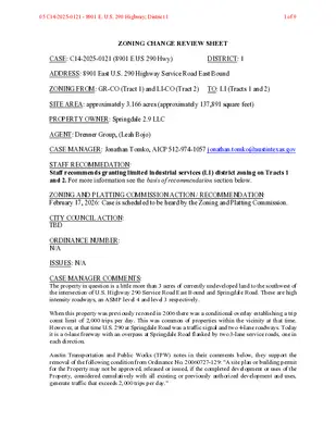
ZONING CHANGE REVIEW SHEET CASE: C14-2025-0121 (8901 E US 290 Hwy) DISTRICT: 1 ADDRESS: 8901 East U.S. 290 Highway Service Road East Bound ZONING FROM: GR-CO (Tract 1) and LI-CO (Tract 2) TO: LI (Tracts 1 and 2) SITE AREA: approximately 3.166 acres (approximately 137,891 square feet) PROPERTY OWNER: Springdale 2.9 LLC AGENT: Drenner Group, (Leah Bojo) CASE MANAGER: Jonathan Tomko, AICP 512-974-1057 jonathan.tomko@austintexas.gov STAFF RECOMMEDATION: Staff recommends granting limited industrial services (LI) district zoning on Tracts 1 and 2. For more information see the basis of recommendation section below. ZONING AND PLATTING COMMISSION ACTION / RECOMMENDATION: February 17, 2026: Case is scheduled to be heard by the Zoning and Platting Commission. CITY COUNCIL ACTION: TBD ORDINANCE NUMBER: N/A ISSUES: N/A CASE MANAGER COMMENTS: The property in question is a little more than 3 acres of currently undeveloped land to the southwest of the intersection of U.S. Highway 290 Service Road East Bound and Springdale Road. These are high intensity roadways, an ASMP level 4 and level 3 respectively. When this property was previously rezoned in 2006 there was a conditional overlay establishing a trip count limit of 2,000 trips per day. This was common of properties within the vicinity at that time. However, at that time U.S. 290 at Springdale Road was a traffic signal and two 4-lane roadways. Today it is a 6-lane freeway with an overpass at Springdale Road flanked by two 3-lane service roads, one in each direction. Austin Transportation and Public Works (TPW) notes in their comments below, they support the removal of the following condition from Ordinance No. 20060727-129: “A site plan or building permit for the Property may not be approved, released or issued, if the completed development or uses of the Property, considered cumulatively with all existing or previously authorized development and uses, generate traffic that exceeds 2,000 trips per day.” 05 C14-2025-0121 - 8901 E. U.S. 290 Highway; District 11 of 9 Limited industrial services (LI) zoning is appropriate at the site; it is the dominant zoning classification in the vicinity, particularly to the northwest. Almost all the property in the immediate area previously zoned community commercial (GR) was condemned with the right of way to the south of U.S. 290 when the highway was constructed. BASIS OF RECOMMENDATION: Zoning should promote the policy of locating retail and more intensive zoning near the intersections of arterial roadways or at the intersections of arterials and major collectors. Public facilities and services should be adequate to serve the set of uses allowed by a rezoning. Zoning should allow for reasonable use of the property. EXISTING ZONING AND LAND USES: ZONING LAND USES Site North South GR-CO and LI-CO Undeveloped Land GR-CO LI-CO East (across Springdale Road) LI-CO and I-RR West GR-CO U.S. 290 Highway and service roads An industrial warehouse of approximately 36,000 square feet with a commercial storefront of approximately 9,000 square feet. Three industrial warehouses of approximately 90,000; 69,000; and 15,000 square feet with commercial storefronts of approximately 12,000; 8,000; and 4,000 square feet respectively. Undeveloped Land NEIGHBORHOOD PLANNING AREA: Not in a Neighborhood Planning Area WATERSHED: Walnut Creek Watershed SCHOOLS: A.I.S.D. Jordan Elementary School Dobie Middle School LBJ Early College High School COMMUNITY REGISTRY LIST: Austin Neighborhoods Council, Colony Park/Lakeside Community Development Corp., Del Valle Community Coalition, Friends of Austin Neighborhoods, Friends of Northeast Austin, Homeless Neighborhood Association, Overton Family Committee AREA CASE HISTORIES: Number C14-2009-0015 (Reagan 290) Request To rezone from DR and I-RR to LI C14-03-0054 (Speedy Stop 216) To rezone from DR to GR Commission 04.21.2009 ZAP: To grant staff’s recommendation for LI-CO zoning on a 4-0 vote. 04.14.2003 ZAP: To grant staff’s City Council 05.14.2009: To grant LI-CO zoning on the consent agenda on a 7-0 vote. 05.22.2003: To grant GR-CO zoning on 05 C14-2025-0121 - 8901 E. U.S. 290 Highway; District 12 of 9 C14-96-0030 (8801 Hwy 290 East) C14-06-0108 (Milstead) To rezone from DR to GR-CO To rezone from I- RR to LI-CO the consent agenda on a 7-0 vote. 06.06.1996: To grant GR-CO zoning. 07.20.2006: To grant LI-CO zoning. recommendation for GR-CO zoning on a 9-0 vote. N/A 06.20.2006 ZAP: To grant staff’s recommendation for LI-CO zoning on the consent agenda by a 7-0 vote. RELATED CASES: C14-05-0164 – Previous rezoning of the site from I-RR and DR to GR-CO and LI-CO. ADDITIONAL STAFF COMMENTS: Comprehensive Planning Project Name and Proposed Use: 8901 E US 290 HWY SERVICE ROAD EB. C14-2025-0121. Project: 8901 E US 290 HWY SERVICE ROAD. 3.166 acres from GR-CO and LI-CO to LI. Existing: undeveloped. Proposed: gas station and store. Applicant is seeking to remove condition regarding the approval of a site plan or building permit. Yes Y Imagine Austin Decision Guidelines Complete Community Measures * Imagine Austin Growth Concept Map: Located within or adjacent to an Imagine Austin Activity Center, Imagine Austin Activity Corridor, or Imagine Austin Job Center as identified the Growth Concept Map. Names of Activity Centers/Activity Corridors/Job Centers *: • Adjacent to Manor/Springdale/Cameron Activity Corridor Y Mobility and Public Transit *: Located within 0.25 miles of public transit stop and/or light rail station. • 0.19 miles to bus stop along E US 290 HWY EB frontage road Y Mobility and Bike/Ped Access *: Adjoins a public sidewalk, shared path, and/or bike lane. • Bike lane present along Springdale Road Connectivity, Good and Services, Employment *: Provides or is located within 0.50 miles to goods and services, and/or employment center. Connectivity and Food Access *: Provides or is located within 0.50 miles of a grocery store/farmers market. Connectivity and Education *: Located within 0.50 miles from a public school or university. Connectivity and Healthy Living *: Provides or is located within 0.50 miles from a recreation area, park or walking trail. Connectivity and Health *: Provides or is located within 0.50 miles of health facility (ex: hospital, urgent care, doctor’s office, drugstore clinic, and/or specialized outpatient care.) Housing Choice *: Expands the number of units and housing choice that suits a variety of household sizes, incomes, and lifestyle needs of a diverse population (ex: apartments, triplex, granny flat, live/work units, cottage homes, and townhomes) in support of Imagine Austin and the Strategic Housing Blueprint. Housing Affordability *: Provides a minimum of 10% of units for workforce housing (80% MFI or less) and/or fee in lieu for affordable housing. Mixed use *: Provides a mix of residential and non-industrial uses. 05 C14-2025-0121 - 8901 E. U.S. 290 Highway; District 13 of 9 Culture and Creative Economy *: Provides or is located within 0.50 miles of a cultural resource (ex: library, theater, museum, cultural center). Culture and Historic Preservation: Preserves or enhances a historically and/or culturally significant site. Creative Economy: Expands Austin’s creative economy (ex: live music venue, art studio, film, digital, theater.) Workforce Development, the Economy and Education: Expands the economic base by creating permanent jobs, especially in industries that are currently not represented in a particular area or that promotes a new technology, and/or promotes educational opportunities and workforce development training. Industrial Land: Preserves or enhances industrial land. Not located over Edwards Aquifer Contributing Zone or Edwards Aquifer Recharge Zone Number of “Yes’s” Y 4 Environmental 1. The site is not located over the Edwards Aquifer Recharge Zone. The site is in the Walnut Creek Watershed of the Colorado River Basin, which is classified as a Suburban Watershed by Chapter 25-8 of the City's Land Development Code. The site is in the Desired Development Zone. 2. Under current watershed regulations, development or redevelopment on this site will be subject to the following impervious cover limits: Development Classification Single-Family Other Single-Family or Duplex Multifamily Commercial % of Gross Site Area % of Gross Site Area with Transfers 50% 55% 60% 80% 60% 60% 70% 90% 3. According to floodplain maps there is a floodplain within or adjacent to the project location. Based upon the location of the floodplain, offsite drainage should be calculated to determine whether a Critical Water Quality Zone exists within the project location. 4. Standard landscaping and tree protection will be required in accordance with LDC 25- 2 and 25-8 for all development and/or redevelopment. 5. At this time, site specific information is unavailable regarding vegetation, areas of steep slope, or other environmental features such as bluffs, springs, canyon rimrock, caves, sinkholes, and wetlands. 6. Under current watershed regulations, development or redevelopment requires water quality control with increased capture volume and control of the 2 year storm on site. 7. At this time, no information has been provided as to whether this property has any preexisting approvals that preempt current water quality or Code requirements. 05 C14-2025-0121 - 8901 E. U.S. 290 Highway; District 14 of 9 Fire No comments on rezoning PARD – Planning & Design Review PR1: Parkland dedication fees may apply to any future site or subdivision applications resulting from this rezoning. As of January 1, 2024, new commercial, non-residential uses are not subject to parkland dedication requirements at the time of site plan and subdivision. Site Plan 1. FYI: All comments regarding the effects of the proposed rezoning on subsequent Site Plan Review applications are intended to assist in identifying potential development regulations which may affect a specific constraints but do not include all proposal. Changes to property boundaries and requests for development cannot include all regulatory limitations which may apply to a specific subject to modification or reconsideration if affected by a change in property boundaries or if development is proposed on only a portion of the land proposed for rezoning. These comments are intended to assist in identifying potential development constraints, but do not address the actual restrictions which will apply to a specific development proposal. Austin Development Services offers a variety of pre-application review options to assist in evaluating specific development proposals prior to Site Plan Application. 2. Site plans will be required for any new development except for residential only project with up to 4 units. 3. Any new development is subject to Subchapter E. Design Standards and Mixed Use. Additional comments will be made when the site plan is submitted. Transportation and Public Works Department (TPW) – Engineering Review TPW 1. TPW-TDS supports the removal of the following condition from Ordinance No. 20060727-129: “A site plan or building permit for the Property may not be approved, released or issued, if the completed development or uses of the Property, considered cumulatively with all existing or previously authorized development and uses, generate traffic that exceeds 2,000 trips per day.” TPW 2. The Austin Strategic Mobility Plan (ASMP) calls for 116 feet of right-of-way for SPRINGDALE RD. It is recommended that 58’ feet of right-of-way from the existing centerline should be dedicated for SPRINGDALE RD according to the Transportation Plan with the first subdivision or site plan application. [LDC 25-6-51 and 25-6-55]. EXISTING STREET CHARACTERISTICS: Name ASMP Classification ASMP Required ROW Existing ROW Existing Pavement Sidewalks Bicycle Route Capital Metro (within ¼ mile) 05 C14-2025-0121 - 8901 E. U.S. 290 Highway; District 15 of 9 E US 290 HWY SVRD EB Level 4 (TXDOT) N/A Yes Yes Yes Varies: 42’ – 53’ (E US 290 HWY SVRD EB) 412’ (includes EB SVRD through WB SVRD) SPRINGDALE RD Level 3 116’ 90’ 65’ No yes Yes TIA: A Zoning transportation analysis shall be performed at time of zoning where anticipated trips are anticipated to exceed 2,000 unadjusted trips to satisfy the LDC requirement for a TIA but does not diminish the authority to require a traffic impact analysis at time of site plan. LDC 25-6, TCM 10.5.0. Austin Water Utility AW1. No comments on zoning change. FYI: The landowner intends to serve the site with existing City of Austin water utilities. Depending on the development plans submitted, water and or wastewater service extension requests may be required. All water and wastewater construction must be inspected by the City of Austin. For more information pertaining to the Service Extension Request process and submittal requirements contact the Austin Water SER team at ser@austintexas.gov. INDEX OF EXHIBITS AND ATTACHMENTS TO FOLLOW: A. Zoning Map B. Aerial Map C. Applicant’s Summary Letter 05 C14-2025-0121 - 8901 E. U.S. 290 Highway; District 16 of 9 05 C14-2025-0121 - 8901 E. U.S. 290 Highway; District 17 of 9 !!!!!!!!!!!!!!!!!!!!!!!!!!!!!!!!!!!!!!!!!!!!!!!!!!!!!!!!!!!!!!!!!!!!C14-2025-0121C14-00-2120C14-2011-0068C14-2013-0105C14-98-0189C14-97-0111C14-2013-0026C14-2011-0143C14-05-0164C14-06-0108C14-97-0071C14-98-0188C14-2023-0061C14-2009-0015C14-98-0188C14-03-0054C14-05-0216C14-96-0030C14-96-0027C14-2022-0043C14-2019-0076C14-05-0191C14-05-0214C14-2013-0149C14-96-0030C14-05-0173C14-05-0156C14-2008-0157C14-98-0142C14-2014-0022SPRINGDALE RDTUSCANY WAYE US 290 HWY EBE US 290 HWY WBE US 290 HWY SVRD EBE US 290 HWY SVRD WBFERGUSON CTOFSANSOM RDCOMMERCIAL PARK DRE US 290 EB RAMPE US 290 WB RAMPANDTREE BLVDVARA DRALTOGA DRCROSS PARK TO E US 290 WB RAMPOLD MANOR RDPLILI-COLI-COLILI-COI-RRLILOGR-COI-RRLI-CODRI-SF-2CS-COGR-COI-RRDRMF-4LI-COI-SF-2GRLI-COGRI-SF-2LI-COCS-1-COLI-COGR-CODRPP8901 E US 290 Highway±This product has been produced by Austin Planning for the sole purpose of geographic reference. No warranty is madeby the City of Austin regarding specific accuracy or completeness.ZONING CASE#:LOCATION:SUBJECT AREA:MANAGER:C14-2025-01218901 E US 290 Hwy Svrd EB3.166 AcresJonathan TomkoCreated: 1/21/2026SUBJECT TRACTZONING BOUNDARY!!!!!PENDING CASECREEK BUFFER1 inch equals 400 '05 C14-2025-0121 - 8901 E. U.S. 290 Highway; District 18 of 9 November 10, 2025 Ms. Lauren Middleton-Pratt, Planning Director City of Austin Planning Department Permitting and Development Center (PDC) 6310 Wilhelmina Delco Drive Austin, TX 78752 Via Electronic Delivery Re: 8901 E US 290 Highway – Zoning application for the combined 3.166-acre piece of property located at 8901 E US 290 Highway, comprised of TCAD IDs: 0229300406, 0229300405 and 0229280312 (the "Property"). Dear Ms. Middleton-Pratt: As representatives of the owners of the Property, we respectfully submit the enclosed rezoning application package. The project is titled 8901 E US 290 Highway and is 3.166-acres of land, located on the south side of E US 290 Highway, between Springdale Road and Tuscany Way. The Property is in the Full Purpose Jurisdiction of the City of Austin. The Property is currently zoned LI-CO (Limited Industrial Services – Conditional Overlay) and GR-CO (Community Commercial – Conditional Overlay). The requested zoning is LI (Limited Industrial Services). We are requesting to remove the following condition per Ordinance No. 20060727-129: A site plan or building permit for the Property may not be approved, released or issued, if the completed development or uses of the Property, considered cumulatively with all existing or previously authorized development and uses, generate traffic that exceeds 2,000 trips per day. The Property is not located in a Neighborhood Planning Area. A Traffic Impact Analysis (TIA) is pending at the Transportation Department Services. Please let me know if you or your team members require additional information or have any questions. Thank you for your time and attention to this project. Sincerely, Leah M. Bojo cc: Joi Harden, Planning Department (via electronic delivery) Jonathan Tomko (via electronic delivery) 2705 Bee Caves Road Suite 100 | Austin, Texas 78746 | 512-807-2900 | www.drennergroup.com 05 C14-2025-0121 - 8901 E. U.S. 290 Highway; District 19 of 9