03 SPC-2025-0156C - The Learning Center at Parmer; District 7 - Staff Report Part 2 — original pdf
Backup
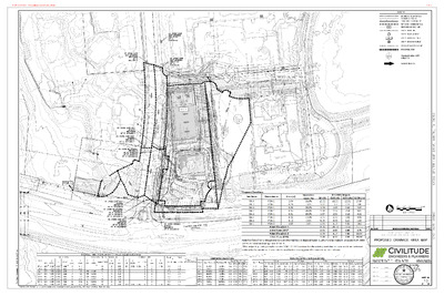
POA 2 REGIONAL WET POND E V I R D E K A L R E T N E C ) . . W O . R ' 0 9 ( POA 1 . . T T . . G G PARMER LANE (F.M. 734) (200' R.O.W.) 512 D LEGEND BOUNDARY / RIGHT OF WAY EASEMENT / SETBACK CURB / EDGE OF PAVEMENT RETAINING / SCREENING WALL PROPOSED CONTOUR LINE STORM DRAIN LINE STORM DRAIN MANHOLE STORM DRAIN CURB INLET STORM DRAIN GRATE INLET DRAINAGE SWALE FLOW LINE DRAINAGE AREA 00.0 % 0.00 Ac DRAINAGE AREA NAME AREA/IC % FLOW DIRECTION N 03 SPC-2025-0156C - The Learning Center at Parmer; District 78 of 12 MEDIUM & LARGE BUFFER SHRUBS CENTER LAKE DRIVE CENTER LAKE DRIVE (90' R.O.W.) (90' R.O.W.) SMALL TREE FOR STREET YARD, TYP. L.O.C L.O.C DY DY BM BM BM DY DY BM BM L . O . C L.O.C L.O.C L.O.C L . O . C S S S L.O.C L.O.C L.O.C L.O.C L.O.C L.O.C SD SD SD P S SD S SD SD SD S SD SHADE TREE FOR PARKING, TYP. L.O.C L.O.C L.O.C L.O.C L.O.C L.O.C SHADE TREE FOR STREET YARD, TYP. L.O.C L.O.C L.O.C L.O.C L.O.C L.O.C S S S L.O.C S L.O.C STREETYARD L.O.C L.O.C SHADE TREE FOR PARKING, TYP. L.O.C 10' ELEC. EASEMENT L.O.C L.O.C G A S LOT DELINEATION FOR STREET YARD SD SD G A S UE SD G A S U E U E U E S D S D S D S D S D S D S D S D L.O.C L.O.C SD L . O C . SD SD U E U E U E L . O C . STREETYARD W W G.T. L . O C . L . O C . L . O C . L . O C . L . O C . L . O C . L . O C . P L.O.C S L L.O.C . O C . L . O C . L . O C . L . O C . L . O C . L . O C . L . O C . L . O C . L . O C . L . O C . L . O C . L . O C . L . O C . L . O C . SD W W W SD LOT DELINEATION SD L.O.C W W SD L.O.C W SD L.O.C L.O.C W W W W SD W SD W W P SD SD SD SD SD SD R E T A W 5 1 T N E M W E S A E ' W L . O C . L . O C . L . O C . W W W W W W W W W L . O C . P . I N M ' 5 P W . L . O C L . O C . L.O.C L.O.C L.O.C L.O.C L.O.C L.O.C L.O.C L.O.C L.O.C L.O.C L.O.C L.O.C L.O.C L.O.C L.O.C L.O.C L.O.C W SHADE TREE FOR PARKING, TYP. SD SD SD SD SD SD SD SD SD SD SD SD W W L.O.C L.O.C L.O.C L.O.C L.O.C L.O.C L.O.C L.O.C L.O.C L.O.C W L.O.C W L.O.C L . O C . L . O C . L . O C . L . O C . L . O C . LANDSCAPE CALCULATIONS STREETYARD Total Site Area: Center Lake Drive Total Street Yard Area Street Yard / Landscape (20%) TREES (Street Yard) Existing Trees 6"+: (0) = 0 Trees Proposed Shade Trees = 9 Trees Proposed Small Trees = 2 Trees Required N/A N/A 1,582 sf (20%) 8 Provided 40,402 sf 7,910 sf 4,000 sf (50%) 11 REPLACEMENT TREES: PRIVATE Required Provided Total caliper inches to be replaced: Total Caliper Inches replaced: Canopy Trees: 0 x 3" = Split Credit Canopy Trees: 0 x 1.5" = Understory Trees: 0x 2" = 0" 0" 0" Total Inches Owed: 0" x $200 = $00 Proposed to Plant: Total Unmet Inches: Monetary value: HB7 Credit: 50% = 0" x $200 = $00 0" (0" - 0") 0" x $200 = $00 $00 ($100 x 0.5) New Unmet Inches: $00 ($0 - $0) TOTAL FEES OWED: $0 to UFRF ISLANDS MEDIANS, OR PENINSULAS Street Yard Area - 3 spots x 7.5 sf = 23 sf Non-Street Yard Area - 29 spots x 5 sf = 145 sf BUFFERING Medium preferred shub: 3 pts x 5 = 15 pts 12 pts Large preferred shrub: 3 pts x 4 = SURVEYED Total Appendix F Trees inches surveyed Heritage Tree inches surveyed Non-Appendix F Tree inches surveyed Invasive Tree inches surveyed REMOVED 0" N/A 0" 0" 0" 0" $0 $0 Required Provided 168 sf 200 sf Required Provided 27 pts 20 pts 0" 0" 0" 0" 0" Total Appendix F Trees inches REMOVED Heritage Tree inches REMOVED 0" Non-Appendix F Tree REMOVED 0" Invasive Tree inches REMOVED 0" Total Dead, Diseased, or Imminent Hazard (DDI) inches REMOVED 0" DDI Appendix F inches REMOVED 0" DDI Heritage tree inches REMOVED 0" DDI Non-Appendix F inches REMOVED 0" DDI Invasive inches REMOVED 0" MITIGATION Total mitigation replacement inches planted Total replacement inches planted on site (private trees) Total replacement ROW inches planted Private inches owed to Urban Forest Replenishment Fund (UFRF) Public inches owed to UFRF Total non-mitigation inches planted on site 0" 0" 0" 0" 0" 31" SHADE TREES LARGE SHRUBS SYMBOL QUANTITY COMMON NAME SCIENTIFIC NAME SIZE AND CONDITION SYMBOL QUANTITY COMMON NAME SCIENTIFIC NAME SIZE AND CONDITION 3 3 2 6 Cedar Elm Ulmus crassifolia 2" caliper / 8' height minimum BM 5 Big Muhly Muhlenbergia lindheirmeri 5 gal., 24" ht. Live Oak Quercus virginiana 2" caliper / 8' height minimum SYMBOL QUANTITY COMMON NAME SCIENTIFIC NAME SIZE AND CONDITION MEDIUM SHRUBS DY 4 Dwarf Yaupon Ilex vomitoria 'Nana' 5 gal., 24" ht. Monterrey Oak Quercus polymorpha 2" caliper / 8' height minimum Red Oak Quercus shumardii 2" caliper / 8' height minimum MISCELLANEOUS QUANTITY +/- 0 +/- 800 +/- 10,500 UTILITY COMPATIBLE SMALL TREES SYMBOL QUANTITY COMMON NAME SCIENTIFIC NAME SIZE AND CONDITION 2 Texas Redbud Cercis canadensis var. 'Texensis' 1.5" caliper / 6' height minimum CALLOUT DESCRIPTION 00 20' 40' 60' 80' SF 3" depth dark hardwood mulch. All planting areas, not called out as gravel S.F. Limestone Gravel, 1/2" DIA. applied a minimum of 3" depth S.F. Bermuda Tiff Sod / Hyrdo-Mulch NOTE: · No Trees shall be planted within the transmission easement · No Trees shall be planted within 25 feet of the base of the transmission structure. Vehicular access for Austin Energy trucks and equipment is always to be maintained within the easement. · Austin Energy will not be responsible for damage and/or removal of vegetation within the easement. NOTE: · If establishing vegetation during any stage of a drought, Section 6-4-30 may require a variance. Contact Austin Water Conservation staff at waterusecompvar@austintexas.gov or call (512) 974-2199. · The Owner will continuously maintain the required landscaping in accordance with LDC 25-2-984 · All landscaped areas are to be protected by 6 inch wheel curbs, wheelstops or other approved barriers as per ECM 2.4.7 · Finished elevation for parking-lot islands, medians, peninsulas, and similar landscape areas must be at least six (6) inches below the finished curb elevation to allow for placement of six (6) inches of topsoil [ECM 1.4.7] · All trees encroaching along the fire lane will be trimmed and maintained to provide a 14-foot vertical clearance above the fire lane at all times · Supplemental irrigation is required for newly planted, required landscape plants per LDC 25-8-1008, ECM 2.4.6, & ECM appendix O. NOTE: Vegetative screening, berms, fences, or yards shall be provided to screen adjacent SF-5 or more restrictive residential districts from views of off-street parking areas, mechanical equipment, storage areas, and for refuse collection [Section 25-2-1066]. I S N O S V E R I n o i t p i r c s e D e t a D CAANDS LD EP RE A R STE EY ADL T.JON C HI I T G E E C R T R B E S S TA ET 82 85 SA X ET OF 12/18/25 E R A C Y A D E G D R H C E T I 3 5 7 8 7 X T , I N T S U A , I E V R D E K A L R E T N E C I N A L P L A T T M B U S E P A C S D N A L DATE: 12-18-25 SCALE: 1" = 20' 6 3 7 8 7 S A X E T , N I T S U A , A E T I U S , R D E L C R C 3 8 1 1 1 I 4 0 2 9 - 4 4 3 - 2 1 5 I I M O C . P U O R G N G S E D D N A L O C E . W W W Sheet: L1 of L2 JOB#: E114-32 SP-2025-_____ 03 SPC-2025-0156C - The Learning Center at Parmer; District 79 of 12 03 SPC-2025-0156C - The Learning Center at Parmer; District 710 of 12 N 03 SPC-2025-0156C - The Learning Center at Parmer; District 711 of 12 Permitting and Development Center | 6310 Wilhelmina Delco Drive, Austin, TX 78752 | (512) 978-4000 Property Profile Report General Information Location: Parcel ID: Grid: 12705 CENTER LAKE DR 0258260404 M34 Planning & Zoning *Right click hyperlinks to open in a new window. Future Land Use (FLUM): No Future Land Use Map Regulating Plan: No Regulating Plan Zoning: Zoning Cases: Zoning Ordinances: LI-PDA C14-2008-0076 000518-75 19990225-070b 20081016-050 Zoning Overlays: Scenic Roadways Overlay: PARMER LANE ADU Approx Area Reduced Parking Infill Options: -- Neighborhood Restricted Parking Areas: -- Mobile Food Vendors: Historic Landmark: Urban Roadways: -- -- No Zoning Guide The Guide to Zoning provides a quick explanation of the above Zoning codes, however, the Land Use Assistance provides general zoning assistance and can advise you on the type of development allowed on a property. Visit Zoning for the description of each Base Zoning District. For official verification of the zoning of a property, please request a Zoning Verification Letter. General information on the Neighborhood Planning Areas is available from Neighborhood Planning. Environmental Fully Developed Floodplain: FEMA Floodplain: Austin Watershed Regulation Areas: Watershed Boundaries: Creek Buffers: Edwards Aquifer Recharge Zone: Edwards Aquifer Recharge Verification Zone: Erosion Hazard Zone Review Buffer: Political Boundaries No No SUBURBAN Walnut Creek No No No No Jurisdiction: AUSTIN FULL PURPOSE Council District: 7 County: TRAVIS School District: Pflugerville ISD Zoning Map Imagery Map Community Registry: Friends of Austin Neighborhoods, Homeless Neighborhood Association, Pflugerville Independent School District, Yager Community Vicinity Map The Information on this report has been produced by the City of Austin as a working document and is not warranted for any other use. No warranty is made by the City regarding its accuracy or completeness. Date created: 1/27/2026 03 SPC-2025-0156C - The Learning Center at Parmer; District 712 of 12